The Temperate Woodland Ecosystem
|
|
|
- Eustace Houston
- 5 years ago
- Views:
Transcription

1 The Temperate Woodland
2 Objectives To gain an appreciation of a real-world ecological system To create a new form of data presentation To be able to extrapolate data to suit new geographical scenarios
3 Where is Parkhurst Forest?

4 Where is Parkhurst Forest? 2017 Ordnance Survey


5 Where is Parkhurst Forest? 2017 Ordnance Survey
6 Describe the site and situation of Parkhurst Forest What key points could be included in location description?
7 2017 Ordnance Survey
8 1. Name the main road that runs along the southern most edge of Parkhurst Forest 2. Give the four-figure grid reference for the large clearing, found within Parkhurst Forest A
9 1. Name the main road that runs along the southern most edge of Parkhurst Forest 2. Give the four-figure grid reference for the large clearing, found within Parkhurst Forest A
10 1. Name the main road that runs along the southern most edge of Parkhurst Forest 2. Give the four-figure grid reference for the large clearing, found within Parkhurst Forest A
11 1. Name the main road that runs along the southern most edge of Parkhurst Forest 2. Give the four-figure grid reference for the large clearing, found within Parkhurst Forest A
12 3. Give the six-figure grid reference for Signal House, found within Parkhurst Forest 4. How many metres above sea level is Signal House? m
13 3. Give the six-figure grid reference for Signal House, found within Parkhurst Forest 4. How many metres above sea level is Signal House? m
14 3. Give the six-figure grid reference for Signal House, found within Parkhurst Forest 4. How many metres above sea level is Signal House? m
15 3. Give the six-figure grid reference for Signal House, found within Parkhurst Forest 4. How many metres above sea level is Signal House? m
16 3. Give the six-figure grid reference for Signal House, found within Parkhurst Forest 4. How many metres above sea level is Signal House? m
17 5. What is the straight-line distance from the most northerly point in Parkhurst Forest to its most southerly point? 6. What is the shortest distance possible between Parkhurst Forest and the River Medina? 3.1km 1.3km
18 5. What is the straight-line distance from the most northerly point in Parkhurst Forest to its most southerly point? 6. What is the shortest distance possible between Parkhurst Forest and the River Medina? 3.1km 1.3km
19 5. What is the straight-line distance from the most northerly point in Parkhurst Forest to its most southerly point? 6. What is the shortest distance possible between Parkhurst Forest and the River Medina? 3.1km 1.3km
20 5. What is the straight-line distance from the most northerly point in Parkhurst Forest to its most southerly point? 6. What is the shortest distance possible between Parkhurst Forest and the River Medina? 3.1km 1.3km
21 5. What is the straight-line distance from the most northerly point in Parkhurst Forest to its most southerly point? 6. What is the shortest distance possible between Parkhurst Forest and the River Medina? 3.1km 1.3km
22 7. What is found in grid square 4789 that may have an impact on the ecology in Parkhurst Forest? 8. If you were to walk from the top of Holme Hill to Camp Hill Prison, what bearing would you have taken? Works / Industrial Site 156
23 7. What is found in grid square 4789 that may have an impact on the ecology in Parkhurst Forest? 8. If you were to walk from the top of Holme Hill to Camp Hill Prison, what bearing would you have taken? Works / Industrial Site 156
24 7. What is found in grid square 4789 that may have an impact on the ecology in Parkhurst Forest? 8. If you were to walk from the top of Holme Hill to Camp Hill Prison, what bearing would you have taken? Works / Industrial Site 156
25 7. What is found in grid square 4789 that may have an impact on the ecology in Parkhurst Forest? 8. If you were to walk from the top of Holme Hill to Camp Hill Prison, what bearing would you have taken? Works / Industrial Site 156
26 7. What is found in grid square 4789 that may have an impact on the ecology in Parkhurst Forest? 8. If you were to walk from the top of Holme Hill to Camp Hill Prison, what bearing would you have taken? Works / Industrial Site 156
27 Source: Chloe Searl The Temperate Woodland An Introduction to Parkhurst Forest Parkhurst Forest is an area of mixed temperate woodland on the Isle of Wight. The forest is one of the oldest in the UK, with records showing its use as a royal hunting forest in medieval times. The forest is now managed by the Forestry Commission.
28 Source: Chloe Searl Source: Steve Childs (CC-BY-2.0) The Temperate Woodland The 395 hectare site, which includes 3 hectares of meadow in the centre of the forest, is unusually wild given its proximity to the centre of Newport, the county town of the Isle of Wight. Pearl bordered Fritillary The forest contains a large Napoleonic oak plantation and several significant areas of pine trees, home to a large proportion of the Island s 3,500 red squirrel population. Parkhurst Forest also provides a habitat for nationally rare species of butterfly and lichen.
29 Source: Chloe Searl The Temperate Woodland The forest is an important part of the tourism portfolio of the Island, and is well used by islanders and visitors. Vandalism, fires and fly-tipping do occur, but are relatively infrequent given the size and popularity of the forest.
30 What is discrete data? Discrete data is that which can only be measured using a specific numerical value. What is continuous data? Continuous data can (in theory) take any value and continue to an infinite number.
31 Discrete or Continuous? Age
32 Discrete or Continuous? Age Continuous
33 Discrete or Continuous? Number of something
34 Discrete or Continuous? Number of something Discrete
35 Discrete or Continuous? Temperature
36 Discrete or Continuous? Temperature Continuous
37 Discrete or Continuous? Velocity
38 Discrete or Continuous? Velocity Continuous
39 Discrete or Continuous? Percentage of something
40 Discrete or Continuous? Percentage of something Discrete
41 Discrete or Continuous? Distance
42 Discrete or Continuous? Distance Continuous

43 When using discrete data avoid: Line graphs Histograms Otherwise most other common forms of data presentation can be used.
44 Species found in a temperate woodland Species abundance Tree A Tree B Tree C Tree D Tree E Tree F 16 57
45 Species found in a temperate woodland What type of data is this? Species abundance Tree A Tree B Tree C Tree D Tree E Tree F 16 57
46 Species found in a temperate woodland What type of data is this? How might you present this data? Species abundance Tree A Tree B Tree C Tree D Tree E Tree F 16 57
47 You could present the data in bar charts: 3000 Species abundance A B C D E F
48 You could present the data in bar charts: 3000 Species abundance A B C D E F What problems can you see with this method?
49 You could present the data in pie charts: Species abundance in 1980 Species abundance in 2015 A B C D E F A B C D E F
50 You could present the data in pie charts: Species abundance in 1980 Species abundance in 2015 A B C D E F A B C D E F What problems can you see with this method?
51 You could present the data in a comparative bar chart: 3000 Species Abundance A B C D E F
52 You could present the data in a comparative bar chart: 3000 Species Abundance A B C D E F What problems can you see with this method?
53 100% 90% 80% % of species You could present the data in a composite bar chart: 70% 60% 50% 40% 30% 20% 10% 0% A B C D E F
54 100% 90% 80% % of species You could present the data in a composite bar chart: 70% 60% 50% 40% 30% 20% 10% 0% A B C D E F What problems can you see with this method?

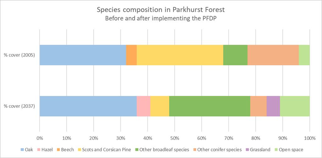
55 Parkhurst Forest is undergoing a conservation plan known as the Parkhurst Forest Design Plan (PFDP). It aims to bring more biodiversity into the woodland and retain its attraction for native red squirrels. As part of the PFDP, a species and ground cover survey was conducted in It is hoped that in 2037, when the PFDP concludes, the species and ground cover will be very different. Source: Hehaden (CC-BY-2.0)
56 Species % cover (2005) % cover (2037) Oak Hazel 0 5 Beech 4 0 Scots and Corsican Pine 32 7 Other broadleaf species 9 30 Other conifer species 19 6 Grassland 0 5 Open space 4 11
57
58 Acute Oak Decline Acute Oak Decline is the general term given to a bacterial infection that affects thousands of trees across Southern England. The bacteria infects the area directly under the bark of the tree, causing cracks to appear and stem fluid to ooze out. Oak weeping through bacterial infection Source: Ken-ichi Ueda CC BY-NC 2.0
59 A rise in the numbers of Oak Jewel Beetles, that lay their eggs under the bark of the trees is thought to have increased the number of affected trees, possibly due to the beetle becoming a means for the bacteria to spread between trees. Acute Oak Decline causes the tree to become starved of nutrients and once infected the tree sees a rapid decline, often resulting in death. Defra is currently undertaking a 1.1 million research project into Acute Oak Decline. Oak Jewel Beetle Source: Nigel Jones CC BY-NC-ND 2.0
60 What is extrapolation? To extrapolate is to estimate an extension of the existing data based on the pattern that data is currently displaying. This is often represented by a dotted line for something that will happen in the future.
61 How would you extrapolate this data?
62 How would you extrapolate this data? Trend line
63 If Acute Oak Decline was detected in this woodland what would happen to each species? Think about - Food webs and how species interact with each other - The shape of the line of you draw (does it have to be straight?)
64 Acute Oak Decline detected
65 Location of Parkhurst Forest
66 Where is Parkhurst Forest?
67 Where is Parkhurst Forest? 2017 Ordnance Survey
68 Where is Parkhurst Forest? 2017 Ordnance Survey
69 Describe the site and situation of Parkhurst Forest What key points could be included in location description?
70 Woodland Map Skills
71
72 1. Name the main road that runs along the southern most edge of Parkhurst Forest 2. Give the four-figure grid reference for the large clearing, found within Parkhurst Forest A
73 1. Name the main road that runs along the southern most edge of Parkhurst Forest 2. Give the four-figure grid reference for the large clearing, found within Parkhurst Forest A
74 1. Name the main road that runs along the southern most edge of Parkhurst Forest 2. Give the four-figure grid reference for the large clearing, found within Parkhurst Forest A
75 1. Name the main road that runs along the southern most edge of Parkhurst Forest 2. Give the four-figure grid reference for the large clearing, found within Parkhurst Forest A
76 3. Give the six-figure grid reference for Signal House, found within Parkhurst Forest 4. How many metres above sea level is Signal House? m
77 3. Give the six-figure grid reference for Signal House, found within Parkhurst Forest 4. How many metres above sea level is Signal House? m
78 3. Give the six-figure grid reference for Signal House, found within Parkhurst Forest 4. How many metres above sea level is Signal House? m
79 3. Give the six-figure grid reference for Signal House, found within Parkhurst Forest 4. How many metres above sea level is Signal House? m
80 3. Give the six-figure grid reference for Signal House, found within Parkhurst Forest 4. How many metres above sea level is Signal House? m
81 5. What is the straight-line distance from the most northerly point in Parkhurst Forest to its most southerly point? 6. What is the shortest distance possible between Parkhurst Forest and the River Medina? 3.1km 1.3km
82 5. What is the straight-line distance from the most northerly point in Parkhurst Forest to its most southerly point? 6. What is the shortest distance possible between Parkhurst Forest and the River Medina? 3.1km 1.3km
83 5. What is the straight-line distance from the most northerly point in Parkhurst Forest to its most southerly point? 6. What is the shortest distance possible between Parkhurst Forest and the River Medina? 3.1km 1.3km
84 5. What is the straight-line distance from the most northerly point in Parkhurst Forest to its most southerly point? 6. What is the shortest distance possible between Parkhurst Forest and the River Medina? 3.1km 1.3km
85 5. What is the straight-line distance from the most northerly point in Parkhurst Forest to its most southerly point? 6. What is the shortest distance possible between Parkhurst Forest and the River Medina? 3.1km 1.3km
86 7. What is found in grid square 4789 that may have an impact on the ecology in Parkhurst Forest? 8. If you were to walk from the top of Holme Hill to Camp Hill Prison, what bearing would you have taken? Works / Industrial Site 156
87 7. What is found in grid square 4789 that may have an impact on the ecology in Parkhurst Forest? 8. If you were to walk from the top of Holme Hill to Camp Hill Prison, what bearing would you have taken? Works / Industrial Site 156
88 7. What is found in grid square 4789 that may have an impact on the ecology in Parkhurst Forest? 8. If you were to walk from the top of Holme Hill to Camp Hill Prison, what bearing would you have taken? Works / Industrial Site 156
89 7. What is found in grid square 4789 that may have an impact on the ecology in Parkhurst Forest? 8. If you were to walk from the top of Holme Hill to Camp Hill Prison, what bearing would you have taken? Works / Industrial Site 156
90 7. What is found in grid square 4789 that may have an impact on the ecology in Parkhurst Forest? 8. If you were to walk from the top of Holme Hill to Camp Hill Prison, what bearing would you have taken? Works / Industrial Site 156
91 Introduction to Parkhurst Forest

92 Source: Chloe Searl The Temperate Woodland An Introduction to Parkhurst Forest Parkhurst Forest is an area of mixed temperate woodland on the Isle of Wight. The forest is one of the oldest in the UK, with records showing its use as a royal hunting forest in medieval times. The forest is now managed by the Forestry Commission.
 The Temperate Woodland The 395 hectare site, which includes 3 hectares of meadow in the centre of the forest, is unusually wild given")

93 Source: Chloe Searl Source: Steve Childs (CC-BY-2.0) The Temperate Woodland The 395 hectare site, which includes 3 hectares of meadow in the centre of the forest, is unusually wild given its proximity to the centre of Newport, the county town of the Isle of Wight. Pearl bordered Fritillary The forest contains a large Napoleonic oak plantation and several significant areas of pine trees, home to a large proportion of the Island s 3,500 red squirrel population. Parkhurst Forest also provides a habitat for nationally rare species of butterfly and lichen.

94 Source: Chloe Searl The Temperate Woodland The forest is an important part of the tourism portfolio of the Island, and is well used by islanders and visitors. Vandalism, fires and fly-tipping do occur, but are relatively infrequent given the size and popularity of the forest.
95 Woodland Species Data
96 Species found in a temperate woodland Species abundance Tree A Tree B Tree C Tree D Tree E Tree F 16 57
97 Species found in a temperate woodland What type of data is this? Species abundance Tree A Tree B Tree C Tree D Tree E Tree F 16 57
98 Species found in a temperate woodland What type of data is this? How might you present this data? Species abundance Tree A Tree B Tree C Tree D Tree E Tree F 16 57
99 You could present the data in bar charts: 3000 Species abundance A B C D E F
100 You could present the data in bar charts: 3000 Species abundance A B C D E F What problems can you see with this method?
101 You could present the data in pie charts: Species abundance in 1980 Species abundance in 2015 A B C D E F A B C D E F
102 You could present the data in pie charts: Species abundance in 1980 Species abundance in 2015 A B C D E F A B C D E F What problems can you see with this method?
103 You could present the data in a comparative bar chart: 3000 Species Abundance A B C D E F
104 You could present the data in a comparative bar chart: 3000 Species Abundance A B C D E F What problems can you see with this method?
105 100% 90% 80% % of species You could present the data in a composite bar chart: 70% 60% 50% 40% 30% 20% 10% 0% A B C D E F
106 100% 90% 80% % of species You could present the data in a composite bar chart: 70% 60% 50% 40% 30% 20% 10% 0% A B C D E F What problems can you see with this method?
107 Acute Oak Decline

108 Acute Oak Decline is the general term given to a bacterial infection that affects thousands of trees across Southern England. The bacteria infects the area directly under the bark of the tree, causing cracks to appear and stem fluid to ooze out. Oak weeping through bacterial infection Source: Ken-ichi Ueda CC BY-NC 2.0

109 A rise in the numbers of Oak Jewel Beetles, that lay their eggs under the bark of the trees is thought to have increased the number of affected trees, possibly due to the beetle becoming a means for the bacteria to spread between trees. Acute Oak Decline causes the tree to become starved of nutrients and once infected the tree sees a rapid decline, often resulting in death. Defra is currently undertaking a 1.1 million research project into Acute Oak Decline. Oak Jewel Beetle Source: Nigel Jones CC BY-NC-ND 2.0