Wildfire Recovery PROTECTING YOUR PROPERTY FROM SOIL EROSION
|
|
|
- Hope Terry
- 5 years ago
- Views:
Transcription


1 Wildfire Recovery PROTECTING YOUR PROPERTY FROM SOIL EROSION


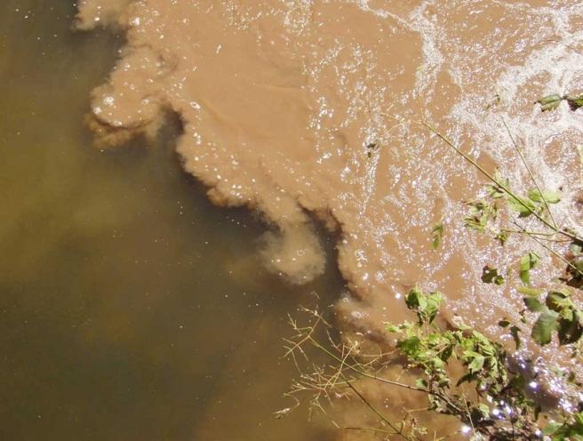
2 WILDFIRE RECOVERY: PROTECTING YOUR PROPERTY FROM SOIL EROSION The environmental impacts of a wildfire go far beyond burnt trees. The potential for severe soil erosion and accelerated water runoff also exists after a wildfire due to the lack of vegetation and ground cover to stabilize the soil. The trees, shrubs, grasses, and ground cover that comprise a healthy forest function to keep soil in place on the land. The forest canopy intercepts raindrops and reduces their impact on the soil. Rain that makes it through the canopy is intercepted by the litter layer which covers the forest floor. Together, the canopy and litter layer protect the soil by preventing raindrops from detaching soil particles. Without this protection, detached soil particles can wash down denuded slopes, enter stream channels, reduce water quality, and alter or degrade aquatic habitat. In addition to protecting soil from the impact force of raindrops, a litter layer functions to help the soil absorb rainwater. In the absence of litter, rain is more likely to hit the soil surface and run off than infiltrate into the soil, reducing aquifer recharge and increasing sediment loads delivered to nearby surface water bodies. Erosion robs land of its soil and its ability to grow trees. Losing nutrient-rich topsoil diminishes productivity and hinders the re-establishment of natural vegetation in burnedover areas following a fire. Soil and ash eroding off the land can wash into surface water bodies like ponds, wetlands, creeks and rivers (a process called sedimentation) causing negative impacts on water quality and aquatic habitat that can span from hours to years. Severe erosion can result in tremendous environmental and economic consequences by filling reservoirs and reducing their water storage capacity, deteriorating water quality, increasing treatment costs for drinking water, destroying aquatic ecosystems, and reducing biodiversity. Fortunately, there are a number of practical measures landowners can take to mitigate soil erosion caused by wildfire and to prevent sedimentation of ponds, creeks, streams, wetlands, and other surface water bodies. Most erosion control practices are designed to hold soil in place and protect it from washing away until permanent vegetation is re-established. There are a vast number of practices that can be applied across the landscape, when necessary. Selecting the right one will depend on the erosion risk, objectives of the treatment, economics, and the specific site conditions. Technical specifications for proper implementation are available for each practice. 1 Your property is at increased risk for soil erosion if: The forest litter layer has burned off, exposing bare soil The forest canopy has burned away, reducing rainfall interception The fire was of high intensity causing soil to repel water Slopes are steep Rain falls in large amounts over a short period of time


3 AFTER THE FIRE: PREVENTING SOIL EROSION WHAT SHOULD YOU DO FIRST? The following are some simple precautions you should take immediately following a wildfire to prevent from provoking soil erosion and sedimentation on your property: Plan for erosion control Recovery efforts such as land clearing, debris removal, and salvage logging should include plans for controlling erosion and sedimentation. Seek technical assistance from qualified professionals when necessary. Preserve existing vegetation Whether burned or unburned, the roots of vegetation hold the soil together and promote water infiltration. It is especially important to protect green trees and other vegetation adjacent to stream channels and surface waters. However, trees or shrubs that pose an imminent hazard to health and safety should be removed. Minimize soil disturbance When conducting any recovery efforts that involve soil disturbance, such as land clearing or road construction, attempt to minimize the footprint of the disturbance as much as possible. Be especially careful to minimize any disturbances in sensitive areas such as steep slopes, severely burned areas, erodible soils, and areas directly adjacent to wetlands, streams or other water bodies. Texas Forest Service Water Resources Program P.O. Box 310 Lufkin, TX or 2127 S. First St. Lufkin, TX (936) (voice) (936) (fax) Reduce the impact of livestock After a wildfire, some areas may need to be deferred until plant growth has re-established and is adequate to support grazing. Utilize forestry best management practices when salvaging trees Forestry Best Management Practices (BMPs) are conservation practices that help protect your soil and water resources during forestry operations. BMPs include practices like leaving a buffer of trees next to a stream, keeping slash and other debris out of stream channels, minimizing the number of vehicular stream crossings used to access a property, or re-establishing vegetation on temporary roads to prevent erosion. 2
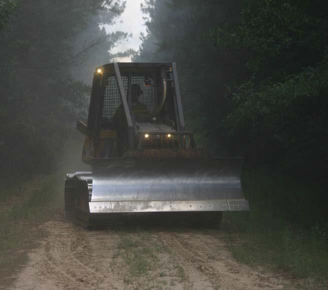
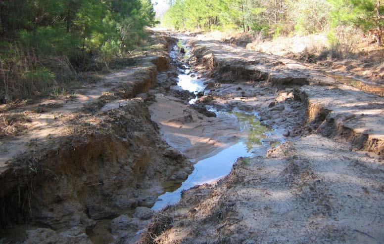
4 REHABILITAING FIREBREAKS AND TEMPORARY ROADS FOR WATER RESOURCE PROTECTION During wildfire suppression, it is often necessary to mechanically create breaks within the vegetation or other combustible materials to stop or slow the progress of a fire, and to push new temporary roads to facilitate the movement of firefighting equipment. These activities expose soils to erosion and increase the risk of sediment delivery to adjacent surface waters, especially on steep slopes, erodible soils, and in close proximity to water bodies. However, practices that prevent soil erosion can slow containment efforts and must take a lower priority than fire suppression as the first and foremost concern in wildfire control is to prevent damage to people and property. Best Management Practices (BMPs) for firelines should be used to address potential problems as soon as possible and whenever practical. The following BMPs can be used to rehabilitate firebreaks and temporary roads created during fire suppression activities: Firebreaks and temporary roads should have water control structures, such as waterbars and wing ditches (see Soil Erosion Appendix), installed to minimize soil erosion. These structures should not discharge within 50 feet of a stream bed or channel. Without providing drainage, roads and firebreaks can collect runoff water from the surrounding landscape and create a gully that funnels sediment long distances, potentially discharging them into streams or other water bodies. Stabilize and re-vegetate temporary roads and firebreaks, if needed, on grades in excess of 5% or areas subject to accelerated erosion or within known sensitive areas. Exposed soil subject to excessive erosion, especially erodible soils on steep slopes, should be re-vegetated or otherwise stabilized if natural re-vegetation will not suffice (see Soil Erosion Appendix). Roads that are no longer needed should be closed. Stream crossings and tie-ins should be rehabilitated whenever practical. Firebreaks and roads must sometimes cross through or connect to a stream or other water body. It is important to remove any dirt that is pushed into the stream that will obstruct the natural flow of the channel, and to reshape and stabilize the banks to ensure that no sediment can wash off the road or firebreak into the stream. Firebreaks and roads on highly erodible sites or other problem areas should be inspected periodically to correct erosion problems. Periodic inspections can help ensure that protective measures that have been taken are still functioning correctly, and that new problems have not arisen. Detecting problems while they are still small can save a lot of time, effort, and cost. 3
5 WILDFIRE SALVAGE BEST MANAGEMENT PRACTICES FOR WATER RESOURCE PROTECTION The destruction caused by wildfire leaves many forest landowners searching for answers about what to do with all the burned timber. Salvaging this timber quickly and starting over may be the only option for many. Generally, burned timber must be salvaged within approximately 2 months in order to utilize it for most wood products (biomass being one exception). While there is a sense of urgency to harvest the damaged timber, it is important to remember the long term benefits of using Best Management Practices (BMPs). Here are some things to keep in mind during these operations: Seek assistance from professional foresters and loggers. Trained professionals are familiar with BMPs necessary for protecting water quality, and data collected by Texas Forest Service shows that these individuals are more likely to implement BMPs during forestry operations. Special care should be taken when operating in the Streamside Management Zone (SMZ) to minimize ground disturbance. SMZs extend a minimum 50 feet from perennial and intermittent streams. They act as the final filter before any sediment or debris reaches the water body. Haul roads, skid trails, and landings should be located outside of these areas and kept to the minimum size and number necessary. Stream crossings should be avoided or minimized. Trees and tops should not be felled across or pushed into streams. Every effort should be made to protect and leave trees not severely damaged in the SMZ. This is critical to prevent destroying the filtering and stream shading effects of SMZs. A residual density of 50 square feet of basal area per acre should be left wherever possible (for basal area calculation refer to the Texas Forestry Best Management practices handbook). Tree survival can be determined using the Texas Forest Service debris assessment guidelines *. A professional arborist can be consulted if it is unclear if particular trees may or may not survive and should be removed. Evaluate the regeneration potential of the SMZ. If artificial regeneration is necessary, site preparation and machine planting should be avoided within the SMZ. Follow BMP protocols for the rest of the tract and use common sense. Despite the necessity to facilitate a quick harvest, BMPs should still be followed. Refer to the Texas Forestry Best Management Practices handbook for a complete list of BMPs applicable to forestry operations. Common sense will go a long way in keeping operators safe and preventing excessive damage to the site. * Information available from Document available from the Texas Forest Service website: 4
6 SOIL EROSION APPENDIX TECHNICAL GUIDENCE WATER CONTROL STRUCTURES o Waterbar Specification o Wing ditch Specifications SILT FENCE SPECIFICATIONS i.
 1-2 feet in height (pull dirt pushed out of firebreak back in to build the waterbar) Uphill end tied into bank to capture water across")

7 WATER CONTROL STRUCTURES WATERBAR a constructed berm of dirt used to collect and divert runoff water from a firebreak, dirt road, or other disturbed area to facilitate drainage and minimize erosion. Construct at a degree angle (should not function as a dam) 1-2 feet in height (pull dirt pushed out of firebreak back in to build the waterbar) Uphill end tied into bank to capture water across full length of surface Outflow end must be open Outflow should discharge into stable vegetation when possible. In heavily burned areas the outflow may need to be controlled using slash, weed-free straw bales, silt fence, or other erosion control measures to prevent further erosion Avoid constructing in WMZs A Bank tie-in point, cut 1 2 feet into the surface B Cross drain berm height is 1 2 feet above surface C Drain outlet cut 1 3 feet into surface D Angle drain degrees downgrade with surface centerline E Approximately 2 feet in height F Depth 1 2 feet G 3-4 feet Figure reprinted from the Texas Forestry Best Management Practices Handbook, Pg 36. Properly constructed waterbar and outlet for dispersing water. ii.
 o Even relatively flat slopes will")
8 WATERBAR SPACING FACTORS Slope o The steeper the slope, the more waterbars will be needed o Percent Slope = (Rise/Run) * 100% Soil Texture o 3 major soil textures Sand Coarse particles, best drainage, high erodibility more WB Silt Medium sized particles, drainage, erodibility Clay Fine particles, poor drainage, low erodibility less WB Distance (Run) o Even relatively flat slopes will need water control structures if they cover long distances. WATERBAR SPACING Spacing based on a known grade: Table reprinted from the Texas Forestry Best Management Practices Handbook, Pg 35. Grade (Percent) Distance between Waterbars (Feet) Spacing based on Eye Level approximation: Stand at the bottom of the slope, look straight ahead and locate a waterbar where your sight line meets the slope. Move to that location and repeat the process. Waterbar #3 Waterbar #2 Waterbar #1 iii.


9 WING DITCH / TURNOUT a diversion ditch constructed to collect and disperse runoff water away from the firebreak or road into stabilized areas. Usually connected to the outlet of a waterbar Construct at a degree angle, then follow the natural contour Has a slight uphill hook to slow water velocity Flattens at opening to spread water out and slow velocity Outflow should discharge into stable vegetation when possible. In heavily burned areas the outflow may need to be controlled using slash, weed-free straw bales, silt fence, or other erosion control measures to prevent further erosion Should not discharge into streams, wetlands or other waterbodies Example of a water turnout. A flat spreader spreads runoff water out, reducing its velocity so that sediment falls out prior to discharging into a stable vegetated area. Figure reprinted from Texas Forestry Best Management Practices Handbook, Pg. 39. Turnout used in conjunction with a waterbar to disperse runoff water WING DITCH / TURNOUT SPACING Table reprinted from the Texas Forestry Best Management Practices Handbook, Pg 38 Grade (Percent) Distance between Wing Ditches (Feet) iv.
10 EPA RECCOMENDATIONS FOR SILT FENCE INSTALLATION If a standard-strength fabric is used, it can be reinforced with wire mesh behind the filter fabric. This increases the effective life of the fence. The maximum life expectancy for synthetic fabric silt fences is about 6 months, depending on the amount of rainfall and runoff. The stakes used to anchor the filter fabric should be wood or metal. Wooden stakes should be at least 5 feet long and have a minimum diameter of 2 inches if a hardwood like oak is used. Stakes from soft woods like pine should be at least 4 inches in diameter. When using metal posts in place of wooden stakes, they should weigh at least 1.00 to 1.33 lb/linear foot. If metal posts are used, attachment points are needed for fastening the filter fabric with wire ties. Filter fence can be attached to wooden posts using heavy duty staples or hog rings. Erect silt fence in a continuous fashion from a single roll of fabric to eliminate gaps in the fence. If a continuous roll of fabric is not available, overlap the fabric from both directions only at stakes or posts. Overlap at least 6 inches. Excavate a trench to bury the bottom of the fabric fence at least 6 inches below the ground surface. This helps to prevent gaps from forming near the ground surface. Key Points The height of a silt fence should be a minimum of 16 inches above the original ground surface and should not exceed 34 inches above ground elevation. If standard-strength fabric is used with wire mesh, space the posts no more than 10 feet apart. If extra-strength fabric is used without wire mesh reinforcement, space the posts no more than 6 feet apart. If a silt fence is to be constructed across a ditch line or swale, the measure should be of sufficient length to eliminate endflow, and the plan configuration should resemble an arc or horseshoe with the ends oriented upslope. Extra-strength filter fabric with a maximum 3-foot spacing of posts should be used for this application. Silt fences should be removed when they have served their useful purpose, but not before the upslope area has been permanently stabilized. Position the silt fence at a right-angle (perpendicular) to the direction of surface runoff flow. Make sure the stakes supporting the silt fence are on the down-slope (back) side of the fence. Dig a trench at least 4 to 6 inches deep on the upslope side to bury the bottom portion of the silt fence. Bury the bottom portion of the silt fence with soil to make sure no runoff can seep underneath. Keep the silt fence upright and tightlystretched while installing. Install additional staking or straw bales behind the silt fence as necessary to prevent the silt fence from blowing-out. Silt fences should be removed when they have served their useful purpose, but not before the upslope area has been permanently stabilized. v.