Creating a Value-Added Wetlands Layer: Enhancing the Utility of Wetland Mapping in Montana Karen Newlon Montana Natural Heritage Program Helena, MT
|
|
|
- Loren Small
- 5 years ago
- Views:
Transcription


1 Creating a Value-Added Wetlands Layer: Enhancing the Utility of Wetland Mapping in Montana Karen Newlon Montana Natural Heritage Program Helena, MT


2 Wetlands & Riparian Mapping Wetland and riparian digital mapping are a data layer in the Montana Spatial Data Infrastructure. Goal: create statewide digital wetland and riparian mapping.

3 Wetland and Riparian Classification Standards

4 Riparian definition: Plant communities contiguous to and affected by surface and subsurface hydrologic features of rivers, streams, lakes, or drainage ways. Riparian areas are usually transitional between wetland and upland. Different vegetative species than adjacent areas The same species but exhibiting more vigorous or robust growth forms.

5 Riparian Mapping Woody riparian areas associated with lotic systems are the predominant features Emergent cover is also mapped if imagery allows for identification of these features

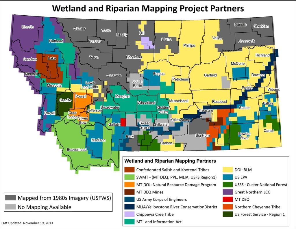
6 Wetland and Riparian Mapping Center Started in 2006 with funding from an EPA Wetland Program Development Grant Seven full-time photo interpreters Have access to necessary infrastructure and software Funding comes from many partners
7

8

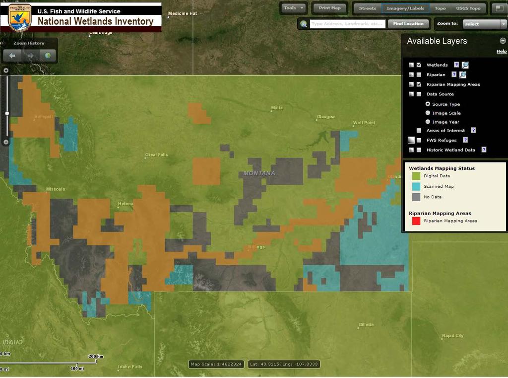
9 Accessing Wetland and Riparian Mapping Download Geodatabase from Montana Geographic Information ftp://ftp.gis.mt.gov/wetlandsframework/

10 Accessing Wetland and Riparian Mapping landsriparian/mapserver
11
12 Uses of Wetland and Riparian Mapping in Montana Complete picture of wetland and riparian resources in Montana Evaluate wetland losses/gains Preliminary site assessment for the presence of wetlands Facility and transportation/corridor siting Conservation incentive programs Conservation area planning NAWCA grants Tribal wetland protection ordinances Restoration planning Fisheries protection Floodplain management Water quality protection Watershed restoration Plant and wildlife survey stratification
13 Enhancing Wetlands Data Cowardin classification identifies wetland type based largely on vegetation (biotic) Useful to have information on abiotic properties of wetlands Enhance the utility of wetlands data by adding HGM descriptors
14 LLWW: Landscape Position, Landform, Water Flow Path, Waterbody type Set of descriptors developed by Ralph Tiner with USFWS for the eastern U.S. Based on geomorphic setting, water source, and hydrodynamics Links wetland type with wetland function (biotic/abiotic) Predict potential wetland function
15 Landscape Position (L): Lentic (LE) lake shores Lotic (LO) river/stream shores and floodplains Terrene (TE) surrounded by upland Landform (L): Basin (BA) depression Floodplain (FP) subject to river/stream overflow Slope (SL) occurs on a slope or has groundwater inputs Flat (FL) occurs on relatively flat landform and has precipitation as primary input LLWW Descriptors Image from:
: Lake (LK) Pond (PD) River (RV) Stream (ST) Image from: http://www.aswm.")
16 LLWW Descriptors Water Flow Path (W): Inflow (IN) Outflow (OU) Throughflow (TH) Bidirectional (BI) Isolated (IS) Waterbody Type (W): Lake (LK) Pond (PD) River (RV) Stream (ST) Image from:


17 Cowardin Class Water Flow Path


18 Locate Wetlands with Significance for Particular Functions
19 120,000 Number of Wetland LLWW Acres Descriptors with Potential for High Functional Performance 100,000 80,000 Acres 60,000 40,000 20,000 0 Water Storage Streamflow Groundwater Maintenance Recharge Nutrient Cycling Sediment Retention Shoreline Stabilization Native Plant Community Maintenance Terrestrial Habitat Aquatic Habitat Conservation of Wetland Biodiversity Potential Wetland Functions

20 LLWW in Montana predict changes in wetland function in rapidly developing watersheds required manual photointerpretation not feasible over large areas needed to adapt original classification to Montana needed to automate the process

21 LLWW in Montana received 2012 NSDI-CAP grant from the FGDC develop geoprocessing procedures develop training materials reviewed by project partners and technical advisors
22 LLWW in Montana ideally fully automate assignment of descriptors tradeoff between accuracy and efficiency fully automated approach: overall accuracy ranged from 60% in Oklahoma to 81% in Oregon certain wetland types can be assigned more accurately than others MTNHP developed semi-automated procedures
23 Limitations accuracy of source data (i.e., wetland mapping) accuracy of ancillary data layers used to assign LLWW descriptors individual wetland polygon may encompass more than one LLWW type level of subjectivity
24 LLWW Descriptors: Challenges Combines: wetland ecology wetland hydrology GIS

25 LLWW Descriptors: Ancillary Data Layers Aerial Orthoimagery Digital Raster Graphic Highresolution NHD 10m Digital Elevation Model Soil Survey Geographic Database

26 LLWW Descriptors: Challenges does the order in which descriptors are assigned matter? which polygons can be assigned in a fully automated way?
27 LLWW Descriptors: Example Select Queries River (RV): Select by Attributes: Create a new selection: "ATTRIBUTE" LIKE 'R2UB%' OR "ATTRIBUTE" LIKE 'R2AB%'. Populate Waterbody field with RV. Select by Attributes: Create a new selection: ATTRIBUTE LIKE R%UB% OR ATTRIBUTE LIKE R%AB% AND ATTRIBUTE NOT LIKE R%x. Select by Location: select from the currently selected features from Target layer: check wetland layer. Source layer: NHDArea attribute = StreamRiver. Spatial selection method: Target layer(s) features intersect the Source layer feature (NHDArea). Populate Waterbody field with RV.
28 LLWW Training Materials fact sheet
29 LLWW Training Materials fact sheet dichotomous key to LLWW descriptors
30 LLWW Training Materials fact sheet dichotomous key to LLWW descriptors list of LLWW codes


31 LLWW Training Materials fact sheet dichotomous key to LLWW descriptors list of LLWW codes glossary of terms
32 LLWW Descriptors: Next Steps Accuracy assessment Develop a tool Refine ancillary data layers

33 LLWW Descriptors: Challenges - Accuracy

34 LLWW Descriptors: Challenges
35 LLWW Descriptors: Next Steps Accuracy assessment Develop a tool Refine ancillary data layers

36 Develop Toolbox
37 LLWW Descriptors: Next Steps Accuracy assessment Develop a tool Refine ancillary data layers

38 Potentially Wet Soils
39 LLWW Descriptors: Next Steps Develop work plan for incorporating LLWW descriptors into existing wetland mapping Develop a functional correlation matrix for Rocky Mountain wetlands

40 8-Digit HUCs
41 LLWW Descriptors: Next Steps Develop work plan for incorporating LLWW descriptors into existing wetland mapping Develop a functional correlation matrix for Rocky Mountain wetlands

42 Develop Correlation Matrix for Montana
43 Useful Links ftp://ftp.gis.mt.gov/wetlandsframework/ SDI_Framework/WetlandsRiparian/MapServer

44 Acknowledgments NSDI-CAP grant Ralph Tiner U.S. Fish and Wildlife Service Colorado Natural Heritage Program: Joanna Lemly, Gabrielle Smith, Jeremy Sueltenfuss Dennis Lichtenberg CNL World Steve Carpenedo - Montana DEQ
45 Questions? Karen Newlon Montana Natural Heritage Program