Tracking Restoration Success
|
|
|
- Brian Wilkerson
- 5 years ago
- Views:
Transcription
1 Tracking Restoration Success A Presentation on Duette Preserve Environmental Monitoring Program Parks & Natural Resources Department Environmental Protection Division 1112 Manatee Avenue West, Suite 203 Bradenton, FL Phone: (941)
2 Problem Statement Manatee County Parks and Natural Resources Department is tasked with active management of Duette Preserve, a 21,000-acre park. Staff was looking for a way to better understand, quantify, and document the tangible benefits of hydrologic restoration activities on a large scale.
3 Brief History Lake Manatee Reservoir is the principal drinking water supply for Manatee County. Duette Preserve is 21,000 acres, contains North Fork and East Fork of the Manatee River. The Board of County Commissioners approved the Land Management Plan on January 9, 1996.

4
5 Management Plan prescribed fire program wildlife population surveys controlled hunt program pine flatwoods restoration scrub management hydrologic restoration of wetlands and unnamed tributaries of the North Fork and East Fork of the Manatee River.

6 Hydrologic Restoration restore historical water retention capacity enhance onsite wetlands

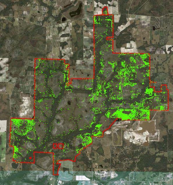
7 Locations of Ditch Blocks and WAP Sites

8 Example Ditch Block (source: Manatee County)

9 Example Backfill of Ditch Backfill (source: Manatee County)

10 Area 2 Stream Rehydration (source: Manatee County)
11 Monitoring Program 3 year data intensive monitoring program efficiently document changes over a large area water storage wetland acreage vegetative composition
12 Monitoring Protocol Hyperspectral Imaging utilizes specialized spectral aerial imaging and mapping techniques supported by on-the-ground field studies: soil moisture wetland hydration functional vegetative condition (WAP method)

13 ADS40: broad-band multispectral mapping camera system Hyperspectral Imaging (source: Leica Geosystems)


14 Hyperspectral Imaging (source: Leica Geosystems)
 Water Band Index (WBI) % Soil Moisture (source: Manatee")
15 Hyperspectral Imagery Analysis Normalized Difference Vegetation Index (NDVI) Water Band Index (WBI) % Soil Moisture (source: Manatee County)

16 Flight Lines: April 2013, March 2016, March 2017

17 NDVI = (NIR Red) / (NIR + Red) indicates photosynthetic biomass per pixel Classification: Bare to Sparse Shrubby Open Canopy Closed Canopy

18 WBI = 900 nm / 970 nm generated for pixels with NDVI > 0.35nm green vegetation usually higher values indicate higher water content
19 % Soil Moisture generated for pixels with NDVI < 0.35 higher values indicate higher water content

20 Soil Moisture Ground Truthing electronic meter same day data collection
 (source:")
21 Wetland Assessment Procedure (WAP) (source: SWFWMD)
 (source:")
22 Wetland Assessment Procedure (WAP) (source: SWFWMD)
 non-woody species woody species")
23 Wetland Assessment Procedure (WAP) woody species >1m and >4cm DBH woody species >1m and < 4cm DBH (source: SWFWMD) non-woody species woody species < 1m

24 Wetland Assessment Procedure (WAP) score assigned for each strata based on density and distribution (source: SWFWMD)


25 Results: Soil Moisture mean soil moisture values


26 Results: Soil Moisture
 improvement in soil moisture relative to the first (2013)")
27 Results: Soil Moisture Change positive values represent increase in soil moisture (percentage from 1 to 100) improvement in soil moisture relative to the first (2013) year.


28 Results: NDVI


29 Results: WBI

30 Before and After: Area 1 Slough (source: Manatee County)


31 Before and After: Area 1 Slough (source: Manatee County)


32 Before and After: Area 1 Slough (source: Manatee County)
33 Issues Encountered Hyperspectral Imagery best on cloudless days prescribed burn(s) affect soil moisture rainfall fluctuations and drought
34 Hyperspectral Imaging as a Tool for Other Management Activities broad landscape level applicability vegetation identification to species level for exotic control map fuel loads for fire management

35 Cogongrass Management
36 Conclusions hydrologic restoration has been successful to date data supports current restoration methods opportunities for adaptive management strategies confirmation that the resources expended have fulfilled the desired outcome future funding of restoration in the watershed will continue to be benefit drinking water supply


37 Questions? Contributing Authors: Rebecca Barkdoll Quest Ecology, Inc. 735 Lakeview Drive Wimauma, FL (813) Brian G. Ormiston, Ph.D. Consultant in Ecology and Remote Sensing 1606 Huntington Ln Safety Harbor, FL (727)