INDEPENDENCE TOWNSHIP
|
|
|
- Alicia Johns
- 5 years ago
- Views:
Transcription

1 MOUNT OLIVE TOWNSHIP


2 MOUNT OLIVE TOWNSHIP Regional Master Plan Overlay Zone Designation Zone Protection Lakes Greater Than 10 acres Conservation Existing Community Sub-Zone Existing Community Environmentally Constrained Conservation Environmentally Constrained Lake Community Wildlife Management
3 ( ( ( ( ( HACKETTSTOWN ( TOWN ( ( ( ( ( ( Highlands Contaminated Site Inventory ( Tier 1 Sites Tier 1 Sites (Polygons) ( Tier 2 Sites

4 Forest Resource Area

5 Forested Areas


6 Forest Integrity by HUC14 Subwatershed Low Moderate High
")

7 Highlands Open Water Buffers (300ft) Streams Wetlands Lakes & Ponds 1 inch = miles


8 MOUNT OLIVE TOWNSHIP Riparian Area


9 MOUNT OLIVE TOWNSHIP Watershed Values by HUC14 Subwatershed Low Moderate High


10 Riparian Integrity by HUC14 Subwatershed Low Moderate High


11 MOUNT OLIVE TOWNSHIP Steep Slopes Moderate Severe

12 Critical Wildlife Habitat
13 MOUNT OLIVE TOWNSHIP Significant Natural Areas

14 MOUNT OLIVE TOWNSHIP Certified Vernal Pools Vernal Pools ft Buffer

15 Carbonate Rock Area

16 Lakes & Ponds Lake Management Areas


17 MOUNT OLIVE TOWNSHIP Net Water Availability by By HUC14 Subwatershed Million Gallons Per Day (MGD)


18 MOUNT OLIVE TOWNSHIP Prime Groundwater Water Recharge Areas


19 MOUNT OLIVE TOWNSHIP Impaired Waters Overall Assessment by HUC14 Subwatershed Non Impacted Insufficient Data Available Moderate Water Quality Impaired
20 FRELINGHUYSEN TOWNSHIP MOUNT OLIVE TOWNSHIP Public Community Wells Non-Public Community Wells Wellhead Protection Areas 2-Year Tier 5-Year Tier 12-Year Tier
21 MOUNT OLIVE TOWNSHIP Public Community Water Systems
22 Highlands Domestic Sewerage Facilities Existing Area Served
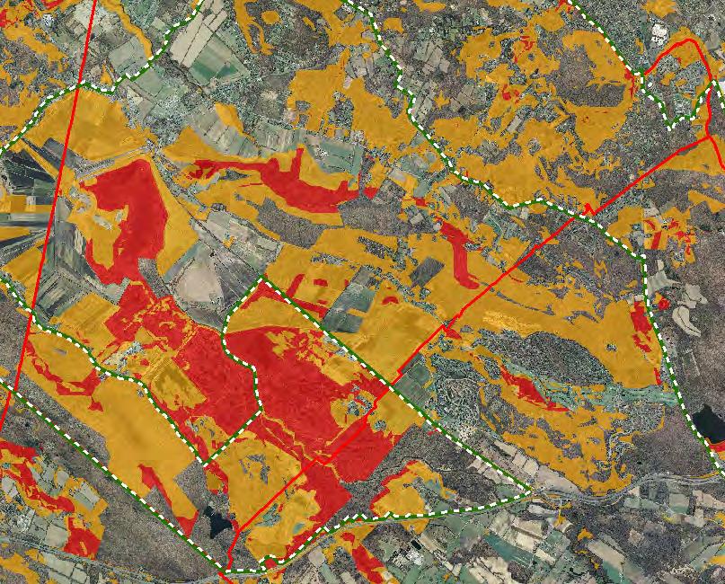
23 Figure 1: Municipal Build-out Report Septic System Yield by HUC14 and LUCM Zone * Potential Undevelopable Lands Conservation Zone Existing Community Zone Protection Zone HUC14 Subwatersheds Potential Oversized Lots in Conservation Zone in Existing Community Zone in Protection Zone in * Refer to Table 1 for Septic System Yield values, indexed by HUC14 ID HUC14 ID Number Potential Developable Lands in Conservation Zone in Existing Community Zone in Protection Zone in Miles Potential Redevelopable Lands in Conservation Zone in Existing Community Zone in Protection Zone in Preservation Zone Area
24 Roadway Network Interstate Highways U.S. Routes State Routes County Routes Local Routes
25 Hackettstown. '4 '4 '4 MOUNT OLIVE TOWNSHIP Rail Network Boonton Line Main Line & Bergen County Line Morris and Essex Line Raritan Valley Line Freight Rail Lines Freight Rail Lines Abandoned Freight Rail. Rail Stations '4 Park and Ride Sites Private Bus Lines NJ Transit Bus Lines p Airports

26 MOUNT OLIVE TOWNSHIP Conservation Easements Green Acres SADC Easements SADC Final SADC 8 Year SADC Preserved Preserved Lands Federal Open Space State Open Space County Open Space Municipal Open Space Non-Profit/Private Open Space Water Supply Watershed Lands Preserved Farmland
27 Conservation Prioirity Area Moderate High
28 MOUNT OLIVE TOWNSHIP Special Envrionmental Zones

29 SADC Easements SADC Final SADC 8 Year SADC Preserved Preserved Farmland Agriculture Uses


30 Important Farmland Soils Prime Farmland Farmland of Local Importance Farmland of Statewide Importance Farmland of Unique Importance

31 Agricultural Resource Area

32 Agricultural Priority Area Low Moderate High

33 Archaeological Grids (1 sqmi) NJ Historic Districts Historic Property Points Historic Property Polygons

34 MOUNT OLIVE TOWNSHIP Scenic Resources
35 State Planning Areas & Designated Centers 80 PA6 PA6 FRELINGHUYSEN TOWNSHIP PA4B PA5 80 PA5 PA4B PA5 tu 46 PA4B PA5 MOUNT OLIVE TOWNSHIP PA5 Æ 182 Legend State Planning Areas* METROPOLITAN (PA1) Interstate Highways U.S. Routes State Routes County Routes Designated Centers* SUBURBAN (PA2) FRINGE (PA3) RURAL (PA4) RURAL ENVIRONMENTALLY SENSITIVE (PA42) ENVIRONMENTALLY SENSITIVE (PA5) PARK (PA6) FEDERAL PARK (PA7) STATE PARK () WATER (PA11) MILITARY (PA12) * All designated centers expired on 1/7/2008 except Byram (expires 5/19/2010), Stanhope (expires 10/16/2008), and Sparta and Vernon (expire 7/16/2009). Center designation may be redesignated by the State Planning Commission and the Highlands Council. State Planning Areas are from the State Development and Redevelopment Plan Miles ±