Review of National Forestry Policies and Ongoing Forestry Programs in the Philippines
|
|
|
- Ilene Underwood
- 5 years ago
- Views:
Transcription
 4. Revised Master Plan for Forestry Development 5. Modes of Disposition and Management of Forestlands 6. Forestry Sector Programs 7.")
 Alienable or Disposable 14.2 M ha (47.32%) TOTAL 30.")
? Forest land with an area of more than 0.")
1 Review of National Forestry Policies and Ongoing Forestry Programs in the Philippines DENR-FMB Outline of Presentation 1. Land classification 2. Forest Cover 3. Sustainable Forest Management (SFM) 4. Revised Master Plan for Forestry Development 5. Modes of Disposition and Management of Forestlands 6. Forestry Sector Programs 7. FMB s involvement in CDM activities 1 2 Land classification refers to the legal classification of land; does not refer to the vegetative cover of the land Forestland 15.8 M ha (52.68%) Alienable or Disposable 14.2 M ha (47.32%) TOTAL 30.0 M ha (100%) A or D lands lands subjected to present land classification system and declared not needed for forest purposes Forestland lands subjected to present land classification system and determined as needed for forest purposes; for proclamation as forest reserves 3 4 WHAT IS A FOREST (IN THE CONTEXT OF LAND AND FOREST COVER)? Forest land with an area of more than 0.5 ha and tree crown cover (or equivalent stocking level) of more than 10%; trees able to reach a minimum height of 5 meters at maturity at situ; consists either closed or open forest formations Forest Management Bureau 5 6


 Forest Cover Within Forestland Area (M ha) % Within A & D Area (M ha) % Total Area (M ha) % Closed 2.481 34.61 0.080 1.12 2.561 35.73 Open 3.516 49.04 0.515 7.18 4.031 56.22 Mangrove 0.")
2 FOREST COVER CATEGORIES Closed Forest Closed Forest formation where trees in the various storeys and the undergrowth cover a high proportion (>40%) of the ground and without continuous dense grass layer; either managed or unmanaged, in advanced state of succession. Open Forest formations with discontinuous tree layer with coverage of 10 but less than 40%; managed or unmanaged, in initial state of succession. Mangrove forest forested wetland growing along tidal mudflats and along shallow water coastal areas extending inland along rivers, streams and their tributaries where the water is generally brackish; Plantations forest stands established by planting or/and seeding in the process of afforestation or reforestation 7 8 Mangrove Within Forestland 6.5 M ha (90%) Within A & D 0.7 M ha (10%) Forest Cover Within Forestland Area (M ha) % Within A & D Area (M ha) % Total Area (M ha) % Closed Open Mangrove Plantation Total Other Wooded Land Other Land: Built-Up Area Delineation, Classification and Demarcation of State Forestlands SUSTAINABLE FOREST MANAGEMENT EO 318 Other Land, Cultivated: Annual or Perrenial Cropland and Pastureland Incentives for Enhancing Private Investments, Economic Contribution and Global Competitiveness of Other Land, Natural: Forest-Based Industries Bare areas or Grassland 11 12


3 Sustainable Forest Management, Poverty Alleviation and Food Security in Upland Communities in the Philippines Sustainable Forest Management, Poverty Alleviation and Food Security in Upland Communities in the Philippines Major issues, problems and constraints 1. Inadequacies in policy and institutional arrangements 2. Program implementation problems 3. R & D, forest utilization and technology problems 4. Weak IEC and training 5. Lack of credible M & E system 6. Issues on CBFM, forestland boundary delineation, C & I, and resource accounting Expansion of forest cover through plantation establishment, enrichment planting and ANR 16 Sustainable Forest Management, Poverty Alleviation and Food Security in Upland Communities in the Philippines Sustainable Forest Management, Poverty Alleviation and Food Security in Upland Communities in the Philippines 2. Protection and improvement of the quality of natural forest stands 3. Enhancement of forest productivity and rationalization of forest-based industries 17 18

4 Sustainable Forest Management, Poverty Alleviation and Food Security in Upland Communities in the Philippines Sustainable Forest Management, Poverty Alleviation and Food Security in Upland Communities in the Philippines 4. Promotion of forest-based recreation, ecotourism and biodiversity 5. Increasing benefits from forests through proper planning of programs and strategies on forest development and conservation Major Challenge: Placing every hectare of forest areas under appropriate forest management systems and tenure Community-Based Forest Management Agreement Timber License Agreement Tree Farm Lease Agreement Agro-Forestry Farm Lease Agreement Integrated Forest Management Agreement Socialized Industrial Forest Management Agreement Forestland Grazing Management Agreement Special Land Use Permit/Lease Forest Land Use Management Agreement Forest Land Use Management Agreement Tourism Community-Based Forest Management Organized efforts to work with communities in and near public forestlands to protect, rehabilitate, manage, conserve and utilize the resource. Timber License Agreement (TLA) - privilege granted for utilization of forest resources with right of possession and occupation but with corresponding obligation to develop, protect and rehabilitate Existing: 5 Active: 14 Coverage: 639,709 ha Annual Cutting Area: 4,923 ha Annual Allowable Cut: 320,211 m 3 5,505 projects M ha 2,879 POs involved 690,791 households 5.97 M ha -CBFMP 1.62 M ha - CBFMA 23 24
5 Integrated Forest Management Agreement (IFMA), Socialized Industrial Forest Management Agreement (SIFMA) SIFMA privilege granted for development and management of up to 500 ha of forestlands into plantations 152 ITPLAs/IFMAs 680,480 ha 1,803 SIFMAs 34,727 ha Forestland Grazing Management Agreement (FLGMA) - formerly PLA/FLGLA, production sharing agreement on the development, management and utilization of grazing lands Special Land Use Permits/Leases - issued for all types of legal uses of forestlands other than production of timber and non-timber resources Now Forest Land Use Management Agreement (FLAg) & Forest Land Use Management Agreement-Tourism (FLAgT) 27 Forestry Sector Programs 28 MAJOR PROGRAMS Management of Forestlands and Forest Resources Forest Development Forest Protection Community Based Forestry Program Soil Conservation & Watershed Management Forest Boundary Delineation & Land Use Allocation 1. Management of Forestlands & Forest Resources Operation/Maintenance of Forestry Statistics Information System (FIS), C & I and other MAR Systems Issuance of Forestry Tenure Instruments Provision of technical assistance to NGOs, Pos, LGUs and other forest 29 30
 4.")


6 2. Forest Development Rehabilitation of degraded forest land Plantation maintenance & protection Seedling production 3. Forest Protection Protection of untenured Forestlands/Forest law enforcement/anti-illegal logging Strengthening Multi Sectoral Forest Protection Councils (MFPCs) 4. Community-Based Forestry Program Agroforestry development Construction of farm to market road in support to Hunger Mitigation Program Establishment of small water impounding structures Seedling production for distribution Establishment of barangay nurseries Provision of technical assistance to forest stakeholders Soil conservation & watershed management Watershed management thru the conduct of watershed characterization & preparation of integrated watershed management plan Implementation of watershed management interventions like the rehabilation & restoration of watershed areas 6. Forestland Boundary Delineation & Land Use Allocation Assessment & Delineation of Forestland boundaries Assessment of best land use of forestlands in support to sustainable upland development 33 a. POVERTY REDUCTION AND HUNGER MITIGATION b. SOCIO-ECONOMIC DEVELOPMENT c. NATURAL RESOURCES CONSERVATION d. CLIMATE CHANGE MITIGATION AND ADAPTATION MEASURES e. ENVIRONMENTAL EDUCATION AND ENFORCEMENT 34 POVERTY REDUCTION AND HUNGER MITIGATION UPLAND DEVELOPMENT PROGRAM (P2Billion Reforestation Program for 2009) REFORESTATION AND AGROFORESTRY AS TOOLS FOR: - SUSTAINABLE FOREST DEVELOPMENT - POVERTY REDUCTION - HUNGER MITIGATION - To be implemented by communities/peoples organizations in CBFM areas within priority watersheds 35 FOREST MANAGEMENT BUREAU S INVOLVEMENT IN CDM ACTIVITIES By virtue of DENR Administrative Order ( Rules and Regulations Governing the Implementation of Executive Order No. 320, Series of 2004, Designating the DENR as the National Authority for the Clean Development Mechanism. FOREST MANAGEMENT BUREAU was identified as the Technical Evaluation Committee (TEC) in-charge of evaluating all proposed CDM projects on afforestation and reforestation. 36
7 FOREST MANAGEMENT BUREAU S INVOLVEMENT IN CDM ACTIVITIES CDM TEC for A/R already established with the FMB Director as the Chair Guidelines governing the evaluation of CDM A/R project activities already issued (FMB Circular Reviewed one proposal already - Submitted by LLDA/NPC Maraming salamat po
8 BIOMASS ESTIMATION THROUGH DESTRUCTIVE SAMPLING Florencia B. Pulhin World Agroforestry Centre and Forestry Development Center, CFNR-UPLB Tools Needed 1.Field note 2.Meter tape 3.Compass 4.Diameter tape 5.Weighing g scale Steps 1.Select the dominant tree species 2.Select about 30 trees to represent the full range of diameter classes existing or expected but with a bias towards large trees 3.Measure dbh and height of each tree Steps 4. Harvest the selected trees to the ground using chainsaw. The tree must be felled at 0.3m from the ground. The undercut from the felled tree must be set aside for weighing as the weight of which must be included in the total weight of the felled trunk. Steps 5. Cut the trees into appropriate sizes for convenience of weighing. g Mark the felled trunk with cutting positions before cutting e.g. 1.3m, 3.3m, 5.3m ("1.3m" shall be marked at 1m from the cut bottom as the tree is felled at 0.3m from the ground). Mark also the position of each log on its surface to avoid errors in recording data. When cutting, the trunk must be cross-cut at the marked positions so that the diameter of the bottom end of each log can be measured accurately. Diameters at the big and small ends must be measured with and without the bark
9 All the boughs must be cleared off the felled trunk and the stump and collected for weighing g. Each log must be weighed and noted in the field ednote. Use of various spring scales according to the weight is advisable. Steps: 6. Collect a complete cross sectional sample of fresh wood from each log, estimate t the volume, ovendry it and measure the dry mass. Estimate t the density (g/cm3) by dividingidi the dry mass by its volume Add mass of trunk to mass of branches, leaves, etc to get total mass of the tree 7. Develop biomass equation through regression analysis 7. Estimate the biomass of the trunk using the formula: Biomass = volume x density Limitation Harvesting of 30 trees may not be feasible. Alternatively, Use mean tree biomass method Step s 1.Using dbh data from field measurements, prepare frequency table using appropriate class intervals e. g. 5 cm for each tree species 2.Locate the tree with a dbh close to the mean dbh value in the forest or plantation for each class.
10 Steps DBH Class Mean DBH (cm) > Harvest the selected tree and estimate the biomass using the method previously described 4.Estimate the total biomass of all tree in each dbh class using the biomass of the tree with mean dbh and the number of trees in the dbh class.


11
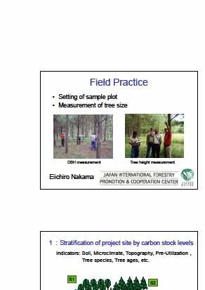
12 Tomorrow s Field Practices Tools and aids used Measuring Tapes (ordinary and diameter) Compass or Clinometers Numbering tape or markers Tape & poles (sticks) for plot boundary Recording paper and pencils Tree height meter Cutters for bush and tape Tomorrow s Field Practices Measurement of DBH within the plot 1: Selection of plot site (inside forest, one group is one plot) 2: Decision of plot size, a square, over the length of tree height each side (or one plot includes more than 30 trees) 3: Decision of plot boundary using compass and measuring tapes etc. 4: Decide plot area 5: Numbering of all trees inside a plot by marker and recording species and shapes of trees, if necessary 6: Measurement of DBH of all trees marked within the plot 7: Measurement of tree height for sample trees selected. Sample trees should be selected from a whole diameter range (n>10)


13
 (SV t+i -SV t )/i 7 2. Carbon stocks in BGB Indirect approach BGB is estimated by root to shoot ratio (R) (t d.m./t d.m.) BGB = AGB * R If root to shoot ratios for the species concerned are not available, project proponents shall use the allometric equation developed by Cairns et al.")
 & Table 3.4.")
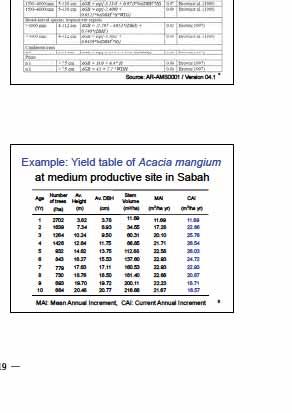
14 Example: Growth curve of Acacia mangium Growth curve Volume at a time(m 3 /ha SV, SV t+i CAI m 3 /hayr Current annual increment (SV + SV t )/1 MAIm 3 /hayr Mean annual increment) SV / PAI (Periodic annual increment) (SV t+i -SV t )/i 7 2. Carbon stocks in BGB Indirect approach BGB is estimated by root to shoot ratio (R) (t d.m./t d.m.) BGB = AGB * R If root to shoot ratios for the species concerned are not available, project proponents shall use the allometric equation developed by Cairns et al. (1997) BGB = exp{ * ln(agb)} BGB R AGB 8 Default values for Carbon stock estimation Basic rule: Use local or national values. If they are not available, appropriate values should be obtained from AGB for baseline; Table (tree) & Table (grass) in GPG AGB for living trees; Allometric equations in appendix C in AR-AMS0001, annex 4A.2 in GPG R for living trees & grassland; Table 3A.1.8 in GPG or equation in AR-AMS0001 WD for living trees; Table 3A.1.9 in GPG BEF for living trees; Table 3A.1.10 in GPG GPG: Good Practice Guidance for for Land Use, Land-Use Change and Forestry (LULUCF); IPCC (2003) 9 Relations; Living Biomass, carbon stock and CO 2 -equivalent CO 2 in atmosphere Photosynthesis H 2 O O 2 Living Biomass = Dry matter(t d.m.) Living Biomass (CH 2 O)n Dry matter (kg or ton) Carbon stock(tc) = Living Biomass(t d.m.) * Carbon fraction(cf) CO 2 -equivalent(tco 2-e ) = Carbon stock(tc) * 44/12(tCO 2 /tc) CF = Carbon stock (C) 10 Calculation sheet prepared by Bio-Carbon Fund Page 1 CO 2 removals per ha Router.cfm?Page=DocL ib&catalogid= Calculation sheet prepared by the Biocarbon Fund, World Bank for preparation of PIN of the proposed project CAI, PAIMAI m 3 /hay ton C/hay Default values WD: 0.5 BEF: 1.5 CF: 0.5 CO 2 /C: 3.67 R: 0.2 MS-Excel sheet and calculate automatically A g e Data CO2 removals tco2/ha y C removals tc/ha y C stocks tc/ha


15 Page 2 CO 2 removals per project 13