Lutsel K e. Community Wildfire Protection Plan
|
|
|
- Lauren Wright
- 5 years ago
- Views:
Transcription

1 Lutsel K e Community Wildfire Protection Plan Prepared for: Government of the Northwest Territories Environment and Natural Resources - Forest Management Division March 2012 Stew Walkinshaw, R.P.F. Canmore, AB. Phone: (403) montane@shaw.ca
2 Table of Contents 1 Introduction. 1 2 Planning Area Hazard & Risk Assessment Wildfire Ignition Potential 3.2 Wildfire Behaviour Potential 3.3 FireSmart Hazard Assessments 4 Vegetation Management Options Existing Vegetation Management 4.2 Proposed Vegetation Management 4.3 Vegetation Management Maintenance 5 Development Options Structural Options 5.2 Infrastructure Options 6 Public Education Options Interagency Cooperation and Cross-Training Options Emergency Planning Options Implementation Plan FINAL ii
3 1 Introduction The Lutsel K e Community Wildfire Protection Plan was developed to provide practical and operational wildland/urban interface risk mitigation strategies to reduce the threat of wildfire to developments within the community. The project objectives include: Assess and quantify community wildland/urban interface hazard and risk Based on interface hazard and risk: o Develop and prioritize fuel management and maintenance recommendations and prescriptions o Develop a summary of significant factors within the community that would enhance its exposure to wildfire and offer recommendations to reduce that threat. This Community Wildfire Protection Plan was developed using standardized FireSmart hazard assessment protocols and mitigative measures were developed based on the seven disciplines of wildland/urban interface approach and current research and knowledge in interface community protection. An implementation plan is included in this Plan to assist stakeholders to budget and complete projects based on the priorities identified. This plan should be reviewed and updated at five year intervals to ensure it is based on current conditions. 2 Planning Area and Stakeholders The planning area includes all lands within Lutsel K e and a two-kilometre buffer surrounding the community (Map 1). This includes the community, industrial area and airport, and the Frontier fishing lodge across the bay from the community. Stakeholders consulted with in the planning process included: Janice Ziemann, Forest Officer GNWT ENR North Slave Region Ray Griffiths, SAO Lutsel K e Tom Lockhart, RROII GNWT ENR Lutsel K e Land status authority is represented by the following (Map 1): Commissioner (GNWT MACA) Federal Indian Affairs Branch Mixed Private GNWT Crown lands (GNWT ENR) FINAL 1

4
5 3 Hazard & Risk Assessment The hazard and risk assessment process analyses the risk of wildfire ignition through analysis of fire incidence, the wildfire behaviour potential through analysis of fuels and weather data, and the values at risk to wildfire through FireSmart hazard assessments. 3.1 Wildfire Ignition Potential The assessment of recent fire incidence was completed using historical fire data from GNWT Environment and Natural Resources (ENR) for the ten-year period from 2002 to Fire incidence data indicates that 8 wildfires were discovered within a 10 kilometre radius of the community, 88% were human-caused and 12% were lightning-caused (Table 1). Two fires, one each from 1977 and 1978, escaped initial attack and reached approximately 40 hectares in size (Map 2). Table 1: Fire Incidence by Cause ( ) General Cause Number of Fires Percent of Total Human-Caused 7 88 Lightning-Caused 1 12 Totals The risk of wildfire in the planning area exists and most frequently occurs in areas accessible to residents and recreating public. FINAL 3

6
7 3.2 Wildfire Behaviour Potential Wildland Fuel Types Fire Behaviour Prediction (FBP) fuel types were used to analyze the fuel types and fire behaviour potential within and adjacent to Lutsel K e (Map 3). The planning area is dominated with boreal spruce (C-2) and mixedwood (M-1/M-2) deciduous (D-1) and mixedwood (M-1) with patches of spruce-lichen woodland (C-1), cured grass (O1), and deciduous (D-1) fuel types. The older western portion of the community and the airport are primarily non-fuel resulting in minimal hazard to structures located in those areas while the newer eastern portion of the main community is located in C-2 and M-1 fuel types resulting significant hazard to those structures Fire Weather Analysis Fire weather data from the Lutsel K e weather station was used to determine the predominant wind directions during the fire season. The predominant and strongest wind directions are from the north and northeast (Figure 1). Figure 1 Lutsel K e Windrose Wildland fuel types and fire weather data indicates that the predominant potential for wildfire exists in C-2 and M-1 fuel types to the east of Lutsel K e and in C-2 and M-1 fuel types immediately adjacent to developed areas in the eastern portion of the community. FINAL 5

8
.")

9 3.3 FireSmart Hazard Assessments FireSmart hazard assessments (P.I.P., 2003) were conducted on development areas and adjacent wildland fuel types within the planning area. Lutsel K e East and the Frontier Fishing Lodge are at the highest threat to wildfire (Table 2 & Map 4). Table 2: FireSmart Hazard Assessments Development Area Structure/Site Hazard (0 30m) Lutsel K e West Lutsel K e East Industrial Area ENR Firebase Airport Fishing Lodge Low High Moderate Moderate Low Extreme Hazard factor s for each of the development areas are discussed below. Lutsel K e West FireSmart hazard for Lutsel K e West is LOW. The area consists of the older residential and business portion of the community. Fuels primarily consist of non-fuel and cured-grass. Exterior structure materials are primarily asphalt shingle/metal with scattered wood shake roofing and wood, vinyl, or log siding. Access roads are all-weather loop design. Lutsel K e East FireSmart hazard for Lutsel K e East is HIGH. The area consists of the newer residential portion of the community. Fuels primarily consist of spruce and mixedwood. Exterior structure materials are primarily asphalt shingle or metal roofing and hardiplank or wood/vinyl siding. Access roads are all-weather loop and dead-end design. FINAL 7


10 Industrial Area FireSmart hazard for the Industrial Area is MODERATE. The area consists of the NWT Housing Corporation compound and the fuel tank farm. Fuels primarily consist of spruce and mixedwood. Exterior structure materials are primarily metal roofing and siding. Access roads are all-weather dead-end design. ENR Firebase FireSmart hazard for the ENR Firebase is LOW to MODERATE. Surrounding fuels primarily consist of open-density spruce and mixedwood. Access roads are allweather dead-end design. Airport FireSmart hazard for the Airport is LOW. Fuels primarily consist of non-fuel and cured grass with significant defensible space between the terminal and wildland fuels. Exterior structure materials are non-combustible roofing and siding. Access roads are allweather dead-end design. FINAL 8

11 Frontier Fishing Lodge FireSmart hazard for the Frontier Fishing Lodge is EXTREME. The facility consists of the main lodge and several cabins and outbuildings. Surrounding fuels primarily consist of spruce and mixedwood. Exterior structure materials are asphalt-shingle roofing and wood siding. Access is provided by boat from Lutsel K e. FireSmart hazard is High to Extreme for the newer Lutsel K e East residential area and the Frontier Fishing Lodge and Low to Moderate for the remainder of the community. FINAL 9

12

13 4 Vegetation Management Options The goal of vegetation management is to create a fuel-reduced buffer between structures and flammable wildland vegetation to reduce the intensity and rate of spread of wildfire approaching or leaving the development. Vegetation management options are proposed at the appropriate scale, based on hazard and risk, to reduce the threat of wildfire to developed areas. While fuel modification projects reduce the threat of wildfire to developments, they do not ensure structure survival under all hazard conditions. Vegetation management consists of one or any combination of the following options: Fuel removal Fuel reduction Species conversion Complete descriptions of the methods included in each of the above options are included in Fire-Smart Protecting Your Community from Wildfire (PIP 2003). FireSmart standards refer to three interface priority zones with vegetation management for interface structures recommended in Zones 1 and 2 at a minimum and in Zone 3 based on hazard and risk. Figure 3 Interface Priority Zones (PIP, 2003) FINAL 11
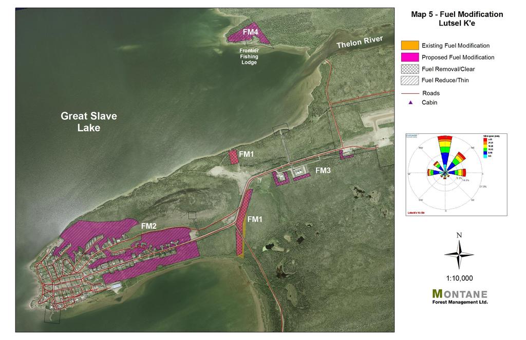
 Established East Fuelbreak 1980 s GNWT ENR Overgrown and ineffective 4.2")
14 4.1 Existing Vegetation Management The fuelbreak, constructed by ENR in the 1980 s, has been significantly overgrown and no longer acts as an adequate fuelbreak for the community (Table 3 & Map 5). Table 3: Existing Vegetation Management Areas Name Area Year Agency Comments (ha) Established East Fuelbreak 1980 s GNWT ENR Overgrown and ineffective 4.2 Proposed Vegetation Management Zone 1 Zone 1 vegetation management is inadequate for many of the residential structures, with a lack of defensible space from native grass fuels (O1) in the Luselk e West and from spruce fuels (C-2) in Luselk e East. FireSmart Zone 1 vegetation management options include: Removal of flammable forest vegetation within 10 metres of structures. Removal of all coniferous ladder fuels (limbs) to a minimum height of 2 metres from ground level on residual overstory trees. Removal of all dead and down forest vegetation from the forest floor. Increased maintenance to ensure that all combustible needles, leaves, and native grass are removed from on and around structures. Establishment and maintenance of a non-combustible surface cover around the structure including the use of FireSmart landscaping species. FINAL 12
15 Removal of all combustible material piles (firewood, lumber, etc) within 10 metres of the structure. For more information on FireSmart Zone 1 standards refer to FireSmart Protecting Your Community from Wildfire (PIP 2003). Recommendation 1: Encourage residents to establish adequate Zone 1 defensible space around their structures Zone 2-3 Priority areas are recommended for Zone 2-3 fuels management based on hazard and risk (Table 4 & Map 5). Proposed fuels management areas are conceptual at this time and will require detailed fuels reduction planning to identify fuels management prescription, unit boundaries, and operational constraints. Table 4: Priority Fuel Modification Areas Priority Area (Ha) Proposed Fuel Modification Standards FM1 East Fuelbreak FM2 Lutsel K e Community FM3 Industrial Area ENR Firebase FM4 Frontier Fishing Lodge Total Fuels Removal on old fuelbreak to clear re-growth to minimum 50 metre width Dispose of debris by piling and burning onsite or use as biomass or other product 25.4 Fuels Reduction by spacing spruce to 2-3 m crown spacing Remove all dead standing and dead & down coniferous and deciduous Retain deciduous overstory stems and willows for dust control Prune limbs to 2 metres Dispose of debris by piling and burning onsite or use as biomass or other product 1.4 Fuels Removal to remove an additional 25 metre width of fuels around the NWT Housing Corp, fuel tank farm, and ENR Firebase facilities Dispose of debris by piling and burning onsite or use as biomass or other product 2.9 Fuels Reduction by spacing spruce to 2-3 m crown spacing Remove all dead standing and dead & down coniferous and deciduous Retain deciduous overstory stems Prune limbs to 2 metres Dispose of debris by piling and burning onsite or use as biomass or other product Land Status Authority GNWT ENR GNWT ENR Indian Affairs GNWT ENR Commissioner Private GNWT ENR Recommendation 2: Zone 2-3 fuels reduction and maintenance is the responsibility of the Land Status Authority holder(s) and should be implemented based on the priorities identified in this plan. FINAL 13
16 4.3 Vegetation Management Maintenance Fuel modification area maintenance schedules depend on many factors including fuel type, soil and moisture conditions, and specific weather events. It is suggested that land managers provide periodic inspections of their fuel modification project areas and complete maintenance as required. It is projected that fuel modification maintenance will be required at least each five-year period. Recommendation 3: Ensure that all existing fuel modification projects are inspected on a regular basis and maintained as necessary to ensure fuel modification effectiveness. Maintenance should be the responsibility of the land manager or landowner. FINAL 14
17

18 5. Development Options Consideration of wildfire at the planning stage of new development is encouraged to ensure that wildfire hazard and appropriate mitigation measures are developed and implemented prior to development. New developments may overlap or conflict with existing fuel modification resulting in a reduction in fuelbreak effectiveness and an increase in wildfire threat to the new or existing development in the area. Recommendation 4: If a new development removes or reduces the effectiveness of any existing or proposed FireSmart mitigation measures or introduces new wildfire hazards, the area must be assessed and measures implemented to maintain the community protection standards. 5.1 Structural Options Structural characteristics that contribute to a structure s ability to withstand wildfire ignition include type of roofing and siding material, and proper construction and maintenance of eaves, vents, and openings that can accumulate flammable debris and allow wildfire to gain entry to the structure. The most common roofing materials in the planning area are asphalt shingle and metal with scattered structures with combustible wood-shake roofs, putting these structures at higher threat to airborne firebrand ignition. Siding materials vary between noncombustible hardi-plank and metal to combustible vinyl, wood, and log. Many structures have combustible debris piles (firewood, lumber, etc) immediately adjacent to the structure, increasing the threat of wildfire to the structure. FINAL 16
19 5.2 Infrastructure Options Infrastructure options include provision of adequate access standards to ensure quick and safe ingress and egress for residents and emergency responders during a wildfire, adequate and accessible water supply for structure protection and suppression, and utility installation standards that do not increase risk to emergency responders during a wildfire emergency Access Access road standards throughout the planning area are mainly adequate for an interface community. Most access roads are all-weather loop-road design and cul-de-sacs have adequate turnaround dimensions for fire apparatus. There is no road access to the community Water Supply Lutsel K e does not have municipal hydrant water-supply. All development areas rely on water-tender supply for structure protection activities. Each home is equipped with an inhouse water tank Franchised Utilities Franchised utilities affected by an interface fire include electrical power and heating fuels. Proper installation and maintenance of these services can minimize the risk to residents and emergency services personnel. Electrical Power Power distribution and residential service is provided through above-ground powerlines from the NWTPC generation plant. Some overhead distribution and service lines in the area are at risk to hazard trees which could result in wildfire ignition or downed lines during a wildfire. Heating Fuel Heating fuel is provided by tank supply. FINAL 17

20 6. Public Education Options Public education is a large part of the solution to success. Residents, landowners, municipal administration, and elected officials all need to be aware of the issues related to FireSmart development and the solutions to minimizing the risk and need to become a partner in implementation of the solutions in their communities. If stakeholders understand the issues relating to wildland/urban interface hazard they will be more likely to take action on their own property or to support actions taken by other authorities. Residents and stakeholders can refer to the GNWT ENR, Forest Management Division website at for further information on the GNWT FireSmart program, current wildfire updates, and other wildfire management related information. Key Messages FireSmart hazard assessments identified the need for the following key messages to residents. Development and maintenance of FireSmart Zone 1 defensible space surrounding the home, including: o Grass maintenance o Firewood and combustibles storage Recommendation 5: Public education on acceptable FireSmart Zone 1 standards is recommended for all residents. FINAL 18
21 7. Inter-Agency Cooperation and Cross-Training Options Interagency cooperation and cross-training between all stakeholders is necessary to ensure cooperative and effective implementation of wildland/urban interface mitigation options and to coordinate an effective response to a wildland/urban interface fire. Interagency stakeholders within the planning area include: Lutsel K e Dene First Nation GNWT Environment and Natural Resources (ENR) GNWT Municipal and Community Affairs (MACA) Frontier Fishing Lodge Recommendation 6: Develop a FireSmart Committee, consisting of all relevant stakeholders, to coordinate and lead the FireSmart program for the area. The Lutsel K e Fire Department presently has 5 or 6 members but is not active at this time therefore cross-training is not possible at this time. Should the fire department become active, cross-training for fire department members and ENR wildfire suppression personnel should include basic wildfire, wildland/urban interface fire, and incident command system training courses. The following cross-training courses are available. Wildland Fire Wildland Firefighter (NFPA 1051 Level I, S-100, or equivalent) Wildland/Urban Interface Fire Structure and Site Preparation Workshop (S-115) Fire Operations in the Wildland/Urban Interface (S-215) Incident Command System ICS Orientation (I-100) Basic ICS (I-200) Intermediate ICS (I-300) Advanced ICS (I-400) Recommendation 7: Should the fire department become active, the fire department and GNWT MACA & ENR should partner on cross-training initiatives to ensure emergency responders are cross-trained to the following minimum standards: Wildland Firefighter Structure and Site Preparation Workshop (S-115) Fire Operations in the Wildland/Urban Interface (S-215) Incident Command System (I-100 to I-400) as applicable FINAL 19
22 8. Emergency Planning Options The Lutsel K e Emergency Measures Plan is used to provide authority and direction during an emergency. At present the community does not have a wildfire pre-plan to provide emergency responders with detailed tactical information with respect to values at risk and operational strategies and tactics to minimize losses during a wildland/urban interface fire. A suggested pre-plan outline is as follows: Planning Area Jurisdictional Authority Values at risk (life, structures, infrastructure) Fire operations plan (strategies/tactics, water sources, equipment, communications plan) Recommendation 8: Develop a Community Wildfire Pre-Plan for the community to provide greater operational detail to emergency responders during a wildland/urban interface incident. FINAL 20
23 9 Implementation Plan The goal of the implementation plan is to identify the responsible stakeholders for each of the recommendations and set timelines for commencement and completion based on priorities and funding availability. Vegetation Management Zone 1 Issue Recommendation Responsible Agency Recommendation 1: Encourage residents to establish adequate Zone 1 defensible space around their Lutsel K e Dene FN structures. GNWT MACA Zone 2-3 Maintenance Recommendation 2: Zone 2-3 fuels reduction and maintenance is the responsibility of the Land Status Authority holder(s) and should be implemented based on the priorities identified in this plan. Recommendation 3: Ensure that all existing fuel modification projects are inspected on a regular basis and maintained as necessary to ensure fuel modification effectiveness. Maintenance should be the responsibility of the land manager or landowner. GNWT ENR & MACA Indian Affairs Frontier Fishing Lodge GNWT ENR & MACA Frontier Fishing Lodge Development Issue Recommendation Responsible Agency FireSmart Development Planning Recommendation 4: If a new development removes or reduces the effectiveness of any existing or proposed FireSmart mitigation measures or introduces new wildfire hazards, the area must be assessed and measures implemented to maintain the community protection standards. GNWT MACA Lutsel K e Dene FN Public Education Issue Recommendation Responsible Agency Public Education Recommendation 5: Public education on acceptable FireSmart Zone 1 standards is recommended for all GNWT ENR & MACA Priorities Lutsel K e residents. Lutsel K e Dene FN FINAL 21
24 Interagency Cooperation & Cross-Training Issue Recommendation Responsible Agency FireSmart Committee Recommendation 6: Develop a FireSmart Committee, consisting of all relevant stakeholders, to coordinate and lead the FireSmart program for the area. GNWT ENR & MACA Lutsel K e Dene FN Frontier Fishing Lodge Cross-Training Recommendation 7: Should the fire department become active, the fire department and GNWT MACA & ENR should partner on cross-training initiatives to ensure emergency responders are cross-trained to the following minimum standards: Wildland Firefighter Structure and Site Preparation Workshop (S-115) Fire Operations in the Wildland/Urban Interface (S-215) Incident Command System (I-100 to I-400) as applicable GNWT MACA & ENR Lutsel K e Dene FN Emergency Planning Issue Recommendation Responsible Agency Community Wildfire Recommendation 8: Develop a Community Wildfire Pre-Plan for the community to provide greater GNWT ENR & MACA Pre- Planning operational detail to emergency responders during a wildland/urban interface incident. Lutsel K e Dene FN FINAL 22