MARCELLUSBYDESIGN: PLANNING FORESTRY WITHIN THE MARCELLUS CONTEXT RYAN WALKER
|
|
|
- Edith Hopkins
- 5 years ago
- Views:
Transcription

1 MARCELLUSBYDESIGN: PLANNING FORESTRY WITHIN THE MARCELLUS CONTEXT RYAN WALKER
2 FORESTRY AND MARCELLUS GAS Residents in Maryland, Ohio, West Virginia, and Pennsylvania have experienced great economic benefit as a result of the development of and extraction from the Marcellus Gas play. However, this natural resource has had unwanted and unforeseen negative impacts on the landscape and small, rural communities, and pre-existing industries. In Pennsylvania, specifically the Northern Tier and western counties, Marcellus development is changing the landscape in much more visual and recognizable ways. In a region where forests have been a tradition in both the landscape and local communities, as well as a source for a timber industry that has been a national leader in timber production, continued Marcellus development will have a negative impact. This project looks at planning the landscape for both the Marcellus and timber industries needs as well as reconciling continued gas development with forest management and stewardship within Sullivan County Pennsylvania.

3 MARCELLUS CONTEXT The whole of Sullivan County lies within the Marcellus Shale play. As a result, gas companies have come to divide the county into separate lots for drilling and gas extraction. The Marcellus Shale play extends further west than east and the county is within the less productive eastern portion of the play. Some gas companies have begun to pull their operations out of eastern Pennsylvania, and Sullivan County, to areas further west. The western areas of the shale offer a more lucrative and productive gas resource. Eastern Pennsylvania shale gas is dry gas, natural gas that is composed mostly of methane gas. The western parts of Pennsylvania and the shale are considered wet gas, composed of more natural gases like ethane, methane, and propane. The multiple types of natural gas available further west is the main reason for the shift away from eastern Pennsylvania shale gas.


4 SULLIVAN COUNTY This info-graphic, and the one on the following page represent the economic and population comparisons for Sullivan County to the rest of the state. The county s small population and small average household income means that the influx of money produced by the Marcellus industry is going to have a very large impact on the residents of the county. As a result of this change to the county s landscape, population, and economy, many changes will require planning from local agencies and landscape architects.
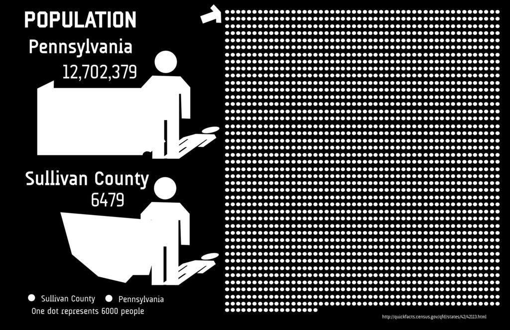
5
6 TIMBER AND FORESTRY Pennsylvania has a long tradition of logging and timber harvesting, one that goes back all the way to the beginning of the nation s birth. As a historical leader in the nation s timber production, Pennsylvania s woods have gone through many periods of logging, cutting, regeneration, and misuse. For Pennsylvania alone, the timber industry provides over 90,000 jobs in 2600 different companies, 10% of the state s manufacturing work. Private landowners also play an important role in the timber industry in Pennsylvania. Three quarters of forested land is owned by individuals and families, and that 75% provides 80% of timber products coming from Pennsylvania.

7 LAND CONVERSION Sullivan County is experiencing a loss of agricultural land that is, in most cases being converted into forested land. As projected by colleague Preston Linck, 81% of agricultural land is being converted to forested land in since 1925, much of this to forests. Agriculture Condition
8 FOREST MANAGEMENT With the majority of Sullivan County being comprised of forested land, and more acreage being converted from agricultural land, once fragmented woods lots and smaller forests will become larger, younger forests. Forest Condition
9 MARCELLUS DEVELOPMENT The current status of land use within the county determines that the majority of any future Marcellus development will happen within existing forests or newly converted agricultural land. Marcellus Condition
10 MARCELLUS OPERATION After the initial development of the pad, the pipe infrastructure and supporting equipment is removed from the site. The pad remains with the subgrade pipes still removing gas. The only remaining equipment is a small structure over the well opening that can only be seen when standing a few feet from it. Marcellus Condition
11 INFRASTRUCTURE IMPACT ON VISUAL QUALITY Pre-Marcellus Condition
12 INFRASTRUCTURE IMPACT ON VISUAL QUALITY Place image here 10 Year Development Condition Place image here
13 INFRASTRUCTURE IMPACT ON VISUAL QUALITY Although the equipment has been cleared off of the lower well pad, it is still in production. The drill rigs are only in operation at the start of the well s life in order to drill, frack, and start the extraction process. Well pads will look like this throughout their operational lifespan. 20 Year Development Condition
14 INFRASTRUCTURE IMPACT ON VISUAL QUALITY After the forty-year projected life span of a well, as projected by The Nature Conservancy, drilling has stopped and forested land continues to grow, but physical scars remain within the landscape, remnants of old well pads and roads. 40 Year Post-Marcellus Condition

15 MARCELLUS INFRASTRUCTURE No Marcellus Infrastructure The town of Laporte is the second largest town in the county and also has a lakeside community that is active in understanding the impacts that Marcellus gas is having on the environment around them. This forty-four square mile area around the town of Laporte has been used for a detailed scale of design and planning Marcellus Infrastructure within the forested area within the county. Areas in green are forested land, grey represents all other land use, Lake Mokoma is located to the right of the Laporte marker, and greenish-blue areas are wetlands.
16 This image cannot currently be displayed. MARCELLUS INFRASTRUCTURE Primary Infrastructure: Well Pads The dots scattered around the area of interest represent well pad locations; the dots in blue represent existing well pads while the red dots represent projected wells. These well pads are where the pipes are drilled into the ground and then drilled horizontally in order to maximize well pad production. The grey circles around the well locations represent a fiveacre well pad footprint, an average size for the operating area of a Marcellus drill. This five acres is cleared area where other mechanical equipment is housed onsite for use during construction of the drill rig. The well pad is the center of activity for Marcellus operations. Hundreds of trucks will come to each well pad during the beginning phases of production.
17 MARCELLUS INFRASTRUCTURE Secondary Infrastructure: Pipelines and Access Roads Although the majority of focus on Marcellus impacts revolves around the well itself and the well pads they operate on, the access roads and gathering pipelines play a significant part in land planning and design issues. The corridors cut through the landscape causing visual and physical changes to the landscape. The yellow line is the MARC-1 Pipeline, an interstate pipeline that is regulated by the Federal Energy Regulatory Commission. Red lines are proposed pipelines connecting the projected well pads. Black lines represent new access roads needed to service the projected well pads.

18 MARCELLUS INFRASTRUCTURE: PIPELINE CORRIDOR

19 DESIGN CONSIDERATIONS Aspects of the forest can be used as both an economic factor and a forest management factor in the design and planning of Marcellus infrastructure. In Northeast Pennsylvania, coniferous species have a much lower timber value. Wherever possible, pipeline corridors should be placed with coniferous areas in order to decrease the long-term economic value of timber resources. Species Type

20 DESIGN CONSIDERATIONS Pipeline Corridors can be used to serve several purposes. As well as the transmission right of way for gathering lines between well pads, these corridors can incorporate the necessary access rods to the well pads. These would be private access roads that the gas companies are responsible for both maintenance and safety. These roads could also be converted to forest access roads after the life of the Marcellus shale. Pipeline Corridor

21 DESIGN CONSIDERATIONS While new drill pads are beginning their drilling operations, hundreds of trucks will carry equipment, machinery, and water to the well pads. By keeping Marcellus trucks on these private access roads, conflict between public traffic and Marcellus traffic will be minimized as much as possible. Marcellus Truck Traffic


22 MARCELLUS INFRASTRUCTURE: PIPELINE CORRIDOR Even though the size of the pipe that goes into the ground is very small, the area of disturbance is quite large. In most cases, gas companies secure a 100 right of way for their pipelines. These right of way are often maintained by the gas companies so that they have easy access to their pipes. Instead of separating well pad or pipeline access roads from the pipeline corridors as is common practice now, placing the access roads within the right of way, parallel to the subgrade gas pipeline would mitigate more forest clearance and reduce traffic issues between gas companies and the public.
23 SUPPORTING MATERIAL: FOREST HEALTH AND VALUE

24 ANALYZING FORESTRY AND MARCELLUS GAS In order to understand the factors needed in planning forestry and timber within the context of the Marcellus Shale, two main considerations must be taken into account. First, understanding the economic impacts that the Marcellus industry will have on the timber industry in Sullivan County. This economic perspective will help drive design considerations that look to minimize the footprint of gas industry within the county. The second consideration is the health and management of forests as a result of continued Marcellus development. These considerations will look at managing forests immediately adjacent to new Marcellus infrastructure and how these management issues can be achieved while gas companies are operating within forested areas.

25 CALCULATING TIMBER VALUE County Timber Resources Despite being a smaller industry compared to the revenue produced by the Marcellus Industry, timber can produce a considerable amount of money. The industry standard for timber value is timber board feet, the amount of timber boards one foot long, one foot wide, and one inch thick from any timber log. For the planning purposes of this project, timber value is expressed in board feet per acre in order to provide both an economic and spatial context for timber harvesting. Unlike the natural gas found within the Marcellus Shale, the timber resources within Sullivan County are a renewable resource when managed properly. Calculating the value of all timber within the county shows the value of the resource available while showing the long-term economic impact due to Marcellus infrastructure that may be developed within the next forty years.

26 CALCULATING TIMBER VALUE Board Feet Production The United States Forest Service provides annual data on the nation s forest. According to the EVALidator Program, a database program run by the USFS, there is 251,275 acres of timberland. This number represents all areas that could be harvested for production. In order to determine a value for each of those 251,000 acres of land, the board feet production of timber from Sullivan County is taken and divided by the number of sawtimber acres. Those 251,000 acres produced a total of 1.5 billion board feet providing an average of roughly 6000 board feet per acre of timberland. * Retrieved and calculated figures are based on figures for


27 CALCULATING TIMBER VALUE Timber Value per Acre Using market data and a quarterly report produced by the Pennsylvania State University School of Forest Resources Cooperative Extension, an economic multiplier of $244 per thousand board feet is used to convert board feet per acre into value per acre. This multiplier is derived from an average of the eleven different species for the Northeast Region produced in the report. With a timber acre producing roughly 6000 board feet and a $244/1000 board feet multiplier, an average acre of timber in Sullivan County is worth $1450. This figure enables one to calculate the economic loss or gain of timberland in Sullivan County, in this case, the changes to timberland from Marcellus Infrastructure.

28 WELL PAD FOOTPRINT IMPACT

29 WELL PAD FOOTPRINT IMPACT Gathering Pipelines: Acres Along with projections for potential well pad locations, The Nature Conservancy projected that each new pad would require 1.6 miles of new gathering pipelines. The pipeline has a one hundred foot right of way, which multiplied by the length equals acres. Access Roads: 9.69 Acres Based on The Nature Conservancy s estimated 1.6 miles of gathering pipeline, the same distance is used for the calculations for access roads. With an access road typically fifty feet wide, the total acreage for serving one pad is 9.69 acres. Well Pad: 5 Acres A size of five acres is used for the size of the operating pad itself. Total Footprint: Acres
30 MARCELLUS INFRASTRUCTURE IMPACTS ON TIMBER PRODUCTION Unlike other counties in Pennsylvania that are sitting above the Marcellus Shale, Sullivan County has not developed drilling operations to a large degree to date. Of the two hundred and three active wells in the county, represented by the blue dots, only twenty-nine, or 14% are located within forested conditions. Projected wells are a completely different scenario. The Nature Conservancy projected 166 wells in forested locations that would require clearing. This is 86% of the 192 potential wells that could be developed within Sullivan County. With each well s footprint extending to 34 acres and the value being $50,000 these 166 wells would remove $8,300,000 in timber across the county. This added to the existing 29 wells' impacts reaches a total of $9,700,000 of timber lost to Marcellus development forest clearing.

31 ECONOMIC IMPACT PROJECTIONS 10-Year Economic Impact A typical well, serviced by a drill pad, access roads, and gathering pipelines in forested conditions equals roughly $50,000 in timber in one harvest year. The impacts to timber value are ones that occur on the same area of land over time. As wells continue to operate throughout their average 40-year life span, they are preventing the restocking of timber that could be harvested. 10-Year Marcellus Condition On average, each acre of timberland is restocking 126 board feet each year. 10 years of drilling activity would prevent $1,750,00 in timber from restocking on the 251,000 acres of forest land across Sullivan County.

32 ECONOMIC IMPACT PROJECTIONS 20-Year Economic Impact Although the visual changes to the landscape may be minimal, with more agricultural land being converted to forest, $3,500,000 of timber is lost by the time that wells have reached half of their operating expectancy. 20-Year Marcellus Condition
33 ECONOMIC IMPACT PROJECTIONS 40-Year Economic Impact 40-Year Marcellus Condition By the time that Marcellus wells have completed their operational lifespan, they have kept nearly 29,000,000 board feet from being restocked. Over this forty-year span, this will cost Sullivan County s timber industry $7,000,000. Under current regrowth statistics, the county would add a total of $77,000,000 in timber in the same forty year time frame. Across the county over that time, Marcellus Infrastructure would remove 20% of the timber that would be regrown without the Marcellus Industry being active in the county. As compared to the acreage added under current conditions, the county-wide forested land converted at the end of this forty-year development period is 5644 acres.

34 ECONOMIC COMPARISON There is a great economic comparison between the royalties produced by Marcellus wells and the economic value of the restock value of timber in the county over the lifetime of the wells. This infographic shows the relationship between how much money is made between timber and natural gas resources for the county. Marcellus wells are projected to produce $231.7 million in royalties while timber resources can produce only $7 million in the same amount of time.


35 SOCIAL AND ECONOMIC CONFLICTS Although it is true that the gas industry has brought money and wealth to many people in the county, the industry has also caused tension or conflict between neighbors, friends, and even family members. Depending on the negotiations during the signing of the lease, one land owner will be presented with a higher royalty per year based on the value of land identified by the gas companies. Here, the four rectangles represent four parcels of and owned by different individuals that are being drilled underground for natural gas. The landowner that has the well pad operating on his land will receive a much higher royalty payment compared to those landowners who have an access road or pipeline running on their land. Even though these three parcels of land are all being disturbed for infrastructure requirements, the amount of money received is extremely disproportionate.


36 FOREST MANAGEMENT, HEALTH, AND MARCELLUS GAS Even though the timber industry has been an economic factor in the Northern Tier counties, money from Marcellus gas leases and royalty payments has made the timber industry a secondary industry now. Little attention is being given to the timber when landowners can make up to ten times what they would normally make while still keeping their trees. This shift away from timber and forestry enables planners to look at the long-term health of the forests, the best ways to manage forests that have been influenced by Marcellus infrastructure, and suggest ways in which to protect this natural and aesthetic resource. The county is made of primarily deciduous and mixed forests. As mentioned before, these forested areas could face the majority of future Marcellus development and impacts.
37 PENNSYLVANIA ACT 13 REGULATIONS As Marcellus development started to grow across the state, largely with very little regulation at the beginning, environmental impacts and economic issues were starting to become more prevalent. The result was Pennsylvania Act 13, legislation that aimed at providing more regulation to stem these issues. Out of this legislation, distance buffers were set to define the location of where prospective location pads could or could not be located. This maps shows the Act 13 buffers for waterbodies and buildings, 300 and 500 respectively. The goal of these buffers is to mitigate sedimentation and erosion into the waterways and to keep well pads outside of municipalities.
38 PENNSYLVANIA ACT 13 DESIGN CONSIDERATIONS Although the Act 13 buffers are used towards new well pads, these buffers are used to inform the placement of new gathering pipelines. Wherever possible, new pipelines were planned to avoid these buffered areas. Unfortunately, not all the pipelines can avoid these buffers. The pipelines that cross into the 500 buffer for buildings will not have an environmental impact. In the cases where the pipelines cross a stream, the pipeline usually will be dug beneath the stream. The pipelines that cross into or through a stream buffer will require extra vegetative buffers in order to help mitigate any additional erosion into the stream.


39 PIPELINE CORRIDORS The access roads located within the pipeline were designed to fit within the 100 pipeline right of way, as demonstrated in the section image. The access roads connect directly to a state road in order to prevent significant road damage, which contributes to deteriorating conditions in the areas of forest immediately adjacent to the roads. Where access roads cannot link directly with a state road, existing local roads would have to be improved in order to handle the traffic of Marcellus trucks. These improved roads would also fall under the responsibility of the individual gas companies in order to maintain or repair any damage caused by their trucks.
40 REFERENCES EVALIDator. US Forest Service, Department of Agriculture. Version Revised October 29, Date Accessed 14 November College of Agricultural Sciences. Timber Harvesting in Pennsylvania: Information for Citizens and Local Government Officials. The Pennsylvania State University Jacobson, Mike and Kyle Kovach. Pennsylvania Woodlands Timber Market Report: Second Quarter 2012 April-June. The Pennsylvania State University School of Forest Resources Cooperative Extension Code 560: Conservation Practice Standard: Access Road. United States Department of Agriculture Maps and Graphics. Marcellus Center for Outreach and Research. The Pennsylvania State University Date Accessed 1 December Penn s Woods: The History of Pennsylvania s Forests. Pennsylvania Bureau of Forestry. Commonwealth of Pennsylvania Date Accessed 30 November Price, Will and Eric Sprague. Pennsylvania s Forests: How They are Changing and Why We Should Care. Pinchot institution for Conservation