Bushfire-Prone Area Assessment Report
|
|
|
- Milo Heath
- 5 years ago
- Views:
Transcription


1 Bushfire-Prone Area Assessment Report Brompton Lodge, Cranbourne 7 May 2013
2 Bushfire Prone-Area Assessment Report Brompton Lodge, Cranbourne Date of Inspection: 10 th April, 2013 Prepared For: Clients Name: Address: Karina Sunk Cnr Dandenong Hastings Road and Cranbourne Frankston Road, Cranbourne Telephone: Ecotide Pty Ltd ACN Hobson Street, Newport, Victoria 3015, Australia Ph: Mob: pbarnard@ecotide.com.au 2
3 Table of Contents Summary of Conclusions...4 General Terms of Engagement for Bushfire Property Assessment...5 Objectives of the Report...6 Locality, Site and Property Description...7 Description of landscape and surrounding vegetation...9 Category of Bushfire Attack Estimation for AS Vegetation Classification Distance to Classified Vegetation Assessment of Slope under the Classified Vegetation Bushfire Attack Level (BAL) Determination Potential Bushfire Attack Scenario Conclusions & Recommendations References Appendix 1 Photos of Site
4 Summary of Conclusions BUSHFIRE THREAT ASSESSMENT The development site is within a Bushfire Prone Area The predominant threat to the site is from patches of Scrub vegetation around the site. The site could be exposed to low to moderate intensity bushfire impact, including: o Radiant heat o Burning debris and embers CONCLUSIONS & RECOMMENDATIONS FOR THE DEVELOPMENT SITE The development of the site should be limited to a maximum of BAL Existing vegetation on the site will be removed or modified as part of the development. Any future reserves should be maintained in a low fuel state. BAL construction requirements of BAL 12.5 apply to the proposed development site. The applicable construction level must be met by any future development within the specified BAL area. Areas of the site (100 m or beyond from classified vegetation) that are not prescribed as BAL 12.5 will be BAL LOW and not have specific bushfire construction requirements. 4
5 General Terms of Engagement for Bushfire Property Assessment The general terms of engagement and conditions set out below apply to all work undertaken by Ecotide Pty Ltd in the general field of bushfire property assessments. Role of Ecotide Pty Ltd ECOTIDE PTY LTD will: Act in all professional matters as a faithful advisor to its clients. Exercise all reasonable skill and care in the provision of its professional services and shall abide by the codes of ethics or practice specified by the Environment Institute of Australian and New Zealand and other relevant professional bodies. Provide its services to clients effectively within the limitations imposed by the scope of work and budgets allocated by its clients. Role of the Client A client shall make available to ECOTIDE PTY LTD, as soon as practical after a commission has been awarded, all information, documents, maps and other particulars relevant to the subject commission. A client shall cooperate with ECOTIDE PTY LTD in all reasonable ways regarding in the conduct of a commission being undertaken on its behalf. Bushfire Property Assessment Reports ECOTIDE PTY LTD shall retain ownership of the reports, drawings, designs, displays and other work produced by ECOTIDE PTY LTD during the course of fulfilling a commission until final payment by the client. When the client pays for the services the client has read and FULLY understands: That managing the wildfire risk is a complex set of interrelated activities and environmental parameters and that the risk cannot be fully mitigated to their personal safety, family and assets. That even a well-planned, carefully constructed home with management of the surrounding vegetation can be vulnerable to wildfire. That survival in a wildfire is critically dependent on a combination of preparedness (competency) and activation of effective survival strategies and plans (capacity) of residents. That dwelling occupants should always develop a written wildfire survival plan. That the concepts and the contents of the report become their responsibility to implement. That the company (Ecotide Pty Ltd) is exempt from any liability now and into the future for any loss whatsoever resulting from the impacts of wildfire. 5
6 Objectives of the Report 1. Determine the bushfire hazards of the surrounding area, based on the vegetation and terrain. 2. Analyse the proposed development site in relation to the AS3959 methodology for assessing sites within bushfire-prone areas. 3. Provide recommendation on setback distances from bushfire hazards, water requirements and access requirements. 6

.")
.")
7 Locality, Site and Property Description Figure 1. Property location The site is located in Cranbourne within the City of Casey municipality, approximately 45 kilometres to the south-east of Melbourne. The region is characterised by residential development, along with remaining areas of agricultural land. The topography of the area is predominantly flat, with minor undulation. The site of the proposed development is at the corner of Dandenong Hastings Road and Cranbourne Frankston Road, Cranbourne (Figure 1). The property is currently a large area of open pastureland, zoned as Urban Growth Zone (UGZ). At present, a number of residential dwellings, sheds, and other facilities, including the Brompton Lodge Egg Farm, occur around the site. The site occurs on low, flat terrain surrounded by residential development, pastureland and golf courses (Figure 2). To the east, south and west is residential development at relatively low densities, typically featuring cultivated gardens. High density residential development occurs to the north-east of the site, associated with the Brookland Greens Estate. Bordering the site in the north is Ranfurlie Golf Club and a turf farm. Figure 2. Aerial view of site. 7

8 The proposal involves the potential residential development of the site area (Figure 3). This development will include high density residential properties, as well as associated road infrastructure, and public open space. Patches of remnant vegetation on the property will be retained in reserves on the site. Figure 3. Design response plan. 8

9 Description of landscape and surrounding vegetation The area around the site is generally characterised by open pastureland and residential development on relatively low, flat terrain (Figure 4). Much of the vegetation in the region has been cleared; however, small patches of remnant vegetation remain in isolated spots around the region. Figure 4. Topographical view of site The most significant vegetation in the region is within the Royal Botanic Gardens Cranbourne. This vegetation is beyond the assessment area, approximately 1.3 km to the east of the site. Closer to the site, patches of vegetation occur along Cranbourne-Frankston Road and Dandenong-Hastings Road. Unmanaged patches of vegetation occur on properties on the opposite side of Cranbourne-Frankston Road, to the south-east. These areas are all relatively small and isolated patches that are unlikely to pose a significant bushfire hazard to the proposal. Neighbouring properties to the west of the development, on the opposite side of Dandenong-Hastings Road, also feature patches of unmanaged remnant vegetation. The vegetation is patchy in its distribution, broken up by residences and cleared open space on flat terrain. The vegetation on the site itself can be described as managed grassland, with residential gardens expected to result as part of the development on the site. Linear patches of vegetation surrounding drainage areas and water bodies on the site are planned to be retained. Many of these areas are less than 20 metres in width. A protected aquatic habitat is planned near centre of the proposed development site. Associated vegetation will form a reserve that extends north-west along the drainage line. Another linear tree reserve will be retained on the property boundary that parallels Cranbourne Frankston Road. 9

10 Category of Bushfire Attack Estimation for AS A site inspection was undertaken on 10 th April 2013, using AS3959 (2009) assessment methodology to determine the potential bushfire risk for the proposed subdivision development. Areas on and surrounding the site were inspected to determine classifiable vegetation which may pose a significant bushfire risk to the future subdivision. Bushfire parameters were assessed at sampling points of classifiable vegetation (Figure 5). These include distance measurements from classifiable vegetation and slope under the vegetation. Using these inputs a corresponding Bushfire Attack Level (BAL) was determined to define setback distances from vegetation to the proposed development. Figure 5. Sampling points 10
.")
11 The Category of Bushfire Attack estimation is derived from the combination of the below: Vegetation Classification The vegetation has been classified as shown in Figure 6, and justified in Table 1. The vegetation classification is based on existing vegetation (at the time of inspection). It is expected that vegetation, particularly on the site (points 1-2, and 9), will be modified with future development (see Appendix 2). Figure 6. Classified vegetation around development site. 11
12 Table 1. Justification of vegetation classification. Sampling Point Aspect Classification Justification 1 South (on the property) Forest Trees between m in height Canopy cover between 30-70% Dominated by eucalypts 2 South-east (on the property) Forest Trees between m in height Canopy cover between 30-70% Dominated by eucalypts 3 South east Excluded 4 South Excluded 5 South-west Excluded 6 West Scrub 7 West Scrub Low threat vegetation a patch of pine trees with limited understorey between residential properties Single area of vegetation less than 1 ha in area and not within 100m of other areas of vegetation being classified (note: vegetation at samples 1 & 2 will be removed). Strip of vegetation less than 20 m in width and not within 20 m of other classified vegetation Trees greater than 2 m in height 10 30% foliage cover Trees greater than 2 m in height 10 30% foliage cover 8 West (on the property) Excluded Strip of vegetation less than 20 m in width and not within 20 m of other classified vegetation 9 (centre of the property) Scrub Trees greater than 2 m in height 10 30% foliage cover Dominated by eucalypt trees 10 North Excluded 11 North Excluded Strip of vegetation less than 20 m in width and not within 20 m of other classified vegetation Low threat vegetation as it is a managed golf course 12
13 Exclusions- Low threat vegetation and non-vegetated areas The Bushfire Attack Level shall be classified BAL- LOW where the vegetation is one or a combination of any of the following: a. Vegetation of any type that is more than 100 m from the site. b. Single areas of vegetation less than 1 ha in area and not within 100m of other areas of vegetation being classified. c. Multiple areas of vegetation less than 0.25 ha in area and not within 20 m of the site, or each other. d. Strips of vegetation less than 20 m in width regardless of length and not within 20 m of the site or each other, or other areas of vegetation being classified. e. Non-vegetated areas, including waterways, roads, footpaths, buildings and rocky outcrops. f. Low threat vegetation, including managed grassland, maintained lawns, golf courses, maintained public reserves and parklands, botanical gardens, vineyards, orchards, cultivated ornamental gardens, commercial nurseries, nature strips and wind breaks. 13

14 Distance to Classified Vegetation In order to determine the appropriate BAL category, the distances between the site and the classified vegetation must be determine. Distances from the border of the development property to the edge of the classified vegetation were determined using satellite imagery. These distance measurements, associated with the classified vegetation, are summarised below. Table 2. Summary of classified vegetation sampling points and the distances to the property boundary. Sampling Point Line of Sight Measured from Distance from site to the edge of the vegetation N/A (vegetation on property) N/A N/A (vegetation on property) N/A West edge of property 50 m (Figure 8) West edge of property 51 m (Figure 8) N/A (vegetation on property) N/A Figure 7. Distance measurement from classified vegetation (6 and 7) in the west to property boundary. 14

15 Assessment of Slope under the Classified Vegetation The slope was measured under the classified vegetation at the time of inspection. The results of these measurements are summarised below. Measurements taken at sampling points 1 and 2 have been averaged to provide the average slope under this strip of classified vegetation. Table 3. Summary of the slopes under the classified vegetation sampling points. Sampling Point Average Slope 1 Upslope Flat 7 Flat 9 Flat The below figure shows the mapping of these slopes under the classified vegetation. Figure 8. Average slope values under the classified vegetation. 15
16 Bushfire Attack Level (BAL) Determination The Bushfire Attack Level is determined by comparing the sampling data (slope, vegetation classification, setback distance) on Table of the Australian Standard A summary of this table is shown below. Figure 9. BAL categories and setbacks with setbacks relevant to site highlighted. Note: equal to or beyond 100 m is BAL LOW. Using this table, we are able to determine the setbacks and BAL categories that apply to the site. These are summarised below for each area of classification vegetation. Table 4. Summary of sampling points, parameters and resulting BAL setbacks. Sampling Point 1 2 Vegetation Classification Average Slope Distance from site to veg. BAL 19 BAL 12.5 Forest Upslope 2 N/A (on site) 35 - <48 m 48 - < 100 m 6 Scrub Flat 50 m 19 - <27 m 27 - < 100 m 7 Scrub Flat 51 m 19 - <27 m 27 - < 100 m 9 Scrub Flat N/A (on site) 19 - <27 m 27 - < 100 m Note: equal to or beyond 100 m is BAL LOW. The BAL setback distances are based on the distance between the edge of the vegetation and the building envelope of a residential dwelling. A BAL- 19 is prescribed as a maximum BAL level to sections of the subdivision due to the significant cost requirements involved with higher levels of construction. A maximum level of BAL 19 is also in line with similar requirements applied to subdivisions within the Bushfire Management Overlay. 16

17 The appropriate setbacks have been modelled on the proposed layout for the site in Figure 11. This provides an indication of the areas affected by the BAL 19 and BAL 12.5 construction requirements. Unmarked areas of the subdivision would be prescribed BAL LOW. Figure 10. Modelling of BAL construction requirements on the subdivision plan overlay. Sampling points 1-2, and 9 will not require BAL setbacks due to the proposed modification as part of the development of the site. 17
. www.ecotide.com.")
18 The BAL construction areas relating to vegetation patches in the area are also depicted in Figure 11 to provide further detail. Figure 11. BAL 12.5 construction area in relation to the west of the site (sampling points 6 and 7). 18
19 Potential Bushfire Attack Scenario As a general description of fire history, the urban-rural interface of Melbourne s south-east, including Cranbourne, exhibits the typical fire weather patterns of south-eastern Australia. Fire weather days usually consist of north-west winds (generated by hot dry north winds from the inland) followed by a later southwest wind change in the afternoon. This is classically depicted in the weather pattern experienced on 16th February 1983 in the Ash Wednesday fires and is again the most likely weather scenario posing a threat to the area on severe fire weather days. The most significant bushfire hazard in the region is the vegetation on the grounds of the Royal Botanic Gardens Cranbourne (RGBC). Significant management does occur at the RBGC, however, and the vegetation is located over 1 km to the east of the site. It is unlikely that an uncontrolled fire in this area would impact directly on the site. Relatively small patches of vegetation that exist along Dandenong-Hastings Road and Cranbourne-Frankston Road present lower threat bushfire hazards. These areas could be ignited through spotting or other means. The terrain under the vegetation is unlikely to factor significantly into the bushfire behaviour, with the fire s advancement most likely to be wind-driven. For the scrub vegetation to the west of the site, a north-westerly or south-westerly scenario could direct the fire towards the site. The scrub vegetation could burn rapidly, although the fire is likely to be limited in duration and intensity by the size of the vegetation patches. Furthermore, Dandenong-Hastings Road would act as a buffer for the development from fire impact. It is estimated that, based on the existing separation of the vegetation from the site, that any dwellings built on the property could be exposed to relatively low levels of radiant heat and ember deposition. Existing vegetation on the site is expected to be removed or modified following development of the site. These areas are therefore not expected to pose a bushfire threat to future residences on the site. Development in neighbouring areas around the site can generally be described as cultivated gardens that will be maintained in a low fuel state. It is unlikely that these areas will pose a significant bushfire hazard to the site. 19
20 Conclusions & Recommendations 1. This area is within a Bushfire Prone Area, which could be subject to bushfire impact. 2. Existing vegetation on the site will be removed or modified following development of the site, and must be maintained in a low fuel state. 3. The particular site could be impacted from relatively localised, smaller fires in patches of vegetation around the site. 4. There is the potential for low to moderate bushfire impact at the urban interface for radiant heat effects and, further into the development site, impacts from ember deposition. 5. The development of the site will assist in filling in the undeveloped areas of Cranbourne with residential development. 6. It is recommended that development on the site be to a maximum level of BAL 12.5 in relation to the classified vegetation in the area and on the site. 7. Significant reserves on the development site have not been analysed as part of the bushfire assessment as these will be removed or modified with development of the site. 8. BAL construction requirements must be met for development within the prescribed BAL areas. 9. Development areas beyond 100 m from classified vegetation will be assigned a BAL LOW, and will therefore not have specific bushfire construction requirements. 10. It is recommended that future property owners formalise a written a bushfire survival plan for all occupants. 20
21 References [1] Australian Standard - Construction of buildings in bushfire-prone areas-as [2] Map courtesy of [3] Satellite Image of property, courtesy of Google Earth [4] Basic Property Report 21

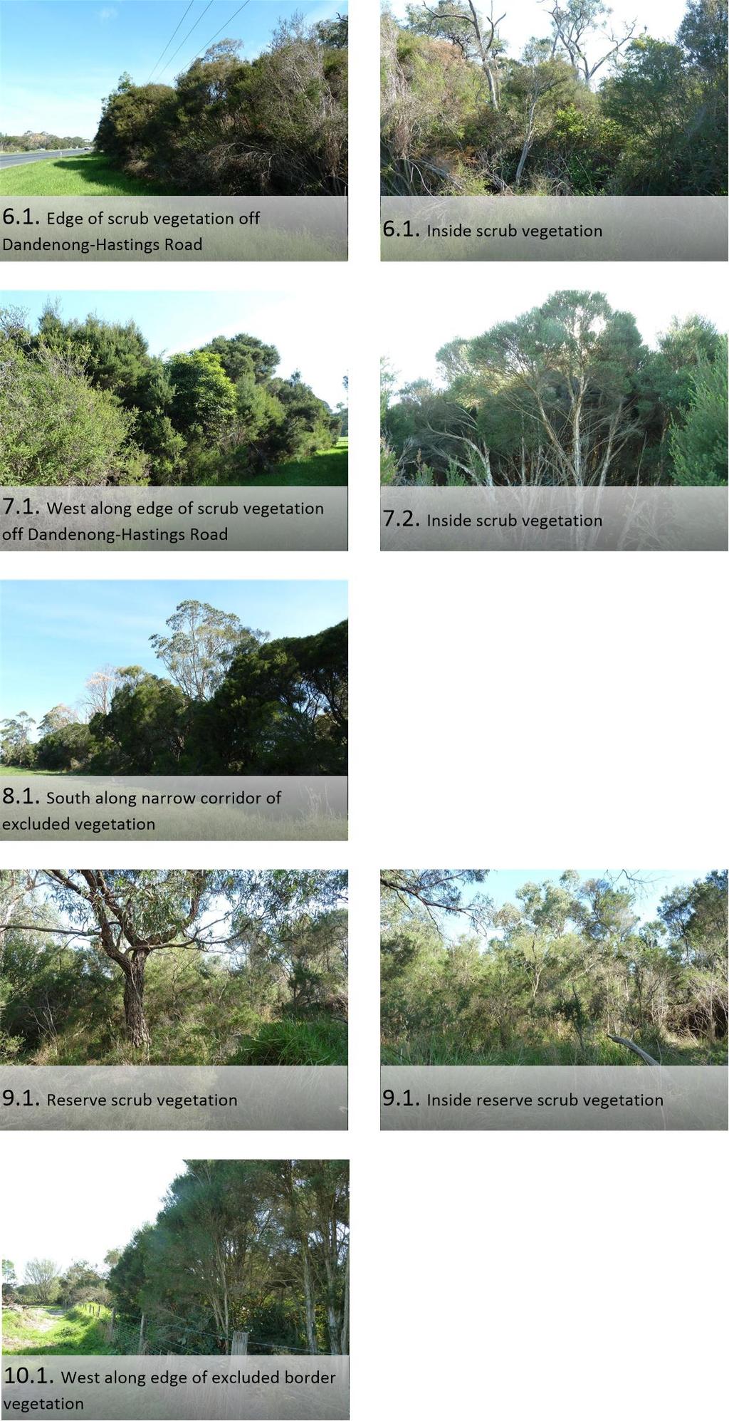
22 Appendix 1 Photos of Site See following corresponding labelled photos. 22

23 23
24 24


25 Appendix 2 Vegetation Modification on the Site Documents provided by client indicating proposed vegetation modification areas on site as part of the development proposal. Vegetation modification along southern boundary of the site: Vegetation modification on remnant vegetation on the site: 25