Preliminary Investigation of Waters of the United States Noble County Impoundments 1 and 4. Prepared for: CONSOL ENERGY
|
|
|
- Charles Nelson
- 5 years ago
- Views:
Transcription


1 Preliminary Investigation of Waters of the United States Noble County Impoundments 1 and 4 Prepared for: CONSOL ENERGY Prepared by: ms consultants, inc. engineers, architects, planners Akron, Ohio October 2013
2 Noble County Impoundments 1 and 4 WOTUS Report Preliminary Investigation of Waters of the United States Noble County Impoundments 1 and 4 Introduction Prepared by: ms consultants, inc. engineers, architects, and planners 1 South Main Street Akron, Ohio October 2013 CONSOL Energy/CNX Water Assets LLC is evaluating various locations for water impoundments for potential energy development activities being considered in Noble County. Several potential sites have been identified (see Figure 1). This Waters of the United States Report has been prepared in order to identify potential development constraints (waterway permit issues) for potential impoundment sites 1 and 4. For the two potential impoundment sites, a buffer around the site was identified, and water resources (wetlands and streams) were delineated within and immediately adjacent to this buffer zone. Literature Review Soils Data Soils data for the project site was obtained from the Ohio Department of Natural Resources OGRIP database, and is shown on Figures 2 and 3. Soils data were compared to the list of Hydric Soils for Noble County obtained from the USDA Natural Resources Conservation Service database. The presence of hydric soils is considered a prime indicator of the possible presence of wetlands. The hydric soil list for Noble County indicates that there are no identified hydric soil classifications in the County (see Attachment 4). Soil types identified in the project study areas include: Impoundment Site #1 (Figure 4) o LoD Lowell silt loam, 15-25% slope o DkF DeKalb channery loam, 40-70% slope o ZaC Zanesville silt loam, 6-15% slope o GdC Gilpin silt loam, 8-15% slope o UpB Upshur silt loam, 3-8% slope o LuE Lowell-Gilpin silt loam, 25-35% slope Impoundment Site #4 (Figure 5) o BtE2 Brookside Vandalia complex, 25-35% slope, eroded o No Newark silt loam, occasionally flooded o BkF Berks shaly silt loam, 35-70% slope o LuE Lowell-Gilpin silt loam, 25-35% slope
3 Noble County Impoundments 1 and 4 WOTUS Report According to the Noble County Soil Survey, none of the mapped soils are considered as hydric or as having hydric components. The soil information does not suggest a high potential for wetlands in any of the pond buffer areas. National Wetland Inventory The National Wetland Inventory (NWI) was prepared by the U.S. Fish and Wildlife Service using aerial photo interpretation, and is a general indicator of the possible presence of wetland areas. The NWI locations for the two project areas are shown on Figures 4 and 5. The NWI mapping shows no wetlands within the study areas for Impoundments 1 and 4. The NWI is only a general indicator, and the actual presence or absence of wetlands should be confirmed by a site investigation. Ohio Wetland Inventory The Ohio Wetland Inventory (OWI) was prepared by the Ohio Department of Natural Resources using aerial photo interpretation, and is a general indicator of the possible presence of wetland areas. The OWI locations for the two project areas are also shown on Figures 4 and 5. The OWI mapping shows no wetlands within the study areas for Impoundments 1 and 4. The OWI is only a general indicator, and the presence or absence of wetlands must be confirmed by on-site investigation. Watershed The two study areas are located within the East Fork Duck Creek, headwaters to below Elk Ford watershed (HUC ). Site Visit Site Visit - The project site visit was conducted by ms consultants staff on October 3, All potential wetland areas within or near the study areas were identified and mapped using GPS methods. Efforts were also made to identify any possible stream channels within the buffer areas. The findings of the visit were as follows: Site No. 1 Site No. 1 is located off of Cowgill Road (latitude , longitude , see Figure 6). The site is abandoned pasture and fallow fields. Dominant species include goldenrods (Solidago spp.), broomsedge grass (Andropogon sp.), New York and New England asters (Aster spp.) and fescue grass cover. No wetlands or streams were identified within the project study limits. One wetland was noted adjacent to Donald Franklin Road (T-215), but this wetland is outside of the project study limits. The tree rows running east-west exhibited potential for Indiana bat habitat, with large, dead trees. Species include hickory (Carya spp.), locust (Robinia spp.), and ash (Fraxinus spp.). If these trees must be cleared, they should be cut in accordance with U.S. Fish and Wildlife avoidance measures. In general, trees may be cut between September 15 and April 15. Site No. 4 Site No. 4 is located along Doshie Road (latitude , longitude , see Figure 7). The site is characterized as upland abandoned field, with the same species as Site No. 1. Shrub and small tree cover included multi-flora rose (Rosa sp.), osage-orange (Maclura sp.), and hawthorne (Crataegus sp.). One perennial stream is located along the far eastern study area edge, draining from north to south. One intermittent stream is located mid-study area. The main stream branch is located at the southwest corner of the study area. Based on the preliminary site layout, no impacts on these streams are anticipated. No wetlands were identified within the study area. On potential wetland was investigated in the western portion of the study area, but it was
4 Noble County Impoundments 1 and 4 WOTUS Report determined that this site does not meet the jurisdictional wetland criteria. The location of the data point is shown on Figure 7. Discussion The fieldwork indicates that there are no jurisdictional or isolated wetlands within the study areas for Impoundments No. 1 and No. 4. The wetland boundaries are not official until the Army Corps of Engineers completes a Jurisdictional Determination for the site. Encroachment (placement of fill) on jurisdictional wetlands would require permit coordination with the U.S. Army Corps of Engineers, Huntington District. The literature resources and fieldwork suggest the presence of stream channels within the study areas. The preliminary plans indicate that there would be no encroachment on these stream channels. Encroachment on the streams (fill within the Ordinary High Water Mark) would require permit coordination with the U.S. Army Corps of Engineers, Huntington District. The tree rows running east-west on Site No. 1 exhibited potential for Indiana bat habitat, with large, dead trees. If these trees must be cleared, they should be cut in accordance with U.S. Fish and Wildlife avoidance measures. In general, trees may be cut between September 15 and April 15.
5 Noble County Impoundments 1 and 4 WOTUS Report Attachment 1 Figures
6 15) SHELTON (T-207) WOODSFIELD (S-78) SULLIVAN (T-554) ZEP (S-146) "6 "6 STEAM TOWN (T-210) MCVICKE R (T-42) RAYMOND HILL (T-209) BARNES RIDGE (C-51) R R GANT (T-1103) DONALD F RANKLIN (T-2 DOSHIE (C-6) COWGILL (C-4) (T-142) WATSON MARION FREDERICKSDALE (C-211) CENTER NBL39 Site #1 Site #4 NOBLE COUNTY NBL27 Site #6 I 0 1,000 2,000 Feet Site #5 STOCK "6 Existing CNX Well Pads oh14dig New Potential Impoundment Sites Potential Impoundment Footprints Potential Impoundment Sites (CNX Held Property) Consol Energy Surface Holdings Potential Impundment Sites (not CNX Held Property) Figure 1 - Overview of Preferred Impoundment Areas ZEP (S-146)
7 NOBLE COUNTY DkF LoD LoD COWGILL (C-4) DONALD FRANKLIN (T-215) WATSON (T-142) DkF UpB ZaC CENTER WoC "6 NBL39 LvD2 LoD MARION DkF LuE LoD WoC GdC LuF Ch GdD "6 Existing CNX Well Pads New Site 1 Option Potential Impoundment Footprints Potential Impoundment Sites (CNX Held Property) Consol Energy Surface Holdings GuC LuF BsD2 BsD2 GuC I Feet Potential Impoundment Site #1 Figure 2 - Soils LoD
8 NOBLE COUNTY DONALD FRANKLIN (T-2 DkF LoD LuF COWGILL (C-4) DkF "6 Existing CNX Well Pads New Site 4 Option Potential Impoundment Footprints Potential Impoundment Sites (CNX Held Property) Consol Energy Surface Holdings LoD Noble County Water Main Lines LuF 15) LoD LuF LuE BtD2 MARION BkF BtE2 DOSHIE (C-6) FREDERICKSDALE (C-211) RAYMOND HILL No BtD2 (T-209) BkF GuC LuF LpE2 RAYMOND HILL (T-209) I Feet Potential Impoundment Site #4 Figure 3 - Soils
9 NOBLE COUNTY COWGILL (C-4) PUBGh DONALD FRANKLIN (T-215) CENTER WATSON (T-142) "6 NBL39 MARION "6 Existing CNX Well Pads Streams New Site 1 Option Potential Impoundment Footprints Potential Impoundment Sites (CNX Held Property) Potential Impundment Sites (not CNX Held Property) Consol Energy Surface Holdings National Wetland Inventory Ohio Wetland Inventory Open Water Shallow Marsh Shrub/Scrub Wetland Wet Meadow I Feet Potential Impoundment Site #1 Figure 4 - Ohio and National Wetland Inventory
10 LIN (T-215) NOBLE COUNTY DONALD FRANK COWGILL (C-4) PEM1A PUBGx MARION DOSHIE (C-6) FREDERICKSDALE (C-211) RAYMOND HILL (T-209) PUBGx "6 Existing CNX Well Pads National Wetland Inventory Ohio Wetland Inventory Streams Open Water New Site 4 Option Shallow Marsh Potential Impoundment Footprints Shrub/Scrub Wetland Potential Impoundment Sites (CNX Held Property) Wet Meadow Consol Energy Surface Holdings Noble County Water Main Lines PEM1A RAYMOND HILL (T-209) PUBGh I Feet Potential Impoundment Site #4 Figure 5 - Ohio and National Wetland Inventory
11 NOBLE COUNTY WATSON (T-142) COWGILL (C-4) DONALD FRANKLIN (T-215) Potential Bat Trees MARION Wetland New Site 1 Option Potential Impoundment Footprints Consol Energy Surface Holdings Potential Impoundment Sites (CNX Held Property) Wetland_Site1_Poly Potential Bat Trees Streams I Feet Potential Impoundment Site #1 Figure 6 - Ecological Resources
12 NOBLE COUNTY DONALD FRA NKLIN (T-215) COWGILL (C-4) Perennial Stream Intermittent Stream!. MARION DOSHIE (C-6) FRE DERICKSDALE (C-211)!.!. RAYMOND HILL Data Point Main stream branch (T-209)!. Stream Streams New Site 4 Option Potential Impoundment Footprints RAYMOND HILL (T-209) Potential Impoundment Sites (CNX Held Property) Consol Energy Surface Holdings Noble County Water Main Lines I Feet Potential Impoundment Site #4 Figure 7 - Ecological Resources
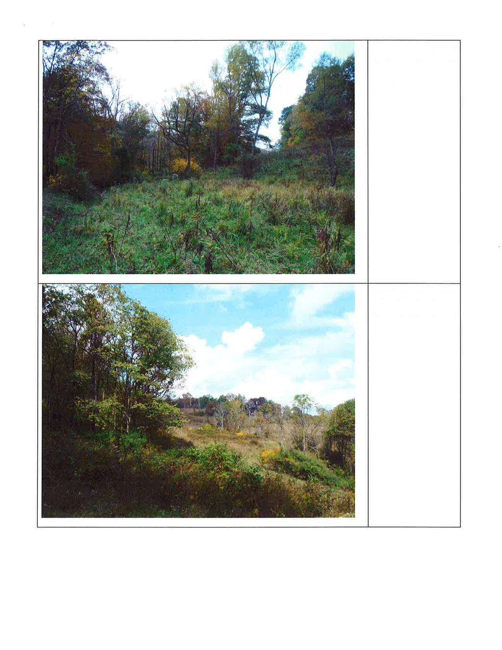
13 Noble County Impoundments 1 and 4 WOTUS Report Attachment 2 Photos


14


15

16

17
18 Noble County Impoundments 1 and 4 WOTUS Report Attachment 3 Noble County Hydric Soils List
19 Hydric soils list for Noble County Page 1 of 1 U.S. DEPARTMENT OF AGRICULTURE PAGE 1 NATURAL RESOURCES CONSERVATION SERVICE 03/02/00 NOBLE COUNTY, OH HYDRIC SOILS LIST MAPUNITS WITH HYDRIC COMPONENTS Mapunits are listed in alpha-numeric order by mapunit symbol. The "Hydric Soils Criteria" columns indicate the conditions that caused the mapunit component to be classified as "Hydric" or "Non-Hydric". These criteria are defined in "Hydric Soils of the United States" (USDA Miscellaneous Publication No. 1491, June, 1991 as revised in the Federal Register, Vol. 60, No. 37, February 24, 1995). See the "Criteria for Hydric Soils" endnote to determine the meaning of these columns. Spot symbols are footnoted at the end of the table. Hydric Soils Criteria Map Symbol Component(C)/ Mapunit Name Inclusion(I) Hydric Local Hydric Meets Meets Meets Landform Criteria Saturation Flooding Ponding Code Criteria Criteria Criteria NO HYDRIC MAPUNITS FOOTNOTE: There may be small areas of included soils or miscellaneous areas that are significant to use and management of the soil; yet are too small to delineate on the soil map at the map's original scale. These may be designated as spot symbols and are defined in the published Soil Survey Report or the USDA-NRCS Technical Guide, Part II. U.S. DEPARTMENT OF AGRICULTURE PAGE 2 NATURAL RESOURCES CONSERVATION SERVICE 05/22/98 1. All Histosols, except Folists, or HYDRIC SOILS CRITERIA CODES AND DEFINITIONS 2. Soils in Aquic suborders, great groups, or subgroups, Albolls suborder, Aquisalids, Pachic subgroups, or Cumulic subgroups are: a. Somewhat poorly drained with a water table equal to 0.0 foot (ft) from the surface during the growing season, or b. Poorly drained or very poorly drained and have either: (1) water table equal to 0.0 ft during the growing season if textures are coarse sand, sand, or fine sand in all layers within 20 inches (in), or for other soils (2) water table at less than or equal to 0.5 ft from the surface during the growing season if permeability is equal to o greater than 6.0 in/hour (h) in all layers within 20 in, or (3) water table at less than or equal to 1.0 ft from the surface during the growing season if permeability is less than 6.0 in/h in any layer within 20 in, or 3. Soils that are frequently ponded for long duration or very long duration during the growing season, or 4. Soils that are frequently flooded for long duration or very long duration during the growing season. 5/23/03