REPORT Meeting Date: Regional Council
|
|
|
- Karen French
- 5 years ago
- Views:
Transcription

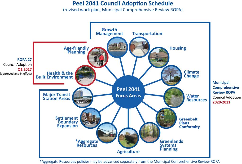
1 8.2-1 REPORT Meeting Date: Regional Council DATE: April 10, 2018 REPORT TITLE: FROM: Janette Smith, Commissioner of Public Works RECOMMENDATION That Regional Council recommend to the Provincial Government that the draft Provincial guidance on Municipal Comprehensive Reviews be revised to allow flexibility for a staged implementation of Official Plan Amendments undertaken in a manner that continues to provide for an integrated approach to planning for complete communities such as the approach currently underway in the Region of Peel. REPORT HIGHLIGHTS This report provides an overview of the current Provincial planning framework in place including the 2017 Growth Plan, Bill 139 implementing Ontario Municipal Board reform as well as emerging guidance on land needs assessment, Municipal Comprehensive Review requirements, Provincial mapping and application of targets. The 2017 Growth Plan came into effect on July 1, 2017, providing forecasts to 2041 and a new expanded policy framework for Municipal Comprehensive Reviews which now must be initiated by the Region and approved by the Province. Previously, Municipal Comprehensive Reviews applied only to employment conversions and settlement boundary expansions, could be initiated by local municipalities and did not require Provincial approval. The expanded Municipal Comprehensive Review policies require integrated planning to 2041, addressing a provincially mandated land needs methodology, built up areas, major transit station areas, employment areas, greenfield areas, settlement boundary expansions, natural heritage systems, agricultural systems, growth forecasts, and intensification and density targets. The draft Municipal Comprehensive Review guidance document released by the Province on March 21, 2018, directs that all Review elements must be completed at once, and must be packaged in one Official Plan Amendment. This would mean that current areas of the Peel 2041 work program such as the growth forecasts to 2041 and intensification and density targets, and some later areas of the work program such as Major Transit Station Area boundaries, full settlement boundary expansion work to 2041 and agricultural and environmental mapping must be incorporated into one Regional Official Plan Amendment. Provincial policy provides sole authority to single or upper-tier municipalities to initiate all Municipal Comprehensive Reviews and requires that such Reviews be Provincially approved.
2 8.2-2 The direction from the Province in the 2017 Growth Plan and draft guidance documents target an integrated approach to planning for complete communities which supports Peel s new approach to planning and managing growth. However, regional staff has a concern with the draft provincial implementation guidance which would require a single amendment process that would impede the timely implementation of important community building policies and impact affordability, competitiveness, infrastructure planning and financing. It is recommended that the draft Provincial guidance be revised to allow flexibility for a staged implementation of Official Plan Amendments undertaken in a manner that continues to provide for an integrated approach to planning for complete communities such as the approach currently underway in the Peel. Implications of the current Provincial planning legislative and policy framework on Peel s ongoing work plans is discussed in the companion report listed on the April 12, 2018 Regional Council agenda, titled Implications of the Current Provincial Planning Context on Major Planning Initiatives in Peel. DISCUSSION 1. Background This report provides a brief summary of the 2006 Growth Plan context and an overview of the recent Provincial land use planning framework including the new 2017 Growth Plan and Ontario Municipal Board reform. A separate report listed on the April 12, 2018 Regional Council agenda, titled Implications of the Current Provincial Planning Context on Major Planning Initiatives in Peel, will discuss implications of these changes on Peel s work plan going forward. A summary graphic of the Provincial land use planning framework evolution is provided in Appendix I. 2. Growth Plan for the Greater Golden Horseshoe, 2006 Regional planning is guided by legislation including the Ontario Planning Act, the Provincial Policy Statement and provincial plans. A major milestone in Provincial involvement in municipal planning occurred with the 2005 Places to Grow Act which was the enabling legislation for The Growth Plan for the Greater Golden Horseshoe, 2006 (2006 Growth Plan). The 2006 Growth Plan provided extensive policies around managing growth and development including allocating population and employment growth forecasts to 2031 (now known as 2031A) to single- and upper-tier municipalities and setting minimum intensification and density targets. Peel responded to the 2006 Growth Plan with several amendments to the Peel Official Plan including Regional Official Plan Amendment 24 (ROPA 24) which further allocated Regional 2031 population and employment growth forecasts to the local municipalities based on a land budget that demonstrated how the required intensification and density targets were to be achieved. The majority of ROPA 24 came into effect in 2012 except for the GTA West Corridor policies, which remain appealed. The local municipalities amended their respective official plans to ensure conformity with regional official plan targets as set out in the Growth Plan and the policies adopted in ROPA
3 8.2-3 The land budget implemented through ROPA 24 provided for some growth to be accommodated through settlement boundary expansion in Caledon. This was later implemented through subsequent amendments to the Peel Official Plan initiated by the Town of Caledon including: ROPA 28 for Bolton Employment Lands (2016 in effect); ROPA 29 for Mayfield West Phase 2 (2015 in effect); and ROPA 30 for Bolton Residential Expansion (under Ontario Municipal Board appeal) Settlement boundary expansion is also a part of the Ninth Line Lands draft amendment which is in the process of being finalized. Growth allocation for the Ninth Line Lands requires a redistribution of the 2031A allocation for the City of Mississauga and the land use planning history for those lands is associated with the Municipal boundary land exchange with Halton Region and the previous Halton Region Official Plan. Staff has targeted a report to Council regarding the draft Ninth Line Lands Amendment in May 2018, pending discussions with Provincial staff around Growth Plan implementation of the current 2031 forecasts. a) Amendment 2 to the Growth Plan The Province released Amendment 2 to the 2006 Growth Plan in 2013, which provided new population and employment forecasts to 2031 (known as 2031B), as well as extended the forecast period to Forecasts contained in existing Official Plans were categorized as 2031A. Table A, 2041 Population and Employment Forecasts by local municipality* Municipality 2031A (ROPA 24) 2041 October 2017 Draft Allocation Population Employment Population Employment Brampton 727, , , ,000 Caledon 108,000 46, ,000 80,000 Mississauga 805, , , ,000 Peel 1,640, ,000 1,970, ,000 *Forecasts rounded to nearest 000 s - 3 -
4 Outcomes of Provincial Co-ordinated Plans Review, 2017 The Provincial Co-ordinated Plans Review was completed and released on May 18, This Review included the Greenbelt Plan, Niagara Escarpment Plan, Oak Ridges Moraine Plan and the Growth Plan. The Plans are now more integrated and coordinated and provide more supportive policies to plan for complete and healthy communities. Of particular significance is the 2017 Growth Plan that came into effect July 1, a) 2017 Growth Plan The 2017 Growth Plan revised and added many new policies including: Continued 2041 population and employment growth plan forecasts from Amendment 2 as the basis for planning and settlement expansion (the 2031B forecasts are only to be used for calculating interim density and intensification targets and not settlement expansion); Increased density and intensification targets; Increasing the role of upper-tier municipalities in preparing an employment strategy and designating employment lands; Expanding requirements for Municipal Comprehensive Reviews, including providing sole authority to single or upper-tier municipalities to initiate all Municipal Comprehensive Reviews, expanded applicability of matters to be addressed as noted in the section below, and requiring that they be Provincially approved; Stronger integration of planning for land uses, infrastructure and finances; and Requiring that upper tier municipalities designate and delineate Major Transit Station Areas. b) New Municipal Comprehensive Review Requirements As noted above, the 2017 Growth Plan redefined a Municipal Comprehensive Review as a new official plan, or an official plan amendment, initiated by an upper- or single-tier municipality under section 26 of the Planning Act that comprehensively applies the policies and schedules of the 2017 Growth Plan. Amendments under Section 26 of the Planning Act must be approved by the Province. Under the previous 2006 Growth Plan, Municipal Comprehensive Reviews applied only to employment conversions and settlement boundary expansions, could be initiated by local municipalities and did not require Provincial approval. The following table summarizes key elements of the 2017 Growth Plan policies which are now to be completed as part of a Municipal Comprehensive Review (also see detailed table in Appendix II): 2017 Growth Plan Municipal Comprehensive Review (MCR) Requirements Summary Policy Area Policy Requirements Managing Growth Integrated planning to manage growth to 2041 based on required Provincial land needs methodology. Where and How To Grow Delineated Built Up Areas Minimum intensification targets of 50% from next MCR to 2031 and 60% between 2031 and Transit Corridors and Station Areas Delineate and provide minimum densities for Major Transit Station Areas on priority transit corridors
5 Growth Plan Municipal Comprehensive Review (MCR) Requirements Summary Policy Area Policy Requirements Employment Develop an employment strategy, designate employment areas and establish employment density targets. Protecting What is Valuable Implementation and Interpretation Designated Greenfield Areas Settlement Area Boundary Expansions Natural Heritage Systems Agricultural Systems Coordination Growth forecasts Targets Employment conversions only permitted through the full MCR. Plan for a minimum density of 80 people and jobs per hectare for new areas. Areas approved and in effect as of July 1, 2017 to be planned at a minimum of 60 people and jobs per hectare. Settlement area boundary expansion may only occur through the MCR including a 2041 land needs assessment undertaken in accordance with approved Provincial methodology and subject to numerous specific policy assessments. Background studies that must be addressed or completed in an MCR for settlement expansion include: - wastewater and water master plan or equivalent - stormwater master plan or equivalent - watershed planning study prepared in accordance with provincial guidelines - assessment of water resource and natural heritage systems, features and areas - planned development in accordance with housing strategy - agricultural impact assessment prepared in accordance with provincial guidelines - transportation master plan or equivalent - Evidence to demonstrate that there is sufficient existing or planned infrastructure and public service facilities, and that what s required would be financially viable over the full life cycle of these assets - cultural heritage resource assessment - planning justification report Implement Provincial Natural Heritage System mapping with refinements only permitted through the MCR Implement Provincial Agricultural System mapping with refinements only permitted through the MCR. Through the MCR, provide policy direction around intensification and density targets, strategic growth areas, employment areas and densities, and forecast allocation to local municipalities. Through the MCR, apply the growth forecasts to 2041 in the Growth Plan The forecasts in the Growth Plan can only be applied through an MCR on a region-wide basis, and cannot be applied to specific geographies in the Region for approving or refusing proposals e.g. MW Phase 2 Stage 2. Changes to minimum density and intensification targets can only occur through MCR Through the MCR, required to delineate built up areas, urban growth centres, major transit station areas, and other strategic growth areas
6 8.2-6 c) Draft Provincial Guidance for 2017 Growth Plan Implementation Provincial Land Needs Assessment Methodology The 2017 Growth Plan requires the Minister of Municipal Affairs to approve guidance in the form of a land needs assessment methodology. The land needs assessment guidance is mandatory and an amendment to the Regional Official Plan can only proceed in compliance with the land needs assessment methodology which is to be approved by the Minister. On December 19, 2017, the Ministry of Municipal Affairs released a Discussion Paper on a Proposed Methodology for Land Needs Assessment for the Greater Golden Horseshoe. The draft methodology represents a positive initiative in providing comprehensive guidance around land needs that reflects a consistent and transparent approach and best practices including the approach used by Peel Region and local municipalities. However, Peel Region has commented on issues including the following: Concerns with the proposed inclusion of the land area for Undelineated Built-up Areas (i.e. Hamlets and Villages) as part of the Designated Greenfield Areas minimum density target calculation, which are partially addressed through proposed new transition regulations; Clarity regarding the timing and requirements for detailed implementation planning in strategic growth areas such as Major Transit Station Areas; Concerns with mandated employment floor space vacancy rate assumptions; Uncertainty regarding the remaining guidance to come from the Province on supporting materials such as an Intensification Strategy, a Housing Strategy, and an Employment Strategy; and Flexibility to recognize ongoing Municipal Comprehensive Review work within the 2031 timeframe that will support overall 2041 objectives such as the Ninth Line lands planning process underway. It is not expected that the Proposed Land Needs Assessment Methodology will result in significant changes required to the overall draft Regional growth allocations. However, some minor adjustments to calculations will be needed (e.g. to address specific guidance on persons per unit methodology). It is expected that a final land budget methodology required for 2041 allocations will be approved by the Minister later this Spring. Provincial Municipal Comprehensive Review Guidance The Province released draft Municipal Comprehensive Review guidance on March 21, 2018 with comments due by May 7, The draft document now indicates that the Municipal Comprehensive Review elements discussed above cannot be implemented independently and must be implemented in an integrated manner through the same official plan or official plan amendment

7
8 8.2-8 As a result of this direction, elements of the Peel 2041 work program such as Major Transit Station Area boundaries, full settlement expansion work and agricultural and environmental mapping would need to be completed as a comprehensive and integrated exercise and incorporated into one amendment in order to facilitate Provincial approval and demonstrate conformity with the Growth Plan. The current work plan had envisioned these elements being implemented through several phased amendments implemented over several years as the more detailed work is undertaken. The Region supports the overall direction from the Province on draft Municipal Comprehensive Review guidance for an integrated approach to planning for complete communities. The overall direction also supports Peel s integrated approach to planning and managing growth currently underway. However, Regional staff is concerned with the single amendment process, as it will impede the timely implementation of important community building and growth management policies. Regional staff recommends that Council request that the Province allow flexibility for a staged implementation of Official Plan Amendments undertaken in a manner that will continue to allow for an integrated approach to planning for complete communities, such as the approach currently underway in Peel. Peel s approach would allow for major findings of policy work such as the land budget, Regional structure and employment area polices to be put in place first, thereby allowing important community building initiatives to proceed, while detailed implementation such as further settlement expansions and agricultural mapping follows when the technical work is completed. Peel staff continue to advance the position to the Provincial staff that they should consider revising the draft Municipal Comprehensive Review guidance to recognize that a staged consideration of settlement boundary expansion could be an appropriate process given clear circumstances such as Mayfield West Phase 2 Stage 2 expansion and the substantial body of supporting technical work already completed. The single amendment approach would result in some unintended consequences. For example, lands that have been demonstrated as appropriate for employment land conversions would be held up for several years and community building initiatives such as portions of Inspiration Lakeview could be prevented from advancing in a timely manner. The overall delay in planning for new growth may accelerate land speculation for existing designated lands. It may also delay new housing supply, impact housing affordability and delay implementation of employment strategies intended to respond to a rapidly changing economic and employment landscape. Regional staff will prepare comments on the draft Provincial Municipal Comprehensive Review guidance document in support of an overall integrated approach to planning for complete communities, but will advise the Province of the Region s concern with its approach to require a single amendment process. Regional staff will forward comments to the Province before the May 7, 2018 commenting deadline. Provincial Application of Targets Guidance The Province also released draft guidance titled, Application of Intensification and Density Targets, on March 21, 2018, with comments also due by May 7, The draft document provides guidance on how to calculate intensification and density targets in - 8 -
9 8.2-9 accordance with the policies of the 2017 Growth Plan. The document is applicable to the following policy areas: Designated Greenfield Area density target; Intensification target; Employment area density target; Urban Growth Centre density targets; Major Transit Station Area density targets; and Other Strategic Growth Area density targets. The calculation of intensification and density targets is a key determinant for land needs assessments and will be used to inform the planned capacity of settlement areas and the need for settlement area expansions. Staff will have to evaluate and assess how the guidance materials on intensification and density targets would impact the work undertaken in the draft land budget that was brought forward to Regional Council on October 26, In general, the guidance validates the comprehensive, integrated and collaborative approach undertaken by Peel, however, more detailed documentation may be required. The document also provides guidance on the processing of development applications as it relates to targets prior to a municipality completing its Municipal Comprehensive Review. This would mean that when processing development applications within an area to which a target applies, municipalities should consider the objective of the target and ensure that any approval of an application would not preclude or hinder achievement of the target overall. 4. Other Provincial Land Use Planning Initiatives a) Ontario Municipal Board Reform On April 3, 2018, the Building Better Communities and Conserving Watersheds Act (Bill 139) came into effect to replace the Ontario Municipal Board with the Local Planning Appeal Tribunal and establish new rules around the appeal of planning related matters. Local Planning Appeal Tribunal members are appointed by the Lieutenant Governor in Council. It is anticipated that existing Ontario Municipal Board (Board) members will be appointed as the initial Local Planning Appeal Tribunal (Tribunal) members. Key distinctions between the Board and Tribunal include the following: Once proclaimed and in effect, Provincial conformity amendments introduced through Peel 2041 are no longer subject to appeals unless there is no decision from the Province. The time for Provincial decision is 210 days which may be extended for up to 90 additional days. Appealed applications will not be subject to appeal just on the basis of any matters related to good planning as in the past. Instead appeals will be assessed by the Tribunal on the basis of consistency and conformity with Provincial and relevant upper-tier plans and policies; Appeals considered by the Tribunal will first be referred to mandatory case management to provide an opportunity for resolution outside of a hearing process; - 9 -
10 Hearings will primarily be undertaken on the basis of written submissions with oral hearings held only by exception; The Tribunal will only hear appeals using evidence that informed a Council s decision under challenge; If the Tribunal determines that a municipal decision does not meet the new standard of review on a first appeal, the matter will be referred back to the municipality for reconsideration; A new decision must be issued within 90 days by the original approval authority on a matter referred back by the Tribunal. This is a significant consideration as this may potentially impact Regional work processes and necessitate additional Council meetings; In the event of a non-decision, or refusal to change a decision, a second hearing is undertaken at the Tribunal; and, The Tribunal can substitute its decision for that of the original approval authority in a second hearing. Implications of the Building Better Communities and Conserving Watersheds Act on municipal business processes are still being evaluated. However, indications are that staff reports, available information and the process leading to municipal decision-making on planning matters must now be more comprehensive as the Local Planning Appeal Tribunal will only hear appeals using evidence that informed a Council s decision under challenge. This may require the inclusion of additional planning and related technical reports to be brought forward as part of a Council report, as new information cannot be added during an appeal process. CONCLUSION The Provincial land use planning framework affecting Peel has changed with the new 2017 Growth Plan and Ontario Municipal Board reform in particular. The Provincial land use planning framework continues to evolve as new Provincial guidance is released and this changing context will affect the Peel 2041 Official Plan Review and Growth Management Program work plans going forward. A separate report listed on the April 12, 2018 Regional Council agenda, titled Implications of the Current Provincial Planning Context on Major Planning Initiatives in Peel, will discuss implications of these changes. The direction from the Province targets an integrated approach to planning for complete communities which supports Peel s integrated approach to planning and managing growth currently underway. However, Regional staff has a concern with the draft provincial implementation guidance which would require a single amendment process that would impede the timely implementation of important community building policies and impact affordability, competitiveness, infrastructure planning and financing. It is recommended that the draft guidance be revised to allow flexibility for a staged implementation of Official Plan Amendments undertaken in a manner that continues to provide for an integrated approach to planning for complete communities such as the approach currently underway in Peel
11 Janette Smith, Commissioner of Public Works Approved for Submission: D. Szwarc, Chief Administrative Officer APPENDICES Appendix I - New Regional Official Plan Review Planning Process Appendix II Growth Plan Municipal Comprehensive Review Requirements For further information regarding this report, please contact Arvin Prasad, arvin.prasad@peelregion.ca, ext Authored By: Adrian Smith, Liliana da Silva

 and density and intensification target implementation Settlement area boundary")

 Land")


 Peel 2041 originally planned for staged implementation")
12 APPENDIX I - PROVINCIAL PLANNING New Regional Official Plan Review Planning Process Growth Plan, 2006 Growth Plan, 2017 Provincial Guidance and Recent Initiatives Growth Plan Policy Overview: Growth Plan Policy Overview: Growth Plan, 2017 Guidance Documents: Growth forecasts to 2031 Local-led Municipal Comprehensive Review: Growth forecasts to 2041 Region-led Municipal Comprehensive Review: Settlement area boundary expansion Employment lands conversion Growth forecasts (people and jobs) and density and intensification target implementation Settlement area boundary expansions in accordance with 2041 land needs assessment methodology and housing strategy Employment strategy, designation, density targets, and conversion requirements Major transit station area and strategic growth area delineation Natural heritage and agricultural systems mapping refinement Regional Conformity to the Growth Plan, 2006: Peel Regional Official Plan Review (PROPR) REGIONAL PLANNING Monitoring & Planning Tools Regional Conformity to the Growth Plan, 2017: Peel 2041: Regional Official Plan Review (original work plan) Land Needs Assessment Methodology Municipal Comprehensive Review Process Intensification and Density Targets Housing Strategy Watershed Planning Natural Heritage and Agricultural Systems Mapping Agricultural Impact Assessment Community Greenhouse Gas Emissions Reduction Planning Recent Provincial Initiatives: GTA West Corridor Highway Cancellation New Appeals Process and OMB Replacement Bill 139 Regional Response to Provincial Guidance and Recent Initiatives: Revised Peel 2041 work plan Managing Growth Transportation Sustainability Consultation, Communication & Engagement Air Quality Greenbelt Conformity Integrated Waste Management Agriculture Employment Lands Natural Heritage, Water Resources Regional Housing Strategy Energy PROPR included staged implementation through 8 Regional Official Plan Amendments (ROPAs) Peel 2041 originally planned for staged implementation through 7+ ROPAs Single integrated Municipal Comprehensive Review ROPA April 2018
 Requirements Summary Policy Area Policy Requirements Managing Growth Integrated planning to manage growth to 2041 based on required")
13 APPENDIX I Growth Plan Municipal Comprehensive Review (MCR) Requirements Summary Policy Area Policy Requirements Managing Growth Integrated planning to manage growth to 2041 based on required Provincial land needs methodology and housing strategy. Delineated Built Up Areas Minimum intensification targets of 50% from the next MCR to 2031 and 60% between 2031 and Where and How to Grow Protecting What is Valuable Implementation and Interpretation Transit Corridors and Station Areas Employment Designated Greenfield Areas Settlement Area Boundary Expansions Natural Heritage Systems Agricultural Systems Coordination Growth Forecasts Targets Delineate and provide minimum densities for major transit station areas on priority transit corridors. Develop an employment strategy, designate employment areas and establish employment density targets. Employment conversions only permitted through the full MCR. Plan for a minimum density of 80 people and jobs per hectare for new areas. Areas approved and in effect as of July 1, 2017, to be planned at a minimum of 60 people and jobs per hectare. Settlement area boundary expansion may only occur through the MCR including a 2041 land needs assessment undertaken in accordance with approved Provincial methodology and subject to numerous specific policy assessments. Implement Provincial Natural Heritage System mapping with refinements only permitted through the MCR. Implement Provincial Agricultural System mapping with refinements only permitted through the MCR. Through the MCR, provide policy direction around intensification and density targets, strategic growth areas, employment areas and densities, and forecast allocation to local municipalities. Through the MCR, apply the growth forecasts to 2041 in the Growth Plan. The forecasts in the Growth Plan can only be applied through an MCR on a region-wide basis, and cannot be applied to specific geographies in the Region for approving or refusing proposals, e.g. Mayfield West Phase 2 Stage 2. Changes to minimum density and intensification targets can only occur through the MCR. Through the MCR, required to delineate built up areas, urban growth centres, major transit station areas, and other strategic growth areas.
14 APPENDIX II Municipal Comprehensive Review Requirements (MCR) Summary Provincial Growth Plan 2017 Peel 2041 Growth Plan, 2017 Policy Summary Draft Growth Management ROPA Policy Managing Growth Where and How to Grow Undertake integrated planning to manage forecasted growth to 2041 including: hierarchy of settlement areas, and of areas within settlement areas, supported by planning for infrastructure and facilities by considering the full life cycle costs of these assets and developing options to pay for these costs over the long-term; direction for an urban form that will optimize infrastructure, particularly along transit and transportation corridors, to support the achievement of complete communities through a more compact built form; support the environmental and agricultural protection and conservation; implemented through a municipal comprehensive review and, where applicable, include direction to lower-tier municipalities. The Minister will establish a methodology for assessing land needs to implement this Plan, including relevant assumptions and other direction as required. This methodology will be used by upper- and single-tier municipalities to assess the quantity of land required to accommodate forecasted growth to the horizon of this Plan (2041). Yes Note the mandatory land needs methodology not yet approved by Minister Policy Delineated Built-up Areas Where and How to Grow By 2031, and for each year thereafter, a minimum of 60 per cent intensification target required. By the time the next municipal comprehensive review is approved and in effect, and each year until 2031, a minimum of 50 per cent intensification target required. upper- and single-tier municipalities may request an alternative to the intensification targets subject to criteria. Yes 1
15 APPENDIX II Policy Where and How to Grow Transit Corridors and Station Areas For major transit station areas on priority transit corridors or subway lines, delineate the boundaries of major transit station areas Major transit station areas on priority transit corridors or subway lines will be planned for a minimum density target of 200 residents and jobs combined per hectare for those that are served by subways 160 residents and jobs combined per hectare for those that are served by light rail transit or bus rapid transit; or 150 residents and jobs combined per hectare for those that are served by the GO Transit rail network; upper- and single-tier municipalities may request an alternative to the intensification targets subject to criteria. Yes Location of MTSA s identified with framework for further work required to set boundaries and densities for each MTSA Policy Employment Where and How to Grow Upper- and single-tier municipalities, develop an employment strategy that establishes: a minimum density target for all employment areas, type and scale of employment that characterizes the employment areas opportunities for the intensification of employment areas on sites that support active transportation and are served by existing or planned transit; and will be implemented through a municipal comprehensive review, including official plan policies and designations and zoning by-laws. Upper- and single-tier municipalities, will designate all employment areas, including any prime employment areas, in official plans and protect them for appropriate employment uses over the long-term Conversion of employment areas or prime employment areas to non-employment uses may be permitted only through a municipal comprehensive review subject to specific criteria for conversion. Any change to an official plan to permit new or expanded opportunities for major retail in an employment area may occur only through a municipal comprehensive review. Yes Minimum employment density target policy was not included in draft ROPA but the information is readily available from land budget work and will be included 2
16 APPENDIX II Policy Designated Greenfield Areas Where and How to Grow The designated greenfield area of each upper- or single-tier municipality will be planned to achieve within the horizon of this Plan a minimum density target that is not less than 80 residents and jobs combined per hectare. The minimum density target will be measured over the entire designated greenfield area of each upper- or single-tier municipality, excluding natural heritage features and areas, natural heritage systems and floodplains, infrastructure rights of way, employment areas and cemeteries. For upper- and single-tier municipalities in the inner ring, new density target does not apply to designated greenfield areas identified in official plans that are approved and in effect as of July 1, 2017, and, through the next municipal comprehensive review, these lands will be planned to achieve within the horizon of this Plan, a minimum density target that will not be less than 60 residents and jobs combined per hectare. Upper- and single-tier municipalities may request an alternative to the intensification targets subject to criteria. Yes Policy Where and How to Grow Settlement Area Boundary Expansions Settlement area boundaries will be delineated in official plans. A settlement area boundary expansion may only occur through a municipal comprehensive review where it is demonstrated that: based on the minimum intensification and density targets in this Plan and a land needs assessment undertaken in accordance with Provincial methodology, sufficient opportunities to accommodate forecasted growth to 2041 are not available through intensification and in the designated greenfield area; the proposed expansion will make available sufficient lands not exceeding 2041; and the timing of the proposed expansion and the phasing of development within the designated greenfield area will not adversely affect the achievement of the minimum intensification and density targets and other policies of the Growth Plan. Where the need for a settlement area boundary expansion has been justified in accordance with policy, the feasibility of the proposed expansion will be determined and the most appropriate location for the proposed expansion will be identified based on the following: a) there are existing or planned infrastructure and public service facilities to support the achievement of complete communities; b) the infrastructure and public service facilities needed would be financially viable over the full life cycle of these assets, based on mechanisms such as asset management planning and revenue generation analyses; c) the proposed expansion would align with a water and wastewater master plan completed in accordance with NO Current GM ROPA only addresses partial settlement expansion of Mayfield West Phase 2 Stage 2 not full expansion to
17 APPENDIX II Where and How to Grow the policies; d) the proposed expansion would align with a stormwater master plan completed in accordance with the policies; e) watershed planning has demonstrated that the proposed expansion, including the associated servicing, would not negatively impact the water resource system, including the quality and quantity of water; f) key hydrologic areas and the Natural Heritage System should be avoided where possible; g) for settlement areas that receive their water from or discharge their sewage to inland lakes, rivers, or groundwater, a completed environmental assessment; h) prime agricultural areas should be avoided where possible. An agricultural impact assessment will be used to determine the location of the expansion based on avoiding, minimizing and mitigating the impact on the Agricultural System and evaluating and prioritizing alternative locations across the upper- or single-tier municipality in accordance with the following: i. expansion into specialty crop areas is prohibited; ii. reasonable alternatives that avoid prime agricultural areas are evaluated; and iii. where prime agricultural areas cannot be avoided, lower priority agricultural lands are used; i) the settlement area to be expanded is in compliance with the minimum distance separation formulae; j) any adverse impacts on agricultural operations and on the agri-food network from expanding settlement areas would be avoided or, if avoidance is not possible, minimized and mitigated as determined through an agricultural impact assessment; k) the policies of Sections 2 (Wise Use and Management of Resources) and 3 (Protecting Public Health and Safety) of the PPS are applied; l) the proposed expansion would meet any applicable requirements of the Greenbelt, Oak Ridges Moraine Conservation, Niagara Escarpment, and Lake Simcoe Protection Plans and any applicable source protection plan; and m) within the Protected Countryside in the Greenbelt Area: i. the settlement area to be expanded is identified in the Greenbelt Plan as a Town/Village; ii. the proposed expansion would be modest in size, representing no more than a 5 per cent increase in the geographic size of the settlement area up to a maximum size of 10 hectares, and residential development would not be permitted on more than 50 per cent of the lands that would be added to the settlement area; iii. the proposed expansion would support the achievement of complete communities or the local agricultural economy; iv. the proposed uses cannot be reasonably accommodated within the existing settlement area boundary; v. the proposed expansion would be serviced by existing municipal water and wastewater systems without impacting future intensification opportunities in the existing settlement area; and vi. expansion into the Natural Heritage System that has been identified in the Greenbelt Plan is prohibited. When a settlement area boundary has been expanded through a municipal comprehensive review in accordance with the policies in subsection 2.2.8, the new designated greenfield area will be planned based on the housing strategy developed in accordance with policies and
18 APPENDIX II Natural Heritage System Protecting What is Valuable Agricultural System Protecting What is Valuable Coordination The Province will map a Natural Heritage System for the GGH to support a comprehensive, integrated, and long-term approach to planning for the protection of the region s natural heritage and biodiversity. The Natural Heritage System mapping will exclude lands within settlement area boundaries that were approved and in effect as of July 1, Municipalities will incorporate the Natural Heritage System as an overlay in official plans, and will apply appropriate policies to maintain, restore, or enhance the diversity and connectivity of the system and the long-term ecological or hydrologic functions of the features and areas as set out in the policies. In implementing the Natural Heritage System, upper- and single-tier municipalities may, through a municipal comprehensive review, refine provincial mapping with greater precision in a manner that is consistent with this Plan. The Province will identify an Agricultural System for the GGH. Prime agricultural areas, including specialty crop areas, will be designated in accordance with mapping identified by the Province and these areas will be protected for long-term use for agriculture. In implementing the Agricultural System, upper- and single-tier municipalities may, through a municipal comprehensive review, refine or augment provincial mapping in a manner that is consistent with this Plan and any implementation procedures issued by the Province. No Current GM ROPA does not address Provincial NHS mapping released February 2018 No Current GM ROPA does not address Provincial Ag System mapping released February 2018 Upper-tier municipalities, in consultation with lower-tier municipalities, will, through a municipal comprehensive review, provide policy direction to implement this Plan, including: Yes Implementation and Interpretation identifying minimum intensification targets for lower-tier municipalities based on the capacity of delineated built-up areas including the applicable minimum density targets for strategic growth areas in this Plan, to achieve the minimum intensification target in this Plan; identifying minimum density targets for strategic growth areas, including any urban growth centres or major transit station areas, in accordance with this Plan; identifying minimum density targets for employment areas; identifying minimum density targets for the designated greenfield areas of the lower-tier municipalities, to achieve the minimum density target for the upper- or single-tier municipality; allocating forecasted growth to the horizon of this Plan to the lower-tier municipalities in a manner that would One exception is employment area density targets which can be readily added from available information 5
19 APPENDIX II support the achievement of minimum intensification and density targets in this Plan; and addressing matters that cross municipal boundaries Growth Forecasts Implementation and Interpretation All upper- and single-tier municipalities will, through a municipal comprehensive review, apply the forecasts in Schedule 3 for planning and managing growth to the horizon of this Plan. The population and employment forecasts and plan horizon contained in the applicable upper- or single-tier official plan that is approved and in effect as of July 1, 2017 will apply to all planning matters in that municipality, including lower-tier planning matters where applicable, until the upper- or single-tier municipality has applied the forecasts in Schedule 3 to 2041 and those forecasts are approved and in effect in the upper- or single-tier official plan. All upper- and single-tier municipalities will, through a municipal comprehensive review, apply the forecasts in Schedule 3 for planning and managing growth to the horizon of this Plan (2041). Outside of a municipal comprehensive review, the forecasts in Schedule 3 (Greater Golden Horseshoe) and Schedule 7 (Barrie, Orillia and Simcoe) cannot be applied on a site-specific scale as the basis for approving or refusing proposals for development that would otherwise conform with all the policies of this Plan. Yes Targets Implementation and Interpretation The minimum intensification and density targets in this Plan or established pursuant to this Plan will be identified in upper- and single- tier official plans. Any changes to the targets established pursuant to this Plan may only occur through a municipal comprehensive review. For the purposes of implementing the minimum intensification and density targets in this Plan, upper- and single-tier municipalities will, through a municipal comprehensive review, delineate the following in their official plans, where applicable: delineated built-up areas; urban growth centres major transit station areas other strategic growth areas for which a minimum density target will be established each portion of the designated greenfield area that is subject to a specific density target; and excess lands Any alternative target permitted by the Minister will be revisited through each municipal comprehensive review. Yes Location of MTSA s identified with framework for further work required to set boundaries and densities for each MTSA 6