NOTICE OF PUBLIC HEARING BYLAW 1413
|
|
|
- Maria Smith
- 5 years ago
- Views:
Transcription

1 NOTICE OF PUBLIC HEARING BYLAW 1413 Pursuant to Section 631 of the Municipal Government Act, the Council of Camrose County gives notice that they have given First Reading to Camrose County By-law 1413 to adopt an Intermunicipal Development Plan with Leduc County. The Councils of Camrose County and Leduc County have recognized the need to cooperate in the planning of future land use and development along the municipal boundary and the purpose of this By-law is to prepare an Intermunicipal Development Plan for an area of common interest or concern. The Public Hearing for By-law 1413 will be held on Tuesday, May 8, 2018 at 10:00 a.m. in the County Council Chambers, rd Avenue, Camrose. Anyone affected by this By-law may make written submissions before 12:00 p.m., Wednesday, May 2, 2018, to Paul King, County Administrator, Avenue, Camrose, AB T4V 3S8 or Copies of the proposed By-law are available at the County Office during office hours, Monday to Friday, 8:30 a.m. to 12:00 p.m. and 1:00 p.m. to 4:30 p.m., or online at Avenue, Camrose, Alberta T4V 3S
2 BY-LAW NO BY-LAW NO WHEREAS AND WHEREAS NOW THEREFORE AND THEREFORE A By-law of Camrose County, in the Province of Alberta, for the purpose of adopting the Leduc County / Camrose County Intermunicipal Development Plan, pursuant to the Municipal Government Act, being Chapter M-26 of the Statutes of Alberta 2000, and amendments thereto. The Councils of Leduc County and Camrose County have recognized the need to cooperate in the planning of future land use and development along the municipal boundary, Section 631 of the Municipal Government Act provides for two or more municipalities to jointly prepare an intermunicipal development plan for an area of common interest or concern. The Council of Camrose County, in the Province of Alberta, adopts the Leduc County / Camrose County Intermunicipal Development Plan, being the document attached hereto. By-law No come into force and effect on the final date of passing thereof. RECEIVED FIRST READING THIS * DAY OF, A.D * REEVE IN THE CITY OF CAMROSE, IN THE * PROVINCE OF ALBERTA * COUNTY ADMINISTRATOR RECEIVED SECOND READING THIS * DAY OF, A.D * REEVE IN THE CITY OF CAMROSE, IN THE * PROVINCE OF ALBERTA * COUNTY ADMINISTRATOR RECEIVED THIRD AND FINAL READING * THIS DAY OF, A.D * REEVE IN CITY OF CAMROSE, IN THE PROVINCE * OF ALBERTA * COUNTY ADMINISTRATOR


3 CAMROSE COUNTY / LEDUC COUNTY INTERMUNICIPAL DEVELOPMENT PLAN Camrose County Bylaw #1413 Leduc County Bylaw #XX
4 Table of Contents INTRODUCTION... 2 MUNICIPAL PROFILES... 2 LEGISLATIVE REQUIREMENTS... 3 PLAN AREA... 3 GOALS... 3 EXISTING CHARACTERISTICS OF THE PLAN AREA... 4 LAKE DEVELOPMENT... 6 LAND USE POLICIES... 6 RESOURCE EXTRACTION... 9 INDUSTRY AND ENERGY DEVELOPMENT... 9 ENVIRONMENTAL MATTERS MUNICIPAL INFRASTRUCTURE TRANSPORTATION SYSTEMS UTILITY CORRIDORS PLAN ADMINISTRATION AND IMPLEMENTATION CIRCULATION AND REFERRAL PROCESS DISPUTE/CONFLICT RESOLUTION CORRESPONDENCE
. 2) Both Counties recognize that all municipalities are equals and have the right to grow and develop.")
5 INTRODUCTION 1) In accordance with the Municipal Government Act ( MGA ) Camrose County and Leduc County (hereinafter referred to as Both Counties ) have agreed to undertake the process for preparing and adopting an Intermunicipal Development Plan (IDP). 2) Both Counties recognize that all municipalities are equals and have the right to grow and develop. MUNICIPAL PROFILES Camrose County Camrose County covers an area of approximately 338,900 hectares (837,400 acres), with a population of 8,558 (Federal Census, 2016). The County surrounds eight urban municipalities, contains ten hamlets, and is bordered by seven rural municipalities. The economy of Camrose County has traditionally centered on agriculture, with some oil and gas developments, and recreation developments around the lakes within the County, especially Buffalo Lake. Leduc County Leduc County covers an area of approximately 266,571 hectares (658,711 acres), with a population of 13,780 (Federal Census, 2016). The County surrounds six urban municipalities, contains eight hamlets, 3 summer villages and is bordered by the City of Edmonton and six rural municipalities. The economy of Leduc County has traditionally centered on agriculture and oil and gas. The Edmonton International Airport which is located within Leduc County together with the aerotropolis concept and Inter-jurisdictional Accord is expected to drive the County s economy moving forward. 2
6 LEGISLATIVE REQUIREMENTS 1) The MGA identifies the following as matters to be addressed for lands within the boundary of the IDP: Future land use; Proposals for and the manner of future development; Conflict resolution procedures; Procedures to amend or repeal the plan; and Provisions relating to the administration of the plan. 2) Within Leduc County, the Camrose County/Leduc County IDP must conform to the goals, objectives and policies contained within the Edmonton Metropolitan Region Growth Plan. 3) All provincial and federal policies and regulations in effect shall apply and shall prevail over the policies contained in this Plan. PLAN AREA 1) The Intermunicipal Development Plan Area (the Plan Area) is the land between a 1.6 kilometre (1 mile) boundary on either side of the intermunicipal border that separates the Counties as shown on Map 1, Plan Boundaries. GOALS 1) The following are goals that have been identified by Camrose County and Leduc County for the Plan Area. Some of the goals are of an on-going nature while some may be seen as more time specific. a) Development of land use polices to protect prime agricultural lands from premature re-designation, subdivision and non-farm development. b) Effective coordination of transportation systems and protection of required land for future road network developments. c) Development of land use policies to ensure that future sites for recreation areas are considered. d) Development of a plan for the provision of utility corridors within the Plan Area to provide for future growth and development of the IDP area, and to ensure oil and gas development/pipelines do not inhibit or restrict the future development of the region. e) Identification and protection of physical features and environmentally sensitive areas. f) Effective referral mechanisms and dispute resolution mechanisms. g) Effective plan administration and implementation. 3
7 EXISTING CHARACTERISTICS OF THE PLAN AREA 1) Key existing characteristics of the Plan Area include: a) Agricultural Development: i) There is a mix of agricultural operations including grazing and dry land farming. ii) The majority of the land within the Plan Area is designated for agricultural use. b) Residential Development: i) The majority of residential development within the Plan Area is comprised of residential farm housing serviced by individual septic and water wells. c) Transportation Infrastructure: i) Three Provincial Highways, Highways 21, 616 and 623, provide the main connectors between the two Counties, with the majority of the traffic between the two Counties travelling on these highways. There are numerous township roads that connect the two Counties and several range roads along the boundary of the Counties. d) Watersheds: i) Both Counties are located within both the Battle River Watershed and within the Beaverhill and Strawberry Sub Watersheds of the North Saskatchewan River Watershed. ii) Big Hay Lake is located within the Battle River Watershed. iii) Joseph Lake and Oliver Lake are located within the Beaverhill Sub Watershed of the North Saskatchewan River Watershed. e) Environmentally Significant Areas: i) Within Leduc County, the lands around all the lakes are identified as environmentally sensitive. In Camrose County, the lands around Joseph Lake and Oliver Lake are environmentally sensitive. 4

8 Map 1 Plan Area Boundaries 5
9 LAKE DEVELOPMENT 1) Three lakes, Joseph Lake, Big Hay Lake and Oliver Lake, are located within the Plan Area. The lakes have limited recreational potential, resulting in the majority of the land around these lakes within the plan area being agriculture. 2) A cumulative impact analyses may be required when considering future development around the lakes. LAND USE POLICIES 1) Both Counties shall strive to engage in effective dialogue when considering land use in the Plan Area, while maintaining complete jurisdiction on lands within their own boundaries. 2) Both Counties agree that the long term land use planning concept for the Plan Area is consistent with the current land use designations depicted on Map 2. a) The predominate land use shall remain agricultural as permitted by Both Counties Land Use Bylaws. Except within Camrose County adjacent to Joseph and Oliver Lake, where the predominate land use shall remain watershed protection, as permitted in the Land Use Bylaw. b) No amendments to this IDP are required for land use bylaw amendments, by either county, that Both Counties agree are consistent with the provisions contained within the IDP, as amended from time to time. 3) All subdivision applications, Land Use Bylaw amendments and Area Structure Plans within the Plan Area will be referred to the other County for comment. All development permit applications approved by the either County s Development Authority shall be in accordance with the provisions of this Plan. Any disputes shall be dealt with through the procedure outlined within Section Q of this document. 4) All new or expanding Confined Feeding Operations within the Plan Area requiring registrations or approvals and manure storage facilities requiring authorization under the Agricultural Operations Practices Act shall be referred to the other County for comment. 5) Both Counties agree to jointly discuss ways to cooperate with provincial and federal agencies and utility providers to help facilitate the efficient delivery of infrastructure and services that are of a mutual benefit. 6) Both Counties shall strive, to the best of their ability and knowledge, to refer all notices of government projects within the Plan Area to the adjacent County. 7) Within the Plan Area Both Counties are encouraged to share with the other County the results of all publicly available technical analysis, submitted as part of 6
10 development applications, where there is potential for impacts on land and bodies of water within the adjacent County. 8) Both Counties shall support watershed management and protection best practices. 9) Both Counties agree that development of lands that are within the Plan Area may contain a historically significant site. Should an area be deemed to have some historical significance, the developer may be required to conduct a Historical Resource Impact Assessment (HRIA) and should contact the appropriate Provincial Government Department regarding the development. 10) The following land use provisions will apply to all new agricultural development within Plan Area: a) Both Counties agree that agriculture and grazing will continue to be the primary use of land in the Plan Area, and non-agricultural uses should be considered only in such areas where they will not negatively impact agriculture and grazing. b) Both Counties will work cooperatively to encourage good neighbour farming practices, such as dust, weed and insect control adjacent to developed areas, through best management practices and Alberta Agricultural guidelines. c) If disputes or complaints in either County arise between ratepayers and agricultural operators, the County receiving the complaint shall strive to direct the affected parties to the appropriate agency, government department or County for consultation or resolution wherever necessary. 11) Subdivision and development in the Plan Area should: a) be consistent in scale and character with neighbouring land uses; b) represent a logical and contiguous extension of existing development; c) demonstrate sufficient water, wastewater, storm water and transportation capacity to the satisfaction of the host municipality; and d) not exert an adverse impact on neighbouring land uses. 12) In considering subdivision and development permit applications in the Plan Area, the respective County Subdivision and Development Authorities will ensure the proposed project is compatible with the adjacent uses. 13) All appeals of developments and subdivisions within the Plan Area will be considered by the governing County s Subdivision and Development Appeal Board, excepting those where there is a Provincial requirement for the appeal to be referred to the Municipal Government Board. 14) Unless otherwise provided in this Plan, the provisions of each County s respective Municipal Development Plan (MDP) regarding land use and development in the Plan Area shall apply. 7

11 Map 2 Current Land Use Concept (for up-to-date Land Use Designations please see the respective municipalities Land Use Bylaw) 8
12 RESOURCE EXTRACTION 1) Both Counties recognize the importance of resource extraction to the local economy and to the maintenance of transportation routes and other infrastructure. 2) The Counties shall consider the effects of visual intrusion, dust, noise, traffic, and air and water pollution when evaluating applications for new or expanded gravel pits, or other extractive activities, within the Plan Area where they maintain jurisdiction. 3) Within the Plan Area, each County will notify the adjacent County of any resource development proposal and provide an opportunity of comment. In the event the resource development results in access being required from a road under the control or management of another County, the County having control or management of the road must give its approval for the use of a road, in writing, prior to the application being considered as complete by the other County. 4) Either County may require an agreement regarding the construction, repair, and maintenance of any municipal roads, which may be impacted by resource development, when the development requires access to come from the other County s road. 5) If either Camrose County or Leduc County are in receipt of a notice for new or expanded Alberta Transportation gravel pit within the Plan Area, they shall forward a copy of the notice to the other County. INDUSTRY AND ENERGY DEVELOPMENT 1) Both Counties recognize the important role that industry and energy development play in supporting the local and regional economy. 2) Lands under consideration for industrial development that do not currently allow for a proposed use, shall be required to redesignate to a suitable land use district. 3) The Counties will encourage the location of Renewable Energy developments within the Plan Area: a) where compatible with existing land uses, b) in consideration of comments from the adjacent County. 9
13 ENVIRONMENTAL MATTERS 1) The Counties will promote environmental stewardship and the health of the regional ecosystem, watersheds, and environmentally significant areas in the Plan Area. 2) Camrose County supports the work of the Battle River Watershed Alliance and North Saskatchewan River Watershed Alliance. 3) Camrose County support the goals and objective of the Source Water Protection Implementation Guidelines, September 2014 and the Camrose Source Water Protection Plan, September ) The Counties shall encourage all agricultural operators and other to continue best efforts to maintain high standards of water quality in the Battle River Watershed and the North Saskatchewan River Watershed. 5) In Leduc County, development adjacent to the Beaver Hills Biosphere shall incorporate buffers, linkages, and ecological design features to mitigate and minimize potential adverse impacts. 6) Land use and development in flood prone areas is generally discouraged, but where it is considered by the host County, it shall be carefully regulated such that there is no negative effect on the adjacent County. 7) Landowners and residents shall be encouraged to follow water conservation practices, as established by their respective County. 8) Both Counties agree that development of lands within the Plan Area may impact environmentally significant sites identified on Map 3. Development in these areas may be required to: a) conduct an environmental impact assessment (EIA); and, b) contact Alberta Environment and Parks regarding the development. 9) Both Counties agree that collaboration and cumulative impact analyses may be required when considering future development around the lakes within the Plan Area. 10) The following land use provisions will apply to all new development around the Lakes within the Plan Area: a. Both Counties agree that conservation, water protection, and agriculture, and large lot, low density residential development will continue to be the primary use of land around the Lakes within the Plan Area. b. Both Counties will work cooperatively to encourage good neighbour development practices. c. If disputes or complaints in either County arise between ratepayers, the County receiving the complaint shall strive to direct the affected parties to the 10
14 appropriate agency, government department or County for consultation or resolution wherever necessary. 11

15 Map 3 Environmental Sensitive Areas 12
16 MUNICIPAL INFRASTRUCTURE 1) Both Counties agree to work together to support the development of municipal infrastructure required to service developments within the Plan Area. 2) The Counties will make the most efficient use of infrastructure investments by prioritizing growth around existing infrastructure and optimizing use of new and planned infrastructure in the Plan Area. 3) Prior to any joint municipal infrastructure developments proceeding, the Counties will enter into a cost sharing agreement to share the costs of the development based on the prorated benefit to each County. TRANSPORTATION SYSTEMS 1) Both Counties will work together to ensure a safe and efficient transportation network is developed and maintained to service the farm operations, residents and businesses within the Plan Area. 2) When subdivisions are approved in the Plan Area, all right-of-way requirements will be secured to ensure that long-term transportation and road plans can be implemented when warranted. 3) Each County shall be notified of any subdivision or development proposal in the other County that will result in access being required from a road under its control or management. 13
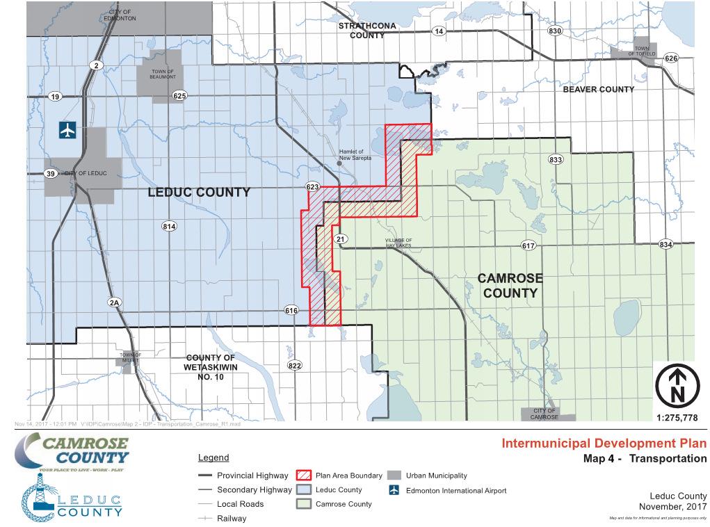
17 Map 4 Transportation 14
18 UTILITY CORRIDORS 1) The continued demand for the location or telecommunications infrastructure and utility servicing has the potential to impact land use within municipalities; however, the municipalities are aware that the jurisdiction of utility approvals is outside of their direct control. a) Where there is an application for a new, expanded or retrofitted telecommunications tower within the Plan Area, Both Counties shall notify the other County to seek their comments. b) When providing a Letter of Concurrence for a new, expanded or retrofitted telecommunications tower, Both Counties shall request telecommunications companies to co-locate within the Plan Area where technically feasible. c) When providing comments to provincial and federal departments regarding utility development within the Plan Area, Both Counties shall request that consideration be given to the establishment of utility corridors with multiple users. 2) Both Counties also acknowledge that the development of the oil and gas industry has played an integral part in the development of the region. Both Counties will work with the oil and gas industry to ensure that the orderly development of the Plan Area is not unduly restricted by the development of oil and gas infrastructure, including pipelines. PLAN ADMINISTRATION AND IMPLEMENTATION 1) Adoption Process a) This IDP and any amendments to it shall be adopted by bylaw by the Both Counties in accordance with the MGA. b) Any amendments to the Municipal Development Plans and Land Use Bylaws of Both Counties required to implement the policies of the Intermunicipal Development Plan should occur as soon as practicable following adoption of this IDP or any amendment to the IDP that establishes or amends policies within this IDP. 2) Approving Authorities a) In the hierarchy of statutory plans, the Intermunicipal Development Plan shall take precedence over the other municipal statutory plans. b) Each County shall be responsible for the administration and decisions on all statutory plans, land use bylaws, and amendments thereto within their boundaries. 3) Plan Amendments a) An amendment to this Plan may be proposed by either County. An amendment to the Plan proposed by a landowner shall be made to the County in which the subject land is located. 15
19 b) An amendment to this Plan has no effect unless adopted by Both Counties by bylaw in accordance with the MGA. 4) Intermunicipal Cooperation a) The Counties agree to create a recommending body known as the Intermunicipal Committee (hereinafter referred to as the Committee). b) The Committee will meet on an as required basis and will develop recommendations to the County Councils on all matters of strategic direction and cooperation affecting County residents, except matters where other current operating structures and mechanisms are operating successfully. The topics to be discussed will include: i) Long-term strategic growth plans for the Counties as may be reflected in the Intermunicipal Development Plan, Municipal Development Plans, Area Structure Plans and other strategic studies. ii) Intermunicipal and regional transportation issues including the Transportation and Utility Corridors, truck routes. iii) Prompt circulation of major land use, subdivision and discretionary development proposals in either municipality which may impact the other municipality; and iv) The discussion of intermunicipal or multi-jurisdictional issues in lieu of a regional planning system. c) The Committee shall consist of four members, being two Councillors from each County. d) The Chief Administrative Officers and/or designated staff will be advisory staff to the Committee, responsible to develop agendas and recommendations on all matters, and for forwarding all recommendations from the Committee to their respective Councils. 5) Plan Review a) Once every four years, commencing no later than 2022, the IDP will be formally reviewed by the Committee in conjunction with the Intermunicipal Collaboration Framework in order to confirm, or recommend amendment, of any particular policy contained herein. The Committee will prepare recommendations for consideration by the municipal councils. CIRCULATION AND REFERRAL PROCESS 1) Both Counties agree to refer the following planning proposals within the Plan Area: a) Municipal Development Plans and Municipal Development Plan amendments (28 day response period). b) Area Structure Plans, Area Redevelopment Plans and amendments (21 day response period). c) Land Use Redesignations (21 day response period). d) Subdivisions (21 day response period). e) Development permits for discretionary uses (21 day response period). f) Road access requests/notices (21 day response period). 16
20 DISPUTE/CONFLICT RESOLUTION 1) Both Counties agree that the following process shall be used to resolve or attempt to resolve disputes between the Counties arising from the following: a) Lack of agreement on proposed amendments to the IDP; b) Lack of agreement on any proposed statutory plan, land use bylaw or amendment to thereto for lands located within or affecting the Plan Area; or c) Lack of agreement on an interpretation of this IDP. 2) Lack of agreement pursuant to section Q(1)(a) or (b) is defined as a statutory plan, land use bylaw or amendment to either which is given first reading by a Council which the other Council deems to be inconsistent with the policies of this Plan or detrimental to their planning interests as a County. 3) A dispute shall be limited to the decisions on the matters listed in section Q(1). Any other appeal shall be made to the appropriate approving authority or appeal board that deals with that issue. 4) The dispute resolution process may only be initiated by either County Councils. 5) Identification of a dispute and the desire to go through the dispute resolution process may occur at any time regarding a dispute matter outlined in section Q(1)(c) and may only occur within 30 calendar days of a decision made pursuant to section Q(2). Once either County has received written notice of a dispute, the dispute resolution process must be started within 15 calendar days of the date the written notice was received, unless both Chief Administrative Officers agree otherwise. 6) In the event the dispute resolution process is initiated the County having authority over the matter shall not give any further approval in any way until the dispute has been resolved or the mediation process has been concluded. 7) In the event mediation does not resolve the dispute, the County may proceed to adopt the bylaw and in accordance with the Municipal Government Act, the other County will have the right to appeal to the Municipal Government Board. 8) The Intermunicipal Committee formed under the Intermunicipal Collaboration Framework will be the forum used to in relation to any disputes. Dispute/Conflict Resolution Process Stage 1 Administrative Review - The Chief Administrative Officers of Both Counties will meet in an attempt to resolve the issue first. Failing resolution, the dispute will then be referred to the Intermunicipal Committee. In the event a resolution is not achieved by the 30 th day following the first meeting of the Chief Administrative Officer of Both Counties, either County may refer the dispute to the Intermunicipal Committee. 17
21 Stage 2 Intermunicipal Committee Review The Committee will convene to consider and attempt to resolve the dispute. Failing resolution, the dispute will then be referred to mediation. In the event a resolution is not achieved by the 30 th day following the first meeting of the Intermunicipal Committee, either County may refer the dispute to the Mediation. Stage 3 Mediation The services of an independent mediator will be retained, with the mediator to present a written recommendation to both Councils. The costs of mediation shall be shared equally between the Counties. Stage 4 Municipal Government Board In the event the mediation process does not resolve the dispute, the County may proceed to adopt the bylaw and in accordance with the Municipal Government Act, the other County will have the right to appeal to the Municipal Government Board. CORRESPONDENCE 1) Written notice by mail under this Plan shall be addressed as follows: a. In the case of Camrose County to: Camrose County c/o Chief Administrative Officer Avenue Camrose, AB T4V 3S8 b. In the case of Leduc County to: Leduc County c/o Chief Administrative Officer th Street Nisku, AB T9E 2X3 2) In addition to Section R(1), notices may be sent by electronic mail to the Chief Administrative Officer. 18