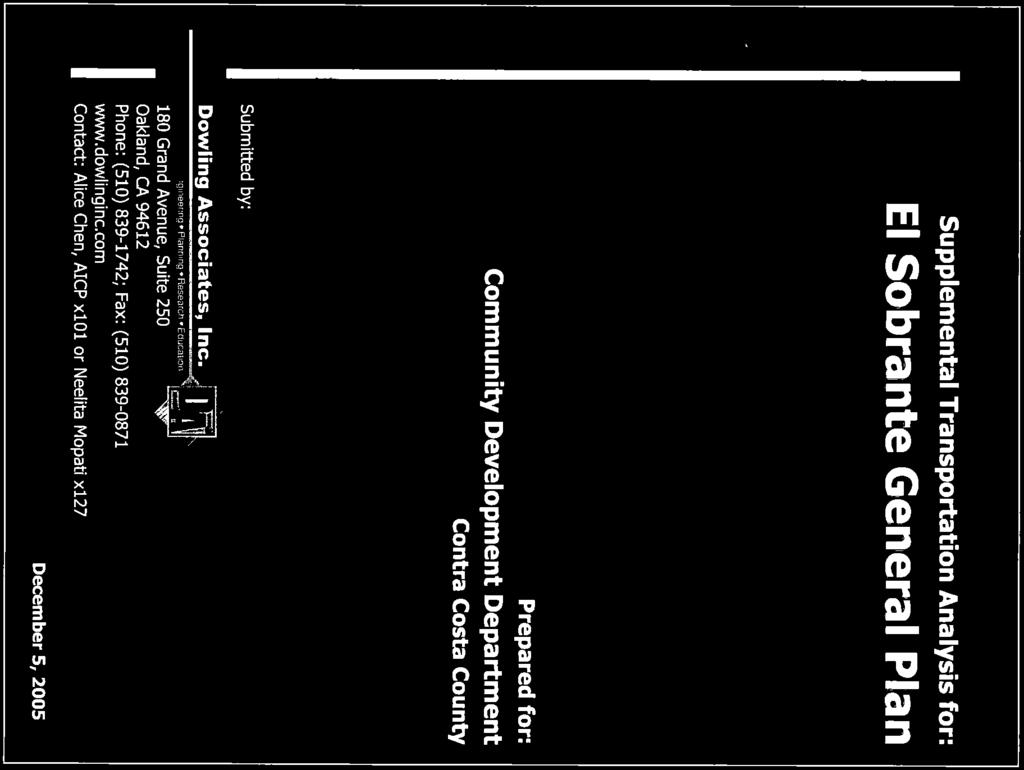
Downtown El Sobrante General Plan Amendment Final Environmental Impact Report County File: GP#
|
|
|
- Geoffrey James McKinney
- 5 years ago
- Views:
Transcription

1 Downtown El Sobrante General Plan Amendment Final Environmental Impact Report County File: GP# STATE CLEARINGHOUSE NO Prepared for Contra Costa County Department of Conservation and Development Community Development Division Prepared by Mills Associates Lafayette, California October 2010
2 DOWNTOWN EL SOBRANTE GENERAL PLAN AMENDMENT County File: GP# FINAL ENVIRONMENTAL IMPACT REPORT STATE CLEARINGHOUSE NO Prepared for Contra Costa County Department of Conservation and Development Prepared by Mills Associates Lafayette, California October 2010
3 TABLE OF CONTENTS I. Introduction... I-1 II. III. IV. List of Commenters... II-1 Comments and Responses... III-1 ERRATA...IV-1 Appendix A Traffic Data Downtown El Sobrante General Plan Amendment Final EIR Page i
4 I. INTRODUCTION A. Purpose of the Environmental Impact Report This document has been prepared in response to the comments received on the Draft Environmental Impact Report (EIR) for the proposed Downtown El Sobrante General Plan Amendment General Plan Amendment. The Draft EIR identified the likely consequences associated with the General Plan Amendment, and identified feasible mitigation measures to help reduce potential significant impacts. This Final EIR responds to comments on the Draft EIR, and it includes an ERRATA to revisions to the Draft EIR, as necessary, in response to these comments and corrects for omissions to the Draft EIR. None of these revisions result in significant changes to the Project Description or findings of the Draft EIR that would trigger need to recirculate the Draft EIR As described in the California Environmental Quality Act (CEQA) Guidelines, a number of types of EIRs exist. Different types of EIRS are used for varying situations and intended uses. As described in Section of the CEQA Guidelines, the most common type of EIR is a project EIR, which examines the environmental impacts of a specific development project. As described in Section of the CEQA Guidelines, a program-level EIR is appropriate when a project consists of a series of action related to the issuance of rules, regulations, and other planning criteria. In this case, the project that is the subject of this EIR is a General Plan Amendment that will be implemented over time as a series of land use and transportation/circulation policies to guide future development activities within the San Pablo Dam Road and Appian Way corridors in El Sobrante. No specific development projects are proposed as part of the General Plan Amendment. Therefore, this EIR is a program-level EIR, as described in the Draft EIR on page S-2. The program-level EIR under CEQA allows the County to consider and evaluate the General Plan Amendment s impacts by examining the environmental effects throughout the plan area, rather that on a case-by-case basis. The program-level EIR also allows for the examination of the effects of the General Plan Amendment s basic policy considerations, without requiring the County to re-consider such policy considerations each time a specific development project is proposed. As such in certifying this EIR, the County will have completed its duties under CEQA to consider the effects of adopting the General Plan Amendment as a policy framework for future development proposals. However, certification of this EIR would not exempt future development projects from CEQA review. Section (c) of the CEQA Guidelines outlines the additional environmental review requirements which must be conducted for a development project that occurs in area for which a program-level environmental review has been prepared. Under these requirements, if the County finds the potential environmental impacts of a proposed Downtown El Sobrante General Plan Amendment Final EIR Page I-1
5 development project located within the General Plan Amendment area were not evaluated in the program-level EIR, or not sufficiently mitigated by the program-level EIR, new environmental analysis would be needed for the proposed development project. B. Environmental Review Process CEQA Guidelines (Section 15132) require that upon completion of a Draft Environmental Impact Report (EIR) Contra Costa County Department of Conservation and Development, as lead agency, consult with and obtain comments from public agencies having legal jurisdiction with respect to a proposed project. In addition the County, as lead agency, must provide the general public with an opportunity to comment on the Draft EIR. The Draft EIR for the proposed Downtown El Sobrante General Plan Amendment was made available for public review on November 4, The Draft EIR was distributed to local and state responsible and trustee agencies, and the general public was advised of the availability of the Draft EIR through a public notice of completion and availability of the Draft EIR. The Draft EIR was circulated for a 45-day review from November 4, 2009 to December 18, In addition to notice of availability and circulation of the Draft EIR for public comment, the Contra Costa County Zoning Administrator conducted a public hearing on December 14, 2009 to receive comment on the Draft EIR. Copies of the Draft EIR were made available for public review online at the Contra Costa County website, listed under the What s New tab on the webpage for the Department of Conservation & Development, and in addition, hard copies were made available to the public at the Contra Costa County Library, El Sobrante and Central branches, Office of Supervisor John Gioia, District I, in El Cerrito and the Application & Permit Center, Contra Costa County Department of Conservation & Development, in Martinez, California. Response to comments have been prepared pursuant to County and State CEQA Guidelines (Section 15132), and respond to relevant and significant environmental issues received from public agencies and the general public on the Draft EIR. CEQA Guidelines specify that the Final EIR shall consist of the following: The Draft EIR or a revision of that draft; Comments and recommendations received on the Draft EIR; A list of persons, organizations, and public agencies commenting on the Draft EIR; The response of the Lead Agency to significant environmental points raised in the review and consultation process; and Any other information added by the Lead Agency. The written comments submitted on the Draft EIR did not raise any new issues to be addressed in the EIR, and did not result in substantial modifications to the analysis or conclusions contained in the Draft EIR. Aside from the ERRATA section, which makes corrections to text and figures, and includes the omission of a 2005 Supplemental Transportation Analysis cited in Final Transportation Analysis for Downtown El Sobrante General Plan Amendment, prepared by Dowling Associates (see ERRATA section, Appendix A, Traffic Data), the document remains as initially written and published. Downtown El Sobrante General Plan Amendment Final EIR Page I-2
6 This Final EIR will be provided to the County Planning Commission for its review prior to its consideration of resolution recommending the Board of Supervisors adoption of the General Plan Amendment. The County Planning Commission will be asked to make a recommendation to the Board of Supervisors on both the General Plan Amendment and the certification of the EIR. However, the County Planning Commission will not take final action on either the General Plan Amendment or the EIR. Instead, the Contra Costa County Board of Supervisors will consider the County Planning Commission s recommendation during a noticed public hearing and then take action on the proposed project, including certification of the EIR, the adoption of all necessary CEQA findings, and the adoption of program for mitigation and monitoring impacts identified in the EIR that are associated with the proposed project. Before the Board can approve the proposed project or a project alternative, the following findings must be made in order to certify the Final EIR for its adequacy: It has adequately disclosed the environmental effects of the proposed project, It has been completed in conformance with CEQA, It has been independently reviewed, and The information has been considered by the decision-making body. Given the presence of a significant and unavoidable impact resulting from the proposed project, the Board of Supervisors final action will need to contain a statement of overriding considerations pursuant to CEQA Guidelines Section C. Document Organization Following this introductory first chapter, Chapter II provides a list of persons and public agencies commenting on the Draft EIR. Chapter III includes copies of all written comments received on the Draft EIR and responses to significant environmental points raised in the written comments. The comments are arranged beginning with those received from agencies and individual letters follow in alphabetical order. Each comment letter and individual comments have been numbered. Where the response refers to a previous comment/response, it is shown as Response 3-2 for example. The number 3 represents the comment letter and the 2 represents the second comment of that letter. Chapter IV is the ERRATA, which includes any changes to the Draft EIR that have been identified in response to the comment letters, and it includes supplemental information for the transportation analysis that was inadvertently omitted when the Draft EIR was printed. Downtown El Sobrante General Plan Amendment Final EIR Page I-3
7 II. LIST OF COMMENTERS State Agencies 1 State of California, Governor s Office of Planning and Research, dated State of California, Department of Transportation (Caltrans), letter dated Regional Agencies 3 Contra Costa Local Agency Formation Commission, letter dated East Bay Municipal Utility District (EBMUD), letter dated West Contra Costa Transportation Advisory Committee, letter dated County Agency 6 Contra Costa County Flood Control & Water Conservation District, memorandum dated Cities 7 City of Pinole, letter dated City of Richmond, letter dated Individuals/Organizations 9 El Sobrante Municipal Advisory Council, letter dated El Sobrante Valley Planning & Zoning Advisory Committee, letter dated Marilynne Mellander, letter dated Kenoli Oleari, on behalf of the Institute of the Commons, the Long Range Education, Empowerment and Action Project, and the group of El Sobrante residents working to convert El Sobrante Elementary School into a community center, dated Downtown El Sobrante General Plan Amendment Final EIR Page II-1
8 III. COMMENTS AND RESPONSES
9 Letter [Letter 2] Downtown El Sobrante General Plan Amendment Final EIR Page III-1
10 LETTER 1 RESPONSE State of California Governor's Office of Planning and Research State Clearinghouse and Planning Unit Scott Morgan, Acting Director December 24, Comment acknowledged; no further response is necessary. Downtown El Sobrante General Plan Amendment Final EIR Page III-2
11 Letter Downtown El Sobrante General Plan Amendment Final EIR Page III-3
12 Downtown El Sobrante General Plan Amendment Final EIR Page III-4
13 Downtown El Sobrante General Plan Amendment Final EIR Page III-5
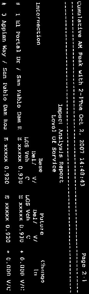
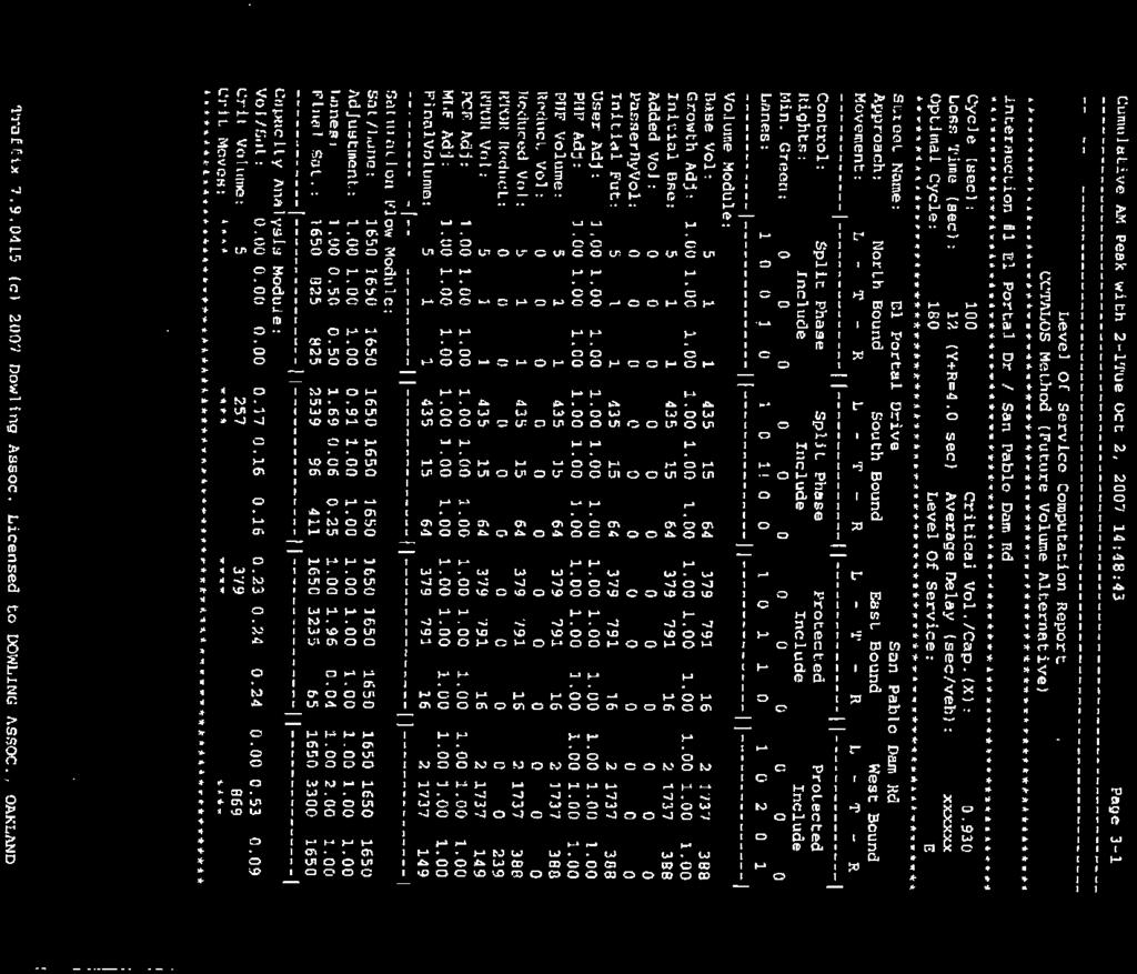
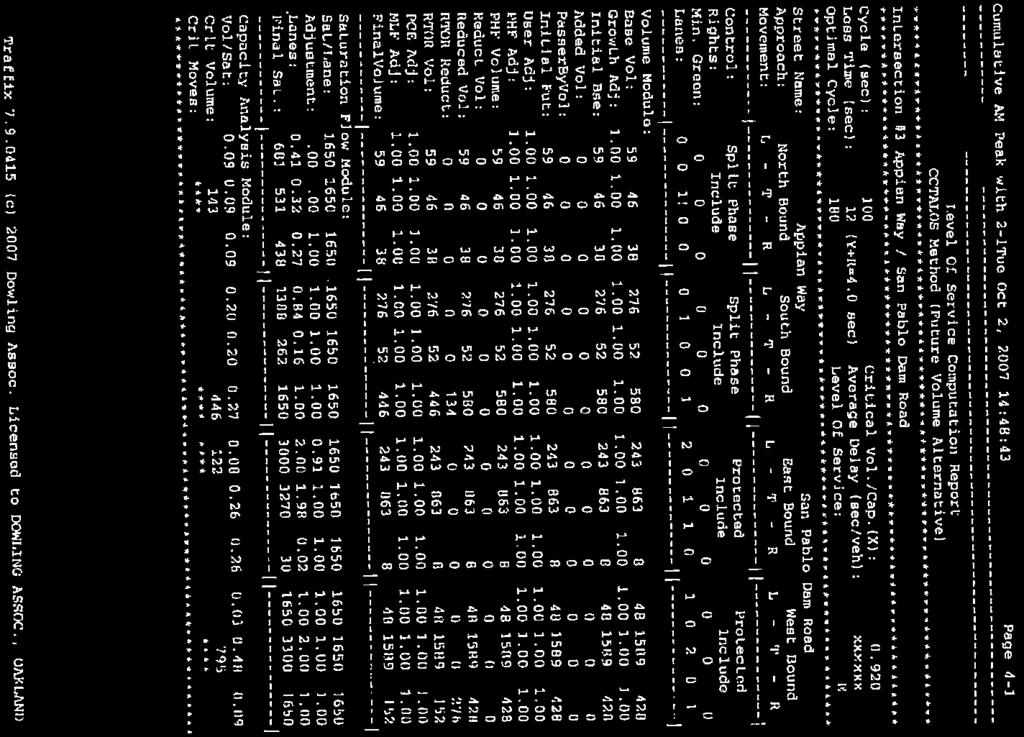
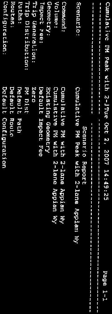
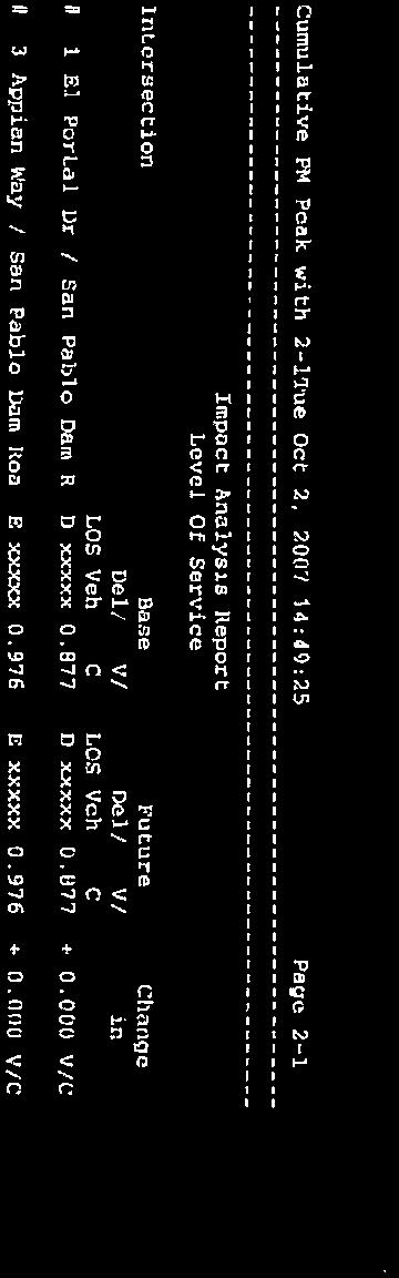
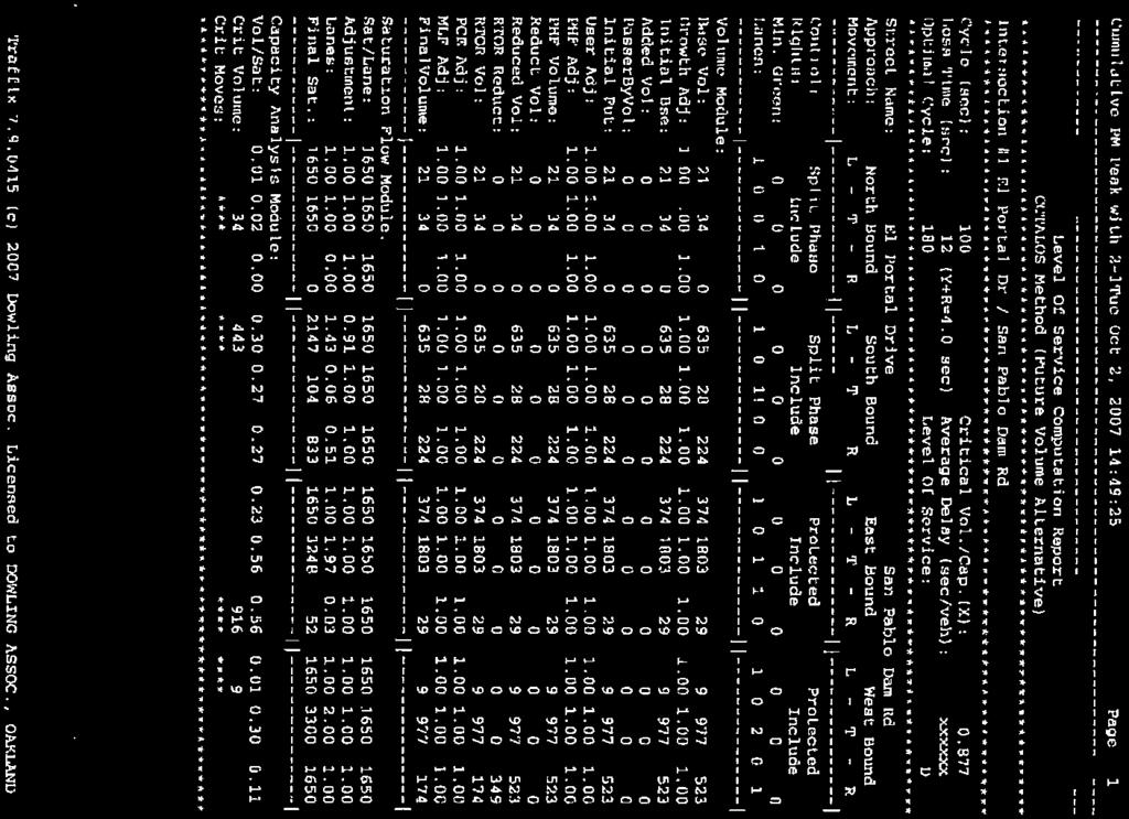
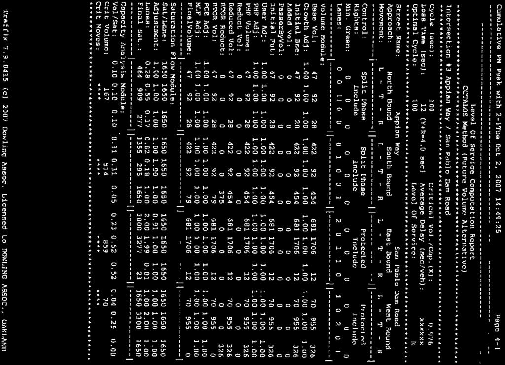
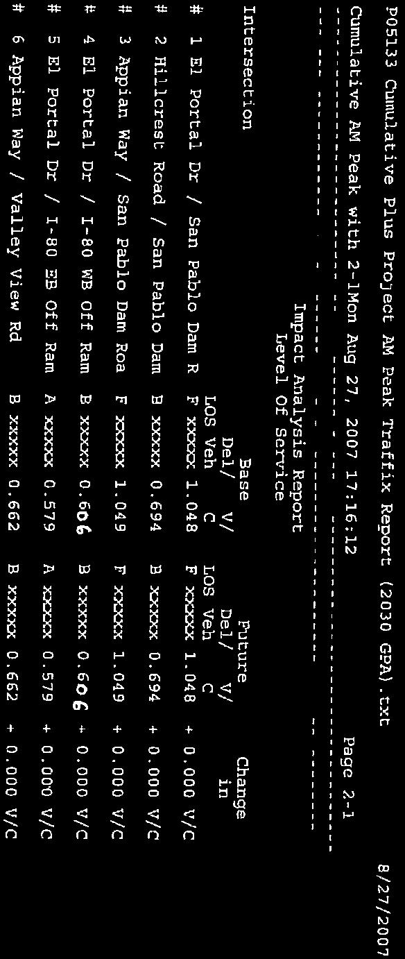
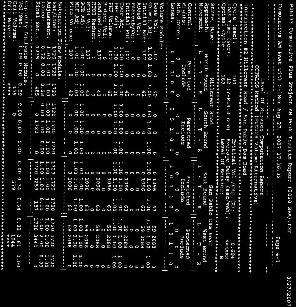
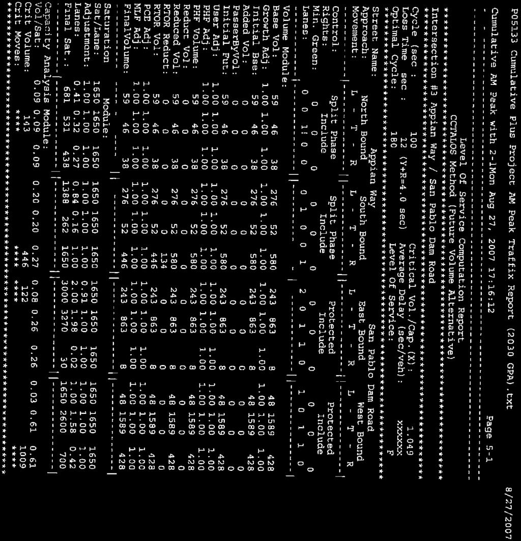
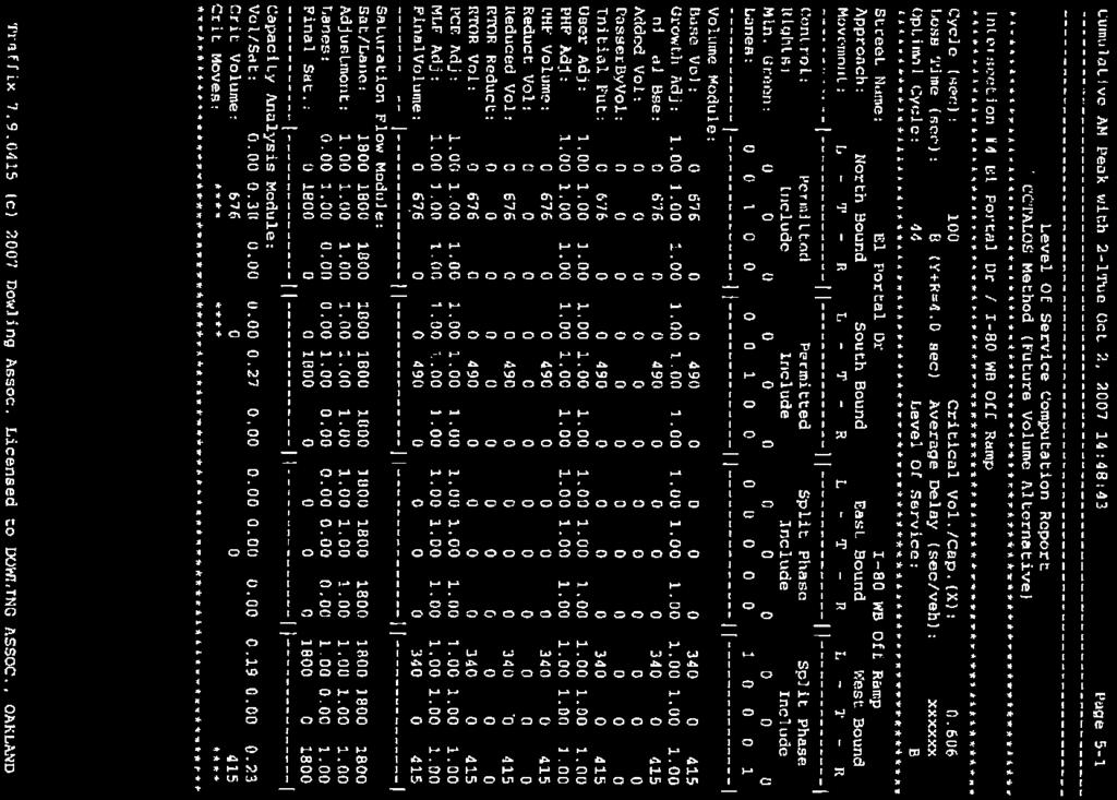
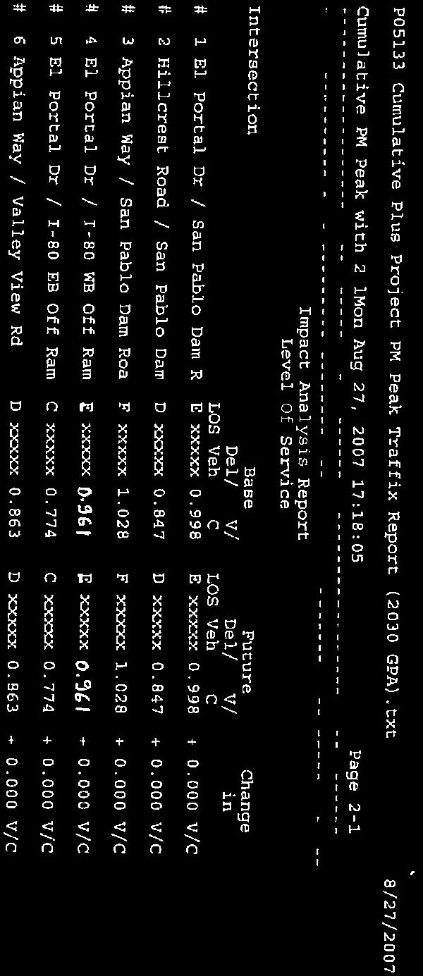
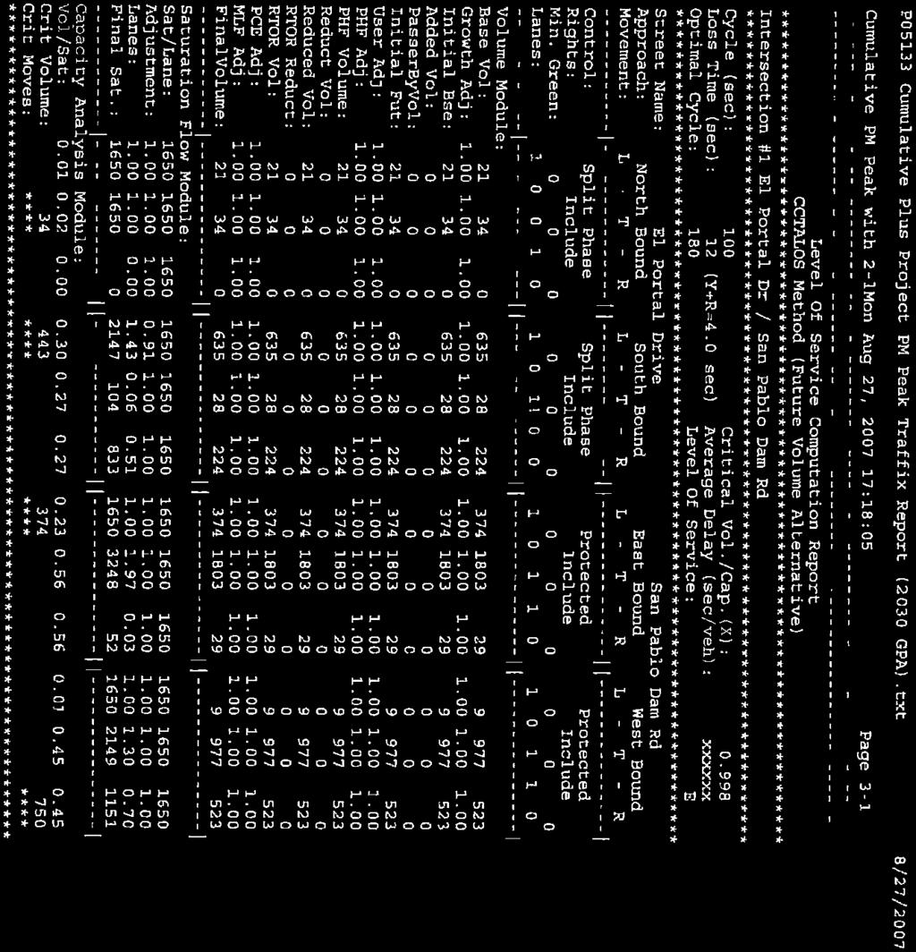
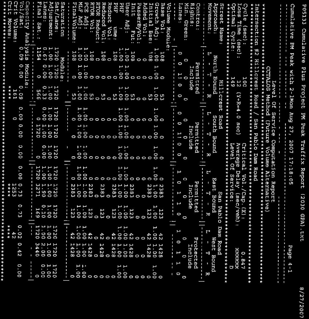
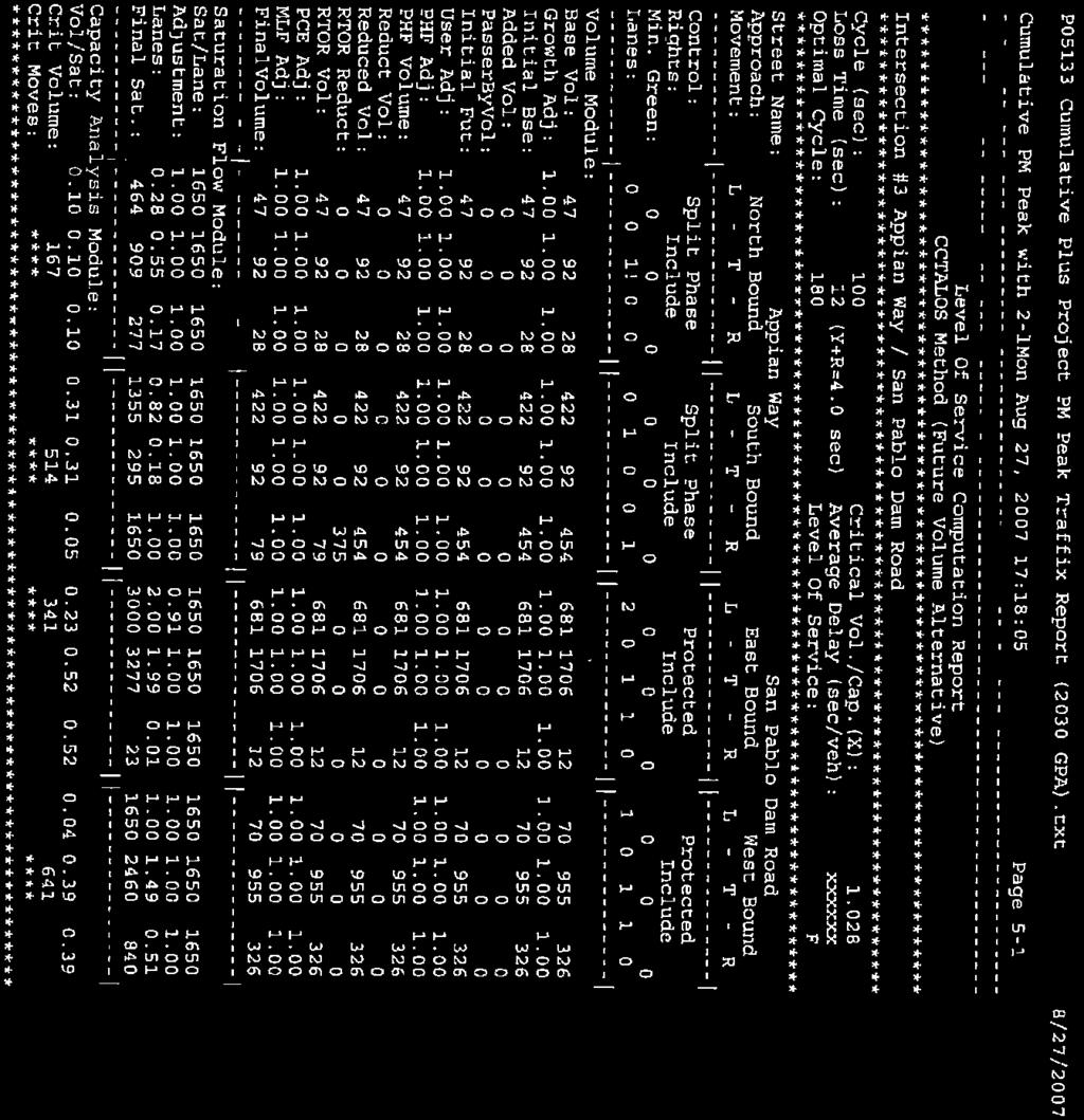
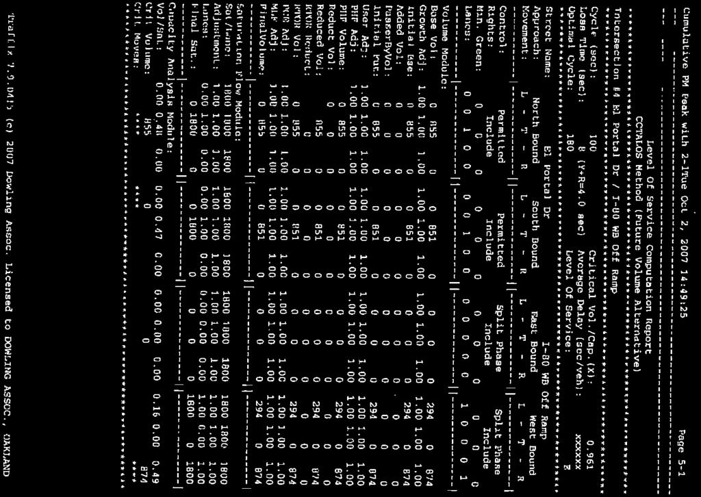
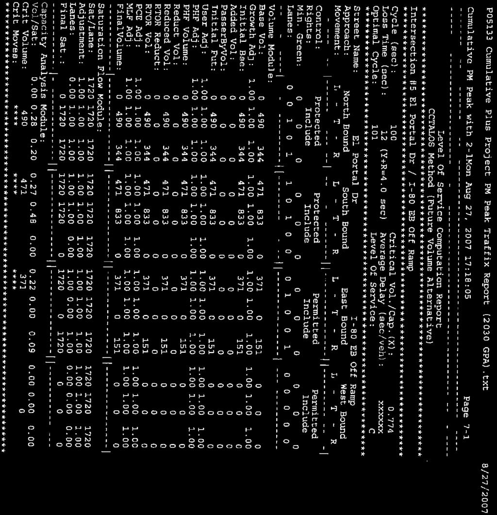
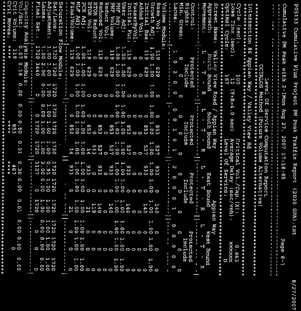
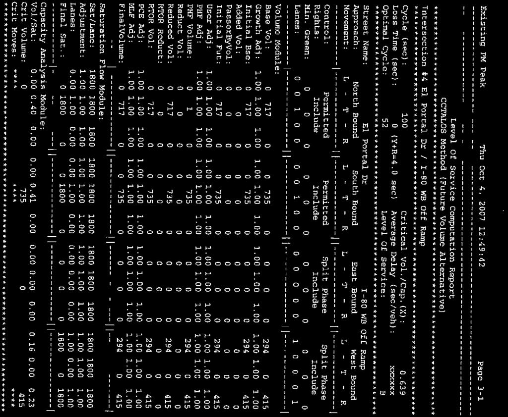
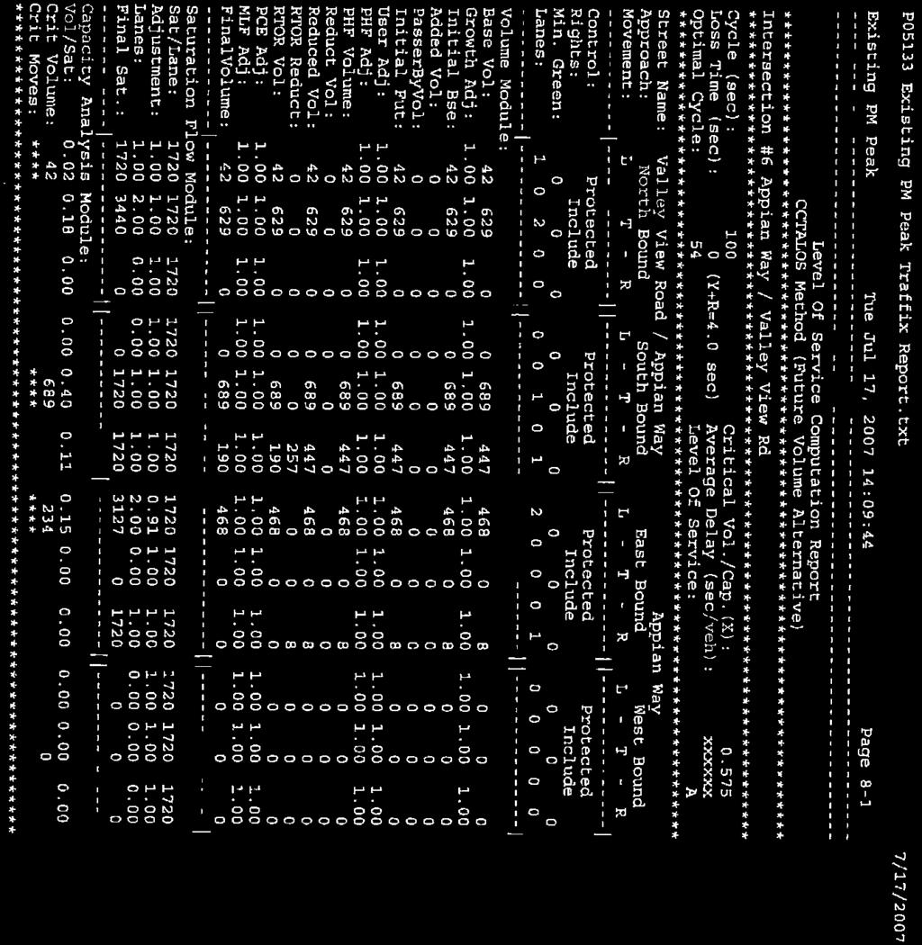
14 LETTER 2 RESPONSE State of California Department of Transportation (Caltrans) Lisa Carboni, District Branch Chief December 22, Comment noted. The southbound left-turn movement on Intersection 2 has been removed. 2-2 The intersection level of service worksheets from the Environmental Impact Report s transportation analysis (Dowling Associates, October 23, 2007) as referenced in Appendix B, Technical Traffic Data, were inadvertently omitted in printing. The intersection level of service worksheets are provided in the ERRATA, Section IV., see Appendix A, Traffic Data. 2-3 The level of service (LOS) at intersections using the Highway Capacity Method is unknown. The transportation analysis (Dowling Associates, October 23, 2007) uses the Contra Costa Transportation Authority (CCTA) LOS method. The CCTA LOS method is the standard procedure to evaluating congestion levels at signalized intersections for all jurisdictions in Contra Costa County. The use of this method for calculation LOS is required by under the Measure J Growth Management Program administered by the CCTA. Including another methodology would be costly and likely confusing to the public. It is further noted that the maximum intersection capacities under the Highway Capacity Method are typically lower than what is used in the CCTA method, and the CCTA method is generally a more conservative. 2-4 Comment noted. 2-5 The table is using CCTA LOS. Please also see above response to comment At this time, no turn restrictions are anticipated for the future San Pablo Dam Road/Pitt Way intersection. Since no engineering design for the new collector roadway connecting Pitt Way to Hillcrest Road has been prepared, it would not be possible to conduct a level of service evaluation for the future San Pablo Dam Road/Pitt Way intersection. Such level of service analysis will be conducted for the new intersection in conjunction with the design of the new collector roadway. 2-7 There was an error in the document and it has been corrected. The LOS for the El Portal Drive/I-80 WB Ramps should read 0.68/B under the Existing + Project condition. This classification is based on the LOS Ranges stated in Table 9 (page 52) of the CCTA Technical Procedures (2006 Update). See ERRATA for the correction. 2-8 The report does state that the proposed General Plan Amendment would leave the lane configuration for San Pablo Dam Road and Appian Way unchanged. Table compares volume and volume-to-capacity ratio for San Pablo Dam Road, Appian Way and El Portal Drive in the Future + Project and No Project scenarios. This table is provided to show the difference in v/c ratio and volume with and without the GPA. Downtown El Sobrante General Plan Amendment Final EIR Page III-6
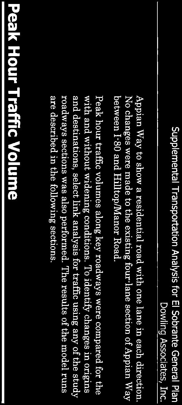
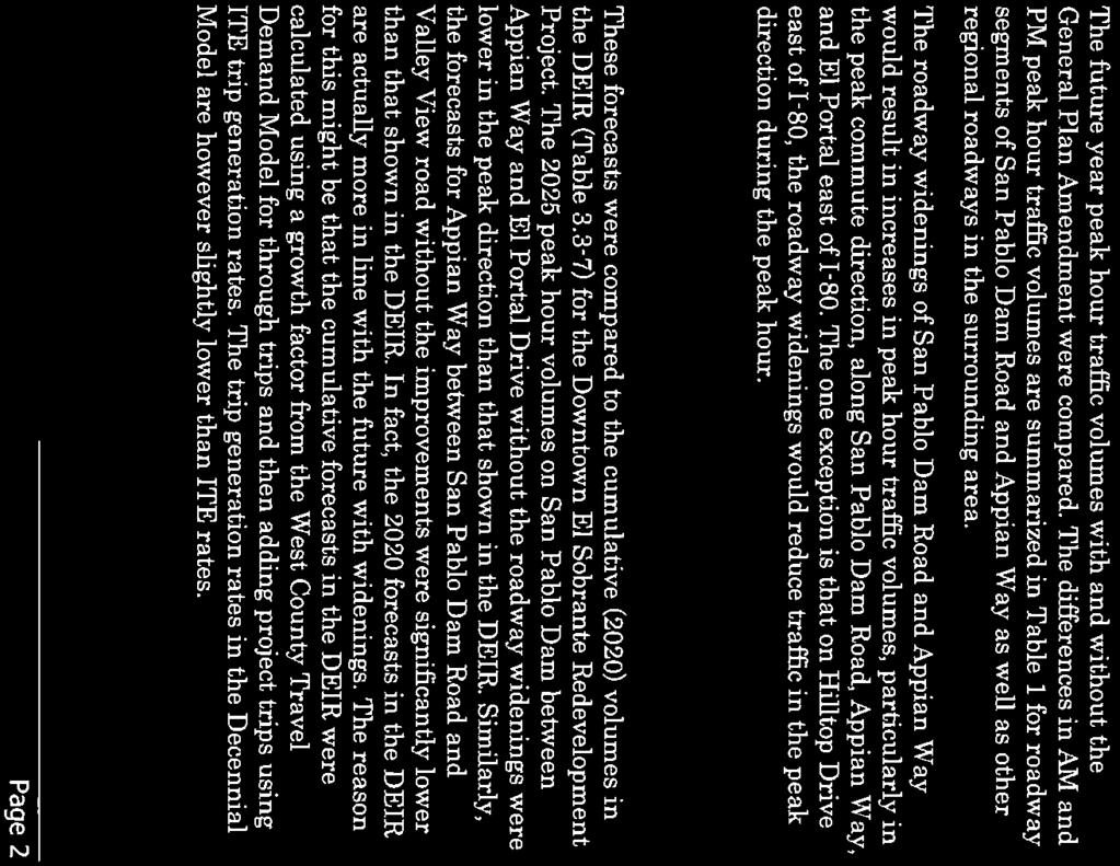
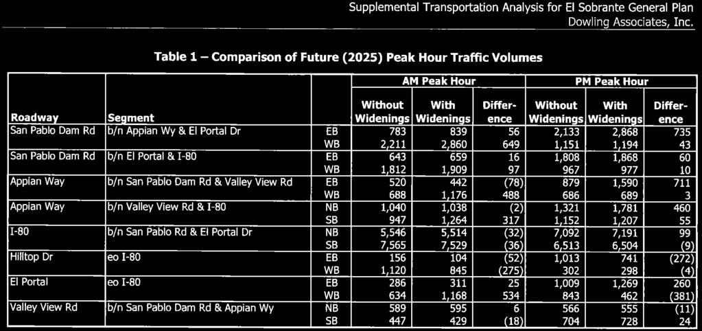
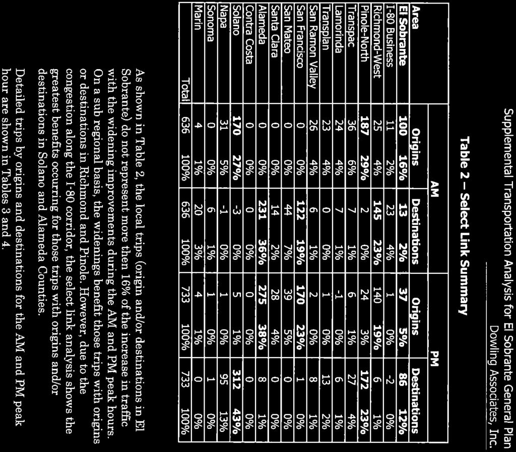
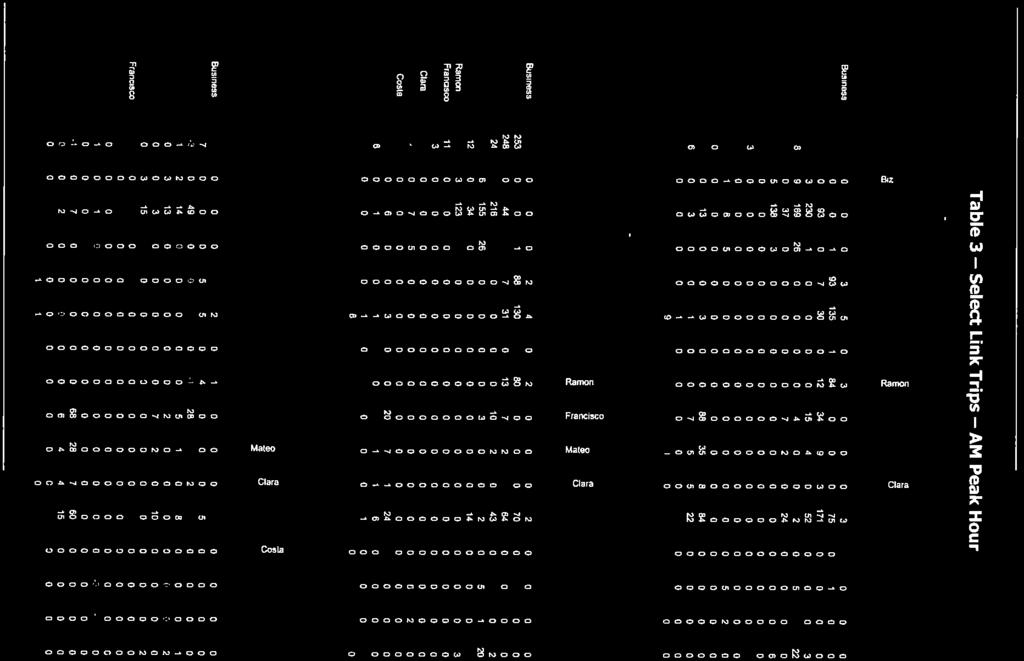
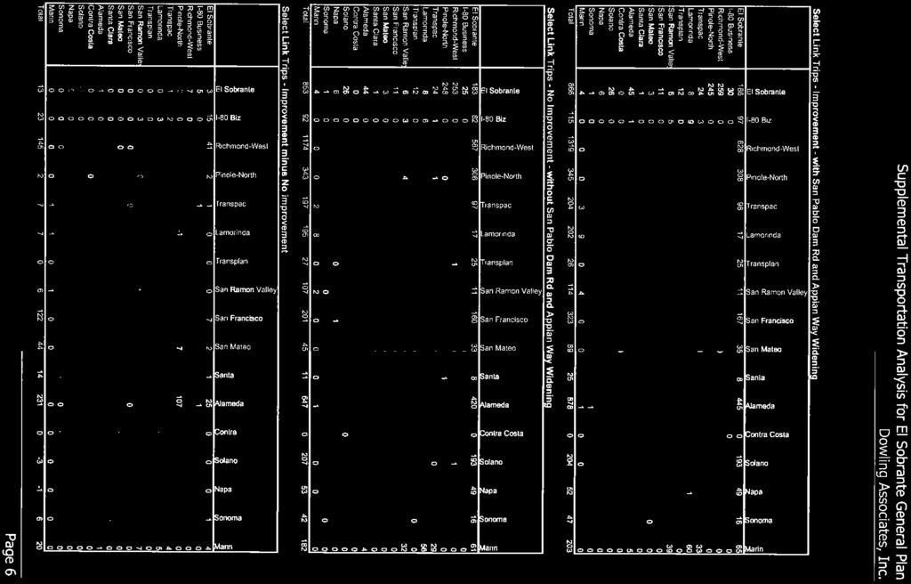
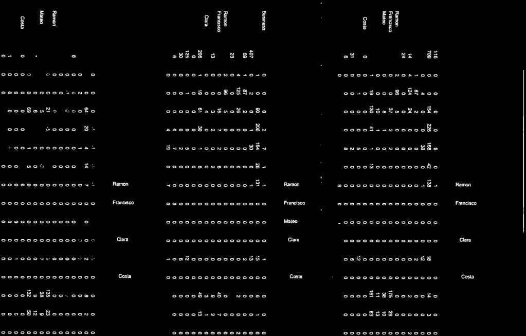
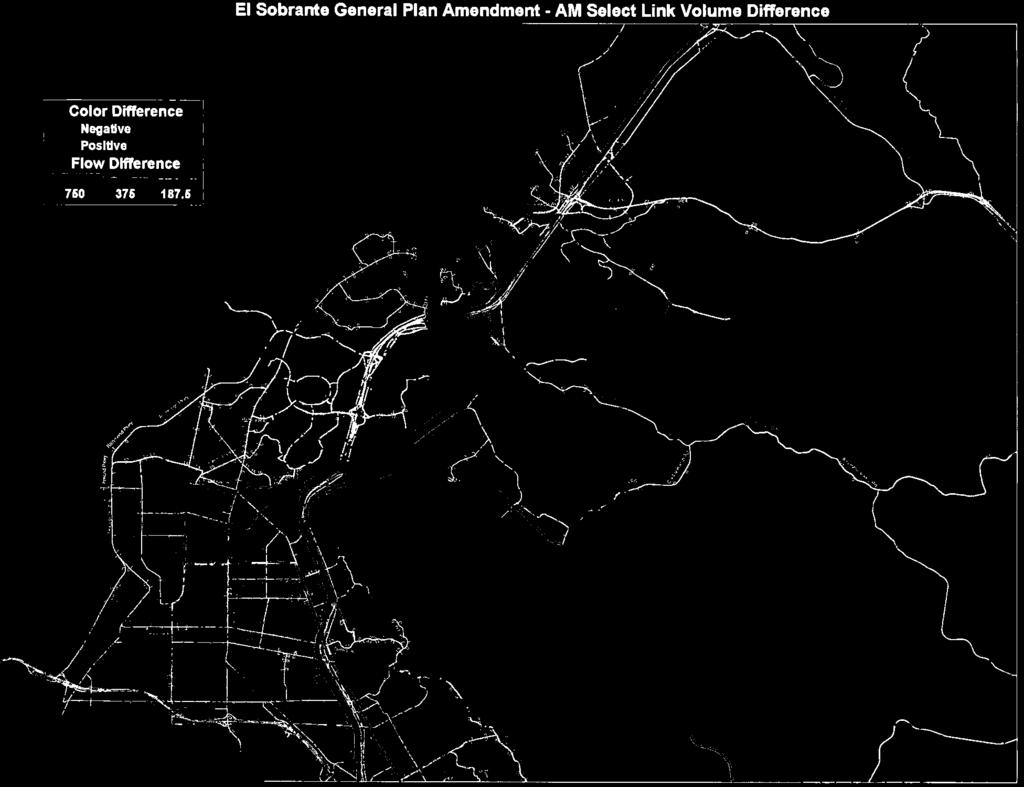
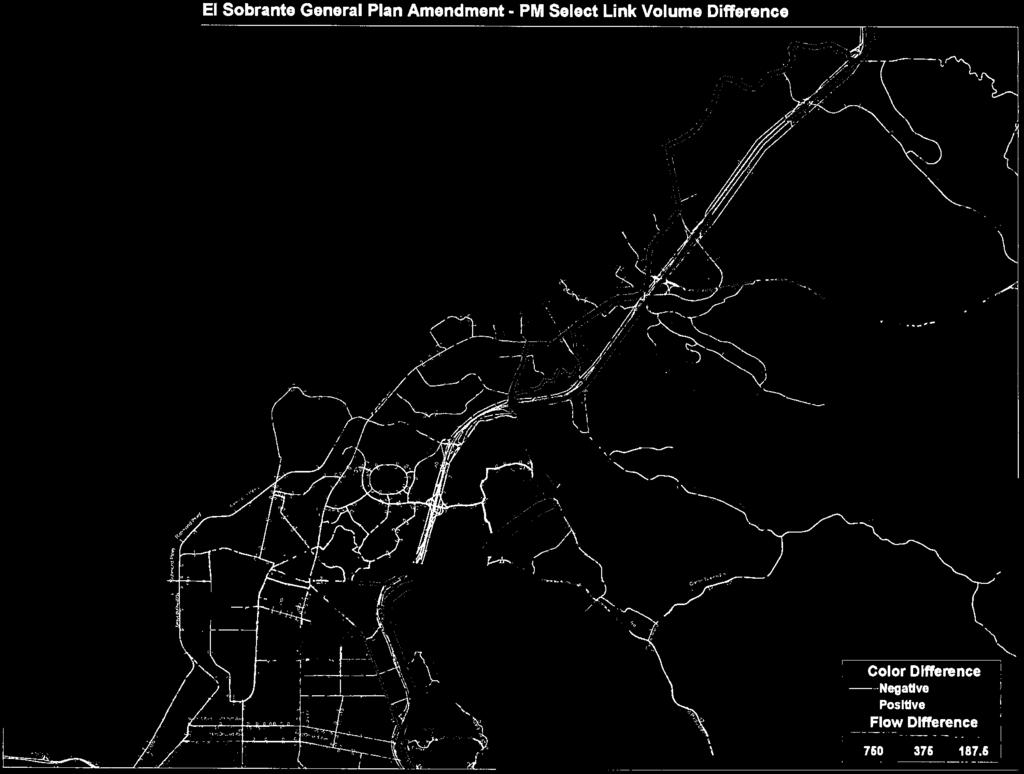
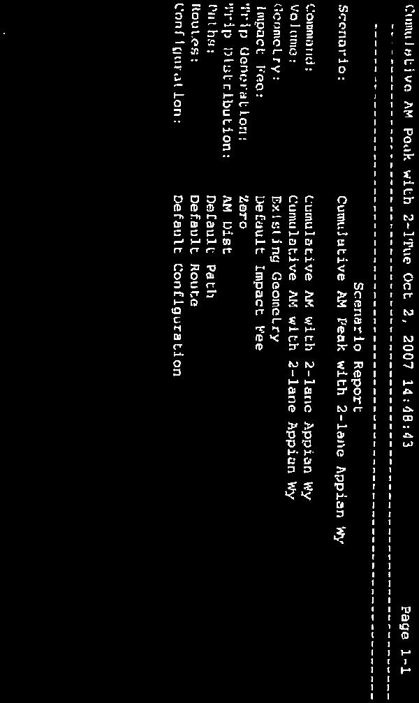
15 A select link analysis for the Downtown El Sobrante General Plan Amendment, prepared for the 2005 Supplemental Transportation Analysis by Dowling Associates (see Section IV, ERRATA, for a copy of the referenced document), indicated that traffic delays on the freeway would significantly increase during the next 20 years such that traffic from I-80 would be prone to utilize additional lanes on San Pablo Dam Road to avoid freeway congestion. El Portal Drive is not impacted by this diversion as much as San Pablo Dam Road as shown in the 2005 Supplemental Transportation Analysis 1. In the project horizon year, this situation would worsen due to increasing traffic volumes diverted from I-80 to San Pablo Dam Road if its capacity were increased. Figure and Table represent two different project scenarios; Existing + Project, and Future/No project and Future + Project, respectively. 2-9 The proposed project could result in the development of 490 dwelling units (Page 2-8). There are a total of 4,676 households in El Sobrante (Page 3-5). The proposed project would result in an approximately 11percent increase in the total number of households. There are approximately 125 spaces at the park & ride lot in question (intersection of EB I-80 and Hilltop Drive), and on an average weekday only about one-third of its capacity is used 2. Based on this information, it would be reasonable to assume that the park & ride lot should have the available capacity to meet the demands of future residents in the El Sobrante area. In addition, there are various other ridesharing facilities available along and in close proximity to the I-80 corridor that are near the project area that could potentially accommodate future demand. For example, the Richmond Parkway Transit Center which is proposed for expansion, the Hercules Transit Center, as well as park and ride facilities off of the I-80/Willow Avenue intersection in Rodeo Comment noted. 1 The 2005 Supplemental Transportation Analysis for the Downtown El Sobrante General Plan Amendment was conducted to supplement the traffic information for Contra Costa County s Downtown El Sobrante General Plan Amendment. Page 31 of the Final Transportation Analysis for the Downtown El Sobrante General Plan Amendment (see under Appendix B, Technical Traffic Data, Draft Environmental Impact Report) provides a discussion on traffic diversion. 2 Per verbal communication with 511 Contra Costa. 511 Contra Costa is a comprehensive transportation demand management program, which promotes alternatives to the single occupant vehicle. 511 Contra Costa is sponsored by all twenty jurisdictions in Contra Costa County through four regional transportation planning committees SWAT (southwest county), TRANSPAC (central county), TRANSPLAN (east county), and WCCTAC (west county). Downtown El Sobrante General Plan Amendment Final EIR Page III-7
16 Letter 3 Downtown El Sobrante General Plan Amendment Final EIR Page III-8
17 Downtown El Sobrante General Plan Amendment Final EIR Page III-9
18 LETTER 3 RESPONSE Contra Costa Local Agency Formation Commission (LAFCO) Lou Ann Texeira, Executive Officer December 15, A review of maps of the service area boundaries contained in the Directory of Local Agencies, prepared by Contra Costa Local Agency Formation Commission (October 2009), confirms that the project area (proposed Downtown El Sobrante General Plan Amendment) is within service areas for fire protection (Contra Costa Fire Protection District), sewer service (West County Wasterwater District) and water service (East Bay Municipal Utility District). 3-2 A review of the service area boundary map for County Service Area L-100, street lighting, prepared by Special District Section, Contra Costa County Public Works Department, confirms that project area (proposed Downtown El Sobrante General Plan Amendment) is within existing service area for the County Service Area L-100 covering El Sobrante. 3-3 The reference to East Bay Regional Park District (EBRPD) has been included in the ERRATA. 3-4 The LAFCO comment regarding the City of Richmond Sphere of Influence is noted. Downtown El Sobrante General Plan Amendment Final EIR Page III-10

19 Downtown El Sobrante General Plan Amendment Final EIR Page III-11
20 Letter Downtown El Sobrante General Plan Amendment Final EIR Page III-12
21 Downtown El Sobrante General Plan Amendment Final EIR Page III-13
22 LETTER 4 RESPONSE East Bay Municipal Utility District (EBMUD) William Kirkpatrick Manager of Water Distribution Planning December 14, The correction regarding the completion of the Freeport Regional Water Project has been included in the ERRATA. 4-2 Information pertaining to future development and location of water main extensions, water supply, fire flows, etc. is hereby noted. As individual project applications are submitted to the County Department of Conservation and Development, specific water supply information will be solicited from EBMUD at that time. 4-3 EBMUD s water recycling policy 8.01 is acknowledged. As a part of the planning process, the County solicits input from the water agency when individual project applications are submitted. Downtown El Sobrante General Plan Amendment Final EIR Page III-14
23 Letter Downtown El Sobrante General Plan Amendment Final EIR Page III-15
24 LETTER 5 RESPONSE West Contra Costa Transportation Advisory Committee Christina Atienza, Executive Director December 18, Comments acknowledged; no further response required. Downtown El Sobrante General Plan Amendment Final EIR Page III-16

25 Letter Downtown El Sobrante General Plan Amendment Final EIR Page III-17

26 Downtown El Sobrante General Plan Amendment Final EIR Page III-18
27 Downtown El Sobrante General Plan Amendment Final EIR Page III-19
28 LETTER 6 RESPONSE Contra Costa County Flood Control & Water Conservation District Homira Shafaq, Staff Engineer Flood Control December 17, The comment recommends that an assessment of the drainage impacts to San Pablo Creek, downstream of the project boundary, be provided to demonstrate that the increased storm runoff for the 100-year storm at Appian Creek, San Pablo Creek, and other natural watercourses, due to implementation of the General Plan Amendment would not adversely affect neighborhoods outside the project boundary. The General Plan Amendment does not specifically propose the building of new structures or the expansion of existing ones, therefore it is not possible to quantify the storm runoff that could be generated by future construction nor discuss the distribution of associated stormwater runoff in the EIR. The proposed project is a General Plan Amendment, which this EIR addresses. It includes establishment of new mixed use land use designations and corresponding policy changes to the Land Use and Transportation/Circulation elements to the County General Plan affecting the San Pablo Dam Road and Appian Way corridors. There are no individual development projects under consideration at this time. Section 3.10 of the Draft EIR discusses relevant State and local stormwater regulations. When an individual project application within the project area is submitted, the applicant will be responsible for submitting a drainage study at that time. 6-2 There is no specific development project under evaluation at this time that requires verification of the floodplain map. The map presented within the EIR provides an overview of the potential for flooding within the study area. 6-3 As individual development projects are submitted, applicants will be informed of the drainage fees and will be responsible for those fees as a condition of approval. 6-4 Comment noted. The funding of Drainage Area 73 has been a standard condition of approval used by the County for development projects within the affected areas of El Sobrante. 6-5 Comment noted. Future development projects will be responsible for mitigating the impact of additional stormwater runoff as a condition of project approval. 6-6 Comment noted. Future development projects will be responsible for the design and construction of storm drain facilities as a condition of project approval. 6-7 Comment noted. Individual project applicants will be informed of the 100-year flood boundary and the Flood Plain Management ordinance at the start of the planning process. Downtown El Sobrante General Plan Amendment Final EIR Page III-20
29 6-8 It is acknowledged that certain regulatory permits may be required when the stream courses or drainage systems are impacted by future development projects. The applicability of regulatory permits will be determined when specific project applications are submitted. Downtown El Sobrante General Plan Amendment Final EIR Page III-21
30 Letter Downtown El Sobrante General Plan Amendment Final EIR Page III-22

31 Downtown El Sobrante General Plan Amendment Final EIR Page III-23
32 LETTER 7 RESPONSE City of Pinole Belinda Espinosa, City Manager December 18, The Traffic Service Objective (TSO) for Appian Way (from San Pablo Avenue to San Pablo Dam Road) is LOS D in the West Contra Costa Transportation Advisory Committee (WCCTAC) Action Plan. According to the CCTA Traffic Service Objective Monitoring Report (2007), the intersection of Appian Way and Fitzgerald Drive/Sarah Drive operates at Level of Service (LOS) B in the AM peak hour period, and LOS C in the PM peak. Based on the 2005 Supplemental Transportation Analysis (see ERRATA, Appendix A), the traffic volumes for Appian Way between Valley View Road and I-80 are expected to increase in the cumulative scenario (2025). However, with the widening of Appian Way, under the cumulative scenario there will be approximately 862 additional vehicle trips on the southbound approach (peak direction) of the Appian Way road segment in the AM, and 611 vehicle trips in the opposite direction during the PM peak period versus if the widening is not applied (see Table ). In other words, if Appian Way is widened pursuant to existing General Plan policy, there would be a substantial amount of new traffic traversing through the City of Pinole on Appian Way which would not occur with the change in policy under the General Plan Amendment. 7-2 Side street delays were not analyzed off of Appian Way. Measuring side street delays is not a traffic service objective (TSO) for San Pablo Dam Road in the WCCTAC Action Plan 2000 Update. 7-3 Mitigation would require future developments in the project area to analyze their impacts on transit service. The location and frequency of bus stops along the corridors within the project area would ultimately be determined by the transit service provider. Addressing specific transit improvements and amenities could not be effectively identified at this time because individual development projects create unique situations and needs. The adequacy of bus stops and their locations, access, and sidewalks is not evaluated under this program-level EIR. However, the County has made the following changes to the aforementioned mitigation measure to ensure that all development within the project area will be considered (see changes to text that is italicized, underlined, and highlighted in yellow).. MITIGATION MEASURE 3.3-5: The County shall consult with AC Transit prior to the approval of all individual projects along the project area portions of San Pablo Dam Road and Appian Way, within unincorporated County area, that may significantly increase transit patronage. Increases in transit demand generated by individual projects shall be assessed at the time application is made. The County shall forward an agency referral to AC Transit requesting comments on proposed developments that result in a net increase in vehicle trips. Individual projects shall provide mitigation to accommodate increases in transit demand, if necessary. Downtown El Sobrante General Plan Amendment Final EIR Page III-24
33 Letter Downtown El Sobrante General Plan Amendment Final EIR Page III-25
34 LETTER 8 RESPONSE City of Richmond Kieron Slaughter, Assistant Planner Planning Department December 7, It is not possible to assess cumulative impacts associated with the City s draft General Plan, without the ability to review the Draft Environmental Impact Report (EIR) for the General Plan update, because to date it has not been released for public review and comment. 8-2 This comment is requesting that the County s EIR match the thresholds and development standards for the proposed mixed use designations with those proposed under the Draft City of Richmond General Plan. It is not possible to respond to this request because the Draft EIR for the Richmond General Plan update has not been released from which such a comparison could be attempted. 8-3 As requested, a copy of the City s Draft General Plan Land Use Map is attached. 8-4 The City of Richmond Pedestrian and Bicycle Improvement Plan under the Draft City General Plan (December 2009) reflects a planned Class II and Class III bicycle route along San Pablo Dam Road and Appian Way. San Pablo Dam Road is identified as a planned Class III bicycle route under the Bicycle Facilities Network Map, Contra Costa County General Plan ( ). The proposed General Plan Amendment would re-classify San Pablo Dam Road as a Class II and Class III bicycle route. Downtown El Sobrante General Plan Amendment Final EIR

35 Downtown El Sobrante General Plan Amendment Final EIR Page III-27
36 Letter Downtown El Sobrante General Plan Amendment Final EIR Page III-28
37 Downtown El Sobrante General Plan Amendment Final EIR Page III-29
38 Downtown El Sobrante General Plan Amendment Final EIR Page III-30
39 Downtown El Sobrante General Plan Amendment Final EIR Page III-31
40 Downtown El Sobrante General Plan Amendment Final EIR Page III-32
41 Downtown El Sobrante General Plan Amendment Final EIR Page III-33
42 Downtown El Sobrante General Plan Amendment Final EIR Page III-34
43 LETTER 9 RESPONSE El Sobrante Municipal Advisory Council Barbara Pendergrass, Chair December 7, The comment refers to the planning process and not to the adequacy of the EIR; therefore no further response is necessary. 9-2 The proposed policy describing the rezoning to the Planned Unit District (P-1) District for Appian Way was inadvertently omitted in the Draft EIR. The proposed policies for the Appian Way corridor under the General Plan Amendment direct that this area be zoned to the P-1 District. 9-3 The correct spelling of Barbara Pendergrass is included in the ERRATA. 9-4 The change regarding auto, pedestrian and bicycles is included in the ERRATA 9-5 The ERRATA reflects the elimination of the following sentence that appears on page S-3, third paragraph: No significant areas of controversy are known or have been brought to the attention of County of Contra Costa with regard to the proposed General Plan. 9-6 Neighborhood streets in the vicinity of the project area (e.g. Hilltop Drive, La Paloma Road, and Manor Road) could be affected by diversion traffic as a result of the proposed General Plan Amendment. Diversion would occur when main arterial roads such as San Pablo Dam Road and Appian Way become congested and experiencing higher traffic volumes. Mitigation Measure 3.3-3, page 3-52 of the Draft EIR, addresses this issue with the establishment of a Neighborhood Traffic Calming Program. The Neighborhood Traffic Calming Program provides a tool kit and process for identifying, measuring, and dealing with problems related to traffic safety on local streets. This process also facilitates the County s goal to provide for safe and efficient vehicular, pedestrian, and bicycle movements on Contra Costa County streets. Traffic calming strategies designed to address diversion traffic would be better analyzed for their feasibility and effectiveness once project specific impacts are determined. Such strategies may include, but are not be limited to; installing center medians, chockers/bulbouts at intersections, parabolic and/or flat topped speed humps, speed cushions, traffic circle or roundabouts, etc. 9-7 The General Plan Amendment proposes new land use designations and supporting policy changes to the Land Use and Transportation/Circulation elements to the County General Plan affecting the San Pablo Dam Road and Appian Way corridors. A precise alignment study for San Pablo Dam Road would be initiated once the General Plan Amendment has been adopted. The precise alignment study would examine the ability to provide travel lanes and space for bicycle lanes, curb parking, expanded or improved sidewalk area, and bus transit stops within the existing road right-of-way, and reviewing the operational aspects within the existing right of way. The County concurs Downtown El Sobrante General Plan Amendment Final EIR Page III-35
44 that a parking management plan should be developed which could better manage existing conditions. Although there are presently limited resources available to conduct either a precise alignment study or a parking management plan, the County will pursue such studies and secure necessary funding to initiate and complete them. 9-8 As new projects are processed through the County planning process, they will be reviewed for compliance with Tittle 24 of the California Building Code to ensure that they have incorporated the latest energy efficient measures. 9-9 Page 2-2 of the Draft EIR refers to the new collector street, not San Pablo Dam Road; thus there is no contradiction between the statements on page 2-2 and page The statements on Page 2-2 and 3-32 are consistent. The proposed General Plan Amendment would retain San Pablo Dam Road as a four-lane facility (two lanes in each direction), and promote the various streetscape improvements listed. The DEIR starting at page 3-9 and ending at 3-18 is simply restating the existing policies that are contained in the General Plan The Draft EIR is citing the existing policies contained in the County General Plan The Draft EIR is citing the existing policies contained in the County General Plan The County acknowledges that the El Sobrante area lacks sufficient park acreage. However, the Draft EIR addresses new mixed use designations and policy changes to the County General Plan within a specific project area, the San Pablo Dam Road Commercial Core and the Appian Way corridors, taken together comprising Downtown El Sobrante, and not the entire El Sobrante planning area Comment noted. The ERRATA reflects the statement that the community rejected annexation to the City of Richmond The Draft EIR evaluated the roads in El Sobrante identified in the Roadway Network Map, Transportation/Circulation Element, Contra Costa County General Plan ( ). These roads included in the road network were assumed in the traffic modeling used for the Draft EIR The traffic hours studied in the Draft EIR reflect the peak of the peak hour commute period On page 3-32, Project Conditions, the statement in the Draft EIR refers to existing policies in the General Plan, not the proposed project that amends these policies Figure and have been revised to show the additional collector facilities that were not described in the Draft EIR. The project proposes a General Plan Amendment that will establish policies intended to promote a development pattern that is more compact and conducive to downtown businesses and residential environment. The Appian Way and San Pablo Dam Road corridors would be affected by these changes and were studied and analyzed in the Draft EIR. Downtown El Sobrante General Plan Amendment Final EIR Page III-36
45 9-19 The County acknowledges that a parking management plan is needed. However, the Draft EIR evaluates the impacts resulting from the proposed General Plan Amendment, which is the establishment of new mixed use designations and corresponding policy changes for San Pablo Dam Road and Appian Way within the Land Use and Transportation/Circulation elements to the County General Plan 9-20 Comment noted. The table has been corrected to refer to year 2003; refer to ERRATA sheet Comment noted. The intersections listed in Figure and Table are the study intersections. As explained above, the Draft EIR evaluated the roads in El Sobrante reflected in the Roadway Network Map, Transportation/Circulation Element, Contra Costa County General Plan ( ). These roads in the Road Network Map, which directly serve the project area, were included in the traffic modeling and analysis used for the Draft EIR 9-22 Comment noted. Mitigation Measure 3.3-3, page 3-52 of the Draft EIR, addresses this issue by the establishment of a Neighborhood Traffic Calming Program. This program provides a tool kit and process for identifying, measuring, and dealing with problems related to traffic safety on local streets and diversion of traffic onto residential streets. The Institute of Traffic Engineers defines traffic calming as the combination of mainly physical measures that reduce the negative effects of motor vehicle use, alter driver behavior, and improve conditions for the non-motorized street users. Traffic calming seeks to improve neighborhood livability and pedestrian safety through the reduction of average travel speeds on residential streets from a range of measures. These measures can be used to address problems from speeding, cut-through traffic, increase volume, and pedestrian/bicyclist safety. One key objective is the reduction in travel speeds to discourage use of residential streets for cut through traffic or commute traffic. Traffic calming relies on the installation of physical features to slow vehicle speed and enhance safety on residential streets. This is accomplished by incorporating design elements into the roadway, such as crosswalks, chockers/bulbouts at intersections, parabolic and/or flat topped speed humps, speed cushions, traffic roundabouts and traffic circles. Such elements either lead a driver to travel at a reduced speed or to seek a more direct route of travel. As the term implies, the Neighborhood Traffic Calming Program involves the direct participation of residents within the affected neighborhood. Neighborhood residents would be directly consulted and residents would be encouraged to participate in the development and selection traffic calming measures from the tool kit. Already used effectively in many Bay Area communities, neighborhood traffic calming techniques have reduced speeding on residential streets, lessened the frequency and severity of traffic accidents, and re-directed commute traffic away from residential streets onto the main arterial streets. The experience of several Bay Area communities, with small, inexpensive retrofits to a roadway, have resulted in reduced vehicle speeds and volumes that promote more livable neighborhoods. For example, the City of Sunnyvale implemented a relatively inexpensive, phased program of traffic calming measures on a residential collector street that was affected by significant commute Downtown El Sobrante General Plan Amendment Final EIR Page III-37
46 traffic diversion. 1 Initial data gathered showed the average daily volume was 1200 vehicles per day and the 85 th percentile speed was 35 miles per hour. The traffic calming measures were staged in two phases ultimately involving the installation of a traffic circle and deflector islands. One month after the installation, speed monitoring data showed that 85 th percentile speed had been reduced to 26.5 mph, traffic volume decreased from 1200 vehicles per day to 1100 vehicles per day, and the neighborhood response was overwhelming positive (75% in favor; 25% against). Comprehensive traffic studies evaluating cumulative traffic impacts, in particular the effect of cut-through or commute traffic diversion in the vicinity of the Hilltop Drive area, have been prepared. The issue of potential traffic diversion resulting from the proposed Downtown El Sobrante General Plan Amendment was thoroughly addressed in the traffic analysis prepared for the DEIR by Dowling Associates (October 2007) and the supplemental traffic analysis also prepared by Dowling Associates (2005). The Dowling Associates traffic studies included cumulative traffic impacts. Additionally, a supplemental traffic impact analysis for the Hillview Residential Subdivision (Hatch Mott MacDonald, October 2010) specifically addresses the cumulative effect of traffic associated with the 35-lot residential subdivision proposed at 4823 Hilltop Drive The Hilltop Drive area is located outside the boundary of the General Plan Amendment area and is not subject to the traffic analysis undertaken for the EIR Comment noted regarding the need for police and fire protection The County acknowledges the need for additional parkland within the community. At the present time the County has very limited financial resources to purchase land for a park, develop park, or operate and maintain a park The commenter is correct that since the photo was taken for the previous EIR, there have been some minor changes at the intersection. The photo reflects current conditions on the north side of Appian Way. The change is at the southwest corner of LaColina and San Pablo Dam Road. The existing photo shows a tree located at the corner, which has been removed, since the photo was taken Comment noted regarding the spelling of the Native American tribe. The text is correct based upon the archaeologist s report Chapter 3 of the Draft EIR has identified the cumulative impacts on transportation as significant and unavoidable. As discussed previously, all potential development allowed by the proposed General Plan Amendment was considered in this EIR Comment noted regarding the Environmentally Superior Alternative. 1 City of Sunnyvale Canary Drive Traffic Calming Case Study, March 14, 2003, Technology Transfer Seminar, Metropolitan Transportation Commission Downtown El Sobrante General Plan Amendment Final EIR Page III-38
47 Letter Downtown El Sobrante General Plan Amendment Final EIR Page III-39
48 Downtown El Sobrante General Plan Amendment Final EIR Page III-40
49 10-13 Downtown El Sobrante General Plan Amendment Final EIR Page III-41
50 LETTER 10 RESPONSE El Sobrante Valley Planning & Zoning Advisory Committee Eleanor Loynd, Chair December 16, Comment noted regarding the need for a new street sign The population for the El Sobrante Census Designated Place (covering the unincorporated portions of El Sobrante Valley) updated to the year 2008 is approximately 14,000 residents (source: population estimate for El Sobrante CDP, East Bay Regional Park District s calculation for El Sobrante s share of WW bond measure funds). The estimated population in year 2008 for the area covered under the Downtown El Sobrante General Plan Amendment is 1,888 residents The citation on page 3-17 is a current General Plan policy. It does not reference a specific sheriff s facility, but is a standard which the County seeks to achieve The citation on page 3-17 refers to the County parks and recreation standard contained in the General Plan. The County acknowledges the deficit of parks and recreation facilities in the El Sobrante community Comment noted regarding the change to the Transportation/Circulation Element for Appian Way See Response 7-2, City of Pinole, for discussion about why side street delays were not analyzed off of Appian Way The Sikh Temple expansion project was approved and conditions of approval are applied to the project. Conditions must be met during and after construction of the project The project area (which is the subject of the EIR) is not within an area prone to landslides. There is no record of landslides along that portion of San Pablo Avenue or Appian Way located within the project boundary The El Sobrante Elementary School was closed in The West Contra Costa Unified School District Board adopted Resolution to close the school on February 11, Comment noted. The intersections listed in Figure and Table are the study intersections. As explained above, the Draft EIR evaluated roads in El Sobrante identified in the Roadway Network Map, Transportation/Circulation Element, Contra Costa County General Plan ( ). These roads included in the road network map, which directly serve the project area, were assumed in the traffic modeling and analysis presented in the DEIR The commenter raises several concerns related to seismic safety and the potential threat of earthquake and landslides in El Sobrante. Downtown El Sobrante General Plan Amendment Final EIR Page III-42
51 Pursuant to CA Government Code sections , Contra Costa County Department of Conservation and Development, Building Inspection Division, maintains and periodically updates a list of unreinforced masonry buildings within the unincorporated area of Contra Costa County. A review of this listing unreinforced masonry buildings, indicates that there are no buildings in the area covered by the General Plan Amendment or in unincorporated El Sobrante that are listed as an unreinforced masonry building. The Alquist-Priolo Earthquake Fault Zone Act was passed in 1972 to prevent the construction of buildings used for human occupancy on the surface trace of active earthquake faults. The law requires the State Geologist to establish regulatory zones (known as Earthquake Fault Zones or Special Studies Zones) around active fault zones and to distribute maps to affected cities and counties for their use in land use planning and controlling new construction. A review of state issued maps indicates that the nearest earthquake fault zone or special studies zone to El Sobrante, or more specifically the General Plan Amendment study area, covers the Hayward Fault. The attached map depicts the El Sobrante area in relation to the location of the Earthquake Fault Zone or Alquist-Priolo Special Study Zone for the Hayward Fault. This map shows that the area covered under the General Plan Amendment is outside the Alquist-Priolo Special Study Zone for Hayward Fault Zone Refer to the traffic analysis in the Draft EIR which addresses the effects of the new street between San Pablo Dam Road and Hillcrest Road. Following the adoption of the General Plan Amendment, the County Public Works Department would prepare a precise alignment and conceptual design for the new collector roadway and it would include an analysis for the location of new traffic signals associated with the new roadway The commenter does not specifically state where inadequacies occur in the Draft EIR. The commenter only references the insufficient supply of parkland and the Draft EIR states that park acreage for El Sobrante is deficient. The County acknowledges that there is a deficiency of parks in the El Sobrante Valley; however, there are limited funds available for the El Sobrante community to acquire property for a park facility and to develop, operate, or maintain a park facility. See Response to Comment Letter 12, Kenoli Oleari, regarding parkland in El Sobrante for more on this topic. The commenter should be aware that there is no El Sobrante General Plan, but a countywide General Plan that includes a set of goals, policies, and implementation measures that are specific to the El Sobrante community. Downtown El Sobrante General Plan Amendment Final EIR Page III-43

52 Earthquake Fault Zone (Alquist - Priolo Special Study Zone) Page III - 44 Atlas Rd Appian Way Fitzgerald Dr 80 wy Blume Dr Hilltop Dr General Plan Amendment Area Pinole Pinole Valley Rd Richmond Appian Way Valley View Rd San Pablo Dam Rd arket Ave San Pablo Ave El Portal Dr 80 San Pablo Castro Ranc 23rd St 29th St Solano Ave Hayward Fault Zone San Pablo Da 22nd St Legend Barrett Ave Study Area Alquist Priolo Fault Zone ÄÅ123 I Source: Alquist-Priolo Earthquake Fault Zone Map, California Geological Survey, California Department of Conservation Miles Map created 10/5/2010 by Contra Costa Conservation and Development Department Community Development Division--GIS Group 651 Pine Street, 4th Floor North Wing, Martinez, CA :59:48.455N 122:06:35.384W This map contains copyrighted information and may not be altered. It may be reproduced in its current state if the source is cited. Users of this map agree to read and accept the County of Contra Costa disclaimer of liability for geographic information.
53 Letter Downtown El Sobrante General Plan Amendment Final EIR Page III-45
54 Downtown El Sobrante General Plan Amendment Final EIR Page III-46
55 LETTER 11 RESPONSE Marilynne Mellander December 17, The property in question would not be affected by the proposed change in land use designation to mixed use under the proposed General Plan Amendment The opinion of the commenter is acknowledged regarding the No Project Alternative as the environmentally superior alternative. The commenter should be aware that the projected buildout for the proposed project would be considerably less than what is projected in the existing General Plan. Also, the proposed Redevelopment Plan is no longer under consideration by the County The population generated by the General Plan Amendment represents a modest 11 percent increase in the household population for El Sobrante. The Sheriff s Department was consulted to determine the impact on police services should the project be approved. Refer to Chapter 3.11 of the DEIR This a program-level EIR so a detailed level of design engineering has not been performed for the intersections recommended for widening in Mitigation Measures 3.3-1A and 3.3-1B (westbound San Pablo Dam Road approaching El Portal Drive, and westbound San Pablo Dam Road approaching Appian Way). Sufficient analysis has been completed to determine that these intersection modifications are feasible and effective. More detailed analysis would be performed as future development projects are proposed in the project area which will identify the necessary amount of right-ofway to construct the right-turn pocket facilities at the aforementioned intersections Comment noted regarding the effect of mixed-use development. This is a commentary on the proposed project and does not address the adequacy of the EIR. The General Plan Amendment proposes modest land use changes while significantly scaling back the ambitious planned roadway expansion dating back to the 1970 s that are currently assumed in the County General Plan Mitigation Measure is directed at neighborhood streets to discourage neighborhood cut-through traffic. Traffic calming measures would not be used on San Pablo Dam Road. Downtown El Sobrante General Plan Amendment Final EIR Page III-47
56 Letter Downtown El Sobrante General Plan Amendment Final EIR Page III-48
57 Downtown El Sobrante General Plan Amendment Final EIR Page III-49
58 Downtown El Sobrante General Plan Amendment Final EIR Page III-50
59 Downtown El Sobrante General Plan Amendment Final EIR Page III-51
60 LETTER 12 RESPONSE Kenoli Oleari December 18, Comments regarding inadequate parklands in El Sobrante are acknowledged. The lack of parklands in El Sobrante has been well documented in previous County studies. More specifically, in January 2001, Contra Costa County and the City of Richmond jointly prepared and released the El Sobrante Valley Parks Study. The 2001 study reviewed and evaluated a number of sites within the El Sobrante Valley that could be developed into a system of parks and open spaces to address the deficit of park space throughout the valley. However, the scope of the 2001 study was limited and it did not reach a conclusion about how to fund the acquisition, development, operation, and maintenance of new park facilities in the El Sobrante Valley. One of the principal sources for parkland funding for the unincorporated area of El Sobrante are park dedication fees on residential development projects pursuant to the Quimby Act (California Government Code section 66447). This section of California law enables the County to require developers to pay a park dedication fee or in-lieu of fees, or donate land for park/recreation purposes, as a condition of approval for new residential development. Park dedication fees are paid at the time building permits are issued. The current park dedication fee for El Sobrante is $7, for a single family residential unit and $5, for a multi-family/apartment unit. The park dedication fees collected in unincorporated El Sobrante go into a fund for County Service Area R-9 (El Sobrante). The current fund balance in County Service Area R- 9 (El Sobrante) is $485, (balance as of 8/31/2010). County Service Area, R-9 (El Sobrante) was formed in 1974 to maintain at least one park in El Sobrante; however, this is a paper park because voters in El Sobrante have not approved a parcel tax to operate and maintain a park. Note that Contra Costa County does not have a park and recreation department, unlike the City of Richmond, which does own and operate parks in the incorporated portions of the El Sobrante Valley. The other source of parkland funds currently available to the unincorporated portion of the El Sobrante Valley comes from Measure WW, which was a bond measure passed in November 2008 that extended the East Bay Regional Park District s Measure AA: Regional Open Space, Wildlife, Shoreline, and Parks Bond. Measure WW provides for portion of bond proceeds to be allocated directly to cities, special districts, and county service areas. El Sobrante s allocation or share of Measure WW funding is $641, (unincorporated area). Capital projects that provide lands and facilities for recreational activities and services and historic preservation are eligible for Measure WW. The Board of Directors for the East Bay Regional Park District retains project selection authority for WW funding to the projects in the unincorporated area. Downtown El Sobrante General Plan Amendment Final EIR Page III-52
61 There was a citizen advisory committee of El Sobrante residents for County Service Area R-9 that was established to advise the Board of Supervisors on the disbursement of park dedication fees collected within County Service Area R-9 (El Sobrante). This advisory function has recently been delegated to the El Sobrante Municipal Advisory Council. The El Sobrante Municipal Advisory Council has also been delegated the advisory body to the Board of Supervisors on use of Measure WW funds in the El Sobrante Valley. As no formal parkland is currently provided within the El Sobrante Valley by the County, based on recommendation of the R-9 Advisory Committee and El Sobrante Municipal Advisory Committee, the park dedication fees collected in the unincorporated area of the valley have been used to fund joint-use facilities (e.g. most recently park dedication funds were allocated for the tot lot and reading garden adjoining the El Sobrante Public Library). The EIR for Downtown El Sobrante General Plan Amendment is a program-level environmental review under CEQA, and as such, it provides a general analysis of the park needs within the project area the General Plan Amendment study area. For a graphic depiction of the EIR project area, see Figures 2-1, Site Map, and Figure 2-2, Site Map (Aerial Photo) for the boundary of the General Plan Amendment study area As stated above, the EIR addresses the project area (General Plan Amendment study area) and the park/recreation deficit is acknowledged in the document This program-level EIR for a General Plan Amendment, which covers the limits of the project, or the General Plan Amendment study area, addresses the impacts within the project area. It would be inappropriate and not legally permissible to place the burden and responsibility to mitigate for the historic lack of parklands for the entire El Sobrante Valley on the project the mitigation or burden of responsibility must be proportionate to the impact created by the project Comment noted Refer to response Comment noted As discussed in response 12-1, the EIR addresses the need for parkland space within the project area. The area indicated for public space within the project area is generally accessible by pedestrians, bicyclists and automobiles Comment noted regarding available open space within in El Sobrante Comment noted regarding public spaces in other communities Comment noted regarding the conversion of El Sobrante Elementary School Comment noted regarding practical ways to meet public space needs. Downtown El Sobrante General Plan Amendment Final EIR Page III-53
62 12-12 As stated previously, the County acknowledges that the El Sobrante Valley is lacking in parklands and agrees that more parks are needed. This EIR only addresses the fair share of project contribution to the need for parks and recreational facilities within the project, or General Plan Amendment study area. Based upon the projected population within the defined project boundary, the parks need generated by the project would be 4.3 acres. This is based upon the Growth Management Element standard of 3 acres of park area per 1,000 population (source: page 4-8, Parks and Recreation Neighborhood Parks standard, Chapter 4, Growth Management Element, Contra Costa County General Plan, ). Downtown El Sobrante General Plan Amendment Final EIR Page III-54
63 IV. ERRATA Page S-2 Second paragraph, last sentence add the following: and bicycle traffic. The General Plan Amendment would encourage mixed-use development in the Project Area and, more generally, promote the goals of the Downtown El Sobrante Transportation and Land Use Plan (approved by the Board of Supervisors on January 15, 2002, refer to Appendix F). The Downtown El Sobrante Transportation and Land Use Plan established a vision of a pedestrianoriented downtown area, with improvements to the circulation system to facilitate both automobile, pedestrian, and bicycle traffic. Page S-3 Second paragraph last line remove the word in prior to result in impacts. SUMMARY OF IMPACTS AND MITIGATION MEASURES Section 15123(b)(1) of the CEQA Guidelines provides that this Executive Summary shall identify each potentially significant effect with proposed mitigation measures that would reduce or avoid that effect. This information is summarized in Table S-1, Summary of Significant Impacts and Mitigation Measures. With the exception of traffic impacts, there is no evidence that the proposed project would in result in impacts that are individually limited, but cumulatively significant. Fourth paragraph remove sentence beginning with No significant areas of controversy. No significant areas of controversy are known or have been brought to the attention of the County of Contra Costa with regard to the proposed General Plan Amendment. Page 1-4 Parenthical comment in the first paragraph correct spelling of last name to Pendergass. (See Appendix A, Notice Of Preparation and Responses, Attachment A, April 14, 2008 letter to Supervisor John Gioia from Barbara Pendergast Pendergass, Chair, El Sobrante Municipal Advisory Council.) Page 2-3 Fourth paragraph correct spelling of last name to Pendergass. See Appendix A, Notice Of Preparation and Responses, Attachment A, April 14, 2008 letter to Supervisor John Gioia from Barbara Pendergast Pendergass, Chair, El Sobrante Municipal Advisory Council. Downtown El Sobrante General Plan Amendment Final EIR Page IV-1
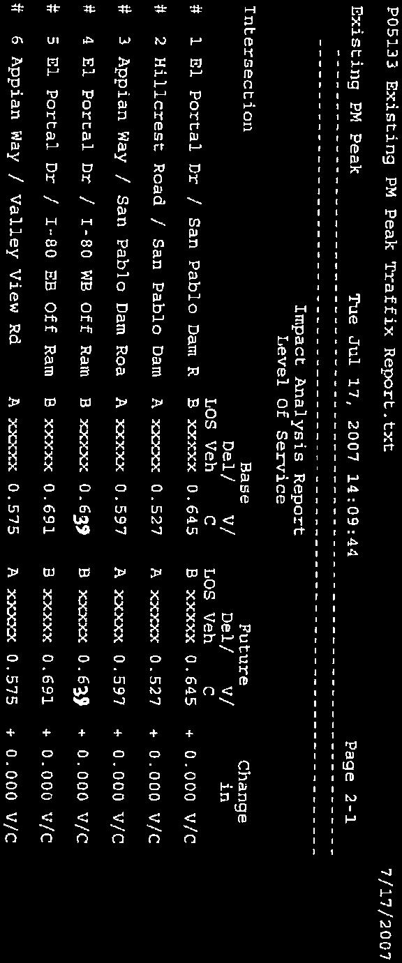
64 Page 3-18 Second paragraph remove the last sentence and replace with the following sentence: It should be noted that El Sobrante residents rejected any annexation to the City of Richmond some time ago. City of Richmond The Project Area is located within the "Sphere of Influence" of the City of Richmond. The Sphere of Influence is a geographical boundary line established by the Contra Costa Local Agency Formation Commission (LAFCO). The Sphere of Influence is generally the area to which the applicable agency, in this case the City of Richmond, is expected to eventually expand in terms of jurisdiction and responsibility for providing urban services. While the City of Richmond may eventually expand to include the Project Area, planning and land entitlement approvals for the Project Area continue as functions of the County, and the Board of Supervisors. There is no proposal at this time from the City of Richmond to annex the Project Area. It should be noted that El Sobrante residents rejected any annexation to the City of Richmond some time ago. Page 3-39 Table Table EXISTING VERSUS EXISTING PLUS PROJECT INTERSECTION LEVELS OF SERVICE Existing (v/c ratio / LOS) Existing + Project (v/c ratio / LOS) Study Intersection AM PM AM PM 1. San Pablo Dam Rd / El Portal Dr 0.65 / B 0.65 / B 0.74 / C 0.82 / D 2. San Pablo Dam Rd / Hillcrest Rd 0.49 / A 0.53 / A 0.54 / A 0.63 / B 3. San Pablo Dam Rd / Appian Way 0.72 / C 0.60 / A 0.84 / D 0.76 / C 4. El Portal Dr / I-80 WB Ramps 0.42 / A 0.64 / B 0.45 / A 0.68 / C B 5. El Portal Dr / I-80 EB Ramps 0.39 / A 0.69 / B 0.43 / A 0.75 / C 6. Appian Way / Valley View Dr a 0.51 / A 0.58 / A 0.54 / A 0.64 / B Note: a Although this intersection is striped as two through lanes and one right-turn pocket in the southbound direction, it operates and was therefore analyzed as one through lane and one rightturn lane. This assumption is based on the approaching lanes and their geometry, given right approaching lane is relatively short in length. Source: CCTALOS based on Technical Procedures, CCTA, July 19, Downtown El Sobrante General Plan Amendment Final EIR Page IV-2
65 Page 3-41 Third paragraph remove Error! Bookmark not defined. Since the boundaries of the GPA fall within several TAZs and the model already assumes some growth in these TAZs, a detailed review of the land uses was conducted to estimate what portion of the growth was attributed to the GPA and what portion was outside of the GPA but within the TAZ. Table on page 3-41Error! Bookmark not defined. shows the total household and employment numbers for each CCTA TAZ within the GPA area. The trip generation process is handled by the CCTA model including the daily, AM peak hour, and PM peak hour trips. Table revise table subheadings to read 2003 rather than Land Use Total GPA Project Land Use Total CCTA TAZ Year 2000 Year 2000 Year 2030 MF Year 2030 Total 2003MF 2003Total Households Employment Households Employment , , Total 4,585 2,360 5,329 2,827 MF Multi-family Households. Page Third Paragraph replace East Bay Municipal Utility District under Park and Recreation Facilities: and add East Bay Regional Park District. Public services in the Project Area are provided by the following entities: Water: East Bay Municipal Utility District (EBMUD) Wastewater: West County Wastewater District (WCWD) Solid Waste: (disposal and collection services are privately owned) Electricity and Natural Gas: Pacific Gas & Electric (PG&E) Fire Protection: Contra Costa County Fire Protection District (CCCFPD) Police Services: Contra Costa County Office of the Sheriff (CCCOS) Schools (K-12): West Contra Costa Unified School District (WCCUSD) Parks and Recreation Facilities: East Bay Municipal Utility District (EBMUD) East Bay Regional Park District (EBRPD) County Service Area 9 City of Richmond, and West Contra Costa Unified School District (Joint Use Facilities) Downtown El Sobrante General Plan Amendment Final EIR Page IV-3
66 Page Fifth paragraph change date in second sentence from 2009 to Appendix A In response to this concern, the District initiated the Freeport Regional Water Project with the County of Sacramento. Scheduled for completion in , this project will convey up to 100 MGD of Sacramento River water to the District s Mokelumne Aqueduct system during dry years. With the Freeport Regional Water Project in place, the drought limit of 25 percent rationing will continue in the future. Traffic Data Supplemental Transportation Analysis for El Sobrante General Plan Amendment (Dowling Associates, 2005), including Level of Service computation worksheets. This report was cited in the traffic analysis section to the Draft EIR released in November 2009, but it was inadvertently omitted during the printing of the Draft EIR. Downtown El Sobrante General Plan Amendment Final EIR Page IV-4
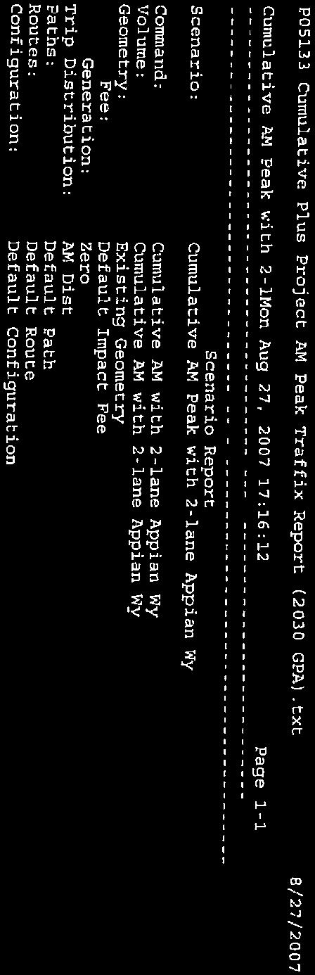
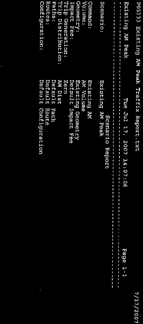
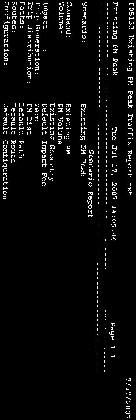
67 ERRATA APPENDIX A Supplemental Transportation Analysis for El Sobrante General Plan Amendment (Dowling Associates, 2005), including Level of Service computation worksheets. Downtown El Sobrante General Plan Amendment Final EIR Page IV-5
68
69

70
71
72
73
74
75
76
77
78

79


80


81


82
83
84
85
86
87
88
89
90
91

92
93
94

95
96
97

98

99

100
101
102
103
104
105
106
107
108

109
110
111

112
113
114
115

116

117
118
119

120
121
122
123

124
125