GOOD NEIGHBOR POLICY
|
|
|
- Betty Ryan
- 6 years ago
- Views:
Transcription
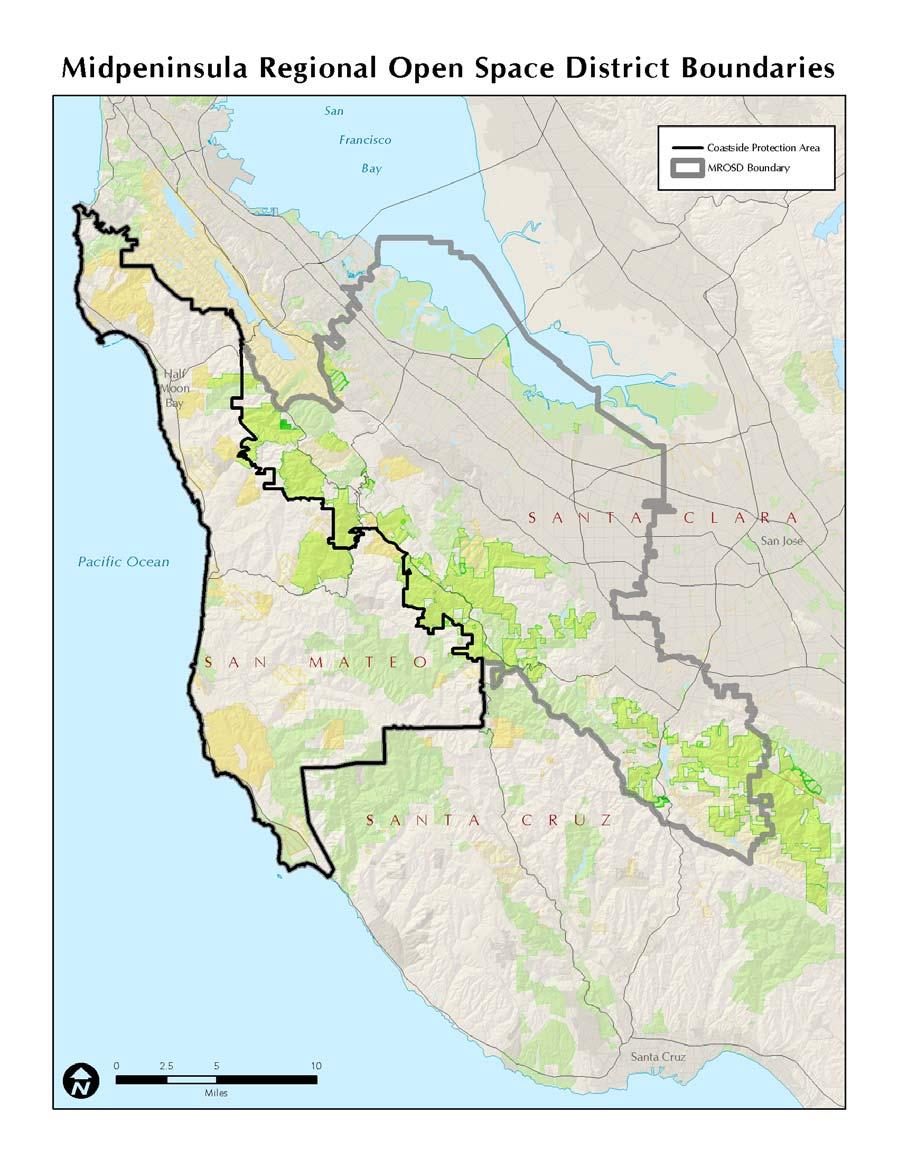
1 Regional Open Space MIDPENINSULA REGIONAL OPEN SPACE DISTRICT GOOD NEIGHBOR POLICY Adopted by the Board of Directors October 26, 1988 Amended August 14, 1996 Amended September 26, 2007 Introduction The mission of the District is: to acquire and preserve a regional greenbelt of open space land in perpetuity; protect and restore the natural environment; and provide opportunities for ecologically sensitive public enjoyment and education. The mission of the Coastside Protection Program is: To acquire and preserve in perpetuity open space land and agricultural land of regional significance, protect and restore the natural environment, preserve rural character, encourage viable agricultural use of land resources, and provide opportunities for ecologically sensitive public enjoyment and education. The Midpeninsula Regional Open Space District (District) is committed to building and maintaining good relationships with all its neighbors 1. To demonstrate this commitment, the District s Board of Directors adopted a Good Neighbor Policy in Since the last revision to the District s Good Neighbor Policy in 1996, the Local Agency Formation Commission (LAFCo) approved the District s Coastside Protection Program, in 2004, and expanded the District s boundary to include coastal San Mateo County from the southern boundary of the city of Pacifica to the Santa Cruz County line. This geographic area is called the Coastside Protection Area 2. In conjunction with LAFCo s approval, the Board of Directors adopted a Service Plan 3 for the Coastside Protection Program, which outlines the preservation and management services that will be provided by the District in the Coastside Protection Area. A specific condition of the LAFCo-approved Service Plan required the District to amend its Good Neighbor Policy to include the key Service Plan policies, guidelines and implementation actions which relate to the enjoyment of privacy on adjoining private lands and public involvement in policy development, as well as in the use and management decision-making process. This policy consists of 13 policy provisions, which meet the requirements of the Service Plan for the Coastside Protection Program and implement the specific LAFCo condition which the District s Board adopted by Resolution No on May 26, In Section 1 on the following pages each of the 13 Service Plan and LAFCo provisions (shown in italics) includes an implementation guideline (shown in bold), which describes how the District will carry out each provision and which in some cases supplements the provision. (While the Good Neighbor Policy provisions apply District-wide, some provisions were designated by LAFCo to apply to the coastside only. Where this is the case, the term Coastside Protection Area only has been added to the relevant implementation guideline). In addition, Sections 2 and 3 of this policy have a number of provisions that are based on input given to the District by neighbors during a series of public meetings throughout the District. 1 Neighbor Residents and property owners located adjacent or close to a District preserve who may be affected by maintenance or visitor activities on the preserves. 2 Coastside Protection Area Please see a map on the last page. The area extends from the southern border of the City of Pacifica southerly to the San Mateo/Santa Cruz County line and westerly from the existing District preserves along Hwy 35 (Skyline Blvd.). 3 Service Plan The District s plan for the Coastside Protection Program on the San Mateo County coast, which outlines preservation and management services that will be provided by the District.
2 For general information and comments neighbors can call, fax, or Midpeninsula Regional Open Space District 330 Distel Circle, Los Altos, California Phone: (650) Fax: (650) Purpose The purpose of the Good Neighbor Policy is to establish guidelines and principles for ensuring good relationships between the District and its neighbors. In both the day-to-day conduct and in the long-range planning for public open space preserves, the District will make every effort to cooperate with neighbors, to take into account their perspectives, address their concerns, and engage and involve them in the process of making decisions regarding the public preserves. GOOD NEIGHBOR POLICY SECTION 1: PUBLIC PARTICIPATION AND PRIVACY Many of the provisions in this section discuss public participation and notification and explain how the District will provide opportunities for neighbors to participate in decisions which may affect neighboring private lands and how the District will seek to notify them of these opportunities. To the District, being a good neighbor is a public-private partnership. Policy Provision 1 The District relies on public participation to complete its planning process for District preserves. For example, during the development of a master plan, the District holds a series of public workshops to obtain public input on access improvements and resource protection. Adjoining neighbors receive notifications about these meetings. Information about the meetings will also be available on the District s website. The District shall institute appropriate forms of representation so that the District planning and decision-making relating to the Coastside Protection Area includes the input of Coastside residents. Implementation Guideline 1 The District s Board of Directors voted on November 9, 2004 to approve a final redistricting plan and expand District Wards 6 and 7 to represent about 30,000 constituents in the Coastside Protection Area. In addition, the Board will publicly review District Ward boundaries after each official United States census and redistrict as necessary. Policy Provision 2 The District shall establish advisory committees, task forces or work groups as needed to develop or review specific policies or plans. Implementation Guideline 2 When planning for large-scale or complex projects public input is particularly valuable. Advisory committees, task forces or work groups can help assist the District in developing specific policies or plans. The Board will take the lead in creating these groups and welcomes suggestions by the community on when and how to best form them. Workshops with neighbors and the general public are a good way to discuss items of a controversial nature or significant changes in land-use or planning. 2
3 Policy Provision 3 (Coastside Protection Area only) To ensure that local viewpoints are considered in all significant District planning and decision-making relating to the Coastside Protection Area, the District shall consult with local elected officials, government agencies, and government-sponsored organizations within the Coastside Protection Area including, but not limited to the Midcoast Community Council, Pescadero Municipal Advisory Council, Half Moon Bay City Council and their elected bodies. Implementation Guideline 3 The District will establish a database of elected officials, government agencies, and government-sponsored organizations it will consult with on all significant planning and decision-making. Such consultations may occur through written questionnaires or requests for comments. Policy Provision 4 The Coastside Protection Area covers the San Mateo County coast from south of the City of Pacifica to the Santa Cruz County line. To further ensure recommendations representing local involvement are considered in District planning and decision-making relating to the Coastside Protection Area, the District shall directly notify community-interest groups, non-profit land trusts, elected officials, and other interested organizations about District Board meetings or other public meetings that involve subjects relating to the District s activities within the Coastside Protection Area. Implementation Guideline 4 The Coastside Protection Program s goal is to permanently protect open space and agricultural land. Participation by local citizens is of critical importance to the District. Therefore, the District will encourage citizen involvement by notifying neighboring property owners, neighborhood organizations and interested individuals of upcoming Board meetings, special meetings, or workshops as established in the District s Public Notification Policy. The District shall also use other methods of notification to provide opportunities for public input such as announcements required by law, press releases, the District s Web site, , local newspapers, local bulletin boards, articles, print ads, and special mailings to interested individuals. Efforts will be made to notify the public a minimum of one week in advance of a public meeting. For single-subject meetings of the full Board of Directors, or for meetings of standing Board committees for which the agendas are set well in advance, notices will be sent out to the public at least two weeks before the meetings, if possible. 3
4 Policy Provision 5 In addition to adopted and legally required noticing, the District shall notify owners of contiguous properties about public meetings where property acquisitions in the Coastside Protection Area or any significant use or improvements proposed on District-owned lands in the Coastside Protection Area are considered. Implementation Guideline 5 For meetings where land purchases or land management agreements are being considered, the District will notify owners of adjacent properties and other affected neighbors in the vicinity (e.g. within the watershed or road corridor) of a proposed purchase or agreement. The District will also notify owners of adjacent properties and other affected neighbors in the vicinity (e.g. within the watershed or road corridor) of District preserves when significant changes in use or improvements those that have a potentially major effect on the area are proposed on District-owned lands. Policy Provision 6 Because each land use management plan, policy update, acquisition project and significant capital improvement project is subject to full review by the District Board (Page 23 of service plan), meetings of the District Board and/or subcommittees on such matters concerning Coastside Protection Area territory shall be held in the Coastside Protection Area. Implementation Guideline 6 The Board of Directors and/or Board committees will hold public meetings in the affected area of the District when they consider master plans and/or significant policies which are those policies that could have a major or important effect on the area. Policy Provision 7 The District shall provide private property signs where appropriate and provide trail users information regarding private property boundaries and to prohibit trespass to minimize public/private use conflicts and trespassing. The District shall clearly sign trails adjacent to active agriculture and provide trail users with information regarding property boundaries to minimize trespassing and conflicts with agricultural users. Implementation Guideline 7 The District will install private property signs, where appropriate, and provide trail users with preserve maps and other information to help identify private property boundaries and help protect the privacy of District neighbors. To further inform trail users, where appropriate, the District will also post signs along trails adjacent to active agricultural land. 4
5 Policy Provision 8 Use and Management Plans balance opportunities for public recreation with natural resource protection through a comprehensive planning approach in partnership with the community. The following measures will be included in every future Use and Management Plan for parcels within the Coastside Protection Area: a. In areas where trail routes are immediately adjacent to private property, fencing shall be employed as necessary to deter users from leaving the trail. Specific fence, gate, and crossing designs will be determined in consultations with adjacent affected property owner(s) at the Use and Management Plan stage. b. All new trails/facilities shall be sited away from the edges of new preserves to the greatest extent possible. All new trails/facilities will be designed to preserve existing vegetation within new preserves and at the property lines so that views of land uses in adjacent residential properties would be minimized. c. Trails shall be sited a minimum distance of 300 feet from occupied dwellings unless site-specific circumstances make this infeasible. Where a 300-foot setback is not feasible, trails shall be set back a minimum distance of 50 feet. Potential noise and privacy impacts must be evaluated for any subsequent District action and shall be reduced by berms, fencing, landscaping, and other feasible and compatible means, if necessary. Implementation Guideline 8 The District will consider neighbors concerns including the desire for privacy on properties that adjoin District lands, and assist with the prevention of unintentional trespass by preserve visitors through the following: 8.1 Evaluate potential noise and privacy impacts when planning trails and facilities adjacent to private property. Reduce potential noise or privacy impacts with berms, fencing, landscaping, and other feasible and compatible means, if possible Carefully conduct District business (such as performing maintenance or installing fencing) to avoid encroachment on adjacent private property. If a neighbor believes that the District is encroaching on adjacent private property, he or she should notify the District as soon as possible. 8.3 Site new trails and facilities away from private property boundaries, to the extent possible, and design trails to preserve existing vegetation and to minimize views of adjacent residential properties land uses. An effort will be made to site new trails 300 feet from occupied dwellings on neighboring properties, to the extent feasible. If infeasible, the District will seek to maintain a minimum setback of 50 feet. Fencing or visual screens may be used by the District to prevent trespassing in rare cases when trails are located directly adjacent to private property. 5
6 Policy Provision 9 (Coastside Protection Area only) Upon completion of the annexation process and with public involvement through local groups, the District shall conduct public hearings to develop its Basic Policies for the Coastside Protection Area. These hearings shall address, at a minimum, the following topics: public participation; resource management; public access; recreational use; public safety; cultural resources; agricultural and timber production; interagency relationships; and public information. Implementation Guideline 9 Individuals, local groups and organizations will be consulted through a process that will involve public meetings and offer ample other opportunities, such as , to provide input concerning the development of Basic Policies specific to the Coastside Protection Area. Policy Provision 10 (Coastside Protection Area only) As noted in 6 above, all proposed Coastside Protection Area policies shall be considered by the full Board of Directors at public meetings held in the Coastside Protection Area. Implementation Guideline 10 The Board of Directors will hold public meetings in the Coastside Protection Area, as necessary, when policy changes specifically affect the coast. Policy Provision 11 (Coastside Protection Area only) In addition to the District s Planning Manager, neighbors may also contact the District s Ombudsperson who is an independent appointee of the Board of Directors. The Ombudsperson follows up on resident and neighbor inquiries or complaints to attempt and resolve misunderstandings or conflicts that have not been resolved satisfactorily by District staff. A District staff liaison will be assigned to the Coastside Protection Area to work with local residents, property owners, government, and interest groups in developing recommendations to the District Board of Directors. Implementation Guideline 11 The District s Planning Manager is the primary staff liaison to work with local residents, property owners, local elected officials, government agencies, and neighborhood and other interest groups in developing recommendations for the District s Board of Directors. Policy Provision 12 The Legislative, Finance, and Public Affairs Committee, a Standing Committee of the Board, shall at an annual public meeting review the Good Neighbor Policy and its implementation and effectiveness. The Good Neighbor Policy shall be amended as necessary to ensure the best possible relationship between the District and its neighbors. 6
7 Implementation Guideline 12 The District will review the Good Neighbor Policy annually at a public meeting of the District s Legislative, Funding and Public Affairs Committee, the location of which will be rotated among different sites in the District, to ensure its continued effectiveness and implementation. Based on input from the public, the Board will amend the Policy, as necessary, to ensure the best possible relationship between the District and its neighbors. Throughout the year, the District will also gather information and suggestions that neighbors provide to staff in person or send in via the Web site, or regular mail. Policy Provision 13 The District currently uses a variety of techniques to reduce fire danger on its preserves, supports livefire training efforts, and coordinates with other local fire agencies for training and response. In the event of a fire on District preserves or neighboring lands, neighbors should always contact local fire emergency services first by calling 911. The District shall develop a Good Neighbor Brochure and shall update it regularly and distribute it to property owners with land adjoining District Preserves. The Brochure shall contain the following information: 1. Emergency contact information for District and other agencies by nature of emergency (fire, flooding, medical, illegal activity, abandoned vehicles, etc.) 2. District contact for resource management (weed abatement, feral animal control, restoration and re-vegetation, etc.) 3. District contact for fire and hazard prevention (fuel management, information regarding fire-safe practices, fallen or hazardous trees, etc.) 4. District contact for conflicts between neighbors and Preserve visitors (trespass, parking, noise, etc.) 5. District contact for general questions regarding use and management of Preserves 6. How to make a suggestion or file a complaint regarding use and management of District Preserves or the District s operation in general (phone, write, , in person) Contact information for Ombudsperson Management and Board of Director contact information Website mailbox Office hours and location Board meeting dates and times 7. Copy of the Good Neighbor Policies Implementation Guideline 13 The District will develop and periodically update a Board-approved Good Neighbor Brochure, which will include all the items listed under Policy Provision 13 above, among others. At the annual public meeting to review the Good Neighbor policy, input on the brochure will also be solicited and the Board will be fully informed of constituents recommendations. The Brochure will be made available to neighbors. SECTION 2: LAND PURCHASE, PLANNING AND MANAGEMENT The District will encourage neighbors to provide input in the following ways: 1. For potential new land purchases or land transfers and management agreements, the District will notify adjoining property owners of Board and Board Committee meetings where issues such as access to the new property and changes to existing 7
8 land uses will be discussed. For significant or coastside purchases, the Real Property Committee will conduct public on-site meetings which may occur on weekends. 2. The District will evaluate access to newly acquired land by neighbors on a case-bycase basis to ensure public safety and determine whether access is compatible with District ordinances and low-impact recreation. To the extent feasible, the District will consider continuing access through a permit system managed by the District. 3. In managing District preserves, to the extent possible, the District will a. Control non-native vegetation and animals and initiate cooperative efforts with neighbors to control non-natives on lands adjacent to District preserves. b. Minimize the impact on native plants when removing invasives. c. Consider neighbors desire to preserve the natural landscape viewshed. d. Cooperate with local and state fire officials on emergency response and fire prevention. e. Implement its resource management policies. The Good Neighbor Brochure includes key contact and emergency phone numbers such as whom to contact regarding non-native vegetation on neighboring properties, and to whom neighbors can report observed violations of District ordinances on preserve lands. The brochure also contains important information on how the District operates with respect to neighboring properties. Examples of this type of information include the roles of the District s Rangers and how the District cooperates with fire officials in the event of a fire. SECTION 3: PUBLIC INFORMATION, EDUCATION AND OUTREACH District staff will provide information to educate neighbors about the District, its mission, events and activities. Interaction with neighbors through outreach is one way to provide services to them. The following provisions will guide the District s public education and outreach to neighbors: 1. Following close of escrow of land purchased, the District will acquaint new neighbors with policies and ordinances by providing each adjacent property owner with a letter of introduction, and a copy of the District s basic policies and ordinances. 2. Generally represent the District in the community by attending local community meetings and contacting neighbors on relevant issues, as appropriate. 3. Provide information through a variety of means such as the District s Web site, e- mail, quarterly newsletter, and signboards, among others. 4. Make reasonable efforts to address and resolve situations that may arise between neighbors and the District. The District may also respond to specific neighborhood concerns by holding office and/or site meetings, as needed. 5. The Board has appointed an Ombudsperson to assist the public with their interactions with the District and facilitate the resolution of conflicts. The Ombudsperson works independently and objectively to assist in maintaining positive relations with District residents and neighbors. Contact information for the Ombudsperson is listed in the Good Neighbor Brochure. OTHER RELEVANT DISTRICT POLICIES Below is a list of specific policies approved by the Board of Directors that provide additional direction on many aspects of District business and complement the Good Neighbor Policy: 1. The existing Basic Policy provides public information about the mission, purpose, strategic direction, and major elements of the District s operations. 2. The Public Notification Policy ensures that reasonable and timely efforts are made 8
9 to notify surrounding landowners and interested members of the public of District activities. 3. Land Acquisition Policies and Procedures offer information about land purchases. This also includes the restrictive policy under which the District may use eminent domain to purchase private land at fair market value. Eminent domain in the Coastside Protection area has been permanently removed as a District power by California state law under an agreement with the San Mateo County Farm Bureau. 4. Resource Management Policies establish techniques to restore the natural environment and define the practices to protect and manage resources including managing vegetation, encouraging native plants, controlling non-native plants and animals, agricultural practices, and use of fire as a land management tool. 5. Use and Management Planning Process is a public process to develop use and management policies for District lands to protect the natural environment and provide opportunities for ecologically sensitive public enjoyment and education. 6. The District is developing an Encroachment Policy. This policy will educate District neighbors and users of open space areas about activities that are not allowed on District land, or allowed only by permit. The policy s goal is to protect public lands from encroachment. Examples of encroachments are a fence or trail that has been placed on District lands without permission. 7. The policies for Road Maintenance Agreements describe the parameters under which the District will enter into road agreements, including cost-sharing and other arrangements. In the near future the Midpeninsula Regional Open Space District will develop or amend a number of public policies and policy documents. For example, the District s Public Notification Policy and its Basic Policy will both be revised and a set of Basic Policies will be developed for the San Mateo County coastside. LEGAL NOTE The purpose of this Policy is to promote good relationships with the District s neighbors by providing guidance to the District and to the public on how to best build and maintain positive relationships. This Policy represents the District s commitment to the principles contained in it. Government agencies like the District are subject to many legal requirements in carrying out its mission. It s not the purpose of this Policy to adopt new legal requirements but rather to supplement what the law already requires with a set of additional standards to which the District is publicly committed. No action taken by the District will be invalid merely for a failure to comply with this Policy. 9
10
BOARD POLICY NO. 025 PUBLIC PARTICIPATION PLAN POLICY. Purpose
 BOARD POLICY NO. 025 PUBLIC PARTICIPATION PLAN POLICY Purpose This policy establishes a process for obtaining input from and providing information to the public concerning agency programs, projects, and
ATTACHMENT 2A- Issues Tentatively Resolved Decisions from the Board of Supervisors Hearing on September 11, 2007
 1. Introduction (on pg 1-15) Add the following goal: A Community safe from climate change. Marin will be a leader in averting and adapting to aspects of climate change. 2. Biological Resources 2.A. Richardson
Neighborhood and Homeowner Association Registration Policy
 Neighborhood and Homeowner Association Registration Policy The purpose of this document is to help ensure the functionality of Neighborhood Associations as well as the effectiveness of the services provided
REQUEST FOR PROPOSALS EXECUTIVE SEARCH SERVICES. Issuance Date November 27, 2017
 REQUEST FOR PROPOSALS EXECUTIVE SEARCH SERVICES Issuance Date November 27, 2017 Submittal Deadline January 8, 2018 Page Is Blank For Photocopying MARIN LAFCO 2 TABLE OF CONTENTS Section Page Number I.
Town of Lincoln COMPREHENSIVE PLANNING PUBLIC PARTICIPATION PLAN. Prepared by the Town of Lincoln Plan Commission
 COMPREHENSIVE PLANNING Prepared by the Town of Lincoln Plan Commission Adopted by the Town of Lincoln Town Board November 2007 With assistance from: TOWN OF LINCOLN COMPREHENSIVE PLANNING PURPOSE Public
Plan of Conservation and Development
 Plan of Conservation and Development Background: At least once every ten years each municipality s Planning Commission is required by state law to update its Plan of Conservation and Development (POCD).
SANTA BARBARA COUNTY ZONING ADMINISTRATOR STAFF REPORT October 21, 2011
 SANTA BARBARA COUNTY ZONING ADMINISTRATOR STAFF REPORT October 21, 2011 PROJECT: Gilson Move Dwelling HEARING DATE: November 7, 2011 STAFF/PHONE: J. Ritterbeck, (805) 568-3509 GENERAL INFORMATION Case
10.2 RESPONSIBILITIES 10.1 IMPLEMENTATION PROCESS. City Council. Planning Commission
 10 IMPLEMENTATION The 2035 General Plan provides specific policy guidance for the implementation of plan concepts in each of the Plan elements. This framework establishes a basis for coordinated action
Chapter 750 WIND POWER GENERATION FACILITIES
 Chapter 750 WIND POWER GENERATION FACILITIES 750.01 Purpose 750.02 Definitions 750.03 Designated Areas 750.04 Permitted Uses 750.05 Conditional Uses 750.06 Construction Standards 750.07 Application Requirements
Chapter 11 Intergovernmental Coordination and Implementation
 Chapter 11 Intergovernmental Coordination and Implementation Regional Framework Plan Vision In the year 2020, Lake County will have developed cooperation between County, municipal, township, and other
Notice of Intent for New or Renewal of General Permit for Discharges from Small MS4s Preamble
 Preamble PREAMBLE to NOTICE OF INTENT FOR NEW OR RENEWAL OF GENERAL PERMIT FOR DISCHARGES FROM SMALL MUNICIPAL SEPARATE STORM SEWER SYSTEMS - MS4S describing LAKE COUNTY S COUNTYWIDE APPROACH TO STORMWATER
SAN LUIS OBISPO COUNTY COMMUNITY ADVISORY COUNCIL HANDBOOK
 SAN LUIS OBISPO COUNTY COMMUNITY ADVISORY COUNCIL HANDBOOK TABLE OF CONTENTS PURPOSE OF THIS HANDBOOK 1 WHAT IS A COMMUNITY ADVISORY COUNCIL? 2 Board of Supervisors Resolution 2 THE ROLE & ACTIVITIES OF
(1) The proposed commercial solar energy generation facility is either
 The proposed commercial solar energy generation facility is either") (2) The design and siting of these facilities shall avoid the placement of turbines on or immediately adjacent to the upwind side of ridge crests; (3) The design may include other design features to minimize
(2) The design and siting of these facilities shall avoid the placement of turbines on or immediately adjacent to the upwind side of ridge crests; (3) The design may include other design features to minimize
CHARTER TOWNSHIP OF PORT HURON
 CHARTER TOWNSHIP OF PORT HURON 3800 Lapeer Road Phone: (810) 987-6600 Port Huron Twp., Michigan 48060 Fax: (810) 987-6712 www.porthurontownship.org KLavigne@PortHuronTownship.org MEMORANDUM To: Chairman
MEMORANDUM AGENDA ITEM #4b
 South Florida Regional Planning Council MEMORANDUM AGENDA ITEM #4b DATE: AUGUST 3, 2009 TO: FROM: SUBJECT: EXECUTIVE COMMITTEE STAFF CITY OF CORAL GABLES PROPOSED COMPREHENSIVE PLAN AMENDMENT Introduction
Protocol for Developing Multi-Stakeholder Group Terms of Reference and Internal Governance Rules and Procedures
 Protocol for Developing Multi-Stakeholder Group Terms of Reference and Internal Governance Rules and Procedures February 2015 Protocol for Developing Multi-Stakeholder Group Terms of Reference and Internal
SANTA CRUZ LOCAL AGENCY FORMATION COMMISSION SPHERES OF INFLUENCE POLICIES AND GUIDELINES
 SANTA CRUZ LOCAL AGENCY FORMATION COMMISSION SPHERES OF INFLUENCE POLICIES AND GUIDELINES I. Legislative Authority Amended by Resolution No. 2011-1; February 2, 2011 The Knox-Nisbet Act of 1963 (former
SECTION 4.0 CONSISTENCY WITH PLANS AND POLICIES MOU PROJECT
 SECTION 4.0 CONSISTENCY WITH PLANS AND POLICIES MOU PROJECT 4.1 RELATIONSHIP TO CEQA Section 4.0 The following discussion of County policies and the preliminary determinations regarding the consistency
AGENDA Tuesday, September 29, 2015
 9/24/15 Page 1 of 1 GRAND COUNTY COUNCIL SPECIAL MEETING ADMINISTRATIVE WORKSHOP Grand County Council Chambers 125 East Center Street, Moab, Utah AGENDA Tuesday, September 29, 2015 9:00 a.m. WORKSHOP Call
INTERMUNICIPAL DEVELOPMENT PLAN. Ponoka County / Town of Rimbey PONOKA COUNTY BYLAW NO IDP TOWN OF RIMBEY BYLAW NO. 954/19
 INTERMUNICIPAL DEVELOPMENT PLAN Ponoka County / Town of Rimbey PONOKA COUNTY BYLAW NO. 8-19-IDP TOWN OF RIMBEY BYLAW NO. 954/19 MARCH 20, 2019 Page 2 of 18 TABLE OF CONTENTS TABLE OF CONTENTS... 2 A. INTRODUCTION...
RESOLUTION. Councilperson De Bonis, seconded by Councilperson Murphy, introduced the following proposed local law, to be known as Local
 RESOLUTION Councilperson De Bonis, seconded by Councilperson Murphy, introduced the following proposed local law, to be known as Local Law No. of 2018, entitled A LOCAL LAW OF THE TOWN OF WASHINGTON, DUTCHESS
ARTICLE 38: AIR QUALITY ASSESSMENT AND VENTILATION REQUIREMENT FOR URBAN INFILL RESIDENTIAL DEVELOPMENTS
 San Francisco Health Code ARTICLE 38: AIR QUALITY ASSESSMENT AND VENTILATION REQUIREMENT FOR URBAN INFILL RESIDENTIAL DEVELOPMENTS Sec. 3801. Sec. 3802. Sec. 3803. Sec. 3804. Sec. 3805. Sec. 3806. Sec.
PROPOSED AMENDMENT TO COMMISSION POLICY 22 AGRICULTURAL PRESERVATION POLICY
 EXECUTIVE OFFICER S AGENDA REPORT MARCH 27, 2019 TO: FROM: SUBJECT: LAFCO Commissioners Sara Lytle-Pinhey, Executive Officer PROPOSED AMENDMENT TO COMMISSION POLICY 22 AGRICULTURAL PRESERVATION POLICY
Architectural Review Board Report
 Architectural Review Board Report To: From: Subject: Architectural Review Board Architectural Review Board Meeting: June 15, 2015 Steve Traeger, Principal Urban Designer Grace Page, ARB Liaison Agenda
Chapter 1 Introduction
 ExhibÌt 2b Ðraft Background Report - chapter 1 lntroduction CountY of Ventura Planning Cómmiásion Work Session #3 ' * PLz-0141- Agenda ltem 6 ein oit 2b - Draft Background léóãtt - ChaPter I lntroduction
FERRY COUNTY COUNTY-WIDE PLANNING POLICIES
 FERRY COUNTY COUNTY-WIDE PLANNING POLICIES This memorandum of understanding lays out the framework upon which the comprehensive planning process for Ferry County and the City of Republic will be built.
1.0 Introduction. 1.1 Project Background
 Gaviota Coast Plan Final EIR This chapter provides an overview of the Environmental Impact Report (EIR) for the proposed Gaviota Coast Plan (proposed Plan). The proposed Plan is described in detail in
REPORT TO PLANNING AND DESIGN COMMISSION City of Sacramento
 REPORT TO PLANNING AND DESIGN COMMISSION City of Sacramento 915 I Street, Sacramento, CA 95814-2671 4 To: Members of the Planning and Design Commission: PUBLIC HEARING May 11, 2017 Subject: Capital City
CITY OF CHELAN GROWTH MANAGEMENT ACT PUBLIC PARTICIPATION PLAN. Introduction
 CITY OF CHELAN GROWTH MANAGEMENT ACT PUBLIC PARTICIPATION PLAN March 10, 2016 Introduction One cornerstone for the success of the Growth Management Act (GMA) is citizen participation. That concept is first
SUMMIT ROAD SOCIETY (INC.) JOB DESCRIPTION EXECUTIVE SECRETARY
 JOB DESCRIPTION EXECUTIVE SECRETARY") SUMMIT ROAD SOCIETY (INC.) JOB DESCRIPTION 1. Background EXECUTIVE SECRETARY This is a position for a self-employed person with management, office accounting, secretarial and strong interpersonal skills.
SUMMIT ROAD SOCIETY (INC.) JOB DESCRIPTION 1. Background EXECUTIVE SECRETARY This is a position for a self-employed person with management, office accounting, secretarial and strong interpersonal skills.
STANISLAUS LOCAL AGENCY FORMATION COMMISSION OUT-OF-BOUNDARY SERVICE APPLICATION 310 RIVER ROAD & 240 BUNKER AVENUE (MODESTO SEWER SERVICE)
") EXECUTIVE OFFICER S AGENDA REPORT APRIL 25, 2018 STANISLAUS LOCAL AGENCY FORMATION COMMISSION OUT-OF-BOUNDARY SERVICE APPLICATION 310 RIVER ROAD & 240 BUNKER AVENUE (MODESTO SEWER SERVICE) APPLICANT: City
EXECUTIVE OFFICER S AGENDA REPORT APRIL 25, 2018 STANISLAUS LOCAL AGENCY FORMATION COMMISSION OUT-OF-BOUNDARY SERVICE APPLICATION 310 RIVER ROAD & 240 BUNKER AVENUE (MODESTO SEWER SERVICE) APPLICANT: City
Report by City of Atlanta Ethics Officer on First Two Years of Operation August 13, June 30, 2005
 Report by City of Atlanta Ethics Officer on First Two Years of Operation August 13, 2003 - June 30, 2005 The Ethics Officer in conjunction with the City of Atlanta s Board of Ethics proposed a work plan
TABLE OF CONTENTS CHAPTER STATUTORY AUTHORIZATION...
 TABLE OF CONTENTS CHAPTER 1... 1 STATUTORY AUTHORIZATION... 1 Subdivision 1. Adoption by Reference of State Regulations.... 1 Subdivsion 2. Adoption by Reference of State Regulations.... 1 CHAPTER 2...
COASTAL CONSERVANCY. Staff Recommendation December 8, 2005 BALLONA WETLANDS ENHANCEMENT PLANNING. File No Project Manager: Mary Small
 COASTAL CONSERVANCY Staff Recommendation December 8, 2005 BALLONA WETLANDS ENHANCEMENT PLANNING File No. 04-088 Project Manager: Mary Small RECOMMENDED ACTION: Authorization to disburse up to $200,000
Introduction Page I-1 INTRODUCTION
 Introduction Page I-1 INTRODUCTION The Arcata General Plan: 2020 will help shape how the city of Arcata will look, function, provide services, and manage resources for the next 20 years. The plan is the
CHAPTER 3.0 CIRCULATION ELEMENT
 CHAPTER 3.0 CIRCULATION ELEMENT The Circulation Element identifies the general location and extent of existing and proposed major transportation facilities for vehicle, rail, air, water, and bicycle transportation
PUBLIC PARTICIPATION POLICY FOR PARK PLANNING
 PUBLIC PARTICIPATION POLICY FOR PARK PLANNING DEPARTMENT OF PARKS AND RECREATION CITY OF RALEIGH, NORTH CAROLINA May 14, 2012 Introduction The purpose of Raleigh Parks and Recreation Department is to actively
The Basics: What Communities Need to Know
 Shoreland & Floodplain Variance Guidance Series This document provides an overview of the statewide regulations governing development and land use along lakes and rivers; the roles of local governments
COASTAL CONSERVANCY. Staff Recommendation March 2, 2006 BALLONA WETLANDS ENHANCEMENT PLANNING. File No Project Manager: Mary Small
 COASTAL CONSERVANCY Staff Recommendation March 2, 2006 BALLONA WETLANDS ENHANCEMENT PLANNING File No. 04-088 Project Manager: Mary Small RECOMMENDED ACTION: Authorization to amend the Conservancy's December
Section 3.9 Land Use and Planning ENVIRONMENTAL SETTING
 Section 3.9 Land Use and Planning This section evaluates the existing land use setting and potential land use and planning impacts that may result from construction and/or operation of the proposed project.
Mount Airy Environs Community Comprehensive Plan
 Chapter 11: Community Involvement Goal Goals To increase citizen awareness of, and participation in planning issues, processes, and development decisions To increase public participation in government
PUBLIC PARTICIPATION PLANS IN WAUSHARA COUNTY
 PUBLIC PARTICIPATION PLANS IN WAUSHARA COUNTY Assembled by Patrick Nehring, UW-Extension Waushara County Based on the process used by East Central Regional Planning beginning in 1999 and on the 2002 Grant
(Added by Ord , File No , App. 7/3/2003) (Derivation Former Administrative Code Section 5.239; added by Ord , File No.
 (Derivation Former Administrative Code Section 5.239; added by Ord , File No.") CHAPTER 12: URBAN FORESTRY COUNCIL Sec. 1200. Purpose--Urban Forestry Council. Sec. 1201. Scope of Authority. Sec. 1202. Council Composition and Administration. Sec. 1203. Responsibilities. Sec. 1204.
CHAPTER 12: URBAN FORESTRY COUNCIL Sec. 1200. Purpose--Urban Forestry Council. Sec. 1201. Scope of Authority. Sec. 1202. Council Composition and Administration. Sec. 1203. Responsibilities. Sec. 1204.
Final Report of the Riparian Forest Buffer Panel
 Chesapeake Bay Program Final Report of the Riparian Forest Buffer Panel Introduction Findings Land Use-Specific Findings On Agricultural Land On Forested Land On Developed and Developing Lands Recommendations
Volume II Recommendations January 2006 City of Madison Comprehensive Plan
 11 INTERGOVERNMENTAL COOPERATION THE PLAN: GOALS, OBJECTIVES, POLICIES AND IMPLEMENTATION RECOMMENDATIONS Volume II Recommendations January 2006 TABLE OF CONTENTS Intergovernmental Overview...11 1 Summary
Notice of Intent for New or Renewal of General Permit for Discharges from Small MS4s Preamble
 Preamble PREAMBLE to NOTICE OF INTENT FOR NEW OR RENEWAL OF GENERAL PERMIT FOR DISCHARGES FROM SMALL MUNICIPAL SEPARATE STORM SEWER SYSTEMS - MS4S describing LAKE COUNTY S COUNTYWIDE APPROACH TO STORMWATER
NOTICE OF PUBLIC HEARING BYLAW 1413
 NOTICE OF PUBLIC HEARING BYLAW 1413 Pursuant to Section 631 of the Municipal Government Act, the Council of Camrose County gives notice that they have given First Reading to Camrose County By-law 1413
This page intentionally left blank
 Monterey County has elected to include an as part of the General Plan. Agriculture consisting of crop farming and livestock grazing is the largest industry in the County and contributes a significant amount
Chapter 13: Wildlife and Vegetation
 Chapter 13: Wildlife and Vegetation Introduction and Setting Nevada County contains an extremely wide range of plants, animals and habitat types. With topographic elevations ranging from 300 feet in the
WATERSHED MANAGEMENT INITIATIVE: GOALS & IMPLEMENTATION OBJECTIVES, JULY 26, 1999
 WATERSHED MANAGEMENT INITIATIVE: GOALS & IMPLEMENTATION OBJECTIVES, JULY 26, 1999 The following table indicates the draft goals and objectives for the Santa Clara Basin WMI process. The overall objectives
KENTUCKY UTILITIES SPECIAL USE AUTHORIZATION AMENDMENT: MOUNT VICTORY TRANSMISSION TOWER REPLACEMENT DECISION MEMO
 UNITED STATES DEPARTMENT OF AGRICULTURE FOREST SERVICE SOUTHERN REGION DANIEL BOONE NATIONAL FOREST KENTUCKY MARCH 2016 KENTUCKY UTILITIES SPECIAL USE AUTHORIZATION AMENDMENT: MOUNT VICTORY TRANSMISSION
City of Albuquerque Code of Ordinances
 PART 2: NEIGHBORHOOD ASSOCIATION RECOGNITION 14-8-2-1 SHORT TITLE. Sections 14-8-2-1 et seq. may be cited as the "Neighborhood Association Recognition Ordinance." ('74 Code, 7-11-1) (Ord. 14-1987) 14-8-2-2
DROPBOX, INC. CORPORATE GOVERNANCE GUIDELINES
 DROPBOX, INC. CORPORATE GOVERNANCE GUIDELINES (Adopted on February 22, 2018; Effective upon the effectiveness of the registration statement relating to the Company s initial public offering) The Board
Board of Directors Meeting Agenda Report
 Supplemental No. 1 AGENDA ITEM #10.B Distributed 6/21/18 Meeting Date: June 14, 2018 Board of Directors Meeting Agenda Report Subject: Initiated by: Previous Consideration: Fiscal Impact: Attachments Summary:
Chapter 5 - Transportation
 Chapter 5 - Transportation Discussion Similar to the other elements in the Comprehensive Plan, the transportation element impacts the quality of life, economic development and public safety of the residents
Request. Recommendation
 Administrative Hearing Staff Report CLEARWIRE CONDITIONAL USE Uintah School Rooftop Antenna PLNPCM2010-00193 1571 East 1300 South Hearing date: May 27, 2010 Planning Division Department of Community &
Town of Saratoga. Agriculture and Farmland Protection Plan
 Town of Saratoga Agriculture and Farmland Protection Plan EXECUTIVE SUMMARY Town of Saratoga Saratoga County, New York September 2018 Executive Summary Dramatic Changes in the Agricultural Landscape In
ESSENTIALS OF LAND USE PLANNING AND REGULATION
 1 ESSENTIALS OF LAND USE PLANNING AND REGULATION 1. Planning for a Vibrant Sustainable Community 2. Roles and Responsibilities 3. Implementing the Plan 4. Meetings, Hearings and Due Process 2 PLANNING
INTENT OBJECTIVES HISTORIC DESIGNATIONS
 TOWN OF LOS GATOS RESIDENTIAL DEVELOPMENT STANDARDS FOR ALL SINGLE FAMILY AND TWO-FAMILY DWELLINGS IN ALL ZONES EXCEPT THE RESOURCE CONSERVATION AND HILLSIDE RESIDENTIAL ZONES INTENT These development
WHEREAS, in the Borough of Ringwood includes 18,230 acres of land all of which is entirely in the Preservation Area; and ~ 4 ~
 WHEREAS, the New Jersey Highlands Region (Highlands Region) is an area of over 859,000 acres that consists of 88 municipalities in parts of seven counties Bergen, Hunterdon, Morris, Passaic, Somerset,
CITY OF PALO ALTO COUNCIL PROTOCOLS
 CITY OF PALO ALTO COUNCIL PROTOCOLS All Council Members All members of the City Council, including those serving as Mayor and Vice Mayor, have equal votes. No Council Member has more power than any other
Planning Commission: Local Coastal Program Update Land Use Overview. October 24, 2017
 Planning Commission: Local Coastal Program Update Land Use Overview October 24, 2017 Local Coastal Program Update: Agenda Coastal Act Framework Half Moon Bay s Certified LCP Considerations for the LCP
WHEREAS, in the Township of Denville 7 acres are in the Preservation Area and 8,155 acres are in the Planning Area; and ~ 4 ~
 WHEREAS, the New Jersey Highlands Region (Highlands Region) is an area of over 859,358 acres that consists of 88 municipalities in parts of seven counties Bergen, Hunterdon, Morris, Passaic, Somerset,
ADMINISTRATIVE DESIGN REVIEW (ADR) An applicant s guide to the process
 An applicant s guide to the process") City of Del Mar Phone: 858-755-9313 Fax: 858-755-2794 Department of Planning and Community Development Hours: M-TH 1:00 pm 5:30 pm 1050 Camino del Mar FRI 1:00 pm 4:30 pm Del Mar, CA 92014 Web: www.delmar.ca.us
City of Del Mar Phone: 858-755-9313 Fax: 858-755-2794 Department of Planning and Community Development Hours: M-TH 1:00 pm 5:30 pm 1050 Camino del Mar FRI 1:00 pm 4:30 pm Del Mar, CA 92014 Web: www.delmar.ca.us
Zoning Text Amendment
 Staff Report PLANNING DIVISION COMMUNITY & ECONOMIC DEVELOPMENT To: Salt Lake City Planning Commission From: Michael Maloy, AICP, 801.535.7118 Date: May 28, 2014 Re: PLNPCM2014-00085 Form Based Urban Neighborhood
SANTA BARBARA COUNTY PLANNING COMMISSION Staff Report for Revising Freestanding Solar Energy Systems Permit Requirements
 SANTA BARBARA COUNTY PLANNING COMMISSION Staff Report for Revising Freestanding Solar Energy Systems Permit Requirements Hearing Date: March 4, 2009 Development Services Director: Dianne Black Staff Report
CITY OF EAST LANSING PUBLIC PARTICIPATION PLAN FOR PLANNING AND DEVELOPMENT PROJECTS
 CITY OF EAST LANSING PUBLIC PARTICIPATION PLAN FOR PLANNING AND DEVELOPMENT PROJECTS The City of East Lansing Participation Plan (hereafter called the Plan ) contains the policies and procedures for public
Christy Usher, AICP Associate Planner Phone Fax:
 Item No: 2 Meeting Date: March 12, 2013 To: Planning Commission Date: March 7, 2013 Authorized By: Ron Munekawa Chief of Planning By: Christy Usher, AICP Associate Planner Phone 650 522-7215 Fax: 522-7201
APPENDIX D --MYAKKA RIVER WILD AND SCENIC DESIGNATION AND PRESERVATION ACT
 APPENDIX D --MYAKKA RIVER WILD AND SCENIC DESIGNATION AND PRESERVATION ACT 258.501 Myakka River; wild and scenic segment.-- (1) SHORT TITLE.--This section may be cited as the "Myakka River Wild and Scenic
Marin Stream Ordinance
 Marin Stream Ordinance Board of Supervisors Hearing June 18, 2013 Myths & Facts Myth This is a new regulation that the County is trying to rush through. Fact SCA Ordinance is based on existing policies.
181 State Road 415, New Smyrna Beach. Railey Harding & Allen, P.A. Barcelo Developments, Inc. Scott Ashley, AICP, Planning Manager
 GROWTH AND RESOURCE MANAGEMENT DEPARTMENT PLANNING AND DEVELOPMENT SERVICES DIVISION CURRENT PLANNING ACTIVITY 123 W. Indiana Avenue, Room 202, DeLand, FL 32720 (386) 943-7059 PUBLIC HEARING: CASE NO:
enhance the significant values of the Highlands resources throughout the entire Highlands Region; and
 WHEREAS, the New Jersey Highlands Region (Highlands Region) is an area of over 859,358 acres that consists of 88 municipalities in parts of seven counties Bergen, Hunterdon, Morris, Passaic, Somerset,
Monterey County Planning Commission
 Monterey County Planning Commission Meeting: August 13, 2003, 11:00 A.M. Agenda Item: 4 Project Description: Use Permit (Fetter, PLN000670) for the construction of a new 68 foot tall windmill wireless
A Guide to the Municipal Planning Process in Saskatchewan
 A Guide to the Municipal Planning Process in Saskatchewan An overview of the municipal planning, development permit and the subdivision approval processes in Saskatchewan July 2016 Prepared By: Community
Title 15 BUILDINGS AND CONSTRUCTION
 Title 15 BUILDINGS AND CONSTRUCTION Chapters: 15.04 International Codes Adopted 15.08 Building Permits 15.12 Movement of Buildings Chapter 15.04 INTERNATIONAL CODE COMMISSION CODES Sections: 15.04.010
A RESOLUTION OF THE BOARD OF COUNTY COMMISSIONERS OF PUEBLO COUNTY, COLORADO, ESTABLISHING A RIGHT TO FARM AND RANCH POLICY
 RESOLUTION NO. A RESOLUTION OF THE BOARD OF COUNTY COMMISSIONERS OF PUEBLO COUNTY, COLORADO, ESTABLISHING A RIGHT TO FARM AND RANCH POLICY WHEREAS, the changing nature of land use and demography in particular
January 26, Kern County Planning Commission Kern County Administrative Center 1115 Truxtun Avenue Bakersfield, CA 93301
 Lorelei H. Oviatt, AICP, Director 2700 M Street, Suite 100 Bakersfield, CA 93301-2323 Phone: (661) 862-8600 Fax: (661) 862-8601 TTY Relay 1-800-735-2929 Email: planning@co.kern.ca.us Web Address: http://pcd.kerndsa.com/
5.6- LAND-BASED WIND ENERGY CONVERSION FACILITIES
 WIND ENERGY CONVERSION FACILITIES BYLAW TOWN OF CHESTER Adopted at November 13, 2006 Special Town Meeting Approved by Attorney General on March 27, 2007 5.6- LAND-BASED WIND ENERGY CONVERSION FACILITIES
Conditional Uses 815
 Title 33, Planning and Zoning Chapter 33.815 7/9/18 Conditional Uses 33.815 Conditional Uses 815 Sections: General 33.815.010 Purpose 33.815.020 How to Use this Chapter 33.815.030 Automatic Conditional
STAFF REPORT WASHINGTON STATE PARKS AND RECREATION COMMISSION COVERED SHELTERS AND BIKE RACKS
 STAFF REPORT WASHINGTON STATE PARKS AND RECREATION COMMISSION COVERED SHELTERS AND BIKE RACKS TO: Douglas County Hearing Examiner FROM: Douglas County Land Services Staff RE: SP-2019-02 DATE: April 8,
PLANNING DEPARTMENT. 701 OCEAN STREET - qth FLOOR, SANTA CRUZ, CA (831) FAX: (831) TDD: (831)
 FAX: (831) TDD: (831)") COUNTY OF SANTA CRUZ PLANNING DEPARTMENT 701 OCEAN STREET - qth FLOOR, SANTA CRUZ, CA 95060 (831) 454-2580 FAX: (831) 454-2131 TDD: (831) 454-2123 TOM BURNS, PLANNING DIRECTOR February 14,2008 I Planning
COUNTY OF SANTA CRUZ PLANNING DEPARTMENT 701 OCEAN STREET - qth FLOOR, SANTA CRUZ, CA 95060 (831) 454-2580 FAX: (831) 454-2131 TDD: (831) 454-2123 TOM BURNS, PLANNING DIRECTOR February 14,2008 I Planning
APPENDIX C: PUBLIC PARTICIPATION PLAN
 Appendix APPENDIX C: PUBLIC PARTICIPATION PLAN 131 Space Coast 2035 Long Range Transportation Plan I. The Technical Memorandum #1 June 30, 2008 Prepared by: Renaissance Planning Group Table of Contents
D1 June 11, 2014 Public Hearing
 D1 June 11, 2014 Public Hearing APPLICANT: VIRGINIA BEACH HORSEBACK PROPERTY OWNER: CHARLIE & ROSEMARY THOMPSON STAFF PLANNER: Kristine Gay REQUEST: Conditional Use Permit (Horses for Hire) ADDRESS / DESCRIPTION:
Land Use Vision and Transportation Strategy
 Phase 1: Land Use and Transportation Strategy June 3, 2015 ing Workshop #2 Phase 1: Land Use and Transportation Strategy Welcome March 12 Workshop Summary Discussion Strategies to Implement the Next Steps
GROUPON, INC. CORPORATE GOVERNANCE GUIDELINES
 GROUPON, INC. CORPORATE GOVERNANCE GUIDELINES The Board of Directors (the Board ) of Groupon, Inc. (the Company ) has adopted the following Corporate Governance Guidelines (the Guidelines ) to assist the
RCOs: A Philadelphia Model for Community Input in Planning
 RCOs: A Philadelphia Model for Community Input in Planning Registered Community Organizations October 12, 2014 2:30pm-3:45pm 2 0 1 4 A nnual C onference PA Chapter of A PA Citizens Planning Institute Panel
VEGETATIVE, WATER, FISH AND WILDLIFE RESOURCES POLICIES
 VEGETATIVE, WATER, FISH AND WILDLIFE RESOURCES POLICIES The County will: GOALS AND OBJECTIVES 1.1 Conserve, Enhance, Protect, Maintain and Manage Vegetative, Water, Fish and Wildlife Resources Promote
POLICY PROCEDURE GUIDELINES SUBJECT: Partnership Policy
 POLICY PROCEDURE GUIDELINES POLICY NUMBER: 01.40.00. SUBJECT: Partnership Policy PAGE NUMBER: 1 of 12 Adopted: 3/17/2014 Latest Revision: 04/15/2016 Next Review: 01.40.00. POLICY STATEMENT 01.40.01. PURPOSE
STAFF REPORT FOR PLANNING COMMISSION MEETING OF MARCH 28, 2018 FILE NO: SUP AGENDA ITEM: E.2
 STAFF REPORT FOR PLANNING COMMISSION MEETING OF MARCH 28, 2018 FILE NO: SUP-18-022 AGENDA ITEM: E.2 STAFF CONTACT: Kathe Green, Assistant Planner AGENDA TITLE: For Possible Action: To consider a request
CALAFCO Daily Legislative Report as of 3/3/2010 1
 http://ct3k1.capitoltrack.com/public/publish.aspx?session=09&id=df65ac... CALAFCO Daily Legislative Report as of 3/3/2010 1 AB 419 (Caballero) Local government: change of organization or reorganization:
SANTA BARBARA COUNTY ZONING ADMINISTRATOR STAFF REPORT June 26, 2012
 SANTA BARBARA COUNTY ZONING ADMINISTRATOR STAFF REPORT June 26, 2012 PROJECT: Winant-Sanders SFD Demo-Rebuild HEARING DATE: July 16, 2012 STAFF/PHONE: J. Ritterbeck, (805) 568-3509 GENERAL INFORMATION
Article 57 WIND GENERATION AND WIRELESS COMMUNICATION TOWERS
 Article 57 WIND GENERATION AND WIRELESS COMMUNICATION TOWERS SECTION 57.010, PURPOSE: The purpose of this article is to establish wind generation and wireless communication tower (Hereafter referred to
ARCHITECTURAL REVIEW AND PRESERVATION: SPECIAL TREATMENT (ST)
") Page 1 of 6 SECTION 29.5. ARCHITECTURAL REVIEW AND PRESERVATION: SPECIAL TREATMENT (ST) A. PURPOSE: The purpose of this Section is to promote the public health, safety, and general welfare by providing
Page 1 of 6 SECTION 29.5. ARCHITECTURAL REVIEW AND PRESERVATION: SPECIAL TREATMENT (ST) A. PURPOSE: The purpose of this Section is to promote the public health, safety, and general welfare by providing
Midpeninsula Regional Open Space District
 Midpeninsula Regional Open Space District PLANNER I-II DEFINITION Under direct supervision, performs various professional field and office planning work related to open space, natural resource, land acquisition
Community Wildfire Protection Plan Development Process for Santa Barbara County
 Community Wildfire Protection Plan Development Process for Santa Barbara County The purpose of a Community Wildfire Protection Plan (CWPP) is to identify and prioritize areas for hazardous fuel reduction
WHEREAS, in the Township of Holland 1,973 acres are in the Preservation Area and 13,352 acres are in the Planning Area; and ~ 4 ~
 WHEREAS, the New Jersey Highlands Region (Highlands Region) is an area of over 859,358 acres that consists of 88 municipalities in parts of seven counties Bergen, Hunterdon, Morris, Passaic, Somerset,
WHEREAS, in the Borough of High Bridge there are no lands in the Preservation Area and 1,558 acres are in the Planning Area; and ~ 4 ~
 WHEREAS, the New Jersey Highlands Region (Highlands Region) is an area of over 859,358 acres that consists of 88 municipalities in parts of seven counties Bergen, Hunterdon, Morris, Passaic, Somerset,
NEWMAN DRAINAGE DISTRICT
 MUNICIPAL SERVICE REVIEW AND SPHERE OF INFLUENCE UPDATE FOR THE: NEWMAN DRAINAGE DISTRICT Prepared By: Stanislaus Local Agency Formation Commission 1010 Tenth Street, Third Floor Modesto, CA 95354 Phone:
Community Development Department Planning Division 1600 First Street + P.O. Box 660 Napa, CA Napa (707)
") Community Development Department Planning Division 1600 First Street + P.O. Box 660 Napa, CA 94559-0660 Napa (707) 257-9530 PLANNING COMMISSION STAFF REPORT MAY 19, 2016 AGENDA ITEM #7.B. 16-0063-DR; NAPA
Community Development Department Planning Division 1600 First Street + P.O. Box 660 Napa, CA 94559-0660 Napa (707) 257-9530 PLANNING COMMISSION STAFF REPORT MAY 19, 2016 AGENDA ITEM #7.B. 16-0063-DR; NAPA
3.3 NOISE Existing Setting Thresholds of Significance
 3.3 NOISE 3.3.1 Existing Setting Noise is generally defined as unwanted or objectionable sound. Sound levels are expressed as decibels (db). The A-weighted noise level has been developed to correspond