Plaza 4 Urban Renewal Plan
|
|
|
- Aubrie Carpenter
- 6 years ago
- Views:
Transcription
1 Plaza 4 Urban Renewal Plan Aurora, Colorado November 2015 Prepared for: Aurora Urban Renewal Authority Aurora, Colorado City Council
2 Plaza 4 Urban Renewal Plan Aurora, Colorado Table of Contents Section 1.0 Definitions...4 Section 2.0 Introduction Preface Urban Renewal Area Boundaries I-225 Light Rail Corridor Light Rail Station Section 3.0 Purpose of the Plan...11 Section 4.0 Blight Conditions Blight Findings (June 2013) Blight Confirmation (October 2015) Section 5.0 Plan s Relationship to Local Objectives and Appropriate Land Uses Relationship to Aurora Comprehensive Plan Relationship to Nine Mile Station Area Plan Land Use: Fundamental Concept Diagram and Principles Land Use Concept Land Use Principles Catalytic Property and Other Areas Regatta Plaza Area West of Peoria Street Rezoning Design Standards Section 6.0 Authorized Urban Renewal Undertakings and Activities Public Improvements and Facilities Pedestrian Bridge Other Improvements and Facilities Brownfields
3 6.4 Development Opportunities Catalyst Opportunities Development Standards Variations in Plan Financing of Undertakings and Activities and Creation of Tax Increment Areas Eligible Activities for TIF Consideration Tax Increment Financing Area Property Acquisition and Land Assemblage Relocation Assistance Demolition, Clearance, Environmental Remediation, and Site Prep Property Disposition Redevelopment and Rehabilitation Actions Public Finance and Redevelopment Agreements Cooperative Agreements Figures Figure 1. Plaza 4 Urban Renewal Area and TIF Area Boundary Map Figure 2. I-225 Light Rail Corridor Map Figure 3. Blight Factor Findings Figure 4. Fundamental Concept Diagram Figure 5. Regatta Plaza Core Exhibits Exhibit A: Urban Renewal Area and TIF Area Legal Description Exhibit B: Nine Mile Station Area Conditions Survey (June 2013) (Included by Reference) Exhibit C: Condition Survey Update (October 2015) 3
4 Plaza 4 Urban Renewal Plan Section 1.0 Definitions Act means the Urban Renewal Law of the State of Colorado, Part 1 of Article 25 of Title 31, Colorado Revised Statutes, as amended. Area or Urban Renewal Area means the Plaza 4 Urban Renewal Area as depicted in Figure 1 and legally described in Exhibit A. Authority means the Aurora Urban Renewal Authority. Authority Board means the Board of Commissioners of the Aurora Urban Renewal Authority Blight Study means the Nine Mile Station Conditions Survey, prepared by the Ricker- Cunningham consulting firm, dated June 2013, referenced hereto as Exhibit B and incorporated herein by reference only. City means the City of Aurora, a home-rule municipal corporation of the State of Colorado. City Code means the City Code of the City of Aurora. City Council means the City Council of the City of Aurora. City Taxes means, collectively, (i) the Sales Tax, (ii) the Lodger s Tax, (iii) the Occupational Privilege Tax, and (iv) the Use Tax. Comprehensive Plan means the City of Aurora Comprehensive Plan (2009), as may be amended from time to time. Conditions Survey see Blight Study. Condition Survey Update means the Regatta Plaza Conditions Survey Update, dated October 2015, referenced hereto as Exhibit C and incorporated herein by reference only. 4
5 Cooperative Agreement means an agreement between developer(s) and the Authority or the City and/or other public bodies regarding the planning or implementation of this Urban Renewal Plan and its project, as well as programs, public works operations, and/or activities. Subjects of an agreement may include financing, installation, construction and reconstruction of public improvements, utility line relocation, storm water detention, environmental remediation, landscaping and/or other eligible improvements. C.R.S. means the Colorado Revised Statutes, as amended from time to time. Lodger s Tax - means the City lodger s tax authorized by Chapter 130, Article IV, Division I of the City Code and imposed at the rate of 8.0%, subject to any generally applicable decreases in rate that may occur during the term of the Urban Renewal Plan and any generally applicable increases in rate that may be allocated to the Authority by amendment to the plan made by the City during the term of the plan. City Lodger s Tax shall not mean that portion of the lodger s tax dedicated to the Visitor s Promotion Account in the City s Gifts and Grants Fund pursuant to Section of the City Code. Nine Mile Station refers to the Nine Mile Light Rail Station located at I-225 and Parker Road. Occupational Privilege Tax means, collectively, (i) the City Employer Occupational Privilege Tax authorized by Chapter 130, Article V of the City Code and currently imposed at the monthly rate of $2.00 per employee, subject to any changes in rate that may occur during the term of the Urban Renewal Plan, and (ii) the City Employee Occupational Privilege Tax authorized by Chapter 130, Article VI of the City Code and currently imposed at the monthly rate of $2.00 per employee, subject to any generally applicable decreases in rate that may occur during the term of the Urban Renewal Plan and any generally applicable increases in rate that may be allocated to the Authority by amendment to the plan made by the City during the term of the plan. Plan or Urban Renewal Plan means this Plaza 4 Urban Renewal Plan. 5
6 Project means any activity and/or development of any size that is undertaken by the Authority alone or in cooperation with property owners, developers, stakeholders or other affected parties in order to eliminate and prevent blight within the Area and to accomplish the goals and objectives of this Plan and the Act. It is anticipated that the Project shall be completed in multiple phases. Property Taxes means, without limitation, all levies to be made on an ad valorem basis by or for the benefit of any public body upon taxable real and personal property in the Tax Increment Financing Area. Public Finance and Redevelopment Agreement (PFRA) means one or more agreements between and among the Authority, the developer and/or developers of property within the Area, any special district or districts organized or caused to be organized by such developer or developers for the purpose of financing or refinancing public improvements within the Area, or such other individuals or entities as may be determined by the Authority to be necessary or desirable to carry out the purposes of this Urban Renewal Plan pursuant to any of the powers set forth in the Act or in any other provision of Colorado law. Regatta Plaza means the area currently known as Regatta Plaza, generally bounded by South Parker Road to the south, South Peoria Street to the west, East Cornell Avenue to the north and the western edge of the Spinnaker Run residential development and Interstate-225 to the east. The Regatta Plaza site has been subdivided into four urban renewal plans and related TIF areas, of which this Plan is one. Sales Tax means the sales tax authorized by Chapter 130, Article II, Division IV of the City Code and currently imposed at the rate of 3.75%, subject to any generally applicable decreases in rate that may occur during the term of the Urban Renewal Plan and any generally applicable increases in rate that may be allocated to the Authority by amendment to the Plan made by the City during the term of the Plan. City sales tax shall not mean the 0.25% sales tax dedicated to increased staffing of the City police department and operation and maintenance of the City detention facility and codified in the City Code at Section
7 Station Area Plan means the Nine Mile Station Area Plan which describes a long-term development vision for the area surrounding the Nine Mile light rail station. The Nine Mile Station Area Plan was approved by City Council as an amendment to the City of Aurora Comprehensive Plan in January, This boundary of the Station Area Plan encompasses a broader area than the Plaza 4 Urban Renewal Plan. Survey Area the area of study included within the Conditions Survey, and reviewed in the Condition Survey Update. Tax Increment - means the increase in revenue derived from taxes that are actually collected above a specified tax base imposed in a Tax Increment Financing Area after a date to be specified in this Urban Renewal Plan. Tax Increment Area means the Area within which the Authority receives the increase in revenue from taxes that are actually collected above a specified tax base, and as defined and pursuant to the procedures set forth in Section 6.7 of this Plan. Tax Increment Financing (TIF) means collectively, the City Tax Increment and Property Tax Increment. TIF Area Effective Date of Allocation means with respect to any taxes allocated to the Authority by the designation of Tax Increment Area under the Plan, the date upon which the City approves the initial site plan for the redevelopment of property located within the Tax Increment Area, which shall not occur later than five years from the date of the creation of the Tax Increment Area via adoption of the Plan. Should an initial site plan for the proposed urban renewal development not be approved within five years, taxes shall automatically be allocated by the Authority pursuant to this Plan effective November 8, Transit-Oriented Development (TOD) refers to moderate to higher density development, located within an easy walk (approximately one-half mile) of a major transit stop, and containing a mix of residential, employment and shopping opportunities designed for pedestrians without excluding the automobile. 7
8 TOD Zoning District refers to Division 6, Section through 729 of the City Code and also a part of the City of Aurora Comprehensive Plan. Urban Renewal Area means the acre Plaza 4 Urban Renewal Area depicted in Figure 1 and legally described in Exhibit A. Urban Renewal Plan means this Plaza 4 Urban Renewal Plan. Use Tax means the City use tax authorized by Chapter 130, Article II, Division V of the City Code and currently imposed at the rate of 3.75% on construction materials used, stored, distributed, and/or consumed within the Urban Renewal Area, subject to any generally applicable decreases in rate that may occur during the term of the Urban Renewal Plan and any generally applicable increases in rate that may be allocated to the Authority by amendment to the Plan made by the City during the term of the -Plan. City use tax shall not mean the 0.25% use tax dedicated to increased staffing of the City police department and operation and maintenance of the City detention facility and codified in the City Code at Section
9 Section 2.0 Introduction 2.1 Preface This Plaza 4 Urban Renewal Plan (the Plan or the Urban Renewal Plan ) has been prepared at the request of the Aurora Urban Renewal Authority (the Authority ) for the City of Aurora, Colorado ( City ). It will be carried out by the Authority, pursuant to the provisions of the Urban Renewal Law of the State of Colorado, Part 1 of Article 25 of Title 31, Colorado Revised Statutes, 1973, as amended (the Act ). The administration and implementation of this Urban Renewal Plan, including the preparation and execution of any documents implementing it, shall be performed by the Authority. It is the intent of the City Council in adopting this plan that the Authority lead and support efforts to eliminate blight and prevent its reoccurrence. To this end, the Authority may exercise all powers authorized in the Act, which may be necessary, convenient or appropriate to accomplish the objectives of this Urban Renewal Plan, including, but not limited to, acquiring, rehabilitating, administering and selling or leasing property; dedicating property it owns for public purposes; issuing obligations or incurring other debt for the purpose of financing the cost of its redevelopment activities and operations; establishing tax increment financing mechanisms; and facilitating the provision of public improvements. 2.2 Urban Renewal Area Boundaries The Plaza 4 Urban Renewal Area (the Urban Renewal Area ) consists of acres and is bounded roughly by Plaza 1 Urban Renewal Area to the north, S. Parker Road to the south, the western edge of the Spinnaker Run residential development to the east, and Plaza 1 Urban Renewal Area and Plaza 2 Urban Renewal Area to the west. See Figure 1, below. The legal description, described in Exhibit A (attached), is the controlling boundary description. The Urban Renewal Area does not include the light rail station or a number of other parcels which are part of the larger Nine Mile Station Area Plan. 9
 expansion is currently under construction and expected to open in 2016. The 10.")
10 Figure 1. Plaza 4 Urban Renewal Area Boundary 2.3 I-225 Light Rail Corridor Light Rail Station The Aurora Light Rail Line (the Aurora Line ) expansion is currently under construction and expected to open in The 10.5-mile line, connecting the existing Nine Mile Station on the Southeast Light Rail Line with the future Peoria Station on the East Rail Line (with service to Downtown Denver and Denver International Airport), will traverse the city and provide connectivity to major activity centers like the Aurora City Center and Anschutz Medical Campus. The Nine Mile Station is one of the station areas along the corridor targeted for redevelopment and investment. 10
11 Figure 2. Aurora (I-225) Light Rail Corridor Map Source: Regional Transportation District (Denver) Section 3.0 Purpose of the Plan The principal public purpose of this Urban Renewal Plan is to facilitate redevelopment in order to reduce, eliminate, and prevent the spread of blight within the Urban Renewal Area. A secondary public purpose of this Plan is to stimulate economic growth and investment within the Area consistent with goals, concepts and guidelines of both the Nine Mile Station Area Plan and the 2009 Aurora Comprehensive Plan. The Plaza 4 Urban Renewal Plan sets parameters for the future development and redevelopment of the area. Future redevelopment must fit within the parameters set forth within the Plan in order to be eligible for TIF to finance specific activities or undertakings and receiving incentives through TIF. 11
12 The 2009 Aurora Comprehensive Plan identified the Nine Mile Station area as an urban center and a focal point for residential, commercial and employment development built around the light rail station. In January 2013, City Council adopted the Nine Mile Station Area Plan which established a long-term vision for the station area and identified opportunities for redevelopment. Key concepts of the station area plan include creating a more walkable, higher density, cohesive district with a mix of uses and safe pedestrian connections to surrounding neighborhoods. The Station Area Plan identifies the creation of the Nine Mile Urban Renewal Area as a specific step towards implementing the Station Area Plan. The Station Area Plan was developed in consultation with the property owners, residents in the adjacent neighborhoods, the Regional Transportation District (RTD), and the Colorado Department of Transportation (CDOT). Regatta Plaza, consisting of the shopping center and adjacent parcels between Cornell Avenue, Peoria Street and Parker Road, is the key, catalytic area which this Area is part of, due to its size, proximity to the light rail station, and extent of visible blight factors present. Regatta Plaza s successful redevelopment will have the most significant impact on the Urban Renewal Area. The primary challenge will be developing a financially feasible development that not only is consistent with the Station Area Plan, but is also one which all of Regatta Plaza s property owners support. Following the creation of the Urban Renewal Area, the Authority could use Tax Increment Financing to facilitate redevelopment and eliminate blight. Increasing connectivity to the light rail station and Cherry Creek State Park is an essential component of this Urban Renewal Plan and will require the construction of a bike/pedestrian bridge over Parker Road (Colorado State Highway 83) from Regatta Plaza to the station. Currently, the station has direct trail connections to the Cherry Creek Trail and the State Park s trail system, along with close access to the Cherry Creek Spillway trail. Without the bridge, access to the station, park and trail systems is inhibited by long wait times and at-grade crossings of high speed, heavy volume streets. The bridge would provide a safe and convenient bike and pedestrian crossing to better 12
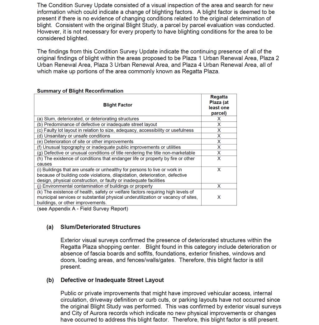
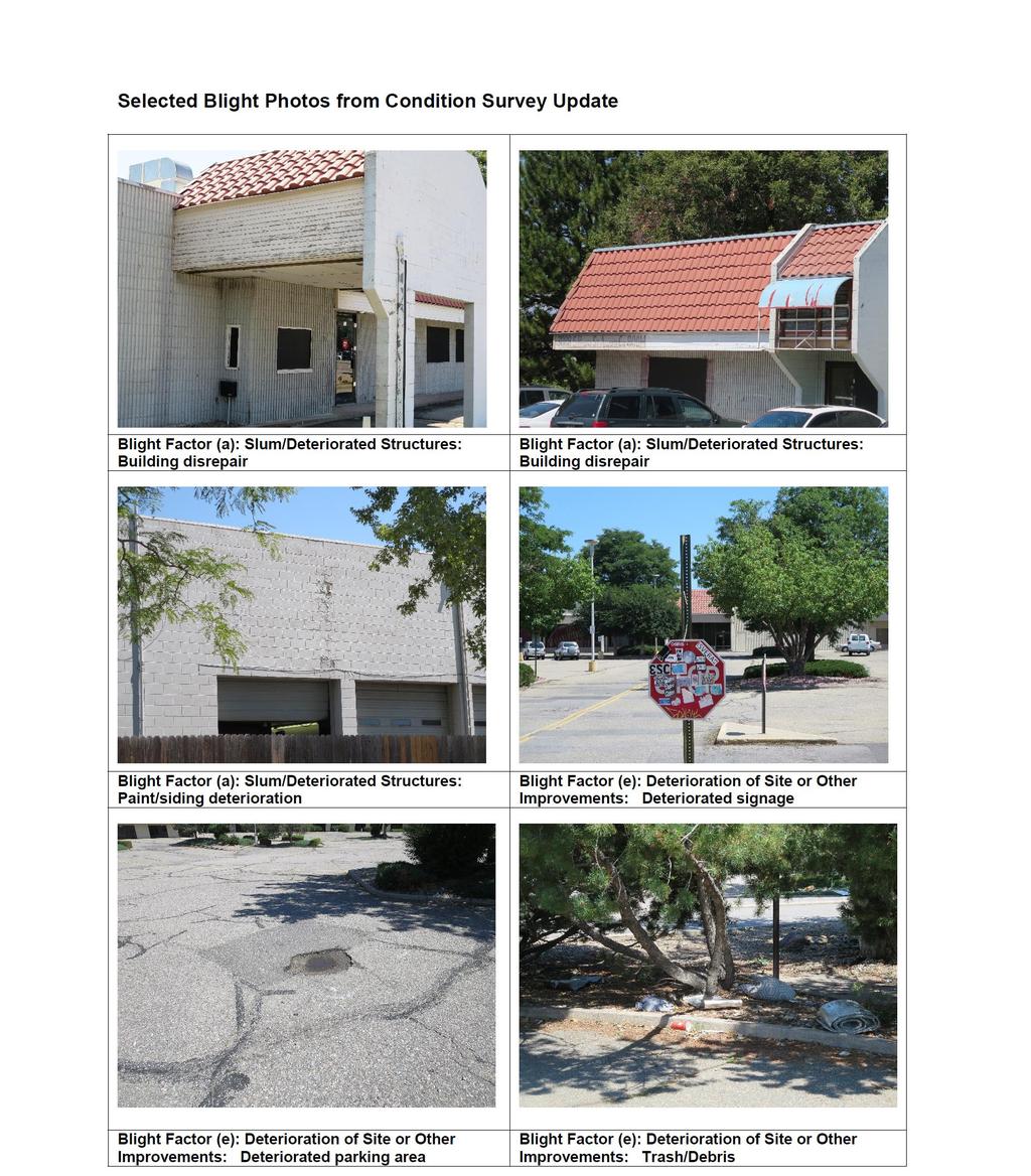
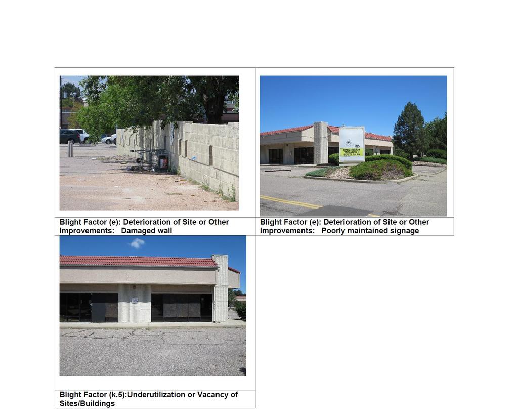
13 integrate the community with public transportation, and the park and trail amenities south of Parker Road. The redevelopment of the property within the Urban Renewal Area will be accomplished through the construction of new infrastructure and development, the attraction of new investment and reinvestment, and the elimination of slum and blight in the area. The effort will involve the Authority and City Council with participation and cooperation by the private sector. Section 4.0 Blight Conditions 4.1 Blight Findings (June 2013) Under section (2) C.R.S. (the Act ), an Urban Renewal Plan can be adopted only after the City declares an area blighted after a public hearing. The Act requires that at least four specific blight factors (and at least five specific blight factors if private property is to be acquired by the Authority by eminent domain), of 11 possible qualifying conditions (listed below), must be present to make an area appropriate and eligible for urban renewal, and must substantially impair or arrest the sound growth of the municipality, retard the provision of housing accommodations, or constitute an economic or social liability, and be a menace to the public health, safety, morals, or welfare. The Nine Mile Station Conditions Survey (or Blight Study ), dated June 2013 and prepared by Ricker-Cunningham, demonstrates that the Survey Area is a blighted area under the Act. The Blight Study is available for review as separate document. While blighting factors exist at varying levels of severity among the majority of the properties within the Survey Area (see Figure 3), it is not necessary for every property to have blighting conditions in order to declare an area blighted. In the Survey Area, the Blight Study found that all eleven (11) possible blight factors are present. Conditions of blight identified within the Nine Mile Station Blight Study Area are: 13
14 (a) Slum, deteriorated, or deteriorating structures; (b) Predominance of defective or inadequate street layout; (c) Faulty lot layout in relation to size, adequacy, accessibility, or usefulness; (d) Unsanitary or unsafe conditions; (e) Deterioration of site or other improvements; (f) Unusual topography or inadequate public improvements or utilities; (g) Defective or unusual conditions of title rendering the title nonmarketable; (h) The existence of conditions that endanger life or property by fire or other causes; (i) Buildings that are unsafe or unhealthy for persons to live or work in because of building code violations, dilapidation, deterioration, defective design, physical construction, or faulty or inadequate facilities; (j) Environmental contamination of buildings or property; (k) The existence of health, safety, or welfare factors requiring high levels of municipal services or substantial physical underutilization or vacancy of sites, buildings, or other improvements. This Plan will remedy the blight conditions identified in the Blight Study and public investment will be prioritized over time by the city and the Authority. 14
 In October 2015, a Condition Survey Update was completed for all the properties within the Regatta Plaza site, which includes")
15 Figure 3. Blight Factor Findings 4.2 Blight Confirmation (October 2015) In October 2015, a Condition Survey Update was completed for all the properties within the Regatta Plaza site, which includes the Urban Renewal Area (see Exhibit C). The survey included a parcel by parcel evaluation of blight conditions as evaluated in the 15
16 original Blight Study. The Condition Survey Update confirmed the continuing presence of all of the original findings of blight within the Urban Renewal Area. 16
17 Section 5.0 Plan s Relationship to Local Objectives and Appropriate Land Uses The implementation of this Urban Renewal Plan supports the objectives and requirements of the Comprehensive Plan, as well as the Station Area Plan, with respect to the redevelopment of the Urban Renewal Area. As development occurs in the Urban Renewal Area, it shall conform to all applicable City plans, ordinances, regulations, and policies Relationship to Aurora Comprehensive Plan The Comprehensive Plan anticipates the use of urban renewal as a means of financing infrastructure and other public improvements for elimination of blight. The purposes of this Urban Renewal Plan will be achieved more successfully if, as a part of the redevelopment, the goals of the Comprehensive Plan are met. The Authority, with the cooperation of the City, private enterprise and/or other public entities, will therefore undertake activities described in this Urban Renewal Plan to eliminate the conditions of blight while implementing the goals and objectives of the Comprehensive Plan. Redevelopment within the Urban Renewal Area will support the following themes and strategic areas articulated in the Comprehensive Plan: Managing the Geography of Growth. Chapter IV, Section A of the Comprehensive Plan envisions that the city s future growth will: create distinct parts of the city that are composed of neighborhoods, places of employment, activity centers, parks, and natural spaces; have infill and redevelopment projects that contribute to neighborhood livability; include intensely developed and walkable activity centers of differing sizes scattered throughout the city and its neighborhoods; and provide residents with opportunities for a wider range of housing choices at locations remote or proximate to places of employment. This Urban Renewal Plan supports the City s growth goals by channeling increased population and employment densities into the station area and placing more potential riders within walking distance of transit. Integrated retail, office, 17
18 residential, and public spaces in the Urban Renewal Area promote concentrations of public activity around the transit station, increasing the physical and cultural prominence of transit in the community and aiding in the long-term success and viability of the TOD. Promoting the Quality of Life in the City: Chapter IV, Section B of the Comprehensive Plan focuses on ensuring that the City of Aurora is: known for its high quality of life; is a magnet both for residents and visitors because of its shopping, restaurants... open spaces... and other cultural amenities ; is a leader in smart growth and urban renewal; and that the city has attractive visual corridors, streetscapes... [and] neighborhoods. This Urban Renewal Plan reinforces the adopted Station Area Plan which calls for a mix of office, residential and retail development near the light rail station. A new pedestrian bridge across Parker Road to enhance pedestrian safety and connectivity between the Urban Renewal Area and light rail station will contribute to the quality of development in the area. Retail within the area will be supported by new residential development, the surrounding neighborhoods, and street and rail commuters. Carrying Out an Enhanced Retail Strategy. Chapter IV, Section F of the Comprehensive Plan identifies a vision of older commercial corridors... [which] will have diversified and matured into mixed-use corridors with key commercial nodes acting as magnets for people. This theme also recognizes that the elimination of some retail locations and their replacement with office uses, high-quality multi-family residential units or mixed-use may be desirable and that under-utilized retail buildings and sites... will require zoning that allows mixed-use development with residential components and with higher densities, or other actions that encourage redevelopment. 18
19 This Urban Renewal Plan will support existing retailers and improve the retail mix by helping to increase the customer base and improve the connectivity between the existing retail properties. Creating Aurora s Future Transportation System. Chapter IV, Section H of the Comprehensive Plan envisions an integrated and efficient transportation system that includes multiple travel options [that] will link Aurora to the region, nation, and world. In support of this vision, the plan calls for jobs and housing to be located in close proximity to each other and for vibrant and mixed-use areas, attractive to residents, employees, and visitors to be developed around transit stations. Additionally, the plan states that infrastructure improvements will facilitate and enhance mobility and accessibility for pedestrians and bicyclists. This Urban Renewal Plan recognizes the strategic importance of the I-225 Light Rail Corridor and the connections it provides to the Denver Tech Center/south metro employment cluster, the medical and science uses on the Anschutz Medical Campus, and the East Line transit service to Denver International Airport and Downtown Denver. Easy transit access to these important destinations makes the Urban Renewal Area an attractive location for housing, employment, service, and retail uses. Design standards and development requirements provide for multimodal access to the station and for pedestrian and bicycle amenities. Living in Neighborhoods. Chapter IV, Section I of the Comprehensive Plan describes Types of Neighborhoods that include, new, mixed-use neighborhoods in the redeveloped portions of the inner city in proximity to defined urban centers and rail transit stations. In addition, this theme calls for high-quality housing in urban, mixed-use redevelopments with walkable, pedestrian-oriented streets including a mix of uses and the creation of community places and easily accessible amenities. 19
20 This Urban Renewal Plan supports redevelopment of Regatta Plaza as dense residential and mixed-use development with strong pedestrian and bike connections within the Urban Renewal Area and to the adjacent light rail station, Cherry Creek State Park and trails. This Plan also aims to support the incremental reorientation of businesses along Dartmouth Avenue to create a main street that flows into a redeveloped Regatta Plaza, and strengthen its connection to the light rail station, park and trails. This Plan requires quality design and integrated retail to serve both commuters and residents and which will strengthen the neighborhood. Building Urban Activity Centers. Chapter IV, Section K of the Comprehensive Plan describes centers and corridors that are increasingly linked by mass transit providing bus and rail options and stations which are accessible, as well as centers featuring key public spaces, such as parks and plazas, within an overall setting of densities higher than surrounding areas. In addition, Section K of the Comprehensive Plan addresses the significance of the City s centers and corridors being integrated into the regional transportation and roadway system. This Urban Renewal Plan reinforces and enhances the existing urban activity center at I-225 and Parker Road. The Regatta Plaza area has the most need for redevelopment and has the greatest potential to create a denser and distinctive district within the Urban Renewal Area. Regatta Plaza, with its size and proposed siting for a pedestrian bridge, creates the best opportunity to introduce a denser and distinct district integrating businesses and residents with the convenience of the light rail station. Redevelopment for Renewal. Chapter IV, Section L of the Comprehensive Plan speaks of attracting private investment for high-quality, mixed-use, pedestrianfriendly projects in aging and blighted sections of the City. This Urban Renewal Plan seeks to address blight factors present within the Urban Renewal Area and provide opportunities for new infrastructure, 20
21 commercial and residential development through incremental revenues generated by redevelopment (see Section 6.0). I-225 Strategic Area. Chapter V, Section E of the Comprehensive Plan identifies the I-225 Corridor as one of the strategic areas critical to the City s economy and identity. The vision for the I-225 Corridor states that when the City s goals are achieved: Aurora s main artery [will] pulse with activity. The corridor s attractive appearance, distinctive gateways and dynamic activity centers around TOD passenger rail stations [will] invite users and visitors to access world-class facilities along the route; A variety of housing products and prices [will be] available in the corridor, with high densities near light rail transit stops. This Urban Renewal Plan will help reinforce the I-225 strategic area vision by supporting new investment in higher density housing and complimentary commercial and retail uses at this southern transit gateway to the community. Parker Road Corridor. Chapter V, Section G of the Comprehensive Plan identifies the Parker Road Corridor as one of the strategic areas with the City. At its heart is the confluence of Parker Road, I-225, the light rail station and Peoria Street. The vision for this corridor includes seeing Regatta Plaza as a major, highdensity, mixed-use center; improved and safer pedestrian and bicycle connections to Cherry Creek State Park and the Nine Mile light rail station; and safer pedestrian crossing over Parker Road which incorporates a pedestrian bridge from Nine Mile Station to Regatta Plaza Relationship to Nine Mile Station Area Plan This Urban Renewal Plan incorporates the principles and standards of the Nine Mile Station Area Plan in its entirety as it relates to the Urban Renewal Area. The Station Area Plan establishes a long-term vision for the station area and provides a framework 21
22 for Transit-Oriented Development specific to the Nine Mile Station area. The Nine Mile Station Area Plan s Fundamental Concept Diagram (Figure 4) and the Regatta Plaza Framework Diagram (Figure 5), by their incorporation here, represent the mixed use, commercial/retail, office, housing and transit related land use elements of the Urban Renewal Plan. Unless otherwise specified in this Urban Renewal Plan, the Station Area Plan defines the land use plan and the minimum design standards and development requirements for development within the Urban Renewal Area. 5.2 Land Use: Fundamental Concept Diagram and Principles Land Use Concept Given the significant public infrastructure investments in highway widening and the I- 225 Light Rail Corridor, there is a unique opportunity to create a precedent-setting TOD program for Aurora. To this end, the Authority is interested in fostering the development of a great district or urban village characterized by compact residential development and a mix of retail and office uses in a pedestrian friendly environment, concentrated around the transit station, increasing the physical and cultural prominence of transit in the community and aiding in the long-term success and viability of the TOD. In contrast to conventional, suburban-style development which may include commercial strips, piecemeal development of retail pad sites, and low density multifamily complexes, the City is seeking to foster the growth of a high-density residential and employment district that will enable more people to live and work within an easy walking distance of the transit station. Recognizing the real challenges and complexities of undertaking dense, mixed use development, the Authority is prepared to provide financing assistance for public improvements. Over time, commercial areas are envisioned to redevelop based on the following TOD principles, described more fully in the Station Area Plan and which guided the development of the Fundamental Concept Diagram, development requirements and design guidelines: 1. TOD works as a coherent district. 22
23 2. TODs must be walkable. 3. TODs connect to the surrounding neighborhoods and make for an attractive and convenient pedestrian experience. 4. TODs are dense and provide a diversity of land uses. 5. TODs require quality design and central spaces, such as plazas and main streets, to create strong station area identity. 6. TODs promote sustainability and efficiency in infrastructure. 23

24 Figure 4. Fundamental Concept Diagram 24
25 5.2.2 Land Use Principles The Fundamental Concept Diagram provides a visual summary of the following development concepts and elements: Mixed-Use Buildings with Active Edges. Mixed-use is appropriate and desirable for all the areas indicated in the diagram; however frontages on Parker Road and Peoria Street generally are more suitable for commercial uses. The desired building form has active ground floor uses, particularly on the Dartmouth Avenue main street, along with concealed on-site parking. The high visibility corners at Parker Road and I-225, and Parker Road and Peoria Street, can have taller buildings to capitalize on their prominent locations. Transit-Supportive Housing. Residential uses are desirable within all the mixed-use areas, but this Plan particularly encourages new residential development on the east side of Peoria Street. Buildings should have elevators and be a minimum of three stories with at least forty percent four stories or higher. Buildings should have active first floor uses in appropriate locations. Having residential uses within an easy walk of the station is a paramount goal for this plan. Central Public Space and Main Streets. A central plaza or park space in the Regatta Plaza area is an important amenity, not only for any residential uses, but also to provide retail visitors and office workers a passive recreational area and a place to eat lunch outdoors. It is important that the ground floor uses near this central space be active uses, such as restaurants, retail uses, etc. Retail uses in small kiosks could also be located on the plaza or park, depending on its size. The public space and the extension of Dartmouth Avenue east of Peoria Street are seen as the major pedestrian spine and amenity in the area, and should be designed with wide and well landscaped sidewalks. 25
26 Effective, Pedestrian-Oriented Street Patterns. The street pattern is proposed to remain intact with additional roads within the Regatta Plaza area. Dartmouth Avenue is envisioned as the connecting street which could be converted into a pedestrian-oriented retail street on both sides of Peoria. Its existing width and its views to the mountains make it potentially a very attractive street. It can become a signature street for the area, with redevelopment focused on a pedestrianoriented streetscape and ground floor uses such as restaurants and cafes extending onto the sidewalks. Walkability is a key design consideration for the Nine Mile Station area with wider sidewalks and street trees on the internal streets as well as on the major arterial streets. For a pedestrian-oriented environment, roadways should be as narrow as possible and rights-of-way designed with pedestrian and cyclists needs having priority along with automobile traffic. Bicycle use is also a necessary and visible component, with bike usage incorporated either through sharrows or bike lanes. A system of bike connections will extend from the Nine Mile Station into the surrounding neighborhoods and Cherry Creek State Park. The Cherry Creek trail and other nearby trail connections south of Parker Road will be more accessible once a bridge to the light rail station is constructed. The internal street grid and the pedestrian character created by the ground floor retail fronting Dartmouth Street will contribute to creating a main street and a sense of identity for the area. The street grid layout for the Regatta Plaza area also provides the structure for development phasing (Figure 5). The commercial hub focused on Dartmouth west of Peoria and at the Regatta Plaza site will: activate the area with ground floor retail; provide for a transition to higher density development that can happen incrementally; and be supported by the drive-by visibility from Peoria and Parker Road due to the through-block, or 26
27 double-frontage lots that front these two streets. Pedestrian Circulation and Bridge. The pedestrian environment surrounding the Nine Mile Station is currently dominated by high volume, high speed roadways and highways. While these facilities serve an important mobility function for motorists traveling on I-225 and on Parker Road, they create barriers that are difficult and very dangerous for pedestrians to overcome. With new development to higher density residential and commercial uses, the potential for walking trips, particularly to and from the light rail platform, will be increased. In addition to signal timing adjustments to increase pedestrian safety, the primary pedestrian improvement in the station area will be a pedestrian and bicycle bridge across Parker Road (Figure 5). The preferred location for the bridge is aligned perpendicular to Parker Road and connects the second level of the RTD parking facility with an elevator and stair tower on the north side of Parker Road. Alternative options include integrating the bridge into new development within Regatta Plaza and/or aligning the bridge at an angle across Parker Road. In order to facilitate bicycle use of the bridge, the use of ramps or elevators in addition to or in lieu of stairs should be considered in the design of the bridge. The bridge should be enclosed, of sufficient width for pedestrians and cyclists, and be designed as a signature structure enhancing neighborhood identification and character. As part of the implementation of this Plan, the City and the Authority will work with the property owners and developers in the area to determine the best bridge funding strategy. This Plan also supports further evaluation of options to improve the pedestrian connection from the office developments east of I-225 to the Urban Renewal Area and light rail station. Although not part of the Urban Renewal Area, this office area is part of the Station Area Plan and is recognized as an important element of 27
28 the overall station area. Improved connectivity with the office area will strengthen the attractiveness of the commercial and residential developments within the Plan Area. 5.3 Catalytic Property and Other Areas A key concept associated with implementation of the Plan is targeted investment that will serve to stimulate investment throughout the Area and fund future public improvements. Certain catalytic properties have the potential to define the TOD character of the Urban Renewal Area and will have the greatest impact on surrounding developments. The key catalytic property for the Plan is Regatta Plaza Regatta Plaza The Regatta Plaza Core (Figure 5) was previously found and reconfirmed to have all eleven (11) blight factors and contains the key, catalytic properties of the Station Area Plan, collectively known as Regatta Plaza. Redevelopment of the center is complicated by several conditions, including: the center has multiple parcels under separate ownership, including King Soopers and Key Bank each wishing to remain at this location following redevelopment; existing development agreements require cooperation for reconfiguration of the center; King Soopers fuel station occupies a desirable location within the center, precluding higher density development adjacent to the light rail station without its relocation. The area is envisioned as a mix of higher density residential, retail and other commercial uses that create an urban core around the light rail station. 28

29 Figure 5. Regatta Plaza Core Key redevelopment elements of Regatta Plaza include: Mixed Uses and Structures: Residential development must be incorporated into future redevelopment and include the following considerations: High quality residential uses, with urban characteristics, must be at least three to four stories or more in height. 29
30 Residential building heights may be lower when adjacent to the property line with the Dam East neighborhood. Residential structures should incorporate elevators to appeal to a wider diversity of occupants. Residential units above commercial uses are strongly encouraged along the Main Street. Multi-tenant structures, incorporating a mix of uses and tenants shall be the primary characteristic of the redevelopment. Taller structures with office uses should be developed along I-225. Single use buildings will be limited. Main Street: Dartmouth Avenue shall be developed as an active main street and include the following considerations: Ground floor retail uses will be oriented towards the main street frontage. Both pedestrian and vehicular traffic should be accommodated to provide access and visibility to retail store fronts. Streetscaping should be attractive and with sidewalks of appropriate width and scale to encourage pedestrian activity and open air patios for restaurants and cafes. Park/Plaza: At least one small plaza or park will be incorporated into the redevelopment plan and include the following considerations: The park or plaza is located at approximately the center of the new development. Retail uses should surround this public space, but the height of buildings on the south and east sides of the park should be set back so that the park is not in shadow, if possible. King Soopers/Grocery Store: A grocery store is an important part of the redevelopment plan as it will support both existing residential needs and future 30
31 residents on the site. Incorporating a grocery store should include the following considerations: King Soopers, already an important community asset, should be accommodated to allow for a larger store up to 80,000 square feet. Maximizing the development potential of the site and accommodating the larger grocery store may require relocating King Soopers to an alternative location and orientation, possibly along Cornell Avenue. King Soopers associated fuel station should be relocated to a less prominent location with the redevelopment, ideally along Cornell Avenue and Peoria Street. Fuel station access would be improved and would also allow denser, more attractive and inviting structures at this highly visible location along Parker Road. Parking: Parking must be carefully incorporated in the redevelopment plans for Regatta Plaza and include the following considerations: A commuter parking structure could be sited north of Parker Road or west of Peoria Street and south of Parker Road. A pedestrian bridge could connect any new parking structure with the RTD parking structure and to the light rail station. Any large parking structure should be wrapped with residential, office and/or retail uses on four sides. Retail and/or office uses could be located on top of the parking structure. To keep views to the mountains, the footprints of any building should be fairly compact (at approximately 20,000 square feet). Density/Layout: Higher buildings are located near the intersection of Peoria Street and Parker Road. These uses could include both residential and office, depending on market demand. Signature Buildings and Bridge: 31
32 A signature building, either commercial, residential or both, should be located at the east terminus of Dartmouth Avenue. At the corner of I-225 and Parker Road, one or more tall buildings could be located as a signature building on I-225. These will serve as a buffer between I-225 and the rest of the redevelopment. A well, designed pedestrian bridge must be incorporated into the redevelopment plan. Following the creation of the urban renewal area, the City could use Tax Increment Financing to facilitate redevelopment of Regatta Plaza which will require ongoing discussions and analysis with all property owners to develop a feasible plan. The center is currently zoned B-3 (Business) which is incompatible with the mixed-use and residential elements of the Urban Renewal Area Land Use Concept. Rezoning to the Transit-Oriented Development Zoning District should be pursued by the owners or City. Any new uses should contribute to furthering the goals and objectives of the Plaza 4 Urban Renewal Plan Area West of Peoria Street Development concepts for other properties around the Urban Renewal Area: The smaller parcels west of Peoria Street along Dartmouth and Parker Road will transition slowly from the existing one story buildings to two stories or taller. Modified setback requirements would assist to reorient new development frontage onto Dartmouth while still maintaining excellent visibility on Parker Road. The Parker Landing shopping area could redevelop with higher density buildings that front onto Dartmouth Avenue. The existing office building along Cornell Avenue could continue the existing office uses, or redevelop to residential at a height of no more than four stories so as not to be out of scale with the existing residential area north of Cornell. 32
33 5.4 Rezoning The land within the Plaza 4 Urban Renewal Area is currently zoned with a variety of conventional zoning districts which do not permit the range, intensity and height of uses envisioned by this Plan and the Station Area Plan. The development potential of the area, especially Regatta Plaza, and Plan implementation will benefit most from TOD zoning. The City anticipates that TOD zoning will be applied at the request of property owners, however, the City will work proactively to rezone catalytic properties to protect and implement the Plan. 5.5 Design Standards All development in the Area shall conform to the laws, rules, regulations, policies and other requirements and standards of the City and any other governmental entity which has jurisdiction over all or any portion of the Area. Furthermore, this Plan reinforces the design standards and development requirements presented within the Station Area Plan. In conformance with the Act and the Plan, the Authority may also adopt additional design standards and other requirements applicable to activities undertaken by the Authority. Unless otherwise approved by the City Council, any such standards and requirements adopted by the Authority shall be consistent with all other City zoning and development policies and regulations. The following design standards are for all developments within the Urban Renewal Area. Future developments are required to meet the intent of the high quality district described in the Station Area Plan, including the use of urban methodologies for building form, density and context. Block Size and Street Grid. Blocks shall typically be no longer than 500 feet in length and no more than 1600 feet around the perimeter. Residential Density. The residential density may vary across the Urban Renewal Area depending on the zoning sub-district identified in the Station Area Plan. Overall, the plan envisions a dense urban neighborhood throughout the area. For 33
34 Regatta Plaza, the minimum residential density is 35 dwelling units per acre and the residential development must be of an urban format with design including elevators and alternatives to surface parking. The Regatta Plaza is expected to be the area with the most intensive development. Building Heights. Building heights are to be maximized (no height limit) where possible in the area, except for the maximum heights identified in the Station Area Plan. For the areas that are adjacent to or across from existing single family and townhouse residential neighborhoods, the building heights that front or back directly on these areas should transition in height. Upper story setbacks in specific locations are identified in the Station Area Plan. Building Setbacks. A continuous and consistent streetscape is desired and buildings shall generally be developed to the property line, forming a consistent and uniform street frontage. Setbacks of not more than twenty (20) feet are permitted for developments in the core and general sub-districts of the Station Area Plan to allow for provision of outdoor cafes, overhanging balconies and front yards for residential buildings. Urban Form. Building forms should be related to the width and activity on the street that they front, so that a sense of enclosure is created. A continuous building façade along all streets shall provide a defined urban edge to the street. o o o o Continuous building frontage is required on Dartmouth Avenue and Cornell Avenue with building façades occupying a minimum of eighty (80) percent of the property s street-facing frontage. Clear windows at grade are required for a minimum of sixty (60) percent of the façade length except for residential uses and grocery stores. Entries shall front on the major streets and shall be generously proportioned and defined with architectural features. Awnings and structural canopies for weather protection at building entrances are desirable. Feature buildings shall be located at prominent locations in the area as a terminus to views, particularly on Dartmouth Avenue, the intersection of 34
35 Dartmouth Avenue and Peoria Street, and at the intersection of Peoria Street and Parker Road. o o Storefront entry thresholds shall be at the adjacent sidewalk level and storefronts shall be scaled and detailed to break down large façades of buildings into small units. A variety of small scale storefront designs shall predominate over a uniform series of longer storefronts. Drive-through windows of any kind shall not be permitted except where permitted in the City s Transit-Oriented Development (TOD) District zoning code and the Station Area Plan. Pedestrian Realm. Walkways, bridges and pedestrian crossings shall constitute a network that interconnects all transit, commercial and residential buildings. Open, visible gathering places and unobstructed paths with clear visual connection to destinations are favored. In areas that will be frequented by pedestrians, ground floor uses shall consist of active commercial uses, restaurants, and entertainment venues. The active spaces shall be organized in relation to a logical pedestrian flow, without isolating retail activities from public spaces and streets. Loading docks and entrances shall not be located on major pedestrian streets. Landscape and Streetscape. Landscape and streetscape shall be urban in character, allowing for pedestrian traffic and seating, and for visual relief from the urban environment. Streetscape and open space areas should add a distinctive identity to the Urban Renewal Area, using planting, paving, lighting, signage and street furnishings as cohesive elements that reflect the building design and architectural style. The landscaped treatment on each development parcel shall be coordinated with the public space streetscape design. Landscape Materials. Materials should be provided based on the following considerations: o o Safety avoid visual obstructions, especially at circulation intersections; Local microclimate provide summer shade and open canopies for warmth in winter; 35
36 o o o Low watering requirements for the majority of plant materials and trees; Attractiveness intensity in key locations with seasonal color, texture, scale; and Screening screen service areas, parking lots, meters and garbage dumpsters. Roof Landscaping. Alternative uses for building roofs such as terraces, roof gardens, amenity decks, patios, or green roofs, should be implemented where possible. Sustainability. Sustainability should be encouraged by promoting the use of the well- established Leadership in Energy and Environmental Design (LEED) rating system. Solar Orientation, Shading and Solar Access. Building façades shall be environmentally responsible by adapting fenestration, shading and materials individually to respond to the environmental conditions of each façade s orientation. Parking: Parking within the Urban Renewal Area will be subject to the detailed requirements of the City s Transit-Oriented Development (TOD) District zoning code and its provisions for shared parking, on-street parking, bicycle parking, and parking structure design. Architecture: Architectural design should distinguish the Nine Mile Station area from other development areas in Aurora by providing distinctive detail, particularly with respect to building size and relationship to public spaces. Long building profiles shall be broken up with relief in the façades and rooflines to minimize apparent bulk and mass. In addition, 360 degree architecture will be required, with no unimproved building faces being visible from public rights-of-way. Materials and Finishes. Materials, finishes and detailing shall enrich the station area s visual and tactile qualities. Regionally-appropriate and compatible materials shall be used, carefully detailed, and combined. The building materials shall establish a consistent and high level of quality that is durable and appropriate to pedestrian contact at the street level. Materials used shall convey a high level of visual amenity that is commensurate with the urban character of the station area. Quality materials on the ground floor façade are required on all buildings on major 36
37 streets. Except for grocery stores, eighty-five (85) percent of a building façade, excluding doors and windows, facing a public park or plaza must be brick, stone or cultured stone. Section 6.0 Authorized Urban Renewal Undertakings and Activities The Act allows for a wide range of activities to be used in the implementation of an urban renewal plan. In the case of this Plan, it is the Authority s intent to undertake urban renewal activities to stimulate private investment in cooperation with property owners, developers, stakeholders and other affected parties in order to accomplish its objectives. Public-private partnerships and other forms of cooperative development will be key to the Authority s strategy for eliminating existing blight conditions and preventing the spread and reoccurrence of blight within the Urban Renewal Area. Through urban renewal activities, this Plan can potentially address all eleven (11) qualifying conditions of blight under the Act within the Area as described in Section 4.1 and in the Blight Study. 6.1 Public Improvements and Facilities The Authority may undertake certain actions to make the Area more attractive for private investment. The Authority may, or may cause others to, install, construct, and reconstruct any public improvements. The Authority may, or may cause others to, demolish and clear buildings and existing improvements for the purpose of promoting the objectives of the Plan and the Act. Additionally, the Authority may, or may cause others to, install, construct and reconstruct any other authorized improvements, including, without limitation, other authorized undertakings or improvements for the purpose of promoting the objectives of this Plan and the Act. Public undertakings are intended to stimulate (directly and indirectly) private sector investment to assist in the conversion of the Area into a viable commercial, employment and mixed-use district supported by accessible transportation with attractive public spaces, which contribute to increased revenues from property and City taxes. 37
38 6.1.1 Pedestrian Bridge The Authority, in conjunction with the City, RTD, and any appropriate property owners, will work to fund the design and construction of a pedestrian bridge as conceived within the Station Area Plan. The City and Authority will also seek to partially fund the bridge through grants. The Authority may exercise it powers under the Act as reference in Section 6.6 of this Plan, to acquire property to accommodate the bridge and its ancillary structures. 6.2 Other Improvements and Facilities Other non-public improvements or facilities in the Area may be required in connection with urban renewal activities and undertakings to accommodate development of the Area. These may include items such as enhanced building façades and upgraded lighting, landscaping, benches and other amenities. The Authority may assist in the financing or construction of these improvements insofar as such improvements and activities serve a public purpose and further the goals and objectives of this Plan. 6.3 Brownfields The Authority may also nominate sites for assessment under the United States Environmental Protection Agency s Targeted Brownfields Assessment Program. The Authority, in conjunction with the City, can direct Revolving Loan Funds to help fund remediation and use TIF to offset redevelopment costs. Other loan and grant program funds may be directed to the Area as appropriate. 6.4 Development Opportunities Catalyst Activities A key concept associated with implementation of the Plan is targeted investment that will serve to catalyze development throughout the Area and fund needed public improvements. The Regatta Plaza properties (see Exhibit C) are the largest and most significant catalyst opportunity. This site should be rezoned as prescribed in the Station 38
39 Area Plan and redeveloped with the mixed-use and pedestrian-oriented character of a TOD. 6.5 Development Standards In conformance with the Act and the Plan, the Authority may adopt design standards and other requirements applicable to activities undertaken by the Authority. It is the intent of the City Council in adopting this Plan to conform to all concepts, land uses and design standards of this Plan. Unless otherwise approved by the City Council, any such standards and requirements adopted by the Authority shall be consistent with all other City zoning and development policies and regulations. 6.6 Variations in Plan Over time, the Authority may propose and the City Council may make such modifications to this Urban Renewal Plan as may be necessary provided they are consistent with the Comprehensive Plan and any subsequent updates, as well as the Act. The Authority may in specific cases allow non-substantive variations from the provisions of this Plan if it determines that a literal enforcement of the provisions of this Plan would constitute an unreasonable limitation beyond the intent and purpose of this Plan. If any portion of this Urban Renewal Plan is held to be invalid or unenforceable, such invalidity will not affect the remaining portions of the Plan. 6.7 Financing of Undertakings and Activities and Creation of Tax Increment Areas The Authority may finance undertakings pursuant to this Plan by any method authorized under the Act or any other applicable law, including without limitation, utilization of the following: issuance of notes, bonds and other obligations in an amount sufficient to finance all or part of this Plan; borrowing of funds and creation of indebtedness; loans, advances, and reimbursement agreements; appropriations, loans, grants or advances from the City; federal, state or other loans or grants; interest income; agreements with public or private entities, including any arrangements made for the payment of moneys in lieu of taxes; sale of property or other assets; and pledging of 39
40 lawfully available revenues to one or more special districts or other governmental or quasi-governmental entities to be used and pledged by such entities to pay their obligations incurred to finance public infrastructure and other lawful improvements under the Act. For purposes of this Plan, Debt may include bonds, refunding bonds, notes, interim certificates or receipts, temporary bonds, certificates of indebtedness, advance and reimbursement agreements, Public Finance and Redevelopment Agreement(s), or any other obligation lawfully created by the Authority, any special district or other governmental or quasi-governmental entity. In addition to the above referenced financing methods, an accepted method for financing urban renewal undertakings and activities is to utilize incremental tax revenues, including property and/or municipal excise tax revenues (including sales, lodgers, use and occupational privilege tax revenues) attributable to the redevelopment in the Plan area to pay the principal of, the interest on, and any premiums due in connection with the bonds, or loans or advances to, or indebtedness incurred by the Authority. It is the intent of the City Council in approving this Urban Renewal Plan to authorize the use of Tax Increment Financing by the Authority as part of its efforts to assist in the redevelopment of the Area. Pursuant to the provisions of Section (9) of the Act and Section of the City Code, the City Council, in approving this Plan, creates a Tax Increment Area contiguous with the Urban Renewal Area. Subject to the TIF Area Effective Date of Allocation, the Authority is specifically authorized to use incremental revenues, except those previously dedicated, for the benefit of the Area, to the extent authorized by the provisions of Section (9) of the Act and Section of the City Code, as the same may be amended from time to time, which sections are incorporated herein by reference in their entirety. The Plan authorizes the Authority to use or allocate all or a portion of such incremental tax revenues to finance the costs of urban renewal undertakings and activities through the provisions of one or more public finance and redevelopment agreements, including, 40
41 to the extent determined by the Authority, pledging all or part of said revenues to a special district or other government or quasi-governmental entity created for the purpose of financing public infrastructure and other lawful improvements for the benefit of a redevelopment, and to be pledged by such district or entity for payments on obligations it incurs to fund such infrastructure or improvements or, at the option of the Authority, to be used as security for debt or other obligations of the Authority to fund public infrastructure and other lawful improvements under the Act and the City Code. Each Tax Increment Area approved by City Council shall continue in existence for a period of not to exceed twenty-five years from the TIF Area Effective Date of Allocation as specified by the Authority and detailed in this Plan Eligible Activities for TIF Consideration Redevelopment activities located within the Area will need to conform with the Act, to this Plan as well as the City s Comprehensive Plan, and the Station Area Plan in order to be considered for TIF, although the Authority may include certain properties within the Tax Increment Area to reserve revenues for other area activities or improvements Tax Increment Financing Area Pursuant to the provisions of Section (9) of the Act and Section of the City Code, the City Council, in approving this Plan, authorizes the creation of a Tax Increment Area, contiguous with the boundaries of the Urban Renewal Area. This Tax Increment Area shall be deemed established on the date of approval of this Plan. The overall boundaries and legal description for the Tax Increment Area are shown in Figure 1 and Exhibit A. The Tax Increment Area is planned to facilitate a portion of the Regatta Plaza site redevelopment, and will contain a predominantly mixed use project including an approximately 228,000 square foot office building, and associated parking and public improvements. Additional commercial and/or residential development potential also exists within the Urban Renewal Area. 41
42 Upon submittal and approval of a site plan for redevelopment within the Tax Increment Area, also known as the TIF Area Effective Date of Allocation, the boundary, legal description and TIF allocation for the Tax Increment Area shall commence. Such delineation and allocation shall not be considered an amendment to the Urban Renewal Plan under the Act. Under the terms of an approved PFRA(s) between the City of Aurora, the Authority and a third-party redeveloper of the TIF Area, the Authority intends to rebate a portion of incremental tax revenue generated within the TIF Area to offset costs associated with development, park, drainage, and other public improvements. The redevelopment plans shall be consistent with the City s Comprehensive Plan and this Urban Renewal Plan. For a period of 25 years, 100% of all incremental tax revenue generated from activities in the TIF Area shall be shared between the Authority and any private or public parties as defined in a PFRA(s) or Intergovernmental Agreement. 6.8 Property Acquisition and Land Assemblage The Authority may acquire property or any interest therein by negotiation or any other method authorized by the Act. In addition, the Authority may acquire private property or any interest therein through the exercise of the power of eminent domain, which property or interest may be transferred to a private party as the Authority deems appropriate; provided, however, that any such acquisition and/or transfer shall be conducted in accordance with Sections and (4.5) of the Act, as from time to time amended. The Authority may operate, manage and maintain such acquired property in accordance with the powers granted to it under the Act. 6.9 Relocation Assistance It is not anticipated that acquisition of real property by the Authority will result in the relocation of any individuals or families, however, business concerns could be impacted. If such relocation becomes necessary, the Authority shall act in accordance with the Relocation Assistance and Land Acquisition Policy adopted by the Authority Board on 42
43 October 18, 2004, per Authority Resolution R , or its subsequent amendment, and in conformance with the Act Demolition, Clearance, Environmental Remediation, and Site Prep In carrying out this Plan, it is anticipated that the Authority may, on a case-by-case basis, elect to demolish and clear buildings, structures and other improvements. Additionally, redevelopment activities consistent with this Plan, including but not limited to Public Finance and Redevelopment Agreements, may require such demolition and clearance to eliminate unhealthy, unsanitary, and unsafe conditions, eliminate obsolete and other uses detrimental to the public welfare, and otherwise remove and prevent the spread of deterioration. Environmental remediation, if required, may be facilitated through the use of various Federal programs that are available as a result of being located within the Area. With respect to property acquired by the Authority, it may demolish and clear, or contract to demolish and clear, those buildings, structures and other improvements pursuant to this Plan, if, in the judgment of the Authority it is the best means to forward the implementation of the Plan. The Authority may also undertake such additional site preparation and environmental remediation activities, as it deems necessary to facilitate the disposition and/or development of such property Property Disposition The Authority may sell, lease, or otherwise transfer real property or any interest in real property subject to covenants, conditions and restrictions, including architectural and design controls, time restrictions on development, and building requirements, as it deems necessary to develop such property. Real property or interests in real property may be sold, leased or otherwise transferred for uses in accordance with the Act and this Plan. 43
44 6.12 Redevelopment and Rehabilitation Actions Redevelopment and rehabilitation actions by the Authority may include such undertakings and activities as are in accordance with this Plan and the Act, including without limitation: demolition and removal of buildings and improvements as set forth herein; installation, construction and reconstruction of public improvements as set forth herein; rehabilitation of buildings and sites; elimination of unhealthy, unsanitary or unsafe conditions; elimination of obsolete or other uses detrimental to the public welfare; prevention of the spread of deterioration; and, provision of land for needed public facilities. The Authority may enter into Cooperative Agreements and Redevelopment/Development Agreements to provide assistance or undertake all other actions authorized by the Act or other applicable law to redevelop and rehabilitate the Area Public Finance and Redevelopment Agreements For the purpose of this Plan, the Authority is authorized to use or allocate all or a portion of the Tax Increment to finance the costs of urban renewal activities and undertakings necessary or desirable to carry out the purposes of this Plan through the provisions of a Public Finance and Redevelopment Agreement (PFRA), intergovernmental agreement or other lawful agreement. At the discretion of the Authority, this may include pledging all or part of said revenues to a special district or other government or quasi-governmental entity created for the purpose of financing public infrastructure and other lawful improvements for the benefit of a redevelopment, and to be pledged by such district or entity for payments on obligations it incurs to fund such infrastructure or improvements. Furthermore, the Authority may, at its discretion, pledge all or part of said revenues as security for debt or other obligations of the authority to fund public infrastructure and other improvements under the Act and the City Code. Such PFRAs, or other contracts, may contain such terms and provisions as shall be deemed necessary or appropriate by the Authority for the purpose of undertaking the activities contemplated by this Plan and the Act, and may further provide for such 44
45 undertakings by the Authority as may be necessary for the achievement of the objectives of this Plan or as may otherwise be authorized by the Act. Existing agreements between the City and private parties that are consistent with this Plan are intended to remain in full force and effect Cooperative Agreements For the purpose of this Plan, the Authority may enter into one or more Cooperative Agreements pursuant to the Act. The City and the Authority recognize the need to cooperate in the implementation of this Plan and, as such, Cooperative Agreement(s) may include, without limitation, agreements regarding the planning or implementation of this Plan and its undertakings and activities, as well as programs, public works operations, or activities which the Authority, the City or such other public body is otherwise empowered to undertake and includes, without limitation, agreements respecting the financing, installation, construction and reconstruction of public improvements, utility line relocation, storm water detention, environmental remediation, landscaping and/or other eligible improvements. The Cooperative Agreements may reference or include services that are typically provided by such Agencies, such as public education and other programs and services. This paragraph shall not be construed to require any particular form of cooperation. 45
46 EXHIBIT A: Urban Renewal Area and TIF Area Legal Description PLAZA 4 URBAN RENEWAL AREA A PARCEL OF LAND BEING A PORTION OF LOT 1, BLOCK 5, DILLON SUBDIVISION FILING NO. ONE AS RECORDED UNDER RECEPTION NO , IN THE RECORDS OF THE ARAPAHOE COUNTY CLERK AND RECORDER'S OFFICE AND A PORTION OF LOT 1, BLOCK 1, REGATTA PLAZA SUBDIVISION FILING NO.1 AS RECORDED UNDER RECEPTION NO , IN SAID RECORDS, LOCATED IN THE WEST HALF OF SECTION 36, TOWNSHIP 4 SOUTH, RANGE 67 WEST OF THE SIXTH PRINCIPAL MERIDIAN, IN THE CITY OF AURORA, COUNTY OF ARAPAHOE, STATE OF COLORADO MORE PARTICULARLY DESCRIBED AS FOLLOWS: COMMENCING AT THE WEST QUARTER CORNER OF SAID SECTION 36 AND CONSIDERING THE WEST LINE OF THE NORTHWEST QUARTER OF SAID SECTION 36 TO BEAR NORTH 00'27'00" WEST, A DISTANCE OF FEET, WITH ALL BEARINGS CONTAINED HEREIN RELATIVE THERETO; THENCE SOUTH 54'09'02" EAST, A DISTANCE OF FEET TO A POINT ON THE NORTHERLY RIGHT-OF-WAY OF SOUTH PARKER ROAD AS DESCRIBED IN WARRANTY DEED AS RECORDED UNDER RECEPTION NO. B , IN SAID RECORDS AND THE POINT OF BEGINNING. THENCE DEPARTING SAID NORTHERLY RIGHT-OF-WAY, NORTH 00'27'00" WEST, A DISTANCE OF FEET; THENCE SOUTH 89'33'00" WEST, A DISTANCE OF FEET; THENCE NORTH 00'27'00" WEST, A DISTANCE OF FEET; THENCE NORTH 89'33'00" EAST, A DISTANCE OF FEET; THENCE NORTH 00'27'00" WEST, A DISTANCE OF FEET; THENCE NORTH 89'33'00" EAST, A DISTANCE OF FEET TO A POINT ON THE EASTERLY BOUNDARY OF SAID LOT 1, BLOCK 5, DILLON SUBDIVISION FILING NO. ONE; THENCE ALONG SAID EASTERLY BOUNDARY, SOUTH 00'27'00" EAST, A DISTANCE OF FEET; THENCE CONTINUING ALONG SAID EASTERLY BOUNDARY AND THE EASTERLY BOUNDARY OF SAID LOT 1, BLOCK 1 REGATTA PLAZA SUBDIVISION FILING NO, 1, SOUTH 51'39'11" EAST, A DISTANCE OF FEET TO THE SOUTHEASTERLY BOUNDARY OF SAID LOT 1, BLOCK 1 REGATTA PLAZA SUBDIVISION FILING NO.1; 46
47 THENCE ALONG SAID SOUTHEASTERLY BOUNDARY, SOUTH 56'09'21" WEST, A DISTANCE OF FEET TO A POINT ON SAID NORTHERLY RIGHT-OF-WAY OF SOUTH PARKER ROAD; THENCE ALONG SAID NORTHERLY RIGHT-OF-WAY, SOUTH 88'38'28" WEST, A DISTANCE OF FEET TO THE POINT OF BEGINNING. CONTAINING AN AREA OF ACRES, (231,616 SQUARE FEET), MORE OR LESS. 47
48 EXHIBIT B: Nine Mile Station Area Conditions Survey (By Reference only) Prepared and approved pursuant to City Council Resolution R as separate document and available for public viewing. 48
49 EXHIBIT C: Condition Survey Update (October 2015) 49
50 50
51 51
52 52
53 53
54 54
55 55
Santa Fe Urban Renewal Plan
 Santa Fe Urban Renewal Plan City of Littleton, Colorado Santa Fe Urban Renewal Plan Table of Contents Section 1.0 Introduction 3 1.1 Preface 1.2 Blight Findings 1.3 Other Findings 1.4 Urban Renewal Plan
Syracuse General Redevelopment Plan Study Areas #1-3
 2010 Syracuse General Redevelopment Plan Study Areas #1-3 JEO Consulting Group, Inc. SYRACUSE GENERAL REDEVELOPMENT PLAN STUDY AREAS 1-3 Introduction/Background INTRODUCTION The Syracuse General Redevelopment
B-2 COMMUNITY COMMERCIAL BUSINESS DISTRICT. Uses allowed in the B-2 Community Commercial Business District are subject to the following conditions:
 SECTION 46-53.1 B-2 COMMUNITY COMMERCIAL BUSINESS DISTRICT A. PURPOSE The B-2 Community Commercial Business District is oriented toward retail, service businesses and multi-family residential development.
Tax Increment Financing
 Tax Increment Financing Colorado Department of Local Affairs Division of Property Taxation Greg Schroeder 303-866-2681 greg.schroeder@state.co.us June 29, 2010 What is Tax Increment Financing? Tax increment
IX. STRATEGIC PLAN ELEMENT
 IX. STRATEGIC PLAN ELEMENT The Strategic Plan Element provides the action and implementation plan for the New Brunswick Master Plan. New Brunswick is a fully developed, older urban area in central New
LUNDY S LANE COMMUNITY IMPROVEMENT PLAN STUDY
 PUBLIC INFORMATION MEETING # October, 0 LUNDY S LANE COMMUNITY IMPROVEMENT PLAN STUDY AGENDA :00 to :0pm: Open House :0 to :pm: Presentation : to :00pm: Individual paced workshop with the Study Team PUBLIC
Second Amendment to the Urban Renewal Plan for the Ingersoll-Grand Commercial Urban Renewal Area
 Prepared by: Carrie Kruse, Office of Economic Development, 400 Robert D. Ray Drive, Des Moines, IA 50309 Phone: 515/283-4012 Return Address: City Clerk City Hall, 400 Robert D. Ray Drive, Des Moines, IA
Vero Beach Vision Plan
 Vero Beach Vision Plan City of Vero Beach, Florida Prepared in cooperation with: The Vero Beach Vision Team and The Citizens of Vero Beach Prepared by: Gould Evans Associates 4041 Mill Street Kansas City,
LAND USE POLICIES BY COMMUNITY DESIGNATION
 137 2040 138 Land Use Policies by Community Designation As discussed earlier in Thrive MSP 2040, the Council assigns a community designation to each city and township. This designation indicates the overall
Project Plan for TAX INCREMENTAL FINANCE DISTRICT #41 (UNIVERSITY-WHITNEY) City of Madison
 City of Madison") Project Plan for TAX INCREMENTAL FINANCE DISTRICT #41 (UNIVERSITY-WHITNEY) City of Madison Prepared by: Department of Planning and Community and Economic Development Economic Development Division Office
Project Plan for TAX INCREMENTAL FINANCE DISTRICT #41 (UNIVERSITY-WHITNEY) City of Madison Prepared by: Department of Planning and Community and Economic Development Economic Development Division Office
CITY OF ASHLAND REDEVELOPMENT PLAN FOR THE ASHLAND INVESTMENT CO., LLC HOUSING DEVELOPMENT
 CITY OF ASHLAND REDEVELOPMENT PLAN FOR THE ASHLAND INVESTMENT CO., LLC HOUSING DEVELOPMENT I. INTRODUCTION. The City of Ashland, Nebraska, recognizes that blight is a threat to the continued stability
Project Plan for TAX INCREMENTAL FINANCE DISTRICT #41 (UNIVERSITY-WHITNEY) City of Madison
 City of Madison") Project Plan for TAX INCREMENTAL FINANCE DISTRICT #41 (UNIVERSITY-WHITNEY) City of Madison Prepared by: Department of Planning and Community and Economic Development Economic Development Division Office
Project Plan for TAX INCREMENTAL FINANCE DISTRICT #41 (UNIVERSITY-WHITNEY) City of Madison Prepared by: Department of Planning and Community and Economic Development Economic Development Division Office
Corridor Residential Traditional District Regulations City of St. Petersburg City Code Chapter 16, Land Development Regulations
 Section 16.20.060 - Corridor Residential Traditional Districts ( CRT ) Typical Buildings in the CRT District Sections: 16.20.060.1 Composition of Traditional Residential Corridors 16.20.060.2 Purpose and
Neighborhood Suburban Single-Family District Regulations City of St. Petersburg City Code Chapter 16, Land Development Regulations
 16.20.020 Neighborhood Suburban Single-Family District ( NS ) Figure REFRENCE Typical Houses in Neighborhood Suburban 1 Figure REFRENCE Typical Block in a Neighborhood Suburban District Sections: 16.20.020.1
PINELLAS COUNTY MOBILITY PLAN SUMMARY REPORT
 PINELLAS COUNTY MOBILITY PLAN SUMMARY REPORT In September, 2013, the Pinellas County Mobility Plan Report was approved by the Metropolitan Planning Organization (MPO). This action endorsed a countywide
Neighborhood Traditional Single-Family District Regulations City of St. Petersburg City Code Chapter 16, Land Development Regulations
 Section 16.20.010 - Neighborhood Traditional Single-Family Districts ( NT ) Typical Houses in a Neighborhood Traditional District Typical Block in a Neighborhood Traditional District Common Features of
Technical and Physical Feasibility Fact Sheet Alternative 28: Infill/Density
 Technical and Physical Feasibility Fact Sheet Alternative 28: Infill/Density Acknowledgements: This fact sheet was written by Phyllis Taylor of Sites Southwest as part of the Evaluation of Alternative
THE REGION S PLAN POLICY FRAMEWORK. August 2015
 THE REGION S PLAN POLICY FRAMEWORK August 2015 2 What is The Policy Framework? Cover photo credit: Sinan Sinharoy for Atlanta BeltLine, Inc. Atlanta is one of the world s most dynamic metropolitan areas,
Neighborhood Suburban Single-Family District Regulations City of St. Petersburg City Code Chapter 16, Land Development Regulations
 Section 16.20.020 - Neighborhood Suburban Single-Family Districts ( NS ) Sections: Typical Block in a Neighborhood Suburban District 16.20.020.1 History and Composition of Suburban Neighborhoods 16.20.020.2
Corridor Residential Traditional District Regulations City of St. Petersburg City Code Chapter 16, Land Development Regulations
 16.20.060 - Corridor Residential Traditional District ( CRT ) Figure REFERENCE Typical Buildings in the CRT District Sections: 16.20.060.1 Composition of Traditional Residential Corridors 16.20.060.2 Purpose
Transit Oriented Development Study
 Federal Way Link Extension Transit Oriented Development Study Table of Contents Executive Summary ES 1 Chapter 1: Introduction.. 1-1 Chapter 2: Methodology. 2-1 Chapter 3: Project Overview 3-1 Chapter
BOSTON REDEVELOPMENT AUTHORITY DEVELOPMENT PLAN FOR PLANNED DEVELOPMENT AREA NO. 103 SOUTH BAY DEVELOPMENT. 101 Allstate Road.
 BOSTON REDEVELOPMENT AUTHORITY DEVELOPMENT PLAN FOR PLANNED DEVELOPMENT AREA NO. 103 SOUTH BAY DEVELOPMENT 101 Allstate Road Dorchester Allstate Road (Edens), LLC [, 2016] Development Plan: In accordance
BROOMFIELD PLAZA-CIVIC CENTER URBAN RENEWAL PLAN
 August 5, 2013 City and County of Broomfield BROOMFIELD PLAZA-CIVIC CENTER URBAN RENEWAL PLAN Ordinance 1978 1.0 PREFACE 2 3.1 2013 Conditions Survey 3.0 SUMMARY OF ELIGIBILITY CRITERIA The Area in this
Notwithstanding article VII of this chapter, the following conditional uses may be permitted in the planned mixed use development (PMUD) zone:
 zone:") DIVISION 14. - PLANNED MIXED USE DEVELOPMENT (PMUD) Sec. 78-1021. - Purpose. The town is a community with a rich tradition of mixed use neighborhoods and a paucity of land area dedicated for large commercial,
DIVISION 14. - PLANNED MIXED USE DEVELOPMENT (PMUD) Sec. 78-1021. - Purpose. The town is a community with a rich tradition of mixed use neighborhoods and a paucity of land area dedicated for large commercial,
CHAPTER 6: ECONOMIC DEVELOPMENT INTRODUCTION CHAPTER 6: ECONOMIC DEVELOPMENT 6-1
 CHAPTER 6: ECONOMIC DEVELOPMENT INTRODUCTION The purpose of this chapter is to identify strategies to increase commercial and industrial development in the City of Dayton. There are currently few commercial
DR-15-11/LLA Staff Presentation for ConAM Properties LLC applications for Design Review and Lot Line Adjustment
 DR-15-11/LLA-15-01 Staff Presentation for ConAM Properties LLC applications for Design Review and Lot Line Adjustment Existing Zoning and Land Uses Enter footer information 2 Office Business Center (OBC)
URBAN CENTER COMMUNITY ROLE COUNCIL ROLE ALL COMMUNITIES URBAN CENTER
 Orderly and Efficient Land Use Align land use, development patterns, and infrastructure to make the best use of public and private investment. Plan for forecasted population and household growth at average
CHAPTER 13 R-5 MANUFACTURED MOBILE HOME PARK RESIDENTIAL DISTRICT
 15.1300 CHAPTER 13 R-5 MANUFACTURED MOBILE HOME PARK RESIDENTIAL DISTRICT 15.1301 SECTION 13.01 STATEMENT OF PURPOSE To provide for manufactured home park development, of long-term duration of stay, in
Tax Increment Finance: An Emerging Community Revitalization Tool
 Tax Increment Finance: An Emerging Community Revitalization Tool May 3, 2007 St. Louis, MO About CDFA National non-profit dedicated to the advancement of the development finance industry Founded in 1982
Zoning Permits 11-1 ZONING PERMITS
 Zoning Permits 11-1 ZONING PERMITS (a) Building or structures shall be started, repaired, reconstructed, enlarged or altered only after a zoning permit has been obtained from the administrator and a building
CHAPTER R-6,000 Single-Family Residential. 6,000 Square Foot Minimum Lots
 CHAPTER 19.25 R-6,000 Single-Family Residential 6,000 Square Foot Minimum Lots Sections: 19.25.010 PURPOSE 19.25.020 PERMITTED USES 19.25.030 USES SUBJECT TO A CONDITIONAL USE PERMIT 19.25.040 PERMITTED
ONLY ONLY BUILDING AND PARKING ENVELOPE RAMP STAIRS NEW SURFACE PARKING PROPOSED HOTEL PROPOSED TWO STORY PARKING STRUCTURE NEW SURFACE PARKING
 LOCATION MAP SITE DEVELOPMENT DATA: --ACREAGE: ± 5. ACRES -- ZONING: MUDD-O -- USES: UP TO TWO () HOTELS WITH UP TO 70 ROOMS (APPROXIMATELY 00 ROOMS IN THE EXISTING HOTEL ON THE SITE, AND UP TO 70 ROOMS
Infrastructure Financing Programs (DIF)
") Infrastructure Financing Programs (DIF) Massachusetts Municipal Association January 24, 2015 Infrastructure Needs in Massachusetts* Approximately 10% of bridges are classified as Structurally Deficient
Infrastructure Financing Programs (DIF) Massachusetts Municipal Association January 24, 2015 Infrastructure Needs in Massachusetts* Approximately 10% of bridges are classified as Structurally Deficient
Downtown Life-Safety Compliance Grant Program
 Downtown Life-Safety Compliance Grant Program Information & Grant Application Downtown Bozeman Partnership DOWNTOWN TAX INCREMENT FINANCE DISTRICT 222 East Main Street #302 Bozeman MT 59715 phone 406-586-4008
URBAN RENEWAL DISTRICT II TAX INCREMENT FINANCING CRITERIA FOR REVIEW
 URBAN RENEWAL DISTRICT II TAX INCREMENT FINANCING CRITERIA FOR REVIEW BACKGROUND INFORMATION In 1991, the Missoula City Council adopted an Urban Renewal Plan creating Urban Renewal District II. The intent
VULCAN LAKES TAX INCREMENT FINANCING REDEVELOPMENT PLAN AND PROGRAM. City of Crystal Lake, Illinois
 VULCAN LAKES TAX INCREMENT FINANCING REDEVELOPMENT PLAN AND PROGRAM City of Crystal Lake, Illinois DRAFT August 2005 TABLE OF CONTENTS INTRODUCTION 1 REDEVELOPMENT PROJECT AREA DESCRIPTION... 2 Legal Description...3
Wheaton PRELIMINARY RECOMMENDATIONS
 Wheaton PRELIMINARY RECOMMENDATIONS Wheaton Finding the right balance of land uses within the diversity unique to Wheaton Wheaton s Role in the County Wheaton + Silver Spring = full set Services employment,
# Mercyhealth Hospital Project Review for Planning and Zoning Commission
 #2017-38 Mercyhealth Hospital Project Review for Planning and Zoning Commission Meeting Dates: December 6, 2017 and January 3, 2018 Requests: 1. Preliminary Planned Unit Development and 2. Special Use
City of Kingston Engineering Department. Application for New Outdoor Patio. Note: Agreement:
 City of Kingston Engineering Department Application for New Outdoor Patio Address of area to be leased: Applicant s Name: Business Name: Business Address: Telephone Number: Contact Name: Mailing Address:
A. Applicability and Review Authority.
 5.6 Development Plans Required for Architectural and Site Design Review in the TC: Town Center District, the R-U: Urban Residential District and the MU: Mixed Use District. Intent In order to: assure the
Mall Area Redevelopment TIF District Proposal
 Mall Area Redevelopment TIF District Proposal (SDFPAB) Economic Development Committee April 7, 2014 Purpose Provide background for each redevelopment area Provide overview of proposal for new TIF district
TAX INCREMENT FINANCING Ten (10) Year Status Report
 Year Status Report") TAX INCREMENT FINANCING Ten (10) Year Status Report 2000-2011 LAKE CALUMET INDUSTRIAL Redevelopment Project Area Designated December 13, 2000 September 18, 2013 Pursuant to 65 ILCS 5/11-74.4-5 Prepared
TAX INCREMENT FINANCING Ten (10) Year Status Report 2000-2011 LAKE CALUMET INDUSTRIAL Redevelopment Project Area Designated December 13, 2000 September 18, 2013 Pursuant to 65 ILCS 5/11-74.4-5 Prepared
Addison LLC Project. Central Business District. City Council and Community Presentation December 6, 2010
 Addison LLC Project Central Business District City Council and Community Presentation December 6, 2010 CBD TIF I Original Project Area Established by Ordinance O-17-86 (With Sales Tax District) TIF I:
CITY OF OAK FOREST Community Development Department
 CITY OF OAK FOREST Community Development Department REQUEST FOR PROPOSALS TRANSIT-ORIENTED DEVELOPMENT OF THE GATEWAY RFP Issued: April 18, 2014 Submission Due: May 31, 2014 The Table of Contents I. Introduction...
r e s i d e n t i a l o u t s i d e v i l l a g e c e n t e r
 N e w A l b a n y, O h i o r e s i d e n t i a l o u t s i d e v i l l a g e c e n t e r D e s i g n G u i d e l i n e s & R e q u i r e m e n t s s e c t i o n 5 I. Overview This section applies to all
Blight After Kelo. Redevelopment and Condemnation. Kirby A. Glaze Public-Private Partnership Project Management, Inc.
 Blight After Kelo Redevelopment and Condemnation Kirby A. Glaze Public-Private Partnership Project Management, Inc. What is Kelo? What is Kelo? HIGH COURT EXPANDS REACH OF EMINENT DOMAIN FOXNEWS What is
Hollywood Theatre Redevelopment Plan September 12, 2008
 Hollywood Theatre Redevelopment Plan Prepared by the Development Finance Division 105 5 th Avenue South, Minneapolis, Minnesota 55401 Introduction and Background Redevelopment Plan I. Description of Project
TAX INCREMENT FINANCING Ten (10) Year Status Report
 Year Status Report") TAX INCREMENT FINANCING Ten (10) Year Status Report 2006-2014 63 RD /ASHLAND Redevelopment Project Area Designated March 29, 2006 December 2, 2015 Pursuant to 65 ILCS 5/11-74.4-5 Prepared by AND S. B.
TAX INCREMENT FINANCING Ten (10) Year Status Report 2006-2014 63 RD /ASHLAND Redevelopment Project Area Designated March 29, 2006 December 2, 2015 Pursuant to 65 ILCS 5/11-74.4-5 Prepared by AND S. B.
ARTICLE VII - OFF-STREET PARKING AND LOADING Section 7-10
 ARTICLE VII - OFF-STREET PARKING AND LOADING Section 7-10 Section 7-10.1 Off Street Parking. Off-street parking spaces, with proper access from a street, alley or driveway shall be provided in all districts
II. Land Use A. INTRODUCTION B. BACKGROUND
 II. Land Use A. INTRODUCTION The Land Use Element establishes a comprehensive set of explicit goals, policies and implementation actions which will guide the future use and development of land within the
Transit Service Guidelines
 G R E AT E R VA N CO U V E R T R A N S P O RTAT I O N A U T H O R I T Y Transit Service Guidelines PUBLIC SUMMARY REPORT JUNE 2004 Greater Vancouver Transportation Authority TRANSIT SERVICE GUIDELINES
The Strip: Dealing with Shopping Centers and Big Boxes
 Center for Quality Growth and Regional Development Governments & Growth Breakout Session The Strip: Dealing with Shopping Centers and Big Boxes Rob Hosack, AICP, Community Development Agency Michael Hughes,
STAFF REPORT. Project Description. Proposal. Snyderville Basin Planning Commission From:
 STAFF REPORT To: Snyderville Basin Planning Commission From: Ray Milliner, County Planner Date of Meeting: May 12, 2015 Type of Item: Public Hearing, No Action Process: Administrative Review RECOMMENDATION:
NORTHWEST TERRITORIES CONSOLIDATION OF CAPITAL AREA DEVELOPMENT SCHEME BY LAW NO. 3934
 NORTHWEST TERRITORIES CONSOLIDATION OF CAPITAL AREA DEVELOPMENT SCHEME BY LAW NO. 3934 Adopted December 16, 1996 AS AMENDED BY By law No. 4811 September 22, 2014 (This Consolidation is prepared for convenience
Northern Intermodal Transit Facility WHAT IS AN INTERMODAL TRANSIT FACILITY?
 WHAT IS AN INTERMODAL TRANSIT FACILITY? An intermodal transit facility gathers many modes of transportation together and is strategically located to increase destination alternatives. Intermodal facilities
Funding for this guidebook was provided through the Genesee Transportation Council s Unified Planning Work Program
 Acknowledgments Funding for this guidebook was provided through the Genesee Transportation Council s 1999-2000 Unified Planning Work Program Steve Gleason Director, Genesee Transportation Council Paul
RE: Letter of Intent Land Use Application for Plan Commission and UDC Initial/ Final Approval Request
 TO: City of Madison Planning Division 126 S. Hamilton Street Madison, WI 53701 Jessica Vaughn Department of Planning & Development City of Madison 126 S. Hamilton Street Madison, WI 53701 RE: Letter of
CITY OF JACKSONVILLE 2030 MOBILITY PLAN STUDY UPDATE GOALS, OBJECTIVES, AND PERFORMANCE MEASURES PREPARED FOR: CITY OF JACKSONVILLE
 CITY OF JACKSONVILLE 2030 MOBILITY PLAN STUDY UPDATE GOALS, OBJECTIVES, AND PERFORMANCE MEASURES 3.20.2017 PREPARED FOR: CITY OF JACKSONVILLE 55 Railroad Row White River Junction, VT 05001 802.295.4999
TRANSPORTATION TRANSPORTATION 9-1
 TRANSPORTATION Community Vision 2028 Because we place such high value on our natural surroundings, we responsibly plan for, manage, and mitigate the impacts of growth on those surroundings. Kezziah Watkins
SOUTHEAST FLORIDA REGIONAL COMPACT CLIMATE CHANGE. Sustainable Communities & Transportation Planning
 SOUTHEAST FLORIDA REGIONAL COMPACT CLIMATE CHANGE Draft Regional Climate Action Plan Sustainable Communities & Transportation Planning SP-1 Develop criteria in collaboration with municipal and county planning
Residential Design Standards Draft 9 August 2013
 RESIDENTIAL DESIGN STANDARDS ORDINANCE DRAFT 9 AUGUST 2013 17.25 Residential Design Standards 17.25.010 Purpose The purpose of this chapter is to establish minimum design standards for new residential
CHAPTER 14. Key Public Investments
 CHAPTER 14 Key Public Investments Photo by MVI via Flickr Chapter 14. Key Public Investments Goal: Use public improvements to catalyze investment, increase revenues, minimize public expenditures, increase
SITE PLAN CRITERIA FOR MUNICIPAL SOLID WASTE & RECYCLABLES STORAGE & ENCLOSURE REQUIREMENTS
 SITE PLAN CRITERIA FOR MUNICIPAL SOLID WASTE & RECYCLABLES STORAGE & ENCLOSURE REQUIREMENTS April 2009 General Solid Waste and Recycling Service Responsibilities: The City of Denton is the exclusive provider
AED Design Requirements: Site Layout Guidance
 US Army Corps of Engineers Afghanistan Engineer District AED Design Requirements: Various Locations, Afghanistan MARCH 2009 TABLE OF CONTENTS AED DESIGN REQUIREMENTS FOR SITE LAYOUT GUIDANCE VARIOUS LOCATIONS,
High-Speed Rail - Chicago to St. Louis Alton Regional Multimodal Transportation Center Project
 High-Speed Rail - Chicago to St. Louis Alton Regional Multimodal May 2012 Draft Report: Alternatives Screening Version 1.0 1.0 Introduction This document outlines the alternatives screening process used
ARTICLE 987. PD 987. PD 987 was established by Ordinance No , passed by the Dallas City Council on June 14, (Ord.
 ARTICLE 987. PD 987. SEC. 51P-987.101. LEGISLATIVE HISTORY. PD 987 was established by Ordinance No. 30512, passed by the Dallas City Council on June 14, 2017. SEC. 51P-987.102. PROPERTY LOCATION AND SIZE.
INTENT OBJECTIVES HISTORIC DESIGNATIONS
 TOWN OF LOS GATOS RESIDENTIAL DEVELOPMENT STANDARDS FOR ALL SINGLE FAMILY AND TWO-FAMILY DWELLINGS IN ALL ZONES EXCEPT THE RESOURCE CONSERVATION AND HILLSIDE RESIDENTIAL ZONES INTENT These development
MEMORANDUM. Honorable President and Members of the City Council Attention: Karen Randle, Executive Secretary
 MEMORANDUM TO: FROM: Honorable President and Members of the City Council Attention: Karen Randle, Executive Secretary Brenda McKenzie, President and CEO DATE: June 18, 2013 SUBJECT: City Council Bill No.
Just the Facts: Tax Increment Financing (TIF) Overview. Local Development Areas. July 2015
 Overview. Local Development Areas. July 2015") Just the Facts: Tax Increment Financing (TIF) July 2015 This fact sheet provides an overview of the TIF program. For the statutory program requirements, please see KRS Chapters 65 and 154.30. Overview
Just the Facts: Tax Increment Financing (TIF) July 2015 This fact sheet provides an overview of the TIF program. For the statutory program requirements, please see KRS Chapters 65 and 154.30. Overview
OVERVIEW ORDINANCE: ORD # APPLICATION: 2014C-002
 PROPOSED SMALL-SCALE FUTURE LAND USE MAP (FLUM) AMENDMENT OVERVIEW ORDINANCE: ORD # 2014-191 APPLICATION: 2014C-002 APPLICANT: PAUL M. HARDEN PROPERTY LOCATION: 8101 Southside Boulevard Acreage: 1.76 Acres
Public Hearing January 13, Request Conditional Use Permit (Auto Repair Garage) Staff Planner Carolyn A.K. Smith
 Staff Planner Carolyn A.K. Smith") Applicant Property Owner Holland Century Associates, LLP Public Hearing January 13, 2016 Request Conditional Use Permit (Auto Repair Garage) Staff Planner Carolyn A.K. Smith Location 3949 Holland Road
Applicant Property Owner Holland Century Associates, LLP Public Hearing January 13, 2016 Request Conditional Use Permit (Auto Repair Garage) Staff Planner Carolyn A.K. Smith Location 3949 Holland Road
COMMISSION ACTION FORM SUBJECT: PROPOSED BARILLA URBAN RENEWAL AREA AND TAX INCREMENT FINANCING DISTRICT
 ITEM # 7 DATE 06-21-17 COMMISSION ACTION FORM SUBJECT: PROPOSED BARILLA URBAN RENEWAL AREA AND TAX INCREMENT FINANCING DISTRICT BACKGROUND: At the City Council meeting on February 28, 2017, the City Manager
Zoning Text Amendment
 Staff Report PLANNING DIVISION COMMUNITY & ECONOMIC DEVELOPMENT To: From: Salt Lake City Planning Commission Amy Thompson, 801-535-7281 or amy.thompson@slcgov.com Date: September 23, 2015 Re: PLNPCM2015-00578
DOWNTOWN FREDERICK HOTEL AND CONFERENCE CENTER PROJECT Frequently Asked Questions (FAQ s) Version
 Version") DOWNTOWN FREDERICK HOTEL AND CONFERENCE CENTER PROJECT Version 3.0 12-3-15 The following are provided to assist with factual responses to questions, concerns, or interest in the project. This is a fluid
DOWNTOWN FREDERICK HOTEL AND CONFERENCE CENTER PROJECT Version 3.0 12-3-15 The following are provided to assist with factual responses to questions, concerns, or interest in the project. This is a fluid
Rapid Transit in Winnipeg. Winnipeg TOD Summit November 17, 2014
 Rapid Transit in Winnipeg Winnipeg TOD Summit November 17, 2014 Presentation Overview Rapid Transit (RT) in Winnipeg What is RT? What are our RT plans? Near term Longer term Comments re: TOD OurWinnipeg
Geneva Fox River Redevelopment Project Area (TIF #3)
") CITY OF GENEVA, IL Tax Increment Financing ( TIF ) Eligibility Study, and Redevelopment Plan and Project Geneva Fox River Redevelopment Project Area (TIF #3) REPORT: February 23, 2016 Table of Contents
CITY OF GENEVA, IL Tax Increment Financing ( TIF ) Eligibility Study, and Redevelopment Plan and Project Geneva Fox River Redevelopment Project Area (TIF #3) REPORT: February 23, 2016 Table of Contents
APPENDIX B. Public Works and Development Engineering Services Division Guidelines for Traffic Impact Studies
 APPENDIX B Public Works and Development Engineering Services Division Guidelines for Traffic Impact Studies Revised December 7, 2010 via Resolution # 100991 Reformatted March 18, 2011 TABLE OF CONTENTS
2. Geographic location Permitted, conditional and accessory uses Additional requirements Dimensional standards 7-9
 ARTICLE 7 ZONING CLASSIFICATIONS, DENSITY, DIMENSIONAL STANDARDS AND ALLOWED USES Section 1 Districts and District Boundaries 7-4 1. Reclassification 7-4 2. Establishment of districts and overlay zones
III. VILLAGE CORE A. LOCATION AND DESCRIPTION
 III. VILLAGE CORE A. LOCATION AND DESCRIPTION Within the commercial district along Mentor Avenue there exists Old Mentor Village. This four block area represents the original historic core of the City
TCATS October 12-Michigan Works 5:30-7pm. NATS October 19-Niles District Library 6-7:30pm
 Goal Development Workshop TCATS October 12- Works 5:30-7pm NATS October 19-Niles District Library 6-7:30pm SAFETEA-LU Goals 2035 TwinCATS Goals 2030 TwinCATS Goals 1. Support the economic vitality of the
Growing Community Projects Made Possible with Tax Increment Financing ( TIF )
") Growing Community Projects Made Possible with Tax Increment Financing ( TIF ) James E. Parsons Taft Stettinius & Hollister LLP 1717 Dixie Highway, Suite 910 Covington, Kentucky 41011-4704 Phone: 858-331-2838
Growing Community Projects Made Possible with Tax Increment Financing ( TIF ) James E. Parsons Taft Stettinius & Hollister LLP 1717 Dixie Highway, Suite 910 Covington, Kentucky 41011-4704 Phone: 858-331-2838
Your Bright Future: Municipal Development Plan
 Your Bright Future: Municipal Development Plan 2010-2020 Executive Summary OVERVIEW Municipalities face many challenges and opportunities. Central to a municipality s ability to provide a high standard
Planning, Land Use and Mobility Committee
 Planning, Land Use and Mobility Committee Case Report: DIR-2016-3785 - SPP Chick-fil-A 20101 Ventura Boulevard, Woodland Hills, CA 91364 PLUM Hearings: March 2, 2017 (First Presentation) May 18, 2017 (Second
ORDINANCE NO. BE IT ORDAINED by the City Council of the City of Waukee:
 ORDINANCE NO. AN ORDINANCE TO AMEND CHAPTER 300, ZONING ORDINANCE, CITY OF WAUKEE, IOWA, BY AMENDING SECTION 301.8 TO ADD PROVISIONS REGULATING SOLAR ENERGY SYSTEMS BE IT ORDAINED by the City Council of
Sustainability. Sustainability Principles. 1. Framework. Spokane Transit s definition of Sustainability is:
 Sustainability Spokane Transit s definition of Sustainability is: Sustainability at Spokane Transit is about providing services in ways that optimize our ability to meet the needs of present and future
Departure from Parking & Loading Standards
 The Maryland-National Capital Park and Planning Commission Prince George's County Planning Department Development Review Division 301-952-3530 Note: Staff reports can be accessed at www.mncppc.org/pgco/planning/plan.htm.
Greater Cleveland Regional Transit Authority
 Greater Cleveland Regional Transit Authority CALL FOR ARTISTS - PUBLIC ART CLIFTON ENHANCEMENT PROJECT CFA NO. 1-2014 Due Date: Friday, March 14, 2014 4:00 P.M. Official Time February 14, 2014 Prospective
Commercial Medical Marijuana Operation Design Guidelines
 City of Coalinga Community Development Department Commercial Medical Marijuana Operation Design Guidelines The provisions set forth in this document identify the desired level of design quality for all
St. Helens Urban Renewal Plan. Prepared for: The St. Helens City Council
 St. Helens Urban Renewal Plan Prepared for: The St. Helens City Council September, 2008 ST. HELENS URBAN RENEWAL PLAN ACKNOWLEDGEMENTS The St. Helens City Council appointed a citizen advisory body to direct
TAX INCREMENT FINANCING Ten (10) Year Status Report
 Year Status Report") TAX INCREMENT FINANCING Ten (10) Year Status Report 2004-2012 47 th /STATE Redevelopment Project Area Designated July 21, 2004 November 18, 2013 Pursuant to 65 ILCS 5/11-74.4-5 Prepared by CITY OF CHICAGO
TAX INCREMENT FINANCING Ten (10) Year Status Report 2004-2012 47 th /STATE Redevelopment Project Area Designated July 21, 2004 November 18, 2013 Pursuant to 65 ILCS 5/11-74.4-5 Prepared by CITY OF CHICAGO
4) Garage placement must be in compliance with Sec. 6.3.G.2 below.
 Garage placement must be in compliance with Sec. 6.3.G.2 below.") 6.3 SMALL TOWN CHARACTER OVERLAY DISTRICT 6.3.1 Small Town Character Overlay District Article 6 / Overlay Districts A) Purpose The purpose and intent of the Small Town Character Overlay District is to
6.3 SMALL TOWN CHARACTER OVERLAY DISTRICT 6.3.1 Small Town Character Overlay District Article 6 / Overlay Districts A) Purpose The purpose and intent of the Small Town Character Overlay District is to
University North Park TIF Project. City of Norman, Oklahoma TIF District No. 2
 University North Park TIF Project City of Norman, Oklahoma TIF District No. 2 WHAT IS A TIF? TIF is short for tax increment finance districts. These are development tools authorized by state law for cities
Project Plan and Financing Plan for Reinvestment Zone Number Two,
 Project Plan and Financing Plan for Reinvestment Zone Number Two, City of Richardson, Texas (Program for Tax Increment Financing) Revised November 2012 Stein Planning, LLC by for the City of Richardson
Subarea Mobility Enhancements. 5.1 Transit and Pedestrian Improvements
 Section Five Section 5: Subarea Mobility Enhancements 5.1 Transit and Pedestrian Improvements From the outset of the master planning process, one of the primary goals was to integrate transit and pedestrian-oriented
Commercial Tax Abatement
 A confirmation letter is issued by the City upon receipt of this application. This application is not effective and not considered filed until the confirmation letter has been issued. Filing does not assure
An Overview of Tax Increment Financing and Economic Development
 An Overview of Tax Increment Financing and Economic Development A Presentation to the City of Saco, Maine November 14, 2016 www.camoinassociates.com What is Tax Increment Financing (TIF)? A financing method
District of North Vancouver Construction Traffic Management Plan Guidelines
 District of North Vancouver Construction Traffic Management Plan Guidelines The District of North Vancouver is committed to ensuring that the disruptions to the community and traffic associated with construction
REQUEST FOR PROPOSALS Bond Underwriting Services
 REQUEST FOR PROPOSALS Bond Underwriting Services Denver Urban Renewal Authority 9 th and Colorado TIF Broadway Station TIF Proposals Due February 24, 2017 Responses must be prepared according to this Request
Memorandum. FROM: Jim Ortbal Rosalynn Hughey Barry Ng TO: HONORABLE MAYOR, CITY COUNCIL. DATE: June 16, 2017
 CITY OF SANjOSE CAPITAL OF SILICON VALLEY TO: HONORABLE MAYOR, CITY COUNCIL SUBJECT: TRANSPORTATION POLICY UPDATE REQUIRED BY STATE LAW - LOS TO VMT Memorandum FROM: Jim Ortbal Rosalynn Hughey Barry Ng
3 CITY CENTER 180 SOUTH CLINTON AVENUE Rochester, NY 14607
 FOR LEASE 3 CITY CENTER 180 SOUTH CLINTON AVENUE Rochester, NY 14607 PROPERTY OVERVIEW Centrally located at 180 South Clinton Avenue in Downtown Rochester, 3 City Center is a modern 200,000 square foot,