1:30 P.M. APRIL 9, 2018 AGENDA RIVERSIDE COUNTY PLANNING DEPARTMENT DIRECTOR S HEARING
|
|
|
- Tracey Mitchell
- 5 years ago
- Views:
Transcription

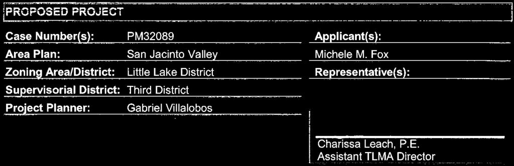
1 1:30 P.M. APRIL 9, 2018 AGENDA RIVERSIDE COUNTY PLANNING DEPARTMENT DIRECTOR S HEARING COUNTY ADMINISTRATIVE CENTER 1 st Floor, Conference Room 2A 4080 Lemon Street, Riverside, CA If you wish to speak, please complete a SPEAKER IDENTIFICATION FORM and give it to the Planning Director. The purpose of the public hearing is to allow interested parties to express their concerns. Please do not repeat information already given. If you have no additional information, but wish to be on record, simply give your name and address and state that you agree with the previous speaker(s). In compliance with the Americans with Disabilities Act, if you require reasonable accommodations please contact the TLMA Commission Secretary at (951) or at esarabia@rivco.org. Requests should be made 72 hours in advance or as soon as possible prior to the scheduled meeting. Alternative formats are available upon request. 1.0 CONSENT CALENDAR: 1.1 FOURTH EXTENSION OF TIME REQUEST for TENTATIVE PARCEL MAP NO Applicant: Michele M. Fox Third Supervisorial District Ramona/Little Lake Zoning District San Jacinto Area Plan: Community Development: Medium Density Residential (CD-MDR) (2-5 du/ac) Location: Northerly of Johnston Avenue, southerly of El Camino Drive, easterly of Meridian Street, and westerly of Stanford Street 4.32 Acres Zoning: Residential Agricultural 1 Acre Min. (R-A-1) Approved Project Description: Subdivision of 4.32 gross acres into four (4) one-acre parcels REQUEST: Fourth Extension of Time Request for Tentative Parcel Map No , extending the expiration date to February 25, Project Planner: Gabriel Villalobos at (951) or at gvillalo@rivco.org. 1.2 THIRD EXTENSION OF TIME REQUEST for TENTATIVE PARCEL MAP NO Applicant: 7 Summit Properties 2, LLC Third Supervisorial District Little Lake Zoning District San Jacinto Area Plan: Community Development: Very Low Density Residential (CD-VLDR) (1 acre min.) Location: Northerly of Segner Drive, southerly of Chambers Avenue, easterly of Hemet Street, and westerly of Lake Street 9.78 Acres Zoning: One-Family Dwellings 1 Acre Min. (R-1-1) Approved Project Description: Schedule H subdivision of 9.78 gross acres into four (4) residential parcels with a minimum lot size of one (1) gross acre and a 1.44 gross acre remainder parcel REQUEST: Third Extension of Time Request for Tentative Parcel Map No , extending the expiration date to April 25, Project Planner: Gabriel Villalobos at (951) or at gvillalo@rivco.org. 1.3 THIRD EXTENSION OF TIME REQUEST for TENTATIVE PARCEL MAP NO M1 Applicant: R&S Land Company, LLC Fourth Supervisorial District Cathedral City/Palm Desert Zoning District Western Coachella Valley Area Plan: Rural Community: Very Low Density Residential (RC-VLDR) (1 acre min.) Location: Easterly and westerly of Painted Canyon Road, southerly of Quail Trail, and northerly of Vista del Palo 5 Acres Zoning: One-Family Dwelling 1 Acre Min. (R-1-1) Approved Project Description: Schedule H land division to divide five (5) acres into three (3) residential parcels REQUEST: Third Extension of Time Request for Tentative Parcel Map No M1, extending the expiration date to April 25, Project Planner: Gabriel Villalobos at (951) or at gvillalo@rivco.org. 2.0 PUBLIC HEARINGS: CONTINUED ITEMS: 1:30 p.m. or as soon as possible thereafter. 2.1 PLOT PLAN NO Intent to Adopt a Mitigated Negative Declaration EA42984 Applicant: Core5 Industrial Partners Engineer/Representative: EPD Solutions First Supervisorial District North Perris Zoning Area Mead Valley Area Plan Community Development: Business Park (CD-BP)( FAR) Zoning: Industrial Park (I-P) Manufacturing Service Commercial (M-SC) Location: Southwesterly corner of Harvill Avenue and Rider Street, and northerly of Placentia Street Acres REQUEST: A Plot Plan to construct a 423,665 sq. ft. warehouse distribution facility; 10,000 sq. ft. of that will be office space with the remaining 413,665 sq. ft. as warehouse use. Continued from February 26, Project Planner: Brett Dawson at (951) or at bdawson@rivco.org. 3.0 PUBLIC HEARINGS: NEW ITEMS: 1:30 p.m. or as soon as possible thereafter. NONE 4.0 PUBLIC COMMENTS: 4080 Lemon Street, 12 th Floor, P.O. Box 1409, Riverside, CA Phone: (951) Fax: (951) El Duna Court, Suite H, Palm Desert, CA Phone: (760) Fax: (760) Final:


2

3

4


5

6


7


8


9

10

11

12

13

14


15

16


17


18

19

20


21

22

23


24
25 THIRD EXTENSION OF TIME REQUEST for TENTATIVE PARCEL MAP NO M1 Directors Hearing Extension of Time Report: April 9, 2018 Page 2 of 3 PROJECT BACKGROUND AND ANALYSIS Background Tentative Parcel Map No was originally approved at Director s Hearing on June 13, It proceeded to the Board of Supervisors and was approved on April 25, A revision/modification to Tentative Parcel Map No was approved on June 12, 2007 by the Planning Director. The Third Extension of Time was received February 20, 2018, ahead of the expiration date of April 25, The applicant and the County discussed conditions of approval and reached consensus on March 6, The County Planning Department, as part of the review of this Extension of Time request, recommends the addition of seven (7) new conditions of approval, in order to be able to make a determination that the project does not adversely affect the general health, safety, and welfare of the public. The applicant was informed of these recommended conditions and has agreed to accept them. Included in this staff report package are the recommended conditions of approval, and the correspondence from the Extension of Time applicant (March 6, 2018) indicating the acceptance of the seven (7) recommended conditions. Unless specifically requested by the applicant, this Extension of Time request will not be discussed at the time it is presented to the Planning Director for approval. State Bills EFFECT OF Senate Bill No (SB1185): On July 15, 2008, AB208 was signed into law, which grants a one-time extension of existing subdivision maps so developers can build immediately when the demand for housing goes up. It gives developers an automatic 12 month extension on previously approved subdivision maps set to expire between July 15, 2008 and January 1, EFFECT OF Assembly Bill No. 333 (AB333): On July 15, 2009, AB333 was signed into law, which grants a one-time extension of existing subdivision maps so developers can build immediately when the demand for housing goes up. It gives developers an automatic 24 month extension on previously approved subdivision maps set to expire between July 15, 2009 and January 1, EFFECT OF Assembly Bill No. 208 (AB208): On July 13, 2011, AB208 was signed into law, which grants a one-time extension of existing subdivision maps so developers can build immediately when the demand for housing goes up. It gives developers an automatic 24 month extension on previously approved subdivision maps set to expire between July 13, 2011 and January 1, EFFECT OF Assembly Bill No. 116 (AB116): On July 11, 2013, AB116 was signed into law, which grants a one-time extension of existing subdivision maps so developers can build immediately when the demand for housing goes up. It gives developers an automatic 24 month extension on previously approved subdivision maps set to expire between January 1, 2000 and July 11, Riverside County Map Extensions Pursuant to County of Riverside Ordinance No. 460 (Subdivision Regulations), tentative tract and parcel maps have an initial life-span approval of 3-years. In addition, a maximum of 5, 1-year extensions may be approved, upon a timely filed extension request, allowing for a total tentative map life-span approval of 8- years. On September 12, 2017, the Board of Supervisors approved an amendment to Ordinance 460,
26 THIRD EXTENSION OF TIME REQUEST for TENTATIVE PARCEL MAP NO M1 Directors Hearing Extension of Time Report: April 9, 2018 Page 3 of 3 replacing the extension time frames to allow for 2, 3-year extensions, for a total tentative map life-span of 9-years. As a result, the total number of years a map may be extended is 6 years. The first and second extensions of time granted 1 year each for a total of 2 years. Upon an approval actin by the Planning Director, subsequent receive and file action by the Board of Supervisors, and the conclusion of the 10-day appeal period, this third extension of time will grant another 3 years, extending the tentative parcel map s expiration date to April 25, If a final map has not been recorded prior to this date, the fourth extension of time request must be filed 30-days prior to map expiration. ENVIRONMENTAL REVIEW The subject case has conformed to the requirements of the California Environmental Quality Act ( CEQA ), and all impacts have been analyzed in order to protect the public health, safety, and welfare. No changes to the approved map are proposed and as a result, no new environmental documentation is required prior to an Extension of Time approval. FINDINGS In order for the County to approve a proposed project, the following findings are required to be made: Extension of Time Findings 1. This Tentative Parcel Map has been found to be consistent with the Riverside County General Plan, pursuant to the originally approved findings and conditions of approval. This Extension of Time proposes no changes to the map design and is therefore still found to be consistent. 2. This Tentative Parcel Map has been found to be consistent with Ordinance No. 348 (Zoning Code) and Ordinance No. 460 (Subdivision Regulations), pursuant to the originally approved findings and conditions of approval. This Extension of Time proposes no changes to the map design and is therefore still found to be consistent. 3. No changes to the approved map are proposed in conjunction with this Extension of Time. All impacts have been analyzed in order to protect the public health, safety, and welfare. Template Location: Y:\Planning Master Forms\Templates\Staff Report\Staff_Report_Template_DH_PC_EOT.docx Template Revision: 03/30/18


27


28


29


30


31

32

33


34


35

36

37

38

39

40

41

42

43


44


45


46


47


48


49


50

51


52


53


54


55


56


57

58

59

60

61


62

63


64

65

66

67


68


69


70

71

72

73

74

75

76

77

78

79


80

81

82

83

84

85


86


87

88

89

90

91

92

93

94

95


96

97

98

99

100

101

102


103

104


105

106


107

108

109

110


111

112

113
114


115


116

117


118

119


120

121

122

123

124

125


126

127


128


129

130

131


132

133

134


135


136

137

138
139

140

141

142

143

144

145

146

147

148

149

150

151


152

153

154

155

156

157

158

159

160

161

162

163

164

165

166

167
168

169

170

171

172

173

174


175

176

177


178


179


180


181


182


183


184


185

186

187

188

189


190
191


192

193

194


195


196


197


198


199

200

201

202


203


204

205

206

207

208


209

210


211

212


213


214


215


216

217


218

219


220


221


222

223

224


225


226


227

228

229

230
231

232


233


234

235


236


237

238

239
240

241

242

243
244


245


246