Understanding and Addressing the New Normal - The Philippine Experience
|
|
|
- Nelson Waters
- 5 years ago
- Views:
Transcription


1 2015/EPWG/SDMOF/003 Agenda: 5.3 Understanding and Addressing the New Normal - The Philippine Experience Submitted by: Philippines 9 th Senior Disaster Management Officials Forum Iloilo, Philippines September 2015

2 Understanding and Addressing the New Normal The Philippine Experience HON. MARIO G. MONTEJO Secretary, Department of Science and Technology
3 How can we give our people earlier warnings when threatened by floods? How will we be impacted by climate change, and how can we prepare our farmers, our industries, our people for the eventuality?

4 Climate Change related S & T Initiatives


5 Climate change is the greatest challenge this generation is facing.

6 Climate change will cause incremental changes to our planet that could have long-term impacts


7 Climate change will affect human health through: Heat Stress Heart and Lung Diseases Increased pollen Vector-based & waterborne diseases


8 Our forest and farms, flora and fauna, crops and livestock, as well as our biodiversity will be affected by climate change


9 Climate Change certainly affects everything in our biosphere, and there is probably no greater common factor than our planet s water.

10

11 According to the Global Climate Risk Index, the Philippines has been ranked 1st in the list of most affected countries.

12 TYPHOON KETSANA (2009)

13 TYPHOON WASHI (2011)

14 TYPHOON HAIYAN (2013)


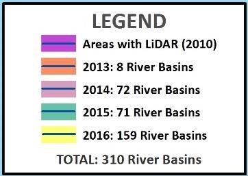
15 DOST S response to President Aquino s directive to put in place a responsive disaster prevention and mitigation program. It is mandated by the government to: 1. Develop an integrated flood early warning -6hr flood warning for communities along 18 major river systems 2. Enhance geo-hazard maps 3. Produce storm surge vulnerability maps


16 DOST is Vice-Chair for Prevention and Mitigation at NDRRMC. As Vice-Chair, we promote a science-based, scenariodriven DRRM approach that harnesses the latest knowledge and technological innovations in disaster science.


17 A science policy to support a DRR strategy that requires hazard specific, area-focused and timebound information. use of advanced disaster science tools multidisciplinary assessment of hazards through collaboration Open data Technology self-reliance developing appropriate technology that enable prevention & mitigation of disasters by LGUs, planners, policy makers, communities, individuals, families


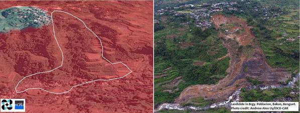
18 Department of Science and Technology With a strategy on achieving technological self reliance in DRRM, the DOST started building capacity in producing highresolution multi-hazard maps and flood hazard models using data from LIDAR technology and increased installation of locally-developed sensors. We focused our science on the factors that kill.

19 75 Rain Gauges 40 Weather Stations 59 Synoptic Stations 23 Agromet Stations TOTAL: 197 Sensors 19

20 20


21 DOST-PAGASA 5 day area-specific weather forecasts 6-month weather outlooks updated every month Annual, area-specific climate change scenarios for the next years, updated 7 years

22 Cagayan River Basin Agno River Basin Pampanga River Basin Marikina River Basin LiDAR 3D Bicol River Basin Mapping To develop 3D and detailed flood hazard maps in Floodplains in 18 major river systems Mag-asawang Tubig, Mindoro Panay River Basin Jalaur River Basin Ilog Hilabangan Cagayan de Oro and Iponan Tagoloan River Basin Agusan River Basin Iligan and Mandulog Agus River Basin Mindanao River Basin Tagum Libuganon Buayan Malungon Davao River Basin
23 LIDAR video here


24 25

25 Storm Surge Hazard Maps: 100% Landslide Hazard Maps: 100% 26


26

27 Sample Storm Surge Map (Tacloban, Leyte)

28
29

30 DOST-ARKO: A nationwide web-mobile based app system for Participatory Disaster Management.
31 Marikina City was hit by 3 extreme weather events in a 2-year period. But unlike in 2009, no casualties were recorded as residents were given advance warning and were evacuated.


32 Super typhoon Bopha hit Mindanao (2012) and caused the overflow of Cagayan de Oro River to levels comparable to Typhoon Sendong (Washi, 2011)). Unlike Typhoon Washi, no casualties were reported for Super Typhoon Bopha in Cagayn de Oro.

33 Rappler Video here


34 1,664 5,773 ZERO CASUALTIES 35

35 R Compostela Municipality Town Proper

36 R Compostela Municipality Town Proper

37 Build Back Better Program

38 LIDAR

39 LIDAR
40
41 Climate Change Geospatial Analytics Platform CC-GAP CC-GAP LAYERS Leptospirosis incidence Dengue vector incidence Coral reef diversity and abundance Coastal and marine ecosystems Aquatic ecosystems Forestry ecosystems Agricultural ecosystems Renewable energy sources Populations (Demographics) Infrastructure METEOROLOGICAL DATA SETS (weather, seasonal, climate change) HI-RESOLUTION 3-D MAPS
42 Climate Change Geospatial Analytics Platform CC-GAP CC-GAP LAYERS Leptospirosis incidence Dengue vector incidence Coral reef diversity and abundance Coastal and marine ecosystems Aquatic ecosystems Forestry ecosystems Agricultural ecosystems Renewable energy sources Populations (Demographics) Infrastructure METEOROLOGICAL DATA SETS (weather, seasonal, climate change) HI-RESOLUTION 3-D MAPS

 Infrastructure METEOROLOGICAL DATA SETS (weather, seasonal, climate change)")
43 Climate Change Geospatial Analytics Platform CC-GAP CC-GAP LAYERS Leptospirosis incidence Dengue vector incidence Coral reef diversity and abundance COASTAL AND MARINE ECOSYSTEMS AQUATIC ECOSYSTEMS FORESTRY ECOSYSTEMS AGRICULTURAL ECOSYSTEMS Renewable energy sources Populations (Demographics) Infrastructure METEOROLOGICAL DATA SETS (weather, seasonal, climate change) HI-RESOLUTION 3-D MAPS


44 Monitoring and Detection of Ecosystems Changes for Enhancing Resilience and Adaptation in the Philippines
45 Thank you and Mabuhay!