Improved MS4 Permit Data Management, Field Inspections, and Annual Reporting
|
|
|
- Letitia Price
- 5 years ago
- Views:
Transcription
1 Improved MS4 Permit Data Management, Field Inspections, and Annual Reporting ESRI Water Utilities Conference February 11, 2015 Joe Lewis, PE, CFM Houston Engineering, Inc.
 Engineering consulting firm Provide GIS and web services and solutions nationally")
2 About Houston Engineering, Inc. (HEI) Engineering consulting firm Provide GIS and web services and solutions nationally In-house application development Water resources Stormwater regulations
 An MS4 is a conveyance or system of conveyances that is: Owned by a state, city, town, village, or other public entity that discharges to US waters.")
3 What is an MS4? Municipal Separate Storm Sewer System (MS4) An MS4 is a conveyance or system of conveyances that is: Owned by a state, city, town, village, or other public entity that discharges to US waters. Designed or used to collect or convey stormwater (including storm drains, pipes, ditches, etc.). Not a combined sewer. Not part of a publicly-owned treatment works (sewage treatment plant).
 Approximately 750 Phase I MS4s (1990) Approximately 6,700 Phase II MS4s (1999) http://water.epa.")
4 MS4 Permit Background National Pollutant Discharge Elimination System (NPDES) authorized by the Clean Water Act in Categories of NPDES Stormwater Program Construction Industrial Municipal (MS4) Approximately 750 Phase I MS4s (1990) Approximately 6,700 Phase II MS4s (1999)

5 MS4 Permit Background Goal: Prevent stormwater runoff from washing harmful pollutants into local surface waters such as streams, rivers, lakes, or coastal waters Regulatory authority is delegated to most states from the EPA


6 EPA MS4 Permit Framework Minimum Control Measures 1. Public Education & Outreach 2. Public Participation 3. Illicit Discharge Detection & Elimination 4. Construction Site Stormwater Runoff Control 5. Post-Construction Stormwater Management 6. Pollution Prevention/Good Housekeeping


7 Why is Mapping an MS4 Important? EPA MS4 Improvement Guide

8 Why is Mapping an MS4 Important? Illicit Discharge Detection & Elimination Outfall Screenings Stormwater network to trace and isolate the source Assess potential from within drainage area

9 Why is Mapping an MS4 Important?
10 MS4 Mapping Requirements Construction Stormwater.... maintain an inventory of all public and private active construction sites.....required to conduct inspections.. Post-construction Stormwater.... maintain an inventory of all post-construction stormwater control measures....document the findings of inspection reports.... Municipal Operations (PP/GH).... maintain an inventory of municipally owned or operated facilities and stormwater controls....

")
11 How is MS4 Permit Data Managed? Paper Spreadsheets Access databases ArcGIS Asset Management Systems (AMS) Permitting & Licensing Systems Commercial Off-the-Shelf (COTS) Applications All of the above
 MS4 size Staff capabilities and preferences Specific MS4 permit requirements Uniqueness of workflows Set up and")
12 What is Best? It Depends: What existing software packages are in use? (AMS, Permitting & Licensing) MS4 size Staff capabilities and preferences Specific MS4 permit requirements Uniqueness of workflows Set up and maintenance costs Esri Insider Blog - Creating a Sustainable GIS. Keith Cooke. December 2014.

13 MS4Front COTS Example Goal: Utilize Technology to Increase Efficiency and Effectiveness Flexible & Configurable Annual Reporting & Documentation Audit Preparedness


14 Workflow Examples Case Study: Plymouth, MN Physical Asset Inventory Field Inspections IDDE Enforcement

15 Asset Inventory: Structural Stormwater BMP ESRI Collector App

16 Asset Inventory: Structural Stormwater BMP Permit Compliance Requirements Routine inspections Maintenance TMDL/pollutant removal Annual reporting


17 Field Inspections: Construction Stormwater Inventory of active construction sites Routine field inspections Violations reports and enforcement actions


18 IDDE Enforcement Discovered during either: Outfall screenings MS4 staff Citizen reports Investigate and report Illicit Discharges discovered in the field Follow up with enforcement actions
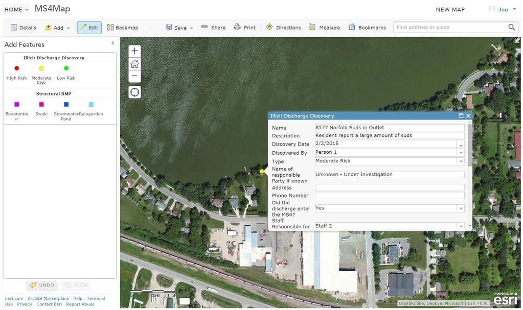

19 IDDE Enforcement
20 Summary MS4 permit background Mapping requirements Data management COTS example Workflows

21 Thank You Joe Lewis, PE, CFM Houston Engineering, Inc