ILLAWARRA COAL BULLI SEAM OPERATIONS
|
|
|
- Poppy Cain
- 5 years ago
- Views:
Transcription

1 ILLAWARRA COAL BULLI SEAM OPERATIONS ANNUAL REVIEW FY2017
2 CONTENTS Title Block Statement of Compliance Introduction Background Overview of Operations Mine Contacts Approvals Operations Summary Exploration Land Preparation Construction Mining Mineral Processing Ore and Product Stockpiles Actions Required From Previous Annual Review Environmental Performance Air Pollution Erosion and Sediment Surface Water Groundwater Contaminated Polluted Land Waste Threatened Flora and Fauna Weeds Blasting Operational Noise Visual, Stray Light Aboriginal Heritage and Natural Heritage Spontaneous Combustion Bushfire Mine Subsidence Hydrocarbon Contamination Methane Ventilation Mine Safety Gas Drainage Hazardous Material Management North Cliff Public Safety Annual Review FY2017 1
3 7. Water Management Water Supply and Use Surface Water Groundwater Management Rainfall Rehabilitation Rehabilitation for the reporting period Rehabilitation Trials and Research Further Development of the Final Rehabilitation Plan Community Environmental Complaints Community Liaison Douglas Park Advisory Panel Community Partnerships Program Camp Quality Convoy Complaints/Enquiries Management Independent Audit Incidents And Non-Compliances During The Reporting Period Activities To Be Completed In The Next Reporting Period Mine Operations Projects Environmental Management References Plans Plan 1 - Regional Location Plan Plan 2 - Appin East (Central) Mine Site Plan 3 Appin West Mine Site Plan 4 No.1 & No.2 Shaft Site Plan 5 No.3 Shaft Site Plan 6 No.6 Shaft Site Plan 7 Douglas North Substation Plan 8 West Cliff South Site Plan 9 West Cliff North Side Plan 10 North Cliff Site Plan 11 Land Preparation Plan West Cliff Emplacement Plan 12 Appin Mine Safety Gas Drainage Rehabilitation Plan 13 Appin East Gas Drainage Plant and Pipeline Upgrade Plan 14 West Cliff Emplacement Cultural Heritage Sites Annual Review FY2017 2
4 Plan 15 Mine Extraction Plan Plan 16 Biodiversity Offset Locations Appendices Appendix A: Annual Rehabilitation Report Appendix B: 2016/17 EPA Annual Return Appendix C: BSO Community Complaints Report FY Appendix D: BSO EPBC Approval 2010/5350 Compliance Report Appendix E: BSO Consent Compliance Report and Summary of Non-compliances Appendix F: Rehabilitation Cost Estimate Annual Review FY2017 3
5 TITLE BLOCK Name of operation Name of operator South32 Illawarra Coal Bulli Seam Operations Development consent / project approval # 08_0150 Name of holder of development consent / project approval Illawarra Coal Holdings Pty Ltd Mining lease # CCL 767, CCL 724 Name of holder of mining lease Water licence # Name of holder of water licence Illawarra Coal Holdings Pty Ltd, Endeavour Coal Pty Ltd 10WA103794; 10WA118766; 10WA Endeavour Coal Pty Ltd MOP/RMP start date 1 Oct 2012 MOP/RMP end date 30 Sept 2019 Annual Review start date 01 July 2016 Annual Review end date 30 June 2017 I, Alex Parro, certify that this audit report is a true and accurate record of the compliance status of South32 Illawarra Coal Bulli Seam Operations for the period 01 July June 2017 and that I am authorised to make this statement on behalf of Illawarra Coal Bulli Seam Operations. Note. a) The Annual Review is an environmental audit for the purposes of section 122B (2) of the Environmental Planning and Assessment Act Section 122E provides that a person must not include false or misleading information (or provide information for inclusion in) an audit report produced to the Minister in connection with an environmental audit if the person knows that the information is false or misleading in a material respect. The maximum penalty is, in the case of a corporation, $1 million and for an individual, $250,000. b) The Crimes Act 1900 contains other offences relating to false and misleading information: section 192G (Intention to defraud by false or misleading statement maximum penalty 5 years imprisonment); sections 307A, 307B and 307C (False or misleading applications/information/documents maximum penalty 2 years imprisonment or $22,000, or both). Name of authorised reporting officer Title of authorised reporting officer Alex Parro Specialist Environment Signature of authorised reporting officer Date 20/9/2017 Annual Review FY2017 4
6 1. STATEMENT OF COMPLIANCE Table 1: Statement of compliance Development Approval Purpose Issue Date Expiry date Compliant? 08_0150 Bulli Seam Operations Project Approval under Section 75J of the EP&A Act /12/ /12/2041 No EPBC 2010/5350 Federal Government approval of the Bulli Seam Operations Project under Sections 130(1) and 133 of the EPBC Act /05/ /05/2042 Yes 10_0079 Appin Ventilation Shaft No.6 Approval under Section 75J of the EP&A Act /05/ /05/2041 Yes 1 EPBC 2010/5722 Mining Lease / Sub- Lease Federal Government approval of the Appin Mine Ventilation Shaft No.6 under Sections 130(1) and 133 of the EPBC Act Number 01/04/ /04/2041 Yes Coal Lease Jan Jan 2034 Yes Mining Lease Dec Mining Lease Jul Jul 2019 Mining Lease Jul Dec 2023 Mining Lease Sep Sep 2033 Mining Lease Jun Jun 2035 Yes Yes Yes Yes No Consolidated Lease Coal Jul Dec 2031 Yes Consolidated Lease Coal Oct Jul 2021 Yes Coal Lease Oct Oct 2033 Mining Purposes Lease Jan Jan 2024 Mining Purposes Lease Jan Jan 2024 Mining Lease Nov Nov 2021 Yes Yes Yes Yes 1 A notice of Modification under Section 75W of the Environmental Planning and Assessment Act October 2016 incorporated the VS#6 Approval requirements into the BSO Approval. Annual Review FY2017 5
7 Table 2: Non-compliances Relevant approval Condition # Condition description (summary) Compliance status Comment Where addressed in Annual Review Surface water discharges Concentration limits were For a summary refer to 08_0150 Sch4.15 exceeding EPL 2504 Non Compliant exceeded at 3 sites during Section 6.3, Table 11 of concentrations limit the reporting period this report Mining Lease # Longwall panel in Area 7 was encroaching ML 1698 which had no approved MOP. Non Compliant on compliant mpliant Illawarra Coal will provide an addendum to the MOP to include ML #1698. NA Refer to Appendix D: BSO EPBC Approval 2010/5350 Compliance Report & Appendix E: BSO Consent Compliance Report and Summary of Non-compliances for more detail. The predictions and Statement of Commitments from the BSO Environmental Assessment (EA) are incorporated into the BSO federal EPBC and state EP&A Approval conditions. Compliance with the state and federal conditions is assessed in the following documents: Appendix D: BSO EPBC Approval 2010/5350 Compliance Report; and Appendix E: BSO Consent Compliance Report and Summary of Non-compliances Annual Review FY2017 6
8 2. INTRODUCTION 2.1. BACKGROUND This Annual Review for the Bulli Seam Operations (BSO) details the environment and community performance for the 12-month period ending 30 th June 2017 and meets the requirements set out in the Annual Review Guidelines (NSW DPE, 2015). The Review has been prepared to meet the requirements of Schedule 6 Condition 4 of the BSO Development Consent and the Department of Resources and Energy (DRE) requirement to submit an Annual Environmental Management Report (AEMR) under the Mining Lease for the BSO. A copy of the report is publicly available via the South32 website under Bulli Seam Operations: OVERVIEW OF OPERATIONS The NSW Government granted approval for the Bulli Seam Operations Project (BSOP) in December The BSOP combines future mining operations and provides for the continuation of coal mining operations at the Appin Mine and West Cliff Colliery. The Bulli Seam underground longwall mining operations have transitioned wholly to the Appin areas (Area 9 and Area 7) following completion of longwall mining activities at West Cliff in early The locations of all sites associated with the BSOP are illustrated in Plan 1 - Regional Location Plan. Appin Appin Mine consists of the merged Appin and Tower collieries. Appin Mine is owned and operated by Endeavour Coal P/L, a subsidiary company of Illawarra Coal Pty Ltd (ICHPL) which is 100% owned by South32. Appin Colliery (located at Appin) commenced operations in 1962 and Tower Colliery (located at Douglas Park) commenced operation in The underground infrastructure, roadways, conveyor and ventilation systems were joined in 2003 to become the Appin Mine. The original Appin Colliery is located adjacent to Appin Village, approximately 37 kilometres Northwest of Wollongong. Tower Colliery (Now Appin West) was officially opened in November Following the sinking of the access and ventilation shafts, underground development of the mine was undertaken from 1978 through to 1988 when longwall operations were introduced. Tower Colliery completed extraction of 20 longwall blocks between 1988 and September The mine was redeveloped underground to establish mining operations in the current longwall Area 7 mining domain. Key areas associated with the current Appin operations include the Appin East (Central) pit top site (Plan 2 - Appin East (Central) Mine Site), the Appin West pit top site (Plan 3 Appin West Mine Site), the Appin East (Central) No.1 and No.2 fan site (Plan 4 No.1 & No.2 Shaft Site), the Appin West No.3 fan site (Plan 5 No.3 Shaft Site), No.6 fan site (Plan 6 No.6 Shaft Site) and the Douglas Park substation site (Plan 7 Douglas North Substation). West Cliff/Appin North West Cliff/Appin North Colliery is located 26km northwest of Wollongong, NSW. West Cliff Colliery is operated by Endeavour Coal Pty Ltd, a subsidiary company of ICHPL with South32 as the parent company. South32 owns 100% of the West Cliff assets. Illawarra Coal has conducted underground coal mining operations at West Cliff since Prior to this, West Cliff was operated by Kembla Coal and Coke Pty Limited (KCC). Longwall mining at West Cliff concluded in early The latest mining area, Area 5, was completed in February 2016 and consists of part of Consolidated Coal Lease 767 and Coal Lease 381 which were both transferred from Appin Colliery to West Cliff Colliery in West Cliff merged with Appin Mine in February Annual Review FY2017 7
9 Key areas of the West Cliff Colliery Site include the pit top (Plan 8 West Cliff South Site), the West Cliff Emplacement Area and Coal Preparation Plant (CPP) at the North Site (Plan 9 West Cliff North Side) and the redundant North Cliff Mine site within the Dharawal National Park Area (Plan 10 North Cliff ) MINE CONTACTS Table 3: Contacts. Position Name Number Acting Vice President Operations Mining Lucas Dow (02) Manager Operations - Processing Sam Knight (02) Specialist Environment Alex Parro (02) Environmental Supervisor Peter McMillan (02) Annual Review FY2017 8
10 3. APPROVALS Tables below describe the Development Approvals, Mining Leases, Licences and Exploration Leases associated with the BSO. Table 4: Development Approvals associated with the BSO Document Issue Date Expiry date Appin Gas Drainage Project Initial Oct 2009 Appin Gas Drainage Project 2010 Dec 2010 Appin Gas Drainage Project 2012 Feb 2012 Bulli Seam Operations Project Approval (NSW Government) 22 Dec Dec 2041 Bulli Seam Operations Project Approval (EPBC Act) 15 May May 2042 No. 6 Ventilation Shaft (NSW Government) 4 May May No. 6 Ventilation Shaft (EPBC Act) 1 Apr Apr 2041 Table 5: Mining Leases and Licences associated with the BSO. Mining Lease / Sub-Lease Number Issue Date Expiry Date Coal Lease Jan Jan 2034 Mining Lease Dec Mining Lease Jul Jul 2019 Mining Lease Jul Dec 2023 Mining Lease Sep Sep 2033 Mining Lease Jun Jun 2035 Consolidated Coal Lease Jul Dec 2031 Consolidated Coal Lease Oct Jul 2021 Coal Lease Oct Oct 2033 Mining Purposes Lease Jan Jan 2024 Mining Purposes Lease Jan Jan 2024 Mining Lease Nov Nov 2021 Environment Protection Licence NSW Office of Water Licences 10WA103794; 1 July June WA118766; 1 July June WA July th February 2018 Table 6: Exploration Leases associated with the BSO. Mining Lease / Sub-Lease Site Issue Date Expiry Date A199 West Cliff 27 Jun Jun A notice of Modification under Section 75W of the Environmental Planning and Assessment Act October 2016 incorporated the VS#6 Approval requirements into the BSO Approval. Annual Review FY2017 9
11 Table 6: Exploration Leases associated with the BSO. A201 Appin 27 Jun Jun 2019 A248 Appin 13 May May 2021 A306 West Cliff 19 Jul Jun 2019 A312 Appin 10 Aug Aug 2018 A370 Appin 8 May Jun 2019 A395 Appin 23 Nov Aug 2018 A396 Appin/West Cliff 28 Jun Jun 2019 A397 West Cliff 4 Aug Jun 2019 A432 West Cliff 12 Feb Aug 2018 EL 4470 Appin 5 Jan Jan, 2021 Annual Review FY

12 4. OPERATIONS SUMMARY 4.1. EXPLORATION During the reporting period, no exploration was conducted for the BSO. No exploration activities were conducted in existing boreholes CCL767 and CCL LAND PREPARATION Mine Safety Gas Drainage Two vertical wells, (one of which had two steered lateral branches and the other one steered lateral branch), were operated to service gas from the extraction of Longwall 707. These wells targeted the Bulgo Sandstone unit, which is in strata above the Bulli Coal seam. These wells are located on ICHPL owned property in paddocks adjacent to Menangle Road, Douglas Park. During 2016/17 two decommissioned wells were rehabilitated. Refer to section 8.1- Rehabilitation for the reporting period for more information. Emplacement Operations The following works were undertaken during the reporting period: Seeding of approximately 7Ha to complete rehabilitation in Stage 2; Extension of the emplacement underdrainage channel and relocation/re-construction of a new dam to capture the underdrainage. Figure 1: Extending the emplacement underdrainage network as Stage 3 coalwash emplacement progresses down the valley. Plan 11 Land Preparation Plan, illustrates the works completed. The rehabilitated emplacement areas were inspected regularly to determine the progress and effectiveness of the rehabilitation. The monitoring program consists of quarterly inspections undertaken by an Illawarra Coal Environmental representative which are supplemented by a more extensive annual monitoring program. The Annual monitoring program was undertaken in spring FY17. The report is provided in Appendix A: Annual Rehabilitation Report CONSTRUCTION The following construction activities were undertaken during the 2016/2017 reporting period: Water Filtration Plant Expansion Works to expand the Appin West Water Filtration Plant continued during the reporting period (Figure 2). The current status of these works is as follows: Annual Review FY


13 Bulk storage total of 2000KL and blending plant completed enabling additional surface storage of treated water and reducing potable water usage for underground operations. Pretreatment system has been installed to increase the capacity to pre-treat underground pump-out water, with ongoing further scoping and design. Full plant expected to be operational in January The new main processing facility, Integrated Membrane Plant 2, is nearing completion. During the reporting period, civil works including clearing and reshaping of designated land at Appin West have been ongoing. Commissioning expected in August Figure 2: Water Filtration Plant Expansion - Main processing facility Appin West Gas Drainage Plant Flaring Units The Appin West (tower) Gas Drainage Plant (GDP) has been upgraded and commissioned to increase the mine gas extraction capacity and provide capacity to flare gas (Figure 3). The upgrade included the installation of a 900mm gas extraction pipe down the existing (unused) bulk coal winder shaft and a 5km 900mm pipe line underground. The flares abate the methane content of the gas and are used when there is more gas available from the mine than can be consumed by EDL. This flaring project generates Australian Carbon Credit Units (ACCU s) as regulated by the Commonwealth Government Clean Energy Regulator. Figure 3: Upgraded gas drainage plant at Appin West Annual Review FY
.")
.")
14 Appin East (Central) Gas Drainage Plant Flaring Units and Overland Gas Extraction Pipe The Appin East Gas Drainage Plant (GDP) is being upgraded to increase gas extraction capacity and to provide some gas flaring capability (Figure 4). As discussed for Appin West, GDP gas flares abate the methane content of the gas and are used when there is more gas available from the mine than can be consumed by EDL, and can potentially generate Australian Carbon Credit Units (ACCU s). The project scope includes the upgrade of: Vent Shaft #3, consisting of: o 900mm pipe extension to underground gas range to bottom of Vent Shaft #3; o 900mm pipe Gas Riser within Vent shaft #3 (downcast) to surface; o Water separator/valve train top of Vent Shaft #3; Appin Central GDP- consisting of: o 1x Vacuum Skid; o 1x Water Skid; o 2x Flare Skids; o Mechanical and electrical interconnection to existing GDP; o Design has included for future Vacuum and water skid connections; An Interconnection Suction Pipeline approx. 4km in length along Brooks Point Road (Figure 5), consisting of: o A buried 1000mm high density poly-ethylene pipeline o A 1000mm galvanised steel pipe crossing the Water NSW channel and adjacent creek. A modification to the Surface Gas Management Plant for Appin East GDP Stage 3 works was approved in February Prior to submission for the application for the pipeline along Brooks Point Road access agreements were sought with landholders for the location of the pipe line. These included Wollondilly Shire Council, Walker Corp and Water NSW. The Brooks Point Road gas extraction pipeline was approved by the Department of Planning on October 2016 as part of the BSO Project Modification (08_0150 MOD 2). The South32 project start date was 15 April 2016, commissioning of the plant is expected in November An overview of the project area can be found in Plan 13. Figure 4: Construction progress of gas drainage plant at Appin East Figure 5: Buried gas pipeline along Brooks Point Road 4.4. MINING Longwall Status The Bulli Seam underground longwall mining operations have transitioned wholly to the Appin areas following completion of longwall mining activities at West Cliff in early Appin and West Cliff (Appin North) mines extract coal from the Bulli Seam within the Southern Coalfield. Annual Review FY
15 During the reporting period, Longwall coal extraction occurred in Appin Areas 7 and 9. Appin Area 7 Longwall 707A extraction was complete at 1034m and as of the 30 th June 2017, Longwall 707B had extracted approximately 1240m, with 815m remaining. As of the 30 th June 2017, Longwall 901 had extracted 2020m, with 12m remaining. Longwall Production Appin and Westcliff extracted 3.99 Million Tonnes of Run of Mine (ROM) coal via roadway development and longwall extraction methods for the reporting period, a 35% decrease from the 2015/16 reporting period. The ROM production levels from FY09 through to the current reporting period are provided in Figure 6. Note that forecast figures for FY18 are not yet available FY09 FY10 FY11 FY12 FY13 FY14 FY15 FY16 FY17 Figure 6: ROM production BSO The average yield for the Bulli Seam operations for the reporting period was 85%. The production and waste summary for the reporting period is provided in Table 7. Table 7: Production Summary Approval Limit Previous Reporting Period This Reporting Period Waste rock/overburden N/A N/A N/A ROM Coal/Ore 10.5MT 6.1MT 3.995MT Coarse Reject (Coal Wash Tonnes) 3 N/A 1.6MT.595MT Saleable Product 9.3MT 4 4.9MT 3.436MT 4.5. MINERAL PROCESSING Mineral processing facilities include the West Cliff Coal Preparation Plant (CPP), the West Cliff Emplacement Area and the Dendrobium CPP (located at the Port Kembla Steelworks). The majority of ROM coal from Appin 3 Total processing waste produced at West Cliff CPP (includes Appin Coal Wash) for Annual Review period only does not include coal wash produced at Dendrobium CPP 4 Transport Limit Annual Review FY
16 Mine is directed to the West Cliff CPP for processing. The Emplacement Area is used to emplace coal wash from the West Cliff CPP and Dendrobium CPP. ROM Coal is transported to West Cliff CPP by: Coal trucks from the Appin East (Central) site, along Appin and Wedderburn Roads. Bulk coal winder at Westcliff (Appin North) transported underground from Appin Area 7 and 9. ROM Coal from Appin Mine is also directed to the Dendrobium CPP on an as required basis to maintain work continuity and maintain reduced stockpile sizes at the Appin Site. ROM coal is transported via Mt Ousley to the Dendrobium CPP (located within the BlueScope Steel complex). Clean coal from the West Cliff CPP is trucked to BlueScope Steel (Port Kembla Steel Works) coal handling facilities or to the Port Kembla Coal Terminal for distribution. Daily road haulage volumes associated with both the Appin and West Cliff sites is available on the South32 website: ORE AND PRODUCT STOCKPILES No coal is stockpiled at the Appin West Site as ROM coal is transported underground to the Appin East (Central) Site. The Appin West coal storage bins are currently under care and maintenance. The Appin East (Central) mine site has a total raw coal stockpiling capacity of up to 50,000 tonnes. The stockpile is recovered with front-end loaders directly into the coal haulage trucks for transport by road to either the West Cliff (Appin North) or Dendrobium CPP s. West Cliff (Appin North) operates six primary coal stockpiles for both clean coal and raw coal. The stockpile capacities at West Cliff (Appin North) are outlined in Table 8. Table 8: West Cliff (Appin North) Stockpiles Capacities Area Capacities No.1 Stockpile No.2 Stockpile No.3 Stockpile No.4 Stockpile No.5 Stockpile No.6 Stockpile 650,000t nominal capacity - 600,000t coking coal, 20,000t jig coal, 30,000t Middlings coal (Note: The capacity of this stockpile has been temporarily reduced to allow space for a temporary lay down area as part of the RCRIP) 150,000t nominal capacity generally coking coal 600,000t nominal capacity generally coking coal 800,000t nominal capacity generally Appin ROM coal 90,000t nominal capacity generally Appin ROM coal 90,000t nominal capacity generally West Cliff (Appin North) ROM A Stockpile and Slope Stability Management Plan is in place to manage the stockpile operations. This plan is a framework document where the operational risks and controls are documented. Risks associated with the stockpile operations are also detailed in the West Cliff (Appin North) CPP Risk Register, which is reviewed regularly by the site management team to test the effectiveness of controls. Monitoring and management review indicates that the current plan effectively controls all potential stockpile management issues effectively. Annual Review FY
17 5. ACTIONS REQUIRED FROM PREVIOUS ANNUAL REVIEW Table 9: Actions from Previous Annual Review Action Required 1. Areas mined in the reporting period and areas proposed to be mine in the next reporting period need to be shown. These were not clearly identified in the 2015/16 AEMR, although they were identified in the 2014/15 AEMR. 2. More comprehensive rehabilitation plans covering all sites should be developed. At present only the West Cliff emplacement area (Plan 11) clearly shows the rehabilitation status. All other sites rely on interpretation of aerial photographs, with no legend showing rehabilitation status 3. Plans need to clearly show the location of rehabilitation progress and new disturbances during the reporting period. Section 8.3, Table 37, of the 2015/16 AEMR identifies 54 ha of new disturbance and 6 ha of additional land under rehabilitation but it is not obvious on Plans which areas these relate to nor any explanation in the text. 4. Plans need to clearly show rehabilitation works undertaken in the reporting period, Plan 11 for West Cliff emplacement does not identify rehabilitation works undertaken in the 2015/16 reporting period. The 2014/15 AEMR had additional detail about what rehabilitation was completed in the reporting period and what was planned in the next year. Where covered in this Annual Review 2014/2015 AEMR Extraction Plan replicated. See Plan 15: Mine Extraction Plan Noted. The only major rehab works during FY17 took place at West Cliff emplacement. Minor rehab works (grass seeding) of decommissioned gas well sites is included in Plan 12. Noted. New disturbance due to the construction of the Gas Pipeline at Appin included in Plan 13. Refer to Plan 11 and 12 which indicate rehabilitation works completed and planned for FY18. Annual Review FY
18 6. ENVIRONMENTAL PERFORMANCE 6.1. AIR POLLUTION Environmental Management Air quality is managed in accordance with the BSO Air Quality and Greenhouse Gas Management Plan (AQMP) which details the air quality and emissions control measures for the project, compliance procedures, monitoring programs, evaluation protocols, notification and communication processes. The AQMP was prepared to comply with the intent and requirements of Condition 12, Schedule 4 of the BSO approval. The objectives of the AQMP are to: Provide the frame work for the responsible management of air quality and emissions associated with the project; Describe the control measures for management of dust, odour, greenhouse gas (GHG) and other emissions to atmosphere; Prevent adverse air quality impacts on the local communities and environment; Describe the compliance criteria for air quality for the project; Describe the air quality monitoring program; Comply with the relevant requirements of Environment Protection Licence (EPL) No and the Bulli Seam Operations (BSO) Project approval; Describe measures for the reduction of project GHG emissions; and Comply with South32 and other relevant standards and requirements. The air quality monitoring program incorporates: Collection and measurement of dust samples from strategically placed dust deposition gauges at representative sites; Use of real-time air quality monitors: fixed Optical Photometers, portable Optical Photometers; Use of a High Volume Air Sampler (HVAS) to determine the land acquisition values; and Dust emission surveys and spot checks using hand held photometers; and Visual inspections and audits. Annual Review FY
19 Table 10: BSO Air Quality Monitoring Sites and their Function Location Equipment and Monitoring Point ID Function Appin East (Central) Appin West Dust Deposition Gauge 14 Dust Deposition Gauge 15 Dust Deposition Gauge 16 Dust Deposition Gauge 17 Dust Deposition Gauge 18 Real-time Photometer (fixed) Photometer ID: (AE-PF3) (NW corner of Appin East (Central) pit top boundary between nearest residential receivers) High Volume Air Sampler High Volume Air Sampler ID:(AE-HV1) Real-time Photometer (fixed) Photometer ID: (AE-PF1) (NE corner of pit top property boundary coal stockpile vehicle entry/exit point) Real-time Photometer (portable) Photometer ID: (AE-PS1) Coal truck exit point onto Appin Road Real-time Photometer (portable) Photometer ID: (AE-PS3) Residential Area to the NW of Appin East (Central) Pit Top Dust Deposition Gauge No.1 Gauge ID: (AW-DD1) Particulate dust deposition rate at SE corner of Stockpile at property boundary Operational Control - Stockpile and internal roadway dust control measures performance reference Particulate dust deposition rate at NE corner of Stockpile Operational Control - Stockpile and internal roadway dust control measures performance reference Particulate dust deposition rate at NW corner of Appin East (Central) pit top property boundary Amenity goal reference Operational Control - Site dust control performance reference Particulate dust deposition rate at NE corner of Appin East (Central) pit top property boundary Amenity goal reference Operational Control - Stockpile and public road dust control measures performance reference Particulate dust deposition rate at SE corner of Stockpile Operational Control - Stockpile and internal roadway dust control measures performance reference Amenity goal reference Real Time Operational Control Site dust control performance reference Amenity goal reference Review against land acquisition levels Real Time Operational Control Real-time monitoring of dust emissions at the coal stockpile area truck entry/exit point onto public roads Real-time Operational Control Stockpile, internal roads and public road dust control measures performance reference monitor Monitor dust emissions at the coal truck exit point onto Appin Road Quarterly survey dust monitoring point Real-time Operational Control Monitor dust emissions at the Appin residential area immediately NW of Appin Pit Top Quarterly survey dust monitoring point Real-time Operational Control Particulate dust deposition rate at Appin West pit top Annual Review FY
20 Table 10: BSO Air Quality Monitoring Sites and their Function Location Equipment and Monitoring Point ID Function Appin West (Appin West pit top adjacent mine access road, employee car park and EDL power plant) Dust Deposition Gauge No.2 Gauge ID: (AW-DD2) (Appin West property boundary at Mine Entrance Point off Douglas Park Drive Real-time Photometer (portable) Photometer ID: (AW-PS1) Northern property boundary between Appin West Pit Top and St. Mary s Towers property Real-time Photometer (portable) Photometer ID: (AE-PS2) Main mine road intersection with Douglas Park Drive Dust Deposition Gauge No.1 Gauge ID: (W-DD1) (West Cliff (Appin North) southern property boundary at the Wedderburn Rd and- Appin Rd junction) Dust Deposition Gauge No.3 Gauge ID: (W-DD3) (West Cliff (Appin North) pit-top south site) Operational Control Site and road dust control measures performance reference Particulate dust deposition rate at the Appin West Mine Gate Entrance Point and the public road Amenity goal reference Operational Control Site and mine access road dust control measures performance reference Monitor dust emissions at the Northern pit top property boundary Quarterly survey dust monitoring point Real-time Operational Control Monitor dust emissions at the mine road intersection with Douglas Park Drive Quarterly survey dust monitoring point Real-time Operational Control Particulate dust deposition rate at the Wedderburn Rd and-appin Rd junction Operational Control Mine entrance road and coal truck dust control measures performance reference Operational Control Site dust control performance reference for the West Cliff (Appin North) pit-top south site Amenity goal reference West (Appin North) Cliff Dust Deposition Gauge No.8 Gauge ID: (W-DD8) (Brennans Creek Dam) Operational Control Site dust control performance reference Indicator for dust deposition rates between the emplacement area activities and the nearest Appin township residential area Baseline and historical dust deposition trends related to the expansion of the emplacement area north towards the nearest residential receivers Dust Deposition Gauge No.10 Gauge ID: (W-DD10) (West Cliff (Appin North) property boundary Site dust control performance reference for product stockpiles and between the product stockpiles adjacent to Wedderburn Road coal truck transport corridor Wedderburn Road and the Dharawal State Conservation Area boundary) Real-time Photometer (fixed) Photometer ID: (W-PF1) Fixed monitor for real-time monitoring of dust emissions at the Wedderburn Road and Appin Road intersection Real-time Operational Control Roadway dust emissions Annual Review FY
21 Table 10: BSO Air Quality Monitoring Sites and their Function Location Equipment and Monitoring Point ID Function (West Cliff (Appin North) southern property boundary at the Wedderburn and Appin Road intersection) Real-time Photometer (portable) Photometer ID: (W-PS1) (Brennans Creek Dam locality to the north of the West Cliff (Appin North) Emplacement Area) Real-time Photometer (portable) Photometer ID: (W-PS2) (Dust emissions survey locality at the western boundary between the emplacement operations and Appin Road) Real-time Photometer (portable) Photometer ID: (W-PS3) (Dust emissions survey locality along Wedderburn Road between the coal stockpiles and the Dharawal National Park) Real-time Photometer (portable) Photometer ID: (W-PS4) (Cataract Scout Camp Reserve to the South West of the West Cliff (Appin North) Site) Monitor real-time dust emissions at the Brennans Creek Dam locality. Quarterly survey dust monitoring point Operational Control and baseline reference point Monitor real-time dust emissions at the zone between the active emplacement area and Appin Road Quarterly survey dust monitoring point Operational Control Monitor real-time dust emissions along Wedderburn Road Quarterly survey dust monitoring point Operational Control Three weather stations and temperature inversion monitoring equipment were installed during FY14. The weather stations are located at Appin East (Central) (with mains power), West Cliff (Appin North) (along Wedderburn Road with solar power) and the Vent Shaft 6 precinct (with solar power). Environmental Performance Results of the air quality monitoring are reported online every 14 days in accordance with Section 66 (6) of the POEO Act and Schedule 6, Condition 11 of the BSO Project Approval; and on an annual basis to the OEH via the EPA Annual Return (Appendix B: 2016/17 EPA Annual Return). The online report is available via the following link: A comprehensive summary of all air monitoring results for the BSO is provided below: BSO Dust Deposition Gauge Monitoring The Appin East (Central) and West Cliff (Appin North) sites non-operational gauges were below the long term criteria/amenity goal of 4 g/m 2 /month for deposited dust during the reporting period (Figure 7). This is evident at all sites located near the perimeter of the Appin and West Cliff (Appin North) sites (i.e. AE-DDG14, 15, 16 and 17; and AW-DD1 and 2; and WC-DD1, 3 and 8). Annual Review FY
 applies to particulate emissions on any residence on privately owned land W-DD10 and AE-DDG18 are operational gauges located within the mine site (i.e. operational land), they provide an indication of effectiveness of the sites immediate dust control measures.")
22 Figure 7: Comparison annual averages from FY12 to FY17 for insoluble solids across the BSO. The long term criteria (amenity goal) applies to particulate emissions on any residence on privately owned land W-DD10 and AE-DDG18 are operational gauges located within the mine site (i.e. operational land), they provide an indication of effectiveness of the sites immediate dust control measures. Real-time Monitoring As described in the BSO AQMP, if the optical photometer at Appin East (Central) (AE-PF3) indicates average dust levels greater than 80% of the Air Quality Criteria (refer to Schedule 4, condition 9 of the BSO project approval) additional monitoring will be undertaken using the HVAS (AE-HV1) to assess compliance. The apparent maximum average PM10 dust levels were measured above the 80% criteria once during This was attributed to regional bush fires and hazard reduction burning. Figure 8: PM10 average 24 hour levels and maximum 24 hour levels at Appin East (Central). Annual Review FY
23 6.2. EROSION AND SEDIMENT Environmental Management Most activities at the Appin East (Central), West and West Cliff pit top sites are undertaken on relatively flat areas. In addition, high activity areas are sealed. There are minimal exposed earthen areas at both sites. Internal unsealed roads are maintained to prevent dust, primarily through dust suppression sprays and water carts. Sediment fences are installed where required to filter sediment from drainage / seepage. Sediment is controlled by a series of dams and water treatment facilities at both sites. Water discharged is monitored for suspended solids. Areas that have the potential to be contaminated by the surface operations at the Appin West Pit Top are contained within the catchment of the Surface Water Dams which are designed to capture and treat a 1:10 year, 72 hour rainfall event. The Surface Water Dam contains a spillway designed for a 1:1000 year rainfall event to maintain the engineering integrity of the structure and reduce the risk of erosion and sediment release. Prior to the release of surface water from the Surface Water Dam (via LDP 23), water passes through a filter unit which is designed to remove suspended solids, oil and grease. The potential for erosion at the emplacement area is managed in accordance with the West Cliff (Appin North) Coal Wash Emplacement Area Management Plan. The following activities are undertaken to minimise the likelihood of erosion within the emplacement area: Compaction of emplaced material; Profiling of finished areas to designed gradients; and Revegetation of emplaced area. Sediment is controlled by a series of sedimentation ponds, which have a combined capacity in excess of 200 ML. Treatment of the water is undertaken at a number of locations across the site prior to release to BCD to meet compliance with EPL limits. The water management system is regularly inspected by the site environmental representative to ensure the system is operating as efficiently as possible. Environmental Performance Routine water quality monitoring of Total Suspended Solids (TSS) across the BSO has not identified any issues associated with erosion and sedimentation. The Appin East (Central) and West and West Cliff (Appin North) sites are operating within the licence limits for TSS SURFACE WATER Environmental Management Surface water management across the BSOP is undertaken in accordance with EPL 2504 and the approved BSO Surface Water Management Plan. The Surface Water Management Plan (SWMP) details the control measures, compliance procedures, monitoring programs, evaluation protocols, notification and communication processes for surface water management for the BSO. This plan has been prepared to satisfy Schedule 4, Condition 16 of the BSO approval. The objectives of the SWMP are to: Provide a water balance for the project including sources, usage and discharge quality; Outline the process to reduce the impacts on biota from the Brennans Creek dam discharge; Establish responsibilities for the surface water management at the BSO operations; Annual Review FY
24 Comply with all relevant regulatory requirements, Environmental Protection Licence 2504 and South32 policies and standards for water management; Describe the water management systems including measures to comply with discharge limits and minimise potable water usage; Outline the framework for water monitoring, auditing and reporting; and Specify investigation and communication processes in response to water related issues and complaints. For specific surface water management strategies and controls, please refer to the SWMP found at: Environmental Performance Results of the surface water monitoring are reported online every 14 days as per the requirements of Section 66 (6) of the POEO Act and Schedule 6, Condition 11 of the BSO Project Approval; and on an annual basis to the OEH via the EPA Annual Return (Appendix B 2015/16 EPA Annual Return). The online report is accessible via the following link: A summary of results from the BSO monitoring program is included in the following sections. Water Quality All but three of the eleven monitoring sites across the BSO achieved compliance with the EPL2504 limits during the reporting period (refer to Table 11). Non-compliances at each of the sites are discussed below. Annual Review FY
25 Table 11: Summary of Compliance with EPL Water Quality Limits Across BSO EPL Monitoring Compliant Comments Site (Y/N) Data Point 4 Yes Point 10 - Copper Point 10 No Point 10 samples were collected for December and February FY17, however administration errors at the consultant laboratory meant that Copper and Manganese levels were not tested. Levels over the rest of the year were significantly below mg/l Jul Aug Sep Oct Nov Dec Jan Feb Mar Apr May Jun Point 10 - Manganese FY17 FY12 Average FY13 Average FY14 Average FY15 Average EPL 90 Percentile Limit FY16 Average compliance limits. mg/l FY17 FY12 Average FY13 Average FY14 Average 40 FY15 Average 20 0 Jul Aug Sep Oct Nov Dec Jan Feb Mar Apr May Jun EPL 90 Percentile Limit FY16 Average Annual Review FY
26 Point 11 Yes Point 12 Yes --- As above Point 18 Yes --- As above Point 19 Yes --- As above Point 20 Yes --- As above Point 22 Yes --- As above Point 23 - ph Point 23 No ph sample result over the EPL100 percentile limit in October. Cause unable to be determined. Results for next sample and all others for FY17 below EPL limit. mg/l Jul Aug Sep Oct Nov Dec Jan Feb Mar Apr May Jun FY17 FY12 Average FY13 Average FY14 Average FY15 Average EPL 100 Percentile Lower Limit FY16 Average EPL 100 Percentile Upper Limit Annual Review FY
27 Point 24 - ph Point 24 No ph sample result under the 100 percentile concentration limit for October. Low ph attributed to operational issue with the water treatment plant. Results the following month were within compliance limits. mg/l Jul Aug Sep Oct Nov Dec Jan Feb Mar Apr May Jun FY17 FY12 Average FY13 Average FY14 Average FY15 Average EPL 100 Percentile Lower Limit FY16 Average EPL 100 Percentile Upper Limit Point 36 Yes - Annual Review FY
28 Water Discharge There have been no instances where discharge volume exceeded the EPL limits for discharge (see Table 12). Note: Manual readings taken from December 2016 onwards due to closure of the 2G automated logger network. Installation of 3G capable water meter loggers is estimated to be complete September Table 12: Summary of Compliance with EPL Discharge Volume Limits Across BSO Monitoring Site EPL Compliant (Y/N) Comments Data Point 4 Yes Feb-14 May-14 Aug-14 Nov-14 Feb-15 May-15 Aug-15 Nov-15 Feb-16 May-16 Aug-16 Nov-16 Feb-17 May-17 Max Flow (kl/day) Min flow (kl/day) Average Flow (kl/day) Point 10 Yes Feb-14 May-14 Aug-14 Nov-14 Feb-15 May-15 Aug-15 Nov-15 Feb-16 May-16 Aug-16 Nov-16 Feb-17 May-17 Max Flow (kl/day) Min flow (kl/day) Average Flow (kl/day) Annual Review FY
29 Table 12: Summary of Compliance with EPL Discharge Volume Limits Across BSO Point 13 Yes Feb-14 May-14 Aug-14 Nov-14 Feb-15 May-15 Aug-15 Nov-15 Feb-16 May-16 Aug-16 Nov-16 Feb-17 May-17 Max Flow (kl/day) Min flow (kl/day) Average Flow (kl/day) Point 18 Yes --- No flow during the period 2500 Point 19 Yes Feb-14 May-14 Aug-14 Nov-14 Feb-15 May-15 Aug-15 Nov-15 Feb-16 May-16 Aug-16 Nov-16 Feb-17 May-17 Max Flow (kl/day) Min flow (kl/day) Average Flow (kl/day) EPL Volume Limit (kl/day) Annual Review FY
30 Table 12: Summary of Compliance with EPL Discharge Volume Limits Across BSO 14 Point 20 Yes Feb-14 Mar-14 Apr-14 May-14 Jun-14 Jul-14 Aug-14 Sep-14 Oct-14 Nov-14 Dec-14 Jan-15 Max Flow (kl/day) Min flow (kl/day) Average Flow (kl/day) EPL Volume Limit (kl/day) Point 22 Yes Feb-14 May-14 Aug-14 Nov-14 Feb-15 May-15 Aug-15 Nov-15 Feb-16 May-16 Aug-16 Nov-16 Feb-17 May-17 Max Flow (kl/day) Min flow (kl/day) Average Flow (kl/day) EPL Volume Limit (kl/day) Annual Review FY
31 Table 12: Summary of Compliance with EPL Discharge Volume Limits Across BSO Point 24 Yes --- 3,500 3,000 2,500 2,000 1,500 1, Feb-14 May-14 Aug-14 Nov-14 Feb-15 May-15 Aug-15 Nov-15 Feb-16 May-16 Aug-16 Nov-16 Feb-17 May-17 Max Flow (kl/day) Min flow (kl/day) Average Flow (kl/day) EPL Volume Limit (kl/day) Annual Review FY
32 Pollution Reduction Programs There are currently no PRP s underway at the BSO. PRP19 and PRP20 have been incorporated into the Georges River Environmental Improvement Program (EIP2). EIP2 Georges River Environmental Improvement Program The EIP for the Georges River incorporates: Improvement projects as per the previous PRP19 requirements; and Monitoring to verify improvements to aquatic health as the above projects are commissioned. Monitoring includes (based on previous PRP20 requirements): o o o o o Quantitative sampling of macroinvertebrates Ecological assessment processes using DNA extracted from sediment; Ecotoxicity testing In-stream water quality; and Laboratory water testing The EIP aims to improve the aquatic health of the Upper Georges River by reducing the concentration of pollutants discharging from Point 10; and monitor the changes to biota in-stream and within the sediment of the Upper Georges River as water quality improvement projects are commissioned. The aims will be verified by: Comparing the Brennans Ck/Georges River sites with reference sites (upstream of the Brennans Creek Confluence) Estimating changes over time in the composition and abundance of in-stream and sediment biota; and Assessing the downstream gradient changes in composition and abundance of in-stream and sediment biota The program will eventually be used to define water quality limits for Point 10 as well as flow requirements. South32 IC holds regular meetings with community stakeholders to review progress of PRP19 projects and monitoring results from PRP20 (Table 13). The Progress Meetings include representatives from the EPA; Georges River Combined Councils Committee (GRCCC); Wollondilly and Campbelltown local councils; The Georges River Environmental Alliance (GREA); National Parks Association of NSW (NPA NSW); Bulli Seam Operations Community Consultative Committee (BSO CCC) and Western Sydney University (WSU). In 2015, a Technical Working Group (TWG) was established (as a subset to the above) to develop water quality and river health objectives for the Upper Georges River. The TWG includes nominated (by the community stakeholders) representatives from the above stakeholders including the GRCCC, WSU, South32 IC and the EPA. The following community stakeholder meetings have been held since 2014: Annual Review FY
33 Table 13: Summary of the Georges River Community Stakeholder Meetings held since Date Type Purpose of Meeting Outcome Spring 2014 Progress Meeting Review of PRP20 results (Yr1) Water strategy for PRP19 and discuss water strategy for endorsed by the attendees. PRP19. Spring 2015 Progress Meeting Review of PRP20 results (Yr2) Consensus to establish a and PRP19 update. Technical Working Group to improve monitoring program under PRP20, develop water quality limits and flow requirements for Point 10. Representatives from GRCCC and Western Sydney University nominated to attend. Autumn 2016 Technical Working Group 1 st Technical Working Group Monitoring results consistent meeting to share monitoring between all parties. results and establish water Agreed on river health objectives. quality limits and flow principals for Point 10. Winter 2016 Progress Meeting followed Site visit to Appin West Water In principal support for flow and by 2 nd Technical Working Filtration Plant and discuss water quality and endorsed Group meeting water quality and flow principals for Point 10. changes to PRP20 monitoring program (increased monitoring frequency etc.). Winter 2016 Technical Working Group Further development of flow and water quality principals. Consensus to replace PRP19/20 with Environmental Improvement Program (this document). South32 IC to submit licence amendment application to include EIP, extend deadline for water quality limits under PRP19 and extend interim limits for Point 10 (with some concentration reductions). The stakeholders will be consulted on the proposed changes. Spring 2016 Progress Meeting Seek endorsement for Endorsement from attendees to submission of the EIP. submit EIP. The attendees requested that the following be noted: They recognised the value of the in-depth consultative process and the goodwill it generates; The group appreciated the effort made by South32 to improve the water quality of the Georges River; The group understood that the current targets need to be realistic Annual Review FY
34 Date Type Purpose of Meeting Outcome and look forward to further planned improvements to ph and salinity. The major water quality improvement projects under EIP2 are summarised below: 1. Water Filtration Plant Upgrade Appin West The aim is to increase processing capacity of mine water and cease mine-water pump-out at West Cliff. This project along with the pre-treatment upgrade and bulk storage upgrades will increase the total treatment capacity and output capacity of the plant. 2. West Cliff Washery Closed Loop Water Management System The aim is to reduce diversion of washery waters into BCD. 3. Coagulant/Flocculant Review Aim is to Reduce aluminium concentration within treatment ponds, Brennans Creek dam (BCD) and discharge into the Georges River. 4. Evaporator/Water Fogger Aim is to reduce the amount of process or mine waters entering BCD through evaporation. Illawarra Coal will discuss results with the stakeholder groups on a regular basis and formally present progress reports in accordance with the following table: Table 14: Summary of reporting and consultation commitments for the Georges River EIP. Report Type or Consultation Frequency Report Due Progress report to EPA on implementation of water improvement projects 6 monthly 30 Dec 2016; 30 June 2017; 30 Dec Stakeholder progress meeting with EPA, GRCCC, CCC, Wollondilly and Campbelltown Councils, WSU, Other interest groups Detailed scientific report on macroinvertebrate and CSIRO monitoring to EPA and loaded onto South32IC Website. Illawarra Coal Community Consultative Committee Technical Working Group Nominated representatives from Stakeholders 6 monthly Oct 2016, Winter and Summer 2017, Winter and Summer 2018; Winter and Summer 2019, Winter 2020 (final meeting). Biennial 31 March 2018; 31 March Regular updates at meetings which are held every two months If monitoring TARP (Table 2) is triggered or to address issues from the Stakeholder Progress Meetings. N/A As required GROUNDWATER No groundwater pollution issues were associated with the BSOP during this reporting period. At West Cliff (Appin North), water make resulting from strata water inflow is collected in pits and low points in the underground workings where it is mixed with water delivered underground from surface storage. This Annual Review FY
35 strata water is brought to the surface either as moisture contained within the coal or as surplus underground water which is pumped to the surface. Once on the surface, the water is piped to the concrete settling tanks where it is used as the main supply for the WCCPP. There were no incidents of ground water pollution within the report period. At Appin, mine water is pumped from the underground working to the surface for treatment in the Appin West WTP from where it is either fed back underground for use or blended with mine water and discharged via LDP CONTAMINATED POLLUTED LAND Environmental Management Appin During the 2010/11 reporting period, Illawarra Coal investigated a small area of the Appin East (Central) site that had formerly been used as a fuel dispensing station which comprised two bowsers, a bunded aboveground diesel tank, and a bunded refuelling pad. The decommissioned fuelling area was being excavated for the purpose of road construction to upgrade coal loading facilities at the site. Preliminary investigations found the decommissioned fuelling area contained elevated concentrations of TPH C10-C36. In response to this finding, Illawarra Coal endeavoured to remove the majority of contaminated material from the decommissioned fuelling area to reduce environmental and health risks and ensure the site is suitable for continued industrial land use. During the excavation and grading works, three previously unknown underground diesel storage tank pits (including a total of four UST s) were discovered. Leakage of diesel was evident in all three UST pits, so after the tanks were removed from site, m of soil was excavated from the walls and floor of each tank pit excavation. Validation sampling of the floor of the excavated area continued to show elevated concentrations of Total Petroleum Hydrocarbons but concentrations of aliphatic and aromatic hydrocarbon compounds were below the NEPC (1999) guidelines for human health. The consultant s validation report indicated that the land remaining in the investigation area and around the UST excavations is suitable for continued industrial land use based on application of the NEPC (1999) guidelines and that the remaining in-situ contamination is not perceived to compromise the ongoing use of the site for industrial purposes. A quarterly monitoring program was established in 2011, with sampling conducted at four locations T1, P1, P2 and P3. T1 is used to monitor for potential contamination from the old Appin Tip which is located upstream of the site (Figure 9). Annual Review FY
 During the 2009/10 reporting period, both West Cliff (Appin North) Colliery and West Cliff (Appin North) CPP underwent Preliminary Contamination Assessments were undertaken")
36 Figure 9: Groundwater Monitoring Bores locations at Appin East (Central). West Cliff (Appin North) During the 2009/10 reporting period, both West Cliff (Appin North) Colliery and West Cliff (Appin North) CPP underwent Preliminary Contamination Assessments were undertaken to review site activities and history, a site inspection to look for indicators of contamination followed by a Risk Assessment conducted with relevant site staff. The site inspection identified a small groundwater seep which was discharging into one of the site dirty water catchment ponds (i.e. Pond P3). The lab analysis of the seep confirmed that the seep contained traces of hydrocarbons and therefore triggered the reporting requirements under Section 60 of the Contaminated Land Management Act 1997 (CLM Act). As part of the notification, Illawarra Coal proposed to undertake a Comprehensive Contamination Assessment to determine the level and extent of contamination (both groundwater and soil) prior to determining an appropriate management strategy. This approach was endorsed by DECCW (now EPA) on the 11 th May The Comprehensive Contamination Site Assessment was completed by an environmental consultant during the 2010/11 reporting period. The assessment involved drilling of nine boreholes (BH1 to BH9), screening of 39 soil samples and laboratory analysis of 15 soil samples. Two groundwater bores (BH8 and BH9) were also installed as part of the investigation. The analysis of the results suggested that the majority of the investigation area appeared to be free of contamination with only four of the samples indicating relatively low levels of contamination, three of which were located within 2.5 metres of a recently decommissioned and removed UPSS. The concentrations were relatively low in the context of an industrial site and analysis indicates the concentrations were likely to be well below NEPM health investigation guidelines for the industrial land use. In addition, a preliminary assessment Annual Review FY
37 of the soils waste classification suggested that the soil is likely to be classified as general solid waste. Ongoing monitoring of BH8 has been carried out during the reporting period. Environmental Performance Appin Since the first round of monitoring, all samples across all sites have been uncontaminated with respect to BTEX and TPH. During the reporting period Boreholes P2 and P3 indicated elevated levels of TPH (Figure 10). Samples taken in February 2017 revealed higher levels than previously seen at any of the boreholes. These results were attributed to contamination of the samples as the most recent samples taken in May indicated TPH levels below or close to lowest observable limit (LOR- 50 µg/l). The most recent sample taken at T1 showed TPH levels below LOR indicating that there was no potential contamination from the old Appin Tip. Figure 10: Total Petroleum Hydrocarbons (C10 C36 Fraction (Sum)) since monitoring began in 2012 at Appin East (Central). West Cliff (Appin North) During the reporting period, all samples from BH8 were uncontaminated with respect to BTEX and TPH. Since the first sampling campaign, TPH concentrations had generally trended downwards in BH8. TPH concentrations had ranged between 2050 µg/l in Feb 2012 down to 260 µg/l in August 2012 (Figure 11). The carbon chain range for BH8 are between C10 C28 indicating that diesel is a potential source of contamination at this location. This is consistent with data reported in the validation report which was submitted to the EPA in August 2010 which indicated there was a small hot spot of contamination remaining. During the reporting period TPH was below the observable limit. Annual Review FY
38 Figure 11: Total Petroleum Hydrocarbons (C10 C36 Fraction (Sum) µg/l) since monitoring began in 2012 in BH8 at West Cliff (Appin North) WASTE General Waste General waste is segregated on all sites to maximise reuse and recycling opportunities in accordance with the BSO Waste Management Plan. The waste streams applicable to the BSO are specified in Table 15 below. Table 15: The main waste streams for the BSO. Waste Stream Treatment Timber Cardboard and paper Printer Cartridges Oil Oily waters Steel and Scrap Metal Sewage effluent (treated) Industrial filters Bathhouse water Particulate filter Hazardous waste General Waste Recycled off site Recycled off site Recycled off site Recycled off site Recycled or disposed off-site Recycled off site West Cliff (Appin North) Treatment and irrigation on site. Appin West Treatment and irrigation onsite Appin East (Central) Disposed via town sewerage system Off-site treatment and disposal West Cliff (Appin North) - Spray irrigated to land on site Appin West - Spray irrigated to land on site Appin East (Central) Transported to licensed sewage treatment facility for first part of reporting period. Connected to town sewerage system for later part of reporting period. Off-site treatment and disposal Off-site treatment and disposal Landfill Solid waste volumes generated at the BSO (including the Appin West, Appin East (Central) and West Cliff (Appin North) sites) for the reporting period are provided in Table 16. Annual Review FY
39 Table 16: Waste Volumes BSO General Waste Industrial Waste (Filters) Timber Metal Cardboard Commingle Quantity (Tonnes) FY Quantity (Tonnes) FY Quantity (Tonnes) FY Approximately 21% less waste was disposed as landfill for the reporting period when compared to the previous financial year. Coal Wash Coal wash is a by-product of processing ROM coal. During the reporting period, a total of 967,400 tonnes of coal wash (includes Dendrobium, Appin and West Cliff (Appin North)) was emplaced at the West Cliff (Appin North) Emplacement Area. Illawarra Coal received approval to expand the West Cliff (Appin North) Emplacement Area (i.e. Stage 3) from the DoP on the 20 December The Stage 3 Emplacement Area provides an additional 33.5 million tonnes of coal wash emplacement (refer to table below) with an expected emplacement life of 10 to 15 years (based on projected coal wash volumes). Illawarra Coal received approval for Stage 4 of the West Cliff (Appin North) Emplacement Area on the 22nd December The Stage 4 Emplacement Area will provide an additional 59.4 million tonnes of coal wash emplacement (refer to table below) with an expected life to Table 17 outlines the capacity and status of each of the West Cliff (Appin North) coal wash emplacement areas. Table 17: West Cliff (Appin North) Emplacement Area Capacity and Status. Emplacement Stage Estimated Capacity Emplacement Status Complete Complete Current Not Yet Commenced Coal Wash Research During FY17, Illawarra Coal diverted approx. 860,000T of coal wash for beneficial uses in the local region (i.e. as an engineered fill, and for the development of arterial and agricultural roads), with over 3Mt diverted since Illawarra Coal currently has a long-term contract in place with Lend Lease to provide large volumes of engineered fill for a new housing estate at Calderwood. Illawarra Coal is also looking to provide Coal Wash as an engineered fill for a major RMS road infrastructure project, starting in Illawarra Coal is continuing with its Coal Wash Road Base project, which utilises coal wash with other recycled materials such as fly ash to produce a material suitable for a variety of applications. In late 2014, the RMS published a specification of this material based on the success in trials of this product, and local councils have undertaken trials of this product in their respective areas. Following on from the success of these trials, Illawarra Coal has aligned itself with three universities (University of Wollongong, University of Sydney and University of Newcastle) and 4 other industry partners (RMS, Douglas Partners, Infratech and Stabilco) and has been successful in securing an ARC-Linkage Project grant of $590k to conduct research into the long term performance of this material in roads and railways. The project kicked off in 2017, and will take 3 years to complete. Annual Review FY
40 Illawarra Coal will continue to research, develop and implement alternative uses for coal wash in order to minimise the volume emplaced at the West Cliff (Appin North) site in future. Underground Coal Wash Emplacement Illawarra Coal submitted a revised Underground Coal Wash Emplacement Trial to the Department in The revised Plan proposed to defer the trial for 5 years for the following reasons: Illawarra Coal s focus on diverting material from surface emplacement via alternative beneficial uses continues to provide good outcomes; The declaration of Dharawal National Park has eliminated a significant area of potentially suitable roadways for underground coalwash emplacement; and The trial replicates what has been demonstrated by another Southern District Colliery. The key aspects of the Plan remained valid during the reporting period and detailed reports and presentations will be made available at the completion of major research milestones. Sewage During the reporting period, ongoing monitoring and inspections were conducted on the two BSO sewage treatment plants (Appin West and West Cliff (Appin North)). Appin East (Central) is connected to town sewage. There is a Smith and Loveless Sewage Treatment Plant (STP) on the Appin West and West Cliff (Appin North) sites that discharge into maturation ponds. The treated effluent is irrigated on site via LDP 22 (Appin West) and LDP 4 (West Cliff (Appin North)). A waste water maintenance contractor is periodically used to assist with the operational aspects of the Appin and West Cliff (Appin North) Sewerage treatment systems to minimise the likelihood of any issues occurring. During FY17 an additional 5.6 ha of land adjacent to the existing treated effluent irrigation area at Appin West was used for effluent irrigation. The rented land is owned by the Catholic Church and is known as St Mary s Tower. An Environmental Assessment of the land was prepared by Illawarra Coal prior to commencement of effluent irrigation. Land monitoring and soil testing will be ongoing for the duration of irrigation on the area to ensure any potential damage is identified and mitigated. Monitoring of the STP effluent at both sites is undertaken on a monthly basis in accordance with conditions contained with EPL Results of the monitoring are reported on an annual basis to the EPA via the EPA Annual Return and are made available to the public via the web based environmental monitoring report which is issued every 14 days. Appin WAC Disposal Weak Acid Cation Regenerate (WAC), a waste stream from the Appin water treatment plant, is transported offsite to a licensed Waste Management Facility. The total volume of WAC transported off-site during the reporting period was 3.78 ML, an increase of 0.18 ML when compared to the previous reporting period. Appin Water Treatment Plant Biological Sludge The Appin backwash treatment plant was commissioned in April One of the by-products of the Backwash Treatment process is an organic sludge. The total volume of sludge reused as a soil conditioner offsite at the Emplacement Operations during the reporting period was approximately KL THREATENED FLORA AND FAUNA Environmental Management Threatened Flora and Fauna communities at the BSO are managed in accordance with the following approved plans: West Cliff (Appin North) Coal Wash Emplacement Area Management Plan; Annual Review FY
41 Broad-headed Snake Management Plan; Southern Brown Bandicoot Management Plan; Persoonia hirsuta Offset Management Plan; Strategic Biodiversity Offset Plan Ventilation Shaft No.6 Biodiversity Management Plan; Sandstone Shale Transition Forest Offset Management Plan; and Surface and Groundwater Quality Monitoring and Adaptive Management Plan for Water Sensitive EPBC Listed Species. These plans include the management and mitigation measures for threatened species or habitats that occur on our sites and are available on the South 32 website: The Persoonia hirsuta is listed as Endangered under both the NSW Threatened Species Conservation Act and Commonwealth EPBC. A substantial population of the Persoonia hirsuta is known to exist on the West Cliff (Appin North) Colliery Lease. A number of the Persoonia hirsuta are located within operational areas such as high voltage transmission lines on site. Acacia bynoeana is listed as Threatened under the NSW Threatened Species Conservation Act and Vulnerable under the Commonwealth EPBC. The species has previously been recorded along existing roads, tracks and disturbed areas at West Cliff (Appin North). Pultenaea aristata is listed as Vulnerable under the NSW Threatened Species Conservation Act and the Commonwealth EPBC. The species has been recorded in areas of impeded drainage in woodland adjoining the main access road and in the vicinity of the southern extent of Stage 3 Emplacement Area. 41 P. aristata have been identified within the rehabilitating emplacement area (See Appendix A: Annual Rehabilitation Report). Flora and Fauna aspects associated with mine subsidence are detailed in section Environmental Performance Broad-headed Snake and Southern Brown Bandicoot There have been no instances that required the implementation of mitigation measures for Broad-headed Snakes (as outlined in the approved management plan). There were no instances that required implementation of mitigation measures for the Southern Brown Bandicoot. SBB and BHS Monitoring Program NSW OEH In accordance with Condition 7(b) of the EPBC Approval 2010/5350, South32IC has provided funding of $250,000 towards the NSW OEH Broad-headed Snake and Southern Brown Bandicoot Program. A summary of the results from the program is as follows (information provided by OEH): The southern brown bandicoot and broad-headed snake offset project aimed to improve our understanding of the distribution and threats operating on these two species across the Woronora Plateau over a three year. Systematic survey. For the broad-headed snake, this was undertaken across 259 sites and 97 individuals were located over 59 sites scattered across the study area. Threats to individuals and their habitat identified include coal mining activity and infrastructure, predation from introduced predators (foxes, feral cats); poaching/reptile Annual Review FY
42 searching, rock displacement & disturbance from recreation activities, disturbance from feral herbivores (deer, goats), fire and road kill. On-ground works undertaken as part of this project attempted to address habitat disturbance and collection within Dharawal National Park where access to the public is not prohibited, by the installation of a new locking system across the reserve, targeted reinforcement of entry points via placement of concrete blocks and habitat deterrent signage. Although opportunities for habitat restoration was limited one large restoration site was established within the Metropolitan catchment lands where a large cache of bushrock was detected. This bushrock was redeployed across nearby rock platforms to recreate winter refugia habitat. Monitoring of this site is ongoing with early colonisation of habitat by common BHS prey species. Management and monitoring of this species across the study area has substantially informed future management and monitoring across this area and is currently funded under the OEH Saving our Species program. To investigate the distribution of the southern brown bandicoot across the study area 591 representative sites were sampled via remote cameras over the life of the project. These investigations sampled all broad vegetation types and resulted in a sampling effort of 25,115 trapnights and analysis of 770,312 images. This camera work was supplemented by the opportunistic collection of over 350 predator scats during camera deployment. Despite this extensive survey effort no evidence of the southern brown bandicoot was detected. However, a substantial dataset was collected of other vertebrate fauna across the study area whereby 95 different species were detected on camera. This included seven threatened species, namely the koala, heath monitor, eastern bristlebird eastern pygmy possum, long-nosed potoroo, squirrel glider and chestnut quailthrush. Unfortunately introduced predators particularly the fox and feral cat are also prevalent across the study area with detections at 249 and 79 of the 591 cameras sites respectively. In addition, 299 of the 352 scats collected where fox while a further 16 were cat. Information from both components of this project will be shared with the land owners and is intended inform land management particularly around threatened species and their habitat. Persoonia hirsuta Overview Illawarra Coal conducted its fourth round of annual condition monitoring of the Persoonia hirsuta population at West Cliff. The monitoring was undertaken in accordance with the approved P. hirsuta Offset Management Plan, which complies with EPBC Approval Condition 2. The monitoring was completed over 2 days in December 2016 during the peak flowering period for the species. Results Offset Population The total count of live plants within the Offset in 2016 was 11: 26 plants have died likely due to age related causes (since the baseline in 2012); 16 plants were burned as part of the approved conservation burn trial in April 2016; and No new plants were identified in the Offset during Offset Population to (Baseline) Poor Moderate Good Total Offset Annual Review FY
43 Figure 12: Comparison of Persoonia hirsuta condition and population within the Offset across years. West Cliff Other Areas A further 32 individuals were monitored within the surrounding West Cliff lease: 10 of which were recorded in 2012; 5 in 2013; 13 in 2014 (includes 1 plant identified in the Stage 2 emplacement rehabilitation); 4 in 2015; and 2 in Three of the plants listed above have died: One of the plants was unable to be re-located in 2016 and is presumed dead (for reasons unknown); Two of the plants have died, potentially due to increased exposure to higher temperatures and sunlight due to nearby approved vegetation management activities (under powerlines). Total Site Count The total count for P.hirsuta plants at West Cliff in spring 2016 was 40, including 24 plants that have been identified post baseline. Excluding these, there has been a decrease of 47 plants when compared to the 2012 baseline population of 63. The 47 includes the 16 plants that were burned as part of the conservation burn trial in April This was in accordance with Illawarra Coal s research strategy as stated in the approved P. hirsuta Offset Management Plan. All Plants to (Baseline) Poor Moderate Good Total Figure 13: Comparison of condition and population of all plants across years Discussion The vegetation in the Offset and surrounding West Cliff site remains in good condition. The conservation burn area is regenerating well. Illawarra Coal is monitoring the site for emergent seedlings. The overall health of the core population of P. hirsuta is declining as the plants are reaching the end of their natural lifecycle. As per previous years, recruitment is limited to previously disturbed areas and the majority of adult plants (in good condition) are situated either below a powerline easement or adjacent to a fire trail. Annual Review FY
44 Ongoing Research and Conservation Management In accordance with EPBC 2010/5350 Condition 3, Illawarra Coal is undertaking targeted research on Persoonia hirsuta. The research consists of a series of honours projects by University of Wollongong and research undertaken by Mt Annan Royal Botanic Gardens. The following UOW projects have been completed to date: 1. Honours project #1 titled The Demography and Habitat Characteristics of the Endangered Persoonia hirsuta (completed 2013) 2. Honours project #2 titled Conservation genetics of the rare and endangered plant, Persoonia hirsuta (proteaceae) (completed 2015) 3. Honours Project #3 (Continuation of #2) titled Can the seed bank act as a reserviour of genetic diversity? A Conservation genetic study of Persoonia hirsuta (Completed 2016). UOW will publish the outcomes from this work. We expect the final paper/s to be available late In addition, Mt Annan Royal Botanic Gardens (RBG) are undertaking trial propagation using cuttings collected from the West Cliff and other populations. The aim is to develop a population of stock plants at the nursery, which will be used to collect seed for germination trials and translocation. This project is ongoing; progress has been slow due to the overall success rate for this species. Mt Annan RBG (in collaboration with Illawarra Coal and Centennial Coal) has been granted ACARP funding to conduct research on seed germination biology and alternative ex situ storage of Persoonia germplasm for restoration. This project will address two main questions: 1) how to effectively propagate Persoonia species (both rare and common) for mine rehabilitation work; and, 2) what are the most appropriate ex situ conservation options to ensure restoration success. The project commenced February 2015 and was partially completed in March This project was granted further funding in 2016 and will be extended for two years (conclude 2019) to include high interest native plants in mine site restoration programs and propagation, translocation and re-introduction of plants for the establishment of offset populations. IC requested an extension to the research report deadline to 15 May The extension was granted on 15 th May Persoonia Ecological Burn In April 2016, Illawarra Coal engaged the NSW Rural Fire Service to conduct an ecological burn in the West Cliff (Appin North) Persoonia Offset. The aim of the burn was to promote germination of P. hirsuta and increase the density of the species within the area. The burn site is being monitored for new seedlings; however, no new seedlings have been found to date. Shale Sandstone Transition Forest Offset The EPBC Approval conditions for the Bulli Seam Operations (BSO) require a biodiversity offset of at least 44.9 Ha of Shale Sandstone Transition Forest (SSTF) as well as an Offset Management Plan. In 2012, IC identified a suitable site in in Douglas Park NSW, within the Wollondilly Local Government Area (LGA). The land is approximately 86 hectares in size which includes bushland, a transmission line easement, a small paddock, and several access tracks. The Offset area is comprised of two parcels of land, separated from each other by Douglas Park Drive. In-line with the EPBC conditions at the time (2012), IC provided an Offset Management Plan as well as ecological survey information. The original SSTF Offset Plan was approved by the Department of the Environment (DOTE) in June In 2014, IC was granted an additional 18 months to secure the Offset for long term conservation purposes. Annual Review FY
45 The northern area is located within Lot 1 DP It is bordered to the north by private property, the Cataract River to the east and south, and Douglas Park Drive to the west. The southern area is located within Lot 1 DP and Lot 7 DP It is bordered by Douglas Park Drive to the east, Clements Creek to the north and west, and private property to the south. The Appin West Colliery Pit-top is located approximately 200 metres to the north on the opposite side of Clements Creek. The land is currently owned by Illawarra Coal (Refer to Plan 3 Appin West Mine Site and Plan 16 Biodiversity Offset Locations). Past land use of the study area involved agricultural practices and probably timber cutting. The study area is connected to other vegetated areas along the Cataract River to the north and Clements Creek to the south. In October 2015, IC made an application to NSW Office of Environment & Heritage (OEH) to have the SSTF offset secured via a BioBanking Agreement under Part 7A Division 2 of the Threatened Species Conservation Act The BioBanking Agreement was finalised and executed on 1st February The Offset is now managed in accordance with the BioBanking Agreement, ID Number 215. Ventilation Shaft No.6 Offset The Appin No. 6 Ventilation Shaft Site project approval requires Illawarra Coal Illawarra Coal to secure, manage and monitor an 8.7 hectare offset of Cumberland Plain Woodland (CPW) such that an improve or maintain outcome would be achieved for threatened biodiversity. The offset area is known as MZ5 and is located to the north of the Appin No. 6 Ventilation Shaft site on the property known as Mountbatten Stud at Douglas Park NSW (Figure 1). An initial assessment of the proposed offset area was conducted by Niche in December 2010 to assess the suitability of the site to be used as an offset for the unavoidable impacts associated with the development site. Niche determined that the site was indeed CPW and, under management, would improve to benchmark condition over time. The initial inspection of MZ5 also resulted in the discovery of a population of the threatened plant, Pimelea spicata, adding significant conservation value to the offset area. In accepting the offset proposal, the DOPE and DOTEE, provided a number of approval conditions relating to the reservation, management and monitoring of management actions within MZ5. One of the conditions required Illawarra Coal to implement a formal monitoring program for both the management of the native vegetation on the site and the extent and health of the Pimelea spicata population. The results of the monitoring survey in relation to the floristic composition and improvement through the site, indicate that, on average, the bushland on the site is outside of benchmark attribute values for the Cumberland Plain Woodland but is showing trends towards benchmark values. An assessment of the change in size and distribution of the threatened plant population of Pimelea spicata (spiked rice-flower) was undertaken as part of the 2016/17 monitoring program. The local population within MZ5 in 2017 is estimated at 9,702 individuals. This is an increase from an estimated population of 6,260 individuals in This increase in population demonstrates that site management to date has been beneficial to the species. Dendrobium and BSO Project Strategic Biodiversity Offset In 2016, the DOPE approved Illawarra Coals proposal to provide an offset for mining impacts from the Dendrobium Coal Mine and Bulli Seam Operations Project through the conservation of a 598 hectare site at Maddens Plains near Helensburgh. DOPE and the Office of Environment and Heritage (OEH) support South32 s intention to secure the Maddens Plains site in perpetuity by transferring this land to the National Park estate. The offset land at Maddens Plains meets the offset requirements for any impacts on: The upland swamps at the Dendrobium Coal Mine; and The vegetation communities at the BSO Annual Review FY
46 Refer to Plan 16 for the locations of all biodiversity offsets across the BSO WEEDS Environmental Management and Performance Appin Environmental inspections (which include weed identification) are undertaken at the Appin East (Central) and Appin West sites. When noxious weeds are identified they are removed and treated as per the approved Waste Management Plan. Maps outlining the weed growth areas are provided to the grounds maintenance personnel to assist with identifying the target locations. During the reporting period active weed management included: Regular spaying of weed zones by licensed contractors; Regular audits of the effectiveness of weed management activities West Cliff (Appin North) Ongoing grounds maintenance is undertaken by a contractor who has a regular schedule of work. The annual emplacement rehabilitation monitoring program includes the identification and proposed management strategies to control weed growth within the emplacement areas. Focus areas for weed control are determined through this program. Records of areas targeted are maintained for future reference. Targeted weed control within the emplacement area was undertaken by a licenced contractor during the year which included weed spraying and slashing of perennial grasses BLASTING No surface blasting activities are undertaken on site. Minor blasting activities underground are undertaken using approved management plans OPERATIONAL NOISE Environmental Management Noise across the BSOP is managed in accordance with the approved BSO Noise Management Plan. The Plan was prepared to satisfy Schedule 4, Condition 5 of the BSO approval and details the relevant noise criteria, compliance procedures and controls relating to the mining operations. The objectives of this plan are to: Provide the frame work for the responsible management of noise emissions associated with the project; Describe the control measures for management of noise emissions; Prevent adverse noise impacts on the amenity of local communities and environment; Describe compliance criteria for noise for the project; Describe compliance criteria exceedance assessment protocols; Describe the noise monitoring program; Comply with the relevant requirements of Environment Protection Licence (EPL) No and the BSO Project approval; Annual Review FY
47 Describe measures for the reduction of noise emissions; and Comply with South32 and other relevant standards and requirements. A copy of the Plan is available on the South32 website: Monitoring Program A noise monitoring program has been developed to comply with Condition 5(f) of Schedule 4 of the Project Approval. The objectives of the noise monitoring program are to: Measure noise levels experienced by nearby residential receivers; Assess the effectiveness of the existing noise controls; Measure project related noise levels; Detect any adverse developments in Project noise; Measure Residential Background Level (RBL) noise; and Acquire sufficient and reliable data to inform the assessment of compliance with noise criteria Assessment criteria have been established for each monitoring location, as outlined in Table 18. The criteria enables an assessment of compliance to be made against the noise levels outlined in the Project Approval. The site specific assessment criteria were developed using the following methodology: Adoption of the most stringent noise levels as outlined in the Development Consent noise criteria; and Where relevant, the noise levels were adjusted (to take into account monitoring location verse receivers) using the noise contours from the BSO Noise Impact Assessment. The program consists of continuous, real-time noise monitoring and attended monitoring using handheld portable monitors. The attended monitoring is undertaken at the nominated monitoring locations to confirm compliance. Annual Review FY
48 Table 18: Noise Survey Points and Results. Survey Type Receivers Point ID Assessment Criteria LAeq (15 LA1 (1 min) min) Locality Function Data Summary Comments AE-NS4 Realtime and attended Appin township 43 (day, evening and night) 52 (night) Located in paddock between Illawarra and Toggarai St North of Pit Top behind receiver 137 Noise from AE LAeq(15) Noise - AE-NS4 Day Evening Night FY15 FY16 FY17 Mine Related Assessment Criteria Compliant AE-NS5 Attended Appin No.1 and No.2 receivers 40 (day, evening and night) 50 (night) Northampton Dale Road between the No.2 Shaft Site and power plant project and the nearest residential receivers in the South to East quadrant from site. Noise levels between Shaft Site and the nearest residential receivers to the SE LAeq(15) Noise - AE-NS5 Day Evening Night FY15 FY16 FY17 Mine Related Assessment Criteria Compliant Noise - AE-NS5 AW-NS5 Realtime and attended All other Appin West receivers 39 (day and evening) 35 (night) 53 (night) Between nearest residential receivers on Douglas Park Drive and the Appin West Pit Top Noise level at AW property boundary; Noise levels between AW and nearest residential receivers on Douglas Park Drive LAeq(15) Day Evening Night FY15 FY16 FY17 Mine Related Assessment Criteria Compliant Annual Review FY
49 Table 18: Noise Survey Points and Results. AW-NS4 Attended Appin West receivers South-west of Appin West; and Appin West receivers near Hume Highway 39 (day and evening) 35 (night) 49 (night) Ashwood Road, South-west of Appin West Pit Top Noise level for Appin West Receivers Southwest of Appin West; and Appin West Receivers near Hume Highway LAeq(15) Noise - AW-NS4 Day Evening Night FY15 FY16 FY17 Mine Related Assessment Criteria (Day/Evening) Mine Related Assessment Criteria (Night) Compliant Noise - AW-NS3 AW-NS3 Attended Appin No.3 receivers 41 (day, evening and night) 49 (night) Appin No.3 Shaft site at end of Brookes Pt Road Noise level at Brookes Pt Road and nearest residential receivers to the East of the shaft site LAeq(15) Day Evening Night FY15 FY16 FY17 Mine Related Assessment Criteria Compliant Noise - WC-NS1 W-NS1 Attended N/A Baseline data for West Cliff (Appin North) only N/A N/A West Cliff (Appin North) Brennans Creek Dam Noise level between the West Cliff (Appin North) emplacement area and the nearest residential receivers to the North of site LAeq(15) Day Evening Night FY15 FY16 FY17 Compliant Annual Review FY
50 Table 18: Noise Survey Points and Results. Noise - VS6 North VS6 North Attended Douglas Park Township and Receivers 45 (day and evening) 39 (night) 49 (night) Residential area between Camden Rd and Harris Ck North West of VS6 Noise level between VS6 area and the nearest residential receivers to the North West of site LAeq(15) Day Evening Night FY16 FY17 Mine Related Assessment Criteria (Day/Evening) Mine Related Assessment Criteria (Night) Compliant Noise - VS6 Central VS6 Central Attended Douglas Park Township and Receivers 50 (day) 45 evening) 39 (night) 49 (night) Duggan street behind Douglas Park Public School Noise level between VS6 area and the nearest residential receivers to the West of site LAeq(15) Day Evening Night FY16 FY17 Mine Related Assessment Criteria (Day) Mine Related Assessment Criteria (Evening) Mine Related Assessment Criteria (Night) Compliant Noise - VS6 South VS6 South Attended Douglas Park Township and Receivers 50 (day) 45 evening) 39 (night) 49 (night) Adjacent to rail corridor on Station Street, Douglas Park Noise level between VS6 area and the nearest residential receivers to the South West of site LAeq(15) Day Evening Night FY16 FY17 Mine Related Assessment Criteria (Day) Mine Related Assessment Criteria (Evening) Mine Related Assessment Criteria (Night) Compliant Annual Review FY
51 Environmental Performance Quarterly attended and real-time monitoring was conducted in accordance with the approved management plan for the reporting period. Results of the monitoring are reported online and summarised in Table 18. The assessed noise levels generated from the Bulli Seam Operations were below the Day, Evening and Night assessment criteria in Table 18. During the reporting period a noise wall was erected at Appin West Mine Site between the Gas Drainage Plant Flaring Units and the direction of Wilton Township after a noise complaint by a resident. Noise levels were recorded as within compliance before and after the installation of the noise wall barrier VISUAL, STRAY LIGHT The Appin West Mine Site is not directly visible by residential receivers. Lighting located on the Man and Materials Winder is partially visible by some residences at Wilton, but has not been raised by the community as an issue. At Appin East (Central), operations are not directly visible by residential receivers. Lighting located at the top of the coal storage bins is partially visible by some residences but has not been raised by the community as an issue. Due to the relatively remote locality of West Cliff (Appin North) Colliery there are no significant issues in regard to lighting pollution. There were no lighting impacts from the construction activities undertaken during the reporting period. Emissions of stray light continued to be assessed quarterly in conjunction with other monitoring outside of daylight hours. Aesthetics of Mine Safety Gas Drainage activities are addressed by: Shielding wells from residences as practicable. This included utilising natural topography and vegetation to screen operations and optimising the position of pad infrastructure; Where possible infrastructure is green coloured, or housed in a green coloured compound; Green coloured noise barriers are installed at the perimeter of sites within sight of residences; and Revegetation of exposed areas as soon as practicable. To minimise the visual disturbance from the Vent Shaft No.6 site, exposed areas have been revegetated progressively as final landform is achieved. The most significant feature is the earthen noise barrier that is was constructed using coal wash. This site has been revegetated ABORIGINAL HERITAGE AND NATURAL HERITAGE Aboriginal and natural heritage at West Cliff (Appin North) is managed in accordance with the approved West Cliff (Appin North) Coal Wash Emplacement Area Management Plan. This Plan outlines the management/mitigation measures relating specifically to each heritage site located within or in close proximity to the West Cliff (Appin North) Coal Wash Emplacement. A copy of the Plan is available at The location of all heritage sites at West Cliff (Appin North) is outlined in Plan 14. Aboriginal and natural heritage aspects associated with subsidence from the underground mining activities are detailed in section 6.15 of this report. Annual Review FY
52 6.13. SPONTANEOUS COMBUSTION No incidence of spontaneous combustion occurred within this reporting period. Bulli seam coal has a very low propensity to spontaneous combustion. Sampling programs (at Appin and West Cliff (Appin North)) are in place to detect any changes in coal quality that could potentially lead to spontaneous combustion occurring in coal stockpiles or refuse emplacements. Routine and Statutory Inspections are used to identify any heating or spontaneous combustion events. In addition, a real-time CO monitoring system exits, and all mine officials carry CO handheld monitors BUSHFIRE The risk of bushfire at Appin West, Appin East (Central) and West Cliff (Appin North) is managed by a combination of preventative and ready response activities. Bushfire management on both sites is achieved through the formation of a fire break around the site perimeters fence-line and the establishment of an extensive firefighting water pipeline around the sites (with booster pump facilities). Appropriate site personnel are trained in emergency response and firefighting and have a large supply of readily available firefighting equipment on the sites MINE SUBSIDENCE Approvals Appin Area 7 Longwalls The Subsidence Management Plan (SMP) for Appin Area 7 Longwalls 705 to 710 was approved by the Department of Trade, Investment, Regional Infrastructure and Services (DTIRIS), now the Department of Industry: Resources and Energy (DRE) on the 28th February 2012 (for Longwalls 705 and 706) and 28 September 2012 (for Longwalls 707 to 710). Longwalls 705 to 710 SMP are supported by a number of management plans addressing social, cultural, environmental and infrastructure aspects of the mining area. Approval was granted by the DRE on 9 July 2016 to vary the SMP Approval for Longwalls 707 to 710 in order to split Longwalls 707 and 708 into Longwall 707 A&B and Longwall 708 A&B. The change was made in order to avoid an intrusive dyke in the Bulli Coal Seam during the longwall mining process. During the reporting period Appin Mine continued extracting coal from Longwalls 707A and 707B. As of 30 June 2017 Longwall 707B had extracted approximately 1240m, with 815m remaining. Appin Area 9 Longwalls The Extraction Plan (EP) for Appin Area 9 Longwalls was approved by the DPE on 10 September The Longwalls EP is supported by a number of management plans addressing social, cultural, environmental and infrastructure aspects of the mining area. Illawarra Coal applied to the DPE to vary the EP Approval for Longwalls on 24 March 2015 to shorten the commencing end of Longwall 901 by 418m. DRE approved the variation on the 29 April Longwall 901 commenced extraction on the 23 January 2016, and as of the 30th June 2017 had extracted 2020m, with 12m remaining. West Cliff (Appin North) Area 5 Longwalls The West Cliff (Appin North) Area 5 Extraction Plan (EP) for Longwalls 37 and 38 was approved by the Department of Planning and Infrastructure - DoPI (now the Department of Planning and Environment DPE) on the 24th March SMP approval was granted by the Department of Trade and Investment (T&I) on Annual Review FY
53 28th March The EP is supported by a number of management plans addressing cultural, environmental and infrastructure aspects of the mining area. Longwall 38 commenced extraction on the 3rd of February 2015 and was completed on the 1st of February The area has undergone post-mining monitoring in the reporting period as part of the approved monitoring program. Appin Area 7 and 9 Monitoring and Management Programs The surface features in the vicinity of mining during the reporting period include: The Nepean River and associated tributaries; Harris Creek and associated tributaries; Cliffs, rocky outcrops and steep slopes; Aboriginal and European heritage; and Buildings and infrastructure. Monitoring activities within the SMP area includes: Water flow, pool water levels and water quality monitoring; Photographic and observational monitoring to identify mining-induced fractures, strata gas releases, iron staining and rock falls; Aquatic ecology monitoring; Aboriginal and European heritage items; and Built features. The results of these monitoring programs are provided below. Landscape Features During the reporting period monitoring of environmental features was carried out in accordance with the Appin Longwall 705 to 710 SMP and Longwall 901 to 904 EP. Monitoring was conducted within the zone of influence during baseline, mining and post-mining periods (where applicable). Five previously reported gas zones on the Nepean River adjacent to the Appin Area 7 mining area were active at some point during the reporting period. During the most recent inspection by the Illawarra Coal Environmental Field Crew (ICEFT), thirteen of the twenty three gas release zones attributed to LW901 were identified as active. As LW901 extraction moves further away from the river the number of active gas zones, as well as the area and intensity of zones, is decreasing. For all observed impacts, the appropriate TARP s were applied, actions implemented and key stakeholders notified as required by the approved SMP and EP. Landscape Impacts associated with Longwalls 707A, 707B and 901 are summarised in Table 19. Annual Review FY
54 Table 19: Predicted vs Observed Impacts for Landscape Features for Appin Area 7 and Appin Area 9. Aspect Predicted Impacts Observed Impacts Completed Actions Nepean River water levels Unlikely for any significant change in water level along the Nepean River No impacts observed n/a Surface waters in the mining areas Potential for surface water diversion directly above or adjacent the mining area No impacts observed n/a Gas releases Likely that gas emissions could occur in the Nepean River Gas releases identified Continued monitoring program Reported impacts to key stakeholders Summarised impacts and recorded in End of Panel Report and AEMR Minor iron flocs are expected to occur in n/a Iron staining the Nepean River. No change in water No impacts observed quality is predicted Fracturing Minor fracturing may occur in the bed of the Nepean River No impacts observed n/a Creeks Possible for localised increase in ponding, flooding or scouring No impacts observed n/a Cliffs Possible minor isolated rock falls. Unlikely that any large cliff instabilities would occur No impacts observed n/a Steep Slopes Unlikely that there would be any significant impacts to steep slopes No impacts observed n/a Surface Water Inspections carried out by the IC Environmental Field Team include monitoring for iron staining and gas releases in the river and tributaries. No areas of iron staining were identified during the reporting period. Data for ph, Electrical Conductivity, Dissolved Oxygen, Total Iron and Total Manganese are compared at sites upriver and downriver of mining in order to identify any significant water quality change. TARP limits have been established for water quality adjacent to the mining and downriver at monitoring sites. No TARP trigger levels for water quality have been identified to date for Longwall 706 or Longwall 901. Table 20 provides a summary of the predicted and observed impacts for surface waters during the reporting period. Table 20: Predicted vs Observed Impacts for Surface Water for Appin Area 7 and Appin Area 9. Aspect Predicted Impacts Observed Impacts Completed Actions Nepean River Unlikely for any significant change in water level along the Nepean River No mining-induced water level change has been observed natural fluctuations with rainfall and WaterNSW dam releases n/a Potential for surface water flow diversion is very low No surface water flow diversion has been observed n/a Annual Review FY
55 Harris River Strata gas emissions into the river likely, with some associated reduction in dissolved oxygen possible Low likelihood of ferruginous springs. Significant impacts on Nepean River ph, iron and dissolved oxygen not predicted Mine subsidence induced ferruginous springs possible, with potential impacts on water quality Gas zones observed in the Nepean River and the tributary Allens Creek. No associated reduction in dissolved oxygen has been observed No new iron staining or seeps identified No subsidence induced fracturing or iron staining observed in Harris Creek Continued monitoring program Reported impacts to key stakeholders Reported in End of Panel Report and AEMR n/a n/a Groundwater Piezometer and bore monitoring data has been used to determine pre-mining groundwater levels and quality. Monitoring undertaken includes deep groundwater (e.g. Bulgo Sandstone and coal seams) and the Hawkesbury Sandstone (shallow groundwater). Targeted monitoring to a depth of approximately 10 m below the level of the Nepean River has been established to determine if there are any changes to groundwater contributions to base flow of the river resulting from mining. Groundwater data is collected during the mining period, then analysed and interpreted for reporting in the End of Panel Report as outlined in the relevant Subsidence Management and Extraction Plans. There was no completion of planned longwalls during the reporting period and a consultant groundwater analysis report has not been finalised. A summary of groundwater behaviour during extraction of Longwalls 707 and 901 will be available in the relevant End of Panel report/s. Previous groundwater trends during extraction in Appin Area 7 are summarised as follows. Bore EAW5 [S1913] is located approximately 1.5 km to the northwest of Longwall 707. During extraction of Longwall 706 water head declined linearly at EAW5 in the Hawkesbury Sandstone. There is a clear difference in the behaviour of groundwater pressures above and below the Bald Hill Claystone, evidence of the contiguous nature of the claystone across the general Appin mining area and indication of the pre-mining separation between shallow and deep aquifer heads. The EAW5 water levels were essentially unaffected by Longwall 706 extraction, outside of a gradual water level decline in the Bulli Seam, Scarborough Sandstone (505mbgl [meters below ground level]), Bulgo Sandstone (274mbgl) and a rise in the Hawkesbury Sandstone at 65mbgl. EAW7 (S1936) is located over Longwall 706. A decline of approximately 30m was observed in the Scarborough Sandstone, which was a clear mining effect of Longwall 705. No groundwater level reduction TARP triggers were exceeded during extraction of Longwall 706 and no changes outside of predictions for the monitoring bores occurred. Loss of standing water level in one borehole approximately 460m from extraction of Longwall 706 was identified with no loss of groundwater recharge. An alternative water supply has been provided to the landholder. Aquatic Ecology Within the Appin Areas 7 and 9 mining domain, significant aquatic habitat is limited to the Nepean River and its tributaries. Four species of aquatic macrophytes and five species of native fish were identified in the EIS and SMP studies. No threatened fish or invertebrate species were identified during field surveys. The area is potentially within the range of two threatened species (Macquarie Perch and Sydney Hawk Dragonfly) listed under the Threatened Species Conservation Act. Mine subsidence can result in fracturing and a net vertical uplift of the river bed, resulting in reductions in water depth. It was predicted that these effects could impact flow, connectivity and water quality and could also reduce availability of aquatic habitat. The Nepean River within the mining areas is generally a deep, Annual Review FY
56 continuous slow-flowing pool created by the damming effect of Douglas Park and Menangle Weirs. This would minimise the risk the potential impacts on aquatic ecology resulting from reduced water flow and / or depth caused by any fracturing or net uplift of the river bed. Any impacts on water flow would be expected to be minimal due to the flooded nature of the river system. The latest round of aquatic ecology monitoring was undertaken in November 2016, as part of the ongoing aquatic ecology monitoring program. At this time Longwall 707A had been extracted. The assessment focused on the effects of extraction on aquatic habitats and biota in relevant sections of the Nepean River, comparing results from surveys undertaken since 2002 (CEL, in preparation). No new gas zones were identified on the Nepean directly related to LW 707. However, gas releases at four previously identified gas zones downstream of Douglas Park were observed. Biennial monitoring for Appin Area 9 was not undertaken in November The preliminary data analysis did not indicate any change in indicators of aquatic ecology (number of taxa and biotic indices derived from macroinvertebrate sampling) in November 2016 that could be attributed to mining. During this survey AUSRIVAS OE50 Taxa Scores (a biotic index of habitat and water quality) at impact sites (0.70 to 0.87) were equivalent to or greater than those at the control sites (0.70 to 0.81). SIGNAL2 Scores (a biotic index of water quality) and the number of taxa in AUSRIVAS samples were also comparable across all sites. Examination of trends in these data collected since December 2010 did not indicate any evidence of changes that could be indicative of an impact. Similarly, there was no evidence of any changes to fish and aquatic macrophytes attributable to mining. The fish assemblage sampled in the Nepean River following the commencement of extraction was comparable with that sampled prior to extraction and no fish kills or any other observations that may suggest an impact due to mining have been observed. The species composition and coverage of aquatic macrophytes in November 2016 was also comparable to that in previous surveys, aside from some changes in distributions that appeared associated with recent high flows in the river. These observations were not surprising given no physical mining impacts such as fracturing and pool water loss have been observed. Table 21 provides a summary of predicted and observed impacts on aquatic ecology for the reporting period. Table 21 : Predicted vs Observed Impacts for Aquatic Ecology for Appin Area 7. Aspect Predicted Impacts Observed Impacts Completed Actions Exposure of wetted substrata in some limited shallow areas of the river, potentially arising due to minor reductions in water depth caused by net uplift of the river bed No reported change in water level apart from the normal fluctuations associated with rainfall and WaterNSW releases. No exposed wetted substrata observed n/a Potential water loss or reduced flow due to fracturing of the river bed. However, this was not expected to result in significant water loss or reduced flow due to the flooded nature of this reach Aquatic Ecology No fracturing observed in the Nepean River and no water loss observed n/a Components of aquatic ecology such as flow characteristics, connectivity and water quality should not be impacted by any predicted subsidence No reported surface water flow diversions, impacts on water quality or connectivity of aquatic plant components n/a Alterations to the composition of macrophyte beds due to small reductions in water depth. However, this is not No alterations to the composition of macrophyte beds observed. No mining induced dieback has been observed though some changes in n/a Annual Review FY
57 expected to have a significant impact on the overall habitat in the survey area Possible that gas emissions may have impacts on water quality Potential impacts on fish and macroinvertebrates due to mine subsidence are considered unlikely distributions likely associated with recent high flow events and associated scouring of banks. No evidence of significant impacts on water quality due to gas releases No evidence of mining induced impact on either fish or macroinvertebrates n/a n/a Terrestrial Ecology Assessments of significance have been completed for an endangered community and threatened flora and fauna species in the mining area. The assessments focused on flora and fauna that could potentially be impacted by subsidence. The following aspects were assessed: Native vegetation communities; Threatened flora; and Threatened fauna and fauna habitat. Plant communities, fauna habitats, threatened species, populations and ecological communities have not been significantly impacted by subsidence during the reporting period as outlined in Table 22 below. No future terrestrial monitoring is required in Appin Area 7. Table 22: Predicted vs Observed Impacts for Terrestrial Ecology for Appin Area 7 and Area 9. Aspect Predicted Impacts Observed Impacts Completed Actions Minor impacts to riparian habitats on the n/a Vegetation communities and fauna habitat Nepean River through changes in water levels, desiccation, gas release and minor fracturing Minor impacts to vegetation due to rock falls, No impacts observed n/a an increase in ponding, flooding or cracking to No impacts observed drainage lines and creeks Threatened flora Unlikely that any threatened flora would be significantly impacted No impacts observed n/a Threatened fauna Unlikely that threatened fauna or habitats will be significantly impacted No impacts observed n/a Cultural Heritage European Heritage No historical sites are located above the mining area. Annual Review FY
58 Aboriginal Heritage Based on the subsidence predictions provided by MSEC (2008) for Longwalls 705 to 710, it is unlikely that there will be impacts to the archaeological sites resulting from the extraction of the longwalls (Biosis, 2008). Bradcorp 1 is an Aboriginal site located over 500m south-west of the commencing (western) end of Longwall 901. The site is outside the area predicted to experience subsidence, tilts, curvatures or strains (MSEC 2012). No impacts to aboriginal heritage sites were recorded during the reporting period. Surface Infrastructure Surface infrastructure located within or near the mining areas includes the following: Optical fibre cables (Telstra, Optus, NextGen and Powertel); Main Southern Railway and associated infrastructure; HW2 Hume Highway and associated infrastructure; Local roads and drainage culverts; Power Infrastructure; Copper telecommunications cables; Potable water and Sewerage networks Building structures, pools, water tanks and farm dams; Groundwater bores; Heritage structures; The Nepean Twin Bridges at Douglas Park; Pumps in the Nepean River; The Upper Canal, Cataract Tunnel and associated infrastructure; and Survey Control Marks. A summary of the observed impacts during reporting period for Appin Area 7 is provided in Table 23. Impacts attributed to Appin Area 9 are summarised in Table 24. Table 23: Predicted vs Observed Impacts for Surface Infrastructure for Appin Area 7 FY17 Aspect Predicted Impacts Observed Impacts Completed Actions Local Road Minor cracking and localised heaving of the road surface in some locations above the longwall Cracking and localised heaving was observed as a result of LW707A extraction WSC has undertaken several patches of remediation work to the pavement in this area HW2 Hume Highway No impacts on the safety or serviceability of the highway after the implementation of the management strategies No adverse impacts to safety or serviceability. n/a Annual Review FY
59 Main Southern Railway Douglas Park Twin Bridges Moreton Park Road Bridge (south) Power Infrastructure Copper telecommunications cables Optical fibre cables Building structures Pools No impacts on the safety or serviceability of the railway after the implementation of the management strategies Impacts unlikely after the implementation of the TARP Impacts unlikely after the detailed investigation, analysis and implementation of the TARP Impacts unlikely, but minor mitigation measures may be required Changes in track geometry recorded and remediated in accordance with the established Management Plan. No adverse impacts to safety and serviceability No reported impacts No reported impacts No reported impacts Track geometry realigned in accordance with Management Plan. Impacts unlikely No reported impacts n/a Impacts unlikely with the implementation of the management strategies including OTDR monitoring and mitigation Typically Category A Tilt Impacts, with 1 x Category B Tilt Impact. Typically Category 0 Strain Impacts, With 6 x Category 1 Strain Impacts, 4 x Category 2 Strain Impacts In ground pools could be more susceptible to ground strains Small levels of signal loss measured Six claims made to SA NSW for impacts to houses, due to the extraction of longwall 707 Two impacts have been reported and lodged with SA NSW n/a n/a n/a n/a Structural stabilisation work undertaken on property Water tanks Impacts unlikely No reported impacts n/a Farm dams Potential for minor cracking or leakage No reported impacts Heritage structures Impacts unlikely No reported impacts n/a Groundwater bores Pumps in the Nepean River The Upper Canal, Cataract Tunnel and associated infrastructure Survey control marks Potential for blockage or reduction in the capacity of the groundwater bores One reported private bore impact affecting the water supply due to the extraction of Longwall 707. n/a n/a Temporary water supplied and boreholes decommissioned Impacts unlikely No reported impacts n/a Impacts unlikely No reported impacts n/a Small far-field horizontal movements which could require re-establishment Small far-field horizontal movements n/a Annual Review FY
60 Table 24: Predicted vs Observed Impacts for Surface Infrastructure for Appin Area 9 FY17 Aspect Predicted Impacts Observed Impacts Completed Actions Local Road Minor cracking and localised heaving of the road surface in some locations above the longwall No reported impacts n/a Main Southern Railway Douglas Park Twin Bridges Moreton Park Road Bridge (south) Power Infrastructure Copper telecommunications cables Optical fibre cables Potable Water network Sewerage Network Building structures Pools No impacts on the safety or serviceability of the railway after the implementation of the management strategies Impacts unlikely after the implementation of the TARP Impacts unlikely after the detailed investigation, analysis and implementation of the TARP Impacts unlikely, but minor mitigation measures may be required Changes in track geometry recorded and remediated in accordance with the established Management Plan. No adverse impacts to safety and serviceability Small amount of closure recorded across the valley (~5mm). No reported impacts No reported impacts No reported impacts Track geometry realigned in accordance with Management Plan. Impacts unlikely No reported impacts n/a Impacts unlikely with the implementation of the management strategies No reported impacts including OTDR monitoring and mitigation Impacts unlikely, but minor mitigation measures may be required Impacts unlikely, but minor mitigation measures may be required Typically Category A Tilt Impacts, with 1 x Category B Tilt Impact. Typically Category 0 Strain Impacts, With 6 x Category 1 Strain Impacts, 4 x Category 2 Strain Impacts In ground pools could be more susceptible to ground strains No reported impacts No reported impacts Two claims made to SA NSW for impacts to house has been made, due to the extraction of Longwall 901 One claim made to SA NSW for impacts to a pool has been made, due to the extraction of Longwall 901 (claim included with house impact mentioned above) Water tanks Impacts unlikely No reported impacts n/a Farm dams Potential for minor cracking or leakage No reported impacts Heritage structures Impacts unlikely No reported impacts n/a n/a n/a n/a n/a n/a n/a n/a n/a n/a Annual Review FY
61 Groundwater bores Potential for blockage or reduction in the capacity of the groundwater bores One reported private bore impact affecting the water supply due to the extraction of Longwall 901. Provided Water Management plan to landholder. Pumps in the Nepean River The Upper Canal, Cataract Tunnel and associated infrastructure Impacts unlikely No reported impacts n/a Impacts unlikely No reported impacts n/a Survey control marks Small far-field horizontal movements which could require re-establishment Small far-field horizontal movements n/a West Cliff (Appin North) Monitoring and Management Programs Longwall 38 ceased extraction on February 1 st, West Cliff (Appin North) subsidence monitoring has moved into the post-mining phase and inspections are being carried out in accordance with the Longwall Extraction Plan. The surface features in the vicinity of mining include: The Georges River and associated tributaries; Rocky outcrops and steep slopes; Local roads; An aero-club airfield; Aboriginal and European heritage; and Buildings and infrastructure. Monitoring activities include: Water flow, pool water levels and water quality monitoring; Photographic and observational monitoring to identify mining-induced fractures, strata gas releases, iron staining and rock falls; Aquatic ecology monitoring; Aboriginal and European heritage items; and Buildings and infrastructure. Landscape Features Eleven landscape impacts were identified and attributed to Longwall 38 extraction. One of these impacts was iron staining identified in the Georges River, the rest were rock fractures and surface cracking on or around the river. Post-mining monitoring of natural features above and adjacent to Longwall 37 & 38 includes regular inspections of the Georges River as well as riparian features and cliffs. Pool water levels, flows, water quality, photographic and observational monitoring are undertaken to identify any impacts such as fractures, strata gas releases, iron staining or rock falls from cliffs, steep slopes or rock Annual Review FY
62 outcrops. There were no new impacts identified as the level of subsidence for Longwall 38 has diminished (Table 25). Table 25: Predicted vs Observed Impacts for Landscape Features for West Cliff (Appin North) Area 5 during the reporting period. Aspect Predicted Impacts Observed Impacts Completed Actions Negligible environmental consequences including: negligible diversion of flows or changes in the natural drainage behaviour of pools; Georges River and tributaries negligible gas releases and iron staining; and negligible increase in water cloudiness. No new impacts observed n/a over at least 80% of the stream length subject to vertical subsidence >20mm. No subsidence impact or environmental consequence greater than minor. Cliffs of special significance : Negligible impact (that is occasional rock falls displacement or dislodgement of boulders or slabs, or fracturing, that in total do not impact more than 0. 5% of the total face area of such cliffs) within any longwall Cliffs mining domain. Other cliffs: No impacts observed n/a Minor impacts (that is occasional rock falls, displacement or dislodgement of boulders or slabs, or fracturing, that in total do not impact more than 3% of the total face area of such cliffs within any longwall mining domain) Access Track Minor impacts No impacts observed n/a Surface Water The monitoring program provides a basis for the comparison of flow, pool level and water quality in the area before, during and after mining as outlined in the West Cliff (Appin North) Colliery Area 5 Longwalls 37 to 38 EP. During the reporting period the ph, DO, ORP and salinity levels in the Georges River and tributary sites maintained a similar variability, with no significant change from the baseline range, along with no significant change in trend or extended adverse changes being observed. No TARP trigger levels were attained for ph. The levels of Mn, Ni and Zn in Georges River maintained similar pre Longwall 38 variability, with no significant change to the observed ranges as a result of extraction of Longwall 38. During monitoring for Longwall 38, below baseline levels were reported for Georges River pools; GR_Pool 60, GR_Pool 59, GR_Pool 58, GR_Pool 57, GR_Pool 56, GR_Pool 54 and GR_Pool 44. These pools have been reported during the extraction of previous longwalls and have been attributed to Longwall 35 impacts. During Annual Review FY
63 significant rainfall events and increased mitigatory flow from Brennans Creek Dam these pools continue to show water levels similar to baseline. However, these water levels decrease during periods of low rainfall and reduced releases from Brennans Creek Dam. Remediation options for impacted sections of the Georges River as a result of Longwalls 32 to 38 will be addressed in the Georges River Remediation Plan (submitted to government). A summary of the observed surface water impacts for Longwall 38 is provided in Table 26. Table 26: Predicted vs Observed Impacts for Surface Water for West Cliff (Appin North) Area 5. Aspect Predicted Impacts Observed Impacts Completed Actions Monitoring program Georges River Negligible environmental consequences including: negligible diversion of flows or changes in the natural drainage behaviour of pools; negligible gas releases and iron staining; and Negligible increase in water cloudiness. Over at least 80% of the stream length subject to vertical subsidence >20mm. No subsidence impact or environmental consequence greater than minor. Based on analysis of the longterm water quality records for designated upstream and downstream sites of Longwall 38, no significant water quality impacts were observed or measured within the Georges River. Fracturing and diversion of flow with lower pool levels. Pool water levels respond to increased releases from Brennans Creek Dam. continued Reported to key stakeholders Reported in End of Panel Report and AEMR Monitoring program reviewed Impacts reviewed against Performance Measures Technical specialist notified and advice on CMA s sought Impacts to Georges River included in Remediation Plan- to be approved and implemented Groundwater Post mining monitoring of groundwater in the Hawkesbury Sandstone in the Westcliff/Appin North subsidence area has continued as outlined in the Longwall Extraction Plan. No adverse interconnection of aquifers and aquitards has been observed within 20m of the plateau surface and no increased rate of groundwater recharge into the plateau has been observed in the post-mining period. No TARP trigger levels related to aquifer or aquitard interconnection or changes in recharge have been observed in the post-mining period. Water levels in Piezometers GR27, GR28, GR70 and WC54 were not affected by subsidence during or after extraction of Longwall 38. GR28 was affected by an approximately 6m drop associated with subsidence in August Water level has been consistently increasing since The water level in WC95 fell by approximately 9m and was reported as a Level 1 TARP during Longwall 38 extraction. During the reporting period the water level in WC95 reacted positively to rainfall events, exhibited a decreased rate of recession and showed a general increase of higher water levels. The landowner at Lot 10, DP3221 who reported an impact to the bore GW72454 in November 2015 is continuing to get portable water delivered from South32 Illawarra Coal as per their Water Management Plan. Plans to redrill the borehole are being discussed in consultation with SA NSW. Annual Review FY
64 The Landholder at Lot 18, DP who reported impacts to the bore K10bh01 in March 2016 are experiencing improvements to the water supply. The Landowner is still getting water deliveries, however performance of the bore is beginning to improve. South32 Illawarra Coal, will continue to monitor the borehole and measure changes. No further impacts to boreholes have been reported. No increased groundwater inflow to the West Cliff (Appin North) mine workings following extraction of Longwall 38 has occurred and no TARP trigger levels have been reached or exceeded. Aquatic Ecology The latest round of aquatic ecology monitoring was undertaken in November The monitoring program focuses on three main indicators: Aquatic habitat, including fish habitat, aquatic macrophytes and riparian vegetation; Aquatic macroinvertebrates sampled in accordance with the Australian River Assessment System (AUSRIVAS); and Fish sampled using backpack electrofishing. The results of the November 2016 survey were compared with those obtained in May 2002, March 2005, November 2007, September 2008, May 2010, May 2012, December 2012, November 2013, December 2014 and November 2015 (Cardno, in preparation). The November 2016 survey provided the second year of postextraction monitoring for Longwall 37 and the first year of post-extraction monitoring for Longwall 38. During the November 2016 survey, flow diversions and reductions in pool water levels were observed at Site 9, which is adjacent to Longwalls 35 and 36. These physical impacts were observed here previously during the November 2013 aquatic ecology survey and were associated with extraction of Longwall 35. Observed impacts included a direct loss of aquatic habitat, a potential reduction in numbers of macroinvertebrate taxa, evidence of a reduction in aquatic habitat quality and the desiccation of macrophytes adjacent to affected areas. During the December 2014 survey, pool water levels at this site were similar to that seen prior to the observed impacts. This was attributed to additional flow releases from Brennans Creek Dam. However, the low pool water levels and flow observed here in November 2015 and November 2016 suggests that impacts to aquatic habitat and connectivity at Site 9 at least, may be persistent. During the November 2016 survey AUSRIVAS OE50 Taxa Scores (a biotic index of habitat and water quality) at Site 9 (0.66) was the lowest of all sites sampled. The sample collected here also had the lowest number of taxa (19, compared with 22 to 26 at the other 5 sites sampled), though the SIGNAL2 Index here (3.7) was comparable to that at other sites (3.5 to 4.5). If physical mining impacts did influence indicators at Site 9, this appeared restricted to the area directly affected by mining, as these indicators were found to greatest at downstream Sites 10 and 11 in November While these impacts were first attributed to extraction of Longwall 35, it is likely that a cumulative effect of extraction of subsequent longwalls 36 to 38 may have contributed to the severity, extent and rate of recovery of impacts to aquatic ecology attributed to Longwall 35. Nevertheless, impacts appear to be restricted to areas directly affected by mining and no changes to aquatic indicators have been observed at sites further downstream. However, it is noted that there was iron staining present in the river downstream of Site 9 downstream to Site 10, located adjacent to Longwalls 36 and 37, in November The most recent rock fractures associated with flow diversions were identified in the river channel and rockbars in late 2015, and were attributed to Longwall 38. No further fractures have been identified since this time and since Longwall 38 is the final longwall to be extracted from West Cliff Area 5 the risk of further fracturing and flow diversions would be expected to be low. A summary of predicted and observed impacts on aquatic ecology is provided in Table 27. Annual Review FY
65 Table 27: Predicted vs Observed Impacts for Aquatic Ecology for West Cliff (Appin North) Area 5. Aspect Predicted Impacts Observed Impacts Completed Actions Mining impacts in the Georges River due to extraction of Longwall 35, recovered to some degree in December 2014, but have persisted in subsequent surveys. There is no evidence to suggest the extraction of Longwalls 36 to 38 has had any impact on aquatic ecology, Aquatic Ecology Threatened species, threatened populations, or endangered ecological communities: - negligible environmental consequences though it is possible that extraction of these longwall may have contributed to the severity, extent and rate of recovery of impacts to aquatic ecology attributed to Longwall 35. At this stage impacts to aquatic ecology n/a appear restricted to the areas directly affected by physical mining impacts, though there was iron staining present in the river downstream of Site 9 downstream to Site 10, located adjacent to Longwalls 36 and 37. No impacts have been detected at downstream control Site 11. Terrestrial Ecology A baseline Terrestrial Flora and Fauna Assessment (Flora Search, 2009; Biosphere, 2009) was undertaken in support of the Bulli Seam Operations Environmental Assessment, the Study Area for these assessments included the Longwalls 37 and 38 Study Area. Supplementary field surveys for terrestrial biodiversity were undertaken by Niche (2013), for the purposes of the Longwall 37 and 38 EP. Subsidence effects are unlikely to have a significant impact on any threatened flora or fauna species (Niche, 2013). However, impacts may lead to the alteration of habitat and the alteration of the natural flow regimes of rivers, stream, floodplains and wetlands following longwall mining (Niche, 2013). Visual inspections of vegetation communities within the Longwalls 37 and 38 Study Area are undertaken as a part of routine landscape water monitoring programs. Post-mining monitoring focuses on detecting changes to vegetation communities and fauna habitat present within the Longwalls 37 and 38 Study Area. The most recent terrestrial monitoring survey was undertaken by Niche on February 17 th 2016, and findings were reported in the Longwall 38 End of Panel Report. No impacts to vegetation were observed. Table 28 summarises the predicted and observed impacts for the reporting period. Table 28: Predicted vs Observed Impacts for Terrestrial Ecology for West Cliff (Appin North) Area 5. Aspect Predicted Impacts Observed Impacts Completed Actions Annual Review FY
66 Ecology Threatened species, threatened populations, or endangered ecological communities: - negligible environmental consequences No impacts observed. n/a Cultural Heritage European Heritage No historical sites were located above Longwall 38. Aboriginal Heritage There were no post mining impacts identified as a result of Longwall extraction in the reporting period. Impacts have previously been noted to Aboriginal shelter sites Georges River No. 2 (AHIMS # ) and Georges River No. 3 ( ). These impacts were a result of subsidence movements from Longwall 35 (Niche 2013) and Longwall 36 (Niche 2014). See relevant End of Panel reports for more information. Surface Infrastructure Subsidence monitoring programmes are developed in consultation with key stakeholders and ensure that all key infrastructure and other surface features located above the extraction areas are closely monitored to assess subsidence movements and impacts. Appin Area 5 concluded active mining with the completion of Longwall 38 on 1/2/2016. The area has undergone post mining monitoring as part of the approved monitoring program and no survey monitoring has been undertaken in FY17. There were no reported impacts to any built features in FY17 in Appin Area 5. All survey reports are checked, reviewed and assessed by the Illawarra Coal Survey Team with additional reviews undertaken by the Illawarra Coal Subsidence Management Review Committee which meets on a monthly basis. Environmental Research Program Illawarra Coal has undertaken research to develop an improved understanding and prediction of subsidence impacts. Understanding strata conditions and properties contributes significantly to the prediction of subsidence impacts. Testing of overburden strata (core and in situ) has been completed during the review period to further define the mechanical, hydrogeological and geochemical properties of rock strata. This work has been undertaken in the Area 7 and 9 mining domains. A regional network of pore pressure monitoring bores with vertical arrays of transducers has been installed to assess and quantify the height and impacts of subsurface fracturing. This network was further developed during the reporting period as part of the exploration program. Analysis of the available groundwater level data from shallow and deep groundwater systems indicates that mining is not having an unexpectedly strong influence on groundwater levels in the deep groundwater systems, e.g. the Bulli Seam and Scarborough Sandstone. These depressurisation effects are in areas and horizons where there is very little productive groundwater resource or extraction for anthropogenic purposes. Furthermore, and more importantly for environmental and anthropogenic groundwater users, the data shows that the mining impact on groundwater levels in the Bulgo Sandstone and Hawkesbury Sandstone is in line with predictions and the approved BSO environmental approvals. Drawdowns of up to 10 metres are observed in the Hawkesbury Sandstone, however these mining influences are temporary, and water levels generally recover within months of longwalls being completed. Based on the analysis of heads around the Nepean River piezometers, gradients toward the river were preserved, which maintains base flows to the rivers. Annual Review FY
67 Comparison of the predicted groundwater levels and drawdowns from the EA Groundwater Assessment (Heritage Computing, 2010) with observed data for previous reporting periods suggesting that the model is a useful tool for groundwater assessment. The match between modelled and observed water levels is generally good to fair. Illawarra Coal implements targeted research to improve the understanding and prediction of environmental consequences on significant natural features resulting from subsidence impacts. The research is directed at improving the prediction, assessment, remediation and/or avoidance of subsidence impacts and environmental consequences on significant natural features. During the reporting period Illawarra Coal continued to develop the Swamp Rehabilitation Research Plan (SRRP) in consultation with the Department of Planning and Environment. The objectives of the SRRP are to: Investigate methods to rehabilitate swamps subject to subsidence impacts and environmental consequences; Establish a field trial (for a 5 year duration or longer) for rehabilitation techniques at a swamp or swamps that have been impacted by subsidence; and Include a schedule for subsequent trials, development of work plans and ongoing reporting. Detailed monitoring programs have been implemented to provide a basis for the design and implementation of any swamp mitigation or remediation required. Swamp rehabilitation options have been developed from rehabilitation programs in the Georges River and from swamp rehabilitation techniques used for non-mining related impacts in the Blue Mountains and other areas. Research programs and projects undertaken by Illawarra Coal will develop further understanding of the factors which influence swamp health and function, if and how swamps have been changed due to mining and what rehabilitation methods may be required for swamp restoration. Remediation works were undertaken from to reduce impacts to the Georges River at Pools 8, 9, 14, 15 and 16, Marhnyes Hole and Jutts Crossing. These previous mitigation works demonstrate that remediation of mining induced subsidence impacts can be achieved within acceptable environmental limits. The following grouting techniques have previously been implemented: hand mortaring; pattern grouting; and deep angled hole grouting. The works have proven successful, with flows and water levels during low flow conditions being restored in areas where rehabilitation has been completed. Further rehabilitation is proposed for the Georges River where impacts occurred from Longwalls 35 and 38. The plan has been developed in consultation with key Government stakeholders. As part of these works Illawarra Coal will undertake research into the implementation and effectiveness of the rehabilitation techniques. Illawarra Coal submitted a revised Underground Coal Wash Emplacement Trial 13 th October The revised Plan proposed to defer the trial for 5 years for the following reasons: The trial replicates what has been demonstrated by another Southern District Colliery The declaration of Dharawal National Park has eliminated a significant area of potentially suitable roadways for underground coalwash emplacement Illawarra Coal s focus on diverting material from surface emplacement via alternative beneficial uses continues. Annual Review FY
68 Illawarra Coal supported a number of research projects relating to beneficial coalwash use during the reporting period and this has opened up significant potential for diverting coalwash from emplacement. An endeavour will be made to divert the majority of coalwash from Dendrobium mine for engineering uses in FY HYDROCARBON CONTAMINATION Refer to section METHANE VENTILATION The in-seam gas content of the Bulli Seam in the Appin and West Cliff (Appin North) areas is in the order of 12 to 14 cubic metres of methane per tonne of in-situ coal. Both operations maintain a comprehensive underground methane drainage program which includes a network of drill holes and pipes to recover a large proportion of this gas by in-seam and cross-measure drainage. Methane drainage is necessary to provide a safe, compliant and productive underground mining environment. Drainage gas extraction, utilisation and venting rates are reported on a monthly basis and these readings are used by Illawarra Coal for Greenhouse Gas (GHG) accounting. During this period the Appin and West Cliff (Appin North) monitoring systems, procedures and figures reported were audited (reasonable assurance) as required by statutory and internal requirements MINE SAFETY GAS DRAINAGE Details of the goaf gas drainage activities, including current status of each of the established well sites, is provided in Mine Safety Gas Drainage section of this report. At West Cliff (Appin North), no surface gas drainage activities were undertaken as underground operations have ceased. In Appin Areas 7 and 9, gas drainage is now entirely undertaken by the underground gas drainage network before being piped to the surface and utilized by the offsite EDL Plants (West and Central). When there is more gas available from the mine than can be consumed by EDL, the flaring systems are initiated to abate the methane content of the gas. Based on gas flow and initiation of the flares at any one point during the day, the flares were operational for 280 days of the reporting period. Mine Methane Extraction Appin The methane gas extracted from the coal seam by the underground gas extraction network is directed to the surface, via the gas drainage plants, from where it is piped to the electricity generation plants and used to generate electricity. The electricity generation plants are operated by EDL. A total of 1435 ktco2-e was recovered and transferred (i.e. abated) to the EDL Power Plant. West Cliff (Appin North) The West Cliff (Appin North) Methane Drainage Extraction Plant and the gas blower station was decommissioned following the completion of Longwall mining in Area 5 in FY16. Mine Ventilation Fans Appin During the reporting period, approximately 1488 kt CO2-e was emitted to atmosphere from the Appin Mine Ventilation System, down 14% when compared to FY16. The average CH4 concentration was 0.36% (down from 0.64% in FY16) and the average CO2 concentration was 0.19% (down from 0.32% in FY16). Annual Review FY
69 West Cliff (Appin North) During the reporting period, approximately 655 kt CO2-e was emitted to atmosphere from the Appin North Mine Ventilation system. The average CH4 concentration was 0.43% and the average CO2 concentration was 0.25%. WestVAMP The WestVAMP project was designed to consume low purity methane in air mix (mine vent air) to produce electricity. The project was completed during the 2007/08 reporting period and was decommissioned during FY16 as a result of decreased power generation performance and the impending movement of underground mining operations to the Appin Areas. The project was a significant Greenhouse Gas reduction initiative that complemented the ongoing reductions achieved by the Appin and Tower Power Plant Projects. The CSIRO are conducting tests on 3 Ventilation Air Methane units which can abate methane, produce power and purify the gas in the ventilation air to produce a fuel. This testing will continue through FY HAZARDOUS MATERIAL MANAGEMENT Storage Oils are stored in purpose built facilities with appropriate bunding and firefighting provision. A licensed contractor is engaged to remove and recycle and/or dispose of used oil and grease products through appropriately licensed facilities. Diesel fuel is brought to the Appin East (Central), Appin West and West Cliff (Appin North) sites by road tanker and stored in above ground bunded tanks from where it is transferred to diesel pods for underground use or direct to machinery. The chlorine dioxide dosing plant at Brennans Creek Dam is still in use. This includes storage of approximately 5000 L of Sodium Hypochlorite and 5000 L of Hydrochloric Acid. All explosives / detonators for the Appin operations are currently stored at the explosives storage facility located at the Appin West and Appin East (Central) mine site. Storage facility information is provided below. Table 29: Explosives and Detonator Storage Appin Site Type Capacity 1.1D Explosive type E 300 kg Appin East (Central) 1.1D Explosive type A 250 kg 1.1B Detonators 5000 detonators Appin West 1.1D Explosive 2000 kg 1.1B Detonators 5000 detonators Details of the bulk chemical storage locations associated with the Appin operation are provided in the tables below. Table 30: Summary of Dangerous Goods Storage on the Appin West Site. Depot Class Type of Storage Product Name Maximum Volume (L) Normal Storage (L) 2 8 Above Ground Tank Hydrochloric acid 12,000 12,000 3 C1 Above Ground Tank Diesel 42,200 40,000 Annual Review FY
70 4 8 Above Ground Tank Sodium Chlorite 3,000 2, Above Ground Tank Hydrochloric Acid 3,000 2,700 Table 31: Summary of Dangerous Goods Storage on the Appin East (Central) Site. Depot Class Type of Storage Product Name Maximum Volume (L) Normal Storage (L) 2 C1 Above Ground Tank Diesel 36,600 36, Above Ground Storage Ferric Chloride Above Ground Storage Sodium Hypochlorite There is one monitoring gauge (moisture scanner) at the Appin East (Central) Surface Elevator Belt that contains low emission radioactive isotopes. This gauge is licensed and maintained as per the legal requirements. The gauge is housed in an appropriate container and is inspected and tested in accordance with legislative requirements. There are several monitoring gauges (moisture scanners) in the WCCPP that contain low emission radioactive isotopes and these gauges are licensed and maintained as per legal requirements. All gauges are housed in appropriate containers and are inspected and tested in accordance with legislative requirements NORTH CLIFF The North Cliff Mine Site and access road is located between O Hares Creek and Stokes Creek. The majority of the site is gently sloping in a northerly direction towards O Hares Creek. The mine site covers an area of approximately 10.3 hectares of which approximately 6.5 hectares is undisturbed by mining activities. The North Cliff site is shown in Plan 10. Access to the site is along 10B and 10C Fire Trails from an intersection on the Bulli/Appin Road, 6 km northwest of Bulli Pass. The 4.5 km long access road is included in the mine site Coal Lease CCL724. Land Ownership and Approvals The North Cliff Mine Site and access road is subject to CCL724, which includes the surface and land below to an unlimited depth over the mine site and to a depth of 15m over the access road. Consent to establish the mine was granted in 1981 by the Minister for Planning and Environment under Section 101 of the Environment Planning and Assessment Act 1979 and subsequently amended under Section 102 of the Act. History Mining operations commenced at the site in 1983, with mining operations restricted to a single unit Continuous Miner. The ROM product was brought to the surface through the No.4 shaft and into a 400 t surge bin, from which the product was loaded into trucks and transported to West Cliff (Appin North) Colliery for processing. Mining operations ceased at North Cliff in 1990 at which time all underground equipment was removed from the site. The two shafts were temporarily sealed with concrete caps with additional security fencing and associated signage installed to prevent unauthorised access. A number of the buildings and associated structures, and various other pieces of equipment were also removed from site. Periodic inspections are undertaken by the Site Environmental Representative. Remaining Infrastructure As specified above, most of the infrastructure that was located on the North Cliff site was removed following closure of the mine in The major structures remaining on the site include: No.3 shaft head frame; Annual Review FY
71 No.4 shaft head frame; and Sub-station base slabs. There are also various items of redundant equipment on the site, however these are not posing an environmental or safety hazard. There has been no equipment removed from site during the reporting period. Site Security The North Cliff Site is enclosed with a 1.8 metre high fence with two locked entry gates. The site security fencing is inspected on a regular basis. Site Rehabilitation An area on the site between the two shafts was used for the disposal of spoil excavated from the sinking on the shafts. The spoil heap, which covers an area of approximately 3.5 ha and containing 55,000 m 3 of loosely tipped shale and sandstone, has been graded, shaped and regenerated with local vegetation species. The West Cliff (Appin North) Conceptual Closure Plan details the remaining site specific closure works to be undertaken at this site. A summary is provided below: Remove infrastructure; Fill and seal No. 3 and No. 4 shafts in accordance with DTI requirements; Demolish and remove all concrete slabs and bitumen surfaces including hardstand areas; Remediate any contaminated soil by removal, encapsulation or land farming on site; Backfill lagoon with wall material and clean material; Topsoil bare or stripped areas, where appropriate; Re-profile site as per the final landform design to reduce the slope lengths by constructing contour banks and armouring channels to prevent erosion; Revegetate as per the final revegetation/landscape plan utilising local species. Rip and seed to stabilise the bare soil using an appropriate method (such as hydro-seeding/hydro-mulching); and Develop ongoing maintenance management plans. Post Closure works will include: Monitor frequently until vegetation establishment, and then on a minimum 12 monthly basis for at least 5 years after works have been completed (or site sold); and Carry out weed control and replanting/reseeding as necessary. Water Management Surface drainage is mainly carried in open channels to the site pond located at the northwest corner of the site. The pond is a permeable structure that filters the water that passes through the wall. Water that overflows the dam in wet weather events or passes through the wall flows through open sedge-land before entering an unnamed creek and into O Hares Creek. There is no environmental impact associated with these discharge events on the receiving environment. No issues were identified with the site drainage system during the reporting period. No hydrocarbons or chemicals are stored at the Site. Annual Review FY
72 Air Quality The generation of windblown dust from the North Cliff Mine Site is unlikely to cause any adverse impacts on air quality on the community due to the isolated location of the site. A large proportion of the disturbed areas are largely compacted hence further reducing the likelihood of generating significant emissions of wind blow dust. Noxious Weeds The site management measures to monitor and control the growth of noxious weeds on the mine site include the use of a weed control specialist to inspect the mine site periodically. No issues were identified during the reporting period. Archaeological Sites Archaeological surveys were carried out in 1977 and The studies identified one aboriginal site, a single axe groove on an exposed rock shelf; located within the fenced mine site area. No damage occurred to these sites during the development or operation of the mine. No damage was identified at this site during the reporting period. Environmental Inspections Two environmental inspections of the North Cliff site were completed during the reporting period. The inspections cover the following aspects: Site Security and Safety; Surface Drainage; Erosion; Weed Management; Archaeological Sites; Dust; and Hydrocarbon Management PUBLIC SAFETY No incidents involving the general public occurred during the reporting period. Safety risks associated with the site activities are addressed and controlled by the mechanisms listed in Table 32. Annual Review FY
73 Table 32: Site Safety Risks and Control Mechanisms Potential Safety Risk Control Mechanism External persons attending site General vehicle traffic Public roadway conditions Exposure to hazardous chemicals Personnel Health and Hygiene Radiation apparatus Heavy vehicle movements on site Working at heights Confined Spaces Explosive atmospheres Fire Potential at risk activities Surface and underground vehicles Site reception office sign in/out procedure in place for visitors. Site inductions / awareness sessions for persons undertaking activities on site. Company representative accompanies visits to the North Cliff site. Designated and sign posted roads and rules. Periodic speed monitoring along Wedderburn Road. Key locked gates to site (North Cliff). Routine daily inspections of public roads for evidence of coal spilled from trucks. Use of road sweepers to clean roads as required Coal Trucks - Loads covered before travelling on public roads. All truck leaving the West Cliff (Appin North) site must pass through the truck wash located to the east of the clean coal bins. Designated storage facilities and signage. Chemalert system in place. Rules and procedures in place for bringing chemicals into site. Surveillance / monitoring program in place for noise, reparable dust, hazardous materials exposure. PPE requirements enforced and periodically audited. Hazardous areas are delineated with warning signs and notices. Certified and registered installations annual inspections by certifying officer. Licences in place for all radiation apparatus. Reversing alarms. South32 Fatal Risk standards. Authorised / licensed operators. Standards and procedures for working at height activities. Standards and procedures for working in confined spaces. Explosion protected and intrinsically safe equipment monitoring of the underground environment. Firefighting infrastructure in place to protect persons and property. Formal risk assessment / task analysis process in place to assess risks and ensure sufficient controls are in place prior to the work/activity commencing. Vehicle standards in place - rotating beacons / seat belts / roll bar protection where relevant. Light vehicle policy for surface vehicles. Annual Review FY
74 7. WATER MANAGEMENT 7.1. WATER SUPPLY AND USE Appin West Mine water is processed at the Appin West Water Treatment Plant (WTP) to produce treated water. This treated water is supplied to the Appin Mine underground mining operations. Any shortfall in underground supply is made up using potable water provided by Sydney Water. Potable water is used for site administration buildings, workshops, the bathhouse and as a back-up for underground operations. Water Treatment Plant Improvements The upgrading of the WFP to cater for the increased processing demand is presently under way with commissioning expected to be completed FY18. Key drivers for this upgrade include minimising dependency on Sydney Water, environmental compliance and an increase in demand for underground water requirements with the Area 9 mining domain. The staged upgrade process entails project components of pre-treatment, integrated membrane system and bulk storage and blending. The newly constructed plant is expected to cater a throughput capacity of 4.7 ML/day with an additional 2.0 ML of surface storage. Appin East (Central) Potable water is supplied by Sydney Water to the Appin East (Central) mine site via a 600 kl surface tank. This tank provides potable water for the Bathhouse, workshops, administration buildings, Appin No.2 shaft area, Energy Development Limited Appin East (Central) Power Plant and nearby mine-owned cottages. During this reporting period Appin East (Central) underground has been operated on recycled mine water (supplied underground from Appin West WFP) and Sydney water supplies from Appin East (Central) Pit Top tanks. Surface water runoff from rainfall is captured in the main surface dam and is used as supply for the truck washing facilities, dust suppression on haulage roads and stockpiles and dirty equipment hose down. In addition, a pipeline has been installed to temporarily dilute discharge from Brennans Ck Dam to reduce salinity levels in-line with the EPL. This pipeline will be used as future water supply to the West Cliff (Appin North) Washery during drought as projects under PRP19 are completed (Section 0). Table 33 provides an overview of the potable water usage associated with the Appin operations for the reporting period. Table 33: Potable Water Usage for the Appin Operations Usage FY16 Usage FY17 Variance Area (ML) (ML) (ML) Comments Appin East (Central) & West Increased due to a greater volume of water being pumped to the West Cliff (Appin North) washery to reduce increased salinity levels An estimate of the volume of clean and dirty water stored on site at the end of the reporting period is provided in Table 34. Table 34: Stored Water - Appin Volumes Held (m3) Water Type Start of Reporting Period At End of Reporting Period Storage Capacity Clean water Dirty water Annual Review FY
75 Controlled discharge water (salinity trading schemes) Contaminated water N/A N/A N/A West Cliff (Appin North) West Cliff (Appin North) Colliery Site is primarily reliant on recycled water. Some potable water is trucked to site and stored in a surface tank for use in the bathhouse and office facilities. Potable water was pumped from Appin East (Central) for use in WestVAMP (now redundant) and the longwall until operations ceased in Feb Recycled water is sourced from Brennans Creek Dam (BCD) from where it is pumped, following chlorination treatment, for use in the following areas: West Cliff (Appin North) Underground operations; West Cliff (Appin North) Coal Preparation Plant and associated infrastructure; and West Cliff Pit Top (Appin North). Annual recycled water usage from BCD for the West Cliff (Appin North) surface operations for this reporting period was approximately 674 ML. Approximately 27.36ML of water from BCD was utilised underground for mining related activities. This is significantly less than the previous reporting period due to longwall operations in Area 5 concluding and underground operations moved wholly to Appin Areas 7 and 9, and the increased use of recycled water at the Washery. A total of 1.88 ML of potable water was consumed at Appin during the reporting period which is significantly less than the previous year due to longwall operations in Area 5 concluding in Feb 2016, and the decommissioning of WestVAMP in FY16. A summary of the water usage for the reporting period, compared to the previous reporting period, is provided in Table 35. Table 35: Water Usage Comparison Usage FY16 Type (ML) Usage FY17 (ML) Comment Sydney Water WestVAMP ceased operations in FY16 Recycled (BCD) Water WC Longwall operations ceased Feb 2016 An estimate of the volume of clean and dirty water stored on site at the end of the reporting period is provided in Table 36. Table 36: Stored Water West Cliff (Appin North) Water Type Volumes Held (m3) Start of Reporting Period At End of Reporting Period Storage Capacity Clean water Dirty water Controlled discharge water (salinity trading schemes) N/A N/A N/A Contaminated water N/A N/A N/A Annual Review FY
76 Appin Ventilation No.6 Shaft Site Under Surface Water License No. 10WA117285, issued by NSW Office of Water (NOW) on the 15 November 2011, water can be pumped from the Nepean River and used on Ventilation No.6 Shaft site for operational purposes. The Licence allows up to 53 ML to be diverted - Comprising of 40 ML for mining use and 13 ML for industrial use in any one year commencing 1 July. During the reporting period 0.2 ML was pumped from the Nepean SURFACE WATER Surface water management at the BSO is undertaken in accordance with EPL 2504 and the approved BSO Water Management Plan. Specifics of the site water management systems are provided in the BSO Water Management Plan which is available on the South32 regulatory information website. Appin West The filter modules at Point 23 have undergone routine maintenance, including replacement of the filters and screens. No additional works have been undertaken at the site. The active oil separator (spin separator) underwent routine service, and the passive separator (baffle plate system) also underwent routine maintenance. Appin East (Central) The silt trap associated with the main dam has undergone standard maintenance including silt removal and the dynasand and first flush systems have undergone standard maintenance to ensure systems are fully operational. West Cliff (Appin North) The seep that was identified in the reclaim pond at Brennans Creek Dam in March 2010 continues to be monitored on a regular basis with results including flow measurements, piezometer readings and visual inspections, reported through to the consultant geotechnical engineer periodically. A V notch weir and concrete bunding was installed in the previous financial year to improve the accuracy of monitoring. There has been no change to the characteristics (i.e. volume, clarity etc.) of the seep for the reporting period. Surveillance reports are prepared every 5 years by the consultant geotechnical engineer. The latest report was submitted to the Dam Safety Committee in March Intermediate inspections are being conducted regularly by Illawarra Coal. Surface run-off associated with the emplacement area, operates in accordance with the approved Coal Wash Emplacement Area Management Plan which is available on the South32 website. Appin Ventilation No.6 Shaft Site During the reporting period surface runoff was captured on site surface dams prior to discharge into Harris Creek via LDP 36. Water quality checks were carried out prior to any discharge GROUNDWATER MANAGEMENT Appin During the reporting period excess groundwater from the Appin operations was pumped to the surface at Appin West for treatment via the Appin West WTP. The treated water is re-used underground and/or discharged via LDP24. Discharge volumes at LDP24 are made available to the public via the web based environmental monitoring report which is issued every 14 days. West Cliff (Appin North) Water for underground use is delivered from BCD to the underground operations via a gravity fed pipeline. Groundwater and surplus mine water is collected in pits and pumped to the surface for use in the West Cliff (Appin North) CPP. During the reporting period approximately 27.36ML of water was delivered underground Annual Review FY
77 with approximately 579 ML of surplus underground water pumped to the surface for use in the CPP or treated and release to BCD RAINFALL Figure 14 below displays the annual rainfall for the region since FY11 at Menangle, NSW. Rainfall (mm) Annual Rainfall FY11 FY12 FY13 FY14 FY15 FY16 FY17 Figure 14: Annual rainfall Menangle (BOM site #68216). Annual Review FY
 Emplacement has been undertaken during the reporting period in accordance with the approved West Cliff")


78 8. REHABILITATION 8.1. REHABILITATION FOR THE REPORTING PERIOD Buildings No rehabilitation of buildings was undertaken during the reporting period. Rehabilitation of Disturbed Land Progressive rehabilitation of the West Cliff (Appin North) Emplacement has been undertaken during the reporting period in accordance with the approved West Cliff (Appin North) Coal Wash Emplacement Area Management Plan. Refer to Appendix A: Annual Rehabilitation Report for further detail of the success of the rehabilitation of the Emplacement area. Plan 11 Land Preparation Plan outlines the rehabilitation undertaken over the reporting period. The rehabilitation summary is provided in Table 37. Figure 15: Stage 2 emplacement rehabilitation after two years showing dense cover of shrubs and high native species diversity. During 2016/17 rehabilitation activities to address Appin Surface Mine Safety Gas Drainage Well operations included: Grouting of all four Longwall 706 wells to surface and one site has been rehabilitated with topsoil emplacement and grass seeding (Figure 16). Grouting of both Longwall 707 wells to surface and one site has been rehabilitated with topsoil emplacement and grass seeding (Figure 17). There are no further gas wells in the Appin operations. Plan 12 Appin Mine Safety Gas Drainage Rehabilitation illustrates rehabilitation of the Mine Safety Gas Drainage Wells. Figure 16: Longwall 706 Well site during rehabilitation Figure 17: Rehabilitated LW 707 Well site Annual Review FY
79 8.2. REHABILITATION TRIALS AND RESEARCH No rehabilitation trials were conducted during the reporting period FURTHER DEVELOPMENT OF THE FINAL REHABILITATION PLAN The BSO Mining Operations Plan (also known as the Rehabilitation Management Plan) addresses the rehabilitation requirements and objectives for all domains associated with the Appin and West Cliff (Appin North) combined BSO. The MOP outlines a range of post land use options that are potentially available for the BSO sites upon completion of operations. The future final land use objectives are yet to be decided upon and agreed due to timing of the eventual closure of BSO related sites. There has been no further development of this plan. The Rehabilitation Cost Estimate (RCE) for the BSO was reviewed and updated during FY17 as per requests made by DRE in relation to the BSO Project Approval Modification 2. The changes made were: Account for the new Gas Pipeline approval (BSO Approval Mod 2); Estimated cost to grout exploration boreholes now included; Rate for Mobilisation/Demobilisation costs changed to account for 1% of the domains total and split by CCL; Revised RCE now accounts for all disturbance (156 Ha) and includes all rehab in progress (26 Ha). Rate for DRE Tender Preparation and Assessment and Development of Unplanned Closure Plan now split by CCL; Contingency and Third Party Project Management amounts now split by CCL. Increased security deposit amount The current RCE and above changes were approved in January The latest RCE is attached as Appendix F to this document. Table 37: Rehabilitation Status. Area Affected/Rehabilitation (ha) Location Previous Report (FY15) This (FY16) Report Forecast (FY17) A Total Mine Footprint B Total Active Disturbance C Land Being Prepared for Rehabilitation D Land Under Active Rehabilitation E Completed Rehabilitation Annual Review FY
80 9. COMMUNITY At the completion of this reporting period the Appin and West Cliff (Appin North) Mines employed approximately 800 full time employees and 400 full time contractors across the operations. The closest township to the Appin West surface operations is the village of Douglas Park, which is located approximately 4 km to the north west of the surface operations. The current underground mining operations (i.e. Area 7 and Area 9) are located on the outskirts of the Douglas Park village. The closest township to the West Cliff (Appin North) surface operations is the village of Appin, which is located approximately 4 km to the north west of the operations. Appin East (Central) Pit Top is located on the outskirts of Appin ENVIRONMENTAL COMPLAINTS During this reporting period 24 complaints were received in relation to BSO operations (including Pit Tops, Mine Safety Gas Drainage projects, and exploration work). Details of the complaints received and the actions taken are provided in Appendix C: BSO Community Complaints Report FY17. A summary of all complaints received across the BSO in FY17 is included Figure 18. An analysis of complaints since 2012 is included in Figure 19. All complaints received are recorded in the South32 information management system in accordance with the Environmental Protection Licence and Development Consent conditions. The Illawarra Coal Community Call Line is a 24 hour, 7 day per week call centre for enquiries and complaints. A Company representative responds to the contact and liaises with operational personnel to attend to any issue(s) of concern within a reasonable timeframe. 9 BSO Complaints Jul 16 - Jun Jul-16 Aug-16 Sep-16 Oct-16 Nov-16 Dec-16 Jan-17 Feb-17 Mar-17 Apr-17 May-17 Jun-17 Other Damage Visual impacts Dust Noise - AE Noise - VS6 Noise - AA7 Logistics Figure 18: Summary of complaints for FY17 Annual Review FY
81 10 9 BSO Complaints Sept 12 - June Sep-12 Nov-12 Jan-13 Mar-13 May-13 Jul-13 Sep-13 Nov-13 Jan-14 Mar-14 May-14 Jul-14 Sep-14 Nov-14 Jan-15 Noise - AA9 Odour - AA9 Logistics Noise - AA7 Noise - VS6 Noise - AE Dust Visual impacts Mar-15 May-15 Jul-15 Sep-15 Nov-15 Jan-16 Mar-16 May-16 Jul-16 Sep-16 Nov-16 Jan-17 Mar-17 May-17 Figure 19: Analysis of community complaints since 2012 for the BSO COMMUNITY LIAISON Community consultation is undertaken on an Illawarra Coal group basis, with support of operational and functional team members. Community liaison is managed as per the Illawarra Coal Stakeholder Engagement Management Plan. The plan identifies key stakeholders and appropriate communication and consultation processes. Key regional stakeholders include: Communities surrounding the Appin and West Cliff (Appin North) operations; Local government; State government agencies and authorities including DTIRIS, OEH, SCA, and SA NSW; Employees and contractors; Local and regional business groups; Community and Special Interest groups; The indigenous community Tharawal Aboriginal Land Council and others; Annual Review FY
82 Local schools and volunteer groups; and The broader regional community. Community information is provided in accordance with the Illawarra Coal Stakeholder Engagement Management Plan. The mechanisms utilised include: Community newsletters and information sheets via letter box drops; Door knocks; Media releases and other media activities; Community notice boards; Community perception surveys; The Regulatory Information webpage on the South32 website; Stakeholder group presentations and information sessions; and Community Information days. Illawarra Coal directly manages the following stakeholder committees and working groups: Illawarra Coal Community Consultative Committee; Douglas Park Advisory Panel; and Illawarra Coal Community Partnerships Program Board. Illawarra Coal is also represented at other stakeholder committees in the area of the Bulli Seam Operations, including the Appin Chamber of Commerce. Table 38 provides a summary of the information presented to the Illawarra Coal Community Consultative Committee during the reporting period. Table 38: Summary of Information Presented to the Illawarra Coal Community Consultative Committee during the Reporting Period. Month Presentation July 2016 Discussed the following: Illawarra Coal update on mining operations. Longwall 38 End of Panel Report; damage to boreholes; and community complaints to date. September 2016 November 2016 January 2017 Discussed the following: Illawarra Coal update on mining operations; Mine Safety Gas Management; community complaints to date; and community investment. Discussed the following: Illawarra Coal update on mining operations; Mine Safety Gas Management; community complaints to date; and community investment. Discussed the following: Illawarra Coal update on mining operations; environmental audits; Mine Safety Gas Management; community complaints to date; and community Investment. Annual Review FY
83 Table 38: Summary of Information Presented to the Illawarra Coal Community Consultative Committee during the Reporting Period. March 2017 Discussed the following: Illawarra Coal update on mining operations; proposed changes to the Mine Subsidence Compensation Act 1961 and its administration; Ballast Borehole update; proposed Cumberland Plain Woodland Enhancement project in Douglas Park; Mine Safety Gas Management; community complaints to date; and community investment. April 2017 May 2017 Special meeting combined with DPAP and discussed the following: Proposed Cumberland Plain Woodland Enhancement project in Douglas Park. Discussed the following: Illawarra Coal update on mining operations; impacts to Nepean River (gas bubbling); Ballast Borehole update; Mine Safety Gas Management; community complaints to date; and community investment. The minutes of community meetings are made available to the public primarily in three ways: placed (as draft ) on the South32 Regulatory Information webpage; distributed via to a stakeholder notification list (meeting minutes are ed directly to persons who have expressed an interest to receive a copy); and placed on the South32 Illawarra Coal notice board in Douglas Park DOUGLAS PARK ADVISORY PANEL A purpose-formed community representative group, the Douglas Park Advisory Panel, was established by Illawarra Coal in April 2010 to provide input to the preparation of the Ventilation Shaft No. 6 Environmental Assessment. Since approval and commencement of construction, meetings have continued with other local issues discussed including Mine Safety Gas Drainage. The Douglas Park Advisory Panel operates under agreed Terms of Reference and is facilitated by Illawarra Coal. The Panel comprises 8 representatives of the Douglas Park Township. Table 39 below provides a summary of the information presented to the Douglas Park Advisory Panel during the reporting period. Table 39: Douglas Park Advisory Panel Meetings 2016/17. Month Presentation August 2016 October 2016 December 2017 March 2017 Discussed the following: Ventilation Shaft 6 update; update on Illawarra coal mining operations; environmental impacts; Mine Safety Gas Management update; and community investment. Discussed the following: Ventilation Shaft 6 update; update on Illawarra coal mining operations; Mine Subsidence Board changes; environmental impacts; Mine Safety Gas Management update; and community investment. Discussed the following: Ventilation Shaft 6 update; update on Illawarra coal mining operations; environmental impacts; Mine Safety Gas Management update; and community investment. Discussed the following: Ventilation Shaft 6 update; Update on Illawarra coal mining operations; environmental impacts; rail mitigation work; Built Feature Management plans; Mine Safety Gas Management update; and community investment. Annual Review FY
84 April 2017 June 2017 Special meeting combined with DPAP and discussed the following: Proposed Cumberland Plain Woodland Enhancement project in Douglas Park; Ventilation Shaft 6 update; update on Illawarra coal mining operations; environmental impacts; Mine Safety Gas Management update; and community investment. Discussed the following: Ventilation Shaft 6 update; update on Illawarra coal mining operations; environmental impacts; Mine Safety Gas Management update; and community investment. During the reporting period, members of the Douglas Park Advisory Panel were also kept informed of operational matters relating to Douglas Park through updates COMMUNITY PARTNERSHIPS PROGRAM Illawarra Coal has an overriding commitment to supporting the communities in which we operate. As part of this commitment, the Company established the Illawarra Coal Community Partnerships Program (CPP) to provide support for community projects and initiatives in the regions surrounding the Bulli Seam operations. Since being established in 2004, the program has provided support to a range of community groups and notfor-profit organisations. The CPP is funded by three cents per saleable tonne of coal from Illawarra Coal s Bulli Seam operations. The program is administered by a board of community and Illawarra Coal representatives, which ensures community-based decision making on the allocation of funds. During the past 12 months the Board has committed over $120,000 for community projects in the local Wollondilly area. Some local not-for-profit groups to benefit from program funding in 2016/17 included: Lifeline Macarthur (Telephone Crisis Support Training Course) Wollondilly White Waratahs Rugby Club refurbishment of amenities block First Appin Scouts Hall upgrade Wilton Volunteer Rural Fire Brigade Stage 3 upgrade Stewart House Respite for two Children in Appin Appin Men s Shed Construction of a new shed The CPP Board continued its support for Life Education with funding to Appin, Douglas Park and Wilton Public Schools to enable children to visit the Life Education mobile learning centre. Life Education aims to empower the young to make the best choices for a safe life, through leading drug and health education programs. Illawarra Coal has supported Life Education in the Wollondilly area since CAMP QUALITY CONVOY For the twelfth consecutive year, Illawarra Coal has helped raise money for children with cancer and launch another successful i98fm Illawarra Convoy. Held in November 2016, West Cliff s access road became the muster ground and starting point for the Convoy and the mine s external truck movements were stopped for approximately five hours to avoid heavy traffic travelling in opposite directions on the mine access road. More than 720 trucks and 1,000 motorbikes participated in the Convoy which is organised by local radio station Annual Review FY
85 i98fm, to raise funds for the Illawarra Community Foundation, which helps provide access to a variety of activities and resources to help brighten the lives of families living in the Illawarra and South Coast regions who are suffering from a potentially life threatening illness. Over $1.8 million was raised during the 2016 Convoy, with over $9 million raised since the inaugural event in COMPLAINTS/ENQUIRIES MANAGEMENT Illawarra Coal maintains a 24 hour Community Call Line (freecall ) and a general address ICEnquiries@South32.net. These avenues are promoted as the primary point of contact throughout Illawarra Coal s suite of communications for persons who seek to lodge a complaint or make a general enquiry. Complaints and enquiries are recorded in an internal event reporting system, and processes in place ensure the complaint / enquiry is responded to and actioned. Complaints, and its resolution, are reported on the South32 website each month in the Community Complaints Report. All complaints recorded during the reporting period are attached as Appendix C: BSO Community Complaints Report FY17. Annual Review FY
86 10. INDEPENDENT AUDIT The Illawarra Coal Environmental Management System has been certified to the International Standard ISO14001 since May The BSO operations were recertified with ISO14001 environmental certification following an external audit in December The Appin East (Central) and West sites, West Cliff (Appin North) Colliery and the West Cliff (Appin North) CPP are included in Illawarra Coal s schedule of certified ISO 14001:2004 sites. Each of these operational sites, as well as the Emplacement Area has been regularly audited for compliance against this Standard. KPMG undertook a reasonable assurance audit for NGER (National Greenhouse and Energy Reporting) for the reporting period. The audits/management reviews undertaken during the reporting period are provided in Table 40. Table 40: Environmental Audits Undertaken During reporting Period Date Type Internal External Comments Dec 2016 Annual ISO14001 x Recertified Feb 2017 Triennial Independent Environmental Audit x Ongoing Management plan governance checks (Internal EMS audits) x The auditing process requires demonstration of adequacy of systems to manage environmental aspects and impacts related to site activities. The systems audited include legal compliance, document control, records, corrective action, monitoring and control, training and management of risks. An Independent Environmental Audit of the BSO is undertaken every three years. The most recent Audit was conducted in January-March The review identified 10 medium level non-conformances, 5 administrative non-conformances and 5 observations. Eight of the ten non-conformances related to exceedances of water discharge concentration limits; the other two reported non-conformances related to project noise exceedances. Annual Review FY
87 11. INCIDENTS AND NON-COMPLIANCES DURING THE REPORTING PERIOD There were no reportable incidents during the reporting period. Please refer to the following reports for compliance information: Appendix B: 2016/17 EPA Annual Return for details of non-compliances against EPL2504. Appendix D: BSO EPBC Approval 2010/5350 Compliance Report; and Appendix E: BSO Consent Compliance Report and Summary of Non-compliances Annual Review FY
88 12. ACTIVITIES TO BE COMPLETED IN THE NEXT REPORTING PERIOD MINE OPERATIONS During the next reporting period underground operations will continue in Area 7 and Area PROJECTS The Appin West Water Filtration Plant will continue to be upgraded with expected completion in FY18. The gas extraction pipeline from No3 Vent Shaft to the Appin East Drainage Plant is also due for completion in FY ENVIRONMENTAL MANAGEMENT The next reporting period will have the following activities: Commissioning of the upgraded Appin West Water Filtration Plant; Commissioning of Appin East mine safety gas management project (gas pipe form VS3 to Appin Central GDP); Continuation of the Environment Improvement Program (EIP2) to improve water quality and aquatic health in the Georges River downstream of licensed discharge point 10 (refer to section 6.3 of this report); Post-fire monitoring for Persoonia hirsuta seedlings in the Offset area at West Cliff (Appin North); Continuation of Persoonia hirsuta Research Program; and Improving process control system for BCD discharge which includes: o o o Modifications to discharge pipework to better manage flow volumes during high rainfall events PLC upgrades to automate flow volumes and dilution. Fogger cannon trial for evaporating BCD water as well as use for dust suppression on coal stockpiles Annual Review FY
89 13. REFERENCES Illawarra Coal, Bulli Seam Operations Air Quality and Greenhouse Gas Management Plan Illawarra Coal, Bulli Seam Operations Environmental Management Strategy Illawarra Coal, BSO Mining Operations Plan October 2012 September 2019 Illawarra Coal, West Cliff Stockpile and Slope Stability Management Plan. Illawarra Coal, BSO Water Management Plan. Illawarra Coal, West Cliff Coal Wash Emplacement Area Management Plan. Illawarra Coal, BSO Waste Management Plan. NSW Department of Planning & Environment (2015). Annual Review Guideline, Post approval requirements for State Significant Developments, October NSW EPA (2016), Environment Protection Licence No Annual Review FY
90 14. PLANS PLAN 1 - REGIONAL LOCATION PLAN Annual Review FY

91 Annual Review FY
92 PLAN 2 - APPIN EAST (CENTRAL) MINE SITE Annual Review FY

93 Annual Review FY
94 PLAN 3 APPIN WEST MINE SITE Annual Review FY

95 Annual Review FY
96 PLAN 4 NO.1 & NO.2 SHAFT SITE Annual Review FY

97 Annual Review FY
98 PLAN 5 NO.3 SHAFT SITE Annual Review FY

99 Annual Review FY
100 PLAN 6 NO.6 SHAFT SITE Annual Review FY

101 Annual Review FY
102 PLAN 7 DOUGLAS NORTH SUBSTATION Annual Review FY

103 Annual Review FY
104 PLAN 8 WEST CLIFF SOUTH SITE Annual Review FY

105 Annual Review FY
106 PLAN 9 WEST CLIFF NORTH SIDE Annual Review FY

107 Annual Review FY
108 PLAN 10 NORTH CLIFF SITE Annual Review FY

109 Annual Review FY
110 PLAN 11 LAND PREPARATION PLAN WEST CLIFF EMPLACEMENT Annual Review FY

111 Annual Review FY
112 PLAN 12 APPIN MINE SAFETY GAS DRAINAGE REHABILITATION Annual Review FY

113 Annual Review FY
114 PLAN 13 APPIN EAST GAS DRAINAGE PLANT AND PIPELINE UPGRADE Annual Review FY

115 Annual Review FY
116 PLAN 14 WEST CLIFF EMPLACEMENT CULTURAL HERITAGE SITES Annual Review FY

117 Annual Review FY
118 PLAN 15 MINE EXTRACTION PLAN Annual Review FY

119 Annual Review FY
120 PLAN 16 BIODIVERSITY OFFSET LOCATIONS Annual Review FY

121 Annual Review FY
122 APPENDICES APPENDIX A: ANNUAL REHABILITATION REPORT Annual Review FY

123 MONITORING REPORT - EMPLACEMENT REHABILITATION YEAR 6 Illawarra Coal, June 2017 Contents Introduction... 2 Requirement For Monitoring... 2 Purpose Of This Report... 3 Survey Design... 4 Aim... 4 Key Performance Criteria... 4 Methods Results and Discussion... 7 Biometric Vegetation Assessment... 7 Photo-Point Monitoring Threatened Plant Random Meander Fauna Conclusion Plans Plan A: Monitoring Plot Locations Plan B: Emplacement Plot Locations And Rehabilitation Progress Plan C: Camera Trap Locations 2016/ Appendix 1: Photo Point Monitoring... 18
124 INTRODUCTION REQUIREMENT FOR MONITORING Stage 3 Consent The development consent for the Stage 3 Emplacement at West Cliff Colliery Emplacement required Illawarra Coal (IC) to implement a formal monitoring program for all past, present and future emplacement rehabilitation activity on the site. The Stage 3 consent was replaced by the Bulli Seam Operations (BSO) Part 3A and EPBC Act approvals in BSO Part 3A and EPBC Act Approvals IC received Project Approval for current and proposed operations within the BSO for the next 30 years from the: NSW Department of Planning and Environment (DOPE) under the Environmental Planning and Assessment Act 1979 in December 2011; and Department of the Environment (DOTE) under the Environment Protection and Biodiversity Conservation Act 1999 in May Both contain conditions relating to the emplacement operations as summarised below: Table 1: Condition requirements of the EPBC and Part 3a approvals relating to emplacement rehabilitation BSO Project Approval Condition 17 EPBC Project Approval Clause 6: The Proponent shall prepare and implement a West Cliff Emplacement Area The person taking the action must provide a Coal Wash Emplacement Staging Management Plan for the project to the satisfaction of the Director-General. This and Rehabilitation Plan (the Staging Plan) for the stage 4 coal wash plan must be prepared in consultation with OEH and be submitted to the emplacement area to the Minister for approval. Clearing of vegetation for stage 4 Director-General for approval by the end of June 2013.This plan must include: coal wash area must not occur until the Staging Plan has been approved by the a) detailed design plans which include options for reducing, avoiding and/or Minister. The Staging Plan must include, but not be limited to: managing impacts on Aboriginal heritage sites in and adjacent to the southwestern fringe of the proposed Stage 4 footprint (including sites: Provision for the progressive staging of coal wash emplacement to ensure at all Measures to limit the clearing of native vegetation to no more than 60 hectares; /3617, times a minimum 100 m wide habitat corridor is maintained linking the Persoonia , hirsuta core population with habitat adjacent to the Stage 4 coal wash /3613 and emplacement area; Measures to ensure that, if the corridor is to include land previously used as emplacement areas (either in whole or part), native re-vegetation is established (b) management strategies to ensure no impacts to Aboriginal heritage site to the extent that it facilitates the movement of pollination vectors for Persoonia 3505 other than negligible impacts, including consideration of potential staged hirsuta; development of the emplacement and/or buffer areas; Staging of emplacement from east to west; (c) management strategies for the protection and conservation of Persoonia hirsuta; Provision for progressive rehabilitation of the emplacement area, including through: (d) management strategies for the protection and conservation of the Broadheaded Snake and the Southern Brown Bandicoot; Staged clearing of native vegetation within the stage 4 coal wash emplacement area; (e) a comprehensive groundwater monitoring program for the Brennans Creek valley, including the area of the emplacement; Maximising opportunities for natural regeneration, including through salvage, storage and re-use of site top soil and maximising the retention time of suitable (f) provide for progressive rehabilitation of the emplacement area, including habitat species within the stage 4 coal wash emplacement area adjacent to through: active emplacement areas to assist re-colonisation of native species to - maximising opportunities for natural regeneration; rehabilitated areas; - maximising retention of suitable habitat species; Key performance objectives for site rehabilitation, including indicative timelines, - appropriate weed and pest control strategies; and performance measures, management actions and responsibilities and - planting only endemic species in habitat mixes appropriate for soil, slope and accountabilities; aspect. Planting only endemic species in habitat mixes appropriate for the local surrounding environment, soil, slope and aspect, in accordance with relevant published guidelines; and Appropriate weed and pest control strategies. Monitoring and rehabilitation actions including but not limited to, measures to assess the success of management actions, natural regeneration and revegetation. The reporting of monitoring results must be submitted to the department within 30 days of every 12 month anniversary of the implementation date of the Staging Plan; and Unless otherwise agreed to in writing by the Minister, the Staging Plan must be implemented and remain implemented for a minimum period of 10 years at which point a revised plan taking into account the monitoring referred to above must be 2
125 BSO Project Approval Condition 17 EPBC Project Approval Clause 6: submitted to and approved by the Minister. Emplacement Management Plan The BSO Emplacement Area Management Plan was approved on 25 th July 2014 by DOPE. The rehabilitation monitoring commitments outlined in this plan are as follows: Table 2: Monitoring requirements from the Coal Wash Emplacement Area Management Plan Type Who Frequency Aspects monitoring Output Quarterly Site Environmental Quarterly Inspection Representative Annual Inspection Qualified ecologists or suitably trained site environmental representative Annual Photographic records at predetermined sites located within the rehabilitated area of the emplacement. Fixed photo points throughout the emplacement. Quadrat monitoring in rehabilitation and surrounding areas Random meander transects (every two years) in rehabilitated areas Materials Characterisation (as required) Report (internal) and photographic database. Results summarised in the BSO AEMR. Report (internal) Outcomes from monitoring summarised in the BSO AEMR Report appended to the BSO AEMR. PURPOSE OF THIS REPORT The purpose of this report is to provide the results of the spring 2016 survey for the emplacement rehabilitation works. 3
126 SURVEY DESIGN AIM To measure, over time, the success of the rehabilitation of the Emplacement Area, particularly the regeneration of natural vegetation and placement of specific habitat features including rocks and logs. This will be achieved through monitoring of biometric attributes, fixed photo points and threatened plant meander surveys as well as measuring the presence/absence of fauna within the various rehabilitation sites of varying age. KEY PERFORMANCE CRITERIA The monitoring program is designed to monitor the success of the following criteria: 1. Adequate regeneration of translocated communities: Exposed Sandstone Scribbly Gum Woodland (ESSW) and Sandstone Gully Peppermint Forest (SGPF). Regeneration to reflect the composition and structure of the two communities. i. Biometric attributes within local benchmarks ii. no more than 20 percent weed cover in translocated compartments; 2. The degree to which fauna (native) use the rehabilitated emplacement including constructed habitats and nest boxes. METHODS Biometric Vegetation Assessment This assessment utilises the BioBanking Assessment Methodology as outlined in the BioBanking Assessment Methodology and Credit Calculator Operational Manual (OEH 2014). This methodology is used as it is a ready-made vegetation condition assessment, incorporating parameters (known as site attributes ) that reflect changes in condition over time against benchmarks. Furthermore, the methodology allows for the calculation of local benchmark data, thereby providing a more accurate picture of the condition of the suitable vegetation types locally. In summary, the system is a vegetation condition assessment predicated on the basis of a comparison of site attributes against benchmarks for those attributes within the relevant vegetation types. Local benchmark data can be collected to reflect local conditions. Vegetation plots (50 x 20 metres) were established within each of the monitoring zones and data for the following site attributes was collected: Native Plant Species Richness; Native Overstorey Cover; Native Midstorey Cover; Native Groundcover (Grasses); Native Groundcover (Shrubs); Native Groundcover (Other); 4
127 Exotic Plant Cover; Total Length of Fallen Logs. Control Sites Six locations were chosen as control sites (Plan A: Monitoring plot locations). Monitoring the controls sites will: Allow the measurement of the success of soil translocation within the Emplacement through the comparison of a range of site condition attributes with local benchmark conditions; Provide long term data regarding the condition of local vegetation types and the targets for rehabilitation; and Account for any stochastic variability within the local ecosystems (e.g., bushfire, climate, etc.) and allow for the consideration of such variability in relation to the outcomes on the site. The six locations chosen as control sites were stratified evenly (three of each) between the two locally dominant vegetation types; ESSW and SGPF. Monitoring Sites Stratification of the monitoring sites, within the Emplacement, occurred according to their treatment histories, age and the respective areas they occupied in hectares. Accordingly, 11 monitoring sites were chosen across three different treatment types in This has been expanded to 15 plots across four separate treatments in 2014 (Plan A: Monitoring plot locations & Plan B: Emplacement Plot Locations And Rehabilitation Progress). Monitoring sites are listed in Table 3: Monitoring site locations Table 3: Monitoring site locations Site Easting Northing Emplacement Stage a a a a2a a a2a a2a a2b b a2b a2b a2b a2b a2c c a2c a2d d a2d Local Benchmarks Local benchmark data was collected at six control sites. The BioBanking Local Benchmark Calculator is then used to calculate the benchmark levels and the range of values for each of the collected attributes. The control sites were nominated on the basis of Revised Biometric 5
128 Vegetation Types (RBVTs as defined by OEH in the Biometric Vegetation Types Database) as either the Red Bloodwood Scribbly-Gum Heathy Woodland RBVT or the Sydney peppermint Smooth-Barked Apple Red Bloodwood Shrubby Open Forest RBVT of the Sydney Metropolitan Catchment Management Authority (CMA). It was considered that the Emplacement was likely to regenerate to a state that was an artificial combination of both of these RBVTs and therefore no attempt has been made to stratify the survey on the basis of these types. Table 4 below shows the local benchmark values for each of the biometric attributes utilising data from the control sites collected in 2010, 2012 and Data from these years was used as the Local Benchmark. The data was entered into the Local Benchmark Calculator. The calculator only allows entry of up to 20 plots and, as 30 control sites exist (five years of six plots), only data from three years could be used (i.e., 18 plots). An average of the data from these two monitoring season was utilised in this report. Table 4: Local benchmarks Attribute Benchmarks (2014) Lower Native Plant Species - >= 49 Native Overstorey Cover Native Midstorey Cover Native Ground Cover (Grasses) Native Ground Cover (Shrubs) Native Ground Cover (Other) Number of Trees with Hollows* - >= 2 Total Length of Fallen Logs - >= 26 * Included here for completeness only. As discussed above, trees with hollows are unlikely to develop within the life of the project. Photo Point Vegetation Monitoring Permanent photographic points have been established at each of the biometric vegetation plots. Threatened Plant Random Meander A random meander for threatened plants (Cropper 1993) is conducted through the Emplacement. This method is the most appropriate and accurate for the purposes of the monitoring survey. Two people, approximately 10 metres apart, traverse the Emplacement. Targeted species included those known to exist locally (some within the West Cliff Colliery surface lease-area) and include; Acacia bynoeana, Epacris purpurascens var. purpurascens, Grevillea parviflora ssp. parviflora, Melaleuca deanei, Persoonia hirsuta, Persoonia nutans and Pultenaea aristata. Fauna Using Camera Traps Camera traps are becoming the preferred survey method over traditional cage traps or hair tubes as they are more efficient and less labor intensive, and non-invasive. The method is well documented for monitoring small to medium sized mammals. Some useful resources are Eyre et al (2012) and Meek et al. (2012). Camera traps will be deployed to the rehabilitating areas, using a passive survey approach (i.e. non baited). The sites will target specific habitat features i.e. logs, log hollows and rock crevases/overhangs to determine occupation As a general rule, minimum 1 trap per rehabilitation compartment. Refer to Plan C: Camera Trap Locations 2016/17. Camera will be Infra-red type. Cameras should be placed to aim the lens at the core body zone of the animal. The camera should be placed approx cm above the ground and distance from the feature should be no more than 2-3m (Meek et al. 2012). A measurement of scale should be placed in the background (30cm ruler, steel pole or other aid). Upper 6
129 The recommended minimum deployment time is 12 nights (Meek et al and Paull et al. 2011). Timing Biometric assessments are required annually, starting at 1 year after translocation. Surveys at control sites only required once every three years and the benchmarks as presented in this report remain so for the ensuing three year period. Photo point monitoring is required annually and done in conjunction with the above. Meanders for threatened plants are undertaken every three years. Fauna monitoring using camera traps is required annually, starting 5 years after translocation or as deemed appropriate depending on the maturity of the revegetation. Criteria can be measured most easily in spring by noting flowering, seed production, seedling growth and establishment RESULTS AND DISCUSSION BIOMETRIC VEGETATION ASSESSMENT Native Plant Species Richness The local benchmark for Native Plant Species Richness is >= 49 species per plot Native Plant Species NPS 2015 NPS 2016 Benchmark Figure 1 Number of native plant species at the monitoring plots for rehabilitation areas 1, 2a, 2b, 2c and 2d for The plots in Area 1 had low species richness in comparison to benchmark; however this was also the case in previous years (2011 to 2015) and is a stable result. This is due to the differing nature of the methodology used in comparison to stage 2 i.e. Stage 1 has shallower topsoil and planted with tube stock (Predominantly Acacia s and Eucalypts). The plots in Area 2a had an average of 50 species per plot which is a decrease from the previous year s average of 53 species. Rehabilitation in this area commenced in 2007 and it is expected that species richness will approach benchmark as certain species thrive and out compete others. The plots in Area 2b had an average of 50 species per plot which is the same as the previous year. The average remains above benchmark. The newly treated areas of 2c and 2d (last five years) are mostly above benchmark levels, which is an increase from previous years. It is expected that these species richness figures will increase further at these locations as the treatments establish. 7
130 The high native species richness present in Area 2 may be a reflection of the immaturity of the translocation areas, in that it shows that no particular species has had time to establish dominance and out-compete other species. It is expected that these sites in Area 2 will see a decline in species diversity over time and approach benchmark levels as certain species thrive and out compete others for resources and space (Niche 2014). Native Overstorey Cover Local benchmark for Native Overstorey Cover is percent foliage cover Native Overstorey Cover NOS 2015 NOS 2016 Lower Benchmark Upper Benchmark Figure 2 Native overstorey cover collected at the monitoring plots for rehabilitation areas 1, 2a, 2b, 2c and 2d for The areas subject to rehabilitation in 2a-d are too immature to have recorded native overstorey as cover, despite all dominant overstorey species being recorded within the monitoring plots. All canopy species within the plots were present only as shrubs or sub-shrubs and were considered a component of the midstorey or groundcover (shrubs < 1 metre). As a consequence, none of the sites in Area 2 are within the benchmark range for Native Overstorey Cover. As the translocation areas establish and mature it is expected that Native Overstorey Cover will increase and approach benchmark levels. Native Midstorey Cover The local benchmark for Native Midstorey Cover is percent foliage cover Native Midstorey Cover NMS 2015 NMS 2016 Lower Benchmark Upper Benchmark Figure 3 Native Midstorey Cover collected at the monitoring plots for rehabilitation areas 1, 2a, 2b, 2c and 2d for The majority of treatment areas demonstrated within or above benchmark values for native midstorey cover. There have been some clear increases in both Area 1 and Area 2. The increases can be explained by maturity of some species whose natural life form is now above one metre (i.e., shrubs that were less than one metre in previous years are now large shrubs or small trees over 8
131 one metre). It is likely that mid-storey cover in a2c and a2d further in coming years as the rehabilitation areas mature. Native Ground Cover (Shrubs) The local benchmark for Native Groundcover (Shrubs), i.e., woody plants < 1 metre: per cent. Native Ground Cover (Shrubs) NGCS 2015 NGCS 2016 Lower Benchmark Upper Benchmark Figure 4 Native ground cover Shrubs at the monitoring plots for rehabilitation areas 1, 2a, 2b, 2c and 2d for All plots are clearly within the benchmark range for the attribute. The low ground cover in A1 may be as a result of the fact that the bulk of the species within this treatment are either canopy or small trees and the shrub layer has become mid-storey (i.e., greater than one metre) over time. Native Ground Cover (Grasses) The local benchmark for Native Groundcover (Grasses) is per cent. Grass cover is naturally very low in the control sites, as Sydney Coastal Dry Sclerophyll Forests, hence the low and broad benchmark range for the attribute. Native Ground Cover (Grasses) NGCG 2015 NGCG 2016 Lower Benchmark Upper Benchmark Figure 5 Native ground cover Grasses at the monitoring plots for rehabilitation areas 1, 2a, 2b, 2c and 2d for Given that zero (0) is the lower benchmark for Native Groundcover (Grasses), all treatments are within benchmark for this attribute. This is entirely reasonable given that the translocated soils are from Sydney Coastal Dry Sclerophyll Forests which are naturally higher in cover for herbs and forbs than grass cover. Grass cover also requires an open environment and since most of the treatments have resulted in a relatively dense mid-storey and shrub layer, native grass is difficult to establish. Percent cover of native grasses is not necessarily indicative of ecosystem health in 9
132 Sydney Coastal Dry Sclerophyll Forests and the attribute is within benchmark in all treatment areas. In saying this, large increases in native grass cover are shown in almost all of the areas. This may be a result of the high rainfall experienced during the year. Native Ground cover (Other) The local benchmark for Native Groundcover (Other), i.e., herbs and forbs other than grasses is per cent Native Ground Cover (Other) NGCO 2015 NGCO 2016 Lower Benchmark Upper Benchmark Figure 6: Native ground cover Other at the monitoring plots for rehabilitation areas 1, 2a, 2b, 2c and 2d for Area 1 continues to experience low levels in Native Groundcover (Other), which along with low native grass cover appears symptomatic of the treatment history and the subsequent density of the shrub and mid-storey layers. All other Areas are at or within benchmark for Native Groundcover (Other). Exotic Plant Cover There is no local benchmark for exotic plant cover. Whilst it is assumed that there would 0 5% exotic plant cover within the control plots, a target of <20% has been chosen for all rehabilitation areas Exotic Plant Cover EPC 2015 EPC 2016 Lower Benchmark Upper Benchmark Figure 7 exotic plant cover at the monitoring plots for rehabilitation areas 1, 2a, 2b, 2c and 2d for The majority of sites fall below the target of 20% exotic plant cover with the exception of one plot in A1a, A2a, A2c and A2d. The dominant weeds in these areas include Eragrostis curvula (African lovegrass), Andropogon virginicus (whisky grass), Conyza bonariensis (Fleabane), and Hypochaeris radicata. Pennisetum clandestinum (Kikuyu), Cortaderia selloana (Pampas grass) 10
133 and Cynodon dactylon (common couch) are all exotic perennial grasses that have dominated localised patches within the Emplacement and also require management. Length of Fallen logs The local benchmark for Length of Fallen Logs is >= 26 metres within the 20 x 50 metre plot Length of Fallen Logs Local Benchmark Figure 8 length of fallen logs within all plots (data obtained in 2015). All plots and areas have substantial log length, well above the benchmark levels. This was due to the targeted movement of this material along with the soil translocation. These figures are not expected to change dramatically over time, however the graph above serves to demonstrate that an adequate amount of logs have been moved with the translocation. Given the limitations on the amount of logs available to the Emplacement as a resource, the current on-site strategy for log placement has been substantially reduced and will still meet benchmark levels. Biobanking Scores Biobanking scores are calculated every 3 years. The last calculation was undertaken in At the time Six BioBanking scenarios were run through the BioBanking Credit Calculator (2014 online version) using the data collected from the monitoring sites from 2011 and These scenarios were comprised of one scenario for each of the treatment areas assuming that the sites would regenerate to either the Red Bloodwood Scribbly-Gum Heathy Woodland BVT (ME014) or the Sydney peppermint Smooth-Barked Apple Red Bloodwood Shrubby Open Forest BVT (ME029). The scenarios were run only as an indication of the ecosystem credits generated by the current management regime. Species credits were not included in the calculations. The ecosystem credits generated are used here only as an index and are not for the purposes of creating a BioBank Site. Ecosystem credit calculations for each of the three main treatment areas, for which BioMetric attribute data exists in both 2011 and 2014 are shown in Table 5. Due to the limitations of the BCC, the scenarios presented in Table 3 assume that the treatment areas will regenerate to either ME014 (Bloodwood Scribbly) or ME029 (Peppermint Apple). Table 5 shows that an increase in ecosystem credits has occurred within each of the treatment areas, thus indicating stable if not improved condition overall. The only exception to this overall improvement is Area 2b assuming regeneration to ME014 (Bloodwood Scribbly), which decreases from 77 to 68 credits. As an increase in ecosystem credits is shown for Area 2b assuming regeneration to ME029 (Peppermint Apple), from 63 to 66 credits, the formerly mentioned decrease is likely a result of differences in benchmarks between ME014 (Bloodwood Scribbly) and ME029 (Peppermint Apple). The decrease will be monitored in future BCC scenarios The next calculation will be in
134 Table 5 Results of biobanking credit calculations for 2011 and 2014 (From Niche 2015) BVT Code BVT Treatment area Area (ha) Ecosystem Credits ME014 Red Bloodwood Scribbly-Gum Heathy Woodland ME029 Sydney peppermint Smooth-Barked Apple Red Bloodwood Shrubby Open Forest Area Area 2a Area 2b Area Area 2a Area 2b Ecosystem Credits PHOTO-POINT MONITORING Photo-point monitoring, illustrating the changes in vegetation cover at each of the monitoring sites at 2011 (previous monitoring report) and 2014, is provided in Appendix 1. In general, all treatment areas have a good cover of native vegetation as a response to translocation and/or direct-seeding. THREATENED PLANT RANDOM MEANDER Threatened plant meanders are undertaken every 3 years. The last meander was completed in At the time, Pultenaea aristata (12 individuals) and Persoonia hirsuta (one individual) were detected within the Emplacement during the surveys conducted in spring This is in addition to individuals recorded during the previous four monitoring events from 2010 to Pultenaea aristata is listed as vulnerable on the TSC and EPBC Acts, while Persoonia hirsuta is listed as endangered on both Acts. Pultenaea aristata has continued to have success in re-establishing to maturity within the Emplacement (refer to previous monitoring reports). The single mature individual of Persoonia hirsuta recorded in 2014 was located in Emplacement treatment area A2a, has reached maturity (flowering and fruiting) and has a stout stem with healthy foliage cover. This plant indicates that the species can germinate and survive to maturity in translocated soils. This is significant for the species locally, particularly given the focus of the BHPBIC recovery work being conducted by the University of Wollongong and the Royal Botanic Gardens (Mt Annan). Threatened plant occurrences within the Emplacement will be regularly monitored by IC environmental staff. FAUNA Camera traps were deployed across five sites in the mature rehabilitation areas (2640 camera hours) between May and June Cameras were placed to target specific habitat features (Figure 9 and Table 6). Table 6: Camera Trap Locations Site Name Feature Location Site 1 Log Hollow Stage 1 Rehabilitation E299740, N Site 2 Rock Shelter Stage 2 Rehabilitation E299631, N Site 3 Fallen log Stage 2 Rehabilitation E299254, N Site 4 Pond Stage 2 Rehabilitation E299594, N Site 5 Animal Path Stage 2 Rehabilitation E299142, N
. The results are summarised in Table 7 below.")
135 Figure 9: Example of a camera site (Camera Trap site 1, emplacement Stage 1). The survey detected 12 native species; 8 of which were mammals, 3 birds and 1 reptile. This included one possible sighting of an Eastern Pigmy Possum which is listed as Vulnerable on the TSC Act (Stage 2 rehab, Site 5). The results are summarised in Table 7 below. Table 7: Fauna records from the camera trap survey Mammals Brown Rat Rattus norvegicus 1 Site 1 Site 2 Site 3 Site 4 Site 5 No. of No. of No. of No. of No. of events events events events events Brown Antichinus Antichinus Stuartii Bush Rat Rattus fuscipes 3 2 Cat Felix catus 1 Common Wallaroo Macropus Robusta 2 Eastern Pigmy Possum Cercartetus nanus 1 1 Echidna Tachyglossus aculeatus 1 European Fox Vulpes vulpes 1 Rabbit Oryctolagus cuniculus 1 Ringtail Possum Pseudocheirus peregrinus 3 1 Sugar Glider Petaurus breviceps 1 Birds Swamp Wallaby Wallabia bicolor Common bronzewing Phaps chalcoptera 1 Eastern Yellow Robin Eopsaltria australis Reptiles Eastern Whipbird Psophodes olivaceus 1 Eastern Water Dragon Intellagama lesueurii 3 Trap Nights Camera Hours Poor quality photo - most likely Eastern Pigmy Possum 13
136 CONCLUSION This report provides a description of the methodologies used and the outcomes achieved from the sixth season of monitoring the rehabilitation success in Stages 1 and 2 of the Emplacement. For the most part, the rehabilitation areas were within or above the local benchmarks for most of the biometric attributes. Treatment area 1 remains in the poorest condition and fails to meet the benchmarks for most attributes. Weed incursion remains the key threat to the rehabilitation of the Emplacement. Eragrostis curvula (African Lovegrass) was observed as one of the dominant weeds throughout the monitoring program. It is likely to spread and out-crowd native plants if not treated. Weed management will be a major focus for Two threatened plant species, Pultenaea aristata and Persoonia hirsuta, were detected within the Emplacement during the 2014 survey and both species remain. The Persoonia hirsuta individual is considered a significant observation and will contribute to the understanding of the species capacity for regeneration within the rehabilitation areas. The habitat features within the rehabilitation are clearly being occupied by native mammals. As the rehabilitation matures, it is expected that native fauna abundance will increase further. 14

137 PLANS PLAN A: MONITORING PLOT LOCATIONS 15

138 PLAN B: EMPLACEMENT PLOT LOCATIONS AND REHABILITATION PROGRESS 16

139 PLAN C: CAMERA TRAP LOCATIONS 2016/17 17


")
140 APPENDIX 1: PHOTO POINT MONITORING Plate 1: Site A1_228 (left 2010, right 2016) Plate 2: Site A1_230 (left 2010, right 2016) Plate 3: Site A1-232 (left 2011, right 2016) Plate 4: A2a_237 (left 2010, right 2016) 18


141 Plate 5: Site A2a_239 (left 2010, right 2016) Plate 6: Site A2a_240 (left 2010, right 2016) Plate 7: Site A2b_244 (left 2010, right 2016) Plate 8: Site A2b_241 (left 2010, right 2016) 19


142 Plate 9: Site A2b_242 (left 2010, right 2016) Plate 10: Site A2b_243 (left 2010, right 2016) Plate 11: Site A2b_245 (left 2010, right 2016) Plate 12: Site A2c-042 (left 2012, right 2016) 20


")


143 Plate 13: A2c-043 (left 2012, right 2016) Plate 14: A2d-001 (left 2015, Right 2016) Plate 15: A2d-002 (left 2015, right 2016) 21
144 APPENDIX B: 2016/17 EPA ANNUAL RETURN Annual Review FY
145
146
147
148
149
150
151
152
153
154
155
156
157
158
159
160
161
162
163
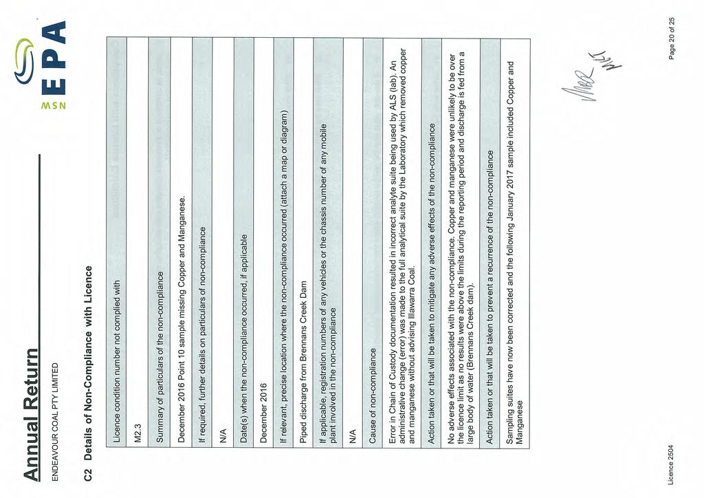
164
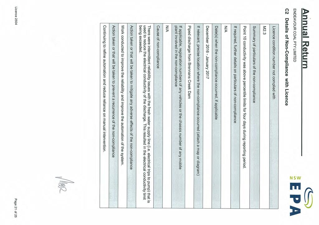
165
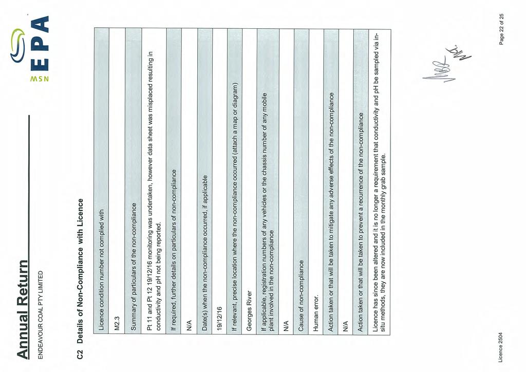
166

167
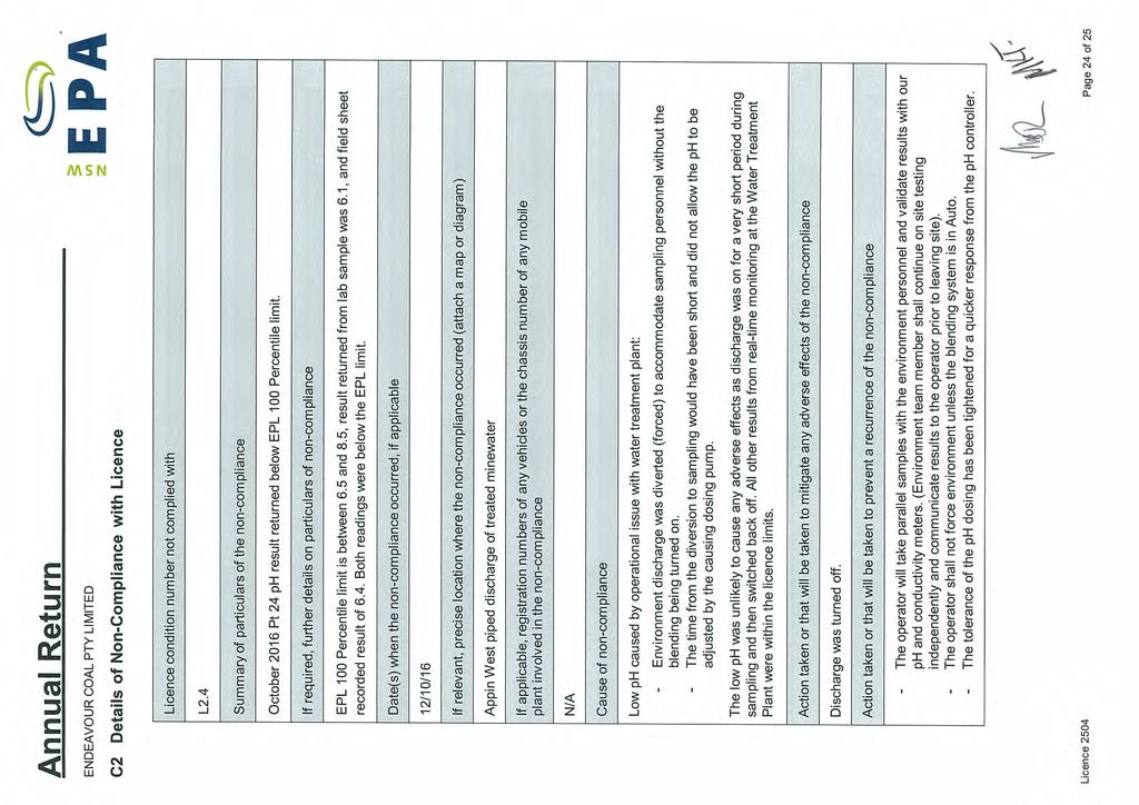
168
169
170
171
172
173

174
175 APPENDIX C: BSO COMMUNITY COMPLAINTS REPORT FY17 Annual Review FY

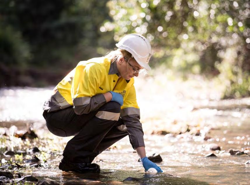

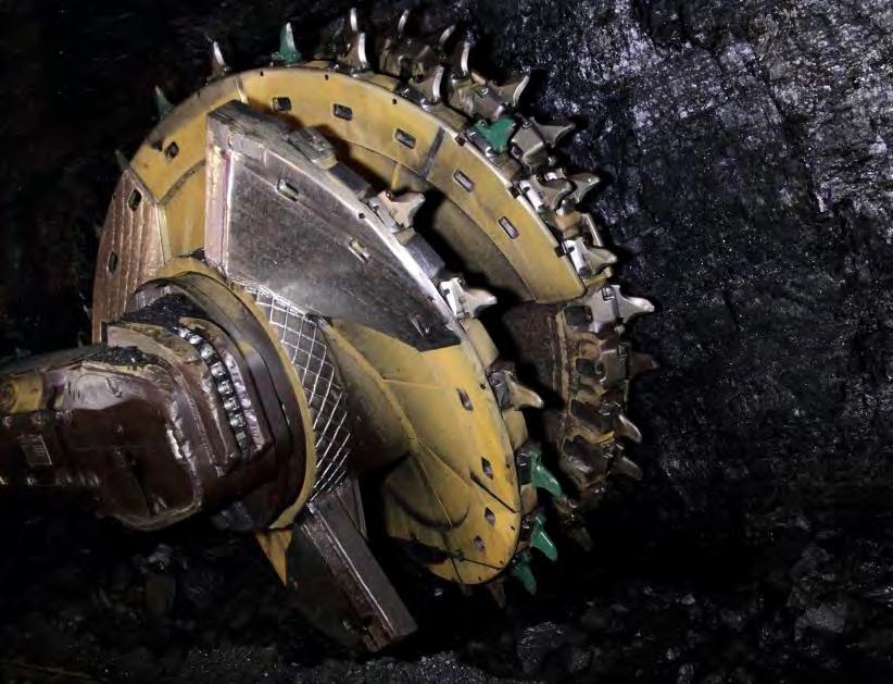

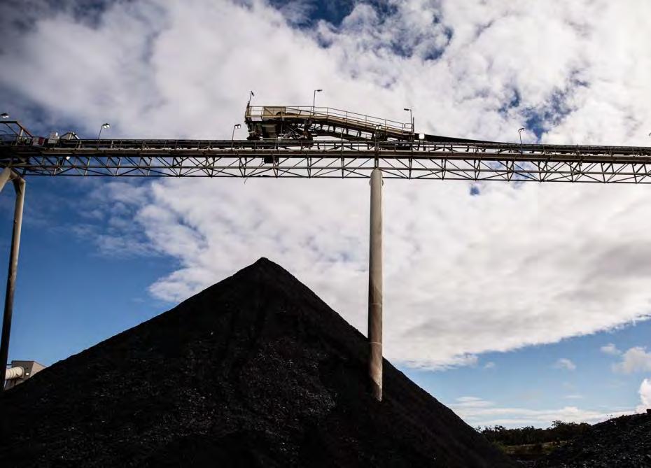
176 COMPLAINTS REPORT June 2017 BULLI SEAM OPERATIONS