GENERAL PLAN UPDATE. Joint Study Session April 13, 2017
|
|
|
- Kelly Fisher
- 5 years ago
- Views:
Transcription

1 GENERAL PLAN UPDATE Joint Study Session April 13, 2017
2 Interrelated Issues and Topics Property Owner Requests Mobility: Efficiency and Safety Land Use Plan (in the City) Light Rail/ Transit Jobs/ Housing Ratio Mobility: Vehicle Miles Traveled Annexation Strategy (outside the City) Vision and Supporting Principles Document Outline
3 Interrelated Issues and Topics Property Owner Requests Mobility: Efficiency and Safety Land Use Plan (in the City) Light Rail/ Transit Jobs/ Housing Ratio Mobility: Vehicle Miles Traveled Annexation Strategy (outside the City) Vision and Supporting Principles Document Outline

4 Last time Progress since last fall Land use categories Opportunity Site alternatives Property owner requests Infill policies General Plan outline Some discussion of jobs-tohousing ratio
")
5 Preferred Land Use Map (Attachment 1)
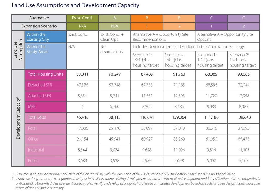
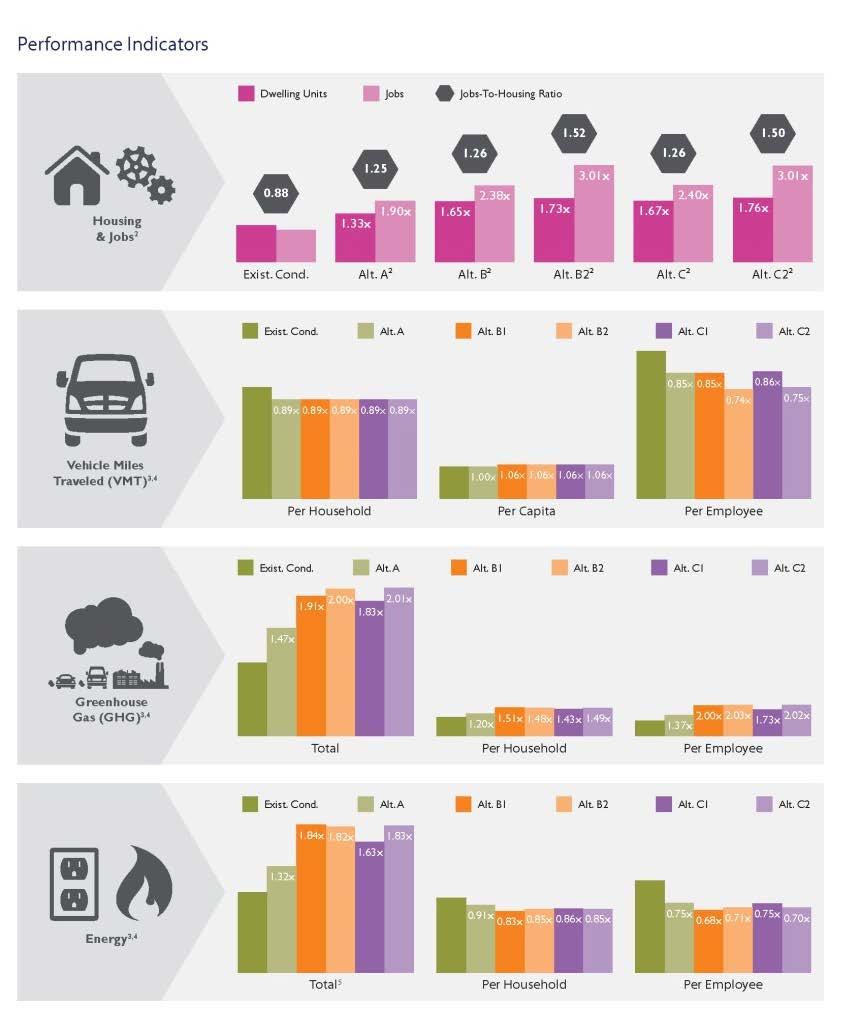
6 Performance Indicators (Attachment 2)
7 Jobs-Housing Ratio SACOG MTP: Jobs-Housing is dependent on the geography used there is no right geography Areas with good jobs-housing balance may still force workers to commute Regional target: 1.2:1 by % regional average increase between 2016 and 2036 Policy Direction Request #1: Provide direction on the preferred jobs/housing target for the General Plan For Elk Grove: J/H ratio today: 0.94:1 4% increase = 0.97:1

8 Annexation Strategy Study Areas Policy Direction Request #2A: Confirm that Study Area 4 should not be carried forward into the draft General Plan
 Land plan guidelines Land programming considerations")
9 Annexation Strategy (Attachment 3) Land use programs provide: General siting criteria (applicable to all study areas) Land plan guidelines Land programming considerations Performance standards
10 Annexation Strategy With changes to the Jobs-Housing target Policy Direction Request #2B What jobs-housing target will be included in the General Plan? Jobs-Housing target will affect the land use programs for the Study Areas. The draft in Attachment 3 still includes both the 1.2:1 ratio (Scenario 1) and the 1.4:1 ratio (Scenario 2). Staff has not prepared any additional scenarios.
11 Annexation Strategy With changes to the Jobs-Housing target Policy Direction Request #2C Will portions of the Study Areas be identified for continued agricultural use during the life of this General Plan? Scenario 1 provides a portion of the Study Areas with continued agricultural use; Scenario 2 does not. A future General Plan could modify these program components. Or, development opportunities (including how uses transition to the agricultural areas south of Eschinger Road) could be identified.
12 Annexation Strategy (Attachment 3) Policies and actions regarding annexations and future development: Support applications to LAFCo if: Implement the General Plan Located within Study Areas Work with Sacramento County: SOI amendments Master tax sharing, Fair-share allocation of regional housing needs Annexation proposals must: Generally be provided as a Specific Plan Demonstrate community benefit Policy Direction Request #2D: Confirm direction on the Annexation Strategy (policies and action items)
13 Annexation Strategy LAFCo Applications in Process Sports Complex SOI Amendment Applicant: City Location: Study Area 1 Kammerer/99 SOI Project Applicant: Private Party Location: Study Area 2 Bilby Ridge SOI Applicant: Private Party Location: Study Area 3


14 Annexation Strategy Active SOI Applications Kammerer/99 SOIA Land use information is required for SOI applications Sports Complex Bilby Ridge SOIA
 Policy")

15 Annexation Strategy Study Areas - Bubble Diagram examples (Attachment 3) Policy Direction Request #2E: Provide direction on preparation of conceptual land use diagrams

16 Annexation AKT Request for Study Area Policy Direction Request #2F: Provide direction on AKT Investments request Staff does not recommend inclusion: Outreach has already been conducted. Area not part of City s 2008 to 2013 SOI Application. Proposed density may conflict with adjoining development. Proposed uses would likely necessitate constructing infrastructure along Calvine Rd to Grant Line Rd conflicting with existing policies in the Rural Area. Would create pressure on the area to increase development density.
 i. Roadway performance targets ii. Roadway sizing diagram Why?")
17 Mobility Policies (Attachment 5) 1. Vehicle Miles Traveled (VMT) i. Proposed General Plan policies ii. Development review process and CEQA iii. Screening map and criteria 2. Roadway Efficiency (replaces LOS) i. Roadway performance targets ii. Roadway sizing diagram Why? VMT standards will replace LOS as a traffic impact metric in transportation and traffic CEQA analyses (SB 743) No new guidance from State to date Provides a balanced approach between implementing the pending CEQA changes and maintaining local land use authority
18 Mobility Policies Vehicle Miles Traveled (VMT) Key aspects of new proposed policies and procedures: Proposed General Plan Policies (Attachment 5B) VMT limits by land use designation (15% below a 2015 baseline) Citywide land use projects in accumulation and build-out cannot exceed baseline Study Area land use projects must achieve a VMT level 15% below the baseline VMT limits for transportation projects Short-term, not to exceed the project s baseline Long-term, consistent with regional plans Policy Direction Request #3A: Confirm direction on VMT analysis and thresholds is appropriate to move forward

19 Mobility Policies Pre-Screening Map (Attachment 5C) Shortens the process for many areas, if project is consistent with the Land Use Plan Pre-screened areas are shown in white and have been determined to result in 15% or below the average VMT/service population established for the land use designation if developed to the specifications of the Land Use Plan.
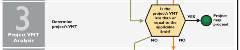
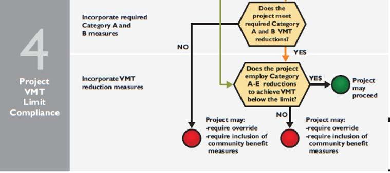
20 Mobility Policies Transportation Analysis Guidelines: Provides a 4-step process for calculating and determining VMT impacts VMT limits established by land use designation 5 VMT Reduction Categories: Outlines 5 types of strategies to reduce VMT within proposed projects Land Use Designation VMT Limit (Daily/SP) Community Commercial 69.2 Regional Commercial 40.9 Employment Center 11.9 Light Industrial/Flex 26.2 Light Industrial 42.2 Heavy Industrial 31.1 Village Center Mixed Use 27.2 Residential Mixed Use 17.5 Parks and Open Space 0 1 Resource Management 0 1 Public Services 20.0 Rural Residential 20.1 Estate Residential Low Density Residential 12.0 Medium Density Residential 10.9 High Density Residential 7.8 Agriculture 30.5 Notes: 1. These designations are not anticipated to produce substantial VMT and are exempt from analysis. Service Population = Residents + Employees


21 Mobility Policies VMT limits for land use projects:
22 Mobility Policies Roadway Efficiency and Safety Policy Roadway Performance Target (Attachment 5B) General Plan Policy: Robust and efficient roadway network Safe and convenient access Balanced with tangible and financial implications of roadway improvements Policy Direction Request #3B: Confirm direction on roadway efficiency and safety policy is appropriate to move forward Performance Targets 1. Intersections 2. Segments 3. Pedestrian and bicycle stress scores
23 Mobility Policies 3 Types of Performance Targets 1. Intersection Performance Targets 2. Segment Performance Targets 3. Pedestrian and Bicycle Performance Stress Scores Facility Type Arterial Expressway Freeway Number of Lanes Median Speed ADT Target 25 13, ,600 Intersection Control Peak Hour Delay 35 15,700 No 40 16,600 Design Target 45 17, ,600 2 [seconds/vehicle] 25 14, ,400 Stop 35 16,500 Yes < ,500 (Side-Street & All-Way) 45 18, ,600 Signal < , ,600 Roundabout 4 No < 35.1 Seek the lowest stress scores possible for pedestrian and bicycle performance after considering factors including design limitations and financial implications , , ,400 4 Yes 35 33, , ,200 5 Yes 45 45, ,400 6 Yes 35 48, , ,000 7 Yes 45 59,400 8 Yes 45 64, ,000 4 Yes 55 64,800 6 Yes 55 97,200 4 Yes ,400 6 Yes ,600 8 Yes ,800
24 Mobility Policies Roadway Sizing Diagram (Attachment 5D) Ultimate planned lane widths for arterials and collectors Maintains 2-lane roads in Sheldon Rural Area, including Bradshaw Road Policy Direction Request #3C: Provide direction on whether to incorporate Scenario 6 into the roadway sizing diagram Maintains 2-lane Elk Grove Blvd. in Old Town Road diets along select corridors to accommodate on-street bicycle and off-street trail improvements Analyzed multiple scenarios Staff recommends Scenario 6 Lane configurations in the Rural Area are all at two lanes consistent with Rural Roads Policy

25 Mobility Policies Roadway Sizing Diagram Scenario 6

26 Vision and Supporting Principles Revised Vision and Supporting Principles (Attachment 6) Policy Direction Request #4: Confirm recommended changes to the Vision and Supporting Principles Staff has reviewed the draft Vision and Principles and recommends minor adjustments
27 Staff will initiate CEQA process Next Steps Notice of Preparation for the Environmental Impact Report (EIR) May of 2017 Staff will begin constructing the General Plan document template and narrative content Draft Plan and EIR available Summer 2017
28 GENERAL PLAN UPDATE Joint Study Session April 13, 2017