How to avoid getting bogged down by the Nova Scotia Wetland Conservation Policy
|
|
|
- Bertina Washington
- 5 years ago
- Views:
Transcription
1 How to avoid getting bogged down by the Nova Scotia Wetland Conservation Policy for the Environmental Services Association of Nova Scotia By Krista Hilchey Wetland Specialist, Nova Scotia Environment

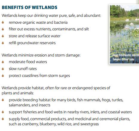
2 To manage human activity in or near wetlands, with the goal of no loss in Wetlands of Special Significance and the goal of preventing net loss in area and function for other wetlands To promote wetland protection and stewardship and to increase awareness of the importance of wetlands in the landscape To promote a long-term net gain in wetland types that have experienced high historic losses, in order to restore beneficial ecosystem services and functions across the province To encourage the use of buffers to better ensure the integrity of wetlands adjacent to development (i.e. residential, commercial, industrial) and agricultural, mining and forestry operations.

3 As defined by the Environment Act, a wetland in Nova Scotia is land commonly referred to as a marsh, swamp, fen or bog that: either periodically or permanently has a water table at, near or above the land s surface, or that is saturated with water; and sustains aquatic processes as indicated by the presence of poorly drained soils; and hydrophytic vegetation, and biological activities adapted to wet conditions.


4
5 Environmental Goals and Sustainable Prosperity Act The Province s environmental and economic goals are to ensure: n) a policy of preventing net loss of wetlands will be established by the year Environment Act Gives Nova Scotia Environment (NSE) ministerial authority over wetlands Activities Designation regulations- Section 5 Altering any of the following, or the flow of water in any of the following, is designated as an activity that requires an approval, unless it requires a notification under Section 5B or is exempt under Section 5D: a) a watercourse; b) a water resource; c) a wetland. Environmental Assessment regulations Class I Undertaking: An undertaking that disrupts a total of 2 ha or more of any wetland. Sustainability and Applied Science Division, Protected Areas and Ecosystems Branch, Wetland Specialist Compliance Division, Inspector Specialist Policy Division, Environmental Assessment Officer
6 Is a wetland present? Does a wetland policy no Is it a wetland of special exemption apply? significance (WSS)? No application required Is the alteration >2 ha of any wetland or wetland complex*? no Does the project perform a necessary public function? A preliminary project review is required. The applicant must write a letter to the Director of Protected Areas and Wetlands, describing the project and indicating how the project fulfills a necessary public function. no Standard Application Refer to Environmental Assessment process An application to alter will not be approved
7 An approval is NOT required for altering: wetlands on federal lands (these are managed under the Federal Policy on Wetland Conservation); wetlands less than 100 square metres in total area; wetlands constructed specifically for wastewater or stormwater treatment; wetlands created by humans on upland habitats not for the purpose of fulfilling compensation requirements under Wetland Alteration Approvals (e.g., excavated ponds); wetlands designated as Marshlands under the Agricultural Marshland Conservation Act as agricultural land; wetlands within agricultural drainage ditches; wetlands that develop as the unintended result of urban, commercial, industrial or agricultural construction projects completed less than 20 years before the current calendar year. a wetland for the purpose of linear developments that are less than 10m wide and less than 600 square metres in total area (such as forest access roads, secondary roads, and driveways) through shrub or wooded swamps that are not classified as Wetlands of Special Significance. Proponents are expected to maintain flow under the road by employing best management practices; a wetland for the purpose of maintenance for public safety or protection of adjacent properties and infrastructure in wetlands that develop within the medians or drainage ditches of transportation corridors or within the footprint of existing utility corridors or electrical generation, transmission and distribution infrastructure; a wetland for the purpose of harvesting trees or mowing agricultural fields in a wetland (best management practices should always be used to minimize damage).
8 Is a wetland present? Does a wetland policy no Is it a wetland of special exemption apply? significance (WSS)? No application required Is the alteration >2 ha of any wetland or wetland complex*? no Does the project perform a necessary public function? A preliminary project review is required. The applicant must write a letter to the Director of Protected Areas and Wetlands, describing the project and indicating how the project fulfills a necessary public function. no Standard Application Refer to Environmental Assessment process An application to alter will not be approved

9
10 Is a wetland present? Does a wetland policy no Is it a wetland of special exemption apply? significance (WSS)? No application required Necessary Public Function - Projects that provide public function on a provincial scale such as public transportation projects, public infrastructure, linear pipeline or transportation corridors, or electrical supply infrastructure, and projects necessary for public safety and protection of adjacent properties and infrastructure, and land transactions authorized through an Order of Executive Council. Is the alteration >2 ha of any wetland or wetland complex*? no Does the project perform a necessary public function? A preliminary project review is required. The applicant must write a letter to the Director of Protected Areas and Wetlands, describing the project and indicating how the project fulfills a necessary public function. no Standard Application Refer to Environmental Assessment process An application to alter will not be approved
11 Is a wetland present? Does a wetland policy no Is it a wetland of special exemption apply? significance (WSS)? No application required Is the alteration > 2 ha of any wetland or wetland complex*? no Does the project perform a necessary public function? A preliminary project review is required. The applicant must write a letter to the Director of Protected Areas and Wetlands, describing the project and indicating how the project fulfills a necessary public function. no Standard Application Refer to Environmental Assessment process An application to alter will not be approved *A wetland complex is comprised of all wetlands, of any size, connected by obvious water flows with the maximum distance being no more than 750 meters between wetland units. Wetlands will not be complexed across watershed boundaries unless necessary based on significant functional importance. The upland areas between wetland units must be predominately vegetated with shrubs and trees and there should be no significant barriers to wildlife movement between wetland units identified with a single wetland complex.
12 Standard Application: Components Administrative Information Description of the project and alteration Description of minimization and mitigation of impacts Wetland Boundary Delineation Wetland Functional Assessment Monitoring Plan* if required Compensation Plan Proof of ownership/agreement to conduct the activity on the site or has the legal right and ability to conduct the activity without the consent of the landowner or occupier. Proof of current registration with the Nova Scotia Registrar of Joint Stocks, if applicable, or another type of business registration from another province/territory or federal government. For projects on Crown land, an Integrated Resource Management approval from Nova Scotia Department of Natural Resources. Name and contact information for the applicant and application contact (if different from applicant) If applicable, name, address and signature of the Company President/Chief Executive Officer Property information (address, community, county, PID#)
13 Standard Application: Components Administrative Information Description of the project and alteration Description of minimization and mitigation of impacts Wetland Boundary Delineation Wetland Functional Assessment Monitoring Plan* if required Compensation Plan A site plan showing the location of project components relative to wetland boundaries (see boundary delineation). The main reason for the alteration, including the benefits to be derived from the project.
14 Standard Application: Components Administrative Information Description of the project and alteration Description of minimization and mitigation of impacts Wetland Boundary Delineation Wetland Functional Assessment Monitoring Plan* if required Compensation Plan Engineering approaches incorporated into the project design to mitigate anticipated water management issues that may arise from the wetland alteration; How the proposed design and methods minimize the size of the alteration required and minimize impacts to the wetland for projects where the entire wetland is not altered; Best management practices that will be used to minimize the impacts of specific activities associated with the project (e.g., sedimentation and erosion control).

15 Standard Application: Components Administrative Information Description of the project and alteration Description of minimization and mitigation of impacts Wetland Boundary Delineation Wetland Functional Assessment Monitoring Plan* if required Compensation Plan
16 Wetland Boundary Delineation Information This section should include: description of the methodologies used (e.g., U.S. Army Corp of Engineers approach); credentials of wetland delineator(s) performing the wetland boundary delineation; fine-scale maps or aerial photos (at a 1:5,000 or finer scale) that encompass the project area and include the delineated boundaries of the entire wetland (boundaries immediately adjacent to the project footprint must be identified and flagged on ground with at least 5 m accuracy; remaining boundaries may be based on either additional ground-truthing or desktop estimation from recent aerial photos); field data forms for each wetland delineated ( and, (optional) GIS ready shape files of wetland boundaries Note: It is expected that delineation will be conducted during growing season (approximately June 1 to September 30). Delineations undertaken between April 1 - June 1, or September 30 November 30 may be acceptable, but should be discussed with the NSE Wetland Specialist and Inspector prior to undertaking the assessment.

17 Standard Application: Components Administrative Information Description of the project and alteration Description of minimization and mitigation of impacts Wetland Boundary Delineation Wetland Functional Assessment Monitoring Plan* if required Compensation Plan
18 Functional Assessment Information Applicants are expected to use the Nova Scotia Wetland Assessment Method (NovaWET). Comparable approaches may be acceptable, but should be agreed upon in consultation with the NSE Wetland Specialist and Inspector prior to beginning the assessment. This section should include: description of the methodologies used (only required if using an approach other than NovaWET); credentials of wetland assessor(s) performing the functional assessment; summary of any red-highlighted significant functions (SF); any necessary maps, photographs, diagrams, descriptions or other materials needed to demonstrate the results of the functional assessment; listing of any additional resources used to provide the assessment (e.g. Atlantic Canada Conservation Data Centre ACCDC reports, etc.); and, NovaWET data sheets for each wetland ( Note: It is expected that the functional assessment will be conducted during growing season (approximately June 1 to September 30). Functional assessments conducted outside this period may be acceptable, but should be confirmed with the NSE Wetland Specialist and Inspector prior to undertaking the assessment.
19 Standard Application: Components Administrative Information Description of the project and alteration Description of minimization and mitigation of impacts Wetland Boundary Delineation Wetland Functional Assessment Monitoring Plan* if required Compensation Plan
20 Monitoring Plan Information o How baseline conditions will be documented before construction begins. o How changes in hydrology (especially under roads) will be monitored, generally through the use of shallow wells. Please provide proposed performance indicators. o How changes in the vegetation community will be monitored, especially regarding the proportion of FACW, OBL, and invasive species. Please provide proposed performance indicators. o How changes in water quality/turbidity will be monitored, especially after large rain events. Please provide proposed performance indicators. o Monitoring should be completed for: pre-alteration, Year 1, and Year 2. Monitoring reports should be sent to NSE. If agreed-upon performance measures have been met after Year 2, only photos (not a full suite of monitoring) to ensure everything is still on track are required annually until Year 5. Monitoring reports should be sent to NSE for Year 5. If agreed-upon performance measures have not been met after Year 2, annual monitoring will still be required up to and including Year 5. o All aspects of the monitoring plan should be approved by NSE (including proposed performance indicators).


21 Standard Application: Components Administrative Information Description of the project and alteration Description of minimization and mitigation of impacts Wetland Boundary Delineation Wetland Functional Assessment Monitoring Plan* if required Compensation Plan

22