Legislative Water Commission April 23, Jim Stark, Director Straight River, Becker County
|
|
|
- Sharlene Berry
- 5 years ago
- Views:
Transcription

1 Legislative Water Commission April 23, 2018 Co-chairs: Senator Wiger Representative Torkelson Jim Stark, Director Straight River, Becker County 1
2 Agenda Approve minutes -- March 26 Geologic atlas program Clean Water Fund: performance report 2018 LWC recommendations 2019 LWC process Summer tour Updates on water legislation Next meetings: June 19

3 Issue Presentation: Geologic Atlas Program Dale Setterholm Minnesota Geological Survey Paul Putzier DNR Ray Wuolo- Barr Engineering
4 County Geologic Atlas Program Dale Setterholm Minnesota Geological Survey University of Minnesota
5 Foundational information essential to water management: Geology determines: Where can we obtain water? Aquifer depths and boundaries Connections from the land surface to aquifers (recharge) Connections from aquifers to the land surface (discharge) or surface water bodies Who shares an aquifer (database of wells)? Composition and age of ground water in aquifer systems
6 Information used in water management at all levels: To support: water appropriation decisions (DNR) wellhead protection plans and well construction practices (MDH) meaningful monitoring (multiple parties) spill response and design of remediation (MPCA) groundwater models (Met Council, DNR, others) permit decisions (including local government) land use planning mineral resource management
7 Information used by cities, counties, businesses, and citizens What aquifers are available to me, how deep? Where is our water most vulnerable? User s Guide to Geologic Atlases- nontechnical explanation especially helpful to decision-makers Maps and databases available in digital or paper formats Information that does not lose value over time A framework for more detailed investigations

8
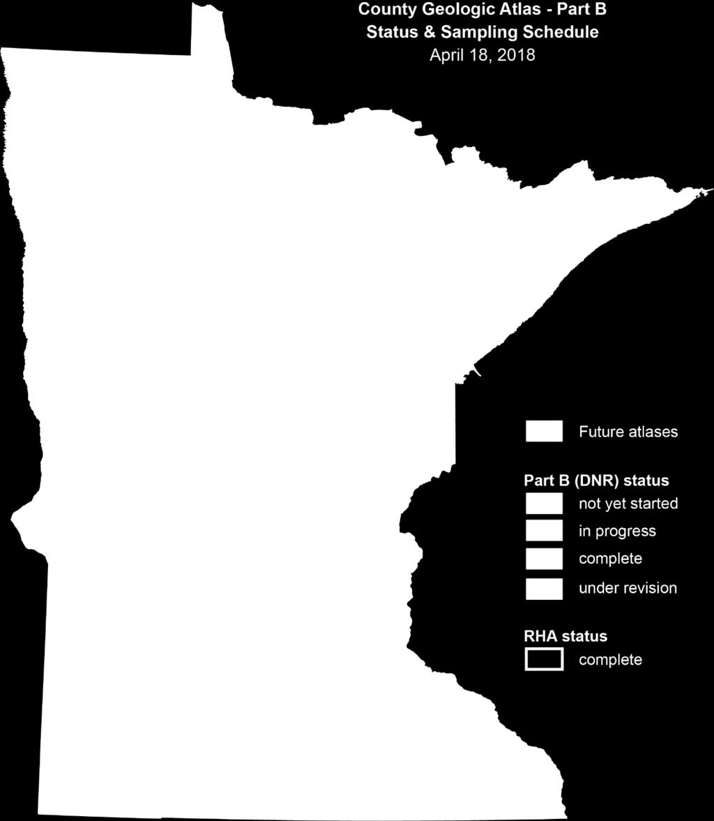
9 Program Status Striving for 4 or 5 completed counties per year (each project takes 3 to 4 years) Part A requires about $2.1 million/year MGS relies on funding from LCCMR, CWF, DNR contract, federal costsharing, and in-kind service from counties. Projected to finish statewide coverage about 2026.
10

11


12 April 2018 County Geologic Atlas Program 12
13 Who Uses the County Geologic Atlas? Private Citizens Business & Industry Agriculture Environmental Consultants Counties County Planning Commission/Planning Staff, Water Plan Task Force, Environmental Services Department staff, Public Works, County Engineer Soil Water Conservation District (SWCD) & County Conservation Districts (CD) Cities SWCD Managers, Technical Service staff, Watershed Project Managers Planning Commission/Planning Staff, City Engineering Staff, Public Works Staff Waterworks Townships Township Board of Supervisors, Township Planning Commission State & Federal Agencies MPCA, MNDOT, MDA, MDH, BWSR, USGS 13


14 How are the County Geologic Atlases Being Used? County Projects Jerry Spetzman, Administrator Chisago Lakes-Lake Improvement District, Chisago County Chisago County uses the County Atlas to help inform land use policy decisions. Specific examples include: the Pollution Sensitivity of Near- Surface Materials map was used to help determine the location of a natural burial cemetery; the Bedrock Geology map was used to determine if sufficient quantities of ground water was available to cool a natural gas power plant; the sand distribution model was used to inform frac sand mining policy. The maps (in the Atlas) provide an abundance of useful information. The map layers have been added to the Chisago County website as part of the interactive GIS map and are available for public use. Geothermal & Agricultural Projects Rob Vix, Drilling Manager, Traut Companies, Inc. For agriculture projects the atlas helps when looking for potential high capacity wells or difficult sites by giving us some ideas of how much unconsolidated geology is available. I use digital copies of the county atlas on a regular basis. The county atlas maps provides some idea of how feasible a geothermal project is. 14


15 How are the County Geologic Atlases Being Used? Consulting Hydrogeologist Kristi Anderson, Hydrogeologist, Northwest AqwaTek Solutions The majority of what I do is working with the agricultural community on water appropriation permits for crop irrigation systems; which are critical to successful farming in Minnesota. I typically look to the County Geologic Atlas (CGA).as the starting point in my work. County Projects Amanda Guertin, Benton SWCD Water Plan Technician, Benton County. I have been using the Atlas pretty frequently. After the Atlas was released we created a Sensitive Areas Management Plan (SAMP) to identify sensitive areas of the County that should be protected from development or disturbance due to critical, vulnerable, or rare water resources. The SAMP overlays the County Atlas data to create a map showing the degree of sensitivity throughout the County. Our office uses this plan, along with the Water Plan extensively to guide our focus for project implementation and the County Department of Development also uses the plans regularly. 15

16

17 Recharge Zone Hydrogeologic Cross-Section

18 Pollution Sensitivity of the cse aquifer
19 Water Balance Water In = Water Out Evapotranspiration Rainfall Evaporation Runoff water table Runoff Groundwater flow
20 Water Balance Key to Understanding Water Sustainability Evapotranspiration Rainfall Evaporation water table X Groundwater flow
21 Rainfall/Snow runoff evapotranspiration runoff Geology is important BUT it only one part of the puzzle infiltration (Recharge to Groundwater) stream baseflow The groundwater container Geology, Groundwater Levels
")
22 Clean Water Fund Performance Mississippi River at Clearwater, MN (September 2012)

23 CWF FY Funding Implementation: $105 M Planning/Tech Assist. $67 M Monitoring/Mapping/Data: $41 M Research/Evaluation $8 M Total: $221 M/biennium Emphasis on impaired water Entire state assessed Focus on local implementation
24 CWF Goals and Expectations Lake Quality: + 7-8% Acceptable Lake Tropic Status: from 62% to 70% Rivers: Fish IBI: from 60% to 67% Wells-arsenic standard: (reduce by 50%) Wells: nitrate standard (reduce by 20 %) GW declines (less than 10% declining)
25 Progress and Citizen Expectations Improvements seem small? Lag-time External drivers: (land use, climate, economy, trade, population) 2034 is coming/citizen expectations Can outcomes be improved? Can LWC support additional change?


26 Minnesota s Water Quality Improvement Goal #25by25MN Katie Pratt Director of Communications and Public Engagement katie.pratt@state.mn.us

27 Citizens Said: + Education and engagement + Water retention + More GOV/public involvement + Local planning Focus on drinking water Reduce salt Inadequate septic systems Focus funding Focus on incentives


28 2019 Focus for the LWC Recommendations-2018 From a sustainability perspective, a key point is that decisions today may not be fully realized for many years
29 Alternatives for WWTPs Peer review of waste-water standards Promote WWTP efficiency/alternatives PFA Bonding request $167M
30 Agenda: Discussion LWC Process 30

31 2019 LWC Recommendation Discussion Water trading- Storm water for wastewater Water for the future Water retention Private wells Public drinking water Evaluate past BMPs Evaluate water management Many more..
32 Schedule 2019? Issues with narratives: April LWC Consensus--top 3: after session (short and long term issues) Expert input: summer Recommendation by issue: Fall Recommendation consensus: Fall Document to support legislation: (December)

33 Discussion: LWC summer issue tour - One day? - Select an issue: * Water retention/infiltration * Lakes with problems * Drinking water * Groundwater/surface water * Others? Poll LAs for possible dates Watch for 33

34 Updates on Water Legislation Announcements: Water Day at the Capitol

35 Thanks The well was dry beside the door, And so we went with pail and can Across the fields behind the house To seek the brook if it still ran. Going for Water -- Robert Frost