Pilot Projects for a National Ground Water Monitoring Network
|
|
|
- Madison Davidson
- 5 years ago
- Views:
Transcription
")
1 Pilot Projects for a National Ground Water Monitoring Network Daryll Pope U.S. Geological Survey, New Jersey WSC 2010 Ground Water Protection Council (GWPC) Water/Energy Symposium
2 Presentation Outline ACWI, NGWMN, and Pilot Projects Pilot Tasks Pilot States and Principal/Major Aquifers Data Portal

3 Overall goal to develop and encourage implementation of a nationwide, long term ground-water quantity and quality monitoring framework National Groundwater Monitoring Network (NGWMN) NGWMN is designed to provide information necessary for planning, management, and development of groundwater supplies To meet current and future water-supply and ecosystem requirements Based on Principal aquifers ACWI Subcommittee on Groundwater
4 Pilot Projects Purpose is to test the concepts and produce information to evaluate the costs and technical feasibility of the NGWMN Lessons learned will be used to improve the Framework Document of the NGWMN Use this information in the Implementation Phase of the National Ground Water Monitoring Network Five pilots were selected Pilots are volunteers Monthly conference calls to discuss issues, progress

5 National Ground Water Monitoring Network Pilot Projects

6 Pilot Timeline


7 Pilot Tasks: Network Evaluation Evaluate potential monitoring points within each principal, major or other important aquifer for potential inclusion in the NGWMN Most pilots complete with this task

8 Pilot Tasks: Unstressed/Targeted Flag all or a subset of proposed monitoring points as meeting NGWMN s targeted or unstressed subnetwork design criteria Several approaches are being used. targeted unstressed

9 Pilot Tasks: Data Gaps Identify data gaps Spatial Well characteristics Frequency of waterlevel measurement Frequency of sampling Analyte lists Have identified gaps in all areas above


10 Pilot Tasks: Field Practices Field Practices Determine whether the data provider s field practices meet NGWMN criteria and what changes may be required Evaluate documentation of field procedures Most differences found have been minor

11 Pilot Tasks: Data Management Data Management Determine whether the data management standards meet the NGWMN criteria Evaluate databases in comparison to the minimum data elements Data management practice differences have been minor Evaluate ability to interface with a NGWMN data portal Working on this issue now. Several states have web services already available.
12 Pilot Tasks: Cost Estimates Identify Ballpark Costs for: Pilot participation Operation and management of NGWMN wells Interface with data portal Capital and O&M needed to fill data gaps Spatial gaps, by aquifer Temporal gaps in water-level measurement and water-quality sampling Analyte gaps October meetings will focus on this
13 Pilot Tasks: Pilot Report Pilots will complete a report on their work by December A report template/outline was provided to the Pilots this spring Most pilots have begun working on writing sections of the report. We have been discussing issues at our monthly calls

14 Montana Primary Agency Montana Bureau of Mines and Geology Statewide Principal Aquifers Sand and gravel aquifers Lower Tertiary, Northern Rocky Mountains Intermontane Basins, Pacific Northwest basaltic rock, Upper Cretaceous, Lower Cretaceous, Paleozoic aquifer systems Highlights Cross-sections through intermontane basins from Recharge-discharge Planning on setting up web services to provide data to the Portal
 Texas Commission on Env.")
15 Texas Principal/Major Aquifers Edwards-Trinity aquifer system, Seymour aquifer, Blaine aquifer, Pecos River Basin alluvial aquifer, Coastal lowlands aquifer system, Texas coastal uplands aquifer system, Rio Grande aquifer system Primary Agencies Texas Water Development Board (TWDB) Texas Commission on Env. Quality Highlights Working through aquifers to select wells and flagging as unstressed/targeted. Few data gaps because of large pool of candidate wells. WL trend network is composed on continuous recorder sites. Rest are surveillance

16 Minnesota Primary Agencies Minnesota DNR Minnesota Pollution Control Agency Principal/Major Aquifers Focus on Cambrian-Ordovician aquifer system Principal aquifer Upper Ordovician aquifers Prarie du Chien-Jordan aquifers Tunnel City/Wonewoc aquifers Mt. Simon aquifer Highlights Used wells from existing network that met criteria. Focused on one aquifer system Data gaps related to Shallow/deep aquifers Raised some questions early about shallow irrigation wells that affect water levels seasonally, but not in the long term

17 Illinois-Indiana Major/Principal Aquifers Sand and Gravel aquifers Mahomet-Teays Primary Agencies Illinois State Water Survey Illinois State Geological Survey Indiana Department of Natural Resources, Division of Water USGS offices in IL and IN Highlights Monitoring Point Selection Are building a new network in this process Multi-state, multi-agency Data from a variety of sources Public supply wells being considered for water-quality network

18 New Jersey Primary Agencies New Jersey Geological Survey USGS NJ Water Science Center Statewide Principal/Major Aquifers Northern Atlantic Coastal Plain, 10 major subunits Early Mesozoic Basin, Piedmont and Blue Ridge crystalline rock, Piedmont and Blue Ridge carbonate rock Highlights Water level trend and surveillance networks. Water-quality surveillance networks. Chloride, Shallow GW Public supply wells for WL surveillance network Sampling frequency on surveillance networks Water-level and water-quality data, and main site data are available through web services
19 Overall issues Most pilots are working on Water levels first Categorizing wells as Targeted/unstressed is proceeding. Several different approaches used Waiting to see how pilots address water-quality unstressed/targeted Sampling frequency for water-level and Water-quality surveillance networks Baseline periods for surveillance networks Use of Public supply wells Major/Regional aquifers Privacy information
20 Pilot Data Portal Design underway at the USGS Center for Integrated Data Analytics in Madison, WI Portal will be a new system, designed with knowledge of the data exchange standards used by: The EPA/USGS Water Quality Data Exchange (a STORET and NWIS Data Portal) The Open Geospatial Consortium and associated Groundwater Interoperability Experiment (USGS, NRCan, CSIRO, and CUAHSI) Goal is automated data transfer from data providers, through portal, to public user. Intermediate approach may be needed

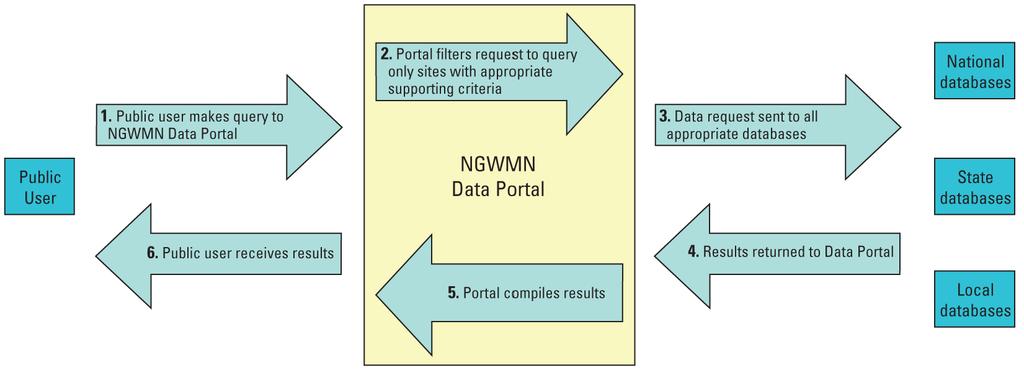
21 DATA PORTAL

22

23 Water-level Trend network

24 Water-level Trend network
25 Water-quality Surveillance Network in NACP, Stressed