SEA STATEMENT BALLAGHADERREEN LOCAL AREA PLAN STRATEGIC ENVIRONMENTAL ASSESSMENT. Roscommon County Council. CAAS Ltd. JULY 2017.
|
|
|
- Branden Charles
- 5 years ago
- Views:
Transcription


1 SEA STATEMENT FOR THE BALLAGHADERREEN LOCAL AREA PLAN STRATEGIC ENVIRONMENTAL ASSESSMENT for: Roscommon County Council The Courthouse Roscommon County Roscommon by: CAAS Ltd. 1 st Floor Ormond Quay Upper Dublin 7 D07 DAV 9 JULY 2017 Includes Ordnance Survey Ireland data reproduced under OSi Licence Number 2010/18/CCMAI Roscommon County Council. Unauthorised reproduction infringes Ordnance Survey Ireland and Government of Ireland copyright. Ordnance Survey Ireland
2 Table of Contents Section 1 Introduction Terms of Reference SEA Definition and Legislation Content of the SEA Statement Implications of SEA for the Plan... 1 Section 2 How Environmental Considerations were integrated into the Plan Introduction Consultations Communication of environmental sensitivities Integration of Environmental Considerations into the text of the Plan... 3 Section 3 Environmental Report and Submissions & Observations Introduction SEA Scoping Submissions Submissions on the Draft Plan and Environmental Report Environmental Report Section 4 Alternatives and the Plan Introduction Description of the Development Strategies Evaluation of Alternatives The Selected Alternative Development Strategy for the Plan Section 5 Monitoring Measures Introduction Indicators and Targets Sources Reporting Thresholds CAAS for Roscommon County Council i
3 Section 1 Introduction 1.1 Terms of Reference This is the SEA Statement for the Ballaghaderreen Local Area Plan (LAP) Strategic Environmental Assessment (SEA). 1.2 SEA Definition and Legislation SEA is a systematic process of predicting and evaluating the likely environmental effects of implementing a plan, or other strategic action, in order to ensure that these effects are appropriately addressed at the earliest appropriate stage of decision-making on a par with economic and social considerations. Directive 2001/42/EC of the European Parliament and of the Council, of 27 June 2001, on the assessment of the effects of certain plans and programmes on the environment, referred to hereafter as the SEA Directive, introduced the requirement that SEA be carried out on plans and programmes which are prepared for a number of sectors, including land use planning. The SEA Directive was transposed into Irish Law through the European Communities (Environmental Assessment of Certain Plans and Programmes) Regulations 2004 (Statutory Instrument Number (SI No. 435 of 2004) and the Planning and Development (SEA) Regulations 2004 (SI No. 436 of 2004). Both sets of Regulations became operational on 21 July The Regulations have been amended by the European Communities (Environmental Assessment of Certain Plans and Programmes) (Amendment) Regulations 2011 (SI No. 200 of 2011) and the Planning and Development (SEA) (Amendment) Regulations 2011 (SI No. 201 of 2011). The Planning and Development (SEA) Regulations 2004, as amended, require that SEA is undertaken for the preparation of certain LAPs. Where SEA is undertaken, the Regulations require that a Statement is made available to the public and the competent environmental authorities after the adoption of a LAP. This Statement is referred to as an SEA Statement Content of the SEA Statement The SEA Statement is required to include information summarising: a) how environmental considerations have been integrated into the Plan; b) how the following have been taken into account during the preparation of the Plan: the environmental report, submissions and observations made to the planning authority on the Draft Plan and Environmental Report, and any transboundary consultations [this is not relevant to this SEA] c) the reasons for choosing the Plan in the light of the other reasonable alternatives dealt with; and d) the measures decided upon to monitor the significant environmental effects of implementation of the Plan. 1.4 Implications of SEA for the Plan As the LAP was determined to have the potential to result in significant environmental effects, if unmitigated, including those relating to elevated levels of flood risk at certain areas within the town area, SEA is required to be undertaken on the Plan. The findings of the SEA are expressed in the Environmental Report. Elected Members of Roscommon County Council took account of the findings of this report and other related SEA output during their consideration of the Draft Plan and before its adoption. 1 Department of Environment, Heritage and Local Government (2004) Implementation of SEA Directive (2001/42/EC): Guidelines for Regional Authorities and Planning Authorities, Dublin: Government of Ireland. CAAS for Roscommon County Council 1
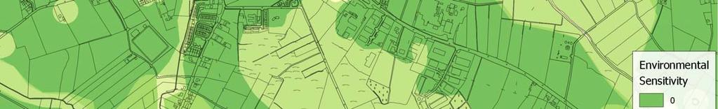
4 Section 2 How Environmental Considerations were integrated into the Plan 2.1 Introduction Environmental considerations were integrated into the Plan through: Consultations with environmental authorities; Communication of environmental sensitivities through the SEA and associated Appropriate Assessment (AA) and Strategic Flood Risk Assessment (SFRA); and Integration of individual SEA, AA and SFRA provisions into the text of the Plan. 2.2 Consultations As environmental authorities identified under the Planning and Development (SEA) Regulations, as amended, the following authorities were sent SEA scoping notices indicating that submissions or observations in relation to the scope and level of detail of the information to be included in the environmental report could be made to the Council: Environmental Protection Agency, Department of Communications, Climate Action and Environment, Department of Agriculture, Food and the Marine, Department of Housing, Planning, Community and Local Government, Community and Local Government, Department of Arts, Heritage, Regional, Rural and Gaeltacht Affairs, Galway County Council, Leitrim County Council, Longford County Council, Mayo County Council, Offaly County Council, Sligo County Council and Westmeath County Council. Two submissions on the scope of the SEA were received and these were taken into account during the formulation of the scope of the SEA. Further detail on these submissions is provided under Section 3.2. In addition, submissions were made on the Draft Plan and SEA Environmental Report while they were on public display (see Section 3.3). 2.3 Communication of environmental sensitivities Overview Environmental considerations were integrated into the Draft Plan both text and zoning before it was placed on public display. The sensitivities considered by the SEA, AA and SFRA within the town and in the wider region include the following: European Sites (Natura 2000); Natural Heritage Areas and proposed Natural Heritage Areas; CORINE Land Cover Data; Soil Type; Water Framework Directive Surface Water and Groundwater Status; Aquifer Vulnerability; WFD Entries to Registers of Protected Areas; Flood Risk Zones; Wastewater Treatment capacity and demand; Drinking water supply and quality; Archaeological Heritage; Architectural Heritage; and Landscape Character Areas. A number of these sensitivities are mapped on Figure 2.1, Figure 2.2 and Figure 2.3. In order to identify where most sensitivities within the town occur, a number of the environmental sensitivities listed above were weighted and mapped overlapping each other. Figure 2.3 provides an overlay of environmental sensitivities for the town. The occurrence of multiple sensitivities in any location does not preclude development; rather it flags at a strategic level that the mitigation measures - which have already been integrated into the Plan as policies and objectives - will need to be complied with in order to ensure that the implementation of the Plan contributes towards environmental protection. CAAS for Roscommon County Council 2
5 The overlay clearly shows the robustness of the environment in the town. The majority of areas are shown to be of a low vulnerability. The most sensitive areas within the Town are located along surface waters, at sensitive land covers and at cultural heritage designations Appropriate Assessment the potential significant effects of implementing the Plan, if unmitigated. The measures generally benefit multiple environmental components i.e. a measure providing for the protection of biodiversity, flora and fauna could beneficially impact upon the minimisation of flood risk and the protection of human health, for example. An Appropriate Assessment (AA) Screening has been undertaken alongside the preparation of the Plan. The requirement for AA is provided under the EU Habitats Directive (Directive 1992/43/EEC). The AA Screening concluded that the Plan will not affect the integrity of the Natura 2000 network, consequently further stages of AA were not required. The preparation of the Plan, SEA and AA has taken place concurrently and the findings of the AA have informed both the Plan and the SEA. Recommendations made by the AA were integrated into the Plan Strategic Flood Risk Assessment A Strategic Flood Risk Assessment (SFRA) has been undertaken alongside the preparation of the Plan. The requirement for SFRA is provided under The Planning System and Flood Risk Management Guidelines for Planning Authorities (DEHLG, 2009). The preparation of the Plan, SEA and SFRA has taken place concurrently and the findings of the SFRA have informed both the Plan and the SEA. Various recommendations made by the SFRA have been integrated into the Plan and the land use zoning contained in the Plan has been informed by flood risk sensitivities. 2.4 Integration of Environmental Considerations into the text of the Plan All recommendations made by the SEA, AA and SFRA processes were integrated into the Plan. Table 2.1 links key mitigation measure(s) - which have been integrated into the Plan - to CAAS for Roscommon County Council 3

6 Figure 2.1 Selection of Environmental Sensitivities (Set 1 of 2) CAAS for Roscommon County Council 4

7 Figure 2.2 Selection of Environmental Sensitivities (Set 2 of 2) CAAS for Roscommon County Council 5


8 Figure 2.3 Overlay of Environmental Sensitivities CAAS for Roscommon County Council (2017) CAAS for Roscommon County Council 6
9 Table 2.1 Mitigation Measures SEA Statement for the Ballaghaderreen Local Area Plan Strategic Environmental Assessment Topic Biodiversity and flora and fauna Potentially Significant Adverse Effect, if Unmitigated Loss of biodiversity with regard to designated biodiversity and flora and fauna, ecological connectivity and non-designated biodiversity and flora and fauna Mitigation, including Strategic Aim No. 7: Recognise that archaeological, natural and built heritage in the area are important elements of the town and ensure their conservation, enhancement, public access and enjoyment, particularly along the streetscapes and facades within Ballaghaderreen s Architectural Conservation Area (ACA). Policy 64 Contribute towards the protection of (c)sacs, SPAs, Wildlife Sites (including NHAs and pnhas) and entries to the Water Framework Directive Register of Protected Areas which are designated or become designated and notified to Roscommon County Council during the lifetime of this LAP. Policy 65 Promote development in these areas, for recreational and educational purposes, where it would not conflict with the preservation and protection of these sites. Policy 66 Contribute towards the protection of natural heritage and biodiversity, including European sites that form part of the Natura 2000 network, in accordance with relevant EU Environmental Directives and applicable National Legislation, Policies, Plans and Guidelines. Policy 67 Contribute towards the protection of habitats and species listed in the annexes to and/or covered by the EU Habitats Directive (92/43/EEC, as amended), Birds Directive (2009/147/EC), the Environmental Liability Directive (2004/35/EC) and European Communities (Environmental Liability) Regulations 2008, and regularly occurring-migratory birds and their habitats, and species protected under the Wildlife Acts and the Flora Protection Order. Policy 68 Contribute towards the protection of the water resources, including rivers, streams, lakes, wetlands, turloughs, groundwater, as well as aquatic and wetland habitats and freshwater and water dependant species in accordance with the requirements and guidance in the EU Water Framework Directive 2000 (2000/60/EC), the European Union (Water Policy) Regulations 2003 (as amended), the Western River Basin District Management Plan , Shannon International River Basin Management Plan and other relevant EU Directives, including associated national legislation and policy guidance (including any superseding versions of same). Policy 69 Prohibit projects which would give rise to significant cumulative, direct, indirect or secondary impacts on European sites arising from their size or scale, land take, proximity, resource requirements, emissions (disposal to land, water or air), transportation requirements, duration of construction, operation, decommissioning or from any other effects shall be permitted on the basis of this Plan (either individually or in combination with other plans or projects). Objective 69 Ensure Appropriate Assessment Screening, and, where required, Appropriate Assessment, is carried out for any plan or project which, individually, or in combination with other plans or projects is likely to have a significant direct or indirect impact on any European site or sites; in accordance with best practice guidance as issued by the National Parks and Wildlife Service of the Department of Arts, Heritage, Regional, Rural and Gaeltacht Affairs 2 Policy 70 Ensure that no development, including clearance and storage of materials, takes place within a minimum distance of 10m measured from each bank of any river, stream or watercourse within the LAP boundary. Promote the sustainable management and use of watercourses and avoid the culverting or realignment of these 2 All relevant projects and plans arising from this plan will be screened for the need to undertake Appropriate Assessment under Article 6 of the Habitats Directive. A plan or project will only be authorised after the competent authority has ascertained, based on scientific evidence, Screening for Appropriate Assessment, and a Stage 2 Appropriate Assessment where necessary, that: 1. The Plan or project will not give rise to significant adverse direct, indirect or secondary effects on the integrity of any European site (either individually or in combination with other plans or projects); or 2. The Plan or project will have significant adverse effects on the integrity of any European site (that does not host a priority natural habitat type/and or a priority species) but there are no alternative solutions and the plan or project must nevertheless be carried out for imperative reasons of overriding public interest, including those of a social or economic nature. In this case, it will be a requirement to follow procedures set out in legislation and agree and undertake all compensatory measures necessary to ensure the protection of the overall coherence of Natura 2000; or 3. The Plan or project will have a significant adverse effect on the integrity of any European site (that hosts a natural habitat type and/or a priority species) but there are no alternative solutions and the plan or project must nevertheless be carried out for imperative reasons for overriding public interest, restricted to reasons of human health or public safety, to beneficial consequences of primary importance for the environment or, further to an opinion from the Commission, to other imperative reasons of overriding public interest. In this case, it will be a requirement to follow procedures set out in legislation and agree and undertake all compensatory measures necessary to ensure the protection of the overall coherence of Natura CAAS for Roscommon County Council 7
10 Population and human health Soil Water Spatially concentrated deterioration in human health Adverse impacts on the hydrogeological and ecological function of the soil resource Adverse impacts upon the status of water bodies arising from changes in quality, flow and/or morphology SEA Statement for the Ballaghaderreen Local Area Plan Strategic Environmental Assessment features, where possible. Any hard landscaping proposals shall be located outside of any buffer zone areas. Policy 71 Promote the retention and enhancement of existing habitats, biodiversity and geological heritage in Ballaghaderreen. Policy 72 Promote the implementation of key actions and objectives set out in Actions for Biodiversity : Ireland s 2nd National Biodiversity Plan (including any superseding version of same), the County Roscommon Heritage Plan and the County Roscommon Biodiversity Plan as appropriate. Policy 73 Ensure that development on or near a site which is considered to be of local importance avoids any significant adverse impact on the features for which the site is considered to be of importance. Policy 74 Support the particulars of the Nature and Wildlife in Roscommon - Action for Biodiversity Plan and any subsequent revisions thereof. Objective 70 Promote the conservation of biodiversity outside of designated areas, while allowing for appropriate development, access and recreational activity. Objective 71 Identify, contribute towards the protection of and conserve, in co-operation with the relevant statutory authorities and other groups, vulnerable, rare and threatened species or wild flora and fauna and their habitats. These include plant and animal species afforded protection under the Wildlife Acts and the EU Habitats & Birds Directives for example The Status of EU Protected Habitats and Species in Ireland, NPWS & DEHLG, Objective 72 Contribute towards the protection and enhancement of biodiversity and ecological connectivity, including woodlands, trees, hedgerows, semi-natural grasslands, rivers, streams, natural springs, wetlands, geological and geo-morphological systems, other landscape features, natural lighting conditions and associated wildlife where these form part of the ecological network and/or may be considered as ecological corridors or stepping stones in the context of Article 10 of the Habitats Directive. Objective 73 Ensure that the conservation and management of biodiversity is a key priority in water resource management and other infrastructural projects in the LAP area, particularly those undertaken by the Council. Objective 74 Have regard to impacts of floodlighting and public lighting in open spaces and to minimize light intrusion in areas of habitat value. Objective 75 Encourage the use of native species in amenity planting, stocking and related community actions to reduce the introduction and spread of non-native species. Objective 76 Support initiatives, which reduce the risks of invasions, help control and manage new and established invasive species, monitor impacts, raise public awareness, improve legislation and address international obligations. Objective 77 Implement conditions as appropriate, as part of a grant of a planning permission, to prevent spread of invasive species. See provisions under the environmental components of water, flooding and material assets. Objective 29 Developments shall ensure that adequate soil protection measures are undertaken where appropriate. Require the undertaking of appropriate investigations to determine the nature and extent of any soil and/or groundwater contamination and the risks associated with site development work, where Brownfield development is to occur within the Plan area. Strategic Aim No. 10: Protect and safeguard groundwater supplies and ensure that they are not compromised by commercial, agricultural, domestic or other activities, particularly in non-serviced areas outside the LAP boundary. Policy 11 Encourage and promote compliance with the Water Framework Directive 2000; Groundwater Source Protection Zones document for the Roscommon Central Regional Water Supply Scheme (GSI, April 2003), the European Communities Environmental Objectives (Surface Waters) Regulations 2009 (SI No. 272 of 2009), and any National and EU Regulations concerning water quality for the County. Policy 13 Protect surface water and groundwater resources and their associated habitats and species including fisheries and in particular Annex II listed species. Objective 12 Implement the relevant recommendations contained within the River Basin Management Plans for the Shannon International River Basin District and the Western CAAS for Roscommon County Council 8
11 River Basin District, and associated Programmes of Measures, and have regard to the relevant River Basin Management Plan and the associated Programme of Measures to be adopted as part of the second cycle of River Basin Management Planning, in order to facilitate the implementation of the Water Framework Directive, in co-operation with Irish Water. Policy 26 Support the protection of groundwater resources and dependent wildlife/habitats in accordance with the Groundwater Directive 2006/118/EC and the European Communities Environmental Objectives (groundwater) Regulations, 2010 (S.I. No. 9 of 2010) or any updated legislation. Policy 27 Ensure that all new developments have and are provided with satisfactory drainage systems in the interests of public health and to avoid the pollution of the ground and surface waters. Policy 66 Contribute towards the protection of (c)sacs, SPAs, Wildlife Sites (including NHAs and pnhas) and entries to the Water Framework Directive Register of Protected Areas which are designated or become designated and notified to Roscommon County Council during the lifetime of this LAP. Policy 67 Contribute towards the protection of habitats and species listed in the annexes to and/or covered by the EU Habitats Directive (92/43/EEC, as amended), Birds Directive (2009/147/EC), the Environmental Liability Directive (2004/35/EC) and European Communities (Environmental Liability) Regulations 2008, and regularly occurring-migratory birds and their habitats, and species protected under the Wildlife Acts and the Flora Protection Order. Policy 70 Ensure that no development, including clearance and storage of materials, takes place within a minimum distance of 10m measured from each bank of any river, stream or watercourse within the LAP boundary. Promote the sustainable management and use of watercourses and avoid the culverting or realignment of these features, where possible. Any hard landscaping proposals shall be located outside of any buffer zone areas. Objective 73 Ensure that development on or near a site which is considered to be of local importance avoids any significant adverse impact on the features for which the site is considered to be of importance. Increase in flood risk Policy 15 Support (in co-operation with the OPW) the implementation of the EU Flood Risk Directive (2007/60/EC), the Flood Risk Regulations (SI No. 122 of 2010), the DEHLG/OPW publication The Planning System and Flood Risk Management Guidelines for Planning Authorities (2009), and Departmental Circular PL2/2014 (or any updated/superseding legislation or policy guidance). Policy 16 Protect Flood Zone A and Flood Zone B (see maps 7 and 13) from inappropriate development and direct developments/land uses into the appropriate Flood Zone in accordance with the Flood Risk Management Guidelines. Where a development/land use is proposed that is inappropriate within the Flood Zone, then the development proposal will need to be accompanied by a Development Management Justification Test and Site-Specific Flood Risk Assessment in accordance with the criteria set out under the Flood Risk Management Guidelines for Planning Authorities (2009). Policy 17 Protect water bodies and watercourses from inappropriate development, including rivers, streams, associated undeveloped riparian strips, wetlands and natural floodplains. This will include protection buffers in riverine and wetland areas as appropriate. Promote the sustainable management and uses of water bodies and avoid, where possible, culverting or realignment of these features. Policy 18 Require a site-specific Flood Risk Assessment (FRA) for all planning applications in areas at risk of flooding, including developments that may be appropriate to the particular Flood Zone. Developments on lands transacted by Flood Zone A or B shall be subject to site-specific Flood Risk Assessment. Policy 19 Require all new large scale developments to provide Sustainable Urban Drainage Systems (SUDS) as part of their development proposals. Policy 20 Require a Flood Risk (Impact) Assessment and Management Plan for all significant development impacting on flood risk areas to identify potential loss of floodplain storage and including details of how it would be offset in order to minimise impact on the river flood regime. Policy 21 Ensure that existing wetland habitats are adequately protected, managed and where appropriate enhanced where flood protection/management measures are necessary. Policy 22 Any proposals aimed at alleviating flooding will be subject to Appropriate Assessment in accordance with Article 6(3) and 6 (4) of the EU Habitats Directive. Objective 17 In conjunction with Irish Water, and where technically feasible and economically viable, improve and extend the surface water disposal infrastructure to serve all CAAS for Roscommon County Council 9
12 Air Climatic Factors Material Assets and Failure to contribute towards sustainable transport and associated impacts (energy usage and emissions to air including noise and greenhouse gases) The need to provide adequate and appropriate water services (it is the function of Irish Water to provide for such needs) SEA Statement for the Ballaghaderreen Local Area Plan Strategic Environmental Assessment zoned areas, in order to facilitate development. Objective 18 Ensure the implementation of the Flood Risk Management Guidelines, including Circular PL 2/2014 (or any updated/superseding document,) in relation to flood risk management within the Plan Area. 3 Objective 19 Ensure that planning applications for development proposals within existing developments in flood vulnerable zones shall provide, where appropriate, details of structural and non-structural risk management measures to include, but not be limited to specifications of the following - floor levels, internal layout, flood resilient construction, flood resistant construction, emergency response planning, access and egress during flood events. Objective 20 Where technically feasible and economically viable, improve and extend the surface water disposal infrastructure to serve all zoned areas, in order to facilitate development. Objective 21 Ensure that Strategic Flood Risk Assessments and site-specific Flood Risk Assessments consider and provide information on the implications of climate change with regard to flood risk in relevant locations. The 2009 OPW Draft Guidance on Assessment of Potential Future Scenarios for Flood Risk Management (or any superseding document) shall be consulted with to this effect. Objective 22 Within the Ballaghaderreen LAP area, RCC shall: Avoid inappropriate development in areas at risk of flooding; Avoid new developments increasing flood risk elsewhere, including that which may arise from surface run-off; Ensure effective management of residual risks for development permitted in floodplains; Avoid unnecessary restriction of national, regional or local economic and social growth; Improve the understanding of flood risk amongst relevant stakeholders; Ensure that the requirements of EU and national law in relation to the natural environment and nature conservation are complied with at all stages of flood risk management. Monitor and maintain surface water drainage infrastructure, in collaboration with other relevant authorities. Overall development approach for the Local Area Plan, consolidating the town and providing for growth within and adjacent to the town centre. Also various provisions in relation to transport in combination with each other including those relating to Public Transport and Pedestrian Movement. Strategic Aim No. 11: Ensure that the appropriate level of services and infrastructure is available to support the existing and future population in terms of wastewater disposal, water supply and surface water disposal. Policy 9 Development will only be permitted in instances where there is sufficient capacity in the public water and wastewater infrastructure. Policy 10 In conjunction with Irish Water, continue the development and upgrading of the water supply so as to ensure an adequate, sustainable supply of piped water for the Ballaghaderreen area. Policy 11 Encourage and promote compliance with the Water Framework Directive 2000; Groundwater Source Protection Zones document for the Roscommon Central Regional Water Supply Scheme (GSI, April 2003), the European Communities Environmental Objectives (Surface Waters) Regulations 2009 (SI No. 272 of 2009), and any National and EU Regulations concerning water quality for the County. Policy 12 Encourage the use of rainwater harvesting systems on suitable sites within the LAP area. 3 Implementation of the Flood Risk Management Guidelines, including Circular PL2/2014 includes the following approach: (a) Avoid, reduce and/or mitigate the risk of flooding within flood risk areas, including fluvial, pluvial and groundwater flooding. (b) Development proposals in areas where there is an identified or potential risk of flooding or that could give rise to a risk of flooding elsewhere may be required to carry out a Site-Specific Flood Risk Assessment and justification test where appropriate. CAAS for Roscommon County Council 10
13 Policy 14 Support the delivery of the objectives of Irish Water s Water Services Strategic Plan Objective 11 Implement the European Communities (Drinking Water) Regulations (No. 2) 2007 and ensure, in conjunction with Irish Water, that water supplies comply with the 48 parameters identified in these Regulations, in co-operation with Irish Water. Objective 12 Implement the relevant recommendations contained within the River Basin Management Plans for the Shannon International River Basin District and the Western River Basin District, and associated Programmes of Measures, in order to facilitate the implementation of the Water Framework Directive, in co-operation with Irish Water. Objective 13 Facilitate the implementation of water conservation projects, which reduce consumption and leakage in existing water distribution systems, in co-operation with Irish Water. Objective 14 The Council, in conjunction with Irish Water, shall have regard to the EPA (2016) publication Drinking Water Report for Public Water Supplies 2015 (and any subsequent update) in the establishment and maintenance of water sources in the County. Objective 15 The Council, in conjunction with Irish Water, shall undertake recommendations made by the EPA arising from any failure to meet drinking water standards and any enlistment on the EPA s Remedial Action List. Objective 16 All proposals for the development of an upgrade to the water supply system will be screened for Appropriate Assessment in accordance with Article 6(3) of the Habitats Directive and where necessary, a Natura Impact Statement will be prepared. Policy 23 Comply with the relevant provisions of the Urban Waste Water Treatment Regulations 2001 and 2004 and the Waste Water Discharge (Authorisation) Regulations Policy 24 In conjunction with Irish Water, implement relevant recommendations set out in the EPA (2016) publication Urban Waste Water Treatment in 2015 (and any subsequent update). Policy 25 Facilitate, in conjunction with Irish Water, the provision of an adequate wastewater collection, treatment and disposal system for the Ballaghaderreen LAP area to serve existing and future populations in accordance with the Water Framework Directive 2000, and EU Urban Wastewater Directive and in accordance with the EPA Discharge Licence. Policy 26 Support the protection of groundwater resources and dependent wildlife/habitats in accordance with the Groundwater Directive 2006/118/EC and the European Communities Environmental Objectives (groundwater) Regulations, 2010 (S.I. No. 9 of 2010) or any updated legislation. Policy 27 Ensure that all new developments have and are provided with satisfactory drainage systems in the interests of public health and to avoid the pollution of the ground and surface waters. Objective 23 RCC shall adopt the following approach when considering development applications: Reduce the use of multiple private pumping stations. Where technically feasible and economically viable, existing and future pumping stations should come under the control of RCC and IW. Development shall be phased in such a way as to only allow areas that can connect into the sewerage network directly by gravity to be developed. Objective 24 Explore the feasibility and appropriateness of entering into Public-Private Partnerships for the provision of necessary infrastructure, in co-operation with Irish Water. 4 Objective 25 Continue to maintain and where the need arises upgrade the WWTP and the wastewater network to ensure sufficient capacity in the system, to meet the required effluent quality standards, and to prevent existing surcharging, when funding becomes available, in co-operation with Irish Water. 4 Public-Private Partnership (PPP) is a different method of procuring public services and infrastructure by combining the best of the public and private sectors with an emphasis on value for money and delivering quality public services. More information on PPP is available on the Irish Government Public Private Partnership Website CAAS for Roscommon County Council 11
14 Cultural Heritage Increases in waste levels Potential effects on protected and unknown archaeology and protected architecture arising from construction and operation SEA Statement for the Ballaghaderreen Local Area Plan Strategic Environmental Assessment Policy 28 Encourage waste reduction and recycling in accordance with the National Environmental Awareness Campaign. Policy 29 Promote the increased re-use and recycling of materials from waste sources and co-operate with local retailers and residents associations in managing collection points for recycling goods. Policy 30 Have regard to the information and ensure the implementation of any recommendations in the EPA reports, where appropriate, such as the National Hazardous Waste Management Plan Policy 31 Require all new housing development (with 30 houses or more) to provide recycling facilities at designated areas designed to a high standard in accordance with the Connacht Ulster Region Waste Management Plan Policy 32 Ensure that all new developments, particularly those including apartments, have adequate provision for management of waste, which includes sufficient receptacles for occupiers. Policy 33 Promote the increased re-use and recycling of materials from waste sources and co-operate with local retailers and residents associations in managing collection points for recycling goods. Objective 26 Implement the objectives of the Connaught-Ulster Region Waste Management Plan , and promote, where appropriate, the Best Practice Guidelines on the preparation of Waste Management Plans for Construction & Demolition Projects, July Objective 27 Work with and assist local community groups and schools in litter prevention and control, and support initiatives such as the Tidy Towns, Tidy Estates, Tidy Gardens, Tidy Graveyard, Golden Mile, Green Schools Programme and schools anti-litter awareness competitions. Objective 28 Facilitate the upgrading and maintenance of waste management facilities in the area, including bring banks and litter bins, and extend the bring bank network where appropriate to all new housing developments. Objective 29 Developments shall ensure that adequate soil protection measures are undertaken where appropriate. Require the undertaking of appropriate investigations to determine the nature and extent of any soil and/or groundwater contamination and the risks associated with site development work, where Brownfield development is to occur within the Plan area. Objective 30 Ensure the implementation of any national and regional waste management planning processes so that priority waste issues are addressed e.g. the implementation of segregated brown bin collection for bio-waste, mentioned in the Circular WPPR 17/08, National Strategy on Biodegradable waste. Policy 55 Identify, protect and conserve structures (i.e. includes conservation, preservation, and improvement compatible with maintaining the character and interest of the structure), or parts of structures, which are of special architectural, historical, archaeological, artistic, cultural, scientific, social or technical interest or which are listed on the Record of Protected Structures or are located within the Ballaghaderreen Architectural Conservation Area (ACA). Policy 56 Promote the protection and conservation of Buildings and Features of Interest identified in this Plan as they contribute to the character of the town. Policy 57 Seek archaeological assessment and, where appropriate, excavation and testing, preservation by record or preservation in situ, in relation to all development proposals on which the archaeological heritage may be affected. Policy 58 Protect the integrity, quality and context of significant sites and recorded monuments. Policy 59 Ensure that development proposals do not adversely affect the character of a protected structure or the setting of a protected structure, where the setting is considered to be of importance. Policy 60 Require that any alterations or interventions to protected structures are executed to the highest conservation standards in order to protect their significance or value. CAAS for Roscommon County Council 12
15 Policy 61 Discourage development that would adversely affect the character of the Architectural Conservation Area (ACA), and seek to prevent the demolition or partial demolition of any building or structure within the ACA that contributes to its character. Policy 62 Require that all new development within Architectural Conservation Area (ACA) assimilates sensitively into the existing built fabric, and utilises the highest quality materials. Policy 63 Require that development proposals appropriately conserve and protect features of the built environment such as stone walls, pillars, piers, stiles, bridges, kerbing, cobbles, gates, railings, wells, mass rocks, postboxes, historic telephone boxes, memorials, milestones, benchmarks, streetlights, manhole covers, ventilation pipes etc.. Objective 58 Contribute, as appropriate, towards the protection of archaeological sites and monuments and their settings, archaeological objects and underwater archaeological sites that are listed in the Record of Monuments and Places, in the ownership/guardianship of the State, or that are subject of Preservation Orders or have been registered in the Register of Historic Monuments. Contribute, as appropriate, towards the protection and preservation of archaeological sites, which have been identified subsequent to the publication of the Record of Monuments and Places. Objective 59 Promote awareness of the importance and value of Ballaghaderreen s architectural and archaeological heritage, and manage any change to that heritage in such a way as to retain its character and special interest. Objective 60 Promote best conservation practice and the importance of informed decision making with regard to historic buildings through advice to owners/occupiers and by encouraging the engagement of a suitably qualified conservation specialist with regard to material specification and application for protected structures. Objective 61 Promote appropriate use/re-use and repair of protected structures, including the use of available conservation grants and any other funding opportunities that may become available. Objective 62 Carry out an inventory of the structures and features of significance within the Architectural Conservation Area (ACA), as resources permit. Objective 63 Encourage the improvement of key sites within the ACA and in the LAP area in order to protect the built heritage and enhance the appearance of the town. Objective 64 Positively and actively encourage redevelopment of vacant, derelict and obsolete sites in a manner that is sympathetic with and complimentary to the inherent character of neighbouring structures and the historic character of the town. Objective 65 Require a high standard of shopfront design relating to the character of the shopfronts in the town including rendered fronts, solid timber fronts, tiled fronts, etc. Objective 66 Apply best conservation practice to protect features and buildings of interest within the LAP area, including Prioritising the reuse and renovation over demolition of buildings of interest and other historic buildings. Retaining traditional features such as historic windows, doors, overlights/fanlights, renders, roof coverings, shopfronts and rainwater goods, in preference to their removal and replacement. Objective 67 Facilitate and co-operate with voluntary groups and tidy towns committees in maintaining and improving the urban landscape. Objective 68 Provide guidance to developers and property owners regarding the protection of the archaeological heritage and the archaeological implications of proposed development. CAAS for Roscommon County Council 13
16 Landscape Occurrence of adverse visual impacts SEA Statement for the Ballaghaderreen Local Area Plan Strategic Environmental Assessment Policy 75 Require planning applications which have the potential to impact adversely on the landscape character and landscape designations of the Plan area to include an appropriate visual impact assessment of the proposed development. Objective 78 Encourage and facilitate, in consultation with relevant stakeholders, the development of green infrastructure that recognises the synergies that can be achieved with regard to the following: Provision of open space amenities; Sustainable management of water; Protection and management of biodiversity; Protection of cultural heritage; and Protection of protected landscape sensitivities. Objective 79 Recognise European and national objectives for climate adaptation and work with the EPA, the Western Regional Authority and neighbouring planning authorities in implementing future Guidance for climate change proofing of land use plan provisions as is flagged in the National Climate Change Adaptation Framework (DECLG, 2012). Policy 113 Facilitate the development of high quality mixed-use developments within appropriate zones, incorporating existing natural features, such as existing trees and hedgerows, wherever possible; and provide additional open spaces and landscaping to structure lands and enhance visual amenity. CAAS for Roscommon County Council 14
17 Section 3 Environmental Report and Submissions & Observations 3.1 Introduction This section details how both the Environmental Report and submissions and observations made to the planning authority on the Environmental Report and SEA process have been taken into account during the preparation of the Plan. 3.2 SEA Scoping Submissions Introduction As environmental authorities identified under the Planning and Development (SEA) Regulations, as amended, the following authorities were sent SEA scoping notices indicating that submissions or observations in relation to the scope and level of detail of the information to be included in the environmental report could be made to the Council: Environmental Protection Agency, Department of Communications, Climate Action and Environment, Department of Agriculture, Food and the Marine, Department of Housing, Planning, Community and Local Government, Community and Local Government, Department of Arts, Heritage, Regional, Rural and Gaeltacht Affairs, Galway County Council, Leitrim County Council, Longford County Council, Mayo County Council, Offaly County Council, Sligo County Council and Westmeath County Council. Two submissions on the scope of the SEA were received these are detailed under Sections and below Environmental Protection Agency This submission covered issues under a range of headings, including: Specific Comments on the Plan; Scoping Process Guidance; SEA WebGIS Search and Reporting Tool; and Environmental Authorities. These issues were taken into account during the undertaking of the SEA, SFRA and AA and informed the measures that were integrated into the LAP that will contribute towards sustainable development and environmental protection and management Department of Communications, Climate Action and Environment This submission did not contain any recommendations or comments. 3.3 Submissions on the Draft Plan and Environmental Report A number of submissions were made on the Draft Plan and SEA Environmental Report while these documents were on public display and these resulted in updates being made to both the Plan and the Environmental Report. A submission from the Environmental Protection Agency on the Draft Plan and SEA Environmental Report resulted in the following updates being made to the SEA Environmental Report: 1. To include in the SEA Environmental Report an overlay environmental sensitivity map for the Plan area. 2. To update text in Section 10.4 of the SEA Environmental Report as follows (bold text to be added): A stand-alone Monitoring Report on the significant environmental effects of implementing the Plan will be prepared in advance of the beginning of the review of the Plan. This report should address the indicators set out below. The Council is responsible for the ongoing review of indicators and targets, collating existing relevant monitored data, the preparation of monitoring evaluation report(s), the publication of these reports and, if necessary, the carrying out of corrective CAAS for Roscommon County Council 15
18 action. Monitoring and reporting on environmental indicators shall be linked to any monitoring and reporting on the achievement of Plan objectives. A number of alterations to the original Draft Plan that was placed on public display were made on foot of submissions. These alterations were considered by the SEA but did not affect the overall conclusions of the SEA that had been undertaken on the Draft Plan. 3.4 Environmental Report The Draft Plan and accompanying documents (including SEA Environmental Report, AA Screening and SFRA) were placed on public display, having integrated all recommendations arising from the SEA, AA and SFRA processes. Responses to submissions made on the Environmental Report and AA and SFRA documents during the period of public display were integrated into a Chief Executive s Report and considered by Roscommon County Council. Roscommon County Council has taken into account the findings of all relevant SEA output during the consideration of the Local Area Plan and before the Plan was adopted. On adoption of the Plan, the original Environmental Report which had been placed on public display alongside the Draft Plan was updated to become a final Environmental Report which is consistent with the adopted Plan, taking into account recommendations included in the submissions as well as alterations that were made to the original Draft Plan that was placed on public display. CAAS for Roscommon County Council 16
19 Section 4 Alternatives and the Plan 4.1 Introduction The SEA Directive requires that reasonable alternatives (taking into account the objectives and the geographical scope of the plan or programme) are identified, described and evaluated for their likely significant effects on the environment. The description of the environmental baseline (both maps and text) and Strategic Environmental Objectives (SEOs) are used in the evaluation of alternatives. 4.2 Description of the Development Strategies Roscommon County Council in preparing the Plan developed three alternative development strategies for Ballaghaderreen as follows: These are detailed on Table 4.1 below and mapped on Figures 4.1 to 4.3. Table 4.1 Description of Alternative Development Strategies Alternative Development Strategy 1 Alternative Development Strategy 2 Alternative Development Strategy 3 Summary Development Strategy 1, which considers the implications of continuing in accordance with the development objectives of the Ballaghaderreen Local Area Plan Development Strategy 2, which considers the implications of directing new development to vacant and infill opportunities in the town only Development Strategy 3, which considers the implications of prioritising town centre development, while allowing the town to expand outward in a phased manner CAAS for Roscommon County Council 17

20 Figure 4.1 Alternative Development Strategy 1 CAAS for Roscommon County Council 18

21 Figure 4.2 Alternative Development Strategy 2 CAAS for Roscommon County Council 19

22 Figure 4.3 Alternative Development Strategy 3 CAAS for Roscommon County Council 20
23 4.3 Evaluation of Alternatives A number of potentially significant adverse environmental effects that are common to all alternatives and are described on the Table 4.2 below. Table 4.2 Potentially Significant Adverse Environmental Effects common to all alternatives Environmental Component Likely Significant Effect, if unmitigated Biodiversity and Flora and Fauna o Loss of biodiversity with regard to designated biodiversity and flora and fauna (including European Sites, proposed Natural Heritage Areas and Annexed habitats and species), ecological connectivity and stepping stones and non-designated biodiversity and flora and fauna Population and Human Health o Spatially concentrated deterioration in human health Soil (especially soil on greenfield lands) Water (including the River Lung Network and underlying groundwater) o o o Adverse impacts on the hydrogeological and ecological function of the soil resource Adverse impacts upon the status of water bodies arising from changes in quality, flow and/or morphology Increase in flood risk Material Assets (it is the function of Irish Water to provide for water services needs) o o o Failure to provide adequate and appropriate wastewater treatment Failure to comply with drinking water regulations and serve new development with adequate drinking water that is both wholesome and clean Increases in waste levels Air and Climatic Factors o Failure to contribute towards sustainable transport and associated impacts (energy usage and emissions to air including noise and greenhouse gases) Cultural Heritage o Effects on entries to the Record of Monuments and Places and other archaeological heritage o Effects on entries to the Records of Protected Structures and other architectural heritage Landscape o Occurrence of adverse visual impacts Alternative Development Strategy 1 would contribute towards efforts to improve sustainable mobility (and associated effects on energy, air, noise and human health) by improving spatial connectivity, internal links and through access within the town, however: such a contribution would be outweighed by the overall direction of the Strategy which prefers an expansion of peripheral areas for early phase residential, business enterprise and park/light industry purposes over the regeneration and redevelopment of the town centre, and also dependency on the development of new link roads to facilitate development. While the proposed Link Roads and additional parking might reduce traffic congestion to some extent in the short term, this alternative would not achieve sustainable mobility in the longer term. The extent of development provided for would have to be served by infrastructure and could affect flood risk. There are a number of sensitivities in the area where the new Link Road is proposed including part of the River Lung Network and associated ecological value and flood risk. By preferring the most growth across the widest extent of greenfield and peripheral area this alternative would be likely to result in the greatest number and extent of residual adverse effects across the widest area. Such effects include loss of ecology (including non-designated ecology and ecological corridors and stepping stones), the sealing of greenfield soils and threats to the status of waters. The visual appearance of peripheral greenfield areas within the LAP area would be most likely to change under this scenario. CAAS for Roscommon County Council 21
24 By encouraging an extent of development within the town centre and Plan area, this alternative would somewhat contribute towards the protection and management of the environment elsewhere. Alternative Development Strategy 2 directs new development to vacant and infill opportunities only. By directing commercial and retail businesses to vacant units and infill sites and by steering residential development towards brownfield sites, existing vacant properties and individual infill sites, this alternative would contribute towards efforts to both improve sustainable mobility (and associated effects on energy, air, noise and human health), protect cultural heritage and improve the residential fabric within the town centre. However, by restricting new development to vacant and infill opportunities in the town only and not allowing new builds, this alternative would be likely to result in a proliferation of applications for development outside the LAP area thereby weakening the town centre. It would be a challenge to serve peripheral areas with the necessary infrastructure. The proliferation of applications for development within the periphery to the LAP area would provide for the greatest number and extent of residual adverse effects beyond the LAP area as a result of greenfield development. Such effects include loss of ecology (including non-designated ecology and ecological corridors and stepping stones), the sealing of greenfield soils and threats to the status of waters. The visual appearance of peripheral greenfield areas beyond the LAP area would be most likely to change under this scenario. By encouraging an extent of development within the town centre, this alternative would somewhat contribute towards the protection and management of the environment elsewhere. Alternative Development Strategy 3 encourages a sequential approach to the development of the town with new retail/commercial development directed firstly to existing vacant and brownfield sites within the town centre and new residential development phased outward from the town centre with opportunities for new residential development provided closer to the town centre. By providing for development in this manner, this alternative would maximise sustainable mobility (and associated effects on energy, air, noise and human health) and protect cultural heritage within the town centre. Overall, new development would be best served by existing and planned infrastructure under this scenario. By facilitating the sustainable development of the town this alternative would benefit the protection of various environmental components (e.g. ecology, water, visual sensitivities etc.) both within and beyond the LAP area that could otherwise be threatened. This sustainable development includes encouraging town centre regeneration, phasing residential development outward from the town centre, encouraging new retail/commercial development (in a sequential manner) to existing vacant and brownfield sites, emphasising the use of vacant buildings and infill development to accommodate light industrial and retail warehousing floorspace. Potential conflicts with all environmental components (detailed under Table 4.2) would still have to be mitigated to ensure that significant adverse residual environmental effects do not occur. CAAS for Roscommon County Council 22
25 Table 4.3 Comparative Evaluation of Alternative Development Strategies Alternative Development Strategy Improves status of SEOs the Most Improves status of SEOs Somewhat Least Potential Conflict with status of SEOs - likely to be mitigated Most Potential Conflict with status of SEOs - likely to be mitigated Alternative Development Strategy 1 Probable Conflict with status of SEOsunlikely to be mitigated No significant interaction with status of SEOs Alternative Development Strategy 2 Alternative Development Strategy The Selected Alternative Development Strategy for the Plan The Alternative Development Strategy for the Plan that emerged from the planning/sea process is Strategy 3. This strategy has been developed by the Planning Team and placed on public display and adopted by the Council having regard to both: 1. The environmental effects which were identified by the SEA and are detailed above; and 2. Planning - including social and economic - effects that also were considered by the Council. The Land Use Zoning map from the Plan that evolved from and which is consistent with Alternative Development Strategy 3 is shown on Figure 4.4 overleaf. By complying with appropriate mitigation measures - including those that have been integrated into the Plan (see Table 2.1) potentially significant adverse environmental effects that could arise as a result of implementing the Plan would be likely to be avoided, reduced or offset. CAAS for Roscommon County Council 23

26 Figure 4.4 The Plan Land Use Zoning Map from the LAP CAAS for Roscommon County Council 24