Ordinary High Water Mark
|
|
|
- Owen Atkins
- 5 years ago
- Views:
Transcription
1 Ordinary High Water Mark Town of Long Beach Advisory Plan Commission Hearing on The Proposed Lake Michigan Shoreline Preservation and Enhancement Overlay District Ordinance May 24, 2018


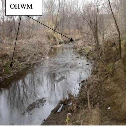
2 Ordinary High Water Mark USACE: Line on a shore established by fluctuations of water indicated by physical characteristics such as a clear, natural line impressed on the bank, shelving, changes in the character of soil, destruction of terrestrial vegetation, the presence of litter and debris, or other appropriate means that consider the characteristics of the surrounding areas.?
3 USACE Determinations Army Corp of Engineers (USACE) has regulation over any water body that meets the definition of a Water of the US. Pursuant to these regulations and interagency agreements, the USACE determines on a case by case basis the extent of geographic jurisdiction. Section 404 of the Clean Water Act defines the lateral limits of jurisdiction over non-tidal water bodies to extend to the Ordinary High Water Mark.
4 How? OHWM determinations are conducted similar to a wetland delineation or a OHWM determination in a fluvial system. Unlike Wetland Delineations there are no required physical characteristics and each are determined on a case by case basis. If physical evidence in the absence of hydrological and geographical evidence is used alone two or more characteristics must be present.
 submit those results for USACE verification after their own site visit, USACE either concurs, requests additional information or offers")
 336-9416 Request for Ordinary High Water Mark Determination Pursuant to Skagit County Code 14.26.8.")
5 USACE Determinations of OHWM Will require the applicant or the applicants third party qualified consultant: to perform visual inspection of shoreline and identify multiple physical characteristics that indicate the extent of the OHWM (conduct a delineation) submit those results for USACE verification after their own site visit, USACE either concurs, requests additional information or offers explanation for disputing the consultants opinion Opportunity for appeal PLANNING & DEVELOPMENT SERVICES 1800 Continental Place Mount Vernon, WA Inspections (360) Office (360) Fax (360) Request for Ordinary High Water Mark Determination Pursuant to Skagit County Code (2)(f) PL# Parcel #: (Please list all parcels if multiple) Street Address: Phone#: Office Use Only Below This Line Date: Owner/Agent Name: (Please circle one) Print Signature: Owner/Agent Signature I grant permission to the field inspector to enter the building site to establish the most landward point of the Ordinary High Water Mark. Staff Person Date: Landmark ADDITIONAL COMMENTS: LOG NUMBER Object Bearing Distance Rev Page 1 of 1


6 Delineation The act of describing or portraying something precisely The action of indicating the exact position of a border or boundary


7 Physical Visual Indicators Natural line impressed in the bank Shelving Changes in the character of soil Destruction of terrestrial vegetation Presence of litter and debris Wracking Vegetation matted down, bent, or absent


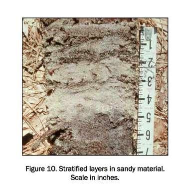
8 Physical Visual Indicators Sediment sorting Leaf litter disturbed or washed away Scour Deposition Multiple observed flow events Defined bed and banks Water Staining Changes in plant communities


9 Inconclusive Data? Other Methods Lake and stream gauge data Elevation data Spillway heights Flood predictions Historic records of water flow Photo credits: Michigan DEQ Statistical evidence


10 Inconclusive Data? Consider characteristics of surrounding environments

11
12 Variations in Delineations OHWM is well defined and is determined regularly in multiple settings. USACE: A Guide to Ordinary High Water Mark (OHWM) Delineation for Non-Perennial Streams in the Western Mountains, Valleys, and Coast Region of the United States 2014 USACE Regulatory Guidance Letter 05-05: Ordinary High Water Mark Identification: December 7, 2005 U.S. ARMY CORPS OF ENGINEERS JURISDICTIONAL DETERMINATION FORM INSTRUCTIONAL GUIDEBOOK Synthesizing the Scientific Foundation for Ordinary High Water Mark Delineation in Fluvial Systems 2016


13 Delineating OHWM- Fluvial Systems Hydrological indicators: stream gauge data & area drainage calculations Geomorphic indicators: Erosion and Deposition Vegetative indicators: Characterizations of vegetation that lives along the channel Photo Credits: INDOT

14 Credits: A Guide to Ordinary High Water Mark (OHWM) Delineation for Non-Perennial Streams in the Western Mountains, Valleys, and Coast Region of the United States

15 Break in slope Credits: A Guide to Ordinary High Water Mark (OHWM) Delineation for Non-Perennial Streams in the Western Mountains, Valleys, and Coast Region of the United States

16 Vegetative Determination Credits: A Guide to Ordinary High Water Mark (OHWM) Delineation for Non-Perennial Streams in the Western Mountains, Valleys, and Coast Region of the United States

17 Changes in sediment characteristics Credits: A Guide to Ordinary High Water Mark (OHWM) Delineation for Non-Perennial Streams in the Western Mountains, Valleys, and Coast Region of the United States
18 Variations in Delineations How are OHWM determinations different from wetland delineations? Why does it matter?


19 Wetland Delineations USACE indicates that when an OHWM is adjacent to a wetland: the Clean Water Act Jurisdiction extents beyond the OHWM to the limits of the adjacent wetland.
20 Wetland Delineations Three REQUIRED components: Hydric soils Hydric Vegetation Hydrology WETLAND DETERMINATION DATA FORM - Midwest Region Project/Site: CR W 200 S City/County: Carroll County Sampling Date: 10/5/17 Applicant/Owner: Jeff Wise State: IN Sampling Point: A Investigator(s): Michelle Dillon Section, Township, Range: 19-24N-1W Landform (hillslope, terrace, etc.): Mitigation Site- Forested Local relief (concave, convex, none): Slope (%): >5% Lat: N Long: W Datum: Soil Map Unit Name: Fincastle- Starks silt loams, 0-2 percent slopes NWI Classification: None Are climatic/hydrologic conditions of the site typical for this time of the year? Yes (If no, explain in remarks) Are vegetation, soil, or hydrology significantly disturbed? Are vegetation, soil, or hydrology naturally problematic? SUMMARY OF FINDINGS Hydrophytic vegetation present? Y Are "normal circumstances" present? Yes (If needed, explain any answers in remarks.) Hydric soil present? Y Is the sampled area within a wetland? Y Indicators of wetland hydrology present? Y If yes, optional wetland site ID: Remarks: (Explain alternative procedures here or in a separate report.) VEGETATION -- Use scientific names of plants. Boundary area between upland and wetland area Absolute % Cover Dominant Species Indicator Staus Dominance Test Worksheet Tree Stratum (Plot size: ) Number of Dominant Species 1 Carpinus caroliniana 20 Y FAC that are OBL, FACW, or FAC: 7 (A) 2 Quercus bicolor 10 Y FACW Total Number of Dominant 3 Acer rubrum 10 Y FAC Species Across all Strata: 8 (B) 4 Percent of Dominant Species 5 that are OBL, FACW, or FAC: 87.50% (A/B) 40 = Total Cover Sapling/Shrub stratum (Plot size: ) Prevalence Index Worksheet 1 Viburnum prunifolium 25 Y FACU Total % Cover of: 2 Cornus amomum 20 Y FAC OBL species 110 x 1 = Acer rubrum 10 N FAC FACW species 95 x 2 = FAC species 75 x 3 = FACU species 25 x 4 = = Total Cover UPL species 0 x 5 = 0 Herb stratum (Plot size: ) Column totals 305 (A) 625 (B) 1 Symphyotrichum puniceum 60 Y OBL Prevalence Index = B/A = Solidago gigantea 40 Y FACW 3 Lycopus americanus 40 Y OBL Hydrophytic Vegetation Indicators: 4 Helenium autumnale 20 N FACW Rapid test for hydrophytic vegetation 5 Elymus riparius 15 N FACW X Dominance test is >50% 6 Andropogon gerardii 15 N FAC X Prevalence index is 3.0* 7 Alopecurus pratensis 10 N FACW Morphogical adaptations* (provide 8 Persicaria hydropiperoides 10 N OBL supporting data in Remarks or on a separate 9 Conyza canadensis 10 N NI sheet) 10 Problematic hydrophytic vegetation* 220 = Total Cover (explain) Woody vine stratum (Plot size: ) 1 N/A 2 Hydrophytic 0 = Total Cover vegetation present? *Indicators of hydric soil and wetland hydrology must be present, unless disturbed or problematic Y Remarks: (Include photo numbers here or on a separate sheet) US Amy Corps of Engineers Midwest Region
 Number of Dominant Species 1 Carpinus caroliniana 20 Y FAC that are OBL, FACW, or FAC: 7 (A) 2")
 40 = Total Cover Sapling/Shrub stratum (Plot size: ) Prevalence Index Worksheet 1 Viburnum prunifolium 25 Y FACU Total % Cover of: 2 Cornus amomum 20 Y FAC OBL species 110 x 1 = 110 3 Acer")
21 Wetland Delineations Vegetative Indicators VEGETATION -- Use scientific names of plants. Absolute % Cover Dominant Species Indicator Staus Dominance Test Worksheet Tree Stratum (Plot size: ) Number of Dominant Species 1 Carpinus caroliniana 20 Y FAC that are OBL, FACW, or FAC: 7 (A) 2 Quercus bicolor 10 Y FACW Total Number of Dominant 3 Acer rubrum 10 Y FAC Species Across all Strata: 8 (B) 4 Percent of Dominant Species 5 that are OBL, FACW, or FAC: 87.50% (A/B) 40 = Total Cover Sapling/Shrub stratum (Plot size: ) Prevalence Index Worksheet 1 Viburnum prunifolium 25 Y FACU Total % Cover of: 2 Cornus amomum 20 Y FAC OBL species 110 x 1 = Acer rubrum 10 N FAC FACW species 95 x 2 = FAC species 75 x 3 = FACU species 25 x 4 = = Total Cover UPL species 0 x 5 = 0 Herb stratum (Plot size: ) Column totals 305 (A) 625 (B) 1 Symphyotrichum puniceum 60 Y OBL Prevalence Index = B/A = Solidago gigantea 40 Y FACW 3 Lycopus americanus 40 Y OBL Hydrophytic Vegetation Indicators: 4 Helenium autumnale 20 N FACW Rapid test for hydrophytic vegetation 5 Elymus riparius 15 N FACW X Dominance test is >50% 6 Andropogon gerardii 15 N FAC X Prevalence index is 3.0* 7 Alopecurus pratensis 10 N FACW Morphogical adaptations* (provide 8 Persicaria hydropiperoides 10 N OBL supporting data in Remarks or on a separate 9 Conyza canadensis 10 N NI sheet) 10 Problematic hydrophytic vegetation* 220 = Total Cover (explain) Woody vine stratum (Plot size: ) 1 N/A 2 Hydrophytic 0 = Total Cover vegetation present? *Indicators of hydric soil and wetland hydrology must be present, unless disturbed or problematic Y Remarks: (Include photo numbers here or on a separate sheet)

22 Wetland Delineations Hydric Soil Indicators


23

24 Wetland Delineations Hydrological Indicators


25
26 Wetland Delineations Same verification procedure applies to a wetland delineation: Submit to USACE for Jurisdictional Verification Additional step of submitting to IDEM when there is no USACE Jurisdiction to determine if it a State regulated wetland Appeal process
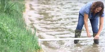
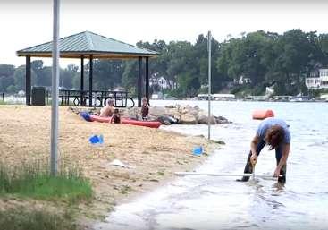
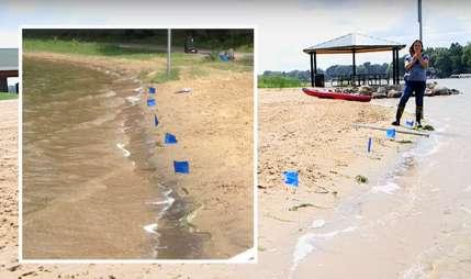
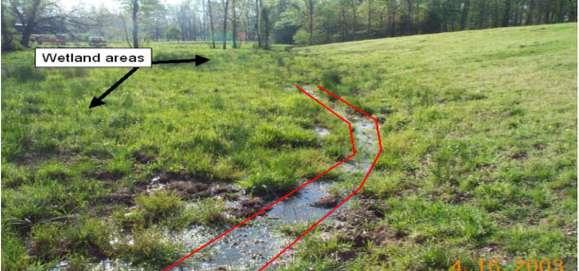
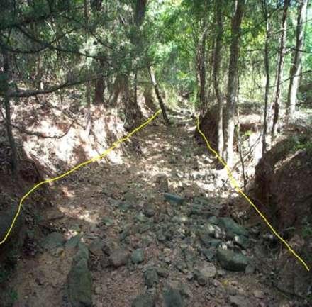
27 Real World Examples of OHWM Determinations


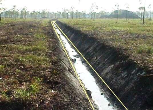
28


29

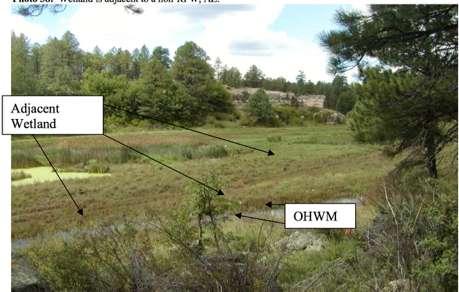

30


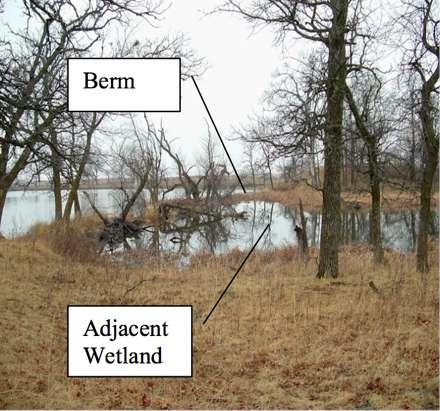
31


32


33
34 How to Determine if a professional is Qualified? Society of Wetland Scientists- Professional Wetland Scientist Certification Army Corps of Engineers list of Prequalified Consultants Certifications from independent organizations: Wetland Training Institute, The Swamp School, Richard Chinn Environmental Courses
35 Consultant Qualifications Appropriate training which qualifies one as a Professional Wetland Scientist includes years of training including 15 semester hours of: Biological Sciences - biology; botany; zoology; general ecology; plant, animal, aquatic or wetlands ecology; invertebrate zoology; taxonomy; marine science; fisheries biology; plant physiology; p;ant taxonomy; plant pathology; plant morphology Physical Sciences- soils, chemistry, hydrology, physics, geology, sedimentology, oceanography, coastal processes, environmental engineering Quantitative Sciences (6 hrs)- math, computer sciences, basic statistics, population dynamics, experimental statistics
36 Additional Requirements In addition, additional course work must be completed in: wetland plant taxonomy; wetland hydrology; general hydrology; soil morphology; classification and mapping; hydric soil identification; wetland restoration and creation; wetland delineation/evaluation; classification; applied wetland ecology and management; wetland creation/mitigation; wetland ecology 5 years full time experience defined as 75% of responsibilities are water/wetland related
37 Questions? Michelle Dillon, PWS (cell)