ELDERBERRY CUSA EXPANSION SUMMARY INFORMATION
|
|
|
- Deirdre Amie Marsh
- 5 years ago
- Views:
Transcription
1
2
3 ELDERBERRY CUSA EXPANSION SUMMARY INFORMATION This information is provided to support the City of Madison s request to expand the Central Urban Service Area (CUSA) to include approximately acres in the Elderberry Neighborhood. Prepared by: City of Madison Department of Planning & Community & Economic Development Planning Division December 6, 2017
4 DESCRIPTION OF THE PROPOSED CUSA EXPANSION AREA Expansion Area The proposed expansion area covers acres and is located in the Elderberry Neighborhood Development Plan planning area. It is contiguous to the Central Urban Service Area (CUSA) on three sides. The CUSA expansion area abuts the current CUSA on the part of the north, all of the east and all of the south sides. See Map 1. Municipal Jurisdiction About acres are currently within the City of Madison, while acres are within the Town of Middleton. All of the Town lands within the planning area will eventually be attached to the City pursuant to the City of Madison and Town of Middleton Cooperative Plan. See Map 2. Need for the Expansion New development is proposed in the western part of the Elderberry Neighborhood. A development concept for the Schewe LP property has been proposed by a potential developer. Development on the Herrling property has also been proposed. These potential development areas are not currently located within the Central Urban Service Area. The addition of the expansion area to the Central Urban Service Area would allow for orderly development in the Elderberry Neighborhood as planned in the Elderberry Neighborhood Development Plan and the City of Madison Comprehensive Plan. Proposed developments in the expansion area would extend to Pioneer Road which is the City s western boundary through at least 2042 pursuant to an intergovernmental agreement with the Town of Middleton. Natural Features The topography of the Elderberry neighborhood planning area is characterized by a series of gently rolling ridges and shallow valleys, with some steeper slopes occurring in the northwestern part of the planning area. A relatively major north-south ridgeline divides the planning area approximately in half, with grades that generally slope to the east and southwest edges of planning area from this central ridge. The highest elevations within the planning area are located in the northwest portion of the area. Other high ground is generally located along the central ridgeline. There are small, isolated wooded areas located within the northwest and central portions of the planning areas, including where Elderberry Road turns due north (Schewe Road). The natural character of the proposed CUSA expansion area is defined by gently rolling hills and open spaces. Steep slopes (12% or greater) are located on part of the Schewe property. The proposed expansion area is located within the Lower Badger Mill Creek watershed which is tributary to the Upper Sugar River which is a cold water community. The proposed expansion area drains to the south via a primary drainageway and tributary drainageways that flow south from the Middleton Community Church area to lands along the eastern edge of the Schewe LP property and the east central part of the Herrling LP property. The primary drainageway passes under Mineral Point Road and into the Pioneer Neighborhood. The primary drainageway includes soils with hydric inclusions. See Map 3. Existing Land Uses The proposed expansion area currently includes agricultural, several residences, open land, woodland, a cemetery and right-of-way. A City of Madison water tower is currently under construction in the northwest corner of the expansion area. See Table 1. 1
5 Cultural Resources Review No archeological sites have been recorded within the expansion area. However, the area has not been surveyed for the presence of archeological resources. Because of the identification of four pre-contact sites in a recent survey of the area and similarities in the landforms, the Wisconsin Historical Society recommends an archeological survey of the expansion area be completed by a qualified archaeologist. The State Archeologist also notes the presence of the West Middleton Lutheran Church Cemetery in the southwest corner of the planning area. See Exhibit 1. PROPOSED LAND USES The Elderberry Neighborhood Development Plan (NDP) recommends a variety of land uses in the expansion area. Low Density Residential (<8 dwelling units/acre) primarily single-family homes on a variety of lot sizes, is recommended for much of the expansion area. Low-Medium Density (8-11 dwelling units/acre) residential uses (e.g. single-family attached, and multi-family units) is recommended for the southeast corner of the expansion area and in the northeast part of the expansion area. Medium Density Residential (12-16 dwelling units/acre) uses such as a variety of multi-family housing types including duplexes, apartments and townhouses are recommended for the southeast part of the expansion area. A small area of Office-Employment Mix uses is recommended in the southeast corner of the expansion area. Two future parks and a drainageway are recommended in the expansion area. The City of Madison Comprehensive Plan recommends Low- Density Residential (0-15 dwelling units per acre), park and open space and employment for the proposed expansion area. See Table 1 and Map 4. The City of Madison is currently updating its Comprehensive Plan and the Elderberry Neighborhood Development Plan. These plans are expected to be adopted in The City of Madison and Town of Middleton Cooperative Plan includes a transition area located within ¼ mile of the east and west sides of Pioneer Road. In this area, residential development is limited to a maximum density of four dwelling units per net acre and the number of units in an attached multifamily structure is limited to four. The Cooperative Plan also requires land divisions in the transition area to provide an 80-foot wide landscaped building setback along Pioneer Road. A prospective developer of the Schewe property, Veridian Homes, has submitted a concept plan for a residential subdivision that includes 227 dwelling units on 88 acres. The concept plan includes a park, open space and several stormwater management facilities in addition to residential development. See Map 5. A conceptual land plan has been submitted by a prospective developer of the Herrling property totaling 1,240 dwelling units on 136 gross acres. See Map 5. Neighborhood commercial, parks, open space and stormwater facilities are also proposed. 2
6 Table 1: Expansion Area Data Land Use Existing Development (acres) Proposed Land Use (acres) Environmental Corridor (acres) Estimated Avg. Units per Acre Estimated Housing Units Low Density Residential Low Density Residential Pioneer Rd. Transition Area Low-Medium Density Residential Medium Density Residential Employment Open Land Stormwater Mgmt./Open Space Institutional Park Agriculture Woodland Right-of-Way Total ,178 Parks Two parks are planned within the expansion area. These parks are each approximately seven acres in size. Additionally, Sauk Heights Park is located one quarter-mile east of the expansion area. It is currently 4.6 acres and is planned for expansion to about 9 acres. Recommended Environmental Corridors The size and configuration of the environmental corridor areas illustrated on the submittal maps will be refined when detailed site plans are developed for the properties in the expansion area. It is recommended that the following areas and facilities, at a minimum, be designated as environmental corridor: The drainageway along the eastern edge of the Trinko and Schewe LP properties and the drainageway that passes through the Herrling Family LP property. The wooded area with steep slopes on the Schewe property. Two proposed parks that are located in the expansion area. All stormwater management facilities that will be dedicated to the public. The total acreage for the proposed environmental corridors is 23.1 acres. Development Phasing It is anticipated that development will begin on the eastern parts of the Schewe and the Herrling properties. These properties are expected to develop in the next five years. There has been developer interest in both properties and utilities are adjacent to these areas. Overall, development is expected to occur from east to west. 3
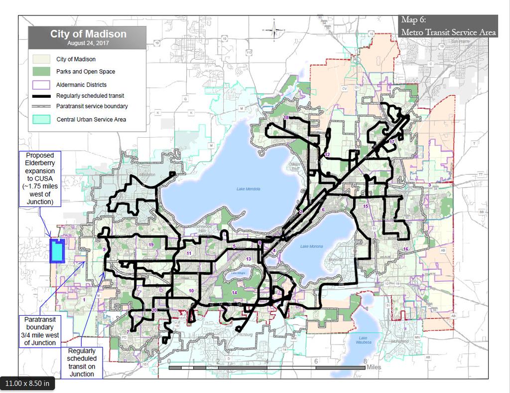
7 TRANSPORTATION RECOMMENDATIONS. Roadways The expansion area will include a variety of roadway cross sections. Mineral Point Road is planned to be a four-lane divided arterial with marked bicycle lanes and a side path. Old Sauk Road will taper down from a four-lane minor arterial to a two-lane collector along the northern edge of the expansion area and will have bicycle lanes. Pioneer Road and two east-west collector streets, Elderberry Road and the extension of White Fox Lane will be two-lane roads with bicycle lanes and parking on one side. Other streets in the expansion area will be local streets. Pedestrian-Bicycle Facilities All City of Madison streets will have public sidewalks and are designed to also accommodate bicycle travel. An off-street pedestrian-bicycle path is planned along the north-south drainageway parallel to Schewe Road as recommended in the Madison Area Transportation Planning Board s Regional Transportation Plan. This is part of a planned north-south path that will serve parts of Madison s west side. A second planned shared use path runs east-west through the southeast part of the expansion area. A bike path is recommended along Mineral Point Road. Transit Service The expansion area falls outside this defined transit service area, using the stops and schedules maintained by Metro Transit under its current operating budget. See Map 6. The closest bus stops with regularly scheduled transit service through most of the day are located along Junction Road (between Old Sauk Road and Mineral Point Road), approximately 1¾ miles east of the proposed expansion area. DESCRIPTION OF PROPOSED FUTURE URBAN SERVICES DELIVERY The full range of City of Madison urban services, including public sewer and water, are provided to the adjacent developed areas and are available for extension into the expansion area. See Map 7. Sanitary Sewer Service It is anticipated that development in the expansion area will generate an average of 271,470 gallons of wastewater per day (gpd) or 189 (gpm). This estimate is based on the assumptions below. Utilizing a peaking factor of 4, it is assumed that the expansion area would generate a peak of 1,085,880 gallons per day or 754 gallons per minute (gpm). Low Density Residential: 310 units at 250 gpd Low Density Residential Transition Area: 470 units at 250 gpd Low-Medium Density Residential: 98 units at 225 gpd Medium Density Residential: 300 units at 175 gpd Employment: 128 employees (0.30 floor area ratio, 75,794 total square feet, 500 square feet per employee) at 15 gpd 4
8 Near term development in the northern portion of the expansion area will be served by a sanitary sewer extended from the east to the intersection of Schewe Road and White Fox Lane. This 10-inch sewer is currently located at Cape Silver Way west of Big Stone Trail and it is expected that the sewer will be extended to Schewe Road and White Fox Lane in It has a design capacity of 582 gpm. Downstream, the 10-inch sewer connects to the 12-inch sewer running east along Old Sauk Road for 677 and then crosses Old Sauk Road extending to the north and connecting to the 15 and 18 diameter sewers through the Blackhawk Subdivision (2,989 gpm capacity). This 18 diameter sewer crosses Pleasant View Road eastward and extends in a greenway through Old Sauk Trail Subdivision (capacity 3,999 gpm). Continuing downstream, the 18 diameter sewer connects to the RIK Interceptor and eventually Madison Metropolitan Sewerage District s (MMSD) Esser Pond Extension. The Lower Badger Mill Creek Interceptor will be extended north from Mineral Point Road to serve the expansion area in This interceptor is 21 inches in diameter between the expansion area and Valley View Road with a design capacity of 3,187 gpm. South of Valley View Road, the interceptor is 27 inches in diameter and connects to a lift station near the intersection of Mid-Town Road and Woods Road. When this lift station nears capacity, it will be relieved by a MMSD interceptor between Mid-Town Road and the City of Verona. Stormwater Management The expansion area is in the upper reaches of the Lower Badger Mill Creek watershed. This watershed encompasses an area on the far west side of Madison and extends south to the City of Verona. The watershed is tributary to the Upper Sugar River, which is a coldwater sport fishery. In 2003, the Lower Badger Mill Creek Stormwater Management Analyses was completed to facilitate better stormwater management planning within the watershed, which was beginning to experience rapid urban development. The project modeled the watershed under existing conditions and under anticipated post-development conditions and recommended strategies to mitigate potential adverse impacts of development on the watershed. The recommendations of this report were adopted into ordinance by the City of Madison. Subsequent to this report, however, stormwater managements standards of the State, City and CARPC have tightened. As a result, the stormwater recommendations for the expansion area exceed the recommendations in the original report, in terms of infiltration, thermal and detention requirements. Within the Elderberry neighborhood, the watershed master plan recommends a regional detention basin along the Lower Badger Mill Creek corridor north of Mineral Point Road. This facility is proposed to have approximately 45 acre-feet of storage. North of this facility, the report proposes a 75-foot wide drainage way going north almost to Elderberry Road. These facilities will be implemented through future development approvals and the Lower Badger Mill Creek Impact Fee District which was adopted in The expansion area includes anticipated locations for stormwater detention/infiltration facilities. These facilities will, at a minimum, be designed to meet the City of Madison and Dane County infiltration requirements which require providing 90% of the predevelopment infiltration volume. When development proceeds in an order such that the City does not have the right, such as an easement or ownership, to increase flows to a downstream channel, infiltration shall be required such that the runoff-volume pre-development to post-development is matched during a 10-year design event. It is required that peak flow rates are matched for the 1, 2, 10 and 100-year storm events. 5
9 It is anticipated that infiltration will occur in all new developments within the expansion area. Once constructed, infiltration areas will be dedicated to the public. The larger treatment areas proposed as part of the watershed master plan, most notably the detention pond just north of Mineral Point Road, will primarily be permanently wet ponds as they are in areas that receive too much direct runoff to sustain infiltration. Additionally, these areas are typically the lowest in the watershed with the least favorable soils for infiltration. These proposed large treatment areas will also be dedicated to the public. Public Water Service Public water service to the expansion area will be provided by the Madison Water Utility through the extension of water mains within Pressure Zones 8, 10 and 11. As development occurs, larger water mains will be extended along the primary roads, with smaller water distribution mains constructed along local streets developed within the expansion area. Based on current water demand projections, annual average daily water demand for the estimated 1178 housing units within the expansion area having an estimated population of 2,875 will be 143,750 gallons per day (gpd). The maximum water demand for a single day is estimated to be 267,375 gallons. The current maximum capacity of the Water Utility s system is 66 million gpd, from system wide well capacity to supply the average day demand is 33 million gpd. Current system wide average day demand is 29.2 million gpd. System wide maximum day demand is currently 49.9 million gpd corresponding to a system wide maximum day capacity of 52.8 million gpd. For this CUSA application, the Water Utility evaluated the water system in this area and determined that it is capable of providing 3,500 gallons per minute for 3.0 hours for firefighting purposes. Earlier this year, the Water Utility started construction of the Blackhawk Water Tower, which is located on City-owned property at the southeast corner of Pioneer Road and Old Sauk Road. This 17-acre site is located on the northern edge of the expansion area. When the project is completed in late 2018, the Blackhawk Water Tower will allow Madison Water Utility to hydraulically merge Pressure Zones 10 and 11 which will increase emergency storage, fire-fighting capacity, and improve system reliability in the service area. Continued development on the west side of Madison will increase the demand for water. It is estimated that average day system wide demand will increase to 34.1 million gpd or 17% by Maximum day demand will increase to 63.8 million gpd or 28%. Current water demands for pressure zones 8, 10, and 11 are 3.82 million gpd for the average day and 8.08 million gpd for the maximum day. Current capacity for the area is 4.82 million gpd for average day conditions and 8.68 million gpd for maximum day. Projected 2040 demands for pressure zones 8 and 10 are 5.42 million gpd for the average day and million gpd. New municipal wells will be required to ensure a reliable supply as the greater west side develops. Growth and expansion of the water system is guided by the Water Utility Master Plan. The Water Utility Master Plan includes a conceptual location for a future Well 32 on City-owned property on South Point Road between Mineral Point Road and Valley View Road. Additional supply capacity is required for the proposed expansion area. Increase in supply capacity to the far western area is planned for and is included in long range budgeting. To provide service to the proposed expansion area a water transmission pipeline will be required along Mineral Point Road. 6
10 Police Protection Services The City of Madison Police Department will provide police protection services to lands within the expansion area that are within the City. The expansion area is part of the Police Department s West District. The West District operates out of a station located on McKenna Boulevard near its intersection with Raymond Road. This station is about four and 1/2 miles from the expansion area. The Madison Police Department s authorized strength (2017) is 468 commissioned personnel, or about 1.88 officers per 1,000 residents (based on the City s estimated 2016 population of 252,551). Lands located in the Town of Middleton will continue to receive services from the Dane County Sheriff s Office Fire Protection and Emergency Medical Services The City of Madison Fire Department provides fire protection including suppression, inspection, community education and emergency medical services to the lands within the City of Madison and other surrounding contracted areas. The closest Madison Fire Station to the expansion area is Station #12 located at 400 South Point Drive. The station is approximately 1 ½ miles away from the proposed Elderberry CUSA addition. Station #12 currently is staffed with an engine crew of 4 personnel. The estimated travel time to the area is approximately 3 to 4 minutes, depending on weather and traffic conditions. Lands located in the Town of Middleton will continue to receive fire protection through the Middleton Fire District and emergency medical services through Middleton EMS. Streets and Sanitation Services For lands within the City of Madison, the Madison Streets Division will provide collection of solid waste, large items, recyclable materials, yard waste, brush, and leaf collection. The Streets Division will also provide street repair, street cleaning and snow and ice control to the City of Madison portions of the expansion area. Currently, these services are provided to the area from the West Side Public Works Facility located on Badger Road. Lands within the Town of Middleton will continue to receive services through service arrangements that the Town establishes. Public Schools The expansion area is in the Middleton-Cross Plains Area School District. Under the School District s current configuration of school attendance areas, students residing in the expansion area would attend West Middleton Elementary School, Glacier Creek Middle School and Middleton High School. The District owns 39.9 acres (next to the Pope Farm) immediately north of the expansion area. Future plans for this land may include an elementary school and middle school. ADDITIONAL INFORMATION Comprehensive Plan and Purpose of the Proposed Expansion The City of Madison is requesting this expansion to the CUSA in order to be able to extend the full range of urban public services, including sanitary sewer service. Beginning urban development in this portion of the Elderberry neighborhood at this time is consistent with the long-range growth recommendations in the City of Madison Comprehensive Plan. The proposed expansion is consistent with the land use recommendations of the Comprehensive Plan, which recommends Low Density 7
11 Residential, Park and Open Space and Employment for the CUSA expansion area. Further, the expansion area is consistent with the 2006 Peripheral Planning Areas Map. Balanced Development Pattern In order to accommodate projected population, housing and employment growth, the City of Madison Comprehensive Plan recommends an efficient, balanced urban development pattern. The recommended development pattern includes infill and redevelopment projects in the established parts of the city, as well as development of new planned urban neighborhoods which are typically located at the edge of the City. The Comprehensive Plan recommends that new neighborhoods incorporate the principles of Traditional Neighborhood Development which is characterized as compact, mixed-use development that makes efficient use of the land and encourages transportation alternatives to the automobile. Agricultural Loss Mitigation The expansion area currently contains some active agricultural lands, and urban development will eventually result in the transition of these lands to more intensive uses. Extensive urban development is taking place adjacent to the expansion area. Development in this area will provide an attractive alternative to the lower-density exurban and rural development that would result in significantly greater loss of farmland. 8
12


13 TOWN OF MIDDLETON Shadow Ridge Trail Map 1: Expansion Area CITY OF MADISON QRS COMPANY Schewe Road TRINKO Old Sauk Road City of Madison CUSA Expansion December 2017 Bear Claw Way Existing CUSA Boundary Proposed CUSA Boundary Existing/Proposed Environmental Corridor Pioneer Road SCHEWE LP Elderberry Road NOLTNER PIONEER FARM HERRLING FAMILY LP Veritas Drive Brader Way Bear Claw Way Mineral Point Road Feet 1" = 800' (8.5x11)
14 MIDDLETON Shadow Ridge Trail CITY OF MADISON QRS COMPANY Schewe Road TRINKO O B Map 2: Municipal Jurisdiction and Property Ownership City of Madison CUSA Expansion December 2017 Existing CUSA Boundary Proposed CUSA Boundary City of Madison Pioneer Road Town of Middleton SCHEWE LP Elderberry Road NOLTNER PIONEER FARM HERRLING FAMILY LP Veritas Drive Brader Way Bear Claw Way Mineral Point Road Feet 1" = 800' (8.5x11)


15 Map 3: Natural Features CITY OF MADISON QRS COMPANY Schewe Road TRINKO Old Sauk Road City of Madison CUSA Expansion December 2017 Bear Claw Way Existing CUSA Boundary Proposed CUSA Boundary Watershed Boundary Pioneer Road Minor Ridgeline 2 Foot Contour SCHEWE LP Soils wth Hydric Inclusions Slope 12% - 20% Slope 20% or Greater Elderberry Road Woodland NOLTNER PIONEER FARM HERRLING FAMILY LP Veritas Drive Brader Way Mineral Point Road Bear Claw Way Feet 1" = 800' (8.5x11)

 Medium Density Residential (12-16 du/acre) Neighborhood Commercial")

16 Map 4: Land Use and Street Plan CITY OF MADISON QRS COMPANY Schewe Road TRINKO Old Sauk Road City of Madison CUSA Expansion December 2017 Bear Claw Way Existing CUSA Boundary Proposed CUSA Boundary Existing/Proposed Environmental Corridor Pioneer Road Recommended Land Use Low Density Residential (<8 du/acre) SCHEWE LP Low-Medium Residential (8-11 du/acre) Medium Density Residential (12-16 du/acre) Neighborhood Commercial Elderberry Road Office - Employment Mix Institutional NOLTNER PIONEER FARM Mixed Use Industrial Park HERRLING FAMILY LP Other Open Space and Stormwater Management Veritas Drive Brader Way Mineral Point Road Bear Claw Way Feet 1" = 800' (8.5x11)
 SCHEWE LP Low-Medium Residential (8-11 du/acre) Medium Density")

17 Map 5: Concept Plans CITY OF MADISON QRS COMPANY Schewe Road TRINKO O B City of Madison CUSA Expansion December 2017 Existing CUSA Boundary Proposed CUSA Boundary Pioneer Road Recommended Land Use Low Density Residential (<8 du/acre) SCHEWE LP Low-Medium Residential (8-11 du/acre) Medium Density Residential (12-16 du/acre) Neighborhood Commercial Elderberry Road Office - Employment Mix Institutional NOLTNER PIONEER FARM Mixed Use Industrial Park HERRLING FAMILY LP Other Open Space and Stormwater Management Veritas Drive Brader Way Mineral Point Road Bear Claw Way Feet 1" = 800' (8.5x11)
18


19 Map 7: Utilities CITY OF MADISON QRS COMPANY Schewe Road TRINKO O B City of Madison CUSA Expansion December 2017 Existing CUSA Boundary Proposed CUSA Boundary 2 Foot Contour Pioneer Road Existing Public Utilities Sanitary Main Water Main SCHEWE LP Proposed Public Utilities Sanitary Main Elderberry Road NOLTNER PIONEER FARM HERRLING FAMILY LP Veritas Drive Brader Way Bear Claw Way Mineral Point Road Feet 1" = 800' (8.5x11)