CVSIM: Linking C2VSIM with CVP-SWP Reservoir Operations
|
|
|
- Melvin Gardner
- 5 years ago
- Views:
Transcription

1 CVSIM: Linking C2VSIM with CVP-SWP Reservoir Operations Tariq N. Kadir, Ph.D., P.E. California Department of Water Resources CWEMF 2018 Annual Meeting April 2, 2018
2 Acknowledgements Jay Lund UC Davis Department of Water Resources In memory: Miguel A. Marino UC Davis Disclaimer This presentation is material extracted from research on a PhD dissertation. It is not official DWR modeling work, nor implies that DWR will be applying it in the future.
3 Outline 1. CVSIM: Central Valley Simulation Model 2. C2VSIM Overview 3. C2VSIM: Historical Level of Development 4. C2VSIM: Projected Level of Development 5. SIM2: Reservoir Operation and Water Allocation Model 6. CVSIM: Linking C2VSIM and SIM2 7. Global Warming Sensitivity Analysis Study 8. Sacramento Valley Conjunctive Use / Water Transfer Study
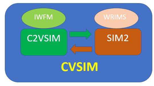
4 1. CVSIM: Central Valley Simulation Model Linking two models: a) Simulation Model: C2VSIM (IWFM driven) b) Systems Model: SIM2 (WRIMS driven) c) ANN-based closure (adjustment) built in (dynamic calculation). Motivation: C2VSIM computes the hydrology including water demands, precipitation runoff, steam-aquifer interaction (seepage), Bypass flows (including weir flows on Sacramento River), adjustments and passes on to SIM2 to compute reservoir releases, surface water diversions, and ground water pumping.
5

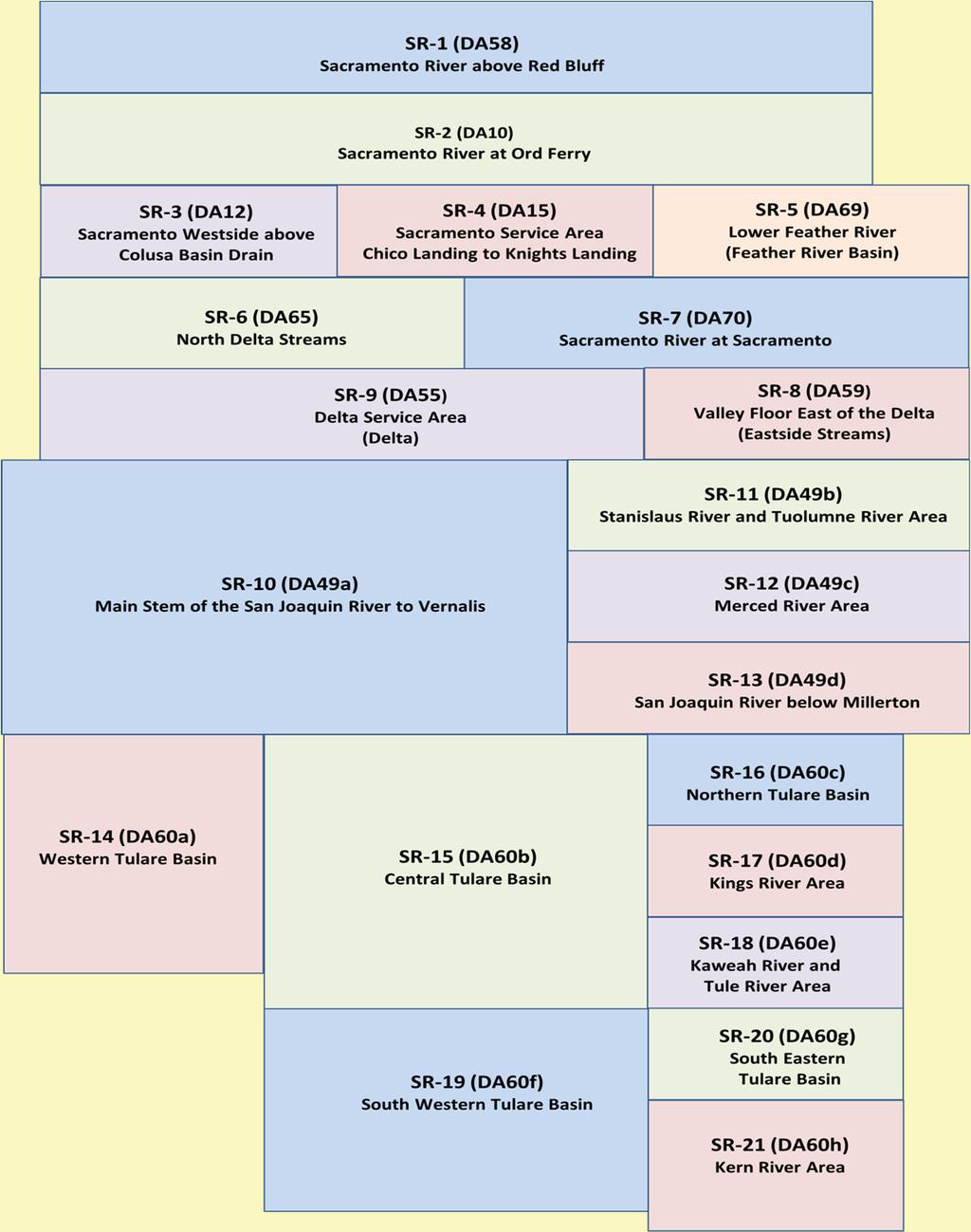
6 2. C2VSIM Overview California Central Valley Simulation Model Finite Element Grid 3 layers 1393 nodes 1392 elements covers ~20,000 sq. mi. Surface Water System 72 stream reaches 97 surface water diversions 2 lakes 8 bypass canals Land Use Process 21 sub-regions 4 Land Use Types Agriculture Urban Native Riparian Simulation (this research) Monthly WY
7
8
9
10 3. C2VSIM: Historical Level of Development Compile sub-regional historical outflows Use C2VSIM to compute historical adjustments = historical outflows minus sub-regional outflows 7 sequential stages Develop ANN for each of sub-region as a function of 14 variables computed within C2VSIM (presentation CWEMF tomorrow) Develop piecewise-linear regression equations for: Moulton, Colusa, Tisdale weirs Fremont weir Sacramento weir Integrate ANN s and weir equations into C2VSIM-historical
11 4. C2VSIM: Projected Level of Development a) Projected level land use GIS-based DWR surveys Corrections Mosaic Aggregate to sub-regional level b) Projected level boundary stream inflows CalSim-II run for DWR 2009 SWP Delivery Reliability Report Historical C2VSIM run. Use monthly averages by WY type c) Projected level diversions See (b) above Data compiled by CH2M-Hill mapping CalSim-II to CVPM (Central Valley Production Model) part of Common Assumptions for CalFED Surface Storage Investigations d) Projected level groundwater pumping: - Run C2VSIM-projected with groundwater pumping adjustments turned on.
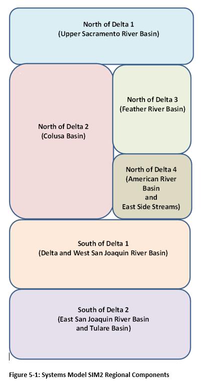
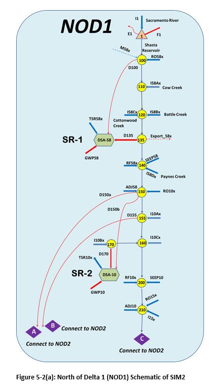
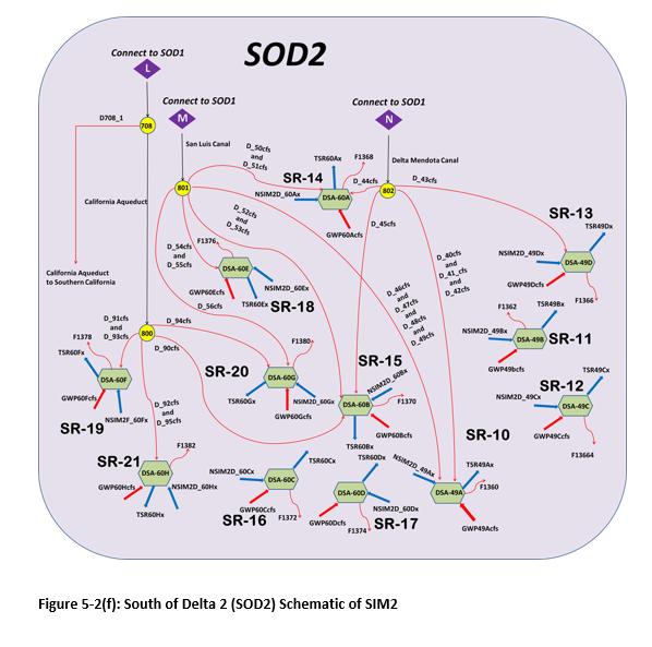
12 5. SIM2: Reservoir Operation and Water Allocation Model Set up model a Mixed Integer Linear Programming problem (MILP). Use DWR s Water Resources Integrated Modeling System (WRIMS) GUI and associated Water Resources Engineering Simulation Language (WRESL) for setting up model. Simulate operations of reservoirs to calculate releases and allocations (diversions and groundwater pumping). Time series of runoff, return flow, stream-aquifer interaction (seepage), by-pass flows, and adjustments (all by sub-region) would come from C2VSIM projected level run. Only Shasta, Oroville, Folsom and San Luis (both CVP and SWP portions) simulated. Remaining reservoir releases in the San Joaquin and Tulare Basins from other sources. Selected operational and institutional constraints incorporated, include: Flood control Minimum instream flow requirements CVP-SWP Coordinated Operating Agreement (COA) Delta Export/Inflow (E/I) ratio as set by SWRCB Map major routing components from C2VSIM as simple as possible through aggregation. Weights for allocation and storage in reservoirs based on priority.
13
14
15 6. CVSIM: Linking C2VSIM and SIM2 Iterative process 84 variables passed from C2VSIM to SIM2 (dynamic) 80 variables passed from SIM2 to C2VSIM (dynamic) 22 variables input directly to SIM2 (fixed) 29 variables local to SIM2 (dynamic) Convergence reached when variables passed in successive iterations negligible (generally 3-5 iterations)
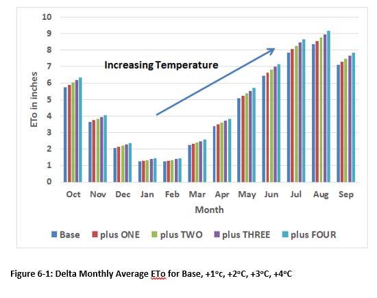
16 7. Global Warming Sensitivity Analysis Study Ambient earth temperatures would increase by up to (or more) 4 o C Study focuses on two major factors due to temperature rise: 1. Increased land use based demands due to increases in crop ETc s. 2. Modification of inflows to reservoirs from upper watersheds because of earlier snowmelt (within a water year). Use DETAW as basis to compute modified ETc s Historical daily ET o in the Delta calculated using Hargreaves-Samani equation, Base Case. Increase min and max daily temperature by 1 0 C 4 0 C and calculate ET o Average ET o for the month Scale ET C for each crop by same percentage as change in ET o Apply to each crop in each of 21 sub-regions in C2VSIM Modified inflows in Shasta, Oroville, and Folsom from DWR Soil and Water Assessment Tool (SWAT) models (Base, 1 0 C 4 0 C)
17
18
19 Selected CVSIM Results
20
21
 in the months of June through September,")
22 8. Sacramento Valley Conjunctive Use / Water Transfer Study Based on the Sacramento Valley Water Management Program (SVWMP). 30 stakeholders forgo their surface water rights of diverting nearly 187 TAF/year in non-wet years (BN, AN, D, C, as defined by the Sacramento River Index) in the months of June through September, and instead pump groundwater from nearly 230 wells to supplement local water needs. The expected decrease in diversions would result in increased inflows to the Delta. Increased inflows the Delta could be used by CVP and SWP projects to meet Delta outflow requirements and increased exports to southern California. Expectations are that groundwater levels would recover during non-operating years. Key questions: How much of the water reaches the Delta: What are the long term impacts on groundwater storage and elevations?

23 Results from CVSIM: Averaged For Years of Operation (56 of 82)

24 Selected CVSIM Results: Averaged For ALL 82 Years


25 Answer to the Two Questions: In the long term only ~20% of cutback in diversions reaches the Delta Program is not sustainable due to increased declines in groundwater storage & elevations
26