From Academic to Industry for Solar Resources. MINES ParisTech Lionel Menard
|
|
|
- Violet Sims
- 5 years ago
- Views:
Transcription
1 From Academic to Industry for Solar Resources MINES ParisTech Lionel Menard Solar Resource Assessment with the Global Atlas for Renewable Energy ISES Webinar 16/06/2016 1
 Ranked # 1 in France as the institute for partnership research (Industry & Technology 2014) Center for Observation, Impacts, Energy Assessment of")
2 MINES ParisTech MINES ParisTech French school of engineers with 225 years of history as a Graduate School 260 professors-researchers 1440 students 18 research centers (Earth Science, Environment, Energy and Process, Materials, Math, Economics) Ranked # 1 in France as the institute for partnership research (Industry & Technology 2014) Center for Observation, Impacts, Energy Assessment of solar, wind and marine resources for renewable energy using Earth Observation data (Model, satellite imagery and in-situ) Assessment of environmental impacts through the use of Life Cycle Assessment (LCA) approaches Dissemination of scientific data based on open standards through a Spatial Data Infrastructure 2
 MINES ParisTech Cloud index based approach HS-2 operationally used for SSI databases")
 SPACE ATMOSPHERE I 0 absorption scattering B Atmospheric parameters derived from satellite reflection 990+ citations of the Heliosat methods in Web of Science OCEAN, GROUND")
3 Satellite based solar resource assessment The Heliosat methods and the Helioclim databases of Surface Solar Irradiance Heliosat methods: Open methods (Heliosat ), using images from geostationary meteorological satellite to provide estimation of Surface Solar Irradiance Heliosat-2 (2004) MINES ParisTech Cloud index based approach HS-2 operationally used for SSI databases Helioclim-1 and Helioclim-3 Heliosat-4 (2009) MINES ParisTech / DLR (German Aerospace) Cloud properties based approach HS-4 operationally used for the solar radiation service in Copernicus Atmosphere Monitoring Service (CAMS) SPACE ATMOSPHERE I 0 absorption scattering B Atmospheric parameters derived from satellite reflection 990+ citations of the Heliosat methods in Web of Science OCEAN, GROUND target Blanc, P., B. Gschwind, M. Lefèvre, and L. Wald The HelioClim Project: Surface Solar Irradiance Data for Climate Applications. Remote Sensing 3 (12): doi: /rs
 Spatial coverage and resolution of HelioClim-3 HelioClim-3 (HC-3) Heliosat-2 Meteosat")
4 Satellite based solar resource assessment The Heliosat methods and the Helioclim databases of Surface Solar Irradiance HelioClim-1 (HC-1) Heliosat-2 Meteosat First Generation Spatial resolution: km Temporal resolution: daily values Temporal coverage: Freely available 2011 (GEOSS Data-CORE) Spatial coverage and resolution of HelioClim-3 HelioClim-3 (HC-3) Heliosat-2 Meteosat Second Generation Spatial resolution: 3 km Temporal resolution: 15 min Temporal coverage: since : free access (maps, times series) real-time: commercial activities and tailored services by Transvalor Innovation 4+ millions / year of database accesses 3 km 3,5 km 4 km 4,5 km 5 km 6 km 7 km 8 km 10 km > 12 km 4
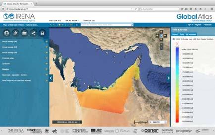
5 Contribution to the Global Atlas MINES ParisTech contribution As a data provider (over 300 resources) HelioClim-1 Meteosat coverage - 32 maps of yearly mean of global Irradiance Access to 21 years of time series in the Global Atlas (Tools - WPS) HelioClim-3 Meteosat coverage - 39 maps of monthly mean GHI, DHI and DNI 2005 Mozambique 52 maps of 10-years average ( ) of monthly mean of daily irradiation GHI, DHI and DNI Egypt 92 maps of 10-years average ( ) of monthly mean of daily irradiation GHI, DHI and DNI SolarMedAtlas GHI DNI maps of South Mediterranean countries As a data integrator for the renewable energy community BOM Australia 20 maps of monthly and seasonal average daily solar exposure MERRA World 30 gridded maps (Temp., pressure, humidity, wind speed and direction) As an infrastructure provider ( Operate the Spatial Data Catalog for the Global Atlas (over 1600 resources / metadata) Provide link to GEOSS (Global Earth Observation System of Systems) 5
6 Importance of being part of the Global Atlas Academic Support for student and engineer education Free Solar training - Research One stop shop for data worldwide for renewable energy Central tool for dissemination of renewable energy resources Leverage visibility of data providers Partnership research toward industry Allows advertisement of data for pay to potential customers Enable industries partnership for R&D 6
 A \"mashup\" with")


 for the")


7 High resolution local solar atlas (FP7 ENDORSE) A "mashup" with Helioclim-3 / In-situ measurements / SRTM ( User profile: Governmental and private sector Geographical analysis of local solar potential Sitting and sizing power plants 55 HelioClim-3 database In-situ measurements irradiaeon datasets Raw HC-3 CalibraEon with ground staeons of Météo-France and 3 dedicated ground staeons High resolution (200 m) monthly and yearly sums of irradiations (kwh/m 2 ) for the region PACA BNI DHI GHI Downscaled and calibrated HC-3 Downscaling GHI/DNI map IrradiaEon components on Elted plane Local alitude deviaeon Local horizon computaeon SRTM: 100 m DEM 7
 GIS analysis with additional Open")


8 High resolution local solar atlas (FP7 ENDORSE) GIS analysis with additional Open geographical layers (Over 80 layers) m irradiaeon maps Valida;on of irradia;on data 21 Météo-France ground sta;ons used for calibra;on (cross-valida;on) 3 dedicated ground sta;ons used as test sta;ons Territorial units District units Natural reserves Flood risks DEM Slopes DEM Aspects Land-use Distance to electric source points Corrine Land Cover 2006 GHI: bias < 1 %, RMSE ~ 5 % (~7 kwh/m2) BNI: bias < 1 %, RMSE ~8 % (~12.5 kwh/m2) 8
 for the")

 Helps in understanding the potential of a given site")
9 Global Atlas Tools HC1 Time Series Satellite-based solar time series Daily values of Surface Solar Irradiation (SSI) for the period Research activities: Select (up to 5 locations), view and download Compare to ground measurements stations Model electricity production of a given PV system (PVSYST, RetScreen, HOMER) Helps in understanding the potential of a given site Comparing PV technologies 9
10 Industry requirements Project development: consolidation phases and bankable report Need of accurate and long-term solar and meteorological datasets and related uncertainties for the selected site Long term (10y+) time series of solar and meteorological data from satellite and models Short term (1y+) in-situ ground measurements for the site adaptation / calibration / merging Need tailored expertise services HelioClim-3 - > Transvalor Innovation Annual subscriptions (Archive, Real Time, Forecast) On-request services (Maps, Calibration, Completion, TMY, ) Global Atlas fitness for use methodology Concept paper ( Metadata tags: GlobalAtlasBusiness 10


")
11 Additional information for the Global Atlas Possible addition to the Global Atlas Access to in-situ measurements time series (EC funded ConnectinGEO project) Environmental performance of PV systems (IEA PVPS Task12) 11


12 Find out more. 12