Clallam County Shoreline Master Program Update
|
|
|
- Marcus Small
- 5 years ago
- Views:
Transcription


1 Clallam County Shoreline Master Program Update Board of Commissioners Work Session November 13, 2017
2 Topics Buffers Channel Migrations Zones (CMZs) Mitigation and No Net Loss
3 Importance of Buffers Provide fish & wildlife habitat Protect water quality Provide space for natural processes to occur Protect people and property from risks e.g., erosion, landslides, channel movement Necessary to meet the State s no net loss standard

4 Buffer widths needed to protect stream functions (in meters) Source: Stream- Riparian Ecosystems in Puget Sound Lowland Eco-Region: A Review of Best Available Science. Watershed Ecology LLC, 2003
5 Function Effective Buffer Range (feet) Minimum Buffer Recommendations and Sources Fine Sediment Removal Broadmeadow and Nisbet (2004) [49 to 213 feet] Desbonnet et al. (1994) [80% at 82 feet] Lynch et al. (1985) [75-80% at 98 feet] Sweeney and Newbold (2014) [65% at 33 feet, 85% at 98 feet] Wenger (1999) [ feet] Erosion Control/Bank Stabilization Buffers for Protecting Shoreline Functions Water Quality Burckhardt and Todd (1998) [ feet] Cederholm (1994) [125 feet] Christensen (2000) [100 feet] FEMAT (1993) [98 feet larger in braided channels] Nitrogen and Phosphorus Removal Mayer et al. (2005) [75% at 92 feet] (Nitrogen) Vidon and Hill (2007) [66 feet] (Nitrogen) Wenger (1999) [50 to 100 feet] (Nitrogen) Dillaha (1993) [78% at 30 feet] (Phosphorus)
6 Function Large Woody Debris Recruitment Buffers for Protecting Shoreline Functions Habitat Effective Buffer Range (feet) Minimum Buffer Recommendations and Sources Christensen (2000) [100 to 180 feet] May (2003) [100 to 180 feet provide 80-90% LWD] Sweeney and Newbold (2014) [100 feet or 1 Site Potential Tree Height)] Organic Matter Input FEMAT (1993) [100 feet] Hawes and Smith (2005) [ feet] Shade (Water Temperature) FEMAT (1993) [200 feet for mature forest equivalent] Lynch et al. (1985) [100 feet for mature forest] Sweeney & Newbold (2014) [full protection at 100 feet] General Wildlife Habitat Castelle et al. (1992) [100 feet for beaver] Goates (2006) [240 feet to protect 90% of hibernation and nesting and 148 feet for bird communities] Knutson and Naef (1997) [ feet for salmonids] May (2003) [98 to 230 feet for small mammals]
7 Stream Buffer Effectiveness
8 How were buffer regulations developed? 1. Used information from the inventory and characterization report 2. Reviewed the scientific literature 3. Considered existing buffers as a starting point 4. Analyzed the current development patterns buffers and setbacks should be tailored to local conditions including existing shoreline functions and existing and planned land use and public access. Buffers and setbacks likely will vary to reflect different shoreline conditions and functions. 5. Included additional measures Proposed SMP includes multiple protective measures that work in conjunction with the buffer widths to maintain shoreline functions 6. Considered the public s perspective
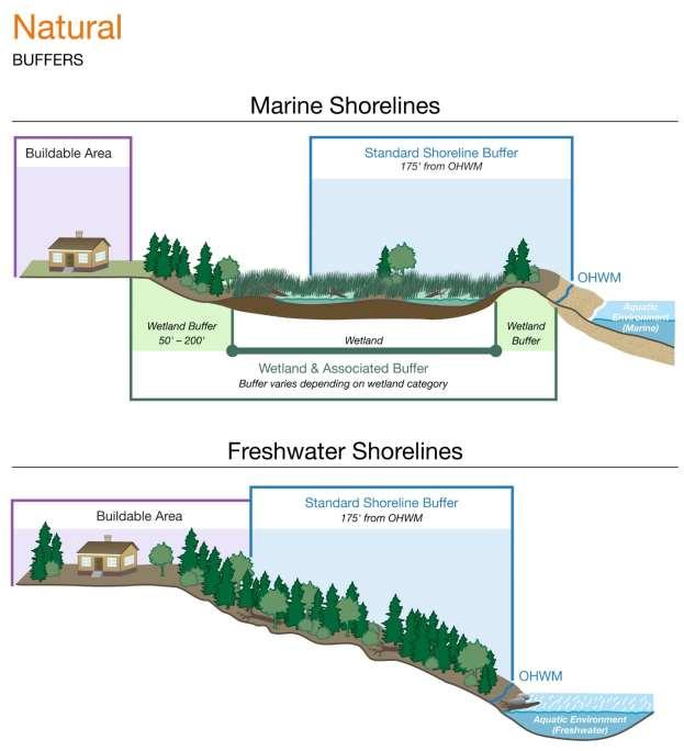
9 Proposed SMP Buffers and Setbacks Are generally wider than existing SMP setbacks Buffers must be well vegetated Some uses are allowed in the buffer Buffers don t apply to Forestry or Agriculture Special allowances for buffers on small lots Some clearing is allowed to provide views and beach access

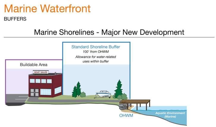
10 Proposed Shoreline Buffer Widths: Minor & Major New Development Overlapping Buffers: In the event that buffers for any shorelines and/or critical areas are contiguous or overlapping, the landward-most edge of all such buffers shall apply. Lake Sutherland Buffer: Minor new development buffer is 35 feet landward of the OHWM regardless of lot depth.
11 Critical Area Buffers Also Apply Critical Area Width Notes Wetlands Depends on wetland category Fish and Wildlife Habitat Areas Landslide Hazard Areas Bluffs (non CMZs May or may not be greater than SMP buffers Depends on Habitat Management Plan Depends on type of bluff
12

13

14 Additional buffer for Landslide Hazard

15 Additional buffer for Landslide Hazard
16 50 300


17 Channel Migration Zones (CMZs) Randy Johnson photos
18 Channel Migration Zones - Definition Areas within which the stream channel can reasonably be expected to migrate over time as a result of normally occurring hydrological and related processes when considered with the characteristics of the river and its surroundings.

19 Channel Migration Zones Lyre River Source: Draft Channel Migration Assessment Clallam County, by WA. Dept. of Ecology and GeoEngineers (April 2013). Aerial Photo Date: 2010 CMZs exclude: Areas protected from channel movement by permanent levees, or Infrastructure improvements such as roads and bridges constructed and maintained by public agencies.

, April 2013 Dungeness River")
20 Detailed CMZ Studies by Ecology & Jamestown S Klallam Tribe For WRIA 18 and 19 (Drain to Strait of Juan de Fuca), December 2011 For WRIA 20 (Drain to Pacific Ocean), April 2013 Dungeness River (October 2013)
21 County Rivers with Mapped CMZs Dungeness River Morse Creek Elwha River Indian Creek Salt Creek Pysht River Lyre River East Twin River West Twin River Deep Creek Clallam River Hoko River Little Hoko River Herman Creek Sekiu River North Fork Sekiu River
22 State CMZ Mapping Methods Rely on Existing Data: Geology, soils, topography, and other data Aerial photo analysis Includes an Erosion Hazard Factor: ½ to 1 width of the active channel corridor, adjusted to local conditions. The active channel generally corresponds to the meander belt of the active channel (unvegetated area) and has a width approximately the meander amplitude of the river reach. Important caveats: Do not include field verification Not based on risk probability (except mouth of Morse Creek) Should only be used as a guideline for identifying areas where more detailed channel migration zone studies should be conducted
23 Changes in CMZ Regulations Question: Why change from current CAO requirement of 50-foot buffer from edge of Channel Meander Zone? Answers: New maps are Best Available Science The probability of erosion is neither steady through time, nor uniformly distributed throughout the CMZ
24 Proposed CMZ Regulations: If County maps indicate a potential channel migration hazard on or adjacent to a proposed use or development site, the applicant shall either: Locate the proposal landward of the potential channel migration hazard area as indicated on the map which already includes an erosion hazard buffer; or Submit a channel migration zone study, prepared by a geologist, engineering geologist, or professional engineer
25 Geotechnical Reports for Development in CMZs Must show the parcel/development site: Is effectively protected (disconnected) from the CMZ; or Has minimal risk of channel migration Administrator can prohibit development or require a buffer based on results of report (Ecology CMZ maps already include erosion hazard buffers)
26 Time Required for CMZ Evaluation (Estimated) Description Compile, display and review available info Apply probabilistic lateral migration method Staffing (person-days) Senior River Scientist/Engineer Technical specialist / Spatial analyst Assess avulsion probability Fieldwork to check results for 1-river mile reach Write erosion/avulsion risk report 1 (excluding travel) 1 (excluding travel) Estimated totals 3 days 3.5 days

27 Potential CMZ: Quillayute & Bogachiel River Confluence


28 Potential CMZ: Quillayute & Bogachiel River Confluence Relative Water Surface Elevation (RWSE)

29 Potential CMZ: Quillayute & Bogachiel River Confluence Geology
30 Development Examples
31 Shoreline Residential Conservancy: Dungeness Bluffs Exceptional Feeder Bluff
32 150 ft Landslide Hazard Buffer 125 ft Shoreline Buffer
33 House Footprint 1.2 acre lot; 5,000 SF footprint
34 Summary Development complies with buffer requirements; home is outside of SMP jurisdiction No geotechnical studies or mitigation required No additional vegetation requirements
35 Shoreline Residential Intensive
36 Common-Line Setback

37 Revegetation View / Access Corridor House Footprint 0.5 acre lot; 2,200 SF footprint
38 Summary Common-line buffer used to determine buffer width Mitigation (revegetation) required within buffer area; with allowance for a view corridor Building envelope limited to 2,500 SF
39 Shoreline Residential Conservancy: Dungeness River Dungeness River
40 Floodplain Dungeness River
41 Channel Migration Zone Dungeness River
42 Class II Wetland Dungeness River
43 100 Class II Wetland Buffer Dungeness River 125 Shoreline Buffer
44 House Footprint Dungeness River
45 Summary Structure located landward of floodplain and CMZ and wetland buffers, and is over 200 feet from the shoreline Project is located outside of SMP jurisdiction, only a County building permit is needed
46 Lake Sutherland
47 35 Buffer
48 Vegetation Retention View / Access Corridor
49 House Footprint New Dock ¾ acre lot; 2,100 SF footprint
50 Summary Shoreline vegetation is retained, with allowance for a view / access corridor Home is oriented to avoid removal of large trees Dock requires a shoreline permit if FMV exceeds $10,000 and probably an Hydraulic Permit from WDFW
51 Freshwater Residential: Morse Creek
52
53 Floodplain

54 Potential Channel Migration Zone
55 ¾ acre lot; 1,700 SF footprint House Footprint
56 Summary Entire parcel within CMZ, development approval is subject to geotechnical study Must show parcel is disconnected or has minimal risk of channel migration based on assessment of: Geology Channel type Lack of evidence of avulsion risk Land cover/ vegetation Other factors
57 Ecological Function What is No Net Loss (NNL)? As shoreline development occurs, ecological functions stay the same (or are improved) over time Existing conditions Development (with mitigation) and Restoration Time
58 Tools for Achieving No Net Loss Locate, design and mitigate development within a watershed context Prohibit non-water-dependent and non-preferred shoreline uses Require that all future shoreline development minimizes further degradation of the shoreline environment Require buffers and setbacks Establish appropriate shoreline environment designations Establish strong policies and regulations Require mitigation sequencing Develop policies and plans for restoration Recommend actions outside shoreline jurisdiction
59 Mitigation and No Net Loss Mitigation sequence (in order of priority): Avoiding the impact Minimizing the impact Rectifying the impact (e.g., restore affected environment) Reducing or eliminating the impact over time Compensating for impact by replacing, enhancing, or providing substitute resources or environments Monitoring the impact of compensation projects and taking appropriate corrective actions.
60 No Net Loss Overall SMP policies and regulations (e.g., buffers) are designed to achieve no net loss on a programmatic scale SMP standards defines standards that each development must meet to achieve no net loss at the project scale County must track environmental indicators of NNL over time
61 NNL Environmental Indicators Percent of mapped feeder bluffs with armoring (percent classified as modified); Status of salmon stocks; Status of shellfish beds (frequency of closures); Length of stream bordered by/confined by levees, excluding setback levees; Number of overwater structures per mile of shore and number of overwater structures per mile of sediment transport zone; Number of tidal barriers; Percent of aquatic area supporting submerged aquatic vegetation (e.g., kelp, eelgrass); Percent closed canopy forest within two hundred (200) feet of the ordinary high water mark; Percent impervious surface within two hundred (200) feet of the ordinary high water mark; and Area of undeveloped floodplains/channel migration zone.
62 Thank you