Ontario Ministry of the Environment and Climate Change - Record of Site Condition #
|
|
|
- Logan Sparks
- 5 years ago
- Views:
Transcription
1 Ontario Ministry of the Environment and Climate Change - Record of Site Condition # Record of Site Condition Under Part XV.1 of the Environment Protection Act Summary Record of Site Condition Number Date Filed to Environmental Site Registry 2016/01/14 Certification Date 2015/12/18 Current Property Use Industrial Intended Property Use Industrial Certificate of Property Use Number No CPU Applicable Site Condition Standards** Full Depth Generic Site Conditions Standard, with Non-potable Ground Water, Medium and Fine Textured Soil, for Industrial property use Property Municipal Address 50 SHAMROCK ROAD, LONDON, ON, N6E 2Z2 Notice to Readers Concerning Due Diligence This record of site condition has been filed in the Environmental Site Registry to which the public has access and which contains a notice advising users of the Environmental Site Registry who have dealings with any property to consider conducting their own due diligence with respect to the environmental condition of the property, in addition to reviewing information in the Environmental Site Registry. Contents of this Record of Site Condition This record of site condition consists (RSC) of this document which is available to be printed directly from the Environmental Site Registry as well as all supporting documentation indicated in this RSC to have been submitted in electronic format to the Ministry of the Environment and Climate Change. Filed Record of Site Condition # on 2016/01/14 1 of 20
2 Part 1: Property Ownership, Property Information and Owner s Certifications Information about the owner who is submitting or authorizing the submission of the record of site condition Owner name Mailing address SAMUEL JOHN SHIRLEY 595 EXETER ROAD, LONDON Ontario, Canada Postal Code N6E 2Z2 Phone (519) Fax (519) address John@spcprojects.ca Filed Record of Site Condition # on 2016/01/14 2 of 20
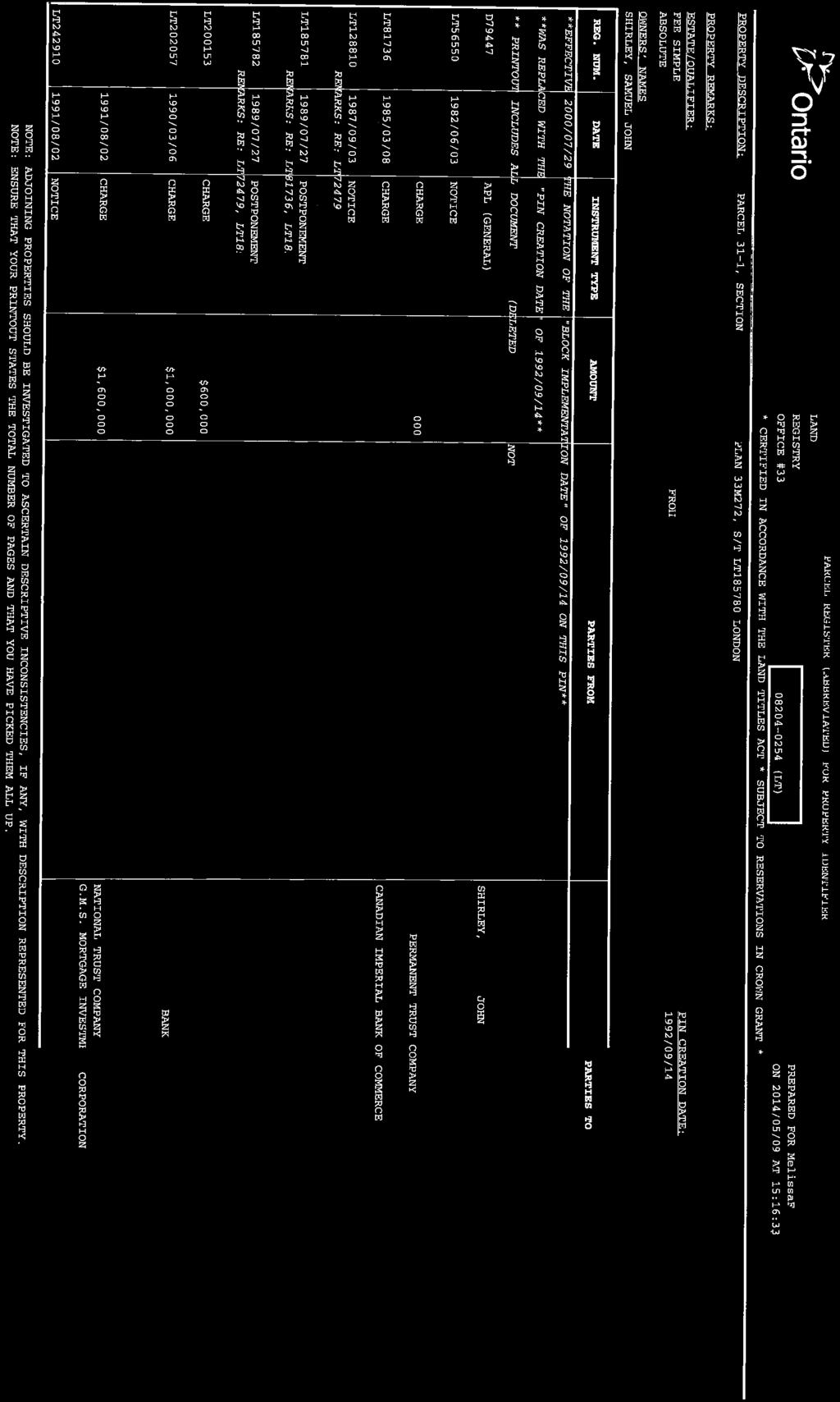
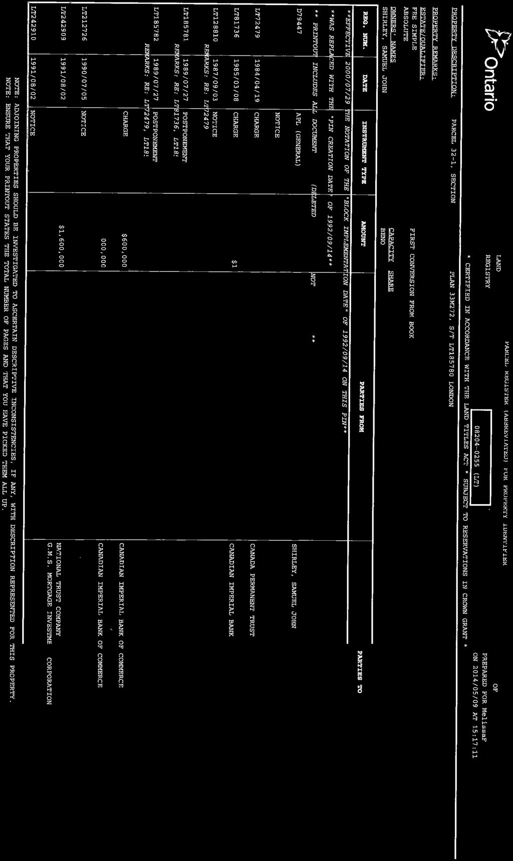
3 Record of site condition property location information Municipal address(es) Municipality Legal description Assessment roll number(s) Property identifier number(s) 50 SHAMROCK ROAD, LONDON, ON N6E 2Z2 London See attached Lawyer s letter (LT) (LT) (LT) (LT) (LT) (LT) (LT) (LT) (LT) Record of site condition property geographical references Coordinate system UTM Datum NAD 83 Zone 17 Easting 481, Northing 4,752, Record of site condition property use information The following types of property uses are defined by the Regulation: Agricultural or other use, Commercial use, Community use, Industrial use, Institutional use, Parkland use, and Residential use. Current property use Intended property use Certificate of property use has been issued under section of the Environmental Protection Act Industrial Industrial No Filed Record of Site Condition # on 2016/01/14 3 of 20
4 Please see the signed statements of property owner, or agent, or receiver at the end of this record of site condition The rest of this page has been left intentionally blank Filed Record of Site Condition # on 2016/01/14 4 of 20
5 Part 2: List of reports, summary of site conditions and qualified person s statements and certifications Qualified person's information Name Type of membership under the Professional Geoscientists Act JAMES C CULLEN Practising member Membership number 0984 Quallified person's employer name Mailing address GOLDER ASSOCIATES LTD. 210 SHELDON DRIVE, CAMBRIDGE Ontario, N1T 1A8 Canada Phone (519) Fax (519) address jcullen@golder.com Municipal information Local or single-tier municipality London Ministry of the Environment and Climate Change District Office District office District office address London District Office 733 Exeter Road, London ON N6E 1L3 Filed Record of Site Condition # on 2016/01/14 5 of 20
6 Phase one environmental site assessment report Document used as the phase one environmental site assessment report and updates in submitting the record of site condition for filing The date the last work on all of the records review, interviews and site reconnaissance components of the phase one environmental site assessment was done (refer to clause 28(1) (a) of O. Reg. 153/04) (yyyy/mm/dd) Type of report Phase one environmental site assessment Report title PHASE I ENVIRONMENTAL SITE ASSESSMENT, Lots 28 to 36 of Registered Plan 33M-272, London, Ontario Date of report (yyyy/mm/dd) Author of report James C. Cullen Name of consulting company GOLDER ASSOCIATES LTD. Reports and other documents related to the phase one environmental site assessment Reports and other documents relied upon in certifying the information set out in section 10 of Schedule A or otherwise used in conducting the phase one environmental site assessment Report title Date of report (yyyy/mm/dd) Author of report Name of consulting company N/A Filed Record of Site Condition # on 2016/01/14 6 of 20
7 Phase two environmental site assessment report Document used as the phase two environmental site assessment report and updates in submitting the record of site condition for filing The date the last work on all of the planning of the site investigation and conducting the site investigation components of the phase two environmental site assessment was done (refer to clause 33.5(1)(a) of O. Reg. 153/04) (yyyy/mm/dd) Type of report Phase two environmental site assessment Report title Phase II Environmental Site Assessment, Lots 28 to 36, Registered Plan 33M-272, London, Ontario Date of report (yyyy/mm/dd) Author of report James C. Cullen Name of consulting company GOLDER ASSOCIATES LTD. Reports and other documents related to the phase two environmental site assessment Reports and other documents relied upon in making any certifications in the record of site condition for the purposes of Part IV of Schedule A or otherwise used in conducting the phase two environmental site assessment Report title Date of report (yyyy/mm/dd) Author of report Name of consulting company N/A Filed Record of Site Condition # on 2016/01/14 7 of 20
8 Environmental condition Section 41 applies? Section 43.1 applies? No No Site condition information Certification date (yyyy/mm/dd) 2015/12/18 Total area of record of site condition property (in hectares) Number of any previously filed record of site condition that applies to any part of the record of site condition property Number of any previously filed transition notice that applies to any part of the record of site condition property Soil texture Assessment/restoration approach Site investigation includes the investigation, sampling and analysis of ground water? Is there soil present that is sufficient to investigate, sample and analyze soil on, in or under the property in accordance with s. 6, Schedule E of O.Reg. 153/04? Site investigation includes the investigation, sampling and analysis of soil on, in or under the property which is used in the record of site condition? Name of the laboratory used to analyze any samples collected of soil, ground water or sediment Ground water condition (potable, non-potable) Medium and fine Full depth generic Yes Yes Yes AGAT LABORATORIES INC. Non-potable Applicable site condition standard TABLE 3 Local or single-tier municipality non-potable written notification date 2015/10/22 Filed Record of Site Condition # on 2016/01/14 8 of 20
9 Table 1 Maximum contaminant concentrations compared to applicable site condition standards Measured concentration for contaminants in soil Contaminant name Maximum concentration Applicable site condition 1 Boron (Hot Water Soluble)* µg/g 2 Chromium VI < µg/g 3 Cyanide (CN-) < µg/g Unit of measure 4 Electrical Conductivity ms/cm 5 Mercury < µg/g 6 Sodium Adsorption Ratio Petroleum Hydrocarbons F1**** 5 65 µg/g 8 Petroleum Hydrocarbons F2 < µg/g 9 Petroleum Hydrocarbons F µg/g 10 Petroleum Hydrocarbons F µg/g 11 Aldrin µg/g 12 Chlordane µg/g 13 DDD µg/g 14 DDE µg/g 15 DDT µg/g 16 Dieldrin µg/g 17 Endosulfan < µg/g 18 Endrin < µg/g 19 Heptachlor µg/g 20 Heptachlor Epoxide µg/g 21 Hexachlorobenzene µg/g 22 Hexachlorobutadiene < µg/g 23 Hexachlorocyclohexane Gamma µg/g 24 Hexachloroethane < µg/g 25 Methoxychlor < µg/g 26 Antimony < µg/g 27 Arsenic 4 18 µg/g 28 Selenium < µg/g 29 Barium µg/g 30 Beryllium µg/g 31 Boron (total) µg/g 32 Cadmium < µg/g 33 Chromium Total µg/g 34 Cobalt µg/g 35 Copper µg/g...continued on next page Filed Record of Site Condition # on 2016/01/14 9 of 20
10 Table 1 Maximum contaminant concentrations compared to applicable site condition standards Measured concentration for contaminants in soil Continued from previous page... Contaminant name Maximum concentration Applicable site condition 36 Lead µg/g 37 Molybdenum µg/g 38 Nickel µg/g 39 Silver < µg/g 40 Thallium < µg/g 41 Uranium µg/g 42 Vanadium µg/g 43 Zinc µg/g 44 Benzene < µg/g 45 Ethylbenzene < µg/g 46 Toluene < µg/g 47 Xylene Mixture < µg/g Unit of measure Filed Record of Site Condition # on 2016/01/14 10 of 20
11 Table 1 Maximum contaminant concentrations compared to applicable site condition standards (Continued) Ground water Contaminant name Maximum concentration Applicable site condition 1 Acetone µg/l 2 Bromomethane < µg/l 3 Carbon Tetrachloride < µg/l 4 Chlorobenzene < µg/l 5 Chloroform µg/l 6 Dichlorobenzene, 1,2- < µg/l 7 Dichlorobenzene, 1,3- < µg/l 8 Dichlorobenzene, 1,4- < µg/l 9 Dichlorodifluoromethane < µg/l 10 Dichloroethane, 1,1- < µg/l 11 Dichloroethane, 1,2- < µg/l 12 Dichloroethylene, 1,1- < µg/l 13 Dichloroethylene, 1,2-cis- < µg/l 14 Dichloroethylene, 1,2-trans- < µg/l 15 Dichloropropane, 1,2- < µg/l 16 Dichloropropene,1,3- < µg/l 17 Ethylene dibromide < µg/l 18 Hexane (n) < µg/l 19 Methyl Ethyl Ketone < µg/l 20 Methyl Isobutyl Ketone < µg/l 21 Methyl tert-butyl Ether (MTBE) < µg/l 22 Methylene Chloride < µg/l 23 Styrene < µg/l 24 Tetrachloroethane, 1,1,1,2- < µg/l 25 Tetrachloroethane, 1,1,2,2- < µg/l 26 Tetrachloroethylene < µg/l 27 Trichloroethane, 1,1,1- < µg/l 28 Trichloroethane, 1,1,2- < µg/l 29 Trichloroethylene < µg/l 30 Trichlorofluoromethane < µg/l 31 Vinyl Chloride < µg/l 32 Bromodichloromethane < µg/l 33 Bromoform < µg/l 34 Dibromochloromethane < µg/l 35 Petroleum Hydrocarbons F1**** < µg/l Unit of measure...continued on next page Filed Record of Site Condition # on 2016/01/14 11 of 20
12 Table 1 Maximum contaminant concentrations compared to applicable site condition standards (Continued) Ground water Continued from previous page... Contaminant name Maximum concentration Applicable site condition 36 Petroleum Hydrocarbons F2 < µg/l 37 Petroleum Hydrocarbons F3 < µg/l 38 Petroleum Hydrocarbons F4 < µg/l 39 Aldrin < µg/l 40 Chlordane < µg/l 41 DDD < µg/l 42 DDE < µg/l 43 DDT < µg/l 44 Dieldrin < µg/l 45 Endosulfan < µg/l 46 Endrin < µg/l 47 Heptachlor < µg/l 48 Heptachlor Epoxide < µg/l 49 Hexachlorobenzene < µg/l 50 Hexachlorobutadiene < µg/l 51 Hexachlorocyclohexane Gamma- < µg/l 52 Hexachloroethane < µg/l 53 Methoxychlor < µg/l 54 Antimony µg/l 55 Arsenic µg/l 56 Selenium < 1 63 µg/l 57 Barium µg/l 58 Beryllium < µg/l 59 Boron (total) µg/l 60 Cadmium < µg/l 61 Chromium Total µg/l 62 Cobalt µg/l 63 Copper µg/l 64 Lead < µg/l 65 Molybdenum µg/l 66 Nickel µg/l 67 Silver < µg/l 68 Thallium < µg/l 69 Uranium µg/l 70 Vanadium µg/l Unit of measure...continued on next page Filed Record of Site Condition # on 2016/01/14 12 of 20
13 Table 1 Maximum contaminant concentrations compared to applicable site condition standards (Continued) Ground water Continued from previous page... Contaminant name Maximum concentration Applicable site condition 71 Zinc µg/l 72 Benzene µg/l 73 Ethylbenzene < µg/l 74 Toluene µg/l 75 Xylene Mixture < µg/l Unit of measure Filed Record of Site Condition # on 2016/01/14 13 of 20
14 Remedial action and mitigation Remediated soils Estimated quantities of the soil, if any, originating at and remaining on the record of site condition property that have been remediated, at a location either on or off the property, to reduce the concentration of contaminants in the soil. Indicate the remediation process or processes used and the estimated amount of soil remediated by each identified process. Soil remediation process Estimated quantity of soil (in groundvolume in cubic metres) Description of remediation Description of any action taken to reduce the concentration of contaminants (including soil removals) on, in or under the record of site condition property. Soil was removed from RSC property to reduce pesticide concentrations in soil remaining at the RSC property. Soil or sediment removed and not returned Estimated quantities of soil or sediment, if any, removed from and not returned to the record of site condition property. Estimated quantity of soil (in ground-volume in cubic metres) 1,054.0 Estimated quantity of sediment (in ground-volume in cubic metres) Soil brought to the property Estimated quantity of the soil, if any, being brought from another property to and deposited at the record of site condition property, not including any soil that may have originated at but been remediated off the record of site condition property and that is identified in section 28 of Schedule A. Estimated quantity of soil brought to the property (in ground-volume in cubic metres) Filed Record of Site Condition # on 2016/01/14 14 of 20
15 Ground water control or treatment measures Ground water control or treatment measures that were required for the record of site condition property prior to the certification date for the purpose of submitting the record of site condition for filing. Ground water control or treatment measures that are required for the record of site condition property after the certification date. Estimated volume of ground water, if any, removed from and not returned to the record of site condition property. Estimated volume of ground water (in litres) Filed Record of Site Condition # on 2016/01/14 15 of 20
16 Other activities including risk management measures Constructed works that prior to the certification date for the purpose of submitting the record of site condition for filing, were required to control or otherwise mitigate the release or movement of known existing contaminants at the record of site condition property. Constructed works that after the certification date, are required to control or otherwise mitigate the release or movement of known existing contaminants at the record of site condition property. Monitoring or Maintenance Soil Management Measures Soil monitoring requirements or any requirements for care, maintenance or replacement or any monitoring or control works for known existing contaminants, if any, on the record of site condition property, after the certification date. Ground water management measures Ground water monitoring requirements or requirements for care, maintenance or replacement of any monitoring or control works or known existing contaminants, if any, on the record of site condition property, after the certification date. Remediated or removed soil, sediment or ground water from near property boundary Has any soil, sediment or ground water at the record of site condition property that is or was located within 3 metres of the record of site condition property boundary been remediated or removed for the purpose of remediation? No Filed Record of Site Condition # on 2016/01/14 16 of 20
17 D Qualified person s statements and certifications As the qualified person, I certify that: A phase one environmental site assessment of the record of site condition property, which includes the evaluation of the information gathered from a records review, site reconnaissance, interviews, a report and any updates required, has been conducted in accordance with the regulation by or under the supervision of a qualified person as required by the regulation. A phase two environmental site assessment of the record of site condition property, which includes the evaluation of the information gathered from planning and conducting a site investigation, a report, and any updates required, has been conducted in accordance with the regulation by or under the supervision of a qualified person as required by the regulation. The information represents the site conditions at the sampling points at the time of sampling only and the conditions between and beyond the sampling points may vary. As of 2015/12/18, in my opinion, based on the phase one environmental site assessment and the phase two environmental site assessment, and any confirmatory sampling, there is no evidence of any contaminants in the soil, ground water or sediment on, in or under the record of site condition property that would interfere with the type of property use to which the record of site condition property will be put, as specified in the record of site condition. Ground water sampling has been conducted in accordance with the regulation by or under the supervision of a qualified person as required by the regulation. I have, within the six months immediately before the submission of this record of site condition, given written notice of intention to apply non-potable ground water site condition standards to the clerk of the local municipality in which the property is located and the clerk of any upper-tier municipality in which the property is located. As of 2015/12/18, in my opinion, based on the phase one and phase two environmental site assessments and any confirmatory sampling, the record of site condition property meets the applicable full depth generic site condition standards prescribed by section 37 of the regulation for all contaminants prescribed by the regulation in relation to the type of property use for which this record of site condition is filed, except for those contaminants (if any) specified in this record of site condition at Table 2, maximum contaminant concentrations compared to standards specified in a risk assessment. As of 2015/12/18, the maximum known concentration of each contaminant in soil, sediment and ground water at the record of site condition property for which sampling and analysis has been performed is specified in this record of site condition at Table 1, maximum contaminant concentrations compared to applicable full depth generic site condition standards. I am a qualified person and have the qualifications required by section 5 of the regulation. I have in place an insurance policy that satisfies the requirements of section 7 of the regulation. I acknowledge that the record of site condition will be submitted for filing in the Environmental Site Registry, that records of site condition that are filed in the Registry are available for examination by the public and that the Registry contains a notice advising users of the Registry who have dealings with any property to consider conducting their own due diligence with respect to the environmental condition of the property, in addition to reviewing information in the Registry. The opinions expressed in this record of site condition are engineering or scientific opinions made in accordance with generally accepted principles and practices as recognized by members of the environmental engineering or science profession or discipline practising at the same time and in the same or similar location. I do not hold and have not held and my employer GOLDER ASSOCIATES LTD. does not hold and has not held a direct or indirect interest in the record of site condition property or any property which includes the record of site condition property and was the subject of a phase one or environmental site assessment or risk assessment upon which this record of site condition is based. To the best of my knowledge, the certifications and statements in this part of the record of site condition are true as of 2015/12/18. By signing this record of site condition, I make no express or implied warranties or guarantees. By checking the boxes above, and entering my membership/licence number in this submission, I, JAMES C Filed Record of Site Condition # on 2016/01/14 17 of 20
18 By checking the boxes above, and entering my membership/licence number in this submission, I, JAMES C CULLEN, a qualified person as defined in section 5 of O. Reg. 153/04 am, on 2015/12/22: a) signing this record of site condition submission as a qualified person; and b) making all certifications required as a qualified person for this record of site condition. I agree Filed Record of Site Condition # on 2016/01/14 18 of 20
19 Additional documentation provided by property owner or agent The following documents have been submitted to the Ministry of the Environment and Climate Change as part of the record of site condition Lawyer's letter consisting of a legal description of the property Copy of any deed(s), transfer(s) or other document(s) by which the record of site condition property was acquired A Current plan of survey Area(s) of potential environmental concern Table of current and past uses of the phase one property Phase 2 conceptual site model Owner or agent certification statements Filed Record of Site Condition # on 2016/01/14 19 of 20
20 Filed Record of Site Condition # on 2016/01/14 20 of 20
21
22
23
24

25

26


27
28

29

30

31
32
33

34


35
36

37


38


39


40

41

42
43 Site Location of Phase I ESA, Phase II ESA, and Record of Site Condition (RSC) Property
44 Table 2. Areas of Potential Environmental Concern (APECs) identified in Phase One ESA Report for Lots 28 to 36 on Registered Plan 33M-272 (Site) Area of Potential Environmental Concern 1 Location of Area of Potential Environmental Concern on Phase One Property Potentially Contaminating Activity 2 Location of PCA (on-site or off-site) Contaminants of Potential Concern 3 Media Potentially Impacted (Groundwater, soil and/or sediment) 1. Fill Areas at the Site All areas of Site (Lots 28 to 36) have historically had potential to receive fill materials of unknown quality. #30. Importation of Fill Material of Unknown Quality, including placement of construction waste and/or industrial process waste materials. On-Site Metals, PHCs, BTEX, Organochlorine Pesticides Soil, Groundwater 2. Industrial Building and surrounding area on Lots 35 and 36 at the Site The industrial building and adjacent areas at the Site on Lots 35 to 36 were potentially used for historical bulk storage of pesticide products from a former pesticide manufacturing facility at 593 to 595 Exeter Road. #40. Pesticide Manufacturing, Processing, Bulk Storage and Large Scale Applications On-Site BTEX, Organochlorine Pesticides Soil, Groundwater 3. Groundwater across the Site Lots 28 to 36 are located in a potentially downgradient direction from a dry cleaning operation at 60 Meg Drive, which is situated approximately 240 metres west of the Site. #37. Operation of Dry Cleaning Equipment (where chemicals are used) Off-Site VOCs Groundwater 4. Groundwater at the north end of Lot 36 at the Site Lot 36 at the north end of the Site is situated adjacent to a former pesticide manufacturing property at 593 to 595 Exeter Road. #40. Pesticide Manufacturing, Processing, Bulk Storage and Large Scale Applications Off-Site BTEX, Organochlorine Pesticides Groundwater Notes:
45 1 Area of Potential Environmental Concern (APEC) means the area on, in or under a phase one property where one or more contaminants are potentially present, as determined through the phase one environmental site assessment, including through, (a) Identification of past or present uses on, in or under the phase one property, and (b) Identification of potentially contaminating activity. 2 Potentially Contaminating Activity (PCA) means a use or activity set out in Column A of Table 2 of Schedule D in Ontario Regulation 153/04 that is occurring or has occurred in a phase one study area. 3 Completion of this column involved identifying all contaminants of potential concern using the Method Groups provided in the Protocol for Analytical Methods Used in the Assessment of Properties under Part XV.1 of the Environmental Protection Act, March 9, 2004, amended as of July 1, 2011, as specified below: ABNs PCBs Metals Electrical Conductivity SAR CPs PAHs As, Sb, Se Cr (VI) 1,4-Dioxane THMs Na Hg Dioxins/Furans, PCDDs/PCDFs VOCs B-HWS Methyl Mercury OCs (Organochlorine Pesticides) BTEX Cl - high ph PHCs Ca, Mg CN - low ph
46 Table 1. Current and Past Uses of the Phase One Property on Lots 28 to 36 of Registered Plan 33M-272 (Site) Year Name of Owner Description of Property Use Property Use 1 Other Observations from Aerial Photographs, Fire Insurance Plans, etc. Prior to June 17, 1850 Her Majesty the Queen Crown Land (undeveloped) Agricultural or other use Aerial photographs not available June 17, 1850 to July 6, 1878 Richard Dicey Agricultural land use is assumed based on the earliest available aerial photograph from 1950 that indicates agricultural lands on and surrounding the Phase One Property. Agricultural or other use Aerial photographs not available July 6, 1878 to April 19, 1906 Ira Dicey Agricultural land use is assumed based on the earliest available aerial photograph from 1950 that indicates agricultural lands on and surrounding the Phase One Property. Agricultural or other use Aerial photographs not available April 19, 1906 to May 25, 1943 Margret and Mary Dicey Agricultural land use is assumed based on the earliest available aerial photograph from 1950 that indicates agricultural lands on and surrounding the Phase One Property. Agricultural or other use Aerial photographs not available May 25, 1943 to May 2, 1947 Hiram and Velma Jenkin Agricultural land use is assumed based on the earliest available aerial photograph from 1950 that indicates agricultural lands on and surrounding the Phase One Property. Agricultural or other use Aerial photographs not available May 2, 1947 to July 16, 1969 David Poole Agricultural land use is visible on the 1950 aerial photograph for the Phase One Property and surrounding lands. Agricultural or other use Aerial photographs from 1950 and 1960 appear to show an agricultural homestead in the vicinity of the west side of Lot 20 approximately 80 metres (m) west of the Site.
47 Year Name of Owner Description of Property Use Property Use 1 Other Observations from Aerial Photographs, Fire Insurance Plans, etc. July 16, 1969 to approximately 1972 Samuel John Shirley Agricultural land use is visible on the 1960, 1965 and 1972 aerial photographs for the Phase One Property. These photographs appear to show an agricultural homestead in the vicinity of the west side of Lot 20 approximately 80 m west of the Site. Agricultural or other use Aerial photographs from 1960, 1965 and 1972 show the development progression of an industrial property at 595 Exeter Road to the north of the Site. Approximately 1972 to approximately 1981 Samuel John Shirley Industrial land use activity is indicated on the 1978 aerial photograph by what appears to be the deposition of dredged fill materials on the east half of Lots 33 to 36. Agricultural land use is no longer evident on the 1978 aerial photograph for Lots 28 to 36. Industrial use A haulage road is visible on the 1978 aerial photograph coming from the industrial property at 595 Exeter Road and extending through the properties to the west of the Site. This haulage road appears to be associated with the deposition of industrial fill materials on properties to the west of the Phase One Property. Approximately 1981 to approximately 1988 Samuel John Shirley The development of an industrial subdivision is visible on the 1982 and 1986 aerial photographs with construction of an industrial building on Lots 35 and 36 at the Site. According to the Site representative, the industrial building on Lots 35 and 36 was used during this period to store raw materials and finished chemical products, such as paints, packaging, and pesticides. Industrial use The aerial photograph from 1982 shows what appears to be the deposition of additional fill materials around the industrial building on Lots 35 and 36 on the north end of the Site, and what appears to be stockpiled fill materials in the vicinity of Lot 24 on the property to the west of the Phase One Property. The aerial photograph from 1986 shows what appears to be the deposition of industrial fill materials on the east half of Lots 33 and 34 at the Site. The
48 Year Name of Owner Description of Property Use Property Use 1 Other Observations from Aerial Photographs, Fire Insurance Plans, etc aerial photograph also appears to show the deposition of industrial fill materials in the vicinity of Lots 15 and 14, and materials storage in the vicinity of Lots 18 through 21 on the property immediately west of the Phase One Property. Approximately 1988 to approximately 1993 Samuel John Shirley According to the Site representative, food (panzerotti) manufacturing was carried out during this period in the industrial building on Lots 35 and 36 at the Site. Industrial use According to the Site representative, the industrial building on Lots 35 and 36 was extensively renovated for use as a food manufacturing facility. Production was limited and parts of the facility were still used to store raw materials and finished products from the industrial property to the north at 595 Exeter Road. Approximately 1993 to approximately 2009 Samuel John Shirley The 1998 aerial photograph indicates the industrial subdivision roads have been developed into the present day alignment for Durrow Street, Hamley Road and Shamrock Street. The industrial building on Lots 35 and 36 at the Site was used during this period as a truck driver training school and for material storage. Industrial use The aerial photograph from 1998 appears to show the storage of materials in what are inferred to be transport trailers on the east half of Lots 35 and 36 at the Site. Similar storage trailers also appear to be visible in the vicinity of Lot 20, and in the vicinity Lots 5 and 6 on properties to the west of the Site.
49 Year Name of Owner Description of Property Use Property Use 1 Other Observations from Aerial Photographs, Fire Insurance Plans, etc. Since approximately 2009 Samuel John Shirley The industrial building on Lots 35 and 36 at the Site was used during this period for material storage from the construction and demolition company operating out of the industrial property to the north at 595 Exeter Road. Industrial use The aerial photograph from 2012 in the Ecolog report appears to show the storage of materials in what are inferred to be transport trailers or sea containers in the vicinity of Lots 32 and 33 at the Site. The 2012 aerial photograph also appears to show the placement of fill materials in the area of Lot 34 at the Site, and in the vicinity of Lots 21 and 22 on the property to the west of the Site. Notes: 1 For each owner, the property use is specified as one of the following types of property use (as defined in Ontario Regulation 153/04) that applies: Agriculture or other use Commercial use Community use Industrial use Institutional use Parkland Use Residential Use
50 Phase II Conceptual Site Model The Phase II Conceptual Site Model ( CSM ) consists of a concise narrative description and assessment of the physical and environmental condition of the Site from the Phase II ESA report. The following figures, cross-sections and tables are referenced in the Phase II CSM to describe the current condition of the Phase Two Property. Figure 1: Figure 2: Figure 3: Figure 4: Site Location Plan Applicable Site Condition Standards Areas of Potential Environmental Concern Groundwater Quality Monitoring Well Locations Figure 8: Groundwater Elevations in Shallow Water Bearing Zone (September 2013) Figure 9: Groundwater Elevations in Deeper Water Bearing Zone (September 2013) Figure 10: Figure 10B: Figure 10C: Figure 11: Figure 12A: Figure 12B: Figure 12C: Appendix A: Site Plan for Phase Two ESA Conceptual Site Model Site Plan for Soil Excavation Area E Site Plan for Soil Excavation Area F Phase Two ESA CSM Geologic Cross Section A-A Phase Two ESA CSM Geologic Cross Section B-B Phase Two ESA CSM Geologic Cross Section C-C Phase Two ESA CSM Geologic Cross Section D-D Tables of APECs and the Current and Past Uses of the Site from the Phase I ESA The Phase Two Property is rectangular in shape and is approximately 3.07 hectares (7.6 acres) in area. The Phase Two Property consists of Lots 28 to 36 on Registered Plan 33M-272 in London, Ontario (Figure 1). The land use is industrial and there is one industrial building located on the Site on Lots 35 and 36. The Phase Two Property is part of a large proposed industrial subdivision consisting of Lots 1 to 8, Lots 13 to 26, Lots 28 to 36, and Lots 10 to 12 on Registered Plan 33M-272 (see Figure 1). At the time of the Phase One ESA, the Site was developed as a partially serviced industrial subdivision that included an adjacent network of gravel roads with storm sewers, sanitary sewers and potable water services. Public access to the Site is off of Meg Drive located west of the Site. Historically, the Site has been used for agricultural purposes until approximately After 1972, the Site was used for industrial purposes which included the importation of fill materials containing soil from construction sites, construction debris, and limited process waste materials from an adjacent industrial property until approximately 1981.
51 The imported process waste materials were associated with pesticide manufacturing operations conducted at the former Shamrock Chemical facility located at 593 and 595 Exeter Road. According to the property owner for the former Shamrock Chemical facility, who is also the property owner for the Site, the process waste materials included cardboard filters and absorbents such as sand and sawdust materials, which were used to soak up periodic spills from manufacturing processes at the adjacent facility. Between approximately 1972 and 1981, these absorbent waste materials were placed at the Site in natural depressions or shallow pits overlying the native clay soils. In 1981, a large industrial building was developed on Lots 35 and 36 at the north end of the Site, and was used to store products manufactured from the adjacent Shamrock facility and eventually to mass produce panzerotti products for shipment and sale starting in The industrial food production operation shut down in approximately 1993, after which the majority of the building was used only for material storage. The northern portion of the building, comprising a truck bay and limited office area, was used as a truck driver training school from approximately 1993 to Additional details regarding the past land use are included in Appendix A. The following information was considered in selecting the environmental assessment criteria: There are no features, either on or surrounding the Site, that would meet the conditions of an area of natural significance; No surface water features are located on the Site, however, an open channel municipal drain runs parallel to and approximately 20 metres (m) to the east of the east Site boundary; The former, current and proposed future uses of the Site are industrial/commercial; The Site and the surrounding properties located within 250 m of the boundaries of the Site are supplied by a municipal drinking water system, as defined in the Safe Drinking Water Act, 2002; Based on the results of the Phase One ESA, water wells were registered within approximately 250 m of the Site boundaries and are generally described as overburden installations used for domestic purposes. The current status of the wells was assessed in the Phase II ESA, and the former domestic wells are no longer in existence according to the property owners and maintenance managers and therefore cannot be in use; The City of London has provided written consent to apply non-potable groundwater site condition standards at the Site; The Site is not located in an area designated in a municipal official plan as a well-head protection area or other designation identified by the municipality for the protection of groundwater; Soil ph was analysed at 7 test pit locations at the Site with values ranging from 7.62 to 8.32; and Based on results of grain size analysis, the soil samples collected during the Phase II ESA investigation were found to have less than 50% particles (by mass) that were greater than 75 micrometre (µm) in mean diameter. Pursuant to O. Reg. 153/04, as amended, soils with less than 50% by mass of particles of 75 µm in mean diameter or greater are classified as medium and fine textured. As a result, medium to fine textured standards for soil and groundwater were applied for comparison purposes.
52 Based on the above information, the following standards were considered suitable for the purpose of assessing the soil and groundwater quality at the Site, and are depicted on Figure 2 with respect to the Site features and surrounding properties: The 2011 MOE Table 3 Full Depth Generic Site Condition Standards in a Non-Potable Ground Water Condition (Industrial/Commercial/Community Property Use for medium to fine textured soils) ( 2011 MOE Table 3 standards ). The potentially contaminating activities (PCAs) identified for the Phase Two Property were as follows: Importation of Fill Material of Unknown Quality, which included placement of construction waste and/or industrial process waste materials at the Site and have potential to affect soil and groundwater quality; Bulk Storage of Pesticide, which occurred at the industrial building on Lots 35 and 36 at the Site and has potential to affect soil and groundwater quality at and adjacent to the industrial building; Operation of Dry Cleaning Equipment (where chemicals are used), which occurs at an off-site dry cleaning operation at 60 Meg Drive approximately 240 m west of the Site and has potential to affect groundwater quality across the Site; and Pesticide Manufacturing, Processing, Bulk Storage and Large Scale Applications, which occurred at a former pesticide manufacturing facility at 593 to 595 Exeter Road, which is immediately adjacent to the north end of Lot 36 at the Site and has potential to affect groundwater quality. The areas of potential environmental concern (APECs) identified for the Phase Two Property include: all potential fill areas at the Site due to the importation of fill materials of unknown quality; the industrial building and adjacent land on Lots 35 and 36 at the Site due to the bulk storage of pesticide products; groundwater across the Site due to the operation of dry cleaning equipment at a potentially upgradient off-site facility; and groundwater at the north end of Lot 36 at the Site due to former pesticide manufacturing operations at an adjacent off-site facility. The APECs for the Site are summarized on Figure 3 and in the APEC table in Appendix A. The investigation activities included in this Phase II ESA were designed to assess whether soil and/or groundwater contamination was present on the Site in association with the APECs, and to determine the extent of any impacts, if present. The topography of the Site is relatively flat, consistent with that of the land in the general area, and is at grade with respect to properties located in the immediate vicinity, with the exception of an open municipal drain located 20 m to the east of the Site, which is at an elevation of approximately 4 metres below the Site grade (Figure 1). No surface water features are located on the Site; the nearest watercourse identified on the topographical mapping is an open municipal drain located 20 m east of the Site which drains towards Dingman Creek, located approximately 800 m south of the Site. Underground utilities, including potable water, sanitary sewer and storm sewers are present in roadways adjacent to the Phase Two Property.
53 Soil at the Site consists primarily of Late Wisconsin (glacial) Port Stanley silty clay till and clayey silt till with low permeability. The dense and relatively impervious characteristics of soil on the Phase Two Property suggest there is potential that off-site utility trenches may act as preferential pathways for the transport of contaminants mobile in groundwater. Based on field observations during test pitting and drilling, the stratigraphy was generally consistent throughout the Site. The soil stratigraphy encountered during test pitting and drilling activities in 2013 and 2014 generally consisted of a layer of dark brown clayey topsoil at ground surface. The topsoil was underlain by fill material consisting primarily of brown silty clay, with up to 70 percent topsoil, some sand and trace gravel, rootlets, wood and construction debris. The thickness of the fill material varied across the Phase Two Property from 0.0 m up to a maximum of 1.52 m at borehole GA Underlying the fill material is brown silty clay till, with some sand and trace gravel. The brown silty clay till at the Site extends to depths ranging between 2.0 and 4.5 metres below ground surface (mbgs). Underlying the brown silty clay till is native grey silty clay till. The grey silty clay till extends to depths of at least 9.1 mbgs at the Site, and between approximately 6 and 9 mbgs has interbedded fine sand seams comprising approximately 5 to 15 percent of the stratigraphic interval. According to the Bedrock Topography Series published by the Ontario Department of Mines in 1968, the depth to bedrock beneath the Site is approximately 60 mbgs. The surveyed ground surface elevations at the Site ranged from approximately metres above sea level (masl) in the northwest portion of the Site to masl in the southeast portion of the Site. The soil stratigraphy at the Site is shown on the geologic cross sections provided on Figures 11 through 12C. In September 2013, groundwater was encountered at the Site at elevations ranging from m above mean sea level (amsl) at monitoring well GA13-4 to m amsl at monitoring well GA To assess shallow water bearing zones at the Site, the monitoring well network included six new and three existing monitoring wells with well screens positioned across the shallow water table. To assess the deeper water bearing zones at the Site, the monitoring well network included five new monitoring wells screened across the deeper water bearing zone between approximately 6 and 9 mbgs. As shown on Figure 8, the groundwater level contours inferred from the September 23, 2013 water level measurements indicate that the shallow groundwater flow direction at the Site is primarily toward the east. On the northern half of the Phase Two Property, the shallow groundwater flow is directed primarily to the east and appears to be hydraulically influenced by the sanitary sewer trenches at the Site, the base of which slope to the east of the east Site boundary towards the monitoring well MW-4 location. On the southern half of the Site, the shallow groundwater flow is directed primarily to the east or southeast and appears to be less influenced by the sanitary sewer trenches at the Phase Two Property. As shown on Figure 9, the groundwater level contours inferred from the September 23, 2013 water level measurements indicate that the deeper groundwater flow direction at the Site is primarily toward the east or southeast.
54 On the northern half of the Phase Two Property, the deeper groundwater flow is directed primarily to the east and appears to be hydraulically influenced by the sanitary sewer trenches at the Site, the base of which slope to the east of the east Site boundary towards the monitoring well MW-4 location. On the southern half of the Site, the deeper groundwater flow is directed primarily to the east or southeast and appears to be less influenced by the sanitary sewer trenches at the Phase Two Property. The horizontal groundwater gradient varies depending on the well pairs selected for the gradient calculation. In the shallow water bearing zone across the north end of the Site, the horizontal groundwater gradient between wells GA13-26 and MW-4 is approximately In the south portion of the Site, the horizontal gradient of the shallow water bearing zone between wells GA13-29 and OW-5 is approximately In the deeper water bearing zone on the north end of the Site, the horizontal groundwater gradient between wells GA13-22 and GA13-10 is approximately In the south portion of the Site, the horizontal gradient of the deeper water bearing zone between wells GA13-27 and GA13-1 is approximately The gradient calculations appear to suggest that the hydraulic influence of the sanitary sewer trenches is greater for the shallow water bearing zone and for the north end of the Site. Four existing monitoring wells adjacent to the Site are screened across the shallow water table at locations within or immediately adjacent to sanitary sewer trenches. These monitoring well locations (OW-4, MW-4, MW-5 and OW-5) were used in the Phase II ESA to assess the potential for preferential migration of contaminated groundwater in backfill materials associated with sanitary sewer trenches adjacent to the Site. Groundwater elevations measured for adjacent monitoring well pairs generally screened above and below the 256 m amsl elevation were used to assess vertical hydraulic gradients across the Site. In the north portion of the Site, the vertical groundwater gradient was downward and calculated as for the well pair GA13-17 and GA In the south portion of the Site, the vertical groundwater gradient was downward and calculated as for the well pair GA13-2 and GA13-3. The hydraulic conductivity was tested at two monitoring well locations during May The hydraulic conductivity tests involved slug tests at monitoring well locations GA13-2 and GA13-3. The calculated hydraulic conductivity value for the shallow water bearing zone in the vicinity of GA13-2 was estimated at 3 x 10⁻⁷ centimetres per second (cm/s). The calculated hydraulic conductivity value for the deeper water bearing zone in the vicinity of GA13-3 was estimated at 6 x 10⁻⁶ cm/s. The calculated hydraulic conductivity values for these wells are within the range of scientific literature values reported for glacial till 1. Soil quality was assessed through the development of sampling and analysis plans in consideration of the APECs and the history of the Site. Soil samples were obtained through shallow test pits and boreholes into the clay till and samples of the fill materials at the Site overlying the clay till were submitted for analysis of PHC F1 to F4, BTEX, metals, organochlorine pesticides (OCP), 1 Freeze, R.A. and Cherry, J.A., Groundwater, Prentice Hall, Englewood Cliffs, New Jersey, USA.
55 organophosphate pesticides (OPP), and triazine pesticides (TZP). A total of 7 soil samples were submitted for ph from the Site. Selected soil samples from test pits and boreholes at the Site were submitted for chemical analysis of BTEX and OPP, and returned non-detectable concentrations that were well below the 2011 MOE Table 3 standards. The 7 soil samples submitted for ph had values between 7.62 and 8.32, which are within the acceptable range of 5 to 9 ph units. Low concentrations of PHC F1 to F4 and various metals were detected in selected soil samples; however, remained well below the applicable 2011 MOE Table 3 standards. Soil contamination from organochlorine pesticides (OCP) was identified in one area of the Phase Two Property at concentrations greater than the 2011 MOE Table 3 standards. The area of contamination is referred to as Soil Excavation Area F, which is shown in plan view on Figures 10 and 10C and in cross section on Figures 12B and 12C. Soil samples within Soil Excavation Area F exceeded the applicable site condition standards for OCPs, such as heptachlor, aldrin, heptachlor epoxide, chlordane, dichlorodiphenyltrichloroethane (DDT), dichlorodiphenyldichloroethylene (DDE), dichlorodiphenyldichloroethane (DDD), dieldrin, endrin, and hexachlorobenzene. The distribution of soil contamination in Soil Excavation Area F for each contaminant at a concentration above the applicable site condition standard is shown on Figures 10C, 12B and 12C. The OCP contamination of soil in Excavation Area F was limited to shallow fill materials that were located above the native clay soils in the north end of the Site. The release mechanisms for OCP concentrations in soil appear to be related to importation of fill materials to the Site between 1972 and Explanatory notes for the soil contamination are provided on Figures 12B and 12C with regard to what is known about release mechanisms, potential contaminant transport pathways, and potential human and ecological receptors, along with a short description of the remedial measures that were implemented for the OCP concentrations in soil. Remedial actions were undertaken by the property owner to remove the soil contamination in Excavation Area F. Golder staff monitored the excavation program and completed confirmatory soil sampling in Excavation Area F, which included the collection and analysis of 4 floor samples and 9 sidewall samples to confirm the extent of the excavation. The confirmatory soil samples were collected from each location to represent the worst-case conditions, and the number of confirmatory samples collected was greater than the minimum number of confirmatory samples required by Table 3 (Part V) of O. Reg. 153/04 regarding Phase II ESA reports. The excavation limits defined by the confirmatory soil sample locations shown on Figures 10C, 12B and 12C are appropriate for the OCP contamination in Excavation Area F, and demonstrate that soil remaining on the Site meets the 2011 MOE Table 3 standards for industrial land use. Soil contamination from triazine pesticides (TZP) was identified in one area of the Phase Two Property with concentrations of trifluralin greater than the detection limit. Trifluralin is a triazine herbicide that was previously manufactured at the former pesticide manufacturing facility immediately north of the Site. The soil samples that returned detectable concentrations for trifluralin (> 0.2 µg/g) were considered to exceed the 2011 MOE Table 3 standards as there are not currently concentration limits for this parameter in the 2011 MOE Table 3 standards. The area of contamination is referred to as Soil Excavation Area E, which is shown in plan view on Figures 10 and 10B and in cross section on Figures 11 and 12A.
56 Soil samples within Soil Excavation Area E exceeded the detection limit for trifluralin at the 3 test pit locations shown on Figure 10B. The distribution of soil contamination in Soil Excavation Area E for the detectable concentrations of trifluralin is shown on Figures 10B, 11 and 12A. The trifluralin contamination of soil in Excavation Area E was limited to shallow fill materials that were located above the native clay soils in the south-central portion of the Site. The release mechanisms for trifluralin concentrations to soil appear to be related to importation of fill materials to the Site between 1972 and Explanatory notes for the soil contamination are provided on Figures 11 and 12A with regard to what is known about release mechanisms, potential contaminant transport pathways, and potential human and ecological receptors, along with a short description of the remedial measures that were implemented for TZP concentrations in soil. Remedial actions were undertaken by the property owner to remove the soil contamination in Excavation Area E. Golder staff monitored the excavation program and completed confirmatory soil sampling in Excavation Area E, which included the collection and analysis of 6 floor samples and 10 sidewall samples to confirm the extent of the excavation. The confirmatory soil samples were collected from each location to represent the worst-case conditions, and the number of confirmatory samples collected was greater than the minimum number of confirmatory samples required by Table 3 (in Part V) of O. Reg. 153/04 regarding Phase II ESA reports. The excavation limits defined by the confirmatory soil sample locations shown on Figures 10B, 11 and 12A are appropriate for the TZP contamination in Excavation Area E, and demonstrate that soil remaining on the Site does not have detectable concentrations for trifluralin and therefore meets the 2011 MOE Table 3 standards for industrial land use. Based on the Phase II ESA soil sampling results, climatic or meteorological conditions do not appear to have significantly influenced the distribution or migration of contaminants in soil at the Site. Based on the Phase II ESA soil sampling results, there was no contamination detected in soil or groundwater at the Site that would suggest a risk of soil vapour intrusion into the industrial building at the Site. The intended land use is industrial and there is currently one industrial building located on the Site. The locations for any proposed future buildings are not known for the Phase Two Property. Groundwater quality was assessed through the preparation of sampling and analysis plans in consideration of the APECs and the history of the Site. During development, purging and sampling of the monitoring wells, no visual sheen or olfactory evidence of residual petroleum hydrocarbon impacts was observed on the purged water from monitoring wells at the Site. No free-phase product was measured or observed during the investigation activities. With the exception of monitoring wells GA13-17 and OW-4, the groundwater samples submitted for chemical analysis of PHC F1 to F4, BTEX, VOCs, organochlorine pesticides, and triazine pesticides from 14 monitoring wells at the Site returned concentrations that were non-detectable and therefore well below the applicable 2011 MOE Table 3 standards. The groundwater sample submitted for monitoring well GA13-17 returned low concentrations of acetone (37 µg/l) and chloroform (0.42 µg/l), however, the detected concentrations were well below the applicable 2011 MOE Table 3 standards for acetone (130,000 µg/l) and chloroform (22 µg/l) in groundwater. The groundwater sample submitted for monitoring well OW-4 returned concentrations that were slightly above the analytical detection limits for
57 benzene (0.21 µg/l) and toluene (0.48 µg/l) in May 2013, however, these concentrations were well below the applicable 2011 Table 3 standards. The groundwater sample submitted for monitoring well OW-4 in September 2013 returned concentrations that were non-detectable for PHC F1 to F4 and BTEX, and were therefore well below the applicable 2011 MOE Table 3 standards. The groundwater samples submitted for chemical analysis of metals had detectable concentrations, however, remained well below the applicable 2011 MOE Table 3 standards. An assessment of potential for preferential migration of contaminants in groundwater was included in the Phase II ESA investigation. Four existing monitoring wells at or adjacent to the Site are screened across the shallow water table at locations within roadways or immediately adjacent to sanitary sewer trenches. Groundwater samples were collected from these monitoring well locations (OW-4, MW-4, MW-5, and OW-5) in the Phase II ESA and submitted for analysis of PHC F1 to F4, BTEX, VOCs, OCP and TZP parameters, and with two exceptions returned concentrations that were below the respective analytical detection limits and therefore well below the applicable 2011 Table 3 standards. The exceptions were monitoring well OW-4 which returned concentrations that were slightly above the analytical detection limits for benzene (0.21 µg/l) and toluene (0.48 µg/l) in the May 2013 sampling event, and well OW-5 which returned concentrations that were slightly above the analytical detection limits for toluene (0.31 µg/l) and PHC F3 (150 µg/l) in the September 2013 sampling event, however, both of these well concentrations were well below the applicable 2011 Table 3 standards. These results indicate that preferential migration of contaminants in groundwater via the sanitary sewer trenches adjacent to the Site was not occurring in May and September of Based on the Phase II ESA groundwater monitoring and sampling results, climatic or meteorological conditions do not appear to have significantly influenced the distribution or migration of contaminants in groundwater at the Site. In summary, the Phase II ESA comprised the collection of soil and groundwater samples for chemical analysis of various parameters from a total of 56 test pits, three boreholes and 14 monitoring wells to assess the quality of on-site imported fill material, native soil and/or groundwater at the identified APECs relating to current and/or historical on-site and/or off-site operations. The quality of on-site soil was assessed from chemical analysis of samples collected at discrete test pit and borehole locations across the Site. Groundwater quality was assessed from chemical analysis of groundwater samples from monitoring wells at discrete locations. Based on the results of chemical analysis of soil and groundwater samples collected on the Site during the Phase II ESA, and the remedial actions undertaken by the property owner to remove impacted soils from the Site, the current condition of the soil and groundwater quality at the Phase Two property meets the 2011 MOE Table 3 Standards and no further investigations are required for industrial land use.
58 N:\CAD\Projects\2013\ (LONDON, ON)\-ZE- (2014 Phase II ESA Updates, Lots 28 To 36)\ ZE001.dwg Layout: ANSI_B_FIGURE_PORTRAIT Modified: RAndrews 02/01/2015 3:46 PM Plotted: RAndrews 02/01/ SCALE APPROX. 1:2000 METRES LEGEND APPROXIMATE LIMITS OF REGISTERED PLAN 33M-272 PROJECT PHASE II ESA REPORT LOTS 28 TO 36, PLAN 33M-272 LONDON, ONTARIO APPROXIMATE SITE LIMITS FOR LOTS 28 TO 36, PLAN 33M-272 TITLE SITE LOCATION PLAN NOTES 1. DRAWING BASED ON SURVEYED SITE PLAN RECEIVED FROM J.D. BARNES LTD. ON MAY 5, PROJECT No. DESIGN CADD CHECK REVIEW (1000) FILE No ZE001 JC Feb. 1, 2015 SCALE AS SHOWN RA Feb. 1, 2015 REPORT FIGURE RA Feb. 1, JC Feb. 1, 2015
59 N:\CAD\Projects\2013\ (LONDON, ON)\-ZE- (2014 Phase II ESA Updates, Lots 28 To 36)\ ZE002.dwg Layout: ANSI_B_FIGURE_PORTRAIT Modified: RAndrews 02/01/2015 3:49 PM Plotted: RAndrews 02/01/ LEGEND SCALE APPROX. 1:2000 METRES APPROXIMATE LIMITS OF REGISTERED PLAN 33M-272 APPROXIMATE SITE LIMITS FOR LOTS 28 TO 36, PLAN 33M-272 TABLE 3 SITE CONDITIONS STANDARDS FOR MEDIUM TO FINE TEXTURED SOIL AND NON-POTABLE GROUNDWATER CONDITION PROJECT TITLE PHASE II ESA REPORT LOTS 28 TO 36, PLAN 33M-272 LONDON, ONTARIO APPLICABLE SITE CONDITION STANDARDS NOTES 1. DRAWING BASED ON SURVEYED SITE PLAN RECEIVED FROM J.D. BARNES LTD. ON MAY 5, PROJECT No. DESIGN CADD CHECK REVIEW (1000) FILE No ZE002 JC Feb. 1, 2015 SCALE AS SHOWN RA Feb. 1, 2015 REPORT FIGURE RA Feb. 1, JC Feb. 1, 2015


.")


60 II_ London CANADA 300 Dufferin Avenue P.O. Box 5035 London, ON N6A4L9 October 27, 2015 Mr. James Cullen, P.Geo., P.Eng. Golder Associates Ltd. 210 Sheldon Drive Cambridge, ON, NiT 1A8 Re: Updated Notice of Intention to Apply Non-Potable Groundwater Site Condition Standards in Preparing a Record of Site Condition for The Industrial Property Located at 50 Shamrock Road on Lots 28 to 36 of Registered Plan 33M-272 in London, ON (REF ) Mr. Cullen this letter is in response to your request, sent to my attention, and received Thursday October 27, 2015 and attached letter within of the same date, which provided updated notice of intention to apply non-potable groundwater site condition standards in preparing a Record of Site Condition (RSC) for the industrial property located at 50 Shamrock Road on Lots 28 to 36 of Registered Plan 33M-272 in London, ON (REF ). Previously provided correspondence dated April 13, 2015, provided agreement for the use of non-potable groundwater site condition standards for these Lots. In accordance with the rationale noted in the April 13, 2015 correspondence we are still in agreement with your request to apply non-potable groundwater site condition standards for Lots 28 to 36 of the industrial property located at 50 Shamrock Road London, ON. Yours truly, Michael Losee Manager, Solid Waste Engineering & Planning Solid Waste Management Environmental & Engineering Services cc Jay Stanford, Director, Environment, Fleet & Solid Waste Management Jim Logan, Division Manager - Taxation and Revenue David Mounteet, Solicitor II, Legal and Corporate Services Roland Welker, Division Manager, Water Engineering Pat Lupton, Environmental Service Engineer, Water Engineering Y.\Shared\SolWaste\Tax Sale Committee\Exeter Road\Response to updated Request to Apply Non Potable Standards to Lots 28 to 36 of 50 Shamrock October docx The Corporation of the City of London Office Ext 7369 Fax mlosee@london.ca www. london. ca
61 LEGEND 19 LOT NUMBER APPROXIMATE LIMITS OF REGISTERED PLAN 33M-272 APPROXIMATE SITE LIMITS FOR LOTS 28 TO 36, PLAN 33M-272 POTENTIALLY CONTAMINATING ACTIVITIES (PCAs): A B C IMPORTATION OF FILL MATERIAL OF UNKNOWN QUALITY OPERATION OF DRYCLEANING EQUIPMENT (WHERE CHEMICALS ARE USED) PESTICIDE MANUFACTURING, PROCESSING, BULK STORAGE AND LARGE SCALE APPLICATIONS AREAS OF POTENTIAL ENVIRONMENTAL CONCERN (APECs): i IMPORTED FILL MATERIAL AREA ii iii iv OFF-SITE GROUNDWATER (FROM PCA B) OFF-SITE GROUNDWATER (FROM PCA C) PESTICIDE BULK STORAGE AREA (FROM ON-SITE PCA C) REFERENCE DRAWING BASED ON OBM MAPPING BY THE CORPORATION OF THE CITY OF LONDON MAPPING DATA DISTRIBUTION CD V NOTES 1. THIS DRAWING IS SCHEMATIC ONLY AND IS TO BE READ IN CONJUNCTION WITH ACCOMPANYING TEXT. 2. PCA DESCRIPTIONS AS PER O. REG. 153/04, AS AMENDED. PHASE I ENVIRONMENTAL SITE ASSESSMENT LOTS 28 TO 36, PLAN 33M-272 LONDON, ONTARIO AREAS OF POTENTIAL ENVIRONMENTAL CONCERN FIGURE 3
62 T:\Projects\2013\ (LONDON, ON)\-ZE- (2014 Phase II ESA Updates, Lots 28 To 36)\ ZE004.dwg Layout: ANSI_B_FIGURE_PORTRAIT Modified: RAndrews 02/05/2015 6:09 PM Plotted: RAndrews 08/23/ LEGEND SCALE APPROX. 1:2500 METRES APPROXIMATE LIMITS OF REGISTERED PLAN 33M-272 APPROXIMATE SITE LIMITS FOR LOTS 28 TO 36, PLAN 33M-272 GROUNDWATER MONITORING WELL LOCATIONS NOTES 1. DRAWING BASED ON SURVEYED SITE PLAN RECEIVED FROM J.D. BARNES LTD. ON MAY 5, PROJECT TITLE PHASE II ESA REPORT LOTS 28 TO 36, PLAN 33M-272 LONDON, ONTARIO GROUNDWATER QUALITY MONITORING WELL LOCATIONS PROJECT No. DESIGN CADD CHECK REVIEW (1000) FILE No ZE004 JC Aug. 23, 2015 SCALE RA Aug. 23, 2015 REPORT FIGURE RA Aug. 23, 2015 JC Aug. 23, AS SHOWN
63 T:\Projects\2013\ (LONDON, ON)\-ZE- (2014 Phase II ESA Updates, Lots 28 To 36)\ ZE008.dwg Layout: ANSI_B_FIGURE_PORTRAIT Modified: RAndrews 02/01/2015 4:25 PM Plotted: RAndrews 02/01/ LEGEND SCALE APPROX. 1:2500 METRES NOTES APPROXIMATE LIMITS OF REGISTERED PLAN 33M-272 APPROXIMATE SITE LIMITS FOR LOTS 28 TO 36, PLAN 33M-272 GROUNDWATER ELEVATION CONTOURS GROUNDWATER MONITORING WELL LOCATION INFERRED GROUNDWATER FLOW DIRECTIONS 1. DRAWING BASED ON SURVEYED SITE PLAN RECEIVED FROM J.D. BARNES LTD. ON MAY 5, WATER LEVELS MEASURED BY GOLDER ON SEPTEMBER 23, PROJECT TITLE PHASE II ESA REPORT LOTS 28 TO 36, PLAN 33M-272 LONDON, ONTARIO GROUNDWATER ELEVATIONS IN SHALLOW WATER BEARING ZONE (SEPTEMBER 2013) PROJECT No. DESIGN CADD CHECK REVIEW (1000) FILE No ZE008 JC Feb. 1, 2015 RA Feb. 1, 2015 RA Feb. 1, 2015 JC Feb. 1, 2015 SCALE REPORT FIGURE 8 AS SHOWN
64 T:\Projects\2013\ (LONDON, ON)\-ZE- (2014 Phase II ESA Updates, Lots 28 To 36)\ ZE009.dwg Layout: ANSI_B_FIGURE_PORTRAIT Modified: RAndrews 02/01/2015 4:36 PM Plotted: RAndrews 02/01/ LEGEND SCALE APPROX. 1:2500 METRES NOTES APPROXIMATE LIMITS OF REGISTERED PLAN 33M-272 APPROXIMATE SITE LIMITS FOR LOTS 28 TO 36, PLAN 33M-272 GROUNDWATER ELEVATION CONTOURS GROUNDWATER MONITORING WELL LOCATION INFERRED GROUNDWATER FLOW DIRECTIONS 1. DRAWING BASED ON SURVEYED SITE PLAN RECEIVED FROM J.D. BARNES LTD. ON MAY 5, WATER LEVELS MEASURED BY GOLDER ON SEPTEMBER 23, PROJECT TITLE PHASE II ESA REPORT LOTS 28 TO 36, PLAN 33M-272 LONDON, ONTARIO GROUNDWATER ELEVATIONS IN DEEPER WATER BEARING ZONE (SEPTEMBER 2013) PROJECT No. DESIGN CADD CHECK REVIEW (1000) FILE No ZE009 JC Feb. 1, 2015 RA Feb. 1, 2015 RA Feb. 1, 2015 JC Feb. 1, 2015 SCALE REPORT FIGURE 9 AS SHOWN
65 EXETER ROAD A AD SHAMROCK ROAD TP247 TP101 1 TP248 TP102 TP304 SITE LOCATION OF PHASE I ESA, PHASE II ESA, AND RECORD OF SITE CONDITION (RSC) PROPERTY TP261 TP264 TP302 TP299 TP300-B 19 TP263 TP301 TP267 TP TP116 TP118 TP219 TP120 TP119 TP138 TP139 TP218 BH-GA13-32 TP TP140 TP446 BH-33 TP520 TP142 TP482 TP332-B2 TP521 F TP296 TP483 TP294 TP298 C' C MEG DRIVE TP250 TP277 B A 2 TP306-B 3 TP309 TP310 4 TP315 7 TP305-B TP450 TP449 TP484 TP307 TP485 TP452 TP488 TP456 TP459 TP311 TP251 DURROW STREET TP486 TP455 TP458 TP487 TP303 TP273 TP111 TP268 TP272 TP312 C TP271 TP TP270 TP274 TP330-S4 TP109 TP245 TP243 G TP330-S1 TP330-S5 TP330-S3 TP122 TP330-S2 TP329 TP123 TP252 TP421 TP423 TP422 TP424 TP TP425 TP313 TP465 TP426 TP316-B2 TP466 TP226 5 TP314-B2 TP470 TP471 TP427 TP254 TP317-B2 TP407 TP406 TP491 TP TP320-B2 TP413-2 TP492 TP472 TP436 TP318 TP431 TP408 TP460 6 TP319-B2 B TP433 TP228 TP493 TP432 TP409 TP286 TP287 TP414-2 TP321 TP434 TP494 TP435 TP131 TP D TP TP257 TP322 TP324 TP323 TP325 TP292 TP230 TP133 TP134 TP135 TP220 TP224 TP136 TP TP121 TP124 TP126 TP225 TP227 TP229 TP125 TP231 TP476 TP475 TP478 TP479 SHAMROCK ROAD BH-GA13-34 TP214 TP TP210 TP328-B2 TP415 TP480 TP419 TP TP206 TP TP418 E TP204 TP213 TP477 TP211 TP209 TP416 TP417 TP TP207 TP OPEN CHANNEL AD' B' TP259 TP137 8 TP260 TP239 TP240 TP232 TP202 TP203 B HAMLEY ROAD 9 TP TP H TP234 TP327-S1 TP327-S4 TP327-S2 TP327-S5 TP327-S TP201 A A' TP326 TP236 LEGEND: EVALUATION AREAS FOR FILL MATERIALS VIA SOIL TEST PITTING REMOVAL AREAS FOR PESTICIDE CONCENTRATIONS ABOVE TABLE 3 GENERIC STANDARDS SOIL REMOVAL AREA FOR METAL CONCENTRATIONS ABOVE TABLE 3 GENERIC STANDARDS SOIL REMOVAL AREA FOR PHC CONCENTRATIONS ABOVE TABLE 3 GENERIC STANDARDS LOT NUMBER AND LOT LINE APPROXIMATE LIMITS OF REGISTERED PLAN 33M APPROXIMATE SITE LIMITS FOR LOTS 28 TO 36, PLAN 33M-272 SCALE 1:2500 METRES A NOTES: TEST PIT LOCATIONS FOR SOIL MEETING TABLE 3 GENERIC STANDARDS SOIL EXCAVATION AREA A 1. DRAWING BASED ON OBM MAPPING BY THE CORPORATION OF THE CITY OF LONDON MAPPING DATA DISTRIBUTION CD V SOIL IMPACT AREAS ARE BASED ON SOIL SAMPLE DATA COMPARED TO GENERIC TABLE 3 STANDARDS. 3. SOIL SAMPLE ANALYTICAL DATA COMPILED FROM GOLDER 2014 AND 2015 RESULTS. 4. EXCAVATION AREAS FOR REMOVAL OF SOIL NOT MEETING TABLE 3 GENERIC SITE CONDITION STANDARDS. PROJECT TITLE PHASE II ESA REPORT LOTS 28 TO 36, PLAN 33M-272 LONDON, ONTARIO SITE PLAN FOR PHASE TWO CONCEPTUAL SITE MODEL Cambridge, Ontario, Canada PROJECT No. DESIGN CAD CHECK REVIEW JC Dec. 22, 2015 RA Dec. 22, 2015 RA Dec. 22, 2015 JC Dec. 22, 2015 FILE No ZE010.dwg SCALE AS SHOWN REPORT FIGURE 10 REV. A

66 TP209 AA TP227 B'A TP415 4 TP475 TP475B TP476 TP208 TP328 TP328-B2 TP328-B TP477 TP416 TP417 TP478 TP479 TP480 TP481 TP481B TP TP419 TP419-2 TP207 SOIL EXCAVATION AREA E TP229 BA AA' LEGEND: SOIL REMOVAL AREAS FOR PESTICIDE CONCENTRATIONS ABOVE DETECTION LIMITS NOTES: LOT NUMBER AND LINE APPROXIMATE LIMITS OF REGISTERED PLAN 33M-272 APPROXIMATE SITE LIMITS FOR LOTS 28 TO 36, PLAN 33M-272 TEST PIT LOCATIONS FOR SOIL MEETING TABLE 3 GENERIC STANDARDS TEST PIT LOCATIONS FOR EXCAVATED SOIL ABOVE DETECTION LIMITS FOR TRIFLURALIN 1. DRAWING BASED ON OBM MAPPING BY THE CORPORATION OF THE CITY OF LONDON MAPPING DATA DISTRIBUTION CD V IMPACT AREAS ARE BASED ON SOIL SAMPLE DATA COMPARED TO DETECTION LIMITS FOR TRIFLURALIN. 3. SOIL SAMPLE ANALYTICAL DATA COMPILED FROM GOLDER 2014 RESULTS. 4. EXCAVATION AREAS FOR REMOVAL OF SOIL WITH DETECTED CONCENTRATIONS OF TRIFLURALIN. 5. CONFIRMATION SOIL SAMPLES COLLECTED FROM 6 FLOOR AND 10 SIDEWALL SAMPLE LOCATIONS, AND REPRESENT WORST-CASE CONDITIONS. PROJECT TITLE PHASE II ESA REPORT LOTS 28 TO 36, PLAN 33M-272 LONDON, ONTARIO SITE PLAN FOR SOIL EXCAVATION AREA E Cambridge, Ontario, Canada SCALE 1:500 METRES PROJECT No. DESIGN CAD CHECK REVIEW JC Aug. 23, 2015 RA Aug. 23, 2015 RA Aug. 23, 2015 JC Aug. 23, 2015 FILE No ZE010B.dwg SCALE AS SHOWN REPORT FIGURE 10B REV. A


67 AD TP296 TP294-1 C'A TP138 TP139 TP294-2 TP140-2 TP331-1 TP331-2 TP141 TP298 TP218 TP TP482B TP332-B TP482 TP447 TP332 TP332-B2 TP444 BH-GA13-32 BH-GA13-33 TP446 TP445 TP521 TP483 T520 SOIL EXCAVATION AREA F AD' CA TP216 TP216-2 LEGEND: SOIL REMOVAL AREAS FOR PESTICIDE CONCENTRATIONS ABOVE TABLE 3 GENERIC STANDARDS LOT NUMBER AND LINE NOTES: APPROXIMATE LIMITS OF REGISTERED PLAN 33M-272 APPROXIMATE SITE LIMITS FOR LOTS 28 TO 36, PLAN 33M-272 TEST PIT LOCATIONS FOR SOIL MEETING TABLE 3 GENERIC STANDARDS TEST PIT LOCATIONS FOR EXCAVATED SOIL EXCEEDING TABLE 3 GENERIC STANDARDS 1. DRAWING BASED ON OBM MAPPING BY THE CORPORATION OF THE CITY OF LONDON MAPPING DATA DISTRIBUTION CD V IMPACT AREAS ARE BASED ON SOIL SAMPLE DATA COMPARED TO GENERIC TABLE 3 STANDARDS. 3. SOIL SAMPLE ANALYTICAL DATA COMPILED FROM GOLDER 2014 AND 2015 RESULTS. 4. EXCAVATION AREAS FOR REMOVAL OF SOIL NOT MEETING TABLE 3 GENERIC SITE CONDITION STANDARDS. 5. CONFIRMATION SOIL SAMPLES COLLECTED FROM 4 FLOOR AND 9 SIDEWALL SAMPLE LOCATIONS, AND REPRESENT WORST-CASE CONDITIONS. PROJECT TITLE PHASE II ESA REPORT LOTS 28 TO 36, PLAN 33M-272 LONDON, ONTARIO SITE PLAN FOR SOIL EXCAVATION AREA F Cambridge, Ontario, Canada SCALE 1:500 METRES PROJECT No. DESIGN CAD CHECK REVIEW JC Dec. 22, 2015 RA Dec. 22, 2015 RA Dec. 22, 2015 JC Dec. 22, 2015 FILE No ZE010C.dwg SCALE AS SHOWN REPORT FIGURE 10C REV. A
68 T:\Projects\2013\ (LONDON, ON)\-ZE- (2014 Phase II ESA Updates, Lots 28 To 36)\ ZE011.dwg Layout: ANSI_B_FIGURE_LANDSCAPE Modified: RAndrews 08/28/ :50 AM Plotted: RAndrews 08/28/2015 LEGEND FILL TOPSOIL SAND SILTY SAND SILTY CLAY GROUNDWATER ELEVATION TEST PIT LOCATIONS FOR SOIL MEETING TABLE 3 GENERIC STANDARDS AND NO DETECTED TRIFLURALIN PESTICIDE TEST PIT LOCATIONS FOR REMOVED SOIL THAT HAD DETECTABLE CONCENTRATIONS FOR TRIFLURALIN PESTICIDE GROUNDWATER SAMPLE LOCATIONS MEETING TABLE 3 GENERIC STANDARDS AND NO DETECTED PESTICIDE CONCENTRATIONS GENERAL NOTES 1. ALL LOCATIONS ARE APPROXIMATE. 2. RATIO OF HORIZONTAL TO VERTICAL SCALE IS ONE TO TWENTY. 3. DRAWING SHOULD BE READ IN CONJUNCTION WITH ACCOMPANYING REPORT. 4. WATER LEVEL DATA FROM SEPTEMBER GOLDER SOIL AND GROUNDWATER SAMPLING RESULTS FROM 2013 AND EXPLANATORY NOTES FOR SOIL CONTAMINATION 1. SOIL SAMPLES IN "EXCAVATION AREA E" EXCEEDED THE APPLICABLE SITE CONDITION STANDARDS FOR THE TRIAZINE PESTICIDE TRIFLURALIN. SINCE TRIFLURALIN DOES NOT HAVE A NUMERIC STANDARD, THE DEFAULT SITE CONDITION STANDARD USED THE ANALYTICAL DETECTION LIMIT. 2. THE RELEASE MECHANISMS FOR THE TRIAZINE PESTICIDE TRIFLURALIN APPEARS TO BE RELATED TO THE IMPORTATION OF FILL MATERIALS BETWEEN 1972 AND 1981, WHICH INCLUDED LIMITED PROCESS WASTE AND FILL MATERIALS FROM AN ADJACENT PESTICIDE MANUFACTURING PROPERTY. ACCORDING TO THE PROPERTY OWNER, THE PROCESS WASTE MATERIALS INCLUDED ABSORBENTS SUCH AS SAND AND SAWDUST, WHICH WERE USED TO SOAK UP PERIODIC SPILLS FROM PESTICIDE MANUFACTURING PROCESSES AT THE ADJACENT INDUSTRIAL FACILITY. BETWEEN APPROXIMATELY 1972 TO 1981, THESE ABSORBENT WASTE MATERIALS WERE REPORTEDLY PLACED AT THE SITE IN NATURAL DEPRESSIONS OR SHALLOW PITS OVERLYING THE NATIVE CLAY SOILS. 3. THE CONTAMINANT TRANSPORT PATHWAYS FOR THE TRIAZINE PESTICIDE TRIFLURALIN IN "EXCAVATION AREA E" WOULD BE VERTICAL MIGRATION IN FILL MATERIALS TO THE CONTACT WITH THE RELATIVELY IMPERVIOUS NATIVE CLAY SOILS, AND LATERAL MIGRATION IN FILL MATERIALS TO THE EXTENT THAT PESTICIDE COMPOUNDS BECOME ADSORBED TO SOIL PARTICLES IN THE FILL MATERIALS AND CANNOT MIGRATE FURTHER. THE POTENTIAL FOR GROUNDWATER CONTAMINANT MIGRATION WITHIN FILL MATERIALS AND NATIVE CLAY SOILS WAS ALSO EVALUATED TO ASSESS ENVIRONMENTAL CONDITIONS AT THE SITE, AND THIS PATHWAY WAS NOT FOUND TO BE PRESENT IN MAY THE HUMAN AND ECOLOGICAL RECEPTORS POTENTIALLY EXPOSED TO SHALLOW SOIL IN THE "EXCAVATION AREA E" PORTION OF THE SITE WOULD BE SITE WORKERS, SITE TRESPASSERS, TERRESTRIAL PLANTS, AND WILDLIFE PASSING THROUGH THE PROPERTY. THE POTENTIAL EXPOSURE POINTS FOR RECEPTORS WOULD BE THROUGH EXPOSURE TO SURFACE SOIL IN THE IMPACTED SOIL AREA. THE POTENTIAL ROUTES OF EXPOSURE TO SURFACE SOIL WOULD BE DERMAL CONTACT, INGESTION, OR ROOT UPTAKE (BY TERRESTRIAL PLANTS). 5. THE LATERAL AND VERTICAL EXTENT OF SOIL CONTAMINATION IN "EXCAVATION AREA E" WAS ASSESSED BY GOLDER, AND THE CONTAMINATION WAS REMOVED BY THE PROPERTY OWNER IN MAY GOLDER MONITORED THE EXCAVATION OF THE CONTAMINATED SOILS AND COLLECTED CONFIRMATORY SAMPLES TO DEFINE THE EXCAVATION LIMITS. THE EXCAVATION LIMITS ARE SHOWN IN PLAN AND CROSS-SECTIONS OF THIS REPORT AND DEMONSTRATE THAT SOILS REMAINING ON THE SITE MEET THE APPLICABLE REGULATORY STANDARDS. PROJECT TITLE 0 HORIZONTAL SCALE APPROX. 1: PHASE II ESA REPORT LOTS 28 TO 36, PLAN 33M-272 LONDON, ONTARIO PROJECT No. DESIGN CADD CHECK REVIEW (1000) FILE No ZE011 JC Aug. 23, 2015 SCALE RA Aug. 23, 2015 REPORT FIGURE RA Aug. 23, 2015 JC Aug. 23, 2015 METRES PHASE TWO CONCEPTUAL SITE MODEL GEOLOGIC CROSS SECTION A-A' 11 AS SHOWN
69 T:\Projects\2013\ (LONDON, ON)\-ZE- (2014 Phase II ESA Updates, Lots 28 To 36)\ ZE012A.dwg Layout: ANSI_B_FIGURE_LANDSCAPE Modified: RAndrews 08/27/2015 7:45 PM Plotted: RAndrews 08/27/2015 LEGEND FILL TOPSOIL SAND SILTY CLAY GROUNDWATER ELEVATION TEST PIT LOCATIONS FOR SOIL MEETING TABLE 3 GENERIC STANDARDS AND NO DETECTIONS OF TRIFLURAN PESTICIDE TEST PIT LOCATIONS FOR REMOVED SOIL THAT HAD DETECTABLE CONCENTRATIONS OF TRIFLURALIN PESTICIDES GROUNDWATER SAMPLE LOCATIONS MEETING TABLE 3 GENERIC STANDARDS AND NO DETECTIONS OF PESTICIDE CONCENTRATIONS GENERAL NOTES 1. ALL LOCATIONS ARE APPROXIMATE. 2. RATIO OF HORIZONTAL TO VERTICAL SCALE IS ONE TO TWENTY. 3. DRAWING SHOULD BE READ IN CONJUNCTION WITH ACCOMPANYING REPORT. 4. WATER LEVEL DATA FROM SEPTEMBER GOLDER SOIL AND GROUNDWATER SAMPLING RESULTS FROM 2013 AND EXPLANATORY NOTES FOR SOIL CONTAMINATION 1. SOIL SAMPLES IN "EXCAVATION AREA E" EXCEEDED THE APPLICABLE SITE CONDITION STANDARDS FOR THE TRIAZINE PESTICIDE TRIFLURALIN. SINCE TRIFLURALIN DOES NOT HAVE A NUMERIC STANDARD, THE DEFAULT SITE CONDITION STANDARD USED THE ANALYTICAL DETECTION LIMIT. 2. THE RELEASE MECHANISMS FOR THE TRIAZINE PESTICIDE TRIFLURALIN APPEARS TO BE RELATED TO THE IMPORTATION OF FILL MATERIALS BETWEEN 1972 AND 1981, WHICH INCLUDED LIMITED PROCESS WASTE AND FILL MATERIALS FROM AN ADJACENT PESTICIDE MANUFACTURING PROPERTY. ACCORDING TO THE PROPERTY OWNER, THE PROCESS WASTE MATERIALS INCLUDED ABSORBENTS SUCH AS SAND AND SAWDUST, WHICH WERE USED TO SOAK UP PERIODIC SPILLS FROM PESTICIDE MANUFACTURING PROCESSES AT THE ADJACENT INDUSTRIAL FACILITY. BETWEEN APPROXIMATELY 1972 TO 1981, THESE ABSORBENT WASTE MATERIALS WERE REPORTEDLY PLACED AT THE SITE IN NATURAL DEPRESSIONS OR SHALLOW PITS OVERLYING THE NATIVE CLAY SOILS. 3. THE CONTAMINANT TRANSPORT PATHWAYS FOR THE TRIAZINE PESTICIDE TRIFLURALIN IN "EXCAVATION AREA E" WOULD BE VERTICAL MIGRATION IN FILL MATERIALS TO THE CONTACT WITH THE RELATIVELY IMPERVIOUS NATIVE CLAY SOILS, AND LATERAL MIGRATION IN FILL MATERIALS TO THE EXTENT THAT PESTICIDE COMPOUNDS BECOME ADSORBED TO SOIL PARTICLES IN THE FILL MATERIALS AND CANNOT MIGRATE FURTHER. THE POTENTIAL FOR GROUNDWATER CONTAMINANT MIGRATION WITHIN FILL MATERIALS AND NATIVE CLAY SOILS WAS ALSO EVALUATED TO ASSESS ENVIRONMENTAL CONDITIONS AT THE SITE, AND THIS PATHWAY WAS NOT FOUND TO BE PRESENT IN MAY THE HUMAN AND ECOLOGICAL RECEPTORS POTENTIALLY EXPOSED TO SHALLOW SOIL IN THE "EXCAVATION AREA E" PORTION OF THE SITE WOULD BE SITE WORKERS, SITE TRESPASSERS, TERRESTRIAL PLANTS, AND WILDLIFE PASSING THROUGH THE PROPERTY. THE POTENTIAL EXPOSURE POINTS FOR RECEPTORS WOULD BE THROUGH EXPOSURE TO SURFACE SOIL IN THE IMPACTED SOIL AREA. THE POTENTIAL ROUTES OF EXPOSURE TO SURFACE SOIL WOULD BE DERMAL CONTACT, INGESTION, OR ROOT UPTAKE (BY TERRESTRIAL PLANTS). 5. THE LATERAL AND VERTICAL EXTENT OF SOIL CONTAMINATION IN "EXCAVATION AREA E" WAS ASSESSED BY GOLDER, AND THE CONTAMINATION WAS REMOVED BY THE PROPERTY OWNER IN MAY GOLDER MONITORED THE EXCAVATION OF THE CONTAMINATED SOILS AND COLLECTED CONFIRMATORY SAMPLES TO DEFINE THE EXCAVATION LIMITS. THE EXCAVATION LIMITS ARE SHOWN IN PLAN AND CROSS-SECTIONS OF THIS REPORT AND DEMONSTRATE THAT SOILS REMAINING ON THE SITE MEET THE APPLICABLE REGULATORY STANDARDS. PROJECT TITLE 0 HORIZONTAL SCALE APPROX. 1: PHASE II ESA REPORT LOTS 28 TO 36, PLAN 33M-272 LONDON, ONTARIO PROJECT No. DESIGN CADD CHECK REVIEW (1000) FILE No ZE012A JC Aug. 23, 2015 SCALE RA Aug. 23, 2015 REPORT FIGURE RA Aug. 23, 2015 JC Aug. 23, 2015 METRES PHASE TWO CONCEPTUAL SITE MODEL GEOLOGIC CROSS SECTION B-B' 12A AS SHOWN

70 T:\Projects\2013\ (LONDON, ON)\-ZE- (2014 Phase II ESA Updates, Lots 28 To 36)\ ZE012B.dwg Layout: ANSI_B_FIGURE_LANDSCAPE Modified: RAndrews 08/28/2015 1:39 PM Plotted: RAndrews 12/22/2015 LEGEND FILL TOPSOIL SAND SILTY CLAY SILTY SAND GRAVELLY SAND GROUNDWATER ELEVATION TEST PIT LOCATIONS FOR SOIL MEETING TABLE 3 GENERIC STANDARDS TEST PIT LOCATIONS FOR REMOVED SOIL THAT DID NOT MEET TABLE 3 GENERIC STANDARDS GROUNDWATER SAMPLE LOCATIONS MEETING TABLE 3 GENERIC STANDARDS GENERAL NOTES 1. ALL LOCATIONS ARE APPROXIMATE. 2. RATIO OF HORIZONTAL TO VERTICAL SCALE IS ONE TO TWENTY. 3. DRAWING SHOULD BE READ IN CONJUNCTION WITH ACCOMPANYING REPORT. 4. WATER LEVEL DATA FROM SEPTEMBER GOLDER SOIL AND GROUNDWATER SAMPLING RESULTS FROM 2013, 2014 AND EXPLANATORY NOTES FOR SOIL CONTAMINATION 1. SOIL SAMPLES IN "EXCAVATION AREA F" EXCEEDED THE APPLICABLE SITE CONDITION STANDARDS FOR ORGANOCHLORINE PESTICIDES, SUCH AS DIELDRIN, CHLORDANE, AND HEPTACHLOR EPOXIDE. 2. THE RELEASE MECHANISMS FOR ORGANOCHLORINE PESTICIDES APPEAR TO BE RELATED TO THE IMPORTATION OF FILL MATERIALS BETWEEN 1972 AND 1981, WHICH INCLUDED LIMITED PROCESS WASTE AND FILL MATERIALS FROM AN ADJACENT PESTICIDE MANUFACTURING PROPERTY. ACCORDING TO THE PROPERTY OWNER, THE PROCESS WASTE MATERIALS INCLUDED ABSORBENTS SUCH AS SAND AND SAWDUST, WHICH WERE USED TO SOAK UP PERIODIC SPILLS FROM PESTICIDE MANUFACTURING PROCESSES AT THE ADJACENT INDUSTRIAL FACILITY. BETWEEN APPROXIMATELY 1972 TO 1981, THESE ABSORBENT WASTE MATERIALS WERE REPORTEDLY PLACED AT THE SITE IN NATURAL DEPRESSIONS OR SHALLOW PITS OVERLYING THE NATIVE CLAY SOILS. 3. THE CONTAMINANT TRANSPORT PATHWAYS FOR ORGANOCHLORINE PESTICIDES IN "EXCAVATION AREA F" WOULD BE VERTICAL MIGRATION IN FILL MATERIALS TO THE CONTACT WITH THE RELATIVELY IMPERVIOUS NATIVE CLAY SOILS, AND LATERAL MIGRATION IN FILL MATERIALS TO THE EXTENT THAT PESTICIDE COMPOUNDS BECOME ADSORBED TO SOIL PARTICLES IN THE FILL MATERIALS AND CANNOT MIGRATE FURTHER. THE POTENTIAL FOR GROUNDWATER CONTAMINANT MIGRATION WITHIN FILL MATERIALS AND NATIVE CLAY SOILS WAS ALSO EVALUATED TO ASSESS ENVIRONMENTAL CONDITIONS AT THE SITE, AND THIS PATHWAY WAS NOT FOUND TO BE PRESENT IN MAY THE HUMAN AND ECOLOGICAL RECEPTORS POTENTIALLY EXPOSED TO SHALLOW SOIL IN THE "EXCAVATION AREA F" PORTION OF THE SITE WOULD BE SITE WORKERS, SITE TRESPASSERS, TERRESTRIAL PLANTS, AND WILDLIFE PASSING THROUGH THE PROPERTY. THE POTENTIAL EXPOSURE POINTS FOR RECEPTORS WOULD BE THROUGH EXPOSURE TO SURFACE SOIL IN THE IMPACTED SOIL AREA. THE POTENTIAL ROUTES OF EXPOSURE TO SURFACE SOIL WOULD BE DERMAL CONTACT, INGESTION, OR ROOT UPTAKE (BY TERRESTRIAL PLANTS). 5. THE LATERAL AND VERTICAL EXTENT OF SOIL CONTAMINATION IN "EXCAVATION AREA F" WAS ASSESSED BY GOLDER, AND THE CONTAMINATION WAS REMOVED BY THE PROPERTY OWNER IN MAY GOLDER MONITORED THE EXCAVATION OF THE CONTAMINATED SOILS AND COLLECTED CONFIRMATORY SAMPLES TO DEFINE THE EXCAVATION LIMITS. THE EXCAVATION LIMITS ARE SHOWN IN PLAN AND CROSS-SECTIONS OF THIS REPORT AND DEMONSTRATE THAT SOILS REMAINING ON THE SITE MEET THE APPLICABLE REGULATORY STANDARDS. PROJECT TITLE 0 HORIZONTAL SCALE APPROX. 1: PHASE II ESA REPORT LOTS 28 TO 36, PLAN 33M-272 LONDON, ONTARIO PROJECT No. DESIGN CADD CHECK REVIEW (1000) FILE No ZE012B JC Dec. 22, 2015 SCALE RA Dec. 22, 2015 REPORT FIGURE RA Dec. 22, 2015 JC Dec. 22, 2015 METRES PHASE TWO CONCEPTUAL SITE MODEL GEOLOGIC CROSS SECTION C-C' 12B AS SHOWN

71 T:\Projects\2013\ (LONDON, ON)\-ZE- (2014 Phase II ESA Updates, Lots 28 To 36)\ ZE012C.dwg Layout: ANSI_B_FIGURE_LANDSCAPE Modified: RAndrews 08/27/2015 6:48 PM Plotted: RAndrews 12/22/2015 LEGEND FILL TOPSOIL SAND SILTY CLAY SILTY SAND GRAVELLY SAND GROUNDWATER ELEVATION TEST PIT LOCATIONS FOR SOIL MEETING TABLE 3 GENERIC STANDARDS TEST PIT LOCATIONS FOR REMOVED SOIL THAT DID NOT MEET TABLE 3 GENERIC STANDARDS GROUNDWATER SAMPLE LOCATIONS MEETING TABLE 3 GENERIC STANDARDS GENERAL NOTES 1. ALL LOCATIONS ARE APPROXIMATE. 2. RATIO OF HORIZONTAL TO VERTICAL SCALE IS ONE TO TWENTY. 3. DRAWING SHOULD BE READ IN CONJUNCTION WITH ACCOMPANYING REPORT. 4. WATER LEVEL DATA FROM SEPTEMBER GOLDER SOIL AND GROUNDWATER SAMPLING RESULTS FROM 2013, 2014 AND EXPLANATORY NOTES FOR SOIL CONTAMINATION 1. SOIL SAMPLES IN "EXCAVATION AREA F" EXCEEDED THE APPLICABLE SITE CONDITION STANDARDS FOR ORGANOCHLORINE PESTICIDES, SUCH AS DIELDRIN, CHLORDANE, AND HEPTACHLOR EPOXIDE. 2. THE RELEASE MECHANISMS FOR ORGANOCHLORINE PESTICIDES APPEAR TO BE RELATED TO THE IMPORTATION OF FILL MATERIALS BETWEEN 1972 AND 1981, WHICH INCLUDED LIMITED PROCESS WASTE AND FILL MATERIALS FROM AN ADJACENT PESTICIDE MANUFACTURING PROPERTY. ACCORDING TO THE PROPERTY OWNER, THE PROCESS WASTE MATERIALS INCLUDED ABSORBENTS SUCH AS SAND AND SAWDUST, WHICH WERE USED TO SOAK UP PERIODIC SPILLS FROM PESTICIDE MANUFACTURING PROCESSES AT THE ADJACENT INDUSTRIAL FACILITY. BETWEEN APPROXIMATELY 1972 TO 1981, THESE ABSORBENT WASTE MATERIALS WERE REPORTEDLY PLACED AT THE SITE IN NATURAL DEPRESSIONS OR SHALLOW PITS OVERLYING THE NATIVE CLAY SOILS. 3. THE CONTAMINANT TRANSPORT PATHWAYS FOR ORGANOCHLORINE PESTICIDES IN "EXCAVATION AREA F" WOULD BE VERTICAL MIGRATION IN FILL MATERIALS TO THE CONTACT WITH THE RELATIVELY IMPERVIOUS NATIVE CLAY SOILS, AND LATERAL MIGRATION IN FILL MATERIALS TO THE EXTENT THAT PESTICIDE COMPOUNDS BECOME ADSORBED TO SOIL PARTICLES IN THE FILL MATERIALS AND CANNOT MIGRATE FURTHER. THE POTENTIAL FOR GROUNDWATER CONTAMINANT MIGRATION WITHIN FILL MATERIALS AND NATIVE CLAY SOILS WAS ALSO EVALUATED TO ASSESS ENVIRONMENTAL CONDITIONS AT THE SITE, AND THIS PATHWAY WAS NOT FOUND TO BE PRESENT IN MAY THE HUMAN AND ECOLOGICAL RECEPTORS POTENTIALLY EXPOSED TO SHALLOW SOIL IN THE "EXCAVATION AREA F" PORTION OF THE SITE WOULD BE SITE WORKERS, SITE TRESPASSERS, TERRESTRIAL PLANTS, AND WILDLIFE PASSING THROUGH THE PROPERTY. THE POTENTIAL EXPOSURE POINTS FOR RECEPTORS WOULD BE THROUGH EXPOSURE TO SURFACE SOIL IN THE IMPACTED SOIL AREA. THE POTENTIAL ROUTES OF EXPOSURE TO SURFACE SOIL WOULD BE DERMAL CONTACT, INGESTION, OR ROOT UPTAKE (BY TERRESTRIAL PLANTS). 5. THE LATERAL AND VERTICAL EXTENT OF SOIL CONTAMINATION IN "EXCAVATION AREA F" WAS ASSESSED BY GOLDER, AND THE CONTAMINATION WAS REMOVED BY THE PROPERTY OWNER IN MAY GOLDER MONITORED THE EXCAVATION OF THE CONTAMINATED SOILS AND COLLECTED CONFIRMATORY SAMPLES TO DEFINE THE EXCAVATION LIMITS. THE EXCAVATION LIMITS ARE SHOWN IN PLAN AND CROSS-SECTIONS OF THIS REPORT AND DEMONSTRATE THAT SOILS REMAINING ON THE SITE MEET THE APPLICABLE REGULATORY STANDARDS. PROJECT TITLE 0 HORIZONTAL SCALE APPROX. 1: PHASE II ESA REPORT LOTS 28 TO 36, PLAN 33M-272 LONDON, ONTARIO PROJECT No. DESIGN CADD CHECK REVIEW (1000) FILE No ZE012C JC Dec. 22, 2015 SCALE RA Dec. 22, 2015 REPORT FIGURE RA Dec. 22, 2015 JC Dec. 22, 2015 METRES PHASE TWO CONCEPTUAL SITE MODEL GEOLOGIC CROSS SECTION D-D' 12C AS SHOWN