Provincial Groundwater Policy Initiatives
|
|
|
- Edgar George
- 5 years ago
- Views:
Transcription

1 Provincial Groundwater Policy Initiatives Petri Nieminen, Alberta Environment WaterTech, April 22, 2010 Banff
2 Provincial Groundwater Policy Initiatives Building Capacity Working within GOA and with other stakeholders to raise the knowledge and expertise of groundwater Improving Groundwater Knowledge Provincial Groundwater Inventory Program Researching future policy issues Groundwater Management Policies and Tools Oil and Gas Water (Ministerial) Regulations Policy support to regional plans (Land-use Framework) Improving Stewardship Working Well program Groundwater Monitoring, Evaluation and Reporting


3 Building Capacity
4 Building Capacity Policy section working within GOA and with key stakeholders to increase groundwater knowledge + expertise Examples include: community of practice (hydrogeologists), Alberta Water Well Drillers Association, watershed and regional planners Strengthen other partnerships through knowledge exchange Watershed Planning and Advisory Committees and Watershed Stewardship Groups Regional Plans under Land-use Framework
5 Improving Groundwater Knowledge
6 Improving Groundwater Knowledge Various events drive need for improved groundwater knowledge: Water for Life (2003) & renewal (2008) Alberta Water Council (2008) CBM development & MAC (2006) Closure SSRB (2006) Rosenberg Report (2007) Provincial Groundwater Risk Assessment (2007) Land-use planning (2008) Groundwater licensing process
7 Improving Groundwater Knowledge Provincial Groundwater Inventory Program Initiated in 2007, launched 2008 starting with Edmonton-Calgary Corridor pilot project AENV-AGS Partnership Goals improved knowledge tools for management improved methodologies to assess + incorporate different data sets Long term vision of 15+ years


8 Improving Groundwater Knowledge Edmonton Calgary Corridor ECC Boundary and Topography Source: Alberta Geological Survey
9 Improving Groundwater Knowledge Edmonton Calgary Corridor April 2008 to March 2011 Why ECC first? Highly populated, significant development High groundwater use, water well density Cumulative pressures from various activities Data rich area, testing of new techniques Airborne Geophysics One component of ECC project Correlated against existing data points
10 Improving Groundwater Knowledge Future Steps with PGIP Evaluate ECC project, develop long-term plan for continuing with program Develop policy instruments More flexible system, risk based approach Improve future use of data Guide research and knowledge to benefit of Albertans (eg. UofC collaboration, AWRI)
11 Improving Groundwater Knowledge AGS Presentations at GeoCanada 2010 An Overview of Fresh Water Resources in the Edmonton-Calgary Corridor - Joseph Riddell Thematic Mapping of Non-Saline Groundwater Quality in the Major Bedrock Aquifers of the Edmonton-Calgary Corridor - G.F. Huff Insights into the Internal Architecture of the Paskapoo Formation - Steve Lyster, Laurence Andriashek Understanding the Regional Hydrodynamics in the Normal and Sub-Hydrostatic Regimes of the Canadian Rockies Foreland Basin - Abhijit Mukherjee, Steven Lyster, Sheila Stewart, Benjamin Rostron Geostatistical Determination of Sand-Body Geometry in the Paskapoo Formation - Steve Lyster, Laurence Andriashek Bedrock Topography and Sediment Thickness Mapping in the Edmonton Calgary Corridor, Central Alberta: an Overview of Protocols and Methodologies - S. Slattery Hydraulic Pathways between and within the Scollard and Paskapoo Formations in Alberta: Implications for Pressure Distributions atop the Underpressured Envelope of Central Alberta and - Laurence Andriashek, Kevin Parks Bedrock Topography and Sediment Thickness Mapping in the Edmonton Calgary Corridor, Central Alberta: an Overview of Protocols and Methodologies - S. Slattery
12 Improving Groundwater Knowledge Researching Future Policy Issues Emerging Issues Shale Gas A new natural resource with large development potential Carbon capture and storage (CCS) GOA policy, technical and regulatory teams Aquifer Classification System Management tool for making groundwater management use and protection decisions Sustainability, quality (TDS + other parameters) and vulnerability classification
13 Groundwater Management Policies and Tools
14 Groundwater Management Policies and Tools Oil and Gas Coal bed methane issues Non-saline water production, Baseline Water Well Testing Standard Oilfield Injection Policy Commitment to review policy Achieving good conservation outcomes
15 Groundwater Management Policies and Tools Water (Ministerial) Regulations Amend WMR with 2012 target Water well construction Domestic, licenced, geothermal Groundwater Evaluation Guideline CBM non-saline water production Multiple aquifer completion project outcomes
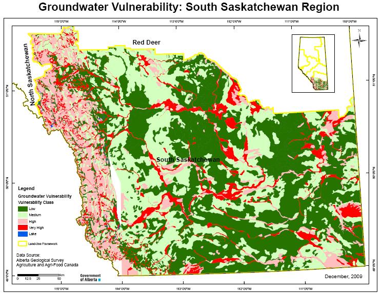
16 Groundwater Management Policies and Tools Policy Support to Regional Plans (Land-use Framework) Support development of regional cumulative effects management capacity Develop Groundwater Management Units as a watershed management option. Provide screening tool to assess regional risk of contamination to shallow groundwater Groundwater Vulnerability Mapping One of many GIS risk layers
17 Support to Regional Plans (Land-use Framework) Groundwater Vulnerability Mapping Provide a regional description of the potential relative risk of shallow groundwater contamination from surface activity Regional scale can only be used as a screening tool to identify areas where more focused study, mapping or investigation may be warranted NOT for making local land use decisions!
18
19 Improving Stewardship

20 Improving Stewardship Working Well Community based, hands-on workshops for well owners Learn basics of groundwater, well construction, common well problems and best management practices Partnership Alberta Environment Alberta Agriculture and Rural Development Agriculture and Agri-Food Canada Alberta Health Services Alberta Water Well Drilling Association Leduc, Brazeau & Yellowhead counties


21 Improving Stewardship Working Well 57 workshops since municipalities Over 1600 participants
22 Improving Stewardship Working Well
23 Improving Stewardship Groundwater Observation Well Network GOWN started in 1956 with wells in Drayton Valley, Leduc and Milk River currently over 250 active wells across the province measurement of groundwater levels over time groundwater quality sampling

24 Milk River West GOWN Well
25 Groundwater Levels ~ 200 of the GOWN wells monitoring water levels all equipped with special data-logger equipment hydrographs available on AENV website 19 sites with near real time telemetry
26 GOWN - Near Real Time
27 Groundwater Hydrographs search for GOWN on
28 Groundwater Quality Sampling about 165 of the GOWN wells sampled wells sampled every year, 5 year rotation sampled for dissolved constituents and gas focus on shallow wells in results on renewed State of the Environment website
29 Improving Stewardship State of the Environment Reporting current State of the Environment website being updated includes air, land, water and biodiversity indicators groundwater indicators include: nitrate in groundwater methane gas in groundwater water well density groundwater quality indicators based on GOWN data
30
31 Questions? Contact: