Environmental Review (2009)
|
|
|
- Clifford Banks
- 5 years ago
- Views:
Transcription
1 Environmental Review (2009) Purpose As the population increases and development of vacant and agricultural land continues, it becomes more important to consider the effects of this growth on the natural environment. The physical features of the land place limitations on its future development potential. When determining future land uses of an area, these environmental characteristics need to be considered to ensure the land uses are suitable for the land. When development exceeds the capacity of the land, environmental hazards such as flooding, septic system failures, and severe erosion can occur. This Element looks at the major physical characteristics of the land that affect its development potential including: Geology Soils Topography Climate Hydrology Drainage Basins Stream Corridor Preservation 100-Year Floodplain Air Quality ER-1
2 Noise Potential Contamination Stormwater Treatment Geology There are no known faults in the City limits. The surface rocks in Johnson County are from the Pennsylvanian System. Limestone is the most important geological resource in Johnson County. Soils Important aspects of soils for land use planning are: Suitability for urban development The major limitations for development in Overland Park are a high shrink-swell potential, shallow depth to bedrock, and slow soil permeability. These limitations can be overcome by special design and construction practices, which increase the cost of development, but are not major obstacles to development. Suitability for on-site septic systems Favorable soil properties and site features are required for properly functioning septic systems. In general, the soils in Overland Park have been rated by the NRCS to have severe limitations for septic systems. In many cases, a special design is required for a properly functioning absorption field. General soil categories provide a basis for comparing the potential of large areas for general kinds of land uses. ER-2
3 The four general soil types in Overland Park include: Sharpsburg-Oska Northern area of Overland Park, approximately north of 95 th Street Moderately sloping Main limitations for urban uses: Shallow depth to bedrock, which influences how difficult excavations for construction will be Slow permeability, which affects the amount of storm water runoff and potential erosion Polo-Oska Southern area of Overland Park, south of 95 th street Moderately sloping Deep and moderately deep Main limitations for urban uses: High shrink-swell potential can cause damage to building foundations, roads, and other structures unless special designs are used. Polo-Grundy Higher ridgetops in southern Overland Park Gently and moderately sloping on narrow ridgetops and upper side slopes Main limitations for urban uses: High shrink-swell potential ER-3
4 Slow soil permeability Kennebec-Chase Floodplains along Indian Creek, Tomahawk Creek, Negro Creek, and the Blue River Nearly level soils typically found on floodplains and low terraces Subject to frequent flooding, which is the main limitation for urban uses Topography The major planning issue with topography is slope. The slope of an area greatly affects its development potential and possible land uses. Slopes between 0 and 5 percent are considered excellent for all types of development. Slopes of 5 to 12 percent are better suited for residential and some specialized commercial development. Slopes greater than 15 percent are considered severe for development, with development becoming more difficult and expensive. Characteristics of the topography include: Ridgetops and valley bottoms generally having less then 5 percent slopes Side slopes generally having from 5 to 15 percent slopes with only small areas having steep slopes, greater than 15 percent Steep slopes are located along stream banks Area located in the Central Lowland Province of the Interior Plains ER-4
5 Gently rolling and undulating uplands containing the Blue River Valley and its tributaries Part of the Osage Cuestas physiographic region, which is a landscape characterized by: Parallel ridges generally running east to west, with steeper slopes on the southern sides of the valleys The Indian Creek, Tomahawk Creek, and Blue River valleys Elevations in Overland Park range from 1,080 feet on the ridgetops in the southern areas of the City to 850 feet in the Turkey Creek and Indian Creek valleys, as they exit Overland Park. Climate A continental type climate, which is characterized by wide daily and annual variations in temperature Average daily temperature is 54.2 F, with July the warmest month and January the coldest Average January temperatures are; High 38 F, Low 20 F Average July temperatures are; High 89, Low 69 F Average annual precipitation is inches, with 70 percent of the total occurring from April to September On average there are 59 days per year with at least.1 inches of rain Average annual snowfall (including pellets and sleet) is 19.9 inches Prevailing wind from the south, with an average annual wind speed of 10.6 mph Future Climate According to a 2009 report Global Climate Change Impacts in the United States a report prepared by the ER-5
6 United States Global Climate Change Research Program (USGCRP) coordinating the work of 13 federal agencies, the climate of the Kansas City area is expected to change in the future. Projections for the Kansas City area for the end of century (2080 to 2099) include the following; 6 to 10 F increase in average summertime temperatures 5 to 10% increase in winter precipitation averages 15 to 20% decrease in summertime precipitation averages Increase in high intensity storm events (no ranges provided in report) Hydrology The hydrologic cycle is the transport of water from the atmosphere to the land via precipitation which drains to ever larger bodies of water by surface and sub-surface drainage and returns to the atmosphere via evaporation. In developing areas, like Overland Park, an important part of this cycle is storm water drainage. Undeveloped areas: The natural drainage system consists of intermittent and perennial streams that eventually receive the stormwater runoff. Undeveloped areas have, by their nature, more permeable surface, allowing for higher rates of storm water infiltration and filtering. Developed areas: Increased amount of impermeable surfaces These are surfaces that do not allow infiltration of water. Impermeable surfaces increase the amount of runoff. ER-6
7 Increased runoff can overwhelm the natural drainage system and cause flooding and/or erosion. Impermeable surfaces contribute to the degradation of surface water quality. Storm sewers, natural stream buffers and protected floodplains are necessary to augment the natural drainage and reduce the risk of flooding. Stormwater Systems: Natural Drainage channels Approximately 224 miles of natural streams are located within the City with a drainage area exceeding 40 acres. Storm sewers Need to be maintained and upgraded to handle the increased runoff as development continues As of 2008, approximately miles of improved publicly maintained storm sewers and miles of privately maintained storm sewers are located within the City. As of 2008, there are 18,518 publicly maintained storm sewer structures such as manholes and curb and area inlets. Stormwater runoff issues: Runoff directly affects water quality. Storm sewers empty directly into the natural surface water drainage with no treatment unless the development is required to comply with the City s Stormwater Treatment Ordinance. Runoff from streets and parking lots can transport contaminants, which could degrade the water quality if left untreated. ER-7
8 Overland Park is currently required to address water quality from stormwater as part our NPDES (National Pollutant Discharge Elimination System) municipal stormwater permit with KDHE (Kansas Division of Health and Environment). This permit requires that we implement programs to improve water quality in each of six areas. The City has developed a Stormwater Management Plan to address these minimum measures. Public education The City has implemented a public education program that includes message development and media distribution in the community; Public involvement The City has solicited public comment and recommendations regarding best management practices and measureable goals with regard to water quality; Detection and elimination of illicit discharges to our system The City has developed, implemented, and currently enforces a program that detects and eliminates illicit discharges within the community; Erosion, sediment, and pollution controls from construction sites The City has developed, implemented, and currently enforces a program that reduces pollutants in stormwater runoff from construction activities; Controls and treatment for runoff from new development sites after construction The City has developed, implemented, and currently enforces a program that reduces pollutants from stormwater runoff by requiring permanent best management practices to be constructed for new development and redevelopment; and Good housekeeping in our own municipal operations The City has developed and implemented an operation and maintenance program that prevents and reduces stormwater pollution from municipal operations. ER-8
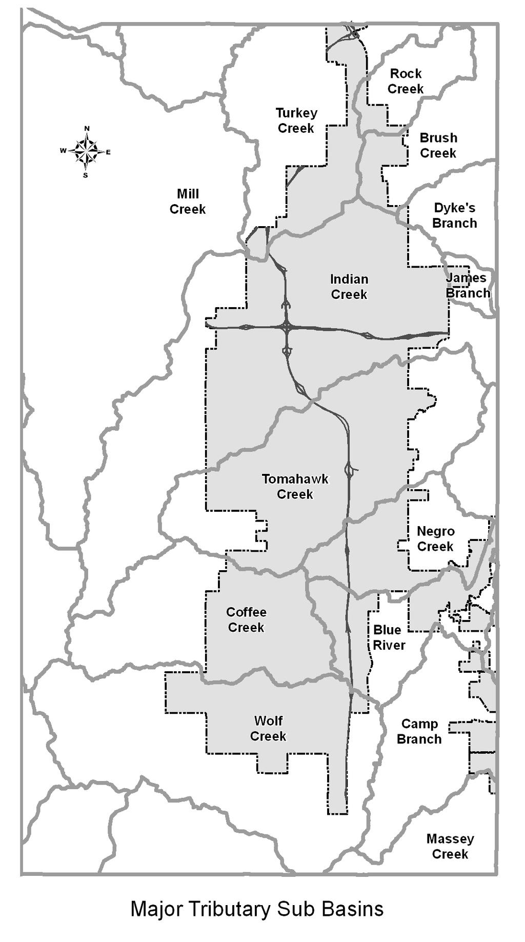
9 Surface water in Overland Park is not utilized locally as a water supply. Our surface waters drain to the Missouri River, which acts as a water supply for downstream communities. Flooding Storm sewers and proper site grading prevent flooding in the immediate area of their use. Storm sewers can contribute to downstream flooding because the runoff from a storm sewer system reaches the natural drainage channels much quicker. The entire drainage basin should be studied to understand the impact of a storm sewer system. Watershed studies have been completed on all major basins within the City. Detention Basins Detention basins are man-made structures that serve as a means of temporarily storing stormwater runoff. Under specific conditions, detention basins can provide runoff control and reduce the flooding potential. The City instituted a policy on detention basins in the mid-1980s and required them in areas where downstream flooding problems have been indentified. Future development within Overland Park must consider detention basins in areas where downstream flooding problems have been indentified. Drainage Basins A drainage basin for a stream includes the area of land that drains into the stream. The boundaries of a drainage basin are drainage divides. They divide the land into drainage basins, with all land inside a divide draining into that basin. Small drainage basins (sub basins) are part of large drainage ER-9
10 basins (major basins). The management of surface water resources is most effective when entire drainage basins are considered. Drainage basins are natural features, and do not stop at political or legal boundaries. All of the sub basins located within Overland Park extend beyond the City limits, with many of them extending upstream of Overland Park. Changes that occur in a drainage basin will affect the entire basin, especially the downstream areas. An important characteristic of a drainage basin is the type and acreage of land uses within the basin. Changes in land use affect the amount of stormwater runoff in the basin, which affects the stream flow and flood hazard area in the basin. As development increases, the amount of impermeable surface increases. As the amount of impermeable surface increases, the volume and rate at which runoff reaches the drainage channel increases. The acreage of undeveloped land in a drainage basin is an indicator of the potential amount of impermeable surfaces that could result from land use changes and urbanization in the basin. Heavily developed basins have little potential for additional impermeable surfaces and the resulting increase in the amount of stormwater runoff. Undeveloped basins have the potential for a large increase in the additional amount of area covered by impermeable surfaces. Increase in impermeable surfaces will increase the amount of stormwater runoff in the basin and could greatly increase the flood hazard in downstream areas. ER-10
11 Overland Park is located within the upstream areas of three major drainage basins: Kansas River Basin The only sub basin in Overland Park that is in this basin is the Turkey Creek Basin. The Kansas River Basin drains to the north of Overland Park. Blue River Basin Nearly all other sub basins in Overland Park are in the Blue River Basin. The Blue River Basin drains to the east of Overland Park. The headwaters of the 272 square mile Blue River Basin lie to the southwest of Overland Park. Overland Park encompasses approximately 25.7% of the entire Blue River Basin. Marais des Cygnes Basin Overland Park encompasses only 54 acres (.08 sq. miles) of the Marais des Cygnes River basin, which covers 7,008 square miles within east-central and southeast Kansas, and west-central Missouri. The Marais des Cygnes Basin drains to the south of Overland Park. The only sub basin in Overland Park that is in this basin is Massey Creek. There are parts of fourteen separate sub basins located in Overland Park that are part of the Kansas, Blue, and Marais des Cygnes Basin River Basins. Table ER-1 summarizes comparative sizes, floodplain information, and the level of development within each sub basin. The information on the level of development is based on currently available data from ER-11
12 ER-12
13 Table ER 1 Drainage Basins in Overland Park River Basin Sub Basin Total Acres % of City Floodplain Acres Total Acres % of City Floodplain Acres Vacant Acres Dev. Acres % Dev % Dev % Dev Kansas River Turkey Creek 3, % , % , Mill Creek % % Blue River 3, % , % , , Brush Creek 1, % 0.2 1, % , Camp Branch 1, % % Coffee Creek 4, % , % , , Blue River Dyke's Branch % % Indian Creek 14, % 1, , % 1, , James Branch % % Negro Creek 3, % , % , Rock Creek % % Tomahawk Creek 10, % , % , , Wolf Creek 5, % , % , Marais des Cygnes Massey Creek % 0.0 City Total 48, % 3, , % 3, , ,469.6 NOTES: (1) The percentage of developed land in 2009 (% Dev. 2009), is unavailable at this time. (2) In 2007, the city limits of Overland Park were not in the Marais des Cygnes River Basin. ER-13
14 Development influences: Increased development in the upstream areas of a drainage basin will affect the amount of storm flow in the downstream areas of the basin. Land use changes in Lenexa and Olathe will affect Overland Park, due to their locations upstream of Overland Park in more than one drainage basin. Land use changes in Overland Park will affect areas downstream in the Blue River Basin. Development patterns: Most of the development in the City is occurring in the Tomahawk Creek, Negro Creek, Coffee Creek, and Blue River drainage sub basins. As of 2009, the Coffee Creek, Wolf Creek, and Blue River drainage sub basins still have a great deal of development potential. Even though the Indian Creek, Tomahawk Creek and Negro Creek drainage sub basins are over 87% developed, there is still a large amount of land (over 2,100 acres) to be developed due to the sizes of those basins. Stream Corridor Preservation In October, 2003, the City of Overland Park adopted an ordinance to dedicate and protect specific areas adjacent to streams that are designated as stream corridors. By reducing and controlling runoff, stream corridors serve as an important component in the overall stormwater management program. Use and development of the land within a designated stream corridor is limited and defined within the ordinance. ER-14
15 Limits of the stream corridor are established based upon the drainage basin size and range from 15 feet to 120 feet beyond the ordinary high water mark on each side of the stream. As of 2009, a total of 1,241.2 acres of vacant land have been identified as potential dedicated stream corridors that will be protected under the City ordinance as development occurs. The amount of potential dedicated stream corridors located within the eight basins is as follows: Acreage of Potential Stream Buffer (in each Basin) Turkey Creek 11.9 Brush Creek 0.0 Indian Creek 79.4 Tomahawk Creek Negro Creek 42.0 Coffee Creek Blue River Wolf Creek Camp Branch 76.8 Total 1,241.2 To date (July, 2009), 45 separate projects encompassing 203 acres and 11.0 miles of streams have dedicated stream corridors as part of their development approval. Additional areas will be covered by future agreements as development continues. Prior to adoption of the Stream Corridor ordinance, a large number of stream corridors had been preserved. These corridors were either: Part of a river system large enough not to require enclosure in storm drainage systems; Granted a variance from storm drainage rules; or Accepted into public ownership as parkland. In addition, there are areas in the older portions of the City and in annexed regions that were developed at a time when requirements to build storm ER-15
16 sewers were not in place, and therefore have a residual system of natural streams or ditches. In many of these cases, the buffer zones provided to such natural streams are smaller than what is provided under the ordinance, and concerns for stream bank erosion and stability exist in portions of these areas. Stormwater Treatment In November of 2007, the City of Overland Park adopted a stormwater treatment ordinance to protect our local stream, lakes, ponds, and groundwater from the adverse impacts of urban development. The ordinance was adopted in order to comply with the City s National Pollution Discharge Elimination System (NPDES) Permit and EPA requirements. In urban areas, runoff from rain or snow has the potential to pick up soil, pet waste, salt, pesticides, fertilizers, oil, grease, litter, and other pollutants that can wash off into our streams, rivers, and ponds. The program aims to implement more natural stormwater systems such as rain gardens, bioretention cells, native vegetation swales, etc. that treat pollutants before entering the City s waterways and provide community and water quality benefits. All new development plans that disturb more than 1 acre of land are required to provide stormwater treatment facilities for their site. Any expansion or redevelopment plans that are submitted for a site that has previously been developed are required to provide stormwater treatment facilities for the new impervious surface only. To date, 11 projects have been submitted and approved that include stormwater treatment facilities. ER-16
17 100-Year Floodplain The damage caused by flooding can be devastating and cost large sums of money and possibly the loss of life. Major flooding has occurred in Johnson County and surrounding areas and large sums of money have been spent to control the flood hazard in some areas. Flooding and flood damage in Johnson County has occurred mainly in urbanized areas where development has greatly increased the amount of stormwater runoff and where development has occurred in the floodplain. Flooding in basins: Turkey Creek, Brush Creek and Indian Creek have all experienced significant flooding. Located in northern Overland Park Heavily developed The remaining basins in Overland Park have not experienced the same amount and scope of flooding. Located in southern Overland Park Not as heavily developed Where development has occurred or will occur, potential for future flooding is reduced because more stringent development standards are in place, and because watershed-wide flood studies are available to better guide development decisions. Flood standards: The Federal Emergency Management Agency (FEMA) has adopted the 100-year flood as the base flood for floodplain management purposes. The 100-year flood is the flood that has a 1% chance of happening in any given year. ER-17
18 The 100-year floodplain indicates areas that would be inundated by the base flood. The base flood regulated by FEMA is based on existing levels of development in a given watershed. The base flood can be expected to change as a given watershed continues to develop. The City of Overland Park also considers future increases in flood elevations based on future development patterns when approving development plans. A flood insurance study of Johnson County was originally conducted by FEMA during the 1970 s. The City originally adopted flood insurance rate maps (FIRM) and a floodplain ordinance in The flood insurance study and associated mapping was revised several times in the 1980s through early 2000 s incorporating improved data as it became available. A portion of that study was revised in 2002 to incorporate the results of the Tomahawk Creek flood study. The flood insurance study and flood insurance rate maps (FIRM) for the entire county was revised effective August 3, 2009 to incorporate the watershed studies completed for all other basins in Overland Park. General information: The 2009 flood insurance rate maps identified 3,421.8 acres of 100-year floodplain in Overland Park, 7.1% of Overland Park. Over 70% of the 100-year floodplain was located within three drainage basins. Indian Creek sub basin, 31.2% Blue River sub basin, 23.0% Tomahawk Creek sub basin, 15.9% ER-18
19 Technical information: Technical analysis was done separately for each drainage basin. The 2009 FIRM maps are based on comprehensive watershed studies completed between 1997 and Peak discharge was determined for selected points along the streams for a combination of design storms under existing and future development scenarios. The 10, 50, 100, and 500 year storms were modeled. Stream channel cross-sections at those points were used to determine the capacity of the stream channel and surrounding floodplain. Peak discharge and capacity of the stream were compared at each point to determine the water surface elevation and extent of the floodplain at peak flow for each design condition. FIRM maps are based on existing level of development and the 100-year storm. As Overland Park continues to develop, the limits of the regulatory floodplain will continue to change. Overland Park requires development to consider both existing and future anticipated flood levels for flood protection requirements. Drainage studies: Tomahawk Creek Study In 1994, a study of the Tomahawk Creek Drainage Basin was proposed as a way to determine the ultimate 100-year floodplain for Tomahawk Creek, as well as update the existing 100-year floodplain. The study was completed in 1997 and later incorporated as the Flood Insurance Rate Map in Blue River Study (Includes Blue River, Negro Creek, Coffee Creek Wolf Creek, and Camp Branch sub basins) ER-19
20 The Blue River Study was initially completed in An addendum to the study was completed in December 2005 to correct some inconsistencies in the original study and perform additional study of the main stem of the Blue River in the vicinity of 151 st and Kenneth Road. The Blue River study was incorporated into the Flood Insurance Rate Map update scheduled for adoption on August 3, Indian Creek Study The Indian Creek study began in 2001 and was completed in The study was funded 100% by Johnson County, but the City of Overland Park acted as the project manager and directed the engineering consultant in their work. In this way, the City was able to bring its greater familiarity with flooding issues in this basin to the work. The Indian Creek study was incorporated into the Flood Insurance Rate Map update adopted on August 3, Northeast Johnson County Floodplain Study (Includes Brush Creek, Rock Creek, Turkey Creek, and Dykes Branch sub basins) The Northeast Johnson County Floodplain Study began in 2001 and was completed in The study includes results for four basins within the City, the Turkey Creek, Rock Creek, Brush Creek and Dykes Branch sub basins. Fifteen cities are included in the Northeast Johnson County Floodplain Study. The cities with significant land area included in this study include Overland Park, Merriam, Mission, Mission Hills, Roeland Park, Fairway, and Prairie Village. Five of the watersheds in Northeast Johnson County were analyzed in this study, including Turkey Creek, Rock Creek, Brush ER-20
21 Creek Dyke's Branch and Lake Quivira. The analyses of these watersheds include over 38 miles of land, approximately 50 miles of stream, and nearly 250 culverts and bridges. Public Input Public meetings were held at the beginning of all watershed studies to inform property owners about the project and obtain information on existing flooding history. Two rounds of public notifications of the flood study results were made to impacted property owners between 2006 and In addition, a special public meeting for the Indian Creek basin was held in October Air Quality The National Ambient Air Quality Standards (NAAQS), established by the U.S. Environmental Protection Agency (EPA), define the maximum allowable concentrations of pollutants that may be reached, but not exceeded, in a given time period to protect human health and welfare. Air quality is more complicated than most environmental issues and the results of failing to meet air quality standards can be far reaching. A failure to meet air quality standards is undesirable for a variety of reasons including: Increased health risks for area residents Ozone pollution is linked to respiratory and cardiac problems, especially in young children and the elderly. Additional regulation of local industry If the ozone concentration is high enough, the permitting process for new and existing industry could be affected. Could limit the region s ability to attract new industry and jobs ER-21
22 Possible reduced transportation funding Other federal sanctions Following changes to allowable ground-level ozone standards that occurred in 2004, the Mid-America Regional Council prepared a Clean Air Action Plan (CAAP) that contains voluntary strategies for reducing air pollution. The CAAP has four primary components: Reduction of emissions from existing power plants in the region Diesel exhaust emissions improvements Public education Sustainability Mid-America Regional Council coordinates an extensive public education program that focuses on steps individuals and businesses can take to reduce air pollution. Despite voluntary efforts, all of Greater Kansas City will very likely be classified as non-attainment for air quality standards beginning in March 2010, which means that the area does not meet the required air quality health standards established by EPA for one or more of the six criteria air pollutants: lead particulate matter nitrogen oxides carbon monoxide sulfur dioxides ground-level ozone The Kansas City region, which consists of Johnson and Wyandotte Counties in Kansas, and Clay, Jackson, and Platte Counties in Missouri, violates the ground level ozone standard. ER-22
23 The State of Missouri has recommended that Clinton and Cass Counties be added to the region as well. The national ozone standard was made more restrictive in 2008, when the standard was lowered from 80 parts per billion (ppb) to 75 ppb. This is a three-year average, based on observed monitoring data from around the region. There is one monitor in Johnson County, located in Heritage Park. The three year average ( ) for ozone in Johnson County is 69 ppb. Higher levels that have caused the metropolitan area to violate air quality standards are found at monitors north northeast of the City, primarily due to prevailing south and southwest winds during the summer months. Monitors in these areas have exceeded both the previous and new standard. Based on the three year average from , monitors that have violated the standards include: Liberty - 80 ppb Rocky Creek 81 ppb Clinton County 79 ppb Watkins Mill - 77 ppb Motor vehicle emissions are the greatest contributor to groundlevel ozone pollution in Kansas City. Once the Kansas City area is designated a non-attainment area, the State of Kansas will be required to develop a State ER-23
24 Implementation Plan (SIP) and meet the new standard within 3 years of EPA approving the plan. The SIP for Kansas has not been developed, but will include new idle reduction regulations for heavy-duty diesel vehicles (to be implemented Fall 2009), and may include new regulations on power plants and new requirements for industries that emit nitrogen oxides. Noise Noise is sound that disrupts normal activities, or otherwise diminishes the quality of the environment. Acceptable noise levels differ between different land uses. Overland Park regulates noise generated by various land uses through zoning. Major sources of noise are airports, highways, and industries. Johnson County Executive Airport is located near the southwestern City limits. The second busiest airport in the State of Kansas May be expanded in the future with a longer runway The land uses in areas adjacent to the airport in Overland Park are residential and undeveloped/agricultural. Interstate 435 runs through the center of Overland Park from east to west. Current traffic volumes on Interstate 435 range from over 121,000 to 136,000 vehicles per day. US 69 traverses the City from north to south starting at 87th Street. ER-24
25 Current traffic volumes on US 69 range from 24,000 to 87,000 vehicles per day. Interstate 35 runs along the northwestern border of Overland Park. Current traffic volumes range from 109,000 to 159,000 vehicles per day. The Kansas Department of Transportation has been installing noise barriers along those sections of I-435 and US 69 that adjoin residential developments where noise levels warrant barriers and when major improvement projects are constructed. Potential Contamination Potential sources of contamination can include: Leaking underground or above ground storage tanks Illegal dumping Underground pipelines Some contaminated sites in Johnson County are on national lists, but no currently listed sites are located within Overland Park. The Kansas Department of Health & Environment, Bureau of Environmental Remediation has identified active sites in Overland Park where remediation activities are currently ongoing. Summary The majority of these sites are current or former dry cleaners. Environmental factors influence the potential land uses for an area. Overland Park has few environmental constraints to development, but as development increases, and areas without environmental constraints are no longer available for development, the potential for environmental hazards will also increase. Examples include increased flooding, nonfunctioning ER-25
26 septic tanks, and development on marginal land (severe slopes over 15 percent). The potential for development of the southern areas of Overland Park is high, but the effect on the environment needs to be considered in future development plans. It is for this reason that the City initiated the study of the Tomahawk Creek Drainage Basin and has participated with the county, as needed in the study of the other drainage basins in the City. In the future, development on marginal land can be avoided through flexibility in subdivision design offered by such districts as RP-OE, Planned Open Space Estate Residential District and RP-OS, Planned Open Space Single-Family Residential District. Flexibility in the design of a multifamily project also makes the preservation of environmentally sensitive lands possible. Typically, nonresidential developments require large level sites to accommodate parking and building footprints so the desire to develop on environmentally sensitive land is less likely. As with multifamily developments, nonresidential developments can to some extent transfer densities to the developable portions of a property, thus avoiding floodplains and other environmentally sensitive land. The stream corridor ordinance adopted in 2002 also provides substantial protection to riparian areas, which are important for ecological preservation but marginal for development. Given this and the other policies discussed above, the City is in a good position to continue development while remaining sensitive to the environment and potential hazards. ER-26