TOWN OF CARRBORO NORTH CAROLINA STORMWATER UTILITY RATE STUDY
|
|
|
- Andra Walters
- 5 years ago
- Views:
Transcription
1 TOWN OF CARRBORO NORTH CAROLINA STORMWATER UTILITY RATE STUDY June 6, 2018 BOARD OF ALDERMEN LYDIA LAVELLE, MAYOR BETHANY CHANEY, ALDERWOMAN BARBARA FOUSHEE, ALDERWOMAN JACQUELYN GIST, ALDERWOMAN RANDEE HAVEN-O DONNELL, ALDERWOMAN DAMON SEILS, ALDERMAN SAMMY SLADE, ALDERMAN STAFF DAVID ANDREWS, TOWN MANAGER ARCHE MCADOO, FINANCE DIRECTOR JOE GUCKAVAN, PUBLIC WORKS DIRECTOR RANDY DODD, STORMWATER UTILITY MANAGER 1
2 TABLE OF CONTENTS Executive Summary Carrboro s Stormwater Management Program Program Structure Program Challenges Limited Funding/Capacity Regulatory Requirements Program Opportunities Five Year Plan for Expansion of Services Stormwater Advisory Commission Stormwater Management Cost Projections Introduction Cost Projections Fee Analysis and Recommended Rate Structure Introduction Analysis Identifying Non-Exempt Properties Assigning Properties as Residential or Nonresidential Impervious Surface Analysis Recommended Rate Structure Implementation Process Appendices Appendix 1 Glossary Appendix 2. Carrboro s Current Stormwater Management Program Appendix 3: Stormwater Utility Fees in NC (From UNC-EFC) Appendix 4: Maps of Non-Exempt Parcels Appendix 5: Summary of Identified Capital Projects/Retrofits Appendix 6: FAQs Appendix 7: Links to additional information
3 List of Figures Figure 1: Moving from Utility Establishment to Operation Figure 2: Nonexempt Parcels Subject to Stormwater Fee Figure 3: Impervious Area for Residential Parcels Figure 4: Impervious Area Tiers for Nonresidential Parcels Figure 5: Timeline for Rate Structure Adoption List of Tables Table 1: Administration of Stormwater Services Prior to and With the New Stormwater Utility... 6 Table 2: Summary of Town Staff Current Major Stormwater Responsibilities... 7 Table 3: Comparison of Carrboro, Chapel Hill and Hillsborough Stormwater Utility Capacity... 9 Table 4: NPDES Permit New Activities Table 5: Summary of Current Structural Stormwater Control Measures in Carrboro Table 6: Stormwater Utility Recommended Plan for Phasing in of New Services* Table 7: Three Year Stormwater Program Budget Presented in June, Table 8: Five Year Stormwater Program Cost Projection Table 9: Town Code Stormwater Utility Definitions Table 10: # of Non-Residential Properties by Tier Table 11: Recommended Rate Structure Table 12: Complete Non-Residential Rate Structure
4 Executive Summary The Town is in the process of establishing a Stormwater Utility that recognizes that stormwater runoff is a community wide problem and that the Town s current stormwater program is not sufficient to comprehensively address the needs. The purpose of this study is to recommend a rate structure as an important next step for funding the stormwater program and formally establishing the Utility. The basis for the recommendations provided are: Carrboro's Town Code, which provides the legal structure; federal and State regulatory requirements; anticipated expenses for the utility; a GIS study of impervious surfaces in Carrboro; and experience from other North Carolina jurisdictions that have implemented utilities. The recommended rate structure is a "hybrid" with a flat fee for single family/small residential properties and a tiered structure for nonresidential properties. The nonresidential rate structure, while tiered, is a direct extrapolation from the residential rate based on amount of impervious surface for a given property. The rate structure is based on the amount of impervious surface relative to the Equivalent Residential Unit (ERU) of impervious surface. The premise is that impervious surface is an appropriate metric for determining the impact of stormwater runoff from a given property, consistent with practices across North Carolina and the United States. The recommended rate will support annual gross revenue from fees of a little more than $800k, which will meet operating requirements with a surplus for future capital expenses. An important factor in recommending this rate structure is balancing the level of administrative overhead with the more discrete fees that can be assigned with more accurate and precise but more administratively intensive data. Public meetings and other means of outreach were pursued to notify the community of the proposed rate structure and fees, and a public hearing held. An Interlocal Agreement with Orange County was developed to allow the Orange County Property Tax Office to provide billing support. The associated fees will be included in property tax bills sent out in the summer of
5 1. Carrboro s Stormwater Management Program The purpose of this section is to describe the expansion of Carrboro's stormwater management program that is enabled by the forming Stormwater Utility; the Town s stormwater program through mid 2018 is described in more detail in Appendix 1. The Utility will allow Carrboro to better address current regulatory requirements, prepare for potential future requirements, and in general expand stream and watershed protection and restoration initiatives, support for property owners with flooding and drainage related impacts, and maintenance and enhancements of stormwater infrastructure. 1.1 Program Structure Carrboro s stormwater program can be described and broken down in different ways, one of which is based on the services that the program offers (see graphic, and Table 1). It is important to consider these services not as discrete and separate, but as integrated and coordinated, as facilitated by the administrative role. The placing of the program under the umbrella of a utility and within a dedicated enterprise fund results in the ability to more holistically manage and coordinate the Town s stormwater program. Stormwater Utility Administration includes developing and implementing program service delivery; stormwater related data management; regulatory tracking and annual reporting; issuing notice of violations; contract administration for contractual services; staffing the Stormwater Advisory Commission; program integration with Town administrative activities (e.g., operating budget and CIP). Stormwater Infrastructure Services include maintenance of Town-owned stormwater system including inlets, catch basins, pipes, ditches, and Stormwater Control Measures (SCMs); street sweeping; design and construction of public stormwater infrastructure (including green infrastructure) projects, stormwater retrofits, and restoration projects on Town maintained land. Stormwater Planning Services include planning and engineering review and oversight of new development proposals and construction, and updating of the Land Use Ordinance. Stormwater Community Services includes education and outreach, providing public participation opportunities, coordination with the Clean Water Education Partnership (CWEP), and creating and implementing a drainage assistance program. Stormwater Field Services include inspections of SCMs issued under a Town land use permit, illicit discharge detection and elimination activities, stream determinations, and stream monitoring. 5
6 Table 1: Administration of Stormwater Services Prior to and With the New Stormwater Utility Stormwater Service Prior to Utility With Utility Administration Legal LUO (Article XVI) and illicit discharge (Town Code) Legal structure for Utility added in Town Code. Programmatic Dispersed program Umbrella program Financial Stormwater expenses not tracked Tracked, under Enterprise Fund Regulatory Responsibility Planning (town wide), Public Works (PW facility) Stormwater Utility Advisory Commission EAB Stormwater Commission Infrastructure MS4 1 and facility maintenance Public Works Public Works: support from Stormwater Utility Green infrastructure Not applicable Stormwater Utility Field Planning Department Stormwater Utility Planning Plan review, erosion control, permitting Planning Department: contract engineering & county support Planning Department: Stormwater Utility, contract engineering & county support SCM Inspection & Planning Department maintenance 2 Community Drainage assistance Not applicable Stormwater Utility Outreach/education Planning Department Stormwater Utility Stormwater Utility (potentially with contract support) All of these services are important for the stormwater utility moving forward. In 2018, the priority is on establishing the administrative capacity and mechanisms to operate a successful utility over the long term. The rate structure presented in this report has been a major emphasis. 1.2 Program Challenges Limited Funding/Capacity The fundamental stormwater management challenge currently facing the Town is the absence of sufficient and dedicated funding; stormwater related activities currently compete with all Town functions provided for through General Fund revenues. One ramification has been limited staff capacity. Recognizing this, the Town created a Stormwater Enterprise Fund and the legal foundation for a Stormwater Utility, and hired a Stormwater Utility Manager in Currently, this fund is not receiving a separate/dedicated revenue stream. The creation of the new Stormwater Utility Manager position is a very positive step, but additional 1 Municipal separate storm sewer system 2 This item refers to stormwater control measure inspection and maintenance on private property after development (post construction). 6
7 staff will be required in the future given the amount and diversity of work involved in implementing a comprehensive stormwater program (see Tables 2 and 3). Table 2: Summary of Town Staff Current Major Stormwater Responsibilities Type of Service Specific Responsibility Notes Administrative Launching utility Following up on this study; community input; creating and implementing interlocal billing agreement Stormwater related databases GIS and administrative databases NPDES permit administration Compliance activities, tracking and annual reporting Jordan Lake Rules Compliance tracking, planning, implementation, reporting Town administrative tasks e.g. financial, legal, contractual, cross Contract administration department coordination e.g., benthic monitoring; Public Works facility permit compliance; engineering services Infrastructure Stormwater conveyance system Maintaining catch basins, pipes, ditches, swales and proper disposal of waste from clean-up operations Planning Field Community Street sweeping Public Works facility NPDES permit Reviewing stormwater plans for new development proposals Stormwater Control Measure inspections Erosion control Implementing buffer requirements in LUO Illicit discharge detection Private property drainage inquiries Staffing new Stormwater Advisory Commission Education and outreach Town operates one vacuum truck The regulatory compliance aspect has received contract support. Shared by staff and contract engineering firms Currently able to only pursue reactively Delegated to Orange County; some staff administrative time for coordination Town s requirements exceed minimum state requirements, which adds to staff workload. Currently able to only pursue reactively Tracking and providing support with floodplain administration, maintenance of public conveyance system Initiated in February, 2018 Participation in the Clean Water Education Partnership As one means of assessing the Town s stormwater capacity, information from the two neighboring jurisdictions that are the most similar to Carrboro in many respects, Chapel Hill and Hillsborough, has been pulled together (Table 3). Chapel Hill has $2.8M and 16 stormwater staff positions and Hillsborough, with about a third of Carrboro s population and three quarters of the geographic footprint, has two full time stormwater staff positions and one Public Works position funded from their Stormwater Enterprise Fund. 7
8 The similarities shared by these towns includes both comparative size, proximity, demographics, etc., but also their status as Phase II NPDES communities 3 and location in the Jordan and Falls Lake watersheds, and by reference, associated regulatory requirements. Chapel Hill also shares in participation in the Bolin Creek Watershed Restoration Team with Carrboro. Utilizing contractor services has been and will likely continue to be a cost effective way to complete some tasks without adding additional staff. The largest stormwater related contractual services historically have been for engineering services. The Town has also contracted for benthic monitoring support for the past 15 years, and for support with NPDES permit compliance for the Public Works facility and some infrastructure maintenance. New contractual services, e.g., for retrofit projects and perhaps other planned activities such as new monitoring and other field work, laboratory analyses, community outreach, additional infrastructure maintenance, support with impervious surface GIS data, and other special studies are all worth considering. With all contracting, Town staff must have time to administer contracts and supervise work, which is another reason why the stormwater program needs additional staff. As a specific step forward to address the need for expanded capacity, it is recommended that a Stormwater Specialist position be planned for. The Stormwater Specialist position would provide support with: illicit discharge and pollution prevention and good housekeeping components of NPDES permits; SCM inspections and maintenance program; stormwater infrastructure and impervious surface GIS and utility billing data maintenance; supporting outreach and education efforts; completing stream determinations for new development proposals within the Town s delegated stream buffer authority and wetlands delineations; and helping initiate a Drainage Assistance Program. The position would support the Stormwater Utility Manager, Public Works Superintendent, and other staff with these and other stormwater management responsibilities. 3 The Phase II designation refers to small municipalities, generally with a population between 10k and 100k, and a population density of at least 1000/square mile. NPDES refers to National Pollution Discharge Elimination System under the federal Clean Water Act. 8
9 Table 3: Comparison of Carrboro, Chapel Hill and Hillsborough Current Stormwater Utility Capacity Carrboro Chapel Hill Hillsborough Utility Established In process Population 21,265 59,246 6,568 Area in Town (sq. miles) Utility Annual Revenue TBD 4 $2.8M $600k (approx.) Dedicated Staff Stormwater Manager 1 1 Engineer * 4 Stormwater Specialist 1 1 Stormwater Analyst 1 Environmental Educator 1 Stormwater Billing Technician 1 Mosquito Control Officer 1 Public Works staff Total 1* 16 3 *See footnote Regulatory Requirements NPDES Phase II Permits The Town is regulated under two NPDES Phase II stormwater permits, one that is town wide and one for the Public Works facility. 7 Areas of needed performance improvement during this permit cycle are summarized in Table 4. While all of the six minimum measures required in the town wide permit are being implemented to a certain degree, the illicit discharge and post-construction stormwater programs have been implemented more reactively rather than proactively. For instance, the illicit discharge program is supposed to include preventative and proactive measures such as determining high hazard areas and completing routine inspections of these areas. The post-construction stormwater program includes review of stormwater management for development projects. It also requires inspection of SCMs; there are approximately 200 in Carrboro (Table 5). That is in addition to the requirement that the SCM owner inspect and submit a report at least annually to the Town for review. Creation of the Stormwater Utility Manager position provides some additional capacity for inspections and overseeing this program, but given the other responsibilities of the position, additional staff will be needed to fully meet this regulatory requirement. 4 ~$850k is the projected annual revenue for the recommended rate structure presented in this report. It is designed to support both operating and capital expenses, including a capital reserve. 5 Maintenance Supervisor, Street Cleaning Crew Supervisor, Heavy Equipment Operator, Construction Worker 6 Carrboro does not have an engineer on staff, but uses contracting engineering services. It is estimated that the Town is currently using close to 1 FTE of contract engineering support for stormwater, although some of this is reimbursed from applicants for land use permits. 7 In March, 2017, the town wide permit was renewed, and the Public Works permit will be reissued later in
10 Table 4: NPDES Permit New Activities New Activity Administrative: annual analysis of the capital and operation and maintenance expenditures and staff resources for stormwater; potential for new annual reporting requirements and goal to create a high quality, community oriented annual report. Public Education, Outreach and Public Participation: renewed permit requires more extensive outreach and participation program. Illicit Discharge Detection and Elimination: detect dry weather flows; employee training; improved public reporting mechanism; procedures to identify and eliminate failed septic systems; Enforcement Response Plan (ERP); enforcement tracking Post Construction Runoff Control: More detailed inventory of post-construction structural stormwater control measures; recordation of maintenance responsibility; fully implement program for long-term operation and maintenance of structural BMPs, including verification of maintenance and inspections; provide educational materials and training for developers; more fully implement Enforcement Response Plan (ERP), including recordkeeping and follow-up associated with enforcement actions. Notes Additional staff time needed. Additional staff time may be needed. Additional staff time needed. Significant additional staff time or contract resources needed. 8 Table 5: Summary of Current Structural Stormwater Control Measures in Carrboro SCM Type Number Ownership Number Dry detention (flooding) 64 HOAs 55 Bioretention (aka rain garden; water 50 CHCCS 32 quality) Ponds (both flooding, water quality) 19 Other (mix of commercial, 83 multifamily, public) Other (e.g., wetlands, cisterns, underground devices) 37 Jordan Lake Rules As with the Town's NPDES permit, compliance with the Jordan Lake rules is regulatory in nature, however, the future requirements, costs, and timing of regulatory compliance has been more difficult to plan for in the past five years due to changes in State legislation. The rules could require unprecedented reduction of nitrogen and phosphorous in stormwater runoff from existing development. While the cost of the new development Jordan Lake stormwater rules is born primarily by the development community, the existing development stormwater requirements are solely the responsibility of the Town to implement. While there is some uncertainty, staff have been preparing for Stage 1 of the existing development rules, and have programmed over $4M in the Town's Capital Improvement Program. Stage 2 requirements have not been 8 Implementation of maintenance program to date based on landowner responsibility, with Town inspections, and legal authority to take over maintenance if neglected. 10
11 determined, but could result in additional expenses beyond Stage 1. 9 Retrofit projects have other benefits as well, such as improvement in local stream quality and reduced flooding impacts. Some level of pursuit of these projects is therefore recommended regardless of the future of Jordan Lake Rules. At a minimum, staff time is needed to continue to prepare the Town for potential implementation of the Jordan Lake Rules. Finally, in 2017, TJCOG, with participation by a broad stakeholder group, initiated exploration of regional collaboration. Involvement with this effort could require additional staff time in the future. Bolin Creek Watershed Restoration 10 Carrboro staff worked with Chapel Hill and other local, state and federal agency staff in 2006 to create the Bolin Creek Watershed Restoration Team (BCWRT) because Bolin Creek has been on the list of state and federal impaired waterbodies. At the time, the Bolin Creek watershed was selected as one of only 7 watersheds in the state to receive focused state and federal assistance in preparing grant applications and leveraging other resources, with a goal of improving water quality and removing Bolin Creek from the impaired waters list. This is an ambitious goal that will require a robust commitment for many years to come. To date, the progress that has been made has been grant supported, with little activity for the past 5 years. Available grant funding is currently very limited and competitive, and even with grant support, matching funds, in kind support, and staff capacity is needed. It is important to recognize that participation in the BCWRT is fulfilling a regulatory obligation since Bolin Creek has been identified as an impaired waterbody. 1.3 Program Opportunities The new Stormwater Utility and Stormwater Enterprise Fund create the following opportunities: 1) Better protection and restoration of local creeks and downstream receiving waters, including Jordan Lake 2) Expansion of green infrastructure which provides multiple environmental and community benefits 3) Better service delivery to the community, including support to property owners experiencing impacts related to flooding and drainage. 9 The Town s eventual mandatory requirements and associated costs for implementation under the Jordan Lake Existing Development rule is a complex regulatory matter that has become more complex with legislative actions in the past several years. It is the Stormwater Utility Manager s recommendation that the Town take this rule seriously regardless of state legislative action. The need for water quality restoration in Jordan Lake has been studied and debated for over 4 decades, and the Jordan Lake Rules adopted in 2009 were the result of a long scientific and engineering analysis and stakeholder process. Importantly, there is also a federal TMDL for the lake; EPA has the ability to intervene if it deems that State level action is insufficient. 10 Additional information on the Bolin Creek Watershed Restoration Team is available at 11
12 4) Better mechanisms and opportunities for community input into and support with stormwater management, in part through the new Stormwater Advisory Commission, and in part through a consolidated program with more capacity. This report discusses these opportunities to some extent. Further articulation and exploration of these opportunities and identification of new opportunities will be possible once the utility is established and fully operational. 1.4 Five Year Plan for Expansion of Services A five year programmatic plan is needed to guide cost projections, which in turn informs the new rate structure. This plan is summarized in Table 6, and corresponds to the following phases: Figure 1: Moving from Utility Establishment to Operation Phase 1 1) Stormwater Advisory Commission begins meeting 2) Review/ adopt rate structure 3) Maintain service delivery Phase 2 1)Implement rate structure 2) Update stormwater plan 3) First annual report 4) Maintain delivery of existing services and initiate new services Phase 3 1) Full service delivery: infrastructure, development, community, field, administrative 2) Initiate and pursue capital projects Phase 1 is currently underway, and is a largely administrative phase related to the establishment of the Utility. Until it is complete, Carrboro s stormwater program revenue will continue to originate from property taxes and pass through the General Fund. Phase 2 will begin as soon as a rate structure and Interlocal Agreement for billing are in place, and marks a transition from Utility establishment to Utility operation. During this transition, some continuing and new administrative activities will be required. Revenue from new fees will begin to flow into the Enterprise Fund, and service delivery for new services will begin. 12
13 Phase 3 is the fully operational stage of the Utility. The administrative pieces will be fully established, and the Utility will be able to fully delivery a range of services. Achieving this stage in a timely fashion is desirable not only from a programmatic and community perspective, but also to be well prepared for implementation of Jordan Lake Rules, which are scheduled for review within this time frame, and for demonstrating compliance with the NPDES permit and progress with Bolin Creek watershed restoration. During Phase 3, projects programmed in the Capital Improvements Plan will begin to be implemented. The following thoughts are important to highlight in considering the five year stormwater utility program plan presented in Table 6: 1) An important milestone on which the overall schedule hinges is the adoption of a rate structure and Interlocal Agreement for billing. As discussed elsewhere in this report, if either of these activities is not completed by June, 2018, the dedicated stormwater revenue stream will not be in place and the schedule and program activities could in large part be delayed by a year. 2) Similarly, hiring a Stormwater Specialist is a prerequisite for fully pursuing many if not all of the Phases 2 and 3 activities. 1.5 Stormwater Advisory Commission Part of the new stormwater program structure is a new Stormwater Advisory Commission to assist with creating and implementing the stormwater utility. Appointments were made to the Commission in January, and the Commission began meeting in February. This study has been referred to the Commission for review. Staffing the Commission and pursuing outreach related to the findings and implications of this study could be the major emphasis of the Stormwater Utility Manager in the first half of 2018 (and beyond if more work is needed to finalize the rate structure). 13
14 Table 6: Stormwater Utility Recommended Plan for Phasing in of New Services* Phase 1 Phase 2 Phase 3 Service January-June 2018 July Administrative Town Code adopted (Stormwater Utility; Enterprise Fund). Stormwater Commission formed. Stormwater Utility Manager hired. Initiated tracking of stormwater expenses. Stormwater Advisory Commission begins meeting. Rate structure developed and adopted. Interlocal Agreement with County for billing. Stormwater Specialist hired. Stormwater Plan updated. First annual report to community. Billing and revenue collection from fees begins. Regulatory annual reporting. Drainage assistance policy adopted. Jordan Lake Rules implementation anticipated NPDES permit reissued (2022) Bolin Creek Watershed Restoration Plan revisited. Community Pre 2017 efforts continue Pre 2017 efforts continue Drainage assistance program begins. Local public education/ outreach program initiated. Infrastructure Pre 2017 efforts continue Pre 2017 efforts continue Enhanced maintenance/repair and green infrastructure opportunities identified. Planning Pre 2017 efforts continue Pre 2017 efforts continue Review stormwater provisions in LUO. Field Pre 2017 efforts continue Pre 2017 efforts continue Post construction maintenance and inspection program expansion. *the timing assumes that a rate structure is adopted in FY 17/18. Drainage assistance program expands. Public education/outreach program expands Stormwater retrofit/capital projects program begins Implement any changes identified. Post construction maintenance and inspection program fully implemented 14
15 2. Stormwater Management Cost Projections 2.1 Introduction North Carolina legislation allows municipalities to charge a stormwater fee that covers only those expenditures related to the stormwater program. To determine the amount of money needed, it is essential to identify relevant current and expected stormwater expenses, and to also not include expenses that are more appropriately assigned to other Town budget accounts. Examples of stormwater specific costs include items such as: stormwater plan review for new development, inspections of stormwater control measures, illicit discharge investigations, street sweeping, maintenance of stormwater infrastructure, and stormwater capital improvement projects. A very preliminary three year budget was created for the utility in 2017 to supplement the adoption of the legal foundation in the Town Code and the FY 2017/2018 Town Operating Budget (Table 7). The basic strategy for that estimate was to focus efforts in FY 17/18 on getting the administrative structure established, transition into collecting new revenue through fees and operating the utility in FY 18/19 in; and begin implementation of capital projects in FY 19/20. Over the past five years, the Capital Improvements Program has been identifying stormwater capital projects. The CIP was most recently updated in January, 2018, and includes a 5 year plan for stormwater projects, with a need for additional projects recognized beyond this planning horizon. Table 7: Three Year Stormwater Program Budget Presented in June, 2017 Year 1 FY Year 2 FY Year 2 FY Revenues Stormwater Fees $430,000 $430,000 Transfer from G. F. $308,383 $213,658 $224,531 Total Revenues $308,383 $643,658 $654,531 Expenses Personnel $105,383 $192,797 $196,653 Operating $203,000 $450,861 $457,878 Total Expenses $308,383 $643,658 $654,531 15
16 2.2 Cost Projections From the above discussion and supporting information in this document, a five year stormwater program cost projection has been developed, using the following foundation. 1. Capture all known current operational stormwater related expenses. (In FY 17/18, Town staff began tracking stormwater specific expenses. Year to date reports were run as input into annual estimates). 2. Capture new operational expenses associated with better service for existing stormwater regulatory requirements and plan for new/potential stormwater regulatory requirements; 3. Plan for future stormwater capital projects and enhanced infrastructure maintenance, repair, and replacement; 4. Minimize administrative burden/overhead and maximize delivery of services and environmental enhancement; 5. Collect sufficient revenue to minimize future needs for rapid or significant increases in fees, and address future capital needs. 6. As discussed above, a new Stormwater Specialist staff position is recommended to provide support with delivery of services; 7. It is anticipated that approximately 3 miles of new town-maintained streets and conveyance and 20 SCMs on private property will be added due to new development during the five year period 8. The Town currently owns 6 SCMs but is planning to construct more at MLK and Anderson Park. Projections reflect both the capital costs and the expected increase in maintenance. 9. The Town has an adopted Drainage Policy. There is interest in revising this policy and establishing a new Drainage Assistance Program that could include cost sharing. 10. The projections have been used to identify revenue needed, but have not tried to discriminate between revenue funds made available through the new Enterprise Fund and the General Fund. It is important to note that the cost projections presented are best current estimates, but are not intended for final budgetary use or as firm or fixed values. The main purpose of these estimates is to provide guidance in the determination of the rates needed to deliver the desired services. The expense amounts and timing, based on future and more detailed financial analysis, can and should change as specific inputs for future operating and capital budgeting as the Utility transitions from a formative to fully operational status. The five year financial estimates are summarized in Table 8, and the following points are offered for the line items: 1) The estimates assume that a new Stormwater Specialist position is hired in December, Personnel expenses are also allocated to all service categories, with amounts varying by year. There is a shifting of allocation from more administrative time to more non-administrative time during the five year window. Non-personnel administrative expenses cover a range of items including but not restricted to dues, training, conferences, routine office expenses/supplies, vehicle use, and legal, and contractual services. 2) The Infrastructure estimates cover routine stormwater system maintenance, repairs, retrofits, street sweeping, green infrastructure, capital stormwater and stream restoration projects, and Public Works facility expenses. 16
17 3) The Planning estimates cover staff time and engineering services for development review, LUO updates, and construction oversight related to stormwater. 4) The Community estimates cover establishment of the Drainage Assistance Program and cost sharing, outreach and education, and Stormwater Advisory Commission budget. 5) The Field estimates cover SCM maintenance and inspection, benthic monitoring, stream repair materials, and cost sharing for stream gage maintenance 6) The recommended revenues from the rate structure creates a surplus to help fund capital expenses both within and beyond the 5 year window. Table 8: Five Year Stormwater Program Cost Projection* FY 18/19 FY 19/20 FY 20/21 FY 21/22 FY 22/23 Administrative Services $169,569 $141,805 $127,307 $133,743 $138,501 Infrastructure Services $163,150 $246,090 $369,110 $551,535 $520,414 Planning Services $67,650 $72,408 $74,286 $76,252 $78,309 Community Services $38,650 $66,375 $92,860 $100,575 $108,436 Field Services $30,650 $60,762 $57,439 $59,706 $61,569 Total $469,670 $587,440 $721,003 $921,811 $907,229 *personnel costs are allocated amongst the 5 service categories, with the allocation varying by year. More administrative time is expected at the start of the 5 year period, and less at the end. 17
18 3. Fee Analysis and Recommended Rate Structure Stormwater management utility shall mean an organizational structure established by the Town, that is responsible for funding, administering, and operating the Town's stormwater management program, and that is supported through a rate structure based on the impervious surface area and found on land parcels located within the town limits. Carrboro Town Code Section Introduction The above excerpt from the Town Code creates the fundamental basis for the work presented in this section. In Section 3.2, an analysis is presented that establishes the foundation for a recommended rate structure. In the Section 3.3, the recommended rate structure is presented, along with a discussion of the recommended approach to refine and improve the rate structure in future years as the utility matures, adds capacity, and is able to improve the information used to create the rate structure. An overview of elements from the Town Code that are most relevant to the rate structure is presented in Table An important contextual premise is that the analysis and recommended rate structure assumes that the Town will choose to pursue a fee basis rather than a property tax basis, as generally provided for in the Town Code. Table 9: Town Code Stormwater Utility Definitions Town Code Section Important Direction 18-3: Definitions Includes over a dozen important definitions. For example, determines how to distinguish between residential and nonresidential parcels, provides specificity for the concept of impervious surface, and defines Equivalent Residential Unit (ERU) as a unit of comparison 18-4 Utility and Enterprise Fund Establishes utility and dedicated stormwater funding; requires that revenue collected only be used for stormwater, and a Public Hearing be held prior to collecting revenue 18-5 Jurisdiction Establishes the municipal limits as the area within which the Town can collect revenue 18-6 Rate structure (Reserved) To be added after establishment of the rate structure 18-7 Schedule of fees and Establishes that rates, fees, charges, and penalties apply to charges properties in municipal limits 18-9 Exemption and credits Establishes the properties that are exempt from service charges; allows for establishment of a credit manual. 11 The complete stormwater utility section of the Town Code is available at 18
19 Given the Town s interest in social equity, it is important to point out that Section 18-9 (a) of the Town Code specifically places constraints on the ability of the rate structure to address social equity: Town Code Section 18-9(a). Statement of policy. Except as provided in this section, no public or private property shall be exempt from stormwater management utility service charges or receive a credit or offset against such stormwater management utility service charges. No exemption or reduction in stormwater management utility service charges shall be granted based on the age, tax or economic status, race, or religion of the customer, or other condition unrelated to the cost of providing stormwater services and facilities. The analysis and rate structure presented below is premised on the Town Code requirements. It also attempts to minimize the administrative burden of applying the structure, while remaining as equitable as possible to property owners. There are three basic approaches currently being used by NC jurisdictions for a fee structure 12, in increasing order of administrative complexity and need for more precise imperviousness data: 1) Flat fee. A flat fee means that the same fee is applied to all properties, regardless of any variables such as differing amounts impervious surfaces; 2) Tiered fee. This approach identifies a series of different fees for different classes of properties. Most typically, this has been applied based on a range of impervious surface areas per class, with multiple and likely many parcels falling within each tier; 3) Per unit/parcel specific fees. This approach uses the ERU or a direct estimate of impervious surface area to assign a unique fee to each parcel. To put these approaches into context for Carrboro, 4869 nonexempt parcels 13 have been identified to which a fee needs to be assigned, with imperviousness estimates by parcel ranging from 500 square feet to almost 600k square feet, or over two orders of magnitude. A single flat fee would have clear equity concerns by undercharging some and overcharging others. A tiered fee provides some middle ground, but still allows for some inequity within tier classes given the variability. A per unit fee is, hypothetically, the most equitable, but is administratively problematic due to the extra burden with developing sufficiently precise impervious surface data at a parcel scale, and an implementation burden with the effort needed to respond to questions and disputes about impervious surface estimates. 12 This article by UNC s Environmental Finance Center further discusses these: 13 This only includes properties using the 10 digit PIN. It does not include condominium properties (3 digit sub PIN) 19
20 A recurring common challenge faced by forming stormwater utilities is the significant administrative burden in determining parcel specific impervious surface estimates which are applied to calculate parcel specific fees, based on imperfect information. The rate structure that is adopted can contribute to or help alleviate this burden. With other types of public utilities, the service charge is based on metered usage. It is not practical to measure the quality and quantity of stormwater runoff from individual properties. Impervious surface area has emerged as the metric of choice for stormwater rate structures. Based on over a decade of experience in Chapel Hill 14, more precise tracking of impervious surface on individual parcels would take a concerted study initially (either in house or contracted), and a significant amount of ongoing staff time to maintain. The combination of the imprecision of GIS data and Carrboro s dense development with small lots compounds the challenge. It is recommended that as much of the revenues generated by the Utility as possible go towards solving environmental problems and serving the community, rather than meticulous tracking of impervious surfaces at a small parcel scale. In the discussion and analysis that follows, a hybrid structure that utilizes a flat residential fee and nonresidential tiers is proposed, recognizing the opportunity to change this structure in the future as more accurate and precise GIS data is developed. 3.2 Analysis This section begins with a discussion of assigning properties for inclusion in the utility ( non-exempt properties) and as residential or non-residential, and concludes with an analysis of impervious surfaces. 14 Chapel Hill has adopted a rate structure with 7 single family residential tiers, and a separate structure for condominiums and townhomes. Chapel Hill has a full time position dedicated to maintaining and administering the impervious and billing data. This does not include the billing itself, which is done by Orange County for about $50k/year. 20
21 3.2.1 Identifying Non-Exempt Properties The first step in the analysis was to identify all parcels located in Carrboro. This was a straightforward GIS step that involved overlaying the municipal boundary on the parcel (property) data, and visually examining parcels along the edge of the boundary to make sure parcels were appropriately accounted for. The next step was to remove exempt parcels as defined in the Town Code. The first two items on the list of exempted properties (public transportation and railroad rights of way) were straightforward and required no special processing since the GIS parcel data does not include polygon features for them. Town-owned properties to remove from the parcel dataset were determined by a combination of text searching in the attribute information of the parcel data and visual examination of known Town property, including facilities, parks, and other properties. The third item required selecting and removing parcels with less than 500 sf of impervious surfaces. Removing the designated HOA parcels involved a visual examination and selection of HOA parcels to exempt using GIS zoning and stormwater polygonal and attribute data. The Parcel Identification Number (PIN) was used as the unique identifier for each parcel. Properties Exempted from Stormwater Fee (from Town Code) (1)Publically dedicated roads, streets, greenways, sidewalks and other publically dedicated rights- of-way and easements. This exemption shall not apply to internal site roadways.. (2) Railroad rights-of-way (3) Undeveloped land, open space or land parcels with fewer than 500 sf of impervious surface area. (4) Parcels maintained by homeowner associations as undeveloped open space or with engineered stormwater control measures. (5) Town-owned property. Figure 2 is a map indicating all nonexempt parcels. Appendix 4 includes maps breaking this out for residential and non-residential parcels, as discussed in the next section. 21

22 Figure 2: Nonexempt Parcels Subject to Stormwater Fee 22
23 3.2.2 Assigning Properties as Residential or Nonresidential As discussed in Appendix 3, stormwater utility fees in North Carolina are almost universally based on impervious surface area. The reasoning is that as impervious surface increases, more stormwater runoff is generated with a greater potential to carry more pollutants. The Town Code defines properties as being either residential or nonresidential for purposes of determining the applicable service charge (fee). It is important to note that residential specifically refers to single family/detached residences and multifamily/attached residences on separate parcels. Nonresidential refers to multifamily/attached residences on a single parcel and all other non-residential parcels. 15 There are many attached residences in Carrboro on separate parcels. A combination of parcel, planimetric, and zoning GIS data and visual scanning were used to assign all nonexempt parcels as either residential or nonresidential. For example, planimetric building attribute data includes information about the type of building. For much of the residential neighborhoods and downtown area of Carrboro, assigning properties into one of these two categories is straightforward and unambiguous. Making this assignment for the transitional commercial/residential areas in town required a more tedious parcel by parcel review of GIS data. Note that further break down nonresidential properties into tiers was pursued, as discussed below. Maps of residential and non-residential parcels are included in Appendix 4. From Town Code: Residential parcel shall mean a parcel with a single-family residential structure used as a single-family dwelling and whose primary uses is as a single-family residence; residential condominiums/townhomes subdivided as individual parcels are considered residential parcels. Nonresidential parcel shall mean a parcel that is developed land not used as a single-family residence; this includes, but is not limited to, commercial, industrial, institutional properties, and apartment complexes. 15 The lone exception is that, based on input from the Board of Aldermen in June, 2017, the analysis presented interprets duplexes (two unit attached residences) on a single parcel as residential. 23
24 3.2.3 Impervious Surface Analysis A GIS analysis of impervious surfaces was completed to support the creation of a rate structure. The analysis was guided by these general parameters and available data: 1) using parcel data provided by Orange County to identify parcels to include in the analysis, as discussed above; 2) using Town maintained GIS data (including planimetric data, results of a 2013 study of impervious surfaces in Carrboro, and the most recent orthophotography) to create an updated dataset of impervious surfaces. Following on the assignment of parcels into two categories, two separate (but related) analyses were completed. The first was to calculate the "Equivalent Residential Unit" (ERU), which is the amount of square footage of impervious area associated with a small residential parcel. The second analysis involved separating the large residential/nonresidential parcels into distinct tiers for assignment of fees, based on the ERU. As a matter of routine GIS database management, building footprint data for permitted buildings have been comprehensively and continuously updated as Carrboro s new development is built out. 16 There are other types of impervious surfaces such as parking lots, private roads, driveways, paths/sidewalks, recreational areas (e.g., tennis/basketball courts), patios, and unpermitted buildings. 17 A comprehensive analysis and GIS database creation of all impervious surfaces in Carrboro was completed in However, some types of impervious surface data are not being routinely maintained; some impervious surface changes since 2013 have therefore not been captured. For this study, where larger and obvious areas of imperviousness were observed, especially for larger nonresidential parcels, these areas were digitized and added to the impervious GIS dataset. However, it was beyond the scope of what was possible within time and resource constraints to attempt to more comprehensively update the impervious surface data. Another detail for the impervious surface analysis is that permeable pavement designed and maintained per recognized specifications was not recognized as an impervious surface for the purposes of this study, but rather as a stormwater control measure. Its use in Carrboro is currently very limited. 16 A good GIS public streets, sidewalks, and greenways database is also available, however, this category of impervious surface data is exempted from the utility, and is therefore not relevant to this analysis. 17 The 2013 impervious surface analysis did attempt to differentiate whether roads, parking lots, and driveways were paved or unpaved. For this rate study, the distinction between paved and unpaved was not considered to be an important one; these areas were all considered to contribute to the total impervious surface of a site. The surface treatment of these types of use areas is one factor affecting hydrology and runoff; the subsurface treatment is also very important. Typically, vehicular and bike/pedestrian facilities are graded and compacted to shed water rather than encourage infiltration. Often, impervious subgrade materials are imported. Use over time adds to compaction. 24
25 # of properties The accuracy and precision of both the impervious and property/parcel boundary GIS data is an important consideration in establishing rates, as further discussed in Section 3.4. Carrboro s (via Orange County) GIS parcel data does not have the metes and bounds accuracy and precision of surveying. Visual using impervious surface data for tiered residential or per unit assignment of nonresidential fees is not recommended at this time because of the current accuracy of parcel and impervious surface GIS data. accuracy of parcel and impervious surface GIS data Residential Impervious Surface examination of GIS parcel boundary data during the analysis indicated that for some parcels, the parcel data appeared to represent the property boundary very accurately, but for other parcels, the depiction appears to be less accurate. Similarly, it appears that a high percentage of the impervious surface areas depicted for specific properties are relatively accurate, however, a small percentage are less accurate. This supports the recommendation that using impervious surface data for tiered residential or per unit assignment of nonresidential fees is not recommended at this time because of the current Given a decision to recommend a flat residential fee, the extent of the analysis required for residential parcels was to overlay all the single family residential parcels on the impervious data. Median and mean values of 2710 and almost 3000 square feet were determined (Figure 3). The Town Code assigns a value of 2800 square to the ERU which is based on the value initially used while Hillsborough was recently creating their stormwater utility. 18 Figure 3: Impervious Area for Residential Parcels < >6000 Impervious Area (sf) square feet is another frequently referenced ERU value in NC (see the EFC section in the Appendix). 25
26 Non-residential Impervious Surface For non-residential properties, staff used the nonresidential parcels and GIS impervious surface data discussed above to calculate the impervious area per parcel. As expected, a wide range of impervious area per parcel was identified. An important finding is that the distribution is notably asymmetrical with a long tail (Figure 4). A tier structure was chosen that identified breakpoints that balance the need for sufficient and meaningful resolution in the structure and the accuracy and precision of the GIS data that is available. These tiers were set up with smaller ranges of impervious area for property with less imperviousness, representing a large majority of the 313 nonresidential properties. Figure 4: Impervious Area Tiers for Nonresidential Parcels 250 # Properties/Tier (Y axis is number of properties per tier, X axis shows tiers) Table 10 summarizes the distribution of impervious area across nonresidential properties, and also assigns a total of 22 tiers to use for the rate structure. Based on the general distribution of data, with most nonresidential parcels being less than 2 acres, and the parcels with the most imperviousness having almost 600,000 square feet (about 13 acres) of imperviousness, it is recommended that this tiered structure for nonresidential properties be used. This approach balances considerations around: the accuracy of current data; administrative time with further impervious analysis and resolution of property level discrepancies, inquiries, and disputes; and providing as much equity as possible in the rate structure. 26
27 Table 10: # of Non-Residential Properties by Tier Impervious Area (sf) Tier Minimum Maximum Median ERUs # Properties
28 3.3 Recommended Rate Structure Using the above discussion as a foundation, the recommended rate structure is provided below. It is proposed that there will be a flat fee for all residential properties during the first year of implementation, and that a process be simultaneously pursued to improve the data to allow for residential tiers to be added It is proposed that there will be one flat fee for residential properties. in future years. It is important to note that the Town Code provides for (and a process will be established as an implementation step) to allow property owners to request a review of their calculated impervious surface and associated fee. The addition of tiers in the residential structure will add substantially to the administrative burden because of the time spent resolving disputed assignment of residential fees. This conclusion has been reached both through the review of the available parcel and impervious data as well as conferring with other local government stormwater utility staff. In the future, the Town should consider two or more residential tiers, but doing so is not recommended as the utility is starting up due to the administrative burden that would result due mainly to the current accuracy and precision of available GIS data. For nonresidential properties, a tiered structure will allow for a more flexible and equitable fee assignment. This structure makes more sense for these properties that are substantially larger and have considerably more impervious surface, both per parcel and collectively. The larger parcel size also results in generally better data for calculating parcel level imperviousness. The limited staff time available would be better spent resolving impervious surface calculations for this much smaller number of properties with much more impervious surface than for residential properties. To determine the recommended fee amounts, the five year cost projections and future capital needs were compared to expected revenue for various rate amounts. Fees set by other municipalities, and especially municipalities in the Jordan and Falls Lakes watersheds, were used as a secondary consideration for determining the recommended structure (see Appendix 3). The proposed fee is about at the 75 th percentile compared to fees for all other North Carolina municipalities, and close to the median when compared just to municipalities in the Upper New Hope arm of Jordan and Falls Lake watersheds. For nonresidential properties, a tiered structure will allow for a more flexible and equitable fee assignment. Based on the direction from the Town Code, the discussion and analysis presented above (including the 5 year projection of expenses and impervious surface analysis) as well as a comparison of rates in other jurisdictions (Appendix 3), the following stormwater utility service charges/fees are proposed: 28
29 Table 11: Recommended Rate Structure (Annual Service Charge/Fee) Residential (1 ERU)...$75 Non-residential: Tier 1 (1 ERU)... $75 Tier 2 (5 ERUs)... $375 Tier 3 (11 ERUs)... $825 Tier 4 (17 ERUs)... $1275 Tier 5 (25 ERUs)... $1875 Additional Tiers (+10 ERUs)*.add $750 from the immediately adjacent lower tier *in 10 ERU increments, price per tier, total of 22 tiers. The largest tier has 195 ERUs. The annual fee for this tier is $14,625. A table showing all 22 non-residential tiers is provided in Table 12. This rate structure is recommended based on an assessment of the annual operational needs to provide comprehensive service delivery, and to also have a surplus to address future capital projects, currently estimated at over $4M. From a historical perspective, the Town has been operating its stormwater program for over a decade with an annual budget estimated at $200k-$300k, and no capital reserves. For strictly meeting operating (and not capital) needs, the current annual budget needed to both more fully addresses regulatory requirements but also increases service delivery and infrastructure maintenance is projected to be about $500k. The recommended rate structure is projected to create an annual revenue stream of about $800k, or about $300k of surplus per year that can be used for both/either further enhancements in service delivery and/or creating a capital reserve. 29
30 Table 12: Complete Non-Residential Rate Structure Tier Minimum IS Maximum IS Median IS ERUs Fee # of Properties ,999 3,250 1 $ ,000 23,999 15,000 5 $ ,000 41,999 33, $ ,000 59,999 51, $1, ,000 89,999 75, $1, , , , $2, , , , $3, , , , $4, , , , $4, , , , $5, , , , $6, , , , $7, , , , $7, , , , $8, , , , $9, , , , $10, , , , $10, , , , $11, , , , $12, , , , $13, , , , $13, , , , $14, Implementation Process The drafting of this report is just one step in adopting a rate structure. A recommended process and timeline is provided in Figure 5. In the spring of 2018, this study and a draft rate structure have been presented to the Stormwater Advisory Commission, other advisory boards, and to the community prior to a Public Hearing. The document and rate structure will be finalized based on the input received. Additional outreach materials have been prepared, and a community engagement process pursued. A public hearing has been scheduled for May 15 th to formally receive public input on the fee/rate structure (this is a statutory requirement). In the late spring of 2018, the Board of Aldermen officially adopted a rate structure/fee schedule and approved an Interlocal Agreement with Orange County to provide billing and collection. Town staff will provide data to the Orange County tax office to be sent out on tax bills due 30
31 between September 2018 and January Other administrative actions will be needed after the rate structure is adopted to facilitate the transition to a fully operating utility. Examples include administrative procedures to handle disputed fees. It may also be desirable to create a procedure and manual to provide for crediting for nonresidential properties with Stormwater Control Measures that treat stormwater, along with a fee assistance program and procedure for seeking assistance. 31

32 Figure 5: Stormwater Rate Structure Outreach and Establishment Schedule 32
33 Appendices Appendix 1: Glossary.34 Appendix 2. Carrboro s Current Stormwater Management Program..36 Appendix 3: Stormwater Utility Fees in NC (From UNC-EFC).48 Appendix 4: Maps of Non-Exempt Parcels..61 Appendix 5: Table of Potential Capital Projects/Retrofits...63 Appendix 6: FAQs.64 Appendix 7: Links to additional information
34 Appendix 1 Glossary Capital Improvements Program is the five year plan which identifies capital projects and equipment purchases, provides a planning schedule and identifies options for financing the plan. Equivalent Residential Unit (ERU) is a typical unit used to assess stormwater fees and is equivalent to the average impervious surface area of a single family residential parcel within a given jurisdiction. Nonresidential properties are often converted to a specific number of ERUs based on their size for billing purposes. For example, if a utility determines their ERU area is 2,000 square feet, a business with 20,000 square feet of impervious service would be billed for 10 ERUs Green Infrastructure is an approach to managing stormwater that provides many environmental and community benefits. While single-purpose gray stormwater infrastructure conventional piped and ditched drainage is designed to move urban stormwater away from the built environment, green infrastructure reduces and treats stormwater at its source, recognizes water as a resource rather than waste product, and enhances the built environment. Illicit Discharge is any discharge to an MS4 that is not composed entirely of stormwater, with some exceptions such as discharges from fire-fighting activities. Impervious Surface refers to the areas of a site that do not allow water to infiltrate into the soil. These surfaces contribute to increased amount and velocity of runoff. The water picks up sediment and pollution, such as spilled automobile fluids, before making its way to stormwater drains, and ultimately directly into surface waters. Municipal Separate Storm Sewer System (MS4) is the conveyance system operated by a public entity that captures stormwater runoff for discharge. National Pollution Discharge Elimination System (NPDES) is the permit program of the Environmental Protection Agency which regulates discharge into waters of the United States. Certain municipalities must apply for (and receive) a NPDES permit in order to operate an MS4. These NPDES permits are categorized as Phase I or Phase II. There are six Phase I and 105 Phase II MS4s in North Carolina. Stormwater Control Measure (SCMs) are physical structures requiring engineering design and construction to remove pollutants from stormwater runoff. They also provide flood control, reduce downstream erosion, promote groundwater recharge, and help meet local and State legislative requirements. For many years, SCMs were referred to as BMPs. Stormwater Credit is an ongoing reduction in a property's normally calculated stormwater fee given for certain qualifying activities that reduce the impact of increased stormwater runoff resulting from development, or provide an ongoing public benefit related to stormwater management. 34
35 Stormwater Enterprise Fund is considered a best practice to promote and maintain long-term financial sustainability for stormwater activities. Its purpose is the dedication and protection of funding applicable to the responsibilities of a stormwater management utility including, but not limited to, rents, rates, fees, charges, and penalties. Stormwater Fee is a stormwater management service charge, applicable to a land parcel, which generally reflects the impact on or demand for stormwater management services provided by a local government to properly control and manage stormwater runoff quantity and/or quality associated with the land parcel. The fee can vary, typically based on the amount of impervious surface. Stormwater Utility is the organizational structure established by a local government that is responsible for funding, administering, and operating the stormwater management program, and that is supported through a rate structure based on the local conditions (e.g., impervious surface) found on land parcels located within the municipal limits. 35
36 Appendix 2. Carrboro s Current Stormwater Management Program Stormwater (aka stormwater runoff ) refers to the water running off of developed areas during and immediately after rain. In undisturbed/forested watersheds, about 5% of the annual precipitation becomes surface runoff, with the remainder evaporating, being used by vegetation, and infiltrating into the ground. In developed watersheds, the amount of water running off can approach or exceed 50% of the annual precipitation, depending on the degree of development and implementation of both structural and nonstructural approaches to deal with the stormwater runoff. Adding impervious surface increases the amount and velocity of stormwater runoff. Stormwater concerns focus on the negative consequences of excessive runoff and its effects on people (health and safety), property/infrastructure, erosion, impacts to aquatic biota (local and downstream), stream channel stability, groundwater recharge, and the quality and cost of treatment of drinking water. In addition, as stormwater flows across impervious surfaces, it picks up various pollutants. These include excess nutrients, oil and grease, bacteria, sediment, and toxic compounds. Polluted stormwater flows down storm drains and ditches, into local streams, and eventually into Jordan Lake. Stormwater management is an umbrella term for the host of activities pursued to minimize the negative consequences of runoff. For the past several decades, about 5% impervious cover within a watershed has been recognized as a threshold for when stormwater management needs kick in to protect the aquatic health of receiving streams. Most of Carrboro has been developed to a level that exceeds this amount of impervious cover 19. Though interdependent, stormwater management interests can be broken down into four related but separate environmental contexts, described in greater detail below: water quality management; erosion control from disturbed land; stream channel integrity; and drainage and flooding issues. A broad description of the Town s current and future stormwater activities and services that address these issues is also provided. 19 An analysis completed as part of the 2012 Bolin Creek Watershed Restoration Plan revealed that the most upstream extent of the watershed was about 5 % impervious, with the highest % impervious (slightly > 20%) in Carrboro occurring in the Tanbark Branch watershed in downtown Carrboro. 36


37 Figure A2-1: Impacts of Development on Stormwater Runoff 37
, nutrient enrichment (e.g., inorganic and organic fertilizer), oxygen demanding organic waste, microbial/ bacteriological contamination, siltation/sedimentation/turbidity, and related habitat degradation.")
38 . Figure A2-2: The Separate but Related Environmental Aspects of Stormwater Management Water quality management focuses primarily on minimizing impacts on aquatic and human health associated with toxic chemicals (e.g., heavy metals, pesticides, synthetic organic chemicals), nutrient enrichment (e.g., inorganic and organic fertilizer), oxygen demanding organic waste, microbial/ bacteriological contamination, siltation/sedimentation/turbidity, and related habitat degradation. Water quality has been regulated in Carrboro since 1999 by utilizing stormwater control measures that treat the first 1 of rain from a storm event that remove at least 85% of the total suspended solids. 1 rain events happen on average several times a year. The emphasis on managing this amount of runoff takes into account the first flush concept in which a large majority of contaminants in runoff accumulate between rain events and then are carried in this first inch of rain. Carrboro has been relying on State design manuals and methods to identify the appropriate control measures to utilize for development projects permitted under the Land Use Ordinance (more below). However, some areas of Town were developed 38
39 when stormwater management and stream buffer ordinance provisions either did not exist or did not include more recent and extensive environmental protection provisions. Erosion control for development projects falls under specific state regulations which, for Carrboro, is administered by Orange County staff. Erosion control for public infrastructure/facilities is regulated by the State. Bonafide agricultural, forestry, and mining are exempt from local regulation in Orange County, and are regulated under state and federal authority. Erosion control regulatory authority focuses on utilizing approved best management practices (e.g., site preparation; site stabilization with seed/straw/matting; silt ponds with inlet and outlet protection and skimmers; perimeter protection; nonerosive conveyance) for the construction site. Compliance for erosion control is limited to oversight of the correct design, installation, and maintenance of the BMPs in the site s erosion control plan; state law limits the ability to regulate the turbidity of water running off construction sites. The erosion control authority for construction/development projects does not extend to stream bank erosion of jurisdictional streams, nor to post construction erosion. Stream Channel Integrity. During the past years, watershed management has increasingly turned towards concepts recognized within the discipline of fluvial geomorphology, the study of the form and function of streams and the interaction between streams and the landscape around them. 'Fluvial' refers to the processes associated with running waters, 'geo' refers to earth and 'morphology' refers to channel shape. In this paradigm, an emphasis is placed on integrating stormwater management efforts that are site oriented with larger landscape and watershed scale efforts. Geomorphically motivated stream work can involve both less extensive ( stream repair ) and more extensive ( stream restoration ) projects which involve reforming the stream channel itself to create a more stable channel. In urban and urbanizing areas, channel geomorphology can be significantly compromised from more natural stream form and function; natural channel design techniques can be used to improve the channel form and function. Such projects can be relatively complex and expensive, given the sensitive ecology, engineering, regulatory and earth moving components. All intermittent (seasonally flowing) and perennial (continually flowing) streams are considered to be jurisdictional, which means that their fundamental form and integrity are regulated under federal law, administered by both the Army Corps of Engineers and the State, under Sections 401 and 404 of the Clean Water Act. 39
40 While the largest floods move large amounts of sediment over short periods of time and shape the valleys and floodplain, they are relatively rare. The current scientific/engineering understanding recognizes the importance of bankfull flows as the condition when channels receive their maximum erosive stress and of the most importance in defining a stream's shape. The term bankfull refers to the water level stage that approaches the top of the streambank before spilling out of the channel into the floodplain. Bankfull flows tend to occur on the average two out of every three years, and are greater than the flow associated with the 1 water quality design storm but less than flows during flood events. This means that management to dampen the peak runoff and associated flooding from a storm through detention and subsequent release of water during the hours following the peaking of runoff can actually increase streambank erosion if the volume released approaches the bankfull flow. Carrboro passed LUO provisions in 2012 limiting the allowable increase in the annual volume of runoff specifically to recognize and address this potential, along with the need to maximize infiltration for groundwater recharge. For over a decade, Carrboro has also been participating in Bolin Creek watershed restoration activities which prioritize geomorphic restoration. Flooding. Stormwater management to minimize flood impacts in Carrboro is driven by insuring no increase in the peak flow during a storm event for the 1 to 25 year recurring design storms (in a 24 hour period), or an amount of rainfall and runoff on the order of 5 times more than for the water quality design storm, and also an amount of water exceeding the bankfull/channel forming flow. Managing flooding from a property damage perspective in regulated floodplains falls under state and federally administered floodplain management programs, with a prime concern being impacts on insurable properties. These regulations involve a continual updating of maps of flood zones regulated through flood modeling studies performed by the NC Floodplain Mapping Program, with oversight from FEMA. In Carrboro, these areas are located adjacent to the largest tributaries, i.e., Morgan Creek, Bolin Creek, Jones Creek, and Toms Creek. 20 It is worth noting that while federal and state floodplain regulation insures that new structures are not located in regulated flood zones and mapping is kept up to date, and provides relief for affected property in regulated flood areas, it does not cover low lying lands adjacent to smaller tributaries, nor overland runoff outside of recognized stream channels. The Town s participation in the National Flood Insurance Program, starting in 1976, has allowed property owners 20 The most serious flooding impacts in Carrboro have been along Tom s Creek. More information is available for Toms Creek and two other locations with flood related impacts at this link 40
41 access to subsidized insurance rates and grant funding. At the time the Town s participation began, the city limits encompassed approximately two square miles and is estimated to have included about 3,500 residences. Nuisance flooding of properties in low-lying areas occurs in several areas, primarily those developed prior to the mid-1970s. The Town s Drainage Policy, adopted in , contains the framework for deciding how drainage responsibilities are determined and paid for. The Town does not currently have a more fully developed Drainage Assistance Program for supporting private property landowners with drainage issues. Creating the Stormwater Utility provides an opportunity to revisit this policy and consider such a program. Two additional aspects of stormwater management involve the regulation of stormwater runoff from new development, and managing the conveyance of runoff. Regulating Stormwater in New Development. The Town Land Use Ordinance was put in place effective November 25, 1980, replacing the earlier, separate subdivision regulations and zoning ordinance. Article XVI of the Land Use Ordinance addresses flood damage prevention, stormwater management, watershed protection, and water quality buffer protection. Stormwater related provisions include sedimentation and erosion control during construction; impervious surface limitations and other standards for the University Lake watershed; regulation of peak flow, water quality from the 1 storm, and annual stormwater volume; and maintenance of structural stormwater control measures such as detention basins and bioretention (rain gardens). A series of updates to these requirements have been pursued over several decades to respond to Town interests and initiatives and also to federal and state requirements. The land use planning requirements for water supply watershed protection were amongst the first to be developed in North Carolina, and several of the other provisions exceed state and federal minimum requirements. Stormwater Conveyance System and Facilities Maintenance. Under the NPDES permit (described below), the Town is responsible for defining and maintaining a Municipal Separate Stormwater Sewer System ( MS4 ) for the conveyance of runoff within Town limits. This system is by definition public, and therefore occurs in the public right of way or through dedication to the Town. Carrboro s current stormwater conveyance system utilizes a combination of conveyance approaches, ranging from curb and gutter, sidewalks and shoulders, underground piping, grassed swales, ditches including those with rip rap 21 Available at 41
42 or armor, and for some conveyances, detention and/or dissipation systems at outlets prior to entering receiving waters. The Town has mapped a total of 88 miles of stormwater conveyances (of all types including open channels and pipes), 52 miles of which are on Town property, 13 miles of which are on State property, and 23 miles of which are on private property. The Town initiated this stormwater mapping effort in The program has involved inventorying all storm drainage facilities within the Town s corporate limits and ETJ. All public drainage structures and many private structures have been mapped, including surveying of public structures. The mapping program has included determination of: Horizontal and vertical location of storm drainage structures and open end culverts Sizes and types of the piping connecting the drainage structures Type and condition of storm drainage structures. Visual inspection of each structure to detect illicit discharges or other irregularities. The Town is maintaining and improving this data on an ongoing basis, and also routinely updates stream data to improve the accuracy and classification of perennial, intermittent, and ephemeral streams. 22 Efforts for keeping pollutants out of the system and maintaining and inspecting the system include: Integrated Pest Management Program (IPM) - The Town has adopted an IPM policy and program as a comprehensive approach that gives priority to prevention and management of pests including insects, weeds, and plant disease by the least toxic method. Storm Water Conveyance Systems: Reviewing protocol and schedule for cleaning swales, catch basins, and pipe systems and proper disposal of waste from clean-up operations Streets and Infrastructure: Maintenance activities and inspection procedures for street sweeping, leaf collections, and solid waste collections. The Town has a vacuum sweeper truck for removal of sediments and pollutants from street surfaces in the downtown district and on some arterial and residential roads. The Town s sweeper is equipped with a "wander hose" attachment that allows removal of debris and sediments from curb inlets and catch basins. Vehicle Wash Area - Public Works has a wastewater separator tank that is connected to the sanitary sewer system. Periodically, the contents of tank are removed by a licensed and regulated disposal company. Road Salt/Sand: Evaluating storage conditions and application protocol and rates; 22 Mapped streams include 136 miles of streams (70 miles of ephemeral (Town buffered) streams and 66 miles of jurisdictional streams) 42
43 There are currently less than 10 Stormwater Control Measures on Town property but more are planned for as part of current projects and in the Capital Improvements program. Who regulates the Town and how? There are two primary sets of stormwater regulations with which the Town must comply. The first is the National Pollutant Discharge Elimination System (NPDES) regulations and the second is the Jordan Lake Water Supply Nutrient Strategy (Jordan Lake Rules) regulations. The NPDES regulations are a requirement through the federal Clean Water Act (administered by the State), while the Jordan Lake Rules have been developed by the State, under a federal "TMDL" (Total Maximum Daily Load") based on concerns around overenrichment with nitrogen and phosphorus. Additional information is available from the links provided in the Appendix. NPDES Permit. The NPDES program was established in 1972 under the authority of the Federal Clean Water Act. In 1990 and starting with large (population >100k) municipalities (and industries), EPA began regulating stormwater runoff. In 2000, the scope was extended to smaller municipalities, and EPA delegated the authority to the State to issue these municipalities (including Carrboro) a stormwater permit. The initial Carrboro permit was issued effective July 1, 2005, and required the Town to develop and implement a comprehensive stormwater management program that includes six minimum measures: (1) Public education and outreach on stormwater impacts (2) Public involvement/participation (3) Illicit discharge detection and elimination 4) Construction site stormwater runoff control (delegated to Orange County) (5) Post-construction stormwater management for new development and redevelopment, and (6) Pollution prevention/good housekeeping for municipal operations. The permit was first renewed in 2011, and again in The Town updated a required Stormwater Management Plan in 2012 that describes how the Town intends to fulfill the requirements of the permit; plans are in place to update the plan again in Preliminary thoughts on potential new activities to improve efforts under this permit and plan are appended at the end of this memo. The Public Works facility has a separate NPDES stormwater permit that applies only to that site. It has been renewed once 23 The permit and plan are available at along with additional program details. 43
44 and is about to be renewed for the second time. The Town has hired a contractor since the initial permit issuance to provide support with permit compliance. Table A2-1: Summary of Stormwater Regulations Applicable to the Town Regulation/I nitiative NPDES Permit Jordan Lake Rules Bolin Creek Watershed Restoration National Flood Insurance Program Section 401/404 of Federal Clean Water Act Description Includes public participation and outreach; illicit discharge; good housekeeping and pollution prevention for Town owned property/infrastructure; and post construction stormwater control. Post construction program is implemented through LUO, which includes stormwater management requirements for water quality and peak flow for many years. Most recent update was limiting increase in annual runoff volume in Rules adopted in 2009 established requirements for existing and new development, buffers, and nutrient management. The existing and new development provisions have been legislatively delayed. Since 2006, with Chapel Hill, the State, and EPA as partners, Town has worked to improve stream geomorphology and water quality. Relevant activities are also covered in regulatory programs-main added emphasis is on retrofits and restoration. Insures that new structures are not located in regulated flood zones; provides relief for affected property Protects jurisdictional streams and wetlands from damage via grading, piping, etc. Town Response Town has been pursuing activities under the permit since Town has delegated erosion control implementation to Orange County. Town has implemented buffer provisions (for new development) that provide some geomorphic protection. Buffers serve as proxies for flood prone areas for smaller tributary streams. Nutrient management requirements were established in Town Code. Town has pursued grant projects that have included several stream repair and stormwater retrofit projects. Town joined program in 1976 and established floodplain regulations soon after. Ongoing work with Army Corps of Engineers and NC Floodplain Mapping Program to extend reach by mapping floodplains and establishing regulatory flood zones further upstream than minimum required. This is implemented by Army Corps and NCDWR. Town coordinates to obtain copies of permits and determine applicable requirements. Jordan Lake Rules. Jordan Lake was impounded in The lake was created to provide flood control, drinking water supply, protection of downstream water quality, fish and wildlife conservation, and recreation. As a waterbody that has been identified as impaired, there has been a several decade s long process by the State and stakeholders, with oversight by the USEPA, to study the lake and develop a 44
45 strategy to restore water quality in Jordan Lake. A set of regulations were adopted in 2009 (the Jordan Lake Rules ) with a variety of subsections applying to different regulated parties. As a regulated entity in the upper New Hope watershed, Carrboro falls under the upper New Hope percent reduction goals for nitrogen (8%) and phosphorus (5%) for existing development in Carrboro. Rule provisions related to nutrient (fertilizer) management and buffers have been fully implemented 24, however, provisions relating to stormwater management from both new and existing development have been placed on hold until 2019 pending further study, most recently by S.L Staff have estimated that it will cost the Town a minimum of over $4M to meet the required reductions under Stage 1 of the existing development part of the Rules as developed in 2009, and have been identifying potential retrofit projects for the past five years as part of State reporting requirements, with more information appended below and in the Town s Capital Improvements Program. Stage 2 of the Jordan Lake Rules could require the Town to reduce nutrients even further. It is preliminary at this point to attempt to estimate the cost of the Stage 2 rules. Bolin Creek Watershed Restoration Team. Carrboro staff worked with Chapel Hill and other local, state and federal agency staff in 2006 to create the Bolin Creek Watershed Restoration Team (BCWRT) to proactively respond to the listing of Bolin Creek on the list of state and federal impaired waterbodies. At the time, the Bolin Creek watershed was selected as one of only 7 watersheds in the state to receive focused state and federal assistance in preparing grant applications and leveraging other resources to remove Bolin Creek from the impaired waters list. The selection was based on Bolin Creek's impairment listing and the existence of restoration planning efforts for the larger Morgan and Little Creek Watersheds, along with the local capacity for progressive environmental initiatives. The BCWRT's long term goal is to improve the health of Bolin Creek and its tributaries and remove it from the impaired waters list. This is an ambitious goal that will require a robust commitment. To date, the following successes have been achieved: In 2003, a watershed assessment of the Little Creek watersheds in which Bolin Creek is located was completed In 2004, a management study of the Morgan and Little Creek watersheds was completed. In 2006, the NC Division of Water Quality and EPA pledged staff assistance. In 2007, the Team received a Clean Water Management Trust Fund grant that was used to conduct a detailed geomorphic analysis to identify areas of erosion, instability, and other high risk locations. 24 The Town s buffer provisions exceed minimum state requirements most notably by requiring wider buffers for jurisdictional streams and also including buffers for smaller ephemeral streams. 45
46 In 2008 and 2009 the Team received two federal "319" grants to pursue restoration projects, planning, and monitoring, one led by Chapel Hill and the other led by Carrboro. Both grant efforts were successfully completed, including on the ground restoration projects in both towns and a planning/engineering study of a drainage area in downtown Chapel Hill. In 2012, a Watershed Restoration Plan and Watershed Situation Assessment for Bolin Creek were completed as part of the grant project efforts. Monitoring Ongoing Creek Monitoring. Benthic macroinvertebrate (aquatic insect) monitoring is a primary means used by the NC Division of Water Resources to assess creek health, but state resources are only able to support infrequent (every 5 years at best) and limited benthic monitoring. Recognizing this, the Town has been pursuing much more extensive benthic monitoring for the past 15 years as a primary means for assessing creek health. This sampling continues to reveal impacts that warrant close attention. Sampling on Bolin Creek has consistently indicated Good-Fair water quality in upper Bolin Creek, especially at the most upstream site (just upstream of Winmore); most recent sampling has shown this site to be marginally achieving this rate. Areas further downstream have fluctuated between a Good-Fair and a Fair rating. ( Fair is the threshold which triggers listing on the State s impaired streams list.) Chapel Hill is also using benthic insects as a key indicator; abundant benthic and other data continue to indicate that Bolin Creek becomes more degraded as it flows downstream through Chapel Hill. This long term record of annual or better monitoring on Bolin Creek along with recent sampling of some smaller tributaries has created one of the best benthic macroinvertebrate monitoring small stream datasets in North Carolina. The declining aquatic health moving downstream along Bolin Creek indicates the ongoing stress to the creek. The more downstream extent of Bolin Creek in Carrboro to its confluence with Little Creek in Chapel Hill has been listed on the State/federal impaired streams (303d) list for many years. 25 Morgan Creek has been sampled upstream of University Lake, however, there is no suitable benthic habitat and therefore no sampling downstream of University Lake in Carrboro s jurisdiction due to the extensive stream channel incision. Other Monitoring. With installation funds provided by the North Carolina Ecosystem Enhancement Program, streamflow measurement using a permanent United States Geological Survey (USGS) gage on 25 Benthic monitoring reports can be found at 46
47 Bolin Creek near the municipal boundary (on Umstead Road) was initiated in Chapel Hill and Carrboro staff have worked out a cost sharing agreement for the ongoing operation and maintenance of the gage. This gage provides real time information of the cumulative runoff for roughly the northern half of Carrboro. There is also a USGS maintained stream gage on Morgan Creek just upstream of University Lake. From 1993 to 2008, Carrboro contracted with the Town of Chapel Hill Engineering Department to monitor stream water quality and gauge the effectiveness of stormwater management programs. Monthly testing included three sites in Carrboro. The waters were tested for water temperature, ph level, dissolved oxygen, specific conductivity, turbidity, nutrients, metals, and the presence of fecal coliform bacteria. In 2009, Chapel Hill discontinued this program and shortly thereafter began implementing a new effort focusing on more extensive benthic monitoring as a more holistic indicator of aquatic health. Integration of Different Program Elements While there is certainly some overlap and opportunities for synergy in addressing the different elements of stormwater management discussed above, this overlap has limitations. For example, reducing the nitrogen and phosphorus in runoff would result in relatively minor improvements in addressing flood management concerns, but would have more synergy with NPDES permit and Bolin Creek Watershed Restoration activities. Similarly, management of stormwater conveyance infrastructure for very specific drainage areas and property issues could provide localized flood mitigation/drainage improvement benefits, but with little or no improvement, and conceivably some additional impacts, for downstream aquatic ecosystems. Examples of a few interventions that have fairly universal stormwater benefits include reestablishment of woody vegetation, improvements in soil quality to facilitate infiltration, removal or disconnection of impervious surfaces or replacement of impermeable pavement with permeable pavement because of the increased infiltration, interception, and evapotranspiration, and pollution prevention and illicit discharge detection and elimination. 47
 and has created an online stormwater utility dashboard 26 that compiles rate information.")
48 Appendix 3: Stormwater Utility Fees in NC (From UNC-EFC) The University Of North Carolina School Of Government through their Environmental Finance Center tracks stormwater utility rates across the state (Figure 1) and has created an online stormwater utility dashboard 26 that compiles rate information. More than half of the municipalities in North Carolina with a population of at least 10,000 have already adopted stormwater utilities and associated fees. The EFCs resources and stormwater rate dashboard was used to compile the information presented in this appendix. Figure A3-1 (from UNC Environmental Finance Center) The dashboard provides useful information to assist the Town in determining the type of fee and fee structure to be proposed by studying rates that have been set up for other North Carolina municipalities. Due in part to the high cost of updating and managing impervious surface data, many municipalities have
49 implemented a flat rate. Most municipalities that have adopted a flat rate structure use one rate for residential properties and a higher rate for non-residential properties for the reasons described above. 62 municipalities currently have stormwater utility fees in North Carolina. The range of fees is shown in Figures A3-2-A3-9 (residential) and A3-10-A3-11 (nonresidential). These figures progress through a presentation of the rates across many municipalities, including some figures with filters to select municipalities that are the most similar to Carrboro for demographic and other attributes. While all the municipalities included in the EFC dashboard have NPDES stormwater programs, not all are subject to nutrient management rules such as the Jordan Lake Rules, nor do they all have state listed impaired waters. Figure A3-12 specifically compares the annual fee and rate type for municipalities subject to the Jordan and Falls Lake Rules. The rates for Jordan and Falls Lake watershed communities are generally higher than the average for the entire state, and could climb higher in the coming years as implementation of rules proceeds. Collectively, the rates of peer communities has been used as one input to help inform the recommended rate structure. 49

50 Figure A3-2 50

51 Figure A3-3 51

52 Figure A3-4 52

53 Figure A3-5 53
54 Figure A3-6 54
55 Figure A3-7 55
56 Figure A3-8 56
57 Figure A3-9: Annual Residential Fees by Rate Type 57

58 Figure A
59 Figure A3-11: Monthly Nonresidential Fees by Rate Type (per 26k sq. ft. impervious) 59
60 Figures A3-12 a,b Residential Annual Stormwater Fees $120 $100 $80 $60 $40 $20 $0 Nonresidential Annual Stormwater Utility Fees for differing impervious area (sq ft) $25,000 $20,000 $15,000 $10,000 $5,000 $0 25,000 50, , , , ,000 Butner Hillsborough Stem Chapel Hill Raleigh Creedmoor Durham 60

61 Appendix 4: Maps of Non-Exempt Parcels 61
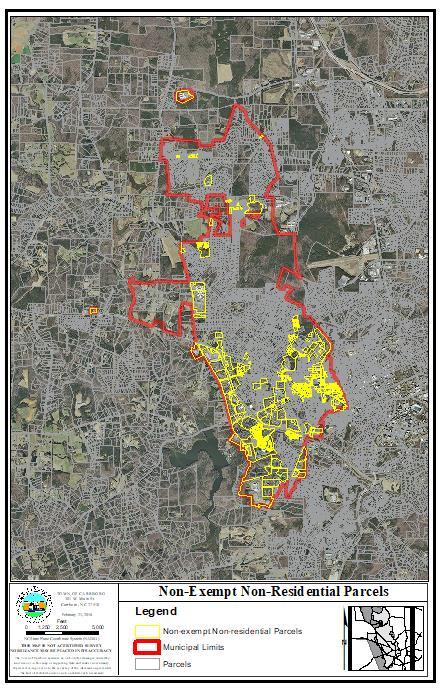
62 62