GEOLOGIC ATLAS OF BENTON
|
|
|
- Anthony Watson
- 5 years ago
- Views:
Transcription


1 Mapping Glacial Aquifers in Central MN as a Resource for Local Management Jeremy Rivord DNR Ecological and Water Resources October 1, 2012
2 GEOLOGIC ATLAS OF BENTON COUNTY, MINNESOTA COUNTY ATLAS SERIES C 23 PART A (Published separately by the Minnesota Geological Survey) PART B Plate 6. Hydrogeology of the Surficial Sand Aquifer Plate 7. Hydrogeologic Cross Sections Plate 8. Hydrogeology of the Buried Aquifers and the Rice Area Aquifer System Plate 9. Sensitivity of the Groundwater Systems to Pollution
3 1. Identify and Characterize Map Applications Primary aquifer sources and extents Zones of aquifer sensitivity Potential areas of groundwater discharge 2. Manage Water appropriation permit evaluation Water supply assistance 3. Protect Feedlot/nutrient management Environmental review support


 Minneapolis Meyer,")
4 Benton County hydrology is characterized by glacial materials till or sand/gravel During the last glaciation the county was most recently covered with materials from: Wadena lobe Superior lobe Grantsburg sublobe (outwash) Minneapolis Meyer, Meyer,
5 From Meyer, 2010
6 Part A Simplified surficial geology Sand and gravel Glacial till Bedrock outcrop From Meyer, 2010
7 Foley 2,600 people Sauk Rapids 12,800 people Rice 1,300 people
8 1. Identify and Characterize Map Applications Primary aquifer sources and extents Zones of aquifer sensitivity Potential areas of groundwater discharge 2. Manage Water appropriation permit evaluation Water supply assistance 3. Protect Feedlot/nutrient management Environmental review support
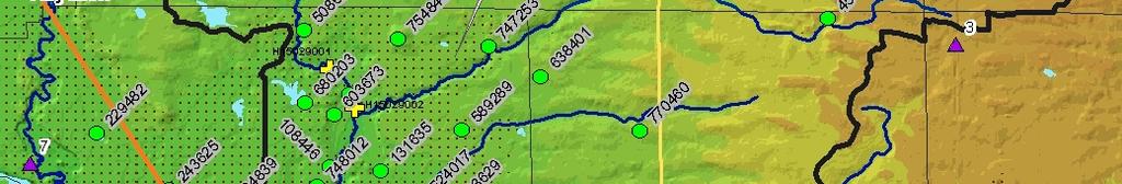
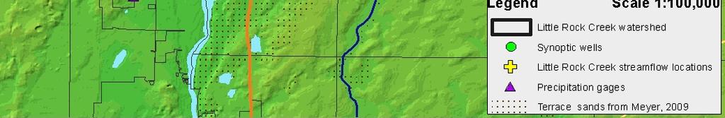
9 Characterize Hydrogeology of the Surficial Sand Aquifer Surficial sand aquifer extent, thickness and chemistry of sampled wells
10 Characterize Surficial sand aquifer extent, thickness and chemistry of sampled wells
11 Characterize Surficial sand aquifer extent, thickness and chemistry of sampled wells
12 Characterize Surficial sand aquifer extent, thickness and chemistry of sampled wells
13 Characterize Hydrogeologic Cross Sections Western portions of cross sections A A and B B Insert xsec AA BB from elk river to Miss Riv.
14 Characterize Hydrogeology of the Buried Aquifers Elevation of the potentiometric surface and reported water use for 2010 in the sub Emerald buried aquifer unit (sb)
15 Plate 8 Hydrogeology of the Buried Aquifers Legend for potentiometric surfaces
16 Characterize Hydrogeology of the Buried Aquifers Elevation of the potentiometric surface and reported water use for 2010 in the sub Emerald buried aquifer unit (sb)
17 Map Applications 1. Identify and Characterize Primary aquifer sources and extents Zones of aquifer sensitivity Potential areas of groundwater discharge 2. Manage Water appropriation permit evaluation Water supply assistance 3. Protect Feedlot/nutrient management Environmental review support
18 Manage Water Use Major Crop Irrigaiton Municipal Waterworks Commercial/Instituti onal Waterworks Non Crop Irrigation Livestock Watering Surficial Supra Emerald (se) Sub Emerald (sb) Pre Wisconsinan (sx) Pre Wisconsinan (sw) Unmapped
19 Manage Water Use Major Crop Irrigaiton Municipal Waterworks Commercial/Instituti onal Waterworks Non Crop Irrigation Livestock Watering Surficial Supra Emerald (se) Sub Emerald (sb) Pre Wisconsinan (sx) Pre Wisconsinan (sw) Unmapped


20 Manage Hydrogeology of the Buried Aquifers Rice Area Aquifer system


21 Manage Hydrogeology of the Buried Aquifers Rice Area Aquifer system


22 Plate 8 Hydrogeology of the Buried Aquifers Synoptic water level study April 2010 to July 2010 change in water levels July2010 to September 2010 change in water levels
23 Plate 8 Hydrogeology of the Buried Aquifers Synoptic water level study April 2010 to July 2010 change in water levels July2010 to September 2010 change in water levels
24 Characterize Hydrogeologic Cross Sections Western portions of cross sections AA and BB Insert xsec AA BB from elk river to Miss Riv.


25 Development Pro actively plan for future growth to protect water resources and minimize land use conflicts Provide information/education to appropriate audiences Map Applications 1. Locates available groundwater 2. Identifies heavily utilized aquifers
26 Map Applications 1. Identify and Characterize Primary aquifer sources and extents Zones of aquifer sensitivity Potential areas of groundwater discharge 2. Manage Water appropriation permit evaluation Water supply assistance 3. Protect Feedlot/nutrient management Environmental review support
27 Protect Sensitivity of the Groundwater Systems to Pollution Surface materials
28 Protect Sensitivity of the Groundwater Systems to Pollution Supra Emerald aquifer unit, se


29 Protect Sensitivity of the Groundwater Systems to Pollution Sub Emerald aquifer unit, sb
30 Map Applications Feedlot/nutrient management Reduce/minimize negative impacts of manure and fertilizer on surface water and groundwater 1. Feedlots in most sensitive areas are prioritized for BMPs, cost sharing and education 2. Concentrate communication on areas of concern


31 Protect Map Applications Encourage LGUs to adopt development related ordinances and policies with water based outcomes 1. Resource overlay districts maximum density standards for septic systems Stormwater management Landfill ordinances to be in least sensitive areas Municipal wellhead protection zones
32 Development Map Applications Provide information and education to appropriate audiences 1. Include a series in the county newsletter/newspaper 2. Library workshops incorporating the digital use 3. Provide GIS data on GeoMoose


33 Thank you! Participating well owners for chemistry sampling and synoptic cooperation Benton SWCD for field support and cooperation Numerous technical reviewers for the atlas