Towards a National Water Modeling System
|
|
|
- Laura Caldwell
- 5 years ago
- Views:
Transcription
1 Towards a National Water Modeling System


2


3
4 Towards a National Water Modeling System Don Cline Chief, Hydrology Laboratory National Weather Service Jerad Bales Chief Scientist for Water U.S. Geological Survey Bill Scharffenberg HEC-HMS Lead Developer Hydrologic Engineering Center Institute for Water Resources U.S. Army Corps of Engineers CUAHSI Witek Krajewski Chair, CUAHSI Board of Directors; Director, Iowa Flood Center; Rose and Joseph Summers Chair in Water Resources Engineering, University of Iowa
5 Outline Background: Integrated Water Resources Science and Services (IWRSS) and CUAHSI Three Grand Challenges What these demand of a National Water Modeling System Straw System High Level Components Straw Concept of Operations Path Forward


6 CUAHSI
7


8 WATER SECURITY HYPOXIA HYDROLOGIC EXTREMES
 predicting water flow and depth in all major and minor rivers to permit optimal operation of")

9 Grand Challenge #1 Ensure water security by: a) predicting surface and groundwater availability in all watersheds to enable water users to determine the least-cost source and plan for droughts, b) predicting water flow and depth in all major and minor rivers to permit optimal operation of multiple-use reservoirs, facilitate navigation and fully inform flood fighting efforts on levees, and c) tracking and predicting movement of hazardous contaminants accidently or deliberately released into the water supply to enable effective operation of control structures and issuance of notifications.


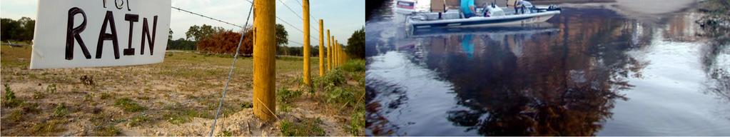
10 Grand Challenge #2 Understand and seamlessly predict the full range of hydrologic extremes, from floods to droughts and from short-term to long-term, and their relationships to large-scale climate, land and water management practices and other drivers.
 tracking nutrient and sediment movement throughout watersheds")

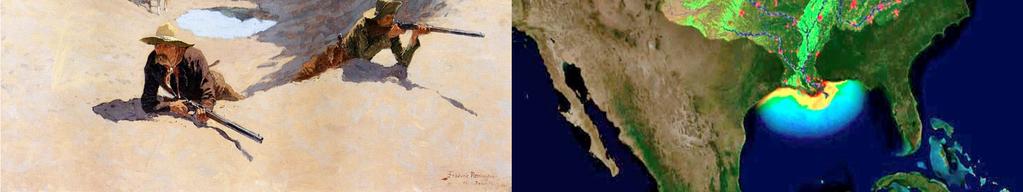
11 Grand Challenge #3 Reduce the occurrence of estuarine hypoxia everywhere along our coastline by: a) tracking nutrient and sediment movement throughout watersheds nationwide, and b) providing actionable predictive information that allows managers to effectively and efficiently control sources and enables more effective legislation
12 High-Level Requirements Emerging from Grand Challenges Watershed Modeling Everywhere, All the Time - Multiple time and space scales important - Fine-scale predictions needed for small watersheds - Hillslope and channel scale processes important - Long-term simulations required - Very short-term simulations required Surface and groundwater linkages necessary Transport and deposition processes necessary Vegetation and ecosystem response important Urban environments important Manipulation, control and consumption important
13 Additional Requirements Flexible Implementation and Use National Center will run national up to continental e.g. high-performance computing environment Regional Centers will run regionally down to individual watersheds e.g. small cluster to desktop computing environment Research might run any scale, any environment Earth System Approach Trans-disciplinary connectivity and interaction
14 Additional Requirements Family of Data Services Broad suite of geospatial data must be readily accessible to users of the system Topography and derivatives Surface and sub-surface characterization Hydrographic characterization Hydrometeorological forcings Observations
15 Additional Requirements Operational Subsystems Pre-processing engine Down-scaling, up-scaling, gap-filling Post-processing engine Product generation and distribution Traffic Control System management, dashboard Verification engine Regular (constant) skill/performance evaluation Challenging for watershed-scale modeling over large domains Archive subsystem Long-term storage and retrieval of data and key products
16 Additional Requirements Robust Development Environment and Improvement Process Code management system Software development tools Structured process for regular improvement

 Common")


17 Water Security Problem Specific Tools Problem Specific Tools Multi-scale modeling backbone Earth-System approach, standards National Water Modeling System (CORE) Common physical packages and simulation tools Mechanisms to link non-core tools Subsystems for pre- and postprocessing, verification, archive Integrated family of data services Hydrologic Extremes Hypoxia Problem Specific Tools Development framework/environment Conceptual System


18 Geospatial Data Services DEM, Topographic Derivatives, Hydrography Soils, Dynamic Vegetation, Land Use, and Crop Status Levees, Rating Curves, Reservoirs Geopolitical, Demographic Forcings Data Services High-resolution gridded surface weather and climate (analysis of record, forecasts) Observational Data Services NWIS Streamflow, Remote Sensing, Surface Weather, Groundwater, etc. Conceptual System
19 NOAA Mission:Scheduled forecasts and guidance to support decision-making Coverage: National Implementation: River Forecast Centers National Water Center Regional Servers NOAA Data Server USGSMission:Sub-daily simulation to support National Water Census and hydrologic research Coverage: National Implementation: State Water Science Centers National Water Center Regional Servers USACE Data Server CORE + Family of Data Services USGS Data Server Regional Servers USACEMission:Ad hoc simulation to support reservoir and navigation lock operational decisions Coverage:watersheds with reservoirs, rivers with navigation projects Implementation: Regional processing centers External Portal (Security) Straw Agency Usage

20 Path Forward Scoping Scoping Determine requirements and potential solution space Relatively unconstrained Team to begin 2012, 6-9 months Design Design Develop blueprints for system, project management framework Constrained by available resources Approximately 6-9 months Implementation Implementation Expectation of 3-5 years to complete baseline system


21 Towards a National Water Modeling System CUAHSI What are the intermediate development milestones? How much of what we have can be reused? Who manages the system? The codes? What is the improvement process? What is the role of academia? What is the role of the private sector?
22 Towards a National Water Modeling System Don Cline Chief, Hydrology Laboratory National Weather Service Jerad Bales Chief Scientist for Water U.S. Geological Survey Bill Scharffenberg HEC-HMS Lead Developer Hydrologic Engineering Center Institute for Water Resources U.S. Army Corps of Engineers CUAHSI Witek Krajewski Chair, CUAHSI Board of Directors Director, Iowa Flood Center Chair, Water Resources Engineering, University of Iowa
23 Scoping and Design Traceability Science Objective e.g. improve understanding and prediction of low flows as pertains to grand challenges Science Modeling Requirements e.g. necessary state variables and fluxes, resolutions, time and space scales, accuracy, precision Model Functional Requirements e.g. modeling approach (lumped, distributed, gridded, adaptive mesh, solver characteristics, data assimilation, etc. Data Functional Requirements e.g. meteorologic forcings, topography, land cover, vegetation phenology, soils, hydro-stratigraphy, etc. System Functional Requirements e.g. computational needs, subsystems, modularity, interoperability, storage, platform, development lifecycle

24 What makes it grand? Continued population growth with increased agricultural and industrial output and more demand for recreation. Demographic shifts with population moving to Florida, Arizona, Texas, and Southern California, which affects demands for large municipal water supplies. Changes in land use across forested, agricultural, and urban regions, which determines in part the location of water surplus deficit. Social changes in expectations for water purity, which controls what need a particular source of water can be used to meet. Changes in long term climate, which may affect where crops are grown and where municipal water is needed.


25 What makes it grand? Floods and droughts are among the Nation s most expensive natural hazards. Floods and droughts occur at a broad range of spatial scales. Onset of droughts is not readily apparent, so it often is unclear whether it is a dry spell or a true drought until the event is well along. Recovery of the natural system can be as long as the drought. The types of droughts (meteorological, hydrologic, and agricultural) have varying impacts and occur at different scales. Floods can be sudden with little time for preparation.
.")

26 What makes it grand? Nutrient reduction is EPA s primary approach to reduce hypoxia in the Gulf of Mexico, the Chesapeake Bay, and other bodies of water throughout the country. About 90% of the nitrate load to the Gulf comes from non-point sources (agricultural sources). Midwest Statesexperienced rapid land use changes between 2008 and 2011, with more than 75,000 acres per county converted to crop land. USDA economists calculate that the cost of removing nitrate alone from drinking water is more than $4.8 billion a year nationwide. Modeling water quality and nutrient transport is challenging due a number of serious constraints associated with the input data as well as existing knowledge gaps related to the mathematical description of landscape and in-stream biogeochemical processes. The Gulf of Mexico is the source of 72 percent of U.S. harvested shrimp, 66 percent of the harvested oysters, and 16 percent of the U.S. commercial fish harvest. Yet, there has been no measured economic effect of hypoxia on the Gulf of Mexico fisheries to date.