Lake Samish Comprehensive Stormwater Plan Capital Improvement Recommendations
|
|
|
- Jason Dean
- 5 years ago
- Views:
Transcription
1
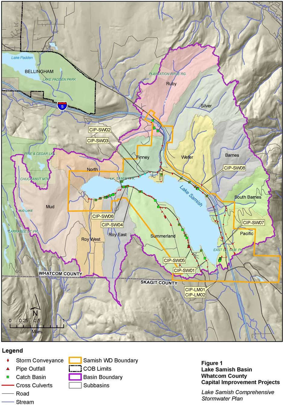
2 Lake Samish Comprehensive Stormwater Plan Capital Improvement Recommendations drainage. The easement could potentially be used to site a surface water quality treatment facility for the flow. The design objectives are to relocate roadway storm flows away from the parcel east of the culvert outlet to eliminate periodic flooding of the parcel, and to provide basic treatment for the drainage area. Permitting, regulatory, and other issues affecting this project include; proximity to the lake shoreline, space constraints, traffic control concerns and Whatcom County limitations on seasonal clearing. Potential Alternatives: Potential alternatives to address this problem include: - regrading of the ditchline and relocation of the cross-culvert to discharge along an existing County easement located approximately 300 LF north of the site, - obtain utility easement from property owner at 326 Shallow Shore Drive and install a treatment bioswale at the existing discharge locations, - no structural improvements. Preferred Solution: The preferred solution for this issue is to regrade the ditchline along the west side of Shallow Shore Drive to drain to a point approximately 300 LF north of existing culvert. A new cross-culvert can then be installed to direct the flow to the lake via an existing Whatcom County easement. The project would include construction of a treatment bioswale or raingarden within the County easement to provide basic treatment for the stormwater flows. Redirection of this drainage will eliminate the current flooding impacts to the parcel located at 326 Shallow Shore Drive, and construction of the bioswale will allow for basic treatment of stormwater which previously was being discharged directly to the lake untreated. CIP-SW01 is a highest priority project, and implementation is recommended within the current six year planning A concept-level cost estimate of $160,000 has been prepared for this capital project assuming a 30% contingency on construction costs and a 50% contingency on soft costs and engineering/design. CIP-SW02 Replace Cross-Culvert on North Lake Samish Drive; ~1,000 LF West of Greene Point Lane (Priority Highest) Project Description: Under storm conditions, the existing cross culvert (located approximately 1,000 LF west of Greene Point Lane) is currently undersized to provide adequate drainage for the roadway drainage flows and the flow from an existing unnamed creek draining out of the North sub-basin. The design objectives for this project include; protecting public health and safety by providing an adequately sized conveyance system to safely convey storm flows under the roadway at this location, protecting slope stability along the north side of the roadway, and preserving the aesthetic integrity of the area. Permitting, regulatory, and other issues affecting this project include; proximity to the lake shoreline, space constraints, and Whatcom County limitations on seasonal clearing. 2
3 Lake Samish Comprehensive Stormwater Plan Capital Improvement Recommendations Potential Alternatives: Potential alternatives are to replace the existing, undersized culvert with a larger culvert or to implement no structural improvements. Preferred Solution: The preferred alternative to address this issue is the removal/replacement of the existing, undersized culvert with a cross-culvert sized to convey storm flows safely under the roadway with no flooding. The primary benefit of this project will be the protection of public health and safety by eliminating roadway flooding during storm events. CIP-SW02 is a highest priority project, and implementation is recommended within the current six year planning A concept-level cost estimate of $50,000 has been prepared for this capital project assuming a 30% contingency on construction costs and a 50% contingency on soft costs and engineering/design. CIP-SW03 - Replace Cross-Culvert on North Lake Samish Drive; ~1,400 LF West of Greene Point Lane (Priority Highest) Project Description: Under storm conditions, the existing cross culvert (located approximately 1,400 LF west of Greene Point Lane) is currently undersized to provide adequate drainage for the roadway drainage flows and the flow from an existing unnamed creek draining out of the North sub-basin. The design objectives for this project include; protect public health and safety by providing an adequately sized conveyance system to safely convey storm flows under the roadway at this location, protecting slope stability along the north side of the roadway, and preserving the aesthetic integrity of the area. Permitting, regulatory, and other issues affecting this project include; proximity to the lake shoreline, space constraints, traffic control concerns, and Whatcom County limitations on seasonal clearing. Potential Alternatives: Potential alternatives are to replace the existing, undersized culvert with a larger culvert or to implement no structural improvements. Preferred Solution: The preferred alternative to address this issue is the removal/replacement of the existing, undersized culvert with a cross-culvert sized to convey storm flows safely under the roadway with no flooding. The primary benefit of this project will be the protection of public health and safety by eliminating roadway flooding during storm events CIP-SW03 is a highest priority project, and implementation is recommended within the current six year planning A concept-level cost estimate of $50,000 has been prepared for this capital project assuming a 30% contingency on construction costs and a 50% contingency on soft costs and engineering/design. 3
4 Lake Samish Comprehensive Stormwater Plan Capital Improvement Recommendations CIP-SW04 - Ditch Regrading and Culvert Installation on West Lake Samish Drive; ~2,600 LF East of the Bridge (Priority Highest) Project Description: Under storm conditions, the existing cross culvert (located approximately 2,600 LF east of the bridge) is currently undersized to provide adequate drainage for the roadway drainage flows and the overland flows originating from the slope south of the roadway (Roy East Sub-basin). Additionally, the capacity of the south-side road ditch drainage is insufficient to adequately convey runoff to the culvert inlet. The design objectives for this project include; protect public health and safety by providing road ditch grading and an adequately sized conveyance system to safely convey storm flows under the roadway at this location, protecting slope stability along the south side of the roadway, and preserving the aesthetic integrity of the area. Permitting, regulatory, and other issues affecting this project include; proximity to the lake shoreline, space constraints, and Whatcom County limitations on seasonal clearing. Potential Alternatives: Potential alternatives are to regrade the south-side road ditch and to replace the existing, undersized culvert with a larger culvert, or to implement no structural improvements. Preferred Solution: The preferred alternative to address this issue is to regrade the drainage of the adjacent south-side road ditch and to remove/replace the existing, undersized culvert with a cross-culvert sized to convey storm flows safely under the roadway with no flooding. The primary benefit of this project will be the protection of public health and safety by eliminating roadway flooding during storm events CIP-SW04 is a highest priority project, and implementation is recommended within the current six year planning period. A concept-level cost estimate of $85,000 has been prepared for this capital project assuming a 30% contingency on construction costs and a 50% contingency on soft costs and engineering/design. CIP-SW05 - Roadway Drainage Reconfiguration Adjacent to Calmor Cove Club Mobile Home Park at 316 West Lake Samish Drive (Priority High) Project Description: An existing County cross-culvert currently discharges to the east side of West Lake Samish Road, directly upstream of a private 12-inch diameter stormdrain located on the property occupied by Calmor Cove Mobile Home Park. The 12-inch stormdrain is approximately 300LF in length and runs under the existing mobile homes to an open channel within the park. The existing private stormdrain is tremendously difficult to service and has backed up in the past, flooding portions of the park. The design objectives for this project include; relocation of the discharge point for the stormwater flows currently being released above the mobile home park to a location farther north along West Lake Samish Drive, development of a water treatment strategy for the new discharge facility, and protection of the existing aesthetic quality of the area. 4
5 Lake Samish Comprehensive Stormwater Plan Capital Improvement Recommendations Permitting, regulatory, and other issues affecting this project include; proximity to the lake shoreline, potential easement requirements, space constraints, traffic control and Whatcom County limitations on seasonal clearing. Potential Alternatives: Potential alternatives include: - Regrading the west-side road ditch and relocating the cross culvert to a point north along West Lake Samish Drive, - Installation of a manhole structure at the current culvert discharge connecting it directly to the private stormdrain under the mobile home park. Preferred Solution: The preferred solution for this issue is to regrade the west-side road ditch and relocate the cross culvert to a point north along West Lake Samish Drive. A new storm drain alignment will need to be identified to carry flows from the new culvert discharge to the lake shore. The project should evaluate the feasibility for water treatment at the discharge site, and a new utility easement may be required for the project. Potential benefits from the project include the elimination of the flooding potential within the park and implementation of water quality treatment to the stormwater flow. CIP-SW05 is a high rated priority project, and implementation is recommended within the current six year planning window or the next six year planning window. Prior to implementation, management staff should re-evaluate the project s execution strategy, value, and potential stormwater benefits. A concept-level cost estimate of $232,000 has been prepared for this capital project assuming a 30% contingency on construction costs and a 50% contingency on soft costs and engineering/design. CIP-SW06 - Water Quality Treatment Options for Catch Basins on West Lake Samish Drive; ~1,000 LF East of the Bridge (Priority High) Project Description: On the south side of West Lake Samish Drive, approximately 1,000 LF east of the bridge, four storm drain catch basins are located within an expanse of gravel paving. The gravel area is used for parking and as driveway entrances to the homes located south of West Lake Samish Drive at that location. The finish grade rim elevations for these catch basins are slightly below the gravel grade, and sediment regularly washes into the basins during storm events. The design objectives for this project include implementation of a water quality treatment strategy to treat the runoff from the surround impervious gravel area while maintaining the existing hydraulic profile and providing adequate conveyance for storm flows. Permitting, regulatory, and other issues affecting this project include; proximity to the lake shoreline, space constraints, traffic control issues, and the Whatcom County limitations on seasonal clearing. Potential Alternatives: Potential alternatives to address this issue include installation of individual catch basin filter inserts, redirection of all catch basin flow to a centralized canister vault treatment system, or implementation of no structural improvements. Preferred Solution: 5
6 Lake Samish Comprehensive Stormwater Plan Capital Improvement Recommendations The preferred alternative is the installation of individual catch basin filter inserts at each catch basin. The expected benefit of this solution include a reduction in the amount of stormwater pollutants discharging to the lake. CIP-SW06 is a high rated priority project, and implementation is recommended within the current six year planning window or the next six year planning window. Prior to implementation, management staff should re-evaluate the project s execution strategy, value, and potential stormwater benefits. A concept-level cost estimate of $17,000 has been prepared for this capital project assuming a 30% contingency on construction costs and a 50% contingency on soft costs and engineering/design. CIP-SW07 - Energy Dissipation at Pacific Creek Crossing on East Lake Samish Drive (Priority High) Project Description: The existing WSDOT culvert which conveys Pacific Creek from the east side to the west side of the freeway has a hanging pipe discharge which discharges flow into a plunge pool just east of East Lake Samish Drive. The banks surrounding the plunge pool show significant signs of the scour erosion which occurs during heavy storm events. Flow from the plunge pool is directed to the inlet end of an existing County cross-culvert which conveys the creek under East Lake Samish Drive. The design objectives for this project include; energy dissipation and flow redirection to reduce scour erosion adjacent to the roadway, elimination of the hanging culvert discharge and plunge pool at the discharge outlet of the WSDOT culvert, and revegetation/restoration of the impacted site. Permitting, regulatory, and other issues affecting this project include; proximity to the lake shoreline, WSDOT permitting, space constraints, traffic control concerns, and the Whatcom County limitations on seasonal clearing. Potential Alternatives: Potential alternatives to address this issue include: - Construction of an armored channel with weir walls for energy dissipation, - Installation of a manhole structure to connect the discharge end of the WSDOT culvert to the inlet end of the cross culvert under East Lake Samish Drive. - Implementation of no structural improvements. Preferred Solution: The preferred solution for this issue is the construction of an armored channel equipped with wier structures for energy dissipation. The project should include revegetation/restoration of the existing scoured area adjacent to East Lake Samish Drive. The anticipated benefits from this solution include; reduction of sediment discharge to the lake, stabilization of the eroded area adjacent to the roadway, and elimination of a potential flooding hazard during large storm events. CIP-SW07 is a high rated priority project, and implementation is recommended within the current six year planning window or the next six year planning window. Prior to implementation, management staff should re-evaluate the project s execution strategy, value, and potential stormwater benefits. A concept-level cost estimate of $87,000 has been prepared for this capital project assuming a 30% contingency on construction costs and a 50% contingency on soft costs and engineering/design. 6
7 Lake Samish Comprehensive Stormwater Plan Capital Improvement Recommendations CIP-SW08 - Energy Dissipation Solutions and Erosion Controls for Creek Crossing on Manley Road; West of Wefer Creek, East of Barnes Creek (Priority Low) Project Description: An existing 36-inch culvert under Manley Road, (~ LF in length), conveys flow from an unnamed creek in the Wefer Sub-basin, (creek located west of Wefer Creek and east of Barnes Creek). The culvert is installed at a 30-40% slope and has a hanging discharge, (10-15 ft above grade), which discharges water to the creek bed below. During storm events, flow velocities in the pipe are high enough to project a discharge stream ft from the end of the culvert before the flow hits the creek bed. The design objectives for this project include; energy dissipation and flow redirection to reduce scour erosion at the culvert discharge, elimination of the hanging culvert discharge and plunge pool at the discharge outlet, and revegetation/restoration of the eroded stream bank. Permitting, regulatory, and other issues affecting this project include; work with the creek bed, site access, and the Whatcom County limitations on seasonal clearing. Potential Alternatives: Potential alternatives to address this issue include: - Down-angle and extend culvert down to the creek bed elevation before discharge, - Implementation of no structural improvements. Preferred Solution: The preferred solution for this issue is to extend the existing culvert at a down-angle to a point of direct discharge into the creek. Project implementation will require an armored splash pad at the discharge point and restoration of the downstream watercourse utilizing natural drainage alternatives such as amended soils, constructed step-pools, and revegetation with native plants. CIP-SW08 is a low rated priority project, and implementation is recommended within the current six year planning window or the next six year planning window. Prior to implementation, management staff should re-evaluate the project s execution strategy, value, and potential stormwater benefits. A concept-level cost estimate has not been prepared for this capital project because it scheduled for implementation outside the current planning window and additional study is required to determine feasible strategies for implementation. Lake-Level Management CIP CIP-LM01 - Friday Creek Dredging (Priority Highest) Project Description: Since its installation in the 1990s, the Friday Creek retention dam has experienced a build up of stream-deposited sediment both on the upstream and downstream sides of the dam. Questions and concerns have arisen regarding the impact this sedimentation is having on the normal operation of the retention structure. Programmatic recommendations included in this planning effort call for the preparation of a dredging feasibility study to provide recommendations with regard to the following; a) Required limits of dredging, 7
8 Lake Samish Comprehensive Stormwater Plan Capital Improvement Recommendations b) Dredging schedule (periodic), c) Permitting strategy d) Dredging means and methods, e) Cost comparison between periodic dredging and annual removal of the entire dam structure f) Funding options. Based upon the results of this feasibility study, a dredging program may be recommended for the creek. The design objectives for this project include; removal of sediment build-up adjacent to the retention structure while minimizing the adverse impacts to the aquatic ecosystem. Permitting, regulatory, and other issues affecting this project include; work within the creek bed, maintenance of the retention dam function, and Whatcom County limitations on seasonal clearing. Potential Alternatives: Potential alternative solutions for this issue are channel dredging, seasonal removal of the complete retention dam structure, and leaving the channel sedimentation as it is. Preferred Solution: The preferred alternative for this project is to dredge and restore the Friday Creek channel immediately upstream and downstream of the retention dam. Benefits expected from implementation of this alternative include; increased water retention behind the dam structure, easier maintenance and operation, and enhanced habitat for aquatic life. Prior to implementation, a dredging feasibility study should be performed to determine the practicality of dredging and to assess the value potential lake management benefits of the project. CIP-LM01 is a highest priority project, and implementation is recommended within the current six year planning window. A concept-level cost estimate of $97,000 has been prepared for this capital project assuming a 30% contingency on construction costs and a 50% contingency on soft costs and engineering/design. CIP-LM02 - Friday Creek Flowmeter (Priority Low) Project Description: Currently, the only method for estimating flow in the creek is related to the height of the water flow over the weir. This flow metering method has inherent inaccuracies and is hard to verify. For that reason, a proposal has been made to install a calibrated flow meter structure with the creek channel to measure flows. With the irregular nature of the existing creek channel, the amount of in-stream debris in the creek, and the historic beaver activity in the area; metering of the creek may be impractical. Programmatic recommendations included in this planning effort call for the preparation of a feasibility study to address and/or provide recommendations regarding the following; a) Applicable metering methods, b) Channel considerations, c) Expected environmental effects and permitting strategy, d) Options for addressing beaver activity, e) Project costs and funding options 8
9 Lake Samish Comprehensive Stormwater Plan Capital Improvement Recommendations Based upon the results of this feasibility study, flow metering options may be recommended for the creek. The design objective for this project is to implement an accurate, in-stream flow metering strategy for Friday Creek. Permitting, regulatory, and other issues affecting this project include; permitting for work within the stream channel, irregularities in the channel cross-section, space constraints, and Whatcom County limitations on seasonal clearing. Potential Alternatives: Potential alternative solutions for this issue are; modification of the existing retention dam to provide reliable flow data, installation of an in-stream flowmeter structure, or to construct no flow metering device. Preferred Solution: The preferred solution to this issue is the modification of the existing retention dam to provide reliable flow data year round. Accurate field flow data for the creek will help guide operation of the dam structure to provide the maximum in-stream flows possible during the summer months. In turn, this will benefit downstream aquatic habitat and provide more reliable flows to the Samish River basin. CIP-LM02 is a low rated priority project, and implementation is recommended within the current six year planning window or the next six year planning window. Prior to implementation, a metering feasibility study should be performed to examine the practicality of metering the creek and to determine the value and potential lake management benefits of the project. A concept-level cost estimate has not been prepared for this capital project because it scheduled for implementation outside the current planning window and additional study is required to determine feasible strategies for implementation. 9
10 Lake Samish Comprehensive Stormwater Plan Capital Improvement Recommendations Table No. 1 - Summary of Recommended Capital Improvement Projects Capital Project Description Stormwater Management CIP Relocate Culvert at 326 Shallow Shore CIP-SW01 Drive Replace Cross-Culvert on North Lake CIP-SW02 Samish Drive (~1,000 LF West of Greene Point Lane Replace Cross-Culvert on North Lake CIP-SW03 Samish Drive (~1,400 LF West of Greene Point Lane Ditch Regrading and Culvert CIP-SW04 Installation on West Lake Samish Drive (~2,600 LF East of the Bridge) Roadway Drainage Reconfiguration Adjacent to Calmor Cove Club Mobile CIP-SW05 Home Park (316 West Lake Samish Drive) WQ Treatment Options for Catch CIP-SW06 Basins on W. Lk. Samish Dr. (~1,000LF E. of the Bridge) Energy Dissipation at Pacific Creek CIP-SW07 Crossing on East Lake Samish Drive Energy Dissipation Solutions and Erosion Controls for Creek Crossing on CIP-SW08 Manley Road (West of Wefer Creek, East of Barnes Creek) Lake-level Management CIP CIP-LM01 CIP-LM02 Capital Project Priority Sub-basin Problems Addressed (or partially addressed) Recommend Inclusion on County CIP? Recommended Schedule for Implementation Concept- Level Cost Highest Summerland Flooding of private Yes Within 6-yrs $160,000 property Highest Silver Roadway flooding Yes Within 6-yrs $50,000 Highest Silver Roadway flooding Yes Within 6-yrs $50,000 Highest Summerland Roadway flooding Yes Within 6-yrs $85,000 High Summerland Potential flooding of private property High Roy East Water quality issues at CBs High Pacific Excessive scour & plunge pool adjcact to roadway Low Wefer Excessive flow velocities and erosion at culvert discharge Yes Yes Within 6-yrs & beyond Within 6-yrs & beyond $232,000 $17,000 No >6-yrs $87,000 No >6-yrs No Estimate Friday Creek Dredging Highest Basin Ck. Sedimentation Yes Within 6-yrs $97,000 Friday Creek Flowmeter Low Basin Unreliable flow data No >6-yrs No Estimate 10


11 Lake Samish Comprehensive Stormwater Plan Capital Improvement Recommendations 11
12 Lake Samish Comprehensive Stormwater Plan Capital Improvement Recommendations Limitations and Summary Limitations The structural issues and subsequent recommendations detailed in this technical memorandum were identified from the following sources: discussions at three separate public meetings, discussions with Whatcom County staff and stakeholders, research of publicly available documents and information available from the County, from stakeholders and on the internet, and field visits to the Lake Samish Basin. Summary This memorandum outlines the recommended structural stormwater and lake-level management solutions (capital improvement projects, CIP) developed as a part of this planning effort. The capital improvement projects presented have been organized into two separate management categories; stormwater and lake-level control. Implementation of the stormwater management CIP should occur as part of the overall comprehensive stormwater management program. The lake-level CIP should be implemented as part of the ongoing management of the Friday Creek detention structure as administered by the Lake Management Dist. No. 1. A summary of the recommended capital projects is included below. Stormwater Management CIP CIP-SW01 Relocate Culvert at 326 Shallow Shore Drive CIP-SW02 Replace Cross-Culvert on North Lake Samish Drive (~1,000 LF West of Greene Point Lane CIP-SW03 - Replace Cross-Culvert on North Lake Samish Drive (~1,400 LF West of Greene Point Lane CIP-SW04 - Ditch Regrading and Culvert Installation on West Lake Samish Drive (~2,600 LF East of the Bridge) CIP-SW05 - Roadway Drainage Reconfiguration Adjacent to Calmor Cove Club Mobile Home Park (316 West Lake Samish Drive) CIP-SW06 - Water Quality Treatment Options for Catch Basins on West Lake Samish Drive (~1,000 LF East of the Bridge) CIP-SW07 - Energy Dissipation at Pacific Creek Crossing on East Lake Samish Drive CIP-SW08 - Energy Dissipation Solutions and Erosion Controls for Creek Crossing on Manley Road (West of Wefer Creek, East of Barnes Creek) Lake-Level Management CIP CIP-LM01 - Friday Creek Dredging CIP-LM02 - Friday Creek Flowmeter 12


13 CIP-SW01: Relocate Culvert 326 Shallow Shore Dr. HIGHEST PRIORITY Project Description CIP-SW01 The existing cross culvert located at 326 Shallow Shore Drive discharges onto the western edge of the parcel bordering the lake at that location. During heavy storm events, discharge from this culvert overwhelms an existing private culvert leading to the lake and floods the eastern portion of the property. The County currently possesses an easement access to the lake approximately 300 LF north along Shallow Shore Drive which could be used as an alternate for this stormwater drainage. The easement could potentially be used to site a surface water quality treatment facility for the flow. Preferred Project Solution: The preferred solution for this issue is to regrade the ditchline along the west side of Shallow Shore Drive to drain to a point approximately 300 LF north of existing culvert, install a new cross-culvert directing the flow to the lake via a treatment bioswale within the County easement. Expected Benefits: Eliminate existing flooding issues on the private property. Provide water quality treatment of stormwater flow at the new discharge location. Design Objectives and Requirements: Relocate the culvert stormwater discharge to an existing County lake-access easement located approximately 300LF north along Shallow Shore Drive. Regrade ditchline along the west edge to Shallow Shore Drive to drain to the new discharge point. Provide water quality treatment capacity at the new discharge point in the form of a bioswale or raingarden Permitting, Regulatory, or Other Issues: Permitting, regulatory, and other issues affecting this project include; proximity to the lake shoreline, space constraints, traffic control concerns, and Whatcom County limitations on seasonal clearing. Estimated Costs (2011 dollars) $160,000 Implementation Schedule: Within the 6-year planning window.
 is currently undersized to provide adequate drainage for flows from the roadway drainage and an existing unnamed creek draining out of the North sub-basin.")
14 CIP-SW02 CIP-SW02: Replace Culvert North Lake Samish Drive (01) Project Description HIGHEST PRIORITY Under storm conditions, the existing cross culvert (located approximately 1,000 LF west of Greene Point Lane) is currently undersized to provide adequate drainage for flows from the roadway drainage and an existing unnamed creek draining out of the North sub-basin. Preferred Project Solution: The preferred alternative to address this issue is the removal/replacement of the existing, undersized culvert with a new cross-culvert sized to convey storm flows safely under the roadway with no flooding. Expected Benefits: Eliminating roadway flooding during storm events, Maintenance of slope stability on the north side of the roadway, Protection of public health and safety. Design Objectives and Requirements: Provide an adequately sized stormwater conveyance system to safely convey storm flows under the roadway at this location, Maintenance of existing aesthetic condition of the area, Permitting, Regulatory, or Other Issues: Permitting, regulatory, and other issues affecting this project include; proximity to the lake shoreline, space constraints, traffic concerns and Whatcom County limitations on seasonal clearing. Estimated Costs (2011 Dollars) $50,000 Implementation Schedule: Within the 6-year planning window.
 is currently undersized to provide adequate drainage for flows from the roadway drainage and the existing unnamed creek draining out of the North sub-basin.")
15 CIP-SW03 CIP-SW03: Replace Culvert North Lake Samish Drive (02) HIGHEST PRIORITY Project Description Under storm conditions, the existing cross culvert (located approximately 1,000 LF west of Greene Point Lane) is currently undersized to provide adequate drainage for flows from the roadway drainage and the existing unnamed creek draining out of the North sub-basin. Preferred Project Solution: The preferred alternative to address this issue is the removal/replacement of the existing, undersized culvert with a cross-culvert sized to convey storm flows safely under the roadway with no flooding. Expected Benefits: Elimination of roadway flooding, Protection of public health and safety. Design Objectives and Requirements: Provide an adequately sized stormwater conveyance system to safely convey storm flows under the roadway at this location. Maintenance of slope stability on the north side of the roadway. Permitting, Regulatory, or Other Issues: Permitting, regulatory, and other issues affecting this project include; proximity to the lake shoreline, space constraints, traffic control concerns, and Whatcom County limitations on seasonal clearing. Estimated Costs (2011 Dollars) $50,000 Implementation Schedule: Within the 6-year planning window.
 is currently undersized to provide adequate")
16 CIP-SW04: Ditchline Rehab & Culvert Installation W Lk Samish Dr. HIGHEST PRIORITY CIP-SW04 Project Description Under storm conditions, the existing cross culvert (located approximately 2,600 LF east of the bridge) is currently undersized to provide adequate drainage for the roadway drainage flows and the overland flows originating from the slope south of the roadway (Roy East Sub-basin). Additionally, the capacity of the south-side road ditch drainage is insufficient to adequately convey runoff to the culvert inlet. Preferred Project Solution: The preferred alternative to address this issue is to regrade the drainage of the adjacent south-side road ditch and to remove/replace the existing, undersized culvert with a crossculvert sized to convey storm flows safely under the roadway with no flooding. Expected Benefits: Elimination of roadway flooding during heavy storm events, Protection of public health and safety. Design Objectives and Requirements: Provide an adequately sized conveyance system to convey storm flows under the roadway at this location, Protecting slope stability along the north side of the roadway, Preserve the aesthetic integrity of the area. Permitting, Regulatory, or Other Issues: Permitting, regulatory, and other issues affecting this project include; proximity to the lake shoreline, space constraints, traffic control concerns, and Whatcom County limitations on seasonal clearing Estimated Costs (2011 Dollars) $85,000 Implementation Schedule: Within the 6-year planning window.


17 CIP-SW05: Reconfigure Road Drainage Calmor Cove W Lk Samish Dr HIGH PRIORITY CIP-SW05 Project Description An existing County cross-culvert currently discharges to the east side of West Lake Samish Road, directly upstream of a private 12- inch diameter stormdrain located on the property occupied by Calmor Cove Mobile Home Park. The 12-inch stormdrain is approximately 300LF in length and runs under the existing mobile homes to an open channel within the park. The existing private stormdrain is tremendously difficult to service and has backed up in the past, flooding portions of the park. Preferred Project Solution: The preferred solution for this issue is to regrade the west-side road ditch and relocate the cross culvert to a point ~750LF north along West Lake Samish Drive. A new storm drain alignment will need to be identified to carry flows from the new culvert discharge to the lake shore. Expected Benefits: Elimination of the flooding potential within the park, Potential implementation of water quality treatment to the stormwater flow. Design Objectives and Requirements: Relocation of stormwater flows currently being released above the mobile home park to a location farther north along West Lake Samish Drive, Development of a water treatment strategy for the new discharge facility, Protection of the existing aesthetic quality of the area. Permitting, Regulatory, or Other Issues: Permitting, regulatory, and other issues affecting this project include; proximity to the lake shoreline, potential easement requirements, space constraints, traffic control and Whatcom County limitations on seasonal clearing Estimated Costs (2011 Dollars) $232,000 Implementation Schedule: Within the 6-year planning window.
18 CIP-SW06: Water Quality Treatment Options for Catch Basins in W. Lk. Samish Dr. HIGH PRIORITY CIP-SW06 Project Description On the south side of West Lake Samish Drive, approximately 1,000 LF east of the bridge, four storm drain catch basins are located within an expanse of gravel paving. The gravel area is used for parking and as driveway entrances to the homes located south of West Lake Samish Drive at that location. The finish grade rim elevations for these catch basins are slightly below the gravel grade, and sediment regularly washes into the basins during storm events. Preferred Project Solution: The preferred alternative is the installation of individual catch basin filter inserts at each catch basin. Expected Benefits: Reduction in the amount of stormwater pollutants discharging to the lake, Elimination of the need to replace or reconfigure catch basins. Design Objectives and Requirements: Implementation of a water quality treatment strategy to treat the runoff from the surround impervious gravel area, Maintenance of the existing hydraulic profile, Provide adequate conveyance for storm flows. Permitting, Regulatory, or Other Issues: Permitting, regulatory, and other issues affecting this project include; proximity to the lake shoreline, space constraints, and traffic control issues. Estimated Costs (2011 Dollars) $17,000 Implementation Schedule: Within the current or next 6-year planning window.


19 CIP-SW07: Energy Dissipation Pacific Ck East Lk. Samish Dr. HIGH PRIORITY CIP-SW07 Project Description The existing WSDOT culvert which conveys Pacific Creek from the east side to the west side of the freeway has a hanging pipe discharge which discharges flow into a plunge pool just east of East Lake Samish Drive. The banks surrounding the plunge pool show significant signs of the scour erosion which occurs during heavy storm events. Flow from the plunge pool is directed to the inlet end of an existing County cross-culvert which conveys the creek under East Lake Samish Drive. Preferred Project Solution: The preferred solution for this issue is the construction of an armored channel equipped with weir structures for energy dissipation. The project should include revegetation/restoration of the existing scoured area adjacent to East Lake Samish Drive. Expected Benefits: Reduction of sediment discharge to the lake, Stabilization of the eroded area adjacent to the roadway, Elimination of a potential flooding hazard during large storm events Design Objectives and Requirements: Energy dissipation and flow redirection to reduce scour erosion adjacent to the roadway, Elimination of the hanging culvert discharge and plunge pool at the discharge outlet of the WSDOT culvert, Revegetation/restoration of the impacted site. Permitting, Regulatory, or Other Issues: Permitting, regulatory, and other issues affecting this project include; proximity to the lake shoreline, WSDOT permitting, space constraints, traffic control concerns, and the Whatcom County limitations on seasonal clearing Estimated Costs (2011 Dollars) $87,000 Implementation Schedule: Within the current or next 6-year planning window.
.")
20 CIP-SW08: Energy Dissipation on Culvert Unnamed Ck Manley Road LOW PRIORITY CIP-SW08 Project Description An existing 36-inch culvert under Manley Road, (~ LF in length), conveys flow from an unnamed creek in the Wefer Subbasin, (creek located west of Wefer Creek and east of Barnes Creek). The culvert is installed at a 30-40% slope and has a hanging discharge, (10-15 ft above grade), which discharges water to the creek bed below. During storm events, flow velocities in the pipe are high enough to project a discharge stream ft from the end of the culvert before the flow hits the creek bed. Preferred Project Solution: The preferred solution for this issue is to extend the existing culvert at a down-angle to a point of direct discharge into the creek. Project implementation will require an armored splash pad at the discharge point and restoration of the downstream watercourse utilizing natural drainage alternatives such as amended soils, constructed step-pools, and revegetation with native plants. Expected Benefits: Creek velocity reductions, Reduction is stream channel erosion. Improvement of aquatic habitat. Design Objectives and Requirements: Energy dissipation and flow redirection to reduce scour erosion at the culvert discharge, Elimination of the hanging culvert discharge and plunge pool at the discharge outlet, Revegetation/restoration of the eroded stream bank. Permitting, Regulatory, or Other Issues: Permitting, regulatory, and other issues affecting this project include; work with the creek bed, site access, and the Whatcom County limitations on seasonal clearing. Estimated Costs No cost estimate prepared Implementation Schedule: Beyond the 6-year planning window.


21 CIP-LM01: Friday Ck. Dredging Project Description HIGHEST PRIORITY CIP-LM01 Since its installation in the 1990s, the Friday Creek retention dam has experienced a build up of stream-deposited sediment both on the upstream and downstream sides of the dam. Questions and concerns have arisen regarding the impact this sedimentation is having on the normal operation of the retention structure. Programmatic recommendations included in this planning effort call for the preparation of a dredging feasibility study to provide recommendations with regard to the following; a. Required limits of dredging, b. Dredging schedule (periodic), c. Permitting strategy d. Dredging means and methods, e. Cost comparison between periodic dredging and annual removal of the entire dam structure f. Funding options. Based upon the results of this feasibility study, a dredging program may be recommended for the creek. Preferred Project Solution: The preferred alternative for this project is to dredge and restore the Friday Creek channel immediately upstream and downstream of the retention dam. Expected Benefits: increased water retention behind the dam structure, easier maintenance & operation of dam structure, enhanced aquatic habitat. Design Objectives and Requirements: Development of method to remove sediment build-up around the dam structure, Protection of existing aquatic habitat, Maintenance of lake-level control functions during implementation. Permitting, Regulatory, or Other Issues: Permitting, regulatory, and other issues affecting this project include; proximity to the lake shoreline, space constraints, and Whatcom County limitations on seasonal clearing. Estimated Costs (2011 dollars) $97,000 Implementation Schedule: Within the current or next 6-year planning windows.


22 CIP-LM02: Friday Ck. Flowmeter Project Description LOW PRIORITY CIP-LM02 Currently, the only method for estimating flow in Friday Creek is relate the height of the water flow over the dam weir to the total flow in the creek. This flow metering method has inherent inaccuracies and is hard to verify. For that reason, a proposal has been made to install a calibrated flow meter structure within the creek channel to measure flows. With the irregular nature of the existing creek channel, the amount of in-stream debris in the creek, and the historic beaver activity in the area; metering of the creek may be impractical. Programmatic recommendations included in this planning effort call for the preparation of a feasibility study to address and/or provide recommendations regarding the following; a) Applicable metering methods, b) Channel considerations, c) Expected environmental effects and permitting strategy, d) Options for addressing beaver activity, e) Project costs and funding options Based upon the results of this feasibility study, a flow metering options may be recommended for the creek. Preferred Project Solution: The preferred solution to this issue is the modification of the existing retention dam to provide reliable flow data year round. Expected Benefits: improved operation of the dam structure to provide the maximum in-stream flows possible during the summer months, improvements of aquatic habitat. Design Objectives and Requirements: develop an accurate in-stream flow metering strategy for Friday Creek. Permitting, Regulatory, or Other Issues: Permitting, regulatory, and other issues affecting this project include; permitting for work within the stream channel, irregularities in the channel cross-section, space constraints, and Whatcom County limitations on seasonal clearing. Estimated Costs A concept-level cost estimate has not been prepared for this capital project. Implementation Schedule: Beyond the 6-year planning window.