EAGLE RIVER WATERSHED RESTORATION REMEDIATING 150 YEARS OF COPPER CONTAMINATION
|
|
|
- Maria Marshall
- 5 years ago
- Views:
Transcription

1 EAGLE RIVER WATERSHED RESTORATION REMEDIATING 150 YEARS OF COPPER CONTAMINATION Kotke, 2008 Chad Kotke Michigan Department of Environmental Quality Water Resources Division

2 The Eagle River is exceeding water quality standards for elevated copper levels which is being addressed by Section 319 funds of the Clean Water Act. The DEQ identified stamp sand from the Cliff Mine and Central Mine as the most significant contributors of copper to the Eagle River. Eagle River Watershed Phoenix

3 Central Mine circa Central is a great living museum preserved by local residents and the Keweenaw Historical Society. This gives us a part of history that we can touch and feel when we walk around Central. Kotke, 2012 Kotke, 2009 Kotke, 2010

4 Central Stamp Sand Areas

5 Central Mine circa Dam Sluice Box Stamp Mill Kotke, 2008 Taken in the Central Visitor Center - Keweenaw Historical Society


6 Central 1 and Construction Structures

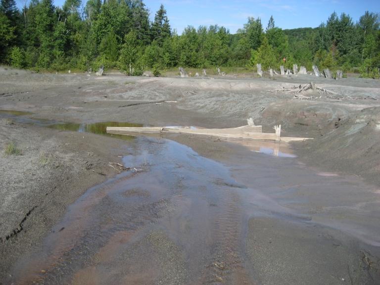
7 Central 1 and 2 Stamp Sand Areas 2009 Lesson Learning Experience Worked with Keweenaw Historical Society to preserve stamp sand Design was based on a theory that copper levels were high in the stream due to erosion Moved the stream into areas deemed less likely to erode and designed the stream accordingly Rathbun, 2010 Central 1 after construction


8 Central 2010 Data Central 1 copper data came back with considerable surface water reductions Central 2 copper data came back with minimal surface water reductions This finding lead to the design of a groundwater study which found: Copper levels in groundwater were 7-10 times higher than surface water samples Conditions exist within groundwater to dissolve copper and keep it mobile ph in groundwater is below 7 Oxygen is at or near zero High levels of dissolved and total organic carbon Because of groundwater conditions the only maintenance free remediation solution is to remove the stamp sand from groundwater Ringuette, 2009 Kotke, 2010 Kotke, 2010
9 General Groundwater Cycle

10 Copper Contamination in Groundwater In groundwater copper and copper minerals dissolve which then enter the stream Copper impacts small organisms Humans require relatively large amounts of copper as an essential mineral in their diet Toxicity to humans is low Uses include vitamin supplements, cosmetics, drinking water pipes and money Kotke, 2012


11 Creating a Natural System from a Moonscape Reznick, 2012


12 Pre-Design Strategy Develop a list of outcomes Lower copper levels No maintenance No stamp sand in stream Develop a subsurface investigation using pre-determined boring transects to examine: Groundwater elevation Soil type of native material above and below the finished products elevation For stamp sand projects - focus remediation on the area where stamp sand is in contact with groundwater

")
13 Aerial Photos and Reference Reaches Look at many decades of aerial photos and maps using GIS to understand what has happened in the watershed over time Do not use impacted areas as reference reaches At a minimum get 6 cross sections on riffles The distance between each elevation measurement should be a minimum 3 inches and max 12 inches Longitudinal profile of reach Pebble count or protrusion height (where riffles are wood, sand dunes, or large boulders and bedrock) at riffles


14 Classify soils using USCS classification system or equivalent Properly recording soil and its physical properties is very important for construction purposes (Geotechnical): Must classify soils with depths, thickness, saturation, and compaction Lab sieve analysis may be needed for proper classification

15 Groundwater contours Native soil contours


16 Put The Thoughts on Paper Develop technical group Drawings do not need to be accurate as they convey a concept Start to finalize plans at 50% drawings Major issues must be discussed and resolved in committee Small tweaks after 75% drawing 100% must meet all project goals

17 Central 2 Reconstruction 2012 Getting Stabilized, Naturally! Kotke, 2012


18 Insta-Tree Reznick, 2012 Reznick, 2012 Reznick, 2012 Technique uses on-site vegetation Has zero cost for mature vegetation which usually has significant costs Provides instant riparian stabilization when applied correctly Uses shrubs and small trees which have a greater chance of survival Still may require some maintenance the following year


19 Natural Structures Used at Central 2 Reznick, 2012 Reznick, 2012 Reznick, 2012 Wood veins can be used to redirect flow or constrict flow during low flow events to maintain sediment transport Proper use of boring information can be used to identify whether riffles can form naturally or whether other means are needed For large elevation changes or areas that do not have proper sediment types, wood can be used to create drop structures which replicates log jams and when properly designed can accommodate fish passage


20 Central 2 Reconstruction 2012 Fall 2012 Initial Data Kotke, 2012 Reznick, 2012 Reznick, 2012 Copper levels one month after construction had very little change from pre-construction numbers Copper levels two months after construction showed a significant drop in surface water copper concentrations. Further data is scheduled for collection in 2013

21 What s Next? Cliff Mine


22 Project Partners Houghton/Keweenaw Conservation District Natural Resource Conservation Services Keweenaw County Road Commission MD Contracting Keweenaw Historical Society Michigan Technical University MSHDA - State Historic Preservation Office Michigan Department of Environmental Quality U.S. Environmental Protection Agency


23 Thank You! Questions? Chad Kotke Department of Environmental Quality Water Resources Division Nonpoint Source Unit