YOU AND PHOSPHORUS. Wisconsin Lake Leaders 2008
|
|
|
- Amanda Rodgers
- 5 years ago
- Views:
Transcription
1 YOU AND PHOSPHORUS Wisconsin Lake Leaders 2008
2 Making a Positive Connection Between Land and Lake Wisconsin Lake Leaders 2008
3 Why do we care about P? FISH Water Quality Zooplankton Bacteria Algae N U T R I E N T S WATER


4 Add a little extra P to a lake, and you can make a lot of algae -
 10-20 Medium (Mesotrophic) Greater than 20 High")
5 Phosphorus Concentration (mg/l) Productivity 10 Low (Oligotrophic) Medium (Mesotrophic) Greater than 20 High (Eutrophic)
6 Let s think about the water!
7 THE WISCONSIN WATER STORY
8 NET WATER BUDGET 12
9
10 Do you see any phosphorus here?
11 Assume a 300 shoreline zone And 300 acre lake Likens and Bormann, 1995 (Biogeochemistry Of a Forested Ecosystem); Schlesinger, 1991 (Biogeochemistry); Wetzel, 2001 (Limnology). 300 acre 25 mean depth 15 ug/l TP 300 acre Circular Lake 200 mg/kg soil P 100 lb/acre P
12 How much phosphorus in the Lake? 300 lbs (water) Likens and Bormann, 1995 (Biogeochemistry Of a Forested Ecosystem); Schlesinger, 1991 (Biogeochemistry); Wetzel, 2001 (Limnology). 300 acre 25 mean depth 15 ug/l TP 300 acre Circular Lake 200 mg/kg soil P 100 lb/acre P
13 How much phosphorus in the Land? 40,000 lbs+/- Likens and Bormann, 1995 (Biogeochemistry Of a Forested Ecosystem); Schlesinger, 1991 (Biogeochemistry); Wetzel, 2001 (Limnology). 300 acre 25 mean depth 15 ug/l TP 300 acre Circular Lake 200 mg/kg soil P 100 lb/acre P

14 Phosphorus can be used and reused and reused and reused
15 Usually low concentrations in water that has moved through soil ~20 mg/l
16 Water running Off the land Has much higher concentrations ~1000 mg/l
17
18 Lots of phosphorus in soils & vegetation Lots of water moving through land to water Amount of phosphorus transferred depends on the path the water takes Direct, surface runoff conveys much more phosphorus than infiltrating water
19 Lake Phosphorus (ug/l) Lake Phosphorus Conc (mg/l) Phosphorus Transfer Rate (pounds/acre/year)


20 How do we increase P transfer? Impervious surfaces Compact soil Open/bare soil Shape to the lake and stream


21 How do we increase P transfer? Impervious surfaces Compact soil Open/bare soil Shape to the lake and stream
22 Let s Follow the Water Rainfall
23 Rain
24 Runon: Water from adjacent impervious surfaces
25 Infiltration: water entry into a pervious surface
26 Ponding: water arrives faster than it can infiltrate
27 Surface Runoff: horizontal movement of ponded water (after surface storage satisfied)
28 The Rain 32 Inches per Year +/- 100 storms per year +/- 500 hours of precipitation (>trace) per year +/-
29 Hours / Year Inches / Hour Based on P8 hourly rainfall File for 36 years, Madison
30 Hours / Year ¼ inch/hour Inches / Hour Based on P8 hourly rainfall File for 36 years, Madison
31 Hours / Year ½ inch/hour Inches / Hour Based on P8 hourly rainfall File for 36 years, Madison
32 Hours / Year ½ inch/hour 1 inch/hour Inches / Hour Based on P8 hourly rainfall File for 36 years, Madison
33
34 Water Infiltration & Movement At higher moisture contents, more (..most) of the water is moving in the larger openings (pores) Low Moisture High Moisture
35 Factors Controlling Water Movement Pore Size and Texture Coarse soils can have more larger pores Clay Loam Loamy Sand
36 Factors Controlling Water Movement Pore Sizes: Macropores When very large pores are present ( macropores ), They can dominate flow at high moisture content Clay Loam Loamy Sand
37 Factors Controlling Water Movement Soil Structure Aggregations of soil particles with larger openings between Less Structure More Structure
38 Example Infiltration Rates Sand 2 to more than 10 inches/hour Silt Loam 0.2 inches/hour to 1 inch/hour Clay 0.03 to 0.3 inch/hour
39 Reducing Infiltration Rates
40 Factors Controlling Water Movement Raindrop Impact Terminal velocity of mph can break up structure. Small particles washed into openings forms surface seal and dries to form surface crust
41 Factors Controlling Water Movement Compaction Move aggregates or particles together, reduce porosity increase bulk density Uncompacted Compacted
42 Factors Controlling Water Movement Compaction Condition Ponded Infiltration Rate (in/hr) Vegetated 3.4 Open Soil 0.7 Silt loam soil described by Vervoort, R.W., S.M. Dabney and M.J.M. Romkens Tillage and Row Position Effects on Water and Solute Infiltration Characteristics, Soil Science Society of America Journal 65: Traffic 0.1

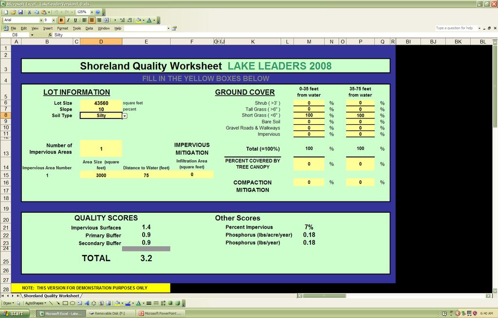
43 Runoff Infiltration Experiments
44 Flow (liter/second) Inches / 10 min 0.2 Rain Minutes 1000 ft 2 roof 1/2 inch rain in 1 hour Runoff from Roof Hours
45 Flow (liter/second) Hours 1 /hr 2 Wide 10 Long
46 Flow (liter/second) Hours 2 /hr 2 Wide 10 Long
47 Flow (liter/second) Hours 50% Runoff 10 /hr 2 Wide 10 Long
48 Flow (liter/second) Hours 25% Runoff 20 /hr 2 Wide 10 Long
49 Rainfall Intensity Runon Volume Infiltration Rate Geometry & Slope
50 Fraction of Runon That Runs Off " 0.5" ¼ - ½ inch/hour " 0.1" Infiltration Rate (in/hr) Runon Ratio 500 / 5(w) x 40 (L). The fraction of runon to the secondary buffer that would infiltrate for different storm sizes and infiltration rates (assumes a 500 ft2 impervious area draining to a five foot wide channel, forty feet long and one hour storm of depth shown). Dashed lines show the fitted equation based on soil infiltration rate and storm depth.

51 Estimating Your Phosphorus Footprint
52 Impervious surfaces Infiltration characteristics Infiltration Devices
53 Impervious surfaces Infiltration characteristics Infiltration Devices Runoff Volume Estimate Runoff Concentration Estimate
54 Rainfall
55 Rainfall
56 Fraction of Runon That Runs Off " 0.5" ¼ - ½ inch/hour " 0.1" Infiltration Rate (in/hr) Runon Ratio 500 / 5(w) x 40 (L). The fraction of runon to the secondary buffer that would infiltrate for different storm sizes and infiltration rates (assumes a 500 ft2 impervious area draining to a five foot wide channel, forty feet long and one hour storm of depth shown). Dashed lines show the fitted equation based on soil infiltration rate and storm depth.
57 Percent Infiltrated Sand Silt Clay Percent of the Average Year Percent Infiltrated = 150 * (Fraction Imp)^( ln Infil Rate ) 40 0% 5% 10% 15% 20% 25% 30% 35% Raingarden Size (% of Impervious) Percentage of the annual average rainfall infiltrated for different infiltration area sizes (shown as a percentage of the impervious area) for sand, fine sand, silt and clay. The symbols show the results of individual RECARGA simulations, the dashed lines show the single-soil best fit, and the solid lines show the single-equation fit (equation shown on the figure)for all textures.
58
59
60
61
62
63 Shrinking Our Footprint

64 Reduce Runoff Generation Reduce Impervious Area Promote High Infiltration Rates in Pervious Areas
65 Infiltrate Runoff Generated Allow water to spread out (take advantage of infiltration geometry and don t channelize) Impound where possible (raingardens, trenches) Promote High Infiltration Rates in Pervious Areas
66 Infiltrate Runoff Generated Don t compact Don t shape to lake No bare soil Don t make it easy for the water to get to the lake
67 Stay-tuned there is still a lot we don t know Micro-topography Winter FUTURE Other considerations
68 THANKS Thanks to many folks from the WDNR (Buzz, Tim, Carroll, Steve, Gregg ) from Lake Groups, Counties, UWExtension & UWSP (Bob, Patrick, Tiffany, Nancy ), Graduate Students (Kaylea, Darrin, Adam )
69 Paul McGinley (715) College of Natural Resources SUMMARY
70
71 How do we decrease P transfer? Vegetation Don t compact Don t channelize Don t shape to the lake Direct impervious surface runoff to infiltration areas
72 12 inches water on 1 square mile in a year ~ 31 million seconds in a year = 28 Million Cubic Feet Of water each year = almost 1 cubic foot of water every second -- every square mile!
73 Summary
74 Let s Follow the Water Rainfall Infiltrate
75 Assume a 300 shoreline zone And 300 acre lake Likens and Bormann, 1995 (Biogeochemistry Of a Forested Ecosystem); Schlesinger, 1991 (Biogeochemistry); Wetzel, 2001 (Limnology). 300 acre 25 mean depth 15 ug/l TP 300 acre Circular Lake 200 mg/kg soil P 100 lb/acre P
76 How much phosphorus in the Lake? 300 lbs (water) Likens and Bormann, 1995 (Biogeochemistry Of a Forested Ecosystem); Schlesinger, 1991 (Biogeochemistry); Wetzel, 2001 (Limnology). 300 acre 25 mean depth 15 ug/l TP 300 acre Circular Lake 200 mg/kg soil P 100 lb/acre P
77 How much phosphorus in the Land? 40,000 lbs+/- Likens and Bormann, 1995 (Biogeochemistry Of a Forested Ecosystem); Schlesinger, 1991 (Biogeochemistry); Wetzel, 2001 (Limnology). 300 acre 25 mean depth 15 ug/l TP 300 acre Circular Lake 200 mg/kg soil P 100 lb/acre P
78 Comparing Lake and Land 40,000 lbs+/- 300 lbs (water) Likens and Bormann, 1995 (Biogeochemistry Of a Forested Ecosystem); Schlesinger, 1991 (Biogeochemistry); Wetzel, 2001 (Limnology). 300 acre 25 mean depth 15 ug/l TP 300 acre Circular Lake 200 mg/kg soil P 100 lb/acre P


79 RECALL --- Back of the envelope comparison groundwater versus surface runoff 1 mg/l 0.02 mg/l 2.7 pound/acre/yr 0.05 pound/acre/yr Assumes 12 inches runoff
80 Fraction of Runon That Runs Off " 1 0.5" " 0.1" Infiltration Rate (in/hr) Runon Ratio 500 / 5(w) x 40 (L). The fraction of runon to the secondary buffer that would infiltrate for different storm sizes and infiltration rates (assumes a 500 ft2 impervious area draining to a five foot wide channel, forty feet long and one hour storm of depth shown). Dashed lines show the fitted equation based on soil infiltration rate and storm depth.
81 Fraction of Runon That Runs Off " 0.5" ¼ - ½ inch/hour " 0.1" Infiltration Rate (in/hr) Runon Ratio 500 / 5(w) x 40 (L). The fraction of runon to the secondary buffer that would infiltrate for different storm sizes and infiltration rates (assumes a 500 ft2 impervious area draining to a five foot wide channel, forty feet long and one hour storm of depth shown). Dashed lines show the fitted equation based on soil infiltration rate and storm depth.
82 Design Infiltration Areas

83 Infiltration Device Designed to facilitate the entry and movement of precipitation or runoff into or through the soil Here shown with increased surface storage capacity
84 Make it hard for the water to get to the lake
85 SUMMARY Make it hard for the water to get to the lake
86 SUMMARY No compaction No shaping for drainage No bare soil
87 SUMMARY No compaction No shaping for drainage No bare soil
88 Slow it down & Infiltrate SUMMARY
89 Slow it down & Infiltrate SUMMARY
90 Challenges The baseline may be low Treatment for phosphorus probably not as efficient as TSS How do you measure the extent to which this impervious is connected?
91 Lake Phosphorus (ug/l) Lake Phosphorus Conc (mg/l) Phosphorus Transfer Rate (pounds/acre/year)
92 Lake Phosphorus (ug/l) Lake Phosphorus Conc (mg/l) Phosphorus Transfer Rate (pounds/acre/year) Large Watershed/Lake Ratio
93 Lake Phosphorus (ug/l) Lake Phosphorus Conc (mg/l) Phosphorus Transfer Rate (pounds/acre/year) Small Watershed/Lake Ratio

94 Lake Phosphorus (ug/l) Lake Phosphorus Conc (mg/l) Phosphorus Transfer Rate (pounds/acre/year)
95 Lakes
96 FISH Water Quality


97 This water is always moving!
98 FISH Water Quality Zooplankton Bacteria Algae

99 FISH Water Quality Zooplankton Bacteria Algae WATER
100
 on the")
101 How do we keep all this water (and nutrients) on the land
102 Fraction of Runon That Runs Off " 0.5" ¼ - ½ inch/hour " 0.1" Infiltration Rate (in/hr) Runon Ratio 500 / 5(w) x 40 (L). The fraction of runon to the secondary buffer that would infiltrate for different storm sizes and infiltration rates (assumes a 500 ft2 impervious area draining to a five foot wide channel, forty feet long and one hour storm of depth shown). Dashed lines show the fitted equation based on soil infiltration rate and storm depth.