DRAFT. Hood River County. Multi-Jurisdictional Natural Hazards Mitigation Plan. Hood River County and the Cities of Cascade Locks and Hood River
|
|
|
- Norman Haynes
- 5 years ago
- Views:
Transcription


1 Hood River County Multi-Jurisdictional Natural Hazards Mitigation Plan Hood River County and the Cities of Cascade Locks and Hood River Prepared for: Hood River County Emergency Management Department 601 State Street Hood River, OR Prepared by: University of Oregon s Community Service Center: Resource Assistance for Rural Environments & Department of Land Conservation and Development 1209 University of Oregon Eugene, Oregon Capitol St. NE #150 Salem, OR June 2018
2
3 Special Thanks & Acknowledgements Hood River County developed this Natural Hazards Mitigation Plan through a regional partnership funded by the Federal Emergency Management Agency s Pre-Disaster Mitigation Competitive Grant Program. FEMA awarded the Mid-Columbia Gorge Region grant to support the update of natural hazards mitigation plans for eight counties in the region. The region s planning process utilized a four-phased planning process, plan templates and plan development support provided by Resource Assistance for Rural Environments (RARE) and the University of Oregon s Community Service Center. This project would not have been possible without technical and financial support provided by the Department of Land Conservation and Development. Regional partners include: Department of Land Conservation and Development Oregon Emergency Management FEMA Region X University of Oregon s Community Service Center Resource Assistance for Rural Environments at the University of Oregon s Community Service Center Project Steering Committee: John Roberts, Hood River County Community Development Mikel Diwan, Hood River County Public Works Mike Schrankel, Hood River County GIS Coordinator Loretta Duke, US Forest Service Theresa North, Columbia Area Transit Mike McCafferty, Hood River Fire Defense Board Mike Matthews, Public Health Manager, Hood River County Public Health Catherine Dalbey, Director of Human Resources, Hood River County School District Michael McElwee, Port of Hood River Gordon Zimmerman, City of Cascade Locks Paul Koch, Port of Cascade Locks Dustin Nilsen, City of Hood River Barbara Ayers, Hood River County Emergency Management Project Managers: Barbara Ayers, Director, Hood River County Emergency Management Nicolia Mehrling, Resource Assistance for Rural Environments
4 Community Service Center Staff: Megan Smith, Director, Resource Assistance for Rural Environments; Co-Director, Community Service Center Michael Howard, Assistant Program Director, Community Service Center Titus Tomlinson, Program Coordinator, Resource Assistance for Rural Environments Aniko Drlik-Mueheck, Project Coordinator, Community Service Center Julie Foster, Grants Administrator, Community Service Center Geographic Information Systems (GIS) Maps: Mike Schrankel, Hood River County GIS Oregon HazVu, Oregon Department of Geology and Mineral Industries Plan Template Disclaimer This Natural Hazards Mitigation Plan is based in part on a plan template developed by the University of Oregon Community Center (Oregon Partnership for Disaster Resilience.) The template is structured to address the requirements contained in 44 CFR 201.6; where language is applicable to communities throughout Oregon, OPDR encourages the use of standardized language. As part of this regional planning initiative, OPDR provided copies of the plan templates to communities for use in developing or updating their natural hazards mitigation plans. OPDR hereby authorizes the use of all content and language provided to Hood River County in the plan template. About the Community Service Center The Community Service Center (CSC), a research center affiliated with the Department of Planning, Public Policy, and Management at the University of Oregon, is an interdisciplinary organization that assists Oregon communities by providing planning and technical assistance to help solve local issues and improve the quality of life for Oregon residents. The role of the CSC is to link the skills, expertise, and innovation of higher education with the transportation, economic development, and environmental needs of communities and regions in the State of Oregon, thereby providing service to Oregon and learning opportunities to the students involved. About the Oregon Partnership for Disaster Resilience The Oregon Partnership for Disaster Resilience (OPDR) is a coalition of public, private, and professional organizations working collectively toward the mission of creating a disasterresilient and sustainable state. Developed and coordinated by the Community Service Center at the University of Oregon, the OPDR employs a service-learning model to increase community capacity and enhance disaster safety and resilience statewide. About Resource Assistance for Rural Environments RARE is an AmeriCorps program administered through the University of Oregon's Community Service Center. RARE is currently supported through grants from the Corporation for National & Community Service (AmeriCorps), The Ford Family Foundation, the University of Oregon, the Oregon Food Bank, the Federal Emergency Management Agency, the Oregon Department of Transportation, and other agencies. In addition, each
5 participating community provides $19,000 of approximately $32,000 needed to place, train, and support a full-time RARE member.
6 This page left intentionally blank.
7 Hood River County Natural Hazards Mitigation Plan Table of Contents Volume I: Basic Mitigation Plan Executive Summary... i Section 1: Introduction Section 2: Risk Assessment Section 3: Mission, Goals, and Action Items Section 4: Plan Implementation and Maintenance Volume II: Hazard Annexes Drought... HA-2 Earthquake... HA-4 Flood... HA-10 Wildland Fire... HA-13 Landslide... HA-16 Severe Local Storm... HA-18 Tornadoes... HA-22 Volcanoes... HA-24 Volume III: Jurisdictional Addenda City of Cascade Locks Addenda..CLA -1 City of Hood River Addenda.HRA -1 Volume IV: Mitigation Resources Appendix A: Action Item Forms... A-1 Appendix B: Planning and Public Process... B-1 Appendix C: Community Profile... C-1 Appendix D: Economic Analysis... D-1 Appendix E: Region Hazard Mitigation Public Opinion Survey... E-1 Appendix F: Grant Programs... F-1
8 Executive Summary Hood River County developed this Natural Hazards Mitigation Plan in an effort to prepare for the long term effects resulting from natural hazards. This plan was developed for Hood River County. It is impossible to predict exactly when these hazards will occur, or the extent to which they will affect the community. However, with careful planning and collaboration among public agencies, private sector organizations, and citizens within the community, it is possible to create a resilient community that will benefit from long-term recovery planning efforts. The Federal Emergency Management Agency (FEMA) defines mitigation as... the effort to reduce loss of life and property by lessening the impact of disasters... through risk analysis, which results in information that provides a foundation for mitigation activities that reduce risk. Said another way, natural hazard mitigation is a method of permanently reducing or alleviating the losses of life, property, and injuries resulting from natural hazards through long and short-term strategies. Example strategies include policy changes, such as updated ordinances; projects, such as seismic retrofits to critical facilities; and education and outreach to targeted audiences, such as Spanish speaking residents or the elderly. Natural hazard mitigation is the responsibility of the Whole Community - individuals, private businesses and industries, state and local governments, and the federal government. Why Develop this Mitigation Plan? In addition to establishing a comprehensive community-level mitigation strategy, the Disaster Mitigation Act of 2000 (DMA2K) and the regulations contained in 44 CFR 201 require that jurisdictions maintain an approved NHMP in 44 CFR The local mitigation plan is the representation of the jurisdiction s commitment to reduce risks from natural hazards, serving as a guide for decision makers as they commit resources to reducing the effects of natural hazards CFR 201.6(a)(1) A local government must have a mitigation plan approved pursuant to this section in order to receive HMGP project grants... order to receive federal funds for mitigation projects. Local and federal approval of this plan ensures that the county and listed cities will remain eligible for pre- and post-disaster mitigation project grants. Who Participated in Developing the Plan? The Hood River County Natural Hazards Mitigation Plan is the result of a collaborative effort between the county, cities, special districts, citizens, public agencies, non-profit organizations, the private sector and regional organizations. A project steering committee
9 guided the plan development process. The project steering committee included representatives from the following organizations. Hood River County Community Development Hood River Soil and Water Conservation District Hood River County School District Hood River County Environmental Health Services Hood River Fire Department Hood River County Public Works City of Cascade Locks Administration City of Hood River Planning Hood River County Emergency Management Oregon Department of Transportation Bonneville Power Administration United States Forest Service Hood River County Community Development convened the planning process and will take the lead in implementing, maintaining and updating the plan. Public participation played a key role in the development of goals and action items. At various stages during the plan update s development, county officials and the public were invited to learn of its progress and to comment on completed sections. This took place primarily during presentations before the county board of commissioners, but city officials were also given a chance to comment on the plan development during scheduled meetings throughout the update process, when cities were offered a chance to join the process as separate jurisdictions. The public was also given a chance for further involvement in the plan update process when 1,200 surveys were randomly mailed to Hood River County residents using voter registration records. The survey was meant to gauge the priorities of the public in terms of government efforts to address natural hazards, but also contained questions that gauged the public s knowledge and awareness of the county s current plan, and thus served an additional purpose as an informational outreach tool. Finally, when a working draft of the updated plan was completed it was posted online for public comment. Members of the general public were invited to view, critique, and otherwise express any concerns they may have had with the plan update, and these comments were addressed during the final plan editing process. How Does this Mitigation Plan Reduce Risk? This natural hazard mitigation plan is intended to assist Hood River County reduce the risk from natural hazards by identifying resources, information, and strategies for risk reduction. It 44 CFR 201.6(c)(1) Documentation of the planning process used to develop the plan, including how it was prepared, who was involved in the process, and how the public was involved. 44 CFR 201.6(c)(2) A Risk Assessment that provides the factual basis for activities proposed in the strategy...
10 is also intended to guide and coordinate mitigation activities throughout the county. A risk assessment consists of three phases: hazard identification, vulnerability assessment, and risk analysis, as illustrated in the following graphic. Figure i.1 Understanding Risk Source: OPDR By identifying and understanding the relationship between natural hazards, vulnerable systems, and existing capacity, communities in Hood River County are better equipped to identify and implement actions aimed at reducing the overall risk to natural hazards. What is the County s Overall Risk to Hazards? Hood River County conducted a risk assessment to evaluate the probability of each hazard as well as the vulnerability of the community to that hazard. Table i.1 below presents the overall risk assessment for Hood River County including both the county s hazard analysis and relative risk. The hazards are listed in rank order from high to low, taking consideration of past historical events, vulnerability to populations, the maximum threat, and the probability, or likelihood of a particular hazard event occurring. Table i.1: Risk Assessment Summary Hazard History Probability Vulnerability Maximum Threat Total Rank Risk Level Winter Storm High Wildfire High CSZ Event Medium Landslide Medium Drought Medium
11 Flood Medium Crustal Earthquake Medium Windstorm Medium Volcano Low Source: Hood River County Risk Assessment Steering Committee Meeting, March 29, 2018 What is the Plan s Mission? The mission of the Hood River County Natural Hazards Mitigation Plan is to, Protect life, property and the environment through coordination and cooperation among public and private partners, which will reduce risk and loss, and enhance the quality of life for the people of Hood River County. What are the Plan Goals? The plan goals describe the overall direction that the participating jurisdiction s agencies, organizations, and citizens can take toward mitigating risk from natural hazards. Hood River County s plan goals include: Protection of Life, Property, and Natural Resources Disaster Resilient Economy Education and Outreach Facilitate Partnerships and Coordination Acknowledge Responsibility Emergency Services Enhancement How are the Action Items Organized? The action items are organized within an action item matrix (located in Section 3 of the plan), which lists all of the multi-hazard and hazardspecific action items included in the mitigation plan. Data collection, research and the public participation process resulted in the development of the action items. The Action Item Matrix portrays the overall plan framework and identifies linkages between the plan goals and actions. The matrix documents the title of each action along with the coordinating organization, timeline, and the plan goals addressed. Action items are further detailed in individual action item forms located in Appendix A of the plan. How will the plan be implemented? 44 CFR 201.6(c)(3)(i) A description of mitigation goals to reduce or avoid long-term vulnerabilities to the identified hazards. 44 CFR 201.6(c)(3)(ii) A section that identifies and analyzes a comprehensive range of specific mitigation actions CFR 201.6(c)(3)(iii) An action plan describing how the actions... will be prioritized, implemented and administered CFR 201.6(c)(4) A plan maintenance process...
12 The plan maintenance section of this plan details the formal process that will ensure that the Hood River County Natural Hazards Mitigation Plan remains an active and relevant document. The plan will be implemented, maintained and updated by a designated convener. The convener is responsible for overseeing annual review processes. Cities and special districts developing addendums to the county plan will also designate a convener and will work closely with the county convener to keep the plans coordinated. The plan maintenance process includes a schedule for monitoring and evaluating the plan annually and producing a plan revision every five years. This section describes how the communities will integrate public participation throughout the plan maintenance process. Plan Adoption After the plan is locally reviewed and deemed complete the Director of Hood River County Emergency Management submits it to the State Hazard Mitigation Officer at Oregon Emergency Management. Oregon Emergency Management reviews the plan and submits it to the Federal Emergency Management Agency (FEMA Region X) for review. This review will address the 44 CFR 201.6(c)(5) Documentation that the plan has been formally adopted by the governing body of the jurisdiction CFR 201.6(d) Plan review [process]... federal criteria outlined in FEMA Interim Final Rule 44 CFR Part Once the plan is preapproved by FEMA, the county formally adopts the plan via resolution. The individual jurisdiction s conveners will be responsible for ensuring local adoption of the Hood River County Natural Hazards Mitigation Plan and providing the support necessary to ensure plan implementation. Once the resolution is executed at the local level and documentation is provided to FEMA, the plan is formally acknowledged by FEMA and the county gains (or maintains) eligibility for the Pre-Disaster Mitigation Grant Program, the Hazard Mitigation Grant Program funds, and the Flood Mitigation Assistance program funds. The accomplishment of the Natural Hazards Mitigation Plan goals and actions depends upon the maintenance of a competent Steering Committee and adequate support from the county and city departments reflected in the plan in incorporating the outlined action items into existing county plans and procedures. It is hereby directed that the appropriate county departments and programs implement and maintain the concepts in this plan. Thorough familiarity with this Plan will result in the efficient and effective implementation of appropriate mitigation activities and a reduction in the risk and the potential for loss from future natural hazard events.
13 This page left intentionally blank.
14 This page left intentionally blank.
15 This page left intentionally blank.
16 Section 1: Introduction This section provides a general introduction to natural hazard mitigation planning in Hood River County. In addition, Section I: Introduction addresses the planning process requirements contained in 44 CFR 201.6(b) thereby meeting the planning process documentation requirement contained in 44 CFR 201.6(c)(1). The section concludes with a general description of how the plan is organized. What is Natural Hazard Mitigation? The Federal Emergency Management Agency (FEMA) defines mitigation as... the effort to reduce loss of life and property by lessening the impact of disasters... through risk analysis, which results in information that provides a foundation for mitigation activities that reduce risk. Said another way, natural hazard mitigation is a method of permanently reducing or alleviating the losses of life, property, and injuries resulting from natural hazards through long and short-term strategies. Example strategies include policy changes, such as updated ordinances; projects, such as seismic retrofits to critical facilities; and education and outreach to targeted audiences, such as Spanish speaking residents or the elderly. Natural hazard mitigation is the responsibility of the Whole Community - individuals, private businesses and industries, state and local governments, and the federal government. Engaging in mitigation activities provides jurisdictions with a number of benefits, including reduced loss of life, property, essential services, critical facilities and economic hardship; reduced short-term and long-term recovery and reconstruction costs; increased cooperation and communication within the community through the planning process; and increased potential for state and federal funding for recovery and reconstruction projects. Why Develop a Mitigation Plan? Hood River County updated this Natural Hazards Mitigation Plan in an effort to reduce future loss of life and damage to property resulting from natural hazards. This plan applies to both the cities and unincorporated regions of Hood River County. It is impossible to predict exactly when natural hazard events will occur, or the extent to which they will affect community assets. However, careful planning and collaboration among public agencies, private sector organizations, and citizens within the community, can minimize the losses that can result from natural hazards. In addition to establishing a comprehensive community-level mitigation strategy, the Disaster Mitigation Act of 2000 (DMA2K) and the regulations contained in 44 CFR 201 require that jurisdictions maintain an approved NHMP in order to receive federal funds for
17 mitigation projects. Local and federal approval of this plan ensures that the county and listed cities will remain eligible for pre- and post-disaster mitigation project grants. What Federal Requirements Does This Plan Address? The Disaster Mitigation Act of 2000 (DMA2K) is the latest federal legislation addressing mitigation planning. It emphasizes planning for natural hazards before they occur. As such, this Act established the Pre-Disaster Mitigation (PDM) grant program and new requirements for the national post-disaster Hazard Mitigation Grant Program (HMGP). Section 322 of the Act specifically addresses mitigation planning at the state and local levels. State and local jurisdictions must have approved mitigation plans in place in order to qualify to receive post-disaster HMGP funds. Mitigation plans must demonstrate that their proposed mitigation measures are based on a sound planning process that accounts for the risk to the individual and State and local jurisdictional capabilities. Chapter 44 Code of Federal Regulations (CFR), section 201.6, also requires a local government to have an approved mitigation plan in order to receive HMGP project grants. 1 Pursuant of Chapter 44 CFR, the Natural Hazard Mitigation Plan planning processes shall include opportunity for the public to comment on the plan during review, and the updated Natural Hazard Mitigation Plan shall include documentation of the public planning process used to develop the plan. 2 The Natural Hazard Mitigation Plan update must also contain a risk assessment, mitigation strategy and a plan maintenance process that has been formally adopted by the governing body of the jurisdiction. 3 Lastly, the Natural Hazard Mitigation Plan must be submitted to Oregon Military Department Office of Emergency Management (OEM) for initial plan review, and then federal approval. 4 Additionally, a recent change in the way OEM administers the Emergency Management Performance Grant (EMPG), which helps fund local emergency management programs, also requires a FEMA-approved NHMP. These four subsections address plan requirements, the planning process, plan content, and plan review. Subsection (a) provides an outline of the overall plan requirements, including an overview of general plan components, exceptions to requirements, and multijurisdictional participation. Subsection (b) outlines the requirements of the planning process, with particular focus on public involvement in the update process, as well as the role of local agencies, organizations and other relevant entities in the development process, as well as standards for adequate levels of review and incorporation of existing plans and policies. Subsection (c) outlines requirements concerning the plan update s content, including an overview of necessary components for the update s planning process, risk assessment, mitigation strategy, plan maintenance, and overall process documentation. Subsection (d) outlines the steps and agencies required for proper review of the plan before finished plans are adopted by their respective communities. 1 Code of Federal Regulations, Chapter 44. Section 201.6, subsection (a), ibid, subsection (b) ibid, subsection (c) ibid, subsection (d). 2015
18 What is the Policy Framework for Natural Hazards Planning in Oregon? Planning for natural hazards is an integral element of Oregon s statewide land use planning program, which began in All Oregon cities and counties have comprehensive plans and implementing ordinances that are required to comply with the statewide planning goals. The challenge faced by state and local governments is to keep this network of local plans coordinated in response to the changing conditions and needs of Oregon communities. Statewide land use planning Goal 7: Areas Subject to Natural Hazards calls for local plans to include inventories, policies and ordinances to guide development in or away from hazard areas. Goal 7, along with other land use planning goals, has helped to reduce losses from natural hazards. Through risk identification and the recommendation of risk-reduction actions, this plan aligns with the goals of the jurisdiction s Comprehensive Plan, and helps each jurisdiction meet the requirements of statewide land use planning Goal 7. The primary responsibility for the development and implementation of risk reduction strategies and policies lies with local jurisdictions. However, resources exist at the state and federal levels. Some of the key agencies in this area include Oregon Emergency Management (OEM), Oregon Building Codes Division (BCD), Oregon Department of Forestry (ODF), Oregon Department of Geology and Mineral Industries (DOGAMI), and the Department of Land Conservation and Development (DLCD). How was the Plan Developed? The plan was developed by the Hood River County Natural Hazard Mitigation Plan Steering Committee and the Steering Committees for the cities of Hood River and Cascade Locks. The Hood River County Steering Committee formally convened on four occasions to discuss and revise the plan. Each of the participating city Steering Committees met at least once formally. Steering Committee members contributed data and maps, and reviewed and updated the community profile, risk assessment, action items, and implementation and maintenance plan. The following schedule was developed to provide a timeline for completion of the plan update sections, though altered accordingly throughout the year to reflect then-current levels of progress.
19 Figure 1.1: NHMP Update Timeline Stage 1 Work Session Stage 2 Work Session Stage 3 Work Session Stage 4 Work Session Stage 5 Organize Resources Risk Assessment Mission, Goals, Actions Implementation & Maintenance Final Plan Preparation February March April April May Stage 6 Plan Implementation Source: Oregon Partnership for Disaster Resilience, 2012 The first four stages of the update process had corresponding steering committee meetings, during which previous work could be reviewed and new content developed for each particular session. The first and second, and third and fourth stages were combined into long format steering committee meetings. A final draft of the plan was completed at the end of May and circulated among county officials and interested public for review before submission to FEMA for plan pre-approval. At various stages during the plan update s development, county officials and the public were invited to review progress and comment on completed sections. The public was given a chance for further involvement in the plan update process when notice was posted to city and county web platforms. Announcement of the plan update was also made to the board of county commissioners, city councils, the county rotary group, and various social service organizations. A survey was available for residents to submit, and over 30 people responded. Multiple opportunities were also provided for neighboring communities, local and regional agencies involved in hazard mitigation activities to be involved in the planning process, particularly during Hood River County NHMP Update Steering Committee meetings. Representatives from potential partner organizations and agencies were invited to join the Steering Committee responsible for reviewing and updating the county s plan early in the planning process. During early stages of the planning process, pre-existing plans, studies, reports and other technical information from Hood River County were identified and reviewed for inclusion in the updated plan. Information and policy cultivated from this review was used to inform
20 updates of the county s community profile, risk assessment and mitigation strategy sections, and listed where appropriate for general reference. How is the Plan Organized? Each volume of the mitigation plan provides specific information and resources to assist readers in understanding the hazard-specific issues facing Hood River County citizens, businesses, and the environment. Combined, the sections work in synergy to create a mitigation plan that furthers the Hood River County Emergency Management department s mission to prepare the region for large scale emergencies and disasters. This plan structure enables stakeholders to use the section(s) of interest to them. Volume I: Natural Hazards Mitigation Plan Plan Summary The plan summary provides an overview of the FEMA requirements, planning process, and highlights the key elements of the risk assessment, mitigation strategy, and implementation and maintenance strategy. Section 1: Introduction The Introduction briefly describes the countywide mitigation planning efforts and the methodology used to develop the plan. Section 2: Risk Assessment Section 2 provides the factual basis for the mitigation strategies contained in Section 3. Additional information is included in Appendix C, the Community Profile. The section includes an overview of existing plans, policies, and programs, community organizations, existing mitigation actions, and the hazards impacting Hood River County. This section allows readers to gain an understanding of each jurisdictions sensitivities, vulnerabilities, and resilience the ability to manage risk and adapt to hazard event impacts. A hazard summary is provided for each of the hazards addressed in the plan. The summary includes hazard history, location, extent, vulnerability, impacts, and probability. This NHMP addresses the following hazards: Drought Earthquake Flood Landslide Volcano Wildfire Windstorm Winter Storm
21 Additionally, this section provides information on the jurisdictions participation in the National Flood Insurance Program (NFIP). Section 3: Mitigation Strategy This section documents the plan vision, mission, goals, and actions and also describes the components that guide implementation of the identified mitigation strategies. Actions are based on community sensitivity and resilience factors and the risk assessments in Section 2 and the Hazard Annexes. Section 4: Plan Implementation and Maintenance This section provides information on the implementation and maintenance of the plan. It describes the process for prioritizing projects, and includes a suggested list of tasks for updating the plan to be completed at the semi-annual and 5-year review meetings. Volume II: Hazard-Specific Annexes The hazard annexes summarize the best available local hazard data. A hazard summary is provided for each of the hazards addressed in the plan. The summary includes hazard history, location, extent, vulnerability, impacts, and probability. Hazard summaries are taken directly from the recently updated Hood River County Hazard Identification and Vulnerability Analysis (HIVA). The hazard specific annexes included with this plan are the following: Drought; Earthquake; Flood; Wildland Fire; Landslide; Winter Storm; Windstorm; and Volcanoes Volume III: Jurisdictional Addenda Volume III of the plan is reserved for any city or special district addenda developed through this multi-jurisdictional planning process. Each of the cities within the county participated in the NHMP process and created an addendum. As such, the five-year update cycle will be the same for all of the cities and the county. This plan includes addenda for the jurisdictions of the Cities of Cascade Locks and Hood River. Volume IV: Appendices The resource appendices are designed to provide the users of the Hood River County Natural Hazards Mitigation Plan with additional information to assist them in understanding the contents of the mitigation plan, and provide them with potential resources to assist with plan implementation. Appendix A: Action Item Forms This appendix contains the detailed action item forms for the high priority mitigation strategies identified in this plan.
22 Appendix B: Planning and Public Process This appendix includes documentation of all the countywide public processes utilized to develop the plan. It includes invitation lists, agendas, sign-in sheets, and summaries of Steering Committee meetings as well as any other public involvement methods. Appendix C: Community Profile This profile can be utilized to identify specific issues locally and to develop potential action items. The data in the updated profile are based on best available local, state, and federal data. The profile includes a Natural Environmental Capacity section that details the physical geography of the county; a Socio Demographic Capacity section that discusses the population in the county; a Regional Economic Capacity section that discusses local industry, regional affordability, economic diversity, employment and wages, and an overview of labor and commute sheds; a Built Capacity section that addresses the county s housing building stock, physical infrastructure, critical facilities, utilities (including transportation and power transmission systems), dependent facilities, and correctional facilities; a Community Connectivity Capacity section that discusses the county s social organizations, cultural resources, and community stability; and lastly a Political Capital section that provides an overview of the county s government structure, and existing plans and policies. In addition to describing characteristics and trends, each profile section identifies the traits that indicate sensitivity to natural hazards. Appendix D: Economic Analysis of Natural Hazards Mitigation Projects This appendix describes the Federal Emergency Management Agency s (FEMA) requirements for benefit cost analysis in natural hazards mitigation, as well as various approaches for conducting economic analysis of proposed mitigation activities. This appendix was developed by OPDR. It has been reviewed and accepted by the Federal Emergency Management Agency as a means of documenting how the prioritization of actions shall include a special emphasis on the extent to which benefits are maximized according to a cost benefit review of the proposed projects and their associated costs. Appendix E: Grant Programs This appendix lists state and federal resources and programs by hazard.
23 Section 2: Risk Assessment This section of the NHMP addresses 44 CFR 201.6(b)(2) - Risk Assessment, and serves as the factual basis for addressing Oregon Statewide Planning Goal 7 Areas Subject to Natural Hazards. This section first assesses risk by identifying hazards that can impact the jurisdiction. Potential impacts of each hazard are evaluated according to type, location, and extent. Then, important community assets and system vulnerabilities are identified. Finally, the plan evaluates the extent to which local hazards overlap with, or have an impact on, important assets. The risk assessment process is graphically depicted in Figure 2.1 below. The ultimate goal of hazard mitigation is to reduce the potential for hazards and vulnerable systems to overlap. The information presented in this section, along with more comprehensive data located in the Hazard Annexes and the Community Profile Appendix, informs the risk reduction actions identified in Section 3 Mitigation Strategy. Figure 2.1 Understanding Risk Source: OPDR
24 Hazard Identification Hood River County is regularly impacted by six natural hazards: wildfires, winter storms, windstorms, droughts, landslides, and floods. Wildfires and winter storms are considered high priority hazards because the County is highly vulnerable to their impacts, while windstorms, droughts, landslides, and floods exist more as complicating or compounding factors. The County is also susceptible to varying degrees of risk from earthquake events and volcanic eruptions. A general overview of these hazards and their threat to Hood River County is listed below in Table 2.1. Hazard Table 2.1: Hood River County Hazard Overview General location and extent Vulnerability Ranking Drought Earthquake (CSZ and Crustal) Flood Countywide; frequent to regular moderate draughts; effect agricultural and recreational sectors. A subduction zone earthquake would collapse buildings and damage infrastructure countywide. Crustal quake events stemming from local faults could be catastrophic to County infrastructure. Rivers in Hood River County historically flood every few years. These include the Hood River, Indian Creek, Phelps Creek and the Columbia River. Flood hazard areas are along the East, Middle and West forks of the Hood River, and along Emil, Odell, Baldwin and Neal Creeks. Moderate Moderate Low Landslide Hood River County has many areas adjacent to the Columbia River Gorge where landslides have taken place; steep slopes and high precipitation increase landslide risk. Severe landslides can damage infrastructure and transportation. Moderate Volcano Hood River County may be impacted by a volcanic eruption from Mt. Hood at any time, which would impact White River, Sandy, and Hood River channels. Moderate Wildfire Windstorm The entire county is vulnerable to the effects of wildfire; however steep slopes, unmanaged forests, and wind conditions intensify risk. Transportation and economic activity is disrupted by wildfire. Windstorms are frequent throughout the County, but rarely create catastrophic damage. Moderate Moderate Winter Storm Countywide; severe winter storms occur annually and create dangerous driving conditions, residential isolation, and power outages. High Source: Hood River County Steering Committee, March 2018 The following subsections briefly describe relevant information for each hazard. For detailed information on Hood River County s natural hazards, refer to Volume II: Hazard
25 Annexes. For additional background on the hazards, vulnerabilities and general risk assessment information for hazards in the Mid-Columbia region refer to the State of Oregon NHMP, Region 5: Mid-Columbia Regional Risk Assessment. Winter Storms Hood River County is vulnerable to a variety of severe storm hazards including ice, snow, and freezing rain, which all have the ability to severely impact the county. Severe local storms seldom cause death and serious property damage but they can cause major utility and transportation disruptions. When major transportation corridors are blocked or electricity lines are damaged, residents may go without food and fuel resupply for multiple days. Winter storms occur regularly throughout the County. Ice storms occur when rain falls from warm moist upper layers of the atmosphere into a cold, dry layer near the ground. The rain freezes on contact with the cold ground and accumulates on exposed surfaces, including tree branches and power lines. This can cause power outages and can obstruct transportation routes. A snow and ice storm occurred in 2012 that caused extensive damage to regional utilities and left two inches of ice in parts of the county for several days. Winter storms in 2017 closed I-84, a transportation lifeline, for almost a week. Hood River County has had snowfall accumulations that vary depending on geographic location. Accumulations in excess of 150 inches may occur around the higher elevations of Mt. Hood, whereas in the area of the Hood River Experimental Station, average snowfall may accumulate to approximately 12 inches, depending on the year. Accumulations of snow usually increase with distance and elevation as the terrain rises to the South of the Columbia River. January is usually the month with the greatest snowfall. Wildfire Historically, the instance of wildfire is increasing throughout the Columbia Gorge region. Though small in size, Hood River County contains a diverse set of wildfire hazard and risk situations. There are several climatic and topographic conditions found in Hood River County that are conducive for large wildfires: hot and dry conditions during the fire season throughout the county; frequent high winds along the Columbia River Gorge which can contribute to fast moving fires that are difficult to control; and moderate to steep slopes in places which add to the rate of wildfire spread and suppression difficulty. Hood River County s fire season usually runs from mid-may through October. However, any prolonged period of lack of precipitation presents a potentially dangerous problem. Any instance of uncontrolled burning within a forested area is a forest fire, whereas uncontrolled burning in grassland, brush, or woodlands is classified as a wildfire. Hood River County s fire season usually runs from mid-may through October. The probability of a fire in any one locality on a particular day depends on fuel conditions, topography, time of year, past and present weather conditions, and activities (debris burning, land clearing, camping, etc.) which are or will be taking place. The effects of wildfires vary with intensity, area, and time of year. Factors affecting the degree of risk of fires include extent of rainfall, humidity, wind speed, type of vegetation, and proximity to firefighting agencies. The greatest short-term loss is the complete destruction of valuable resources, such as timber, wildlife habitat, scenic vistas, and
26 watersheds. Vulnerability to flooding increases immediately after fires due to the complete or partial destruction of affected watersheds. Long-term effects include reduced timber stands for commercial purposes and reduction of travel and recreational activities. Over the past ten years, the major fires in Hood River County for which data is available occurred in 2017 (Eagle Creek Fire Columbia Gorge National Scenic Area, 48,831 acres), 2008 (Gnarl Ridge, 3,280 acres), 2009 (Microwave, 1,224 acres), and 2011 (Dollar Lake, 6,304 acres). Home building in and near forests, referred to as interface areas, increase the risks from forest fires. Historically, it appears that the instance of wildfires is increasing in Hood River County and the region more generally. The existence of open range lands and large forested areas, increasing population and recreational activities, and the uncertain impact of a changing climate combine to increase the probability of a hazard event. The destruction of large tracts of forest land during these events have immediate economic impacts to the community through lost jobs and reduced taxes, while collateral economic and social effect can impact the county for years. Earthquake An earthquake is the shaking of the ground caused by an abrupt shift of rock along a fracture in the earth, called a fault. The entire county population, property, commerce, infrastructure and services may be vulnerable to an earthquake. Earthquake magnitude and level of preparedness in combination determine the potential scope of damage, which could range from minimal to moderate loss of life and destruction of property. Local geology demonstrates that the county has been impacted by significant earthquake events in the last 500 years. Earthquakes in Hood River County are most likely to originate from two sources: 1) the Cascadia Subduction Zone and 2) crustal faults near the eastern end of the Columbia River Gorge. A CSZ event would result in strong to very strong shaking throughout the County, and soil liquefaction in the populated areas of Hood River and Cascade Locks Cities. It is likely that the County would become isolated from fuel and food supplies in such an event, and should be prepared to receive refugees from Western Oregon. A CSZ event is predicted to occur with 37-43% probability within the next 50 years. Crustal faults are likely to produce small earthquakes; a significant event would range from 5 to 7 in magnitude. Table 2.2 lists the class A and B crustal faults that are located in or near the county. 5 Table 2.2: Class A and B Faults Located in or near Hood River County Name Class Fault ID Primary County Length (km) Time of most recent deformation Slip-rate category Faults near The Dalles A 580 Unnamed faults northwest of Condon B 814 Hood River County, Oregon Gilliam County, Oregon 69 km 22 km Quaternary (<1.6 Ma) Quaternary (<1.6 Ma) Less than 0.2 mm/yr Less than 0.2 mm/yr Oregon Natural Hazards Mitigation Plan, Mid-Columbia Region 5 Risk Assessment
27 Faults along highway 35, passing through Parkdale A 866 Blue Ridge Fault n/a n/a Hood River County, Oregon Hood River County, Oregon Quaternary Less than 0.2 mm/yr 44 km (<1.6 Ma) Between ~13,540 and 9,835 years Less than km before present mm/yr Source: U.S. Geological Survey (USGS), Quaternary Fault and Fold Database, The Dalles 1 X 2 Sheet 6 and Field- Trip Guide to Mount Hood, Oregon, Highlighting Eruptive History and Hazards ( Landslide/Debris Flow Hood River County has a history of landslides that tend to occur in isolated, sparsely developed areas. These landslides threaten individual structures and remote sections of the transportation, energy and communications infrastructure. In contrast, the landslide prone area along parts of Interstate Highway 84 from the border of Multnomah County to the City of Hood River has the potential to cause traffic accidents and damage to the region s transportation system. Landslides typically occur in Hood River County during or after periods of heavy rain and flooding. The term landslide includes a wide range of ground movement, such as rock falls, deep failure of slopes, and shallow debris flows. Slides in Hood River County generally range in size from thin masses of soil of a few yards wide to deep-seated bedrock slides. Slide velocity ranges from a few inches per month to many feet per second, depending largely on slope, material, and water content. Dormant slide masses can be reactivated by earthquakes or unusually wet winters. Because ancient slide masses consist of broken materials and disrupted ground water, they are more susceptible to construction-triggered sliding than adjacent undisturbed material. It is most common for landslides to occur on water saturated slopes when the base of the slope can no longer support the weight of the soil above it. Landslides are commonly associated with heavy rain and flooding conditions, but they may also be associated with earthquakes and with volcanic activity. The period from December 1996 to February 1997, which saw intense winter storms, included a number of landslides in Hood River County. Drought A history of drought within the region has periodically threatened the county s populations and natural resources, and during dry years, the entire population of the county is vulnerable. Of particular concern with regard to drought potential are the non-irrigated areas around the county, especially farms. Drought is defined by climatic dryness severe enough to reduce soil moisture and water below the minimum amount necessary for sustaining plant, animal, and human life systems. Hood River County has suffered from extended drought conditions regularly, and nearly all areas of Hood River County may be vulnerable to drought. Significant droughts occurred in 2005 and 2015, and droughts impacted neighboring counties in 2008, 2013, and 2014 as well.
28 Water shortages impact the agricultural industry, especially farmer owners. Droughts also lead to increased danger of wildfires, which has consumed millions of board feet of timber in past years. In many cases, subsequent erosion has caused heavy silting of streams, reservoirs, and rivers. Low stream flows have also damaged fish resources by creating high temperatures, oxygen depletion, and disease. Due to these effects, droughts create economic and revenue losses for business, cities and the county as a whole. The entire population of the county is vulnerable to the effects of drought, though transportation and communications infrastructure would be minimally impacted, if at all. As growth places more pressure on limited local resources, future impacts may be greater. 6 Water management programs have been most effective in minimizing the impacts of droughts. Flood Historically, flooding has occurred along one or more of the county s waterways every few years. These include the Hood River, Indian Creek, Phelps Creek and the Columbia River. Flood hazard areas are along the East, Middle and West forks of the Hood River, and along Emil, Odell, Baldwin and Neal Creeks. Flooding on the Columbia River typically occurs during May, June, and July due to melting snowpack, whereas flooding of the other rivers and creeks in Hood River County usually occurs between October and March. Long periods of heavy rainfall and mild temperatures coupled with snowmelt contribute to flooding conditions. The main cause of Northwest floods is the moist air masses that regularly move over the region in the winter. In Hood River County, the weather that produces the most serious flooding events are extensive wet conditions that follow a period of mid and high elevation ice and snow pack development. The county is susceptible to both riverine and flash floods. Wind Storm Strong winds that impact Hood River County comes from two sources. Frequent and widespread strong winds come from the west and are associated with storms moving onto the coast from the Pacific Ocean. Strong west winds may also arise from a pressure differential when high atmospheric pressure occurs above the upper Columbia River Basin and low pressure above the Pacific Ocean. The Columbia River Gorge acts as a funnel, concentrating the intensity of the winds as they flow from the West. This generates frequent strong winds throughout the Gorge and at its outlet. No recorded instance of a tornado causing damage in Hood River County is available, but the conditions to produce a tornado do occur. Volcanic Event A volcano is a vent in the earth s crust through which molten rock, rock fragments, gases or ashes are ejected from the earth s interior. There are a wide variety of hazards related to volcanoes and volcano eruption. Mount Hood is a potentially active volcano close to rapidly growing communities and recreation areas. The most likely widespread and hazardous consequence of a future eruption will be for lahars (rapidly moving mudflows) to sweep 6 Hood River County Strategic Preparedness Planning, Hazard Identification and Vulnerability Analysis, Updated November, 2011
29 down the entire length of the Sandy (including the Zigzag) and White River valleys. Lahars can be generated by hot volcanic flows that melt snow and ice or by landslides from the steep upper flanks of the volcano. Structures close to river channels are at greatest risk of being destroyed. The degree of hazard decreases as height above a channel increases, but large lahars can affect areas more than 30 vertical meters (100 vertical feet) above river beds. Cascade Range volcanoes in the U.S. have erupted more than 200 times during the past 12,000 years for an average of nearly two eruptions per century. At least five eruptions have occurred during the past 150 years. The most recent eruptions in the Cascade Range are the well-documented eruptions of Mt. St. Helens, which claimed 57 lives and caused nearly a billion dollars in damage and response costs. FEMA Declarations President Dwight D. Eisenhower approved the first federal disaster declaration in May 1953 following a tornado in Georgia. Since then, federally declared disasters have been approved within every state. As of March 2018, FEMA has approved a total of 32 federal disaster declarations, two emergency declarations and 69 fire management assistance declarations in Oregon. 7 When requesting a presidential declaration for a major disaster or emergency, governors provide detailed information about the amount of value of public and private property damage resulting from the event. FEMA uses these damage assessments to determine if the event meets the disaster declaration threshold, the amount of federal public and private assistance made available, as well as the specific counties to be included in the declaration. Disaster declarations inform hazard mitigation project priorities by demonstrating and documenting which hazards have historically caused the most significant damage to the county. Table 2.3 summarizes the seven major disasters declared for Hood River County by FEMA since The table shows that all of the major disaster declarations in Hood River County have been flood, landslide and weather related. Table 2.3: FEMA Major Disaster Declarations for Oregon Hood River County Declaration Number: DR-4328 DR-4055 DR-1672 Declaration Date: 7-Jan-17 2-Mar Dec-06 Incident(s): Severe Storms, Flooding, Landslides, and Mudslides Severe Winter Storm, Flooding, Landslides, and Mudslides Severe Storms, Flooding, Landslides, and Mudslides DR Feb-04 Severe Winter Storms Incident(s) Period: 07-Jan-17 to 10-Jan Jan-12 to 21-Jan-12 5-Nov-06 to 8-Nov Dec-03 to 14-Jan- 04 Individual Assistance: None None None None Public Assistance Categories: A, B, C, D, E, F, G A, B, C, D, E, F, G A, B, C, D, E, F, G A, B, C, D, E, F, G 7 FEMA. Declared Disasters by Year or State. Accessed March 8, 2012
30 DR-1099 DR Feb Jan-74 Severe Storms, Flooding Severe Storms, Snowmelt, Flooding 4-Feb-96 to 21-Feb Jan-74 DR Dec-64 Heavy Rain, Flooding 24-Dec-64 Yes Yes Yes A, B, C, D, E, F, G A, B, C, D, E, F, G A, B, C, D, E, F, G Source: FEMA, Oregon Disaster History, Major Disaster Declarations Community Vulnerability Natural disasters occur as a predictable interaction among three broad systems: natural environment (e.g., climate, rivers systems, geology, forest ecosystems, etc.), the built environment (e.g., cities, buildings, roads, utilities, etc.), and societal systems (e.g., cultural institutions, community organization, business climate, service provision, etc.). A natural disaster occurs when a hazard impacts the built environment or societal systems and creates adverse conditions within a community. Communities can minimize losses from disaster events by identifying distinct vulnerabilities and addressing them with deliberate planning and mitigation. 8 Populations 9 The socio-demographic qualities of the community population such as language, race and ethnicity, age, income, and educational attainment are significant factors that can influence the community s ability to cope, adapt to and recover from natural disasters. Historically, 80 percent of the disaster burden falls on the public. 10 Of this number, a disproportionate burden is placed upon special needs groups, particularly children, the elderly, the disabled, minorities, and low-income persons. Population vulnerabilities can be reduced or eliminated with proper outreach and community mitigation planning. Population Vulnerabilities 28% of Hood River County s population five years and older speaks a language other than English at home, and that half of this group, 15% of the total population, does not speak English well % of Hood River County residents speak Spanish. According to 2016 census estimates, persons 65 and older made up 13.7% of the total Hood River County population. An increase is expected; this group is predicted to make up 22.1% of the county s population by Children constitute over a quarter of the population in Hood River County; children are more vulnerable and require assistance in emergency situations. 8 State of Oregon Emergency Management Plan, NHMP Region 5: Mid-Columbia, February Hood River County Strategic Preparedness Planning, Hazard Identification and Vulnerability Analysis, Updated November, Hazards Workshop Session Summary #16, Disasters, Diversity, and Equity, University of Colorado, Boulder (2000). 11 U.S. Census Bureau, American Community Survey 5-year Estimates; American Fact Finder 12 Source: Social Explorer Table T7; ACS 2016 (5-Year Estimates); U.S. Census Bureau
31 According to 2016 census estimates 1,556, or 6.7%, of Hood River County noninstitutionalized citizens are living with a disability. 13 These disabilities may or may not be permanent. Hood River County contains high numbers of mobile homes (10.8%) and vacant housing (13.8%) which are less likely to be prepared for disaster situations % of the Hood River County adult population and 20.1% of residents under 16 years-old live below the poverty level. 15 The growing employment industries (manufacturing, leisure/hospitality/recreation, and education/health services) provide the lowest wages in the county. Non-English speaking and special cultural characteristics A lack of ability to speak or read English presents a challenge to emergency managers, since instructions for self-protective action and general disaster information is often exclusively in English. The non-english speaking population relies on assistance from friends or service providers to translate instructions and information. In certain areas of Hood River County, it may be advisable for emergency managers and emergency response agencies to arrange for translation of disaster related information. Transient Population The transient population is defined as those who do not have a permanent residence in Hood River County, yet are likely to be present during a hazard situation. Due to its proximity to the Columbia River and Mt. Hood, Hood River County is considered a major Northwest visitor destination, and the transient population peaks during weekends and summer months. USGS estimates 2 million and 5 million tourists annually visit the Columbia Gorge and Mt. Hood, respectively. Travelers and visitors are particularly vulnerable to disasters because they are often unfamiliar with the hazards in the region and do not have the knowledge or the materials needed to care for themselves in a disaster. For example, a typical visitor may be unfamiliar with evacuation routes or shelter locations. Light traveling visitors may not have access to supplies of food, water, flashlights, radios, and other items that locals prepare for disaster situations. Furthermore, visitors usually do not have a local support structure of family, friends, and neighbors to rely on. Low Income Insufficient financial resources during and after disasters prevent lower-income populations from coping with and recovering from disasters. This vulnerable population is also more likely to live in homes that are more susceptible to damage from flooding, windstorms, and severe weather. 13 US Census Bureau, American Community Survey 5-Year Estimates, American FactFinder, S U.S. Census Bureau, American Community Survey, 5 year Estimates, , American Fact Finder 15 U.S. Census Bureau, Small Area Estimates Branch, 2005 Estimates, 2010 Estimates and ACS 2016 (5-Year Estimates) (SE), ACS 2016 (5-Year Estimates), Social Explorer Tables T114, T115, and T116; U.S. Census Bureau
32 Table 2.6: Hood River County Population Vulnerabilities Hood River County Population Vulnerabilities Drought Winter Storm Wind Storm Earthquake Landslide Volcano Flood Wildfire High density/assisted living centers HR care center, Ashley Manor, Brookside Assisted Living, Parkhurst, Down Manor, Hawks Ridge, Dethman Manor, Taylor St. special needs home Hood River Hospital, Dialysis Unit Schools X X Special needs populations i.e. wheelchair, bed ridden, etc X X Hospice, Home health X X Hotels/motels located in Columbia River Floodplain Downtown cores (Cities of Hood River and Cascade Locks) X X X X Parkdale and other County sub-divisions X X X X X Summer home populations (unidentifiable) X X X X X Unregistered assisted living homes X X X Migrant worker housing X X X Public staff: limited and variable commutes X X X X X Source: Hood River County Risk Assessment Steering Committee Meeting, March 29, 2018 Economy Hood River County is susceptible to economic disturbance from Natural Hazards, as a majority of funding for county services and a substantial amount of the region s income come from timber sales and agriculture, which can be severely disrupted by drought, flood, fire and winter storms, hazards with a high likelihood of probability across the entire county. Another primary economic driver in the County is tourism and recreation, which can be disrupted during winter storms and wildfires. Furthermore, disruption to I-84 or the Union Pacific railroad impact the local, regional, and statewide economy. Specific issues concerning the county s economy that were identified in the County s Risk Assessment Steering Committee Meeting are outlined in Table 2.7 below, along with the hazards that are most likely to impact them. The unemployment rate in Hood River County is low, and major economic drivers are gradually diversifying; however a significant amount of jobs are in lower wage industries. Many essential government staff commute to work, and a hazard event could easily disrupt the staffing capacity of emergency and government services. 39.6% of people who work in Hood River County work elsewhere; blocked transportation routes would interfere with normal economic activity. X X X X
33 Table 2.7: Hood River County Economic Issues Hood River County Economic Issues Unregistered businesses Agriculture X X X Ski Lodges and Lifts X X X Inter-state bridges X X X Port and buildings along river X X BPA Power lines X X Airport County forest land (primary revenue source) X X Small business community Drought Winter Storm Tourism infrastructure X X Trail infrastructure X X X X Source: Hood River County Risk Assessment Steering Committee Meeting, March 29, 2018 Land-use and Development To accommodate growth and development, communities engaged in mitigation planning should address infrastructure, service needs, specific engineering standards and building codes. Eliminating or limiting development in hazard prone areas, such as floodplains, can reduce vulnerability to hazards, and the potential loss of life, injury, and property damage. Communities in the process of developing land for housing and industry need to ensure that land use and protection goals are being met to prevent future risks. 16 Overall, strong policies and plans in place to guide land use and development within the County. Specific issues concerning the county s land use and development that were identified in the county s Risk Assessment Steering Committee Meeting are outlined in Table 2.8 below, along with a list of hazards that are most likely to impact them. The County is experiencing significant population growth. Hood River County is a rural county, and some areas are developing to urban densities. Table 2.8: Hood River County Land Use and Development Issues Hood River County Land Use Assets Development in wildfire susceptible areas Building codes X X X Drought Winter Storm Wind Storm Wind Storm Earthquake Earthquake Landslide Landslide Volcano Volcano Flood Flood X Wildfire X Wildfire 16 State of Oregon Emergency Management Plan, Region 5: Mid-Columbia Regional Profile, February 2012
34 Flood plain ordinances (migrating channels not addressed) Development in Port Areas (liquefaction risk) Source: Hood River County Risk Assessment Steering Committee Meeting, March 29, 2018 X X Environment With four distinct mild seasons, a diverse terrain and its proximity to the Columbia Gorge, Hood River County has historically dealt with habitual drought, flooding, wildfires and the occasional landslide. By identifying potential hazards, temperature and precipitation patterns, along with natural capitals such as key river systems, Hood River County can focus on key areas to better prepare, mitigate, and increase the resiliency of local communities. 17 Specific and general county-wide environmental concerns along with the hazards that are most likely to impact them are listed in Table 2.9 below. Table 2.9: Hood River County Environmental Issues Hood River County Environmental Issues Two golf courses one on Indian Creek X X Drinking water resources X X Odell Creek chemical storage facility on Odell Highway X X Waste water facilities near Odell and Columbia River X X X Tucker park and Toll Bridge park X X X State and National Parks X X X X Forested areas X X X X Hood River (irrigation and fish resources) X X Source: Hood River County Risk Assessment Steering Committee Meeting, March 29, 2018 Critical Facilities and Infrastructure Transportation networks, systems for power transmission, and critical facilities such as hospitals and police stations are all vital to the functioning of a county. Due to the fundamental role that infrastructure plays both pre and post disaster, it deserves special attention in the context of creating more resilient communities. 18 Specific and general county-wide critical infrastructure and services concerns along with the hazards that are most likely to impact them are listed in Table 2.10 below. A few transportation corridors are integral to food and fuel access, economic recovery, and staff mobility, including the Interstate 84 and two interstate bridges. Most of the people and infrastructure are along the I-84 corridor, which runs along the northern portion of the Drought Winter Storm Wind Storm Earthquake Landslide Volcano Flood Wildfire 17 Hood River County NHMP Community Profile, State of Oregon Emergency Management Plan, Region 5: Mid-Columbia Regional Profile, February 2012
35 region. This multimodal transportation corridor includes a major interstate highway (I-84); two transcontinental rail lines, Union Pacific and Burlington Northern Santa Fe; the Columbia River inland water navigation; major electric power and gas lines; and communication conduits. These lifelines are susceptible to disruption by natural hazards, especially winter storms, wildfires, and earthquake events. Power-generating facilities and water systems in the County are diverse and numerous, increasing resiliency in face of a hazard event. Local drinking water is supplied by wells, springs, and surface water, and as such is susceptible to erosion, pollution and sediment in a disaster. Table 2.10: Hood River County Critical Infrastructure and Services Issues Structure Address City Type Comments Hood River County Gorge Radio-Bicoastal Media Columbia River nd Street Hood River Communications Hood River County 911 CenturyLink (phone and internet - hub- County bldg) BPA Powerlines and Towers BPA dam and hydroelectric plabt 601 State Street, 3rd floor Hood River Communications 601 State Street, 2nd floor Hood River Communications Multnomah Just west of Hood County River County line Electric Mt. Hood Just west of Hood River County line Hood River Dam and ekectric Pacific Power Substations 12th and 13th Street Electric Hood River Electric Hood River, Cooperative 3521 Davis Street Odell, Parkdale Electric Fish Food Bank Tucker Rd; Odell County Food Northwest Natural Gas Various gas lines and meters County, Hood across River, Cascade community Locks Fuel Ace Hardware, Hood River Supply 3831 Eagle Loop County (Odell) Chrevron Odell Gas 3387 Odell Station Highway County (Odell) Fuel Pine Grove Pit Stop 2385 OR-35 County (Pine Fuel Essential services - County Essential services - County and EOC dependency Lifeline to County and region Critical to power grid and vulnerable in earthquake Lifeline to Odell volatile gas lines in emergencies
36 Grove) Hood River County Public Works (City/County fuel supply) th Street Hood River 616 Industrial St # 401 Hood River Fuel Fuel - emergnency svcs 76 gas station Valero gas station 101 N 1st St Hood River Fuel Chevron downtown 2555 Cascade Ave Hood River Fuel Astro fuel 214 Front Street Hood River Fuel Carson Oil 2660 Dock Road Hood River Fuel Harvey's Texaco 3450 Cascade Ave Hood River Fuel Chevron waterfront 949 E Marina Dr Hood River Fuel Nobi's Gas Station 1380 Tucker Road Hood River Fuel County Administration, Board of Commissioners, EOC 601 State Street Hood River Government WyEast Fire District ( Van Horn Unincorporated Government stations - 1 in Odell, 1 in Drive, 3431 Odell Pine Grove) Hwy Hood River County 309 State Street Hood River Government Sherriffs Office, Courthouse, parole and probation, juvenile, D.A. Parkdale Fire District (3 fire stations - 2 in Mt Baseline Hood, 1 in Dee) Drive Mt. Hood Government Back-Up EOC: Intertribal 4270 WestCliff Fisheries Enforcement Drive Hood River Government County Public Works th Street Hood River Government 4250 Barrett Westside RFPD -1 Drive Hood River Government Westside RFPD Tucker Road Hood River Government 3000 Wyeast Wy'East Middle School Road County (Odell) School essential service essential services essential services essential service essential service Possible shelter site Hood River Airport County Transportation Bonneville Dam n/a Cascade Locks Infrastructure The Dalles Dam n/a The Dalles Infrastructure Union Pacific Railway waterfront adjacent to I-84 Countywide County Transportation Extreme danger if combusted or Hood River-White Salmon Interstate Bridge 1000 E Port Marina Drive Hood River Transportation derailed Gas line on bridge Bridge of the Gods Cascade Locks Transportation I-84 Managed by County Transportation Lifeline
37 Highway 35 Crystal Springs Water ODOT Managed by ODOT County Transportation Lifeline 3006 Chevron Drive Odell Water Ice Fountain Water 1185 Tucket Road Hood River Water Odell Water 3641 Davis Drive Odell Water Parkdale Water Parkdale Water Dee Bridge Lost Lake Road County WA Highway 14 (Managed by WSDOT) City of Cascade Locks Power Utility (2 substations) Bridge of the Gods (Port of Cascade Locks) Bonneville Power Administration Columbia Market Thunder Island Brewery Chevron Gas Station Shell Gas Station Cascade Locks Fire District City Hall, Public Works Port Facilities City Water and Sewer Marine Park Historical Houses ODOT Cascade Locks Water City of HR main water line attached to bridge SR 14 Klickitat County, WA Washington Transportation Lifeline. Critical transportation cooridor if I- 84 closes City of Cascade Locks 140 SW Wanapa Street Cascade Locks Electric Electric 450 Wa Na Pa Street Cascade Locks Food 515 SW Portage Rd Cascade Locks Food 437 Wa Na Pa Street Cascade Locks Fuel 425 Wa Na Pa Street Cascade Locks Fuel 25 Wa Na Pa Street Cascade Locks Government 140 SW Wanapa Street Cascade Locks Government 427 SW Portage Road Cascade Locks Government 140 SW Wanapa Street Cascade Locks Sanitary 427 SW Portage Road Cascade Locks Government 427 SW Portage Road Cascade Locks Cultural essential service lifeline essential service essential service essential service essential service essential service essential
38 station Hood River Distillery City of Hood River 660 Riverside Drive Hood River Business service Extreme danger if combusted Ace Hardware, Hood River Supply th St Hood River Fuel, hardware Astro Gas Station 214 Front Street Hood River Fuel Valero Gas Station 101 N 1st Street Hood River Fuel Shell Gas Station th Street Hood River Fuel 1108 E Marina Shell Gas Station Drive Hood River Fuel Height's Fuel Stop th Street Hood River Fuel 949 E Marina Chevron Gas Station 1 Drive Hood River Fuel 2555 Cascade Chevron Gas Station 2 Avenue Hood River Fuel Hood River-White 1000 E Port Salmon Interstate Bridge Marina Drive Lifeline fuel and supplies Hood River Transportation Lifeline. Gas line on bridge; Hood River County Public Works (City/County fuel supply) th Street Hood River Fuel - emergnency svcs Havey's Texaco Gas Station 3450 Cascade Ave Hood River Fuel Union 76 Gas Station 1650 Tucker Road Hood River Fuel 616 Industrial St # 76 gas station 401 Hood River Valero gas station 101 N 1st St Hood River Chevron downtown 2555 Cascade Ave Hood River Astro fuel 214 Front Street Hood River Carson Oil 2660 Dock Road Hood River Harvey's Texaco 3450 Cascade Ave Hood River Chevron waterfront 949 E Marina Dr Hood River Hood River Police, Hood River City Council and Adminstration 211 2nd Street Hood River Government Port Facilities - Administration, Marina 1000 E Port Marina Drive Hood River Government can strand commuters and motorists if closed essential service Essential services Liquefaction area. What port facilities are most
39 critical? City of Hood River Fire 1785 Meyer Parkway Hood River Government Hood River City Hall 211 2nd Street Hood River Government City Public Works, Building water and sewer th Street Hood River Government Columbia Gorge Community College - Hood River 1730 College Way Hood River Government Providence Hood River Memorial Hospital th Street Hood River Health One Community Health and Radio Tierra 849 Pacific Ave Hood River Health, Communications Hood River Garbage and 3440 Guignard Recycling Drive Hood River Sanitary Hood River Middle School 1602 May Street Hood River School Hood River Waste Water Plant 818 Riverside Drive Hood River Sewage City of Hood River Water District (Public Works) th Street Hood River Water Essential services Essential services Essential services Possible shelter site Essential services Bilingual outreach and community hub Possible shelter site Liquefaction area; essential services Essential services 2249 Cascade Safeway Avenue Hood River Food Lifeline Rosauer's Supermarket th Street Hood River Food Lifeline 2700 Wasco Walmart Street Hood River Food Juanita's Market th Street Hood River Food Source: Hood River County Risk Assessment Steering Committee Meeting, March 29, 2018 National Flood Insurance Program (NFIP) Lifeline in emergencies Hood River County s Flood Insurance Rate Maps are current as of September, 1984, making them some of the oldest FIRMs in the state. Table 2.11 shows that as of February, 2018, there were a total of 32 National Flood Insurance Program (NFIP) policies in force with a total coverage value of $9.8 million. Between 1978 and February, 2018, there were three NFIP claims including one in Cascade Locks, and two others in unincorporated areas across Hood River County.
40 Table 2.11: NFIP Summary Table Jurisdiction Hood River County Unincorporat ed Hood River Cascade Locks FIRM Status ALL ZONE A,C,X- NO ELEVATION DETERMINED ALL ZONE A,C,X- NO ELEVATION DETERMINED ALL ZONE A,C,X- NO ELEVATION DETERMINED ALL ZONE A,C,X- NO ELEVATION DETERMINED FIRM Date Sep- 84 Sep- 84 Sep- 84 Sep- 84 NFIP Status^ # NFIP Policies Total Coverage # NFIP Claims Total Paid P 32 $9,822,900 3 $29,616 P 26 $8,024,900 2 $26,139 P 3 $980, P 3 $818,000 1 $3,477 Source: Oregon Department of Land Conservation and Development, Planning Services Division. Received from Dave Lentzner, March 2018; ^ P = Participating, NP = Not Participating Table 2.12 illustrates that as of February, 2018, Hood River County and its incorporated cities have zero repetitive flood loss properties. There have been no Community Assistance Visits in Hood River County. Neither Hood River County nor its incorporated cities are members of the Community Rating System (CRS). The National Flood Insurance Program s (NFIP) Community Rating System (CRS) is a voluntary incentive program that recognizes and encourages community floodplain management activities that exceed the minimum NFIP requirements. 19 Participation in the program typically results in discounted flood insurance premium rates that reflect the reduced flood risk from community actions to meet CRS goals. Table 2.12: NFIP Repetitive Loss and Severe Repetitive Loss Summary Jurisdiction Source: State NFIP Coordinator Risk Assessment # SRL Properties- Validated # SRL Properties- Pending # RL Properties Hood River County Cascade Locks Hood River TOTALS To develop a more comprehensive understanding of the risks facing Hood River County from natural hazards, a ranking system was developed by members of the Hood River County NHMP Steering Committee. A vulnerability score (described in Table 2.13 and its preceding paragraph) was combined with a probability score (described in Table 2.4 and its preceding paragraph) plus two other variables (event history and maximum threat) to develop a total threat score for each hazard. The scores were used for strategic preparedness planning and 19 Federal Emergency Management Agency, National Flood Insurance Program, Community Rating System, Accessed: May 30, 2012
41 to justify the prioritization of individual natural hazards in the action item section of Hood River County s Natural Hazard Mitigation Plan. Multi-jurisdictional Risk Assessment (c) (2) (iii): For multi-jurisdictional plans, the risk assessment must assess each jurisdiction s risks where they vary from the risks facing the entire planning area. Cascade Locks and the City of Hood River participated in County Steering Committee meetings and completed a jurisdiction specific hazard analysis; for more information on the process see Appendix B. City specific information is presented in Volume II, Jurisdictional Addenda. For local governments, conducting the hazard analysis is a useful step in planning for hazard mitigation, response, and recovery. The method provides the jurisdiction with a sense of hazard priorities, but does not predict the occurrence of a particular hazard. At the Hood River County Risk Assessment Steering Committee Meeting on March 29, 2018, Severity Impact scores were developed by steering committee members to represent the potential impact of various natural hazards to general health and safety (by potential deaths and injuries), facilities (by physical damage and costs), and community (by expected economic, ecologic and social interruption). Hazard Analysis Methodology The hazard analysis methodology in Oregon (primarily to inform Emergency Operations Planning) was first developed by FEMA circa 1983, and gradually refined by the Oregon Military Department s Office of Emergency Management over the years. The methodology produces scores that range from 24 (lowest possible) to 240 (highest possible). Vulnerability and probability are the two key components of the methodology. Vulnerability examines both typical and maximum credible events, and probability endeavors to reflect how physical changes in the jurisdiction and scientific research modify the historical record for each hazard. Vulnerability accounts for approximately 60% of the total score, and probability approximately 40%. We include the hazard analysis summary here to ensure consistency between the EOP and NHMP. The Oregon method provides the jurisdiction with a sense of hazard priorities, or relative risk. It doesn't predict the occurrence of a particular hazard, but it does "quantify" the risk of one hazard compared with another. By doing this analysis, planning can first be focused where the risk is greatest. In this analysis, severity ratings, and weight factors, are applied to the four categories of history, vulnerability, maximum threat (worst-case scenario), and probability as demonstrated below. History (Weight Factor = 2) History is the record of previous occurrences. Events to include in assessing history of a hazard in different jurisdictions are events for which the following types of activities were required: The Emergency Operations Center (EOC) or alternate EOC was activated; Three or more Emergency Operations Planning (EOP) functions were implemented, e.g., alert & warning, evacuation, shelter, etc.;
42 An extraordinary multi-jurisdictional response was required; and/or A "Local Emergency" was declared. LOW = 0 to 1 event in the past 100 years, scores between 1 and 3 points MODERATE = 2 to 3 event in the past 100 years, scores between 4 and 7 points HIGH = 4+ events in the past 100 years, scores between 8 and 10 points Probability (Weight Factor = 7) Probability is the likelihood of future occurrence within a specified period of time. LOW = one incident likely within 75 to 100 years, scores between 1 and 3 points MODERATE = one incident likely within 35 to 75 years, scores between 4 and 7 points HIGH = one incident likely within 10 to 35 years, scores between 8 and 10 points Vulnerability (Weight Factor = 5) Vulnerability is the percentage of population and property likely to be affected under an average occurrence of the hazard. LOW = < 1% affected, scores between 1 and 3 points MODERATE = 1-10% affected, scores between 4 and 7 points HIGH = > 10% affected, scores between 8 and 10 points Maximum Threat (Weight Factor =10) Maximum threat is the highest percentage of population and property that could be impacted under a worst-case scenario. LOW = < 5% affected, scores between 1 and 3 points MODERATE = 5-25% affected, scores between 4 and 7 points HIGH = > 25% affected, scores between 8 and 10 points Table 2.14 presents the overall risk assessment for Hood River County including both the county s hazard analysis and relative risk. The hazards are listed in rank order from high to low, taking consideration of past historical events, vulnerability to populations, the maximum threat, and the probability, or likelihood of a particular hazard event occurring. The data show that winter storm is the highest ranked hazard in the county, followed somewhat closely by wildfire. A Cascadia Subduction Zone event, landslide, and drought are similarly ranked as medium risk. Flood and crustal earthquake events come in as slightly lower risk, followed by windstorm. Volcano makes up the two lowest ranked hazards in the county overall in terms of relative risk. Table 2.14: Risk Assessment Summary Hood River County Hazard History Probability Vulnerability Maximum Threat Total Rank Risk Level Winter Storm High Wildfire High CSZ Event Medium Landslide Medium
43 Drought Medium Flood Medium Crustal Earthquake Medium Windstorm Medium Volcano Low Source: Hood River County Risk Assessment Steering Committee Meeting, March 29, 2018 Jurisdiction Specific Risk Assessment Multi-jurisdictional Risk Assessment (c) (2) (iii): For multi-jurisdictional plans, the risk assessment must assess each jurisdiction s risks where they vary from the risks facing the entire planning area. The two incorporated cities in Hood River County: Cascade Locks and Hood River completed a jurisdiction specific hazard analysis. The multi-jurisdictional risk assessment information is located within the Risk Assessment section of each jurisdiction s addendum, which is located in Volume II of this NHMP.
44 Section 3: Mission, Goals, and Action Items This section of the NHMP addresses 44 CFR 201.6(c)(3) Mitigation Strategy. The information provided in Section 2 and the Hazard Annexes provide the basis and justification for the mitigation actions identified in this plan. This section provides information on the process used to develop a mission, goals and action items. This section also includes an explanation of how the County intends to incorporate the mitigation strategies outlined in the plan into existing planning mechanisms and programs such as the County comprehensive land use planning process, capital improvement planning process, and building codes enforcement and implementation Mitigation Plan Mission Hood River County s overall vision and mission is, Providing quality of life for all. The 2006 NHMP used this as the guiding principle when developing the NHMP mission. For this update, the plan s Hood River County NHMP Steering Committee reviewed and reaffirmed the NHMP mission at its Mitigation Strategy Meeting on 29 March, The mission of the Hood River County Natural Hazard Mitigation Plan is to: Protect life, property and the environment through coordination and cooperation among public and private partners, which will reduce risk and loss, and enhance the quality of life for the people of Hood River County. Mitigation Plan Goals The plan goals help guide the direction of future activities aimed at reducing risk and preventing loss from natural hazards. The goals listed here serve as checkpoints as agencies and organizations begin implementing mitigation action items. Each goal has a series of statements which further reflect and more clearly define the goals. Background Soliciting community input during stakeholder interviews was a critical aspect of initial goal development. Armed with Stakeholder Interview input, the mitigation plan goals and goal statements were drafted by the NHMP Coordinator using assistance from OPDR during the creation of the Hood River County NHMP in The draft goals were brought before the 2006 Hood River County Steering Committee for review and approval. The goals were revised with Steering Committee input before adoption by the committee. In an effort to prioritize goals, each member of the Steering Committee was asked to (i) identify three statements that were most important to them and (ii) speak to why they
45 chose those statements. Their statement choices were tallied and goals prioritized by the number of statements selected; goals with the most statements selected are ranked in priority from I-II. This exercise was not meant to exclude the importance of the other goals, but rather assist in the implementation of this plan by identifying which of the high priority risk reducing action items to pursue funding for first. Goal Update Process The 2018 Hood River County NHMP Steering Committee reviewed the plan goals during its Risk Assessment Meeting on 29 March, The committee revised the language of some of the statements in all of the plan goals, and removed one goal, Natural Resources Protection, because it was seen to be included in Protection of Life and Property. Revisions continued to be collected and incorporated between meetings. The goals were then reaffirmed and re-prioritized during the NHMP Steering Committee Mitigation Strategy Meeting on 24 April, 2018 by vote. The committee decided that the goals should continue to be listed in order of their new level of priority. The outcome of the goal review and re-prioritization process is represented in Table 3.1 below. The PRIORITY column identifies the principal goals to serve as a starting point in the implementation of mitigation activities for Hood River County. This priority is based on the accumulation of votes for each goal by Steering Committee members. The primary goals identified are the Protection of Life & Property, Facilitate Partnerships & Coordination, and Emergency Services Enhancement. The secondary goals are Education and Outreach efforts and Disaster Resilient Economy. Table 3.1: Hood River County NHMP Goals Goal Statement Priority Prioritize increasing the resilience of County infrastructure, roads, and railways through mitigation activities Protection of Life, Property, and Natural Resources Evaluate county guideline/codes and permitting processes in addressing hazard mitigation Develop and implement activities to protect human life, commerce, property and natural resource systems Link forest, agriculture, and watershed planning, natural resource management, and land use planning with natural hazard mitigation activities I Facilitate Partnerships & Coordination Emergency Services Enhancement Strengthen communication and coordination of public/private partnerships and emergency services among local, county and regional governments, volunteers, and the private sector Create clear roles and expectations within partnerships Enhance resilience of emergency response services, critical facilities and core infrastructure to natural hazards Minimize life safety issues II III
46 Develop and implement education programs to increase awareness, partnership, and action among citizens, local, county, and regional agencies, non-profit organizations, businesses, and industry Education & Outreach Develop and conduct outreach programs to increase hazard preparedness, planning, and mitigation in high risk and/or vulnerable areas, as well as in primary industries (agriculture and tourism) Disaster Resilient Economy Leverage cross-sector partnerships to support small business environment through all stages of emergency management Address high volume seasonal tourism and I-84 transportation corridor risks in hazard planning and protect recreation and tourism industries by raising awareness of potential hazard impacts Acknowledge Local Responsibility Coordinate programs to increase natural hazard knowledge base Research policies impacting local vulnerability and resilience and advocate for statewide policy change when appropriate Acknowledge financial costs of mitigation actions and pursue funding sources Educate county leadership and incorporate hazard mitigation as part of the county s routine decision making process Source: Hood River County NHMP Steering Committee, 2018 Mitigation Plan Action Items Short and long-term action items identified through the planning process are an important part of the mitigation plan. Action items are detailed recommendations for activities that local departments, citizens and others could engage in to reduce risk. They address both multi-hazard (MH) and hazard-specific issues. Action items can be developed through a number of sources. The figure below illustrates some of these sources. A description of how the plan s mitigation actions were developed is provided below.

47 Figure 3.1 Action Item Sources Source: Partnership for Disaster Resilience, 2006 The majority of the action items were first created during the previous NHMP planning processes. All actions were reviewed by the Steering Committee, discussed at length, and revised as necessary before becoming a part of this document. Priority Actions Action items identified through the planning process are an important part of the mitigation plan. Action items are detailed recommendations for activities that local departments, citizens, and others could engage in to reduce risk. Due to resource constraints, Hood River County and participating cities are listing a set of high priority actions in an effort to focus attention on an achievable set of high leverage activities over the next five-years. This plan identifies priority actions based on an evaluation of high impact hazards, resource availability and FEMA identified best practices. Note 1: See Volume II, Jurisdictional Addenda, for the Priority Actions for each participating city. Action Item Worksheets Each high priority action item has a corresponding action item worksheet describing the activity, identifying the rationale for the project, identifying potential ideas for implementation, and assigning coordinating and partner organizations. The action item worksheets can assist the community in pre-packaging potential projects for grant funding.
48 The worksheet components are described below. These action item worksheets are located in Appendix A. Background Action items should be fact-based and tied directly to issues or needs identified throughout the planning process. Action items can be developed at any time during the planning process and can come from a number of sources, including participants in the planning process, noted deficiencies in local capability, or issues identified through the risk assessment. The rationale for proposed action items is based on the information documented in Section 2 and the Hazard Annexes. Ideas for Implementation The ideas for implementation offer a transition from theory to practice and serve as a starting point for this plan. This component of the action item is dynamic, since some ideas may prove to not be feasible, and new ideas may be added during the plan maintenance process. Ideas for implementation include such things as collaboration with relevant organizations, grant programs, tax incentives, human resources, education and outreach, research, and physical manipulation of buildings and infrastructure. Implementation through Existing Programs Many of the Hood River County Natural Hazards Mitigation Plan s recommendations are consistent with the goals and objectives of the county s existing plans and policies. Where possible, Hood River County will implement the Natural Hazard Mitigation Plan s recommended actions through existing plans and policies. Plans and policies already in existence often have support from local residents, businesses, and policy makers. Many land-use, comprehensive, and strategic plans get updated regularly, and can adapt easily to changing conditions and needs. 20 Implementing the Natural Hazard Mitigation Plan s action items through such plans and policies increases their likelihood of being supported and implemented. Coordinating Organization The coordinating organization is the public agency with the regulatory responsibility to address natural hazards, or that is willing and able to organize resources, find appropriate funding, or oversee activity implementation, monitoring and evaluation. Internal and External Partners: The internal and external partner organizations listed in the Action Item Worksheets are potential partners recommended by the project Steering Committee but not necessarily contacted during the development of the plan. The coordinating organization should contact the identified partner organizations to see if they are capable of and interested in participation. Internal partner organizations are departments within the county or other participating jurisdiction that may be able to assist in the implementation of action items by providing relevant resources to the coordinating organization. 20 Burby, Raymond J., ed Cooperating with Nature: Confronting Natural Hazards with Land-Use Planning for Sustainable Communities.
49 External partner organizations can assist the coordinating organization in implementing the action items in various functions and may include local, regional, state, or federal agencies, as well as local and regional public and private sector organizations. Plan Goals Addressed: The plan goals addressed by each action item are identified as a means for monitoring and evaluating how well the mitigation plan is achieving its goals, following implementation. Timeline: Action items include both short and long-term activities. Each action item includes an estimate of the timeline for implementation. Short-term action items (ST) are activities that may be implemented with existing resources and authorities in one to two years. Long-term action items (LT) may require new or additional resources and/or authorities, and may take from one to five years to implement. Action Item Development: The 2006 NHMP Coordinator led the effort to collect and document action item ideas, disperse action worksheets to government agencies and community stakeholders, and ultimately draft action item worksheets to present to the Steering Committee. Action item input was gathered through the NHMP Community Stakeholder Forum, stakeholder interviews, and Steering Committee meetings. The Steering Committee was charged with the selection of draft action items to document in the plan and prioritization (high or low) of action items to help guide implementation. Selection and prioritization of action items was accomplished during a four stage review process of selection, prioritization, providing detail, and identifying critical actions. Action Item Review and Update The action items were reviewed and revised by the 2011/2012 Hood River County NHMP Steering Committee, and again by the 2018 Hood River County NHMP Steering Committee during the Mitigation Strategy Meeting on 29 March, Steering Committee Members analyzed each of the action items developed by the previous Steering Committee, and documented the progress made for each action item over the past five years since the plan s creation. Completed action items were described and removed, or deferred if the nature of the action item made its progress or timeline ongoing. Action items that had not been completed were either deleted or deferred. Action items that had become institutionalized to the point of becoming routine maintenance were described and removed. Action items that were identified as outside of the County s authority were removed. Most deferred action items were modified in some way, either in terms of the action itself, partner organizations, or the timeline for completion. The actions taken by the 2018 Hood River County NHMP Steering Committee during their review of the plan s action items, along with justifications for these decisions, can be found in Appendix B: Planning and Public Process. Action Item Matrix The action item matrix portrays the overall action plan framework and identifies linkages between the plan goals, partnerships (coordination and partner organizations), and actions. The matrix documents a description of the action, Steering Committee identified priority, the coordinating organization, partner organizations, timeline, and the plan goals addressed.
50 Action Item Priority Action Title Coordinating Organization Partner Organizations Timeline Mutli- Hazard #1 Mutli- Hazard #2 Mutli- Hazard #3 Mutli- Hazard #4 Mutli- Hazard #5 Mutli- Hazard #6 Mutli- Hazard #7 Drought Hazard #1 Medium Medium Low Low Medium Low High Low Creation of a Part-time Position to Coordinate Volunteer Efforts and Pursue Mitigation Funding Enhance Public Outreach and Educational Programs for All Hazards Partner with Oregon Health Authority, health care sector, and Hood River County Public Health to Utlize Vulnerable Populations Database Update County Land Use Plan and Zoning Ordinances to Mitigate Natural Hazard Risk from Wildfire and Landslide Develop Shelter Plan and Prepare Facilities to Provide Shelter-in- Place Services Emergency Management Emergency Management Emergency Management County Departments, SWCD, Cities, State Agencies, Non- Government/Quasigovernmental Organizations, Public, CWPP County Agencies (Planning, SWCD, Building specifically), Cities, State Agencies, Non- Government/Quasigovernmental Organizations, Public, Media, Schools, Forest Service Improved On-Farm Irrigation Application Efficiency and Elimination of Open Canal Irrigation Water Conveyance Develop Emergency Evacuation and Public Notification Plan Ensure Long-range Water Resources Conservation Health Department, Planning, Red Cross, Hospitals, 911, CCFL Planning BOC, DLCD LT Emergency Management SWCD Emergency Management Hood River Watershed Group Gorge Grown, Granges and Town Halls; Rotary; Soroptomists; Lions Club; Community Development, RARE program at University of Oregon; Americorps; OEM; City Councils, Planning, Fire Stations, GIS, FEMA Planning, Irrigation Districts, USDA, OSU Extension Service Fire Defense Board, Sheriff's Office, 911; School district; community PIOs and partners; granting agencies SWCD, County Agencies, Irrigation Districts, OSU Extension, Fruit Growers, OWRD ST (ongoing) ST (ongoing) ST ST LT LT LT
51 Earthquake Hazard #1 High Address Structural Issues in Identified Vulnerable and Critical Facilities BOCC Emergency Management, School Board, Port Commission, City Councils, Planning, GIS, Public Works, DOGAMI, OEM, DLCD LT Earthquake Hazard #2 Landslide Hazard #1 Winter Storm Hazard #1 Wildfire Hazard #1 Wildfire Hazard #2 Wildfire Hazard #3 Low Low Low Medium Low Medium Improve Knowledge of Earthquake Impacts (Blue Ridge Fault and CSZ) Improve Understanding of Landslide Risk in Eagle Creek Burn Scar Continue Partnership Programs to Reduce Vulnerability of Public Infrastructure from Severe Winter Storms Enhance Interagency Cooperation Regarding Response and Fuel Reduction Conduct County Policy Review to Reduce Wildfire Risk and Enhance Response Capabilities Emergency Management Planning Emergency Management Fire Districts GIS, Public Works, DOGAMI, OEM, DLCD Emergency Management, DOGAMI, ODF, DLCD, GIS, USGS Ensure Proper Road Continuity, Numbering and Naming Planning, Public Works, Cities, Utilities, ODOT, OSP ODF, USFS, Emergency Management, Planning Planning Fire Districts, ODF, USFS ST Planning Fire Districts, Public Works LT LT LT (ongoing) ST (ongoing) ST (ongoing)
52 Section 4: Plan Implementation and Maintenance This section of the NHMP addresses 44 CFR 201.6(c)(4) Plan Maintenance. Specifically, the section details the formal process that will ensure that the Hood River County Natural Hazards Mitigation Plan remains an active and relevant document. The plan implementation and maintenance process includes a schedule for monitoring and evaluating the plan annually, as well as producing an updated plan every five years. Finally, this section describes how the county and participating jurisdictions will integrate public participation throughout the plan maintenance and implementation process. Implementing the Plan After the Plan is locally reviewed and deemed complete, the Hood River Emergency Management Department submits it to the State Hazard Mitigation Officer at Oregon Emergency Management. Oregon Emergency Management submits the plan to the Federal Emergency Management Agency (FEMA--Region X) for review. This review addresses the federal criteria outlined in the FEMA Interim Final Rule 44 CFR Part 201. Upon acceptance by FEMA, the county will adopt the plan via resolution. At that point the county will maintain eligibility for the Pre-Disaster Mitigation Grant Program, the Hazard Mitigation Grant Program funds, and Flood Mitigation Assistance program funds. Co-conveners Hood River County Emergency Management and Hood River County Community Development Department shall serve as co-conveners of this plan. The agencies shall split responsibilities with (1) Emergency Management coordinating emergency service related aspects of the plan and its projects; and (2) Community Development Department coordinating GIS and land use related aspects. Emergency Services Convener: Hood River County Emergency Management The County s Emergency Management system strives to coordinate activities to mitigate, prepare for, respond to and recover from major emergencies or disasters. As the agency responsible for the implementation and maintenance of the mitigation plan, Hood River County Emergency Management shall: Serve as a communication conduit between the Steering Committee and key plan stakeholders; Coordinate Steering Committee meeting dates, times, locations, agendas, and outcomes; Utilize the Risk Assessment as a tool for prioritizing proposed natural hazards risk reduction projects;
53 Identify emergency management-related funding sources for natural hazard mitigation projects; Prioritize and recommend funding sources for natural hazard risk reduction projects; Document successes and lessons learned; Develop and coordinate ad hoc and/or standing subcommittees as needed. Contact: Barbara Ayers, Emergency Program Manager Hood River County Emergency Management 601 State Street Hood River, OR V: (541) E: Land Use Convener: Hood River County Community Development The agency administers and enforces land use planning regulations for the county. Hood River County Community Development strives to protect life, property, the environment, and economic health of the county by (1) coordinating private development with the provision of public services and infrastructure and (2) determining how and where development occurs in a way that preserves for future generations. As the agency responsible for the implementation and maintenance of the mitigation plan, the Hood River County Community Development Department shall: Incorporate, maintain, and update Hood River County s natural hazards risk and community development GIS data elements; and Incorporate, maintain, and update Hood River County s land use plans and codes to help mitigate hazards and risk elements; and Utilize the Risk Assessment as a tool for prioritizing land use plans and code updates. Contact: John Roberts, Director Hood River County Community Development Department 601 State Street Hood River, OR V: E: john.roberts@co.hood-river.or.us Coordinating Body Key stakeholders that are part of the NHMP Steering Committee or that serve in regular County Emergency Management / Emergency Operations Center activations, meetings and drills review the mitigation plan annually. The responsibilities of the coordinating body include: Review and evaluate opportunities to develop funding programs such as the Pre- Disaster Mitigation Grant Program, the Hazard Mitigation Grant Program funds, and Flood Mitigation Assistance program funds; Homeland Security grants and other public or private funding and grants to enhance implementation of mitigation projects;
54 Prioritize and recommend natural hazard risk reduction projects; Coordinating body agencies will continue to pursue opportunities to develop these mitigation projects to enhance fulfillment of this plan leveraging regional collaboration; Evaluate the Natural Hazards Mitigation Plan following a disaster and update as needed; and Serve as key stakeholders to promote, facilitate and enhance hazard mitigation projects. Members The following organizations were represented and served on the Steering Committee during the development of the Hood River County Natural Hazards Mitigation Plan: Table 4.1: Hood River County NHMP Update Steering Committee Name Title Organization John Roberts Planning Director Hood River County Community Development Dustin Nielson Planning Director Hood River City Barbara Ayers Emergency Manager Hood River County Sherriff's Office Michael McElwee Executive Director Port of Hood River Paul Koch General Manager Port of Cascade Locks Theresa North Board Chair Columbia Area Transit Mike McCafferty Fire Chief, Parkdale Fire; Hood River County Fire Defense Board Chief Parkdale Fire Mikel Diwan Public Works Director Hood River County Public Works Mike Matthews Public Health Manager Hood River County Public Health Catherine Dalbey Director of Human Resources Hood River County School District Gordon Zimmerman City Administrator City of Cascade Locks Loretta Duke Asst. Fire Mgmt Officer US Forest Service Mike Schrankel Source: Hood River County GIS coordinator Hood River County Community Development To make the coordination and review of Hood River County Natural Hazards Mitigation Plan as broad and useful as possible, the coordinating body will engage additional stakeholders and other relevant hazard mitigation organizations and agencies to implement the identified action items. Specific organizations have been identified as either internal or external partners on the individual action item forms found in Appendix A.
55 Implementation through Existing Programs The Natural Hazards Mitigation Plan includes a range of action items that, when implemented, help reduce loss from hazard events in the county. Within the plan, FEMA requires the identification of existing programs that might be used to implement these action items. Hood River County currently addresses statewide planning goals and legislative requirements through its comprehensive land use plan, capital improvement plans, mandated standards and building codes. To the extent possible, Hood River County will work to incorporate the recommended mitigation action items into existing programs and procedures. Many of the Natural Hazards Mitigation Plan s recommendations are consistent with the goals and objectives of the county s existing plans and policies. Where possible, Hood River County should implement the Natural Hazards Mitigation Plan s recommended actions through existing plans and policies. Plans and policies already in existence often have support from local residents, businesses, and policy makers. Many land-use, comprehensive, and strategic plans get updated regularly, and can adapt easily to changing conditions and needs. Implementing the Natural Hazards Mitigation Plan s action items through such plans and policies increases their likelihood of being supported and implemented. Examples of plans, programs or agencies that may be used to implement mitigation activities include: Community Wildfire Protection Plan Hood River County Budget, ordinances and work plans Hood River Fire Defense Board budget, plans and projects Hood River County Emergency Management/Emergency Operations Center budget, plans and projects Hood River County Economic Development Action Plan Hood River County Comprehensive Plan Hood River County building codes Hood River County Community Development work plans Soil and Water Conservation District plans Hood River County Energy Plan For additional examples of plans, programs or agencies that may be used to implement mitigation activities refer to Tables 3.1 and 3.2 in Section 3: Mission, Goals, and Action Items. Plan Maintenance Plan maintenance is a critical component of the natural hazard mitigation plan. Proper maintenance of the plan ensures that this plan will maximize the county s efforts to reduce the risks posed by natural hazards. This section was developed by the University of Oregon s Partnership for Disaster Resilience and includes a process to ensure that a regular review and update of the plan occurs. Co-conveners, Steering Committee and local staff are responsible for implementing this process, maintaining and updating the plan as outlined in the maintenance schedule below.
56 Semi-Annual Meetings The committee will meet on a semi-annual basis to complete the following tasks. During the first meeting the Committee will: Review existing action items to determine appropriateness for funding; Educate and train new members on the plan and mitigation in general; Identify issues that may not have been identified when the plan was developed; and Prioritize potential mitigation projects using the methodology described below. During the second meeting of the year the Committee will: Review existing and new risk assessment data; Discuss methods for continued public involvement; and Document successes and lessons learned during the year. The convener will be responsible for documenting the outcome of the semi-annual meetings in Appendix B. The process the coordinating body will use to prioritize mitigation projects is detailed in the section below. The plan s format allows the county and participating jurisdictions to review and update sections when new data becomes available. New data can be easily incorporated, resulting in a natural hazards mitigation plan that remains current and relevant to the participating jurisdictions. Project Prioritization Process The Disaster Mitigation Act of 2000 requires that jurisdictions identify a process for prioritizing potential actions. Potential mitigation activities often come from a variety of sources; therefore the project prioritization process needs to be flexible. Projects may be identified by committee members, local government staff, other planning documents, or the risk assessment. Figure 4.1 illustrates the project development and prioritization process.

57 Figure 4.1: Project Prioritization Process Source: Community Service Center s Partnership for Disaster Resilience at the University of Oregon, Step 1: Examine funding requirements The first step in prioritizing the plan s action items is to determine which funding sources are open for application. Several funding sources may be appropriate for the county s proposed mitigation projects. Examples of mitigation funding sources include but are not limited to: FEMA s Pre-Disaster Mitigation competitive grant program (PDM), Flood Mitigation Assistance (FMA) program, Hazard Mitigation Grant Program (HMGP), National Fire Plan (NFP), Community Development Block Grants (CDBG), Homeland Security grants, local general funds, and private foundations, among others. Please see Appendix F: Grant Programs for a more comprehensive list of potential grant programs. Because grant programs open and close on differing schedules, the coordinating body will examine upcoming funding streams requirements to determine which mitigation activities would be eligible. The coordinating body may consult with the funding entity, Oregon Emergency Management, or other appropriate state or regional organizations about project eligibility requirements. This examination of funding sources and requirements will happen during the coordinating body s semi-annual plan maintenance meetings. Step 2: Complete risk assessment evaluation The second step in prioritizing the plan s action items is to examine which hazards the selected actions are associated with and where these hazards rank in terms of community risk. The co-conveners, working with the coordinating body will determine whether or not the plan s risk assessment supports the implementation of eligible mitigation activities. This
58 determination will be based on the location of the potential activities, their proximity to known hazard areas, and whether community assets are at risk. The coordinating body will additionally consider whether the selected actions mitigate hazards that are likely to occur in the future, or are likely to result in severe / catastrophic damages. Step 3: Committee Recommendation Based on the steps above, the co-conveners will recommend which mitigation activities should be moved forward. If the coordinating body decides to move forward with an action, the coordinating organization designated on the action item form will be responsible for taking further action and, if applicable, documenting success upon project completion. Coconveners will hold a meeting to review the issues surrounding grant applications and to share knowledge and/or resources as needed. This process will afford greater coordination and less competition for limited funds. Step 4: Complete quantitative and qualitative assessment, and economic analysis The fourth step is to identify the costs and benefits associated with the selected natural hazard mitigation strategies, measures or projects. Two categories of analysis that are used in this step are: (1) benefit/cost analysis, and (2) cost-effectiveness analysis. Conducting benefit/cost analysis for a mitigation activity assists in determining whether a project is worth undertaking now, in order to avoid disaster-related damages later. Cost-effectiveness analysis evaluates how best to spend a given amount of money to achieve a specific goal. Determining the economic feasibility of mitigating natural hazards provides decision makers with an understanding of the potential benefits and costs of an activity, as well as a basis upon which to compare alternative projects. Figure 4.2 shows decision criteria for selecting the appropriate method of analysis. Figure 4.2: Benefit Cost Decision Criteria Source: Community Service Center s Partnership for Disaster Resilience at the University of Oregon, 2010.
59 If the activity requires federal funding for a structural project, the Committee will use a Federal Emergency Management Agency-approved cost-benefit analysis tool to evaluate the appropriateness of the activity. A project must have a benefit/cost ratio of greater than one in order to be eligible for FEMA grant funding. For non-federally funded or nonstructural projects, a qualitative assessment will be completed to determine the project s cost effectiveness. The committee will use a multivariable assessment technique called STAPLE/E to prioritize these actions. STAPLE/E stands for Social, Technical, Administrative, Political, Legal, Economic, and Environmental. Assessing projects based upon these seven variables can help define a project s qualitative cost effectiveness. The STAPLE/E technique has been tailored for use in natural hazard action item prioritization by the Partnership for Disaster Resilience at the University of Oregon s Community Service Center. See Appendix D for a description of the STAPLE/E evaluation methodology. Continued Public Involvement & Participation The participating departments, agencies and organizations are dedicated to involving the public directly in the continual reshaping and updating of the Hood River County Natural Hazards Mitigation Plan. Although members of the Steering Committee represent the public to some extent, the public will also have the opportunity to continue to provide feedback about the Plan. To ensure continued public engagement and support of this plan, Hood River County shall invite the public to participate in future plan developments in the following ways: Post plan on Hood River County, Hood River County Emergency Management and Hood River Community Development Department Websites for comment Post notices to invite stakeholders to participate in one of the semi-annual Steering Committee meetings Hold community hazard workshops Implement significant outreach activities documented in this plan (See Section 3: Mission, Goals, and Action Items) In addition to the involvement activities listed above, the county s Natural Hazards Mitigation Plan has been archived and posted on the Partnership website via the University of Oregon Libraries Scholar s Bank Digital Archive. Five-Year Review of Plan This plan will be updated every five years or as the County deems necessary. The Hood River County Natural Hazards Mitigation Plan is due to be updated in the fall of County convener/s will be responsible for updating any deficiencies found in the plan, with the help of the steering committee. The following toolkit can assist the convener in determining which plan update activities can be discussed during regularly-scheduled plan maintenance meetings, and which activities require additional meeting time and/or the formation of sub-committees.
60 Question Yes No Plan Update Action Is the planning process description still relevant? Do you have a public involvement strategy for the plan update process? Have public involvement activities taken place since the plan was adopted? Are there new hazards that should be addressed? Have there been hazard events in the community since the plan was adopted? Have new studies or previous events identified changes in any hazard's location or extent? Has vulnerability to any hazard changed? Have development patterns changed? Is there more development in hazard prone areas? Do future annexations include hazard prone areas? Are there new high risk populations? Are there completed mitigation actions that have decreased overall vulnerability? Did the plan document and/or address National Flood Insurance Program repetitive flood loss properties? Did the plan identify the number and type of existing and future buildings, infrastructure, and critical facilities in hazards areas? Did the plan identify data limitations? Modify this section to include a description of the plan update process. Document how the planning team reviewed and analyzed each section of the plan, and whether each section was revised as part of the update process. (This toolkit will help you do that). Decide how the public will be involved in the plan update process. Allow the public an opportunity to comment on the plan process and prior to plan approval. Document activities in the "planning process" section of the plan update Add new hazards to the risk assessment section Document hazard history in the risk assessment section Document changes in location and extent in the risk assessment section Document changes in vulnerability in the risk assessment section Document changes in vulnerability in the risk assessment section Document changes in vulnerability in the risk assessment section Document changes in vulnerability in the risk assessment section Document changes in vulnerability in the risk assessment section Document any changes to flood loss property status 1) Update existing data in risk assessment section, or 2) determine whether adequate data exists. If so, add information to plan. If not, describe why this could not be done at the time of the plan update If yes, the plan update must address them: either state how deficiencies were overcome or why they couldn't be addressed Did the plan identify potential dollar losses for vulnerable structures? Are the plan goals still relevant? What is the status of each mitigation action? Are there new actions that should be added? Is there an action dealing with continued compliance with the National Flood Insurance Program? Are changes to the action item prioritization, implementation, and/or administration processes needed? Do you need to make any changes to the plan maintenance schedule? Is mitigation being implemented through existing planning mechanisms (such as comprehensive plans, or capital improvement plans)? 1) Update existing data in risk assessment section, or 2) determine whether adequate data exists. If so, add information to plan. If not, describe why this could not be done at the time of the plan update Document any updates in the plan goal section Document whether each action is completed or pending. For those that remain pending explain why. For completed actions, provide a 'success' story. Add new actions to the plan. Make sure that the mitigation plan includes actions that reduce the effects of hazards on both new and existing buildings. If not, add this action to meet minimum NFIP planning requirements Document these changes in the plan implementation and maintenance section Document these changes in the plan implementation and maintenance section If the community has not made progress on process of implementing mitigation into existing mechanisms, further refine the process and document in the plan.
61 Volume II: Hazard Annexes
62 Introduction Hood River County is regularly impacted by six natural hazards: wildfires, winter storms, windstorms, droughts, landslides, and floods. Wildfires and winter storms are considered high priority hazards because the County is highly vulnerable to their impacts, and they occur frequently. Windstorms, landslides, and floods exist as complicating or compounding factors but rarely do damage in isolation. Droughts have a significant economic impact, but are rarely catastrophic. The County is also susceptible to varying degrees of risk from earthquake events and volcanic eruptions, which could be catastrophic if they occurred locally. A general overview of these hazards and their threat to Hood River County is listed below in Table 1. Table 1: Hood River County Hazard Overview Hazard General location and extent Risk Level Drought Earthquake (CSZ and Crustal) Countywide; frequent to regular moderate droughts; affect agricultural and recreational sectors. A subduction zone earthquake would collapse buildings and damage infrastructure countywide. Crustal quake events stemming from local faults could be catastrophic to County infrastructure. Moderate Moderate Flood Landslide Volcano Wildfire Windstorm Winter Storm Rivers in Hood River County historically flood every few years. These include the Hood River, Indian Creek, Phelps Creek and the Columbia River. Flood hazard areas are along the East, Middle and West forks of the Hood River, and along Emil, Odell, Baldwin and Neal Creeks. Hood River County has many areas adjacent to the Columbia River Gorge where landslides have taken place; steep slopes and high precipitation increase landslide risk. Severe landslides can damage infrastructure and transportation. Heightened risk in recent wildfire burn zone. Hood River County may be impacted by a volcanic eruption from Mt. Hood at any time, which would impact White River, Sandy, and Hood River channels. The entire county is vulnerable to the effects of wildfire; however steep slopes, unmanaged forests, and wind conditions intensify risk. Transportation and economic activity is disrupted by wildfire. Windstorms are frequent throughout the County, but rarely create catastrophic damage. Countywide; severe winter storms occur annually and create dangerous driving conditions, residential isolation, and power outages. Low Moderate Low High Moderate High
63 This Hazard Annex describes the characteristics, location, extent, history, and probability for each hazard addressed in the Hood River County NHMP. The hazards are discussed in order of their Total Risk Score, as determined by the Hood River County Steering Committee. Locally specific vulnerabilities are also described. These subsections comprise and provide a risk analysis for the natural hazards identified by Hood River County. Additional information pertaining to the types and characteristics of each hazard is available in the State of Oregon Natural Hazards Mitigation Plan Region 5 (Mid Columbia Valley), Risk Assessment. 21 Significant changes to Volume II: Hazard Annexes since the previous plan include: All hazard subsections have been reformatted to emphasize: characteristics, location and extent, history, probability, and vulnerability The addition of hazard history events in all hazard types except volcano New earthquake probability and vulnerability information added Wildfire location specific risk information added The Severe Storm hazard was divided into Winter Storm and Windstorm, in order to align with the State Natural Hazards categorization and to account for the distinct impacts of those each storm type. Maps depicting hazard location and local vulnerability were added whenever available Previously included statistics and information was updated with most current data Changes to each hazard sub-section are noted at the beginning of each sub-section. Predicted Climate Variability Temperatures increased across the Pacific Northwest by 1.3 F in the period (the observed record). In that same timeframe, Cascade Mountain snowpacks have declined, and higher temperatures are causing earlier spring snowmelt and spring peak streamflows. In Oregon s forested areas, large areas have been impacted by disturbances that include wildfire in recent years, and climate change is probably one major factor. 22 The most reliable information on climate change to date is at the state level. The state information indicates that hazards projected to be impacted by climate change in Region 5 include drought and wildfire. Climate models project warmer drier summers and a decline in mean summer precipitation for Oregon. While winter storms and windstorms affect Region 5, there is little research on how climate change influences these hazards in the Pacific Northwest. When climate variability information is available, its expected impact is noted in each hazard section. 23 Winter Storm 21 State of Oregon Natural Hazards Mitigation Plan Region 5 (Mid Columbia Valley), Risk Assessment 22 Ibid. 23 Ibid.
64 Significant Changes since the Previous Plan: Severe Storm hazard category was divided into Winter Storms and Wind Storms, in alignment with the state Natural Hazards Mitigation Plan. While many winter storms are complicated by high wind speeds, snow, ice, freezing rain, and cold temperatures generate their distinct impacts, specifically road closures and community isolation. Winter Storms remain the first priority hazard for Hood River County. Three recent local hazard events were added to the hazard history section and several regional Hazard Characteristics Severe winter weather in the region can be characterized by extreme cold, snow, ice, and sleet, caused by frigid air moving westward out of the Wallowa Mountains through the Columbia River Gorge. Winter storm events are an annual occurrence regionally. Severe weather conditions usually do not last long; consequently, winter-preparedness is a moderate priority. This is advantageous in at least one respect: in general, the region is prepared, and those visiting the region during the winter usually come prepared. However, there are occasions when preparation cannot meet the challenge. 24 Severe local storms seldom cause death and serious property damage but can cause major utility and transportation disruptions. Although major winter storms are often accompanied by wind, tornadoes and windstorms are described in a separate section because they have distinct causes and impacts. The principal types of winter storms that occur include: Snowstorms: Snowstorms require three variables: cold air, moisture, and air disturbance. Blizzards are included in this category. Ice storms: Ice storms are a type of winter storm that forms when a layer of warm air is trapped between two layers of cold air. Frozen precipitation melts when it hits the warm air layer, and refreezes when hitting the cold air layer below the inversion. Ice storms can include sleet (when the rain freezes before hitting the ground) or freezing rain (when the rain freezes once hitting the ground). Extreme Cold: Low temperatures often accompany winter storms. Low temperatures can become dangerous because snow and ice storms can cause power outages, leaving many people without adequate heating. Sleet and hail can create hazards for motorists when it accumulates, but freezing rain can cause the most dangerous conditions within a community. Ice buildup can bring down trees, communication towers, and wires creating hazards for property owners, motorists, and pedestrians alike. Rain arriving from the west can fall on frozen streets, cars, and other sub-freezing surfaces, creating dangerous conditions. Location and Extent The entire County is susceptible to damaging severe weather. The impacts of winter storms are variable and compounding throughout Hood River County. Mid-latitude storms approaching from 24 State of Oregon Natural Hazards Mitigation Plan Region 5 (Mid Columbia Valley), Risk Assessment
65 the West are forced to rise as they encounter the Cascades, releasing large amounts of precipitation on the western slopes. Areas of the County at higher elevations have an increased risk of snow and ice, however, the entire County is susceptible to dangerous winter storm impacts. Prolonged heavy rains cause the ground to become saturated, rivers and streams to rise, and often results in local flooding and landslides. Hood River County snow accumulations vary depending on location. For example, the Mt. Hood National Forest experiences accumulations in excess of 150 inches around the higher elevations Mt. Hood. In the area of the Hood River Experimental Station, average snowfall may accumulate to approximately 12 inches, depending on the year. Accumulations of snow usually increase as the terrain rises to the south of the Columbia River. The greatest snowfall usually occurs in January. History Table 2: Hood River County Winter Storm Hazard History Events Date 1862 Dec Dec Dec Location Hood River, Columbia Gorge Columbia Basin Wasco County Northern counties in Oregon. Type of Severe Weather Snow and ice Snow Snow Snow Description Columbia River frozen until mid-march. Accumulated snowfall at the river was over 13 feet. Heavy snowfall. The Dalles had 29.5 inches in one day. On Dec. 13th gale force east winds hit the Gorge and it snowed for 3 weeks. Snow depth in downtown Hood River was over 9 feet. A west bound train was buried by an avalanche east of Wyeth at a place now called Starvation Creek because of the effort it took to get food to the stranded passengers and crew. The most snow recorded (6-10 feet). Trains had difficulty reaching Portland. The record snowfall in the region occurred December 20-23, In Southwest Washington and Northwest Oregon, 15 to 30 inches of snow fell, while Portland had 27.5 inches. Jan Nov Jan. and Feb Winter 1930 Jan Hood River and Gorge Hood River Statewide; Hood River and Gorge Ice; river frozen Heavy snow Snow and ice Columbia River froze solid, temperatures down to 27 degrees below zero were recorded and most of the apple trees did not survive. This was the beginning of the ascendency of pears in the Hood River Valley. Thirty to forty foot drifts covered the road and railroad tracks at Viento Deep snow drifts. Twelve below zero and the Columbia River froze bank-to-bank. Hood River Snow and ice Thirty below zero temperatures and 11 feet of snow at Red Hill Statewide and Hood River Snow Friday the 13 th Storm. Heaviest snowfall since Freezing rain. Deep snowdrifts closed all highways west of the Cascades and through the Columbia Gorge. Roads and schools closed. Downed power lines. Severed communication. Hundreds of thousands of dollars in property damage. Snowstorm during the second week of January dumped 64.4 of snow on Hood River and 8 to 10 feet fell in Parkdale over the month.
66 Date Dec Jan Jan Jan Jan Jan Feb Feb Nov Mar Feb Dec Nov Feb Dec Jan Nov Location Statewide Type of Severe Weather Heavy rains and flooding Description DR-184. The statewide event occurred in December On Dec. 22, 1964 in Hood River, 30 of snow fell followed by warm rain. At Tucker Bridge: stage, 33,000 c.f.s. This is the number one historical flood crest of the Hood River. Statewide Snow Record-breaking snowfalls. $3 to $4 million in property damage. Hood River W. Oregon W. Oregon, Hood River Statewide Statewide Ice storm and thaw Storms and flooding Rain on snow, flooding Winter storm Snow W. Oregon Snow Record snowfalls. Cascade Mountains, OR Cascade Mountains, OR Statewide Statewide Snow Snow Storms, flooding, rain on snow Winter storm W. Oregon Wind storm W. Oregon Winter storm Statewide W. Oregon, Hood River County Silver Thaw in Dee turns orchards to icy garbage piles. Gov. McCall declares Hood River County a state disaster area. DR-319. Storm and flooding events on January 21, DR-413. Flooding resulted from rain on snow events. Willamette River at Portland crested at 25.7 feet. Nine counties declared disasters. Jan. 16, 1974 the 6th highest flood of record on the Hood River. Crest at at Tucker Bridge. Series of storms bringing snow, ice, wind, and freezing rain. Injuries, power outages, six fatalities. On February 14-16, 1990 a storm brought 24 to 35 inches of snow to the Columbia Gorge cities of Cascade Locks and Hood River, 16 inches at Timberline Lodge. On the 16th, 20 to 35 inches fell in the North Cascades. The Columbia Gorge had up to 6 inches of snow while the Willamette Valley had 2 to 5 inches more. Snow and ice Winter storm, flooding, landslides Heavy snow throughout the region. Heavy snow throughout the region. DR-1099 Winter storms with rain, snow, ice, floods, and landslides. Power outages, road closures and property damage. Warm temperatures, record breaking rains; extensive flooding in Multnomah County; widespread closures of major highways and secondary roads; 8 fatalities. 27 counties covered by the disaster declaration. DR Severe snow and ice. Up to 4 to 5 inches of ice in the Columbia Gorge. Interstate 84 closed for 4 days. Hundreds of downed trees and power lines. Uprooted trees. Considerable damage to small airports. Winds up to 52 mph. Damages $6.14 million. Downed power lines and trees. Buildings damaged. Power outages caused some water supply problems. DR Much of Portland area shut down. Twenty-six counties receive FEMA assistance. DR The events occurred November 6-8, Heavy freezing rain along I-84, closed highway near Hood River. Debris Flow from the Elliot Glacier and the Newton Clark Glacier caused
67 Date Dec Dec Jan Dec Dec Nov Jan Jan Dec Jan Location Hood River County Type of Severe Weather Freezing rain W. Oregon Winter storm Statewide Statewide Winter storms, heavy rain, flooding Winter storm Description multimillions of dollars of damage and took out sections of Highway #35 in three places; several key structures of the Middle Fork Irrigation District shut down hydroelectric plants, wiped out the Red Hill Road Bridge, damaged Toll Bridge Road, invaded and undercut the spring box of the Ice Fountain Water District, suspended 300 yards of track of the Mount Hood Railroad in mid-air, ripped away critical infrastructure of the Farmers Irrigation District and shut down their hydroelectric plants, and created a huge new river delta in the Columbia River, now known as the sandbar. Freezing rain and sleet caused ice conditions from Cascade Locks to Hood River; black ice on I-84 DR Severe winter storm, record and near record snow, landslides and mudslides. Heavy freezing rain along I-84 caused accidents, one fatality. DR Severe winter storm, flooding, winds, record and near record snow, landslides and mudslides. Gresham received, 26 of snow. Many roads closed. Significant damages to public infrastructure, homes and businesses. Event occurred Dec On December 22, 2008, over 22 inches of snow fell on Hood River in 22 hours at river level. Snow and freezing rain in Salem, and Portland to Hood River. I-84 closed for 22 hours. Statewide Winter storm Snow, freezing rain, and ice in Portland to Hood River. Statewide Winter storm DR Severe winter storm, flooding, mudslides, landslides, and debris flows. DR The incident period was January 12-21, Severe winter storm with flooding, landslides, and mudslides. Declaration W. Oregon Winter storm involves 12 counties including Hood River County. FEMA public assistance was offered to Hood River and other counties for damages. Western DR Severe winter storms, straight-line winds, flooding, Winter storm Oregon landslides, and mudslides. DR The event occurred January 7-20, Counties that Severe winter were part of the disaster declaration: Hood River (OERS# storms, Statewide and 0052, Columbia, Josephine, and Deschutes. Other counties were flooding, Hood River also greatly impacted by this and other storms that occurred. SBA landslides, disaster loans were offered by the federal government to aid in mudslides recovery and FEMA public assistance was offered to the County. Source: Hood River County NHMP, August 2012; Oregon NHMP, 2015; FEMA, Disaster Declarations for Oregon, retrieved Taylor and Hatton, Probability
68 The probability that Hood River County will experience winter storms is high, meaning one event is likely in the next 35 years. In fact, history demonstrates that winter storms are likely to occur annually, and severe storms occur about every 4 years. Vulnerability Given current available data, no quantitative assessment of the risk of winter storm was possible at the time of this NHMP update. Assessing the risk to the county from winter storms should remain an ongoing process determined by community characteristics and physical vulnerabilities. Weather forecasting can give County resources (emergency vehicles, warming shelters) time to prepare for an impending storm; the changing character of the county population and resources will determine the impact of winter storms on life and property in Hood River County. Historical damage and cumulative costs of destructive storms suggest high vulnerability, meaning more than 10% of the region s population or assets would be affected by a major winter storm disaster. The effects vary with storm intensity, the level of preparation by local jurisdictions and residents, and equipment and staff available. Deaths related to winter storms can occur as a result of traffic accidents on icy roads, and hypothermia from prolonged exposure to the cold. Low temperatures and temporary loss of home heating can be particularly hard on the elderly, young children and other vulnerable individuals. In the last five years, I-84 has closed every year due to winter storm impacts. As of this update, Hood River County has no comprehensive backup/generator system, leaving many residents without heat, food, and fuel in the event of isolation. 25 Hood River County contains the commodity flow route to Eastern Oregon and beyond. With long road closures the communities suffer from the loss of traffic and revenue. Drifting, blowing snow has brought highway traffic to a standstill. Also, windy and icy conditions have closed Oregon s principal east-west transportation route, I-84, for hours. For local residents, heating, food, fuel and the care of livestock and farm animals are everyday concerns. 26 Severe storms cause massive power and telephone outages. Even moderate storms can bring down power lines and/or tree limbs, obstruct roadways and damage structures. Severe storms in Hood River County have left thousands without power. In certain areas, several days may pass before power is restored, creating life-threatening problems for people with life support equipment such as dialysis machines, respirators, and oxygen generators. Days without a heated home can also be lifethreatening for any person during cold winter temperatures. Severe storms also create hazardous driving conditions that can slow down or inhibit traffic, which in turn hinders police, fire, and medical responses to urgent calls. Law enforcement resources are often occupied with welfare inquiries and traffic control, while fire departments focus on electrical hazards and debris removal, a short and long term challenge. Following severe storms, hundreds of tons of debris can pile up in residential and commercial areas. 25 Hood River Emergency Manager, Barbara Ayerys, personal communication 5/10/ State of Oregon Natural Hazards Mitigation Plan Region 5 (Mid Columbia Valley), Risk Assessment
69 Combinations of storm types or accompaniment by freezing temperatures can exacerbate a storm s impact. Isolated residents without power are more likely to use wood fires to stay warm or to cook, increasing the risk of structural fires. Residents without food or water may attempt to use impassable roads and thereby increase the number of rescues. Ensuring that people stay off roads and remain in safe places until a storm passes is the best strategy for mitigating harm. Effective employee and student dismissal plans and event cancellation supports safety. It is also important to promptly notify the public of severe weather watches and warnings. In responding to severe storms, phone and power restoration services must be prioritized. Once the general public has weathered a severe storm and power and phone service is restored, the highest priority is to quickly and efficiently remove the debris on property and on roads.
70 Wildland Fire Significant Changes since Previous Plan: Six wildfire incidents have occurred in Hood River County since the 2012 NHMP. One of these, the Eagle Creek Fire, was the number one federal priority fire for several weeks, and burned 48,861 acres. Wildfire hazard events have risen from 3 rd priority to 2 nd priority. The plan has also been updated to include content from the Hood River County Hazard Characteristics Wildland fires occur in areas with large amounts of flammable vegetation that require a suppression response due to uncontrolled burning. An uncontrolled burning within a forested area is a forest fire, whereas uncontrolled burning in grassland, brush, or woodlands is classified as a wildfire. Wildfires burn primarily in vegetative fuels outside the urban areas, and can generally be categorized as agricultural, forest, range, or wildland-urban interface fires. Fire is an essential part of Oregon s ecosystem, but can also pose a serious threat to life and property, particularly in growing rural communities. 27 The following three factors contribute significantly to Wildfire behavior and can be used to identify Wildfire hazard areas. Topography: As slope increases, the rate of Wildfire spread increases. South-facing slopes are also subject to more solar radiation, making them drier and thereby intensifying Wildfire behavior. However, ridgetops may mark the end of Wildfire spread, since fire spreads more slowly or may even be unable to spread downhill. Fuel: The type and condition of vegetation plays a significant role in the occurrence and spread of Wildfires. Certain types of plants are more susceptible to burning or will burn with greater intensity. Dense or overgrown vegetation increases the amount of combustible material available to fuel the fire (referred to as the fuel load ). The risk of fire is increased significantly during periods of prolonged drought as the moisture content of both living and dead plant matter decreases. The fuel s continuity, both horizontally and vertically, also contributes to the wildfire s rate of spread. Weather: The most variable factor affecting Wildfire behavior is weather. Temperature, humidity, wind, and lightning can affect chances on ignition and spread of fire. Extreme weather, such as high temperatures, low humidity, and high wind speeds, can lead to extreme Wildfire activity. By contrast, cooling, higher humidity, and little to no wind often signals reduced occurrence and easier containment. 28 The frequency and severity of Wildfires is also dependent on other factors such as lightning, equipment use, railroads, recreation use, arson, and infestations. If not promptly controlled, 27 State of Oregon Natural Hazards Mitigation Plan Region 5 (Mid Columbia Valley), Risk Assessment 28 Hood River County Wildfire Protection Plan, 2013
71 Wildfires may grow into an emergency or disaster. Even small fires can threaten lives and resources, and destroy improved properties. In addition to affecting people, Wildfires may severely affect livestock and pets. Such events may require emergency watering/feeding, evacuation, and shelter. The indirect effects of Wildfires can be catastrophic. In addition to stripping the land of vegetation and destroying forest resources, large, intense fires can harm the soil, waterways, and the land itself. Soil exposed to intense heat may lose its capability to absorb moisture and support life, and can burn seed sources within the topsoil layer. Exposed soils erode quickly and increase siltation of rivers and streams, thereby enhancing flood potential, harming aquatic life, and degrading water quality. Lands stripped of vegetation are also subject to increased debris flow hazards, as described in the Landslides section of this plan. 29 The Hood River Count Wildfire Protection Plan provides comprehensive information on the local vulnerabilities, characteristics, and risk locations for Wildfires. Location and Extent Hood River County s fire season usually runs from mid-may through October. Fire susceptibility throughout the county dramatically increases in late summer and early autumn as summer thunderstorms with lightning strikes increases and vegetation dries out. The probability of a fire in any specific time or place depends on fuel conditions, topography, the time of year, the past and present weather conditions, and the human activities (debris burning, land clearing, camping, etc.) taking place. Hood River County and the surrounding region have unique geographic features, weather characteristics, a history of unmanaged fuels, and an expanding urban interface that make the area susceptible to Wildfire. Douglas fir, grand fir, and western hemlock (fire interval years) dominate in the wetter forests of the western Columbia River Gorge, while ponderosa pine, Oregon white oak brush, and grass are more characteristic toward the east (15 year fire intervals). North and east facing slopes are typically forested while south and westerly aspects are generally open and grass covered. 14 National Forest covers roughly half of Hood River County s 533 square miles. Private and county forestland covers another roughly 20% of land within the county. Where the damp forests of the west Cascades tend to see fewer fires, fires tend to be large and cause high rates of tree mortality; the east Cascades sees increased fire frequency, however fires tend to be less intense. Many of the larger fires in the west Cascades and Columbia River Gorge burned in steep, forested terrain a geography where few human settlements exist and the main hazards are to infrastructure such as water supplies and high-voltage power lines. The west end of the heavily wooded region is pinched between the Columbia River and the near vertical sides of the river gorge. As the percentage of slope increases more preheating of fuels preceding the fire front will occur. The fire front will proceed up the hill at a faster rate and the fire will burn more intensely. Coupled with high winds and low humidity, this region has the potential for a severe wildfire. 29 Hood River County Wildfire Protection Plan, 2013
72 Fires have the potential to spread from Washington State across the river into Oregon via longrange spotting. This region is subject to weather patterns that can contribute significantly to extreme fire behavior. Winds can attain speeds of 80 mph, halt truck traffic, and damage a variety of structures and facilities. Areas along the Gorge experience mph winds daily and, at times, winds exceed 40 mph. The average wind speed at Hood River is 13 mph. Significant drying occurs as sustained winds, coupled with high daytime temperatures and drier air from the desert. Sources of human-caused ignition include discarded cigarettes, motor cars and trucks, railroads, mowing, acts of nature, and fire emanating from adjoining land. Most fires adjacent to the freeway start in fine grasses and can rapidly progress into conifers that line the safety zone for almost the entire breadth of the region s west end. The Wildfire Risk Explorer web map is an interactive tool for planners, property owners, and others which demonstrate location and extent of risk factors for Oregon counties. For more information on forest compositions, fuel loads, and slope grades in Hood River County, see the 2013 Hood River County Wildfire Protection Plan. The CWPP explains how fire ecology varies across the County landscape and how best to manage fires in the human impacted environment. History Between 1991 and 2016 Oregon Department of Forestry reported over 300 wildfires in Hood River County. 30 While the majority of these fires remained small, they still posed considerable threat. The Herman Creek fire (2003) was suppressed at 375 acres, however it was not before the fire jumped Interstate 84 five times, destroyed three structures, and cost local, state, and federal agencies over $600, It was caused by downed power lines during an east wind event characteristic to the area during late summer. Even with the rapid response and cooperation of multiple fire agencies, a wildfire can spread rapidly. For more detailed descriptions of local fires, see the Community Wildfire Protection Plan. Table 3: Hood River County Wildland Fire Hazard History Events Date Name Location Description 1902 Yacolt Burn Columbia Gorge The largest fire in Washington State history. 240,000 acres burned in only 2 days, spreading 20 miles in 12 hours and killing 38 people Rock Creek Gifford Pinchot Fire National Forest 50,000 acres burned, believed to be caused by lightning Dole Valley Gifford Pinchot 227,500 acres burned, largest of the 26 reburns after Yacolt Burn National Forest Burn. Sept. 12 miles SW of 5,000 acres burned, believed to be caused by a discarded Skyhook Fire 1971 Hood River (Mt. cigarette. 30 Fires Statistics Charts, Oregon Department of Forestry, 3/12/18 31 Hood River News, 2005
73 Date Name Location Description Hood National Forest) 1991 Falls Fire Columbia Gorge 1,100 acres burned between Multnomah Falls and Bridal Veil. 228,000 gallons of retardant dropped, 75 residents Aug July 2008 Aug Aug Sept Aug Aug Sep July 2017 Sept Cleveland Fire Herman Creek Fire Mt. Hood Complex Frankton Road Fire Cold Springs Fire Gnarl Ridge Fire Microwave Fire Dollar Lake Fire Cascade Creek Fire Government Flats Fire Rowena Fire Pit Fire Indian Creek Fire; Rim Fire Klickitat County Columbia Gorge Mt. Hood National Forest Columbia Gorge Mt. Adams Mt. Hood Wildnerness Mark O Hatfield State Park Mt. Hood National Forest Mt. Adams The Dalles Watershed 6 miles west of The Dalles Mt. Hood National Forest Mt. Hood National Forest, Hood River County. 6.5 miles south of Cascade Locks. Mt. Hood National Forest, Wasco County. evacuated, 1,400 firefighters deployed. Burned 15 homes, killed 143 cattle. Growth blamed on lack of effective radio equipment amongst fire personnel. 300 acres burned Consisted of the Gumjuwac Fire on the east side of Highway 35 and the Bluegrass Ridge Fire on the west side of 35, the latter of which grew to 1,850 acres and cost over $10 million to extinguish. 37 acres burned 8,000 acres burned, $5 million dollars to suppress, recreationalists evacuated. Burned 3,280 acres. Started by lightning on August 7 and burned into October. FM Burned 1,264 acres. Occurred August 28- September 1, 2009; located between the City of Mosier and the City of Hood River. 6,304 acres burned. Cost $15 million to contain. Threatened historic structures, homes, power lines, and the Run Watershed. 20,500 acres burned. Fuels included standing and bug-killed timber. FM Occurred August 17-23, Burned 11,434 acres, 13 structures were destroyed, suppression costs exceeded $12 million. FM Occurred August 5-11, Burned 3,680 acres. FM September 15-26, Located mainly within the Mt. Hood National Forest along the stretch of the Clackamas River roughly between the South Fork of the Clackamas River at the northwest and Carter Bridge Campground at the southeast. Fire number Burned July 4 September 5. Burned 850 acres. Located approximately 2-3 miles west of Chinidare Mountain, where the East Fork of Eagle Creek diverges from Eagle Creek; later conjoined with Eagle Creek Fire. Burned 237 acres.
74 Date Name Location Description 37.2 miles south of Hood River. Sep. Nov Eagle Creek Fire Columbia Gorge National Scenic area, Hood River County. 1 mile south of Cascade Locks FM Reported September 2 at approximately 4 pm in the Columbia River Gorge National Scenic Area near the town of Cascade Locks, Oregon. The fire grew to 3,000 acres that first night. During the night of September 4th and 5th, east winds, combined with excessive heat caused the fire rapidly increase in size pushing westward. Total acres burned is 48,831. (50% contained on 10/10/17) Sources: Hood River County NHMP, 2012; DLCD Oregon NHMP, 2015; FEMA, Disaster Declarations for Oregon, retrieved August 2017; InciWeb, retrieved November 2017 Probability Instances of wildfire are high, and increasing, throughout the region due to the existence of open lands and large forested areas, increasing population and recreational activities, more frequent droughts and the uncertain impact of a changing climate. Accordingly, a high probability of occurrence is assigned, meaning one incident is likely within the next 35-year period. In fact, wildfires occur annually, and when certain conditions occur, they become hazards. Certain conditions must be present for significant interface fires to occur. The most common are hot, dry, and windy weather; the inability of fire protection forces to contain or suppress the fire; the occurrence of multiple fires that overwhelm committed resources; and a large fuel load (dense vegetation). Once a fire has started, several conditions influence its behavior, including fuel, topography, weather, drought, and development. Human use of the wildland/urban interface increases the probability of loss to fire and fire ignition. Hood River has become famous for its plentiful recreation opportunities across the nation. As a result, the county has experienced more tourism from outdoor enthusiasts in the form of mountain biking, hiking, camping, wind surfing, kite boarding, and fishing. The peak month for these activities is August, when fire season is at or near its peak. Tourism increases the risk of a fire ignition and wildfires endanger tourists in the area. 32 While the largest fires have been caused by lightning, human induced fires present a significant risk to Hood River. The recent Eagle Creek Fire was ignited by the release of an illegal firework on a public trail. Industrial ignitions from power lines (Microwave, 2009) and railroad (MP 66, 2012) are likely to remain constant in the valley and their risk is mitigated through the clearing of ladder fuels in the right of way. Fires caused by vehicles are also likely to remain a constant risk for fires due to high traffic volumes. In 2012, Interstate 84 had an annual average daily traffic volume (AADT) of 20,800 vehicles, while Oregon Highway 35 has an AADT of 1, Looking at the largest fires in Hood River only paints part of the picture of fire risk over the past two decades ODF reports that 310 fire ignitions burned 204 acres, with the mean fire size just over 0.6 acres. While these fires are small, every ignition is a risk of becoming a fully involved wildfire. 32 Hood River County Wildfire Protection Plan, Oregon Department of Transportation
75 Looking at the historical sources of fire ignition, Hood River fire prevention should focus on landowner education to reduce fire starts caused by debris burning and equipment use. Further preventative education should focus on the education of recreationalists. Land ownership, and resultant management and suppression capabilities and protocols, also affect the potential for wildfires. In Hood River County, the most significant land ownership falls to federal agencies, and includes forested and wilderness areas. Federal lands in this area are characterized by dense stands, heavy underbrush, and ladder fuels, increasing the potential for wildfires. County, state, and private lands contribute to the remainder. These lands have a variety of management practices resulting in a mix of stand conditions and resultant fire potential. 14 Senate Bill 360 (Oregon Forestland-Urban Interface Protection Act) has been implemented in Hood River, Wasco and Umatilla Counties. Vulnerability Large lightning induced fires will continue to pose a significant risk to Hood River County and the surrounding area, especially as a warming climate is predicted to contribute to a longer growing season and increased lightning frequency. 34 The destruction of large tracts of forest land would have immediate economic impact to the community through lost jobs, reduced taxes, and increased public support while collateral economic and social effects could impact the County for years, suggesting moderate vulnerability. Cost of suppression of remote fires is up to five times the national average of $979 per acre. 35 Steep terrain and roadside fuels along I-84 can make fire protection and suppression difficult. Nearly 70% of Hood River County land is owned and managed by US Forest Service; other forests are managed by the county or my Oregon Department of Forestry. Prevailing strong west winds in eastern Hood River County, paired with fuel load to the west, results in extreme forest fire risk. The near constant presence of hazardous materials, prevalent in the rural farming communities, and in transportation corridors on Union Pacific railway and I-84, creates a secondary hazard of explosion. 36 The economic stability of Hood River County and the surrounding region is dependent on a major interstate highway (I-84). Closures can be expected in the face of low or no visibility resulting from wildfires or inclement winter weather. Additional economic sectors that could be affected by wildfire are agriculture, forest products, tourism, manufacturing, recreation, and power generation. Community and natural resources at risk of wildfire include agriculture and livestock, wildlife and salmonids, and historic buildings. The greatest short-term loss from fires is the destruction of valuable resources, such as timber, wildlife habitat, scenic vistas, and watersheds. An immediate increase in vulnerability to flooding follows wildfires due to the destruction of all or part of the watershed. Landslide risks increase as well due to ground cover loss. Vulnerability is a direct result of early detection and emergency personally response time. For Hood River, it is critical to suppress a fire before it grows larger than one tenth of an acre. A response time of ten to twelve minutes is the commonly accepted threshold. Four of the five fire districts in Hood 34 Bachelet Gebert Hood River Emergency Manager, Barbara Ayerys, personal communication 5/10/2017
76 River County depend predominantly on volunteer response, hence a ten to twelve minute response time must additionally include transport time to the fire station to retrieve necessary apparatus. Disruption to the municipal water supply and irrigation water supply from wildfires would negatively impact all of the residents and agricultural operators that depend on this resource by reducing water quality and availability. Roads, bridges, and evacuation routes could be compromised, limiting the ability of firefighters to reach the fire as well as inhibiting evacuation procedures. Utilities including Bonneville Power Administration power lines, Portland General Electric and Northwest Natural Gas electrical and gas distribution lines and communication infrastructure are also at risk. 37 Any significant amount of time that I-84 is closed will impact County fuel and food supply and distribution. Wildland Urban Interface Any fire within the Wildland Urban Interface (WUI) poses a grave threat to life and property. The WUI is defined where there is at least 1 home per 40 acres within 1.5 miles of a vegetated area. 38 This default definition includes both houses that directly intermingle with continuous vegetation and houses that are in the vicinity of highly vegetated areas. This definition indicates that even those homes that are in relative proximity to forest can be in danger. The WUI boundary in Hood River County can be seen in Figure 1: Hood River County Wildland-Urban Interface BoundaryFigure. Often structures in interface areas have been built and maintained with minimal awareness of fire mitigation, including both protecting property from exterior fire sources and preventing interior fires from spreading to forested lands. Strict planning and development laws at both the state and county level have limited housing growth on the edges of the wildland/urban interface. Furthermore, the geographic and political considerations that helped to identify the WUI have remained unchanged. These include power line ROWs, major transportation routes, waterbodies, ridges, clearcuts, and private timber, County, State, and Federal lands. Figure 1: Hood River County Wildland-Urban Interface Boundary 37 State of Oregon Natural Hazards Mitigation Plan Region 5 (Mid Columbia Valley), Risk Assessment 38 Silvis Forest Lab, 2013

77 Source: Hood River County Community Wildfire Protection Plan, 2013 Figure 1 also depicts Communities at Risk. In Hood River County, eight communities were identified as Communities at Risk, all corresponding with the local fire jurisdictions at the time. These include: the City of Cascade Locks, Dee RFPD, the City of Hood River, Odell RFPD, Pine Grove RFPD, West Side RFPD, Parkdale RFPD, and Hood River County as a whole. All eight communities received a state rating of high overall risk. According to 2010 U.S. Census Data, about 16,000 residents or 70 percent of the total population live within a community at risk. The Hood River County Community Wildfire Protection Plan goes into detail on specific local risk factors and locations. The total property value of state owned/leased critical/essential facilities in wildfire hazard areas is $8,027,110 and includes 6 state owned/leased critical/essential facilities, 38 non state owned/leased critical essential facilities, and 29 state owned/leased non critical/essential facilities. Hazardous Areas Specific hazard risk maps for the Wy East Fire District, Parkdale Fire District, West Side Fire District, and Hood River Fire District, and City of Cascade Locks, as well as descriptions of the risks, hazards, protection capability and recommended projects for each Community at Risk can be found in the Hood River County Community Wildfire Protection Plan. Figure displays overall county hazard risk based on fuels, terrain, and elevation throughout the region.

78 Figure 2: Wildfire Hazard Assessment Source: Hood River County Community Wildfire Protection Plan, 2013 Mitigation Efforts Completed and ongoing mitigation projects to reduce wildfire risk in Hood River County include the following: Establish County-wide Wildfire Protection Group Complete The Hood River Fire Chief s Association serves as the coordinated wildfire protection group, meeting monthly to discuss county conditions and action items. Establish Demonstration Sites Ongoing Sites around the county have benefited from hazardous fuels reduction projects. Improve Residential Fire Protection Capability Ongoing Residential fire protection capacity has been improved through county land-use process for homes within the WUI. Hazardous Fuel Reduction Ongoing Hazardous fuels reduction projects have continued throughout Hood River County.
79 GIS Infrastructure Ongoing Hood River County Fire services will continue to update GIS infrastructure through Title III Funding. Uniform Application of SB 360 Complete/Ongoing Hood River County has adopted SB 360 county-wide with the help of Oregon Department of Forestry. Development and deployment of Emergency Management Volunteer Program Complete/Ongoing Hood River County Emergency Management equipped to open/operate Hood River County Emergency Operations Center to supplement response efforts when local emergency services are overwhelmed. For more information and local maps on wildfire hazards, see Oregon Explorer.
80 Earthquake Significant Changes since Previous Plan: The Earthquake Hazard section was reformatted since the 2012 Plan. There has not been any new history. However, the Oregon Resilience Plan (2013) and Oregon Natural Hazards Mitigation Plan (2015) have been cited and incorporated where applicable. Both Oregon Emergency Management (OEM) and Federal Emergenancy Management Agency (FEMA) have called for Oregon to better prepare for a Cascadia Subduction Zone event, which is likely to occur, and for which the State is ill-prepared. The probability and vulnerability ratings were updated to distinguish between a Cascadia Subduction Zone (CSZ) event and a crustal event. The impact of a CSZ event has been expanded on, and new data models for crustal events have been incorporated. The Blue Ridge Fault, located in the Mt. Hood Fault Zone, was recently identified, and is now included in this plan. In the 2012 Hood River County Natural Hazards Mitigation Plan, the combined earthquake hazard was ranked as 5 th priority. Separated out, a CSZ event is ranked as 3 rd priority while a crustal event is ranked 7 th priority. Hazard Characteristics The Pacific Northwest in general is susceptible to earthquakes from four sources: 1) the offshore Cascadia Subduction Zone; 2) deep intraplate events within the subducting Juan de Fuca Plate; 3) shallow crustal events within the North American Plate, and 4) earthquakes associated with volcanic activity. All types of earthquakes in the region are related to the subducting, or diving, of the dense, oceanic Juan de Fuca Plate under the lighter continental North American Plate. The greatest earthquake hazard to Oregon is posed by infrequent megathrust earthquakes in the Cascadia Subduction Zone (CSZ). The second major hazard comes from smaller crustal earthquakes on faults in or near populated areas, which include all of Oregon s damaging historic earthquakes. Intraplate earthquakes, which have been historically damaging in the Puget Sound area, are possible in Oregon but no damaging prehistoric or historic events are known. 39 Cascadia Subduction Zone - A CSZ quake occurs when two converging plates become stuck along their interface, build up energy across the locked surface, and then abruptly slip, releasing the strain. The zone is where the oceanic Juan de Fuca plate slides beneath the continental North American plate at a rate of 1.5 inches per year. The fault is usually locked, so that rather than sliding 39 State of Oregon Natural Hazards Mitigation Plan Region 5 (Mid Columbia Valley), Risk Assessment
81 slowly and continuously, the 1.5 inches per year of subduction motion builds tremendous stress along the fault. This stress is periodically released in a megathrust earthquake, which can have a magnitude anywhere from 8.3 to A CSZ earthquake, and the ground shaking, subsidence, landsliding, liquefaction, and tsunamis that would accompany one are catastrophic hazards. 41 A northwest CSZ earthquake has not occurred locally since the 1700 s. The CSZ closely mirrors the subduction zone in northern Japan that produced the 2011 Tohoku magnitude 9 earthquake and associated tsunami. Geologic evidence indicates that the Cascadia Subduction Zone has generated great earthquakes at roughly 500 year intervals, most recently about 300 years ago. The calculated odds that a Cascadia earthquake will occur in the next 50 years range from 7-15 percent for a great earthquake (M9+) affecting the entire Pacific Northwest to percent for a very large earthquake(m8+) affecting southern Oregon and northern California. 42 For more information of CSZ characteristics and impacts, see the Oregon Resilience Plan. Crustal or Shallow Faults - Shallow or crustal quakes, 5 to 10 miles beneath the earth s surface, occur regularly, with minimal to moderate severity, in Hood River County. Crustal earthquakes occur due to much smaller faults located in the North American plate. These are the more familiar California-style earthquakes with magnitudes in the 5 to 7 range. Although smaller than the megathrust earthquakes, crustal earthquakes may occur closer to population centers, and are capable of producing severe shaking and damage in localized areas. For many parts of eastern Oregon, crustal faults dominate the hazard, and they may also have a significant impact in the Portland region and Willamette Valley. Because only certain faults have been studied in detail and determined to be active, there may be many more crustal faults in the region capable of producing earthquakes which have not yet been identified. Location and Extent Cascadia Subduction Zone - Hood River County is located within the geographical area bordering the Cascadia Subduction Zone, which is located 50 miles off the Oregon shoreline. This zone is comprised of an 800-mile sloping fault and several smaller inland and offshore faults extending from Vancouver Island in British Columbia to Cape Mendocino in Northern California. The fault system separates the Juan de Fuca and North American plates. The Cascadia Subduction Zone would impact the entire state, including Hood River County. Hood River County borders the eastern and valley zones of Oregon; shaking will be mild to strong, landslides and liquefaction sporadic, and damage moderate. Figure below shows that the county may experience moderate to severe shaking lasting two to four minutes. 40 Magnitude is the measure of the strength of an earthquake, or the strain energy released by it, as determined by seismographic observations. The Richter Scale is the best known of several measurement methods, and measures magnitude in whole numbers and decimal fractions. Due to its logarithmic base, each whole number increase in magnitude represents a tenfold increase in energetic amplitude. Each whole number increase in the magnitude scale corresponds to the release of approximately 31 times more energy. 41 Oregon Resilience Plan: 42 Oregon Resilience Plan:

82 Figure 3: Expected Shaking from Cascadia Subduction Zone Earthquake Source: Oregon HazVu, Statewide Geohazards Viewer, Department of Geology and Mineral Industries. Retrieved, February, Crustal Faults - Because frequent large earthquakes have not occurred locally, potential earthquake sources are not well known. Studies of many small earthquakes, investigations of known faults, and geological surveys generate the following earthquake source estimations. The USGS Quaternary Fault and Fold Database describes several known faults in Hood River County, listed in the Table 2 and depicted in the Figure. 43 Table 2: Class A and B Faults Located in or near Hood River County Name Class Fault ID Primary County Length (km) Time of most recent deformation Slip-rate category Faults near The Dalles A 580 Unnamed faults northwest of Condon B 814 Faults along highway A 866 Hood River County, Oregon Gilliam County, Oregon 69 km 22 km Quaternary (<1.6 Ma) Quaternary (<1.6 Ma) Hood River County, Oregon 44 km Quaternary Less than 0.2 mm/yr Less than 0.2 mm/yr Less than 0.2 mm/yr 43 U.S. Geological Survey, 2006, Quaternary fault and fold database for the United States, accessed 2/12/2018 from USGS web site: http//earthquake.usgs.gov/hazards/qfaults/
, Quaternary Fault and Fold Database, The Dalles 1 X 2 Sheet 6 and Field-Trip Guide to Mount Hood, Oregon, Highlighting Eruptive History and Hazards (https://pubs.")
83 35, passing through Parkdale (<1.6 Ma) Hood River Between ~13,540 Blue Ridge County, and 9,835 years Less than 0.2 Fault n/a n/a Oregon 12 km before present mm/yr Source: U.S. Geological Survey (USGS), Quaternary Fault and Fold Database, The Dalles 1 X 2 Sheet 6 and Field-Trip Guide to Mount Hood, Oregon, Highlighting Eruptive History and Hazards ( Shake Maps produced by the United States Geological Survey (USGS) show the ground motion level that has 1 in 475 chance of being exceeded each year, equal to a 10 percent probability of being exceeded in 50 years. Most of Hood River County falls within the strong shaking range, and the area directly around Mt. Hood falls within the very strong range due to a possible epicenter on Mt. Hood. The severity of an earthquake is dependent upon a number of factors including: 1) the distance from the earthquake s source (or epicenter); 2) the ability of the soil and rock to conduct the earthquake s seismic energy; 3) the degree (i.e., angle) of slope materials; 4) the composition of slope materials; 5) the magnitude of the earthquake; and 6) the type of earthquake. Figure 4: Active Faults and Expected Earthquake Shaking from Crustal Faults Source: Oregon HazVu, Statewide Geohazards Viewer, Department of Geology and Mineral Industries. Accessed February, Figure shows liquefaction potential based on soft soil locations. Much of the population lives in the cities of Hood River and Cascade Locks, where liquefaction during an earthquake event is likely. Figure 5: Liquefaction Hazard in Hood River County

84 Source: Oregon HazVu, Statewide Geohazards Viewer, Department of Geology and Mineral Industries. Accessed February, A new fault, the Blue Ridge Fault, was discovered with LIDAR imaging in 2011, and is not captured in the Figures above. The Blue Ridge Fault is 8 miles long and miles deep. It is located 10 miles west of Parkdale, near Mt. Hood, with its north end terminating 20 miles from Cascade Locks and the Bonneville Dam. At some point in history, year unknown, it created a 6 to 7 magnitude earthquake which jolted the earth 6 feet. 44 The Blue Ridge Fault is part of the Mt. Hood Fault Zone, a 55 km area bordered by four fault segments. Geological evidence points to a single earthquake event between 13,540 and 9,835 years ago. The previous quake from this fault is estimated to have been 6.8 to 6.9 in magnitude. A future quake might be M6.5 or greater. The entire fault zone could cause a M7.9 quake. All populated areas within Hood River County would be threatened, as well as the highway and rail transportation corridors, Portland General Electric storage reservoirs, and the power generation facilities at the Bonneville Dam. 45 When all earthquake sources are added together, general earthquake hazard as a whole is relatively moderate to high. The Oregon Department of Geology and Mineral Industries (DOGAMI), in partnership with other state and federal agencies, has undertaken a rigorous program in Oregon to identify seismic hazards, including active fault identification, bedrock shaking, tsunami inundation zones, ground motion amplification, liquefaction, and earthquake induced landslides. DOGAMI has published a number of seismic hazard maps that are available for communities to use. More information can be found at the following links: Multi-hazard and risk study for the Mount Hood region, Multnomah, Clackamas, and Hood River Counties, Oregon, Hood River News 45
85 DOGAMI Publications Search Relative earthquake hazard maps for selected urban areas in western Oregon, 1999 Geologic hazards of parts of northern Hood River, Wasco, and Sherman Counties, 1977 History Each year, since 1980, the Pacific Northwest Seismograph Network has recorded an average of more than two thousand earthquakes in Washington and Oregon. The vast majority are shallow earthquakes and 99% have a magnitude less than 3.0. The shallow 1872 earthquake in North Cascades of Washington was the largest in the history of Washington and Oregon, with an estimated magnitude of 7.4 and many aftershocks. In 1993, a magnitude 5.6 earthquake in the Willamette Valley of Oregon caused $28 million in damages, including damage to the Oregon State Capital in Salem. A pair of earthquakes near Klamath Falls, Oregon with magnitudes of 5.9 and 6.0 caused two fatalities and $7 million in damage. Large shallow quakes occur in the Pacific Northwest about once every 50 years. While this history table recounts medium to large events, numerous smaller earthquakes are listed by the USGS Latest Earthquakes Program. 393 small (less than 2.5M) earthquakes have occurred in the region since More information can be found at the USGS Earthquake Catalog. Table 4: Hood River County Earthquake Hazard History Events Date Location Size (M) Description Approximate years: 1400 BCE, 1050 BCE, 600 BCE, , 900 Cascadia Subduction Zone (CSZ) Probably Jan CSZ About 9.0 Nov Brookings, OR 7.3 Based on studies of earthquake and tsunami at Willapa Bay, Washington. These are the midpoints of the age ranges for these six events. On January 26, 1700, an approximately 9.0 earthquake generated a tsunami that struck Oregon, Washington, and Japan. Destroyed Native American villages along the coast. Impacts: chimneys fell in Port Orford, Grants Pass, and Jacksonville; no aftershocks; origin probably in the Gorda block of the Juan de Fuca plate; intraplate event. Oct Gresham, OR 6.7 Occurred on October 12, Feb, 1892 Portland, OR 5.6 Occurred on February 4, Mar Umatilla, OR 5.7 Occurred on March 7, Dec Portland, OR 5.6 Occurred on December 16, Nov Vancouver, WA 5.5 Occurred on November 5, Shaking lasted 30 seconds. Chimneys cracked, furniture moved, windows broke. Oct Portland, OR 5.3 Occurred on October 1, Earthquake on Sauvie Island in the Columbia River Apr Near Maupin, OR 4.8 Sounds described as distant thunder, sonic booms, and strong wind. Feb Mt. St. Helens, WA 5.5 Occurred on February 13, Centered near Mt. St. Helens and shook the Portland area.

86 Date Location Size (M) Description Apr Cape Mendocino, CA; CSZ 7.0 Mar Scotts Mills, OR 5.6 Sep Klamath Falls, OR 6.0 Subduction earthquake at the triple junction of the Cascadia Subduction Zone, San Andreas, and Mendocino faults. DR-985. On Mt. Angel-Gales Creek fault. $30 million damage (including Oregon Capitol Building in Salem). Magnitude 5.6 centered near Woodburn occurred on March 23, DR Two earthquakes in Klamath Falls, 2 people killed. Occurred on September 20, Magnitude 6.0 centered 10 mi NW of Klamath Falls and caused damaged to the courthouse and county offices. Magnitude 5.9 centered 15 mi NW of Klamath Falls closed highways and bridges. Feb Nisqually, WA 6.8 Felt in the region. No damage reported. Sources: Wong and Bolt, 1995; University of Oregon, Hood River County NHMP, August 2012; DLCD Oregon NHMP, 2015; FEMA, Disaster Declarations for Oregon, retrieved Figure 6 below depicts earthquake events that took place in the area between 1971 and Most of the earthquakes shown in the figure below are relatively insignificant events below M 2.0. The larger events may have been felt slightly, but little to no structural/property damage resulted. Figure 6: Earthquake Epicenters, Source: Oregon HazVu, Statewide Geohazards Viewer, Department of Geology and Mineral Industries. Accessed February, 2018.
87 Probability Cascadia Subduction Zone - According to the State NHMP, the return period for the largest of the CSZ earthquakes (Magnitude 9.0+) is 530 years with the last CSZ event occurring 314 years ago in January of The probability of a 9.0+ CSZ event occurring in the next 50 years ranges from 7-12%. Notably, smaller Magnitude earthquakes occurred over the past 10,000 years that primarily affected the southern half of Oregon and northern California. The average return period for these events is roughly 240 years. The combined probability of any CSZ earthquake occurring in the next 50 years is 37-43%. 46 Crustal Earthquakes - The probabilistic earthquake hazard is defined as the maximum level of earthquake shaking and damage expected with a 2% change of occurrence in the next 50 years. In Hood River County, it ranges from moderate to high, which indicates a quake will be felt by all, weak buildings will be cracked to collapsed, with severe damage to weak buildings and to wood frame structures. Because we do not have a complete history of Oregon earthquakes, we cannot fully assess the future risk. High rainfall promotes high erosion rates and dense ground cover, both of which hide faults. Earthquake hazard probability, as assigned by the Hood River County NHMP Steering Committee, is moderate. Vulnerability The Mid Columbia Region is considered moderately vulnerable to earthquake hazards from earthquake induced landslides in the Cascades, ground shaking, and liquefaction. The NHMP Steering Committee rated the county as having a high vulnerability for both a CSZ event and crustal earthquakes, meaning that more than 10% of the region s population or assets would be affected by a major crustal earthquake emergency or disaster. The secondary impacts of an earthquake, include power outages, gas leaks, and disrupted economy, could be devastating. It is likely that the region would experience the equivalent of a magnitude 5 quake for 30 seconds, and also likely that relief from elsewhere in the state would be delayed for days or weeks. 47 The number of people in Hood River County fluctuates dramatically based on season and time of day, so the impacts on the population remain uncertain. Secondary impacts to electricity, natural gas, and fuel supply are of concern as well. Most injury, death, and property damage in an earthquake result from seismic impacts on structural and non-structural materials. Most injuries in earthquakes result from non-structural materials such as light fixtures, equipment, and furniture, falling on people and causing injury. Shaking could topple high-voltage transmission towers, especially near the river where water-saturated ground is likely to sink, tilt and collapse foundations. 46 State of Oregon Natural Hazards Mitigation Plan Region 5 (Mid Columbia Valley), Risk Assessment 47 Hood River County Emergency Management, Barbara Ayers, 5/10/2017
88 Earthquakes are unique in their impact to structures. The entire county population, property, commerce, infrastructure and services (including hospitals, emergency services, and transportation lifelines) are susceptible to earthquake damage. Water, wastewater, electric and natural gas utilities and dams may also be damaged. The scope of damage results from earthquake magnitude and level of preparedness, and could range from minimal to moderate. The populated areas proximal to the Columbia River are most susceptible due to soft soils. Homes built before 1994 are more vulnerable due to more rigorous building code standards passed in The Hood River County historic buildings, and the majority of schools and emergency response buildings, are constructed from unreinforced masonry. This is especially true in Hood River City downtown area, which is also subject to liquefaction. Strong shaking from a CSZ event may be extremely damaging to lifeline transportation routes including Highway 84 and Highway 35. A CSZ event will likely impact the interstate bridges at Cascade Locks and Hood River and disrupt Columbia River navigation. The highway-related losses include disconnection from supplies and replacement inventory, and the loss of tourists and other customers who must travel to do business with affected businesses. Additionally, highway closures strand employees, commuters, and freight traffic; preventing economic and emergency response activity and creating significant congestion. Highway 84 was identified as part of Oregon s backbone transportation system in a CSV event and is included in the Oregon Resilience Plan. The effects on the regional power grid and liquid fuel supply will be devastating throughout the coastal and valley regions of Oregon. It is also likely that displaced people from the valley and coastal regions will come to Eastern Oregon or on eastern counties for resources. Seismic activity can cause great loss to businesses, either a large-scale corporation or a small retail shop. Losses not only result in rebuilding cost, but fragile inventory and equipment can be destroyed. When a company is forced to stop production for just a day, business loss can be tremendous. Residents, workers, businesses, and industry all suffer temporary loss of income when their source of finances is damaged or disrupted. Damage to shipping channels and shore facilities, and failure of Columbia River bridges west of Hood River County may have long-term impacts on freight shipments into and out the mid Columbia region. 48 Structures in wetland, alluvial, and other saturated areas may be subject to liquefaction damage, particularly in areas associated with the Columbia River. Water-saturated loose sand and silt loses its ability to support structures in an earthquake. Areas in Hood River County that are near flood plains or areas with silt deposits are at the greatest risk during an earthquake. Economic Losses A recent earthquake damage model has not been conducted for Hood River County; however, rough loss estimates are available based upon data from a 1999 DOGAMI report. This type of analysis can generate estimates of the damages to the county due to an earthquake event in a specific location. While expected losses have increased due to increased development and population in the county, as well as inflation, the loss ratio and relative damage for the county is expected to be similar. The 48 State of Oregon Natural Hazards Mitigation Plan Region 5 (Mid Columbia Valley), Risk Assessment
89 tables below list the economic loss estimates from DOGAMI s 1999 report; numbers have been calculated to account for inflation and reflect potential economic loss in 2016 dollars. 49 In 2007, DOGAMI developed two earthquake loss models for Oregon based on the two most likely sources of seismic events: (a) a M6.5 Arbitrary Crustal event and (b) a 2,500 year mean return period probabilistic earthquake scenario (2,500-year Model). Both models are based on Hazus-MH, a computer program currently used by the Federal Emergency Management Agency (FEMA) as a means of determining potential losses from earthquakes. The arbitrary crustal event is based on a potential M6.5 earthquake generated from an arbitrarily chosen fault using the Hazus software, and assuming a worst-case scenario. The 2,500-year crustal model does not look at a single earthquake (as in the CSZ model); it encompasses many faults, each with a 2% chance of producing an earthquake in the next 50 years. The model assumes that each fault will produce a single average earthquake during this time. DOGAMI Seismic Needs Assessment evaluates damage to buildings in an earthquake event. Potential losses are described in Tables 5 and 6 below. These figures have a high degree of uncertainty and should be used only for general planning purposes. Because of rounding, numbers may not add up to 100%. Because the crustal models include several earthquakes, the number of facilities operational the "day after" cannot be calculated. 50 These estimates, from 1999 and 2007, may be inaccurate. Local estimates of losses are significantly higher. However, these reports are the most recent estimates upon this plan update. Estimates are likely too low. Table 5: Economic Loss Estimates for Hood River County Hood River County 8.5 Cascadia Subduction Zone Event (1999 Assessment) Arbitrary M6.5 Crustal Event (2007 Assessment) Injuries Death Displaced households ,500-Year Probable M6.5 Driving Scenario (2007 Assessment) Short-term shelter needs 0 n/a n/a Economic losses for buildings 249 million ($370 million*) $ million ($226 million*) $153.5 million ($183.5 million*) Operational the day after the quake Fires Stations 99% 60% 20% Police Stations 100% 0% 100% Schools 98% 21% 14% 49 DOGAMI, Special Papers: SP-29, Earthquake Damage in Oregon Preliminary Estimates of Future Earthquake Losses (1999) Inflation calculated from Bureau of Labor Statistics CPI Inflation calculator 50 W. J. Burns, 2007, DOGAMI unpublished report: Geologic hazards, earthquake and landslide hazard maps, and future earthquake damage and loss estimates for seven counties in the Mid-Columbia River Gorge Region including Hood River, Wasco, Sherman, Gilliam, Morrow, Umatilla, Jefferson, and Wheeler
90 Bridges 95% 100% 82% Economic losses to Highways Airports Communication Systems Economic losses Operating the day of the quake Debris generated (thousands of tons) $704,000 ($1 million*) $76,000 ($113,000*) $17,000 ($25,300*) $37.2 million ($44.5 million*) $7.3 million ($8.7 million*) $800,000 ($956,000*) 96% n/a n/a $71.9 million ($86 million*) $7.6 million ($9.1 million*) $500,000 ($598,000) Source: W. J. Burns, 2007, DOGAMI unpublished report: Geologic hazards, earthquake and landslide hazard maps, and future earthquake damage and loss estimates for seven counties in the Mid-Columbia River Gorge Region including Hood River, Wasco, Sherman, Gilliam, Morrow, Umatilla, Jefferson, and Wheeler Table 6: Damage to Hood River County Buildings by Building Type 8.5 Cascadia event Percentage of buildings in damage categories Building type None Slight Moderate Extensive Complete Agriculture Commercial Education Government Industrial Residential Crustal Event: 500-year model Percentage of buildings in damage categories Building type None Slight Moderate Extensive Complete Agriculture Commercial Education Government Industrial Residential
91 Source: Special Papers: SP-29, Earthquake damage in Oregon Preliminary estimates of future earthquake losses (1999). Building Collapse Potential In 2007, DOGAMI completed a rapid visual screening (RVS) of educational and emergency facilities in communities across Oregon, as directed by the Oregon Legislature in Senate Bill 2 (2005). RVS is a technique used by the Federal Emergency Management Agency (FEMA), known as FEMA 154, to identify, inventory, and rank buildings that are potentially vulnerable to seismic events. DOGAMI ranked each building surveyed with a low, moderate, high, or very high potential for collapse in the event of an earthquake. It is important to note that these rankings represent a probability of collapse based on limited observed and analytical data and are therefore approximate rankings. To fully assess a building s potential for collapse, a more detailed engineering study completed by a qualified professional is required, but the RVS study can help to prioritize which buildings to survey. DOGAMI surveyed 23 buildings in Hood River County. The collapse potentials of Hood River County schools and public safety facilities are listed in Table 7. Additional information can be found within the Hood River County Seismic Needs Assessment on DOGAMI s website. 51 The map of facility locations can be found there as well. 52 Local sources identify the top floor of the County building as extremely high risk; this flood includes County 911, Emergency Management and Emergency Operations Center, and County Finance, Budget, and Administration. Table 7a: Collapse Potential of Hood River County Critical Facilities, CDPs Level of Collapse Potential Facility Site ID* Low (< 1%) Moderate (>1%) High (>10%) Very High (100%) Parkdale Public Safety Parkdale RFPD Hood_fir09 X Schools Parkdale Elementary School Hood_sch01 X X X Odell Schools Mid Valley Elementary School Hood_sch07 X X X 51 RVS study. DOGAMI Statewide Seismic Needs Assessment Using Rapid Visual Screening (RVS) 52
92 Mount Hood Parkdale Public Safety Parkdale RFPD Hood_fir01 X Table 7b: Collapse Potential of Hood River County Critical Facilities, Cascade Locks Level of Collapse Potential Facility Site ID* Low (< 1%) Moderate (>1%) High (>10%) Very High (100%) Cascade Locks Public Safety Cascade Locks FD Hood_fir06 X Cascade Locks School Hood_sch08 X,X X Table 7c: Collapse Potential of Hood River County Critical Facilities, City of Hood River Hood River City Level of Collapse Potential Facility Site ID* Low (< 1%) Moderate (>1%) High (>10%) Very High (100%) Schools Hood River Middle School* Hood River Valley High School May Street Elementary School* Pine Grove Elementary School Westside Elementary School Wy'East Middle School* Universities/ Colleges Community College - Bldg 1 Public Safety Hood_sch05 Hood_sch04 Hood_sch06 Hood_sch09 Hood_sch02 Hood_sch03 Hood_coc01 X X,X,X,X,X X X X X,X,X X,X X,X X X,X X X,X X
93 Hood River Police Hood_pol03 X Dee/Parkdale fire station (Dee RFPD) Hood_fir08 X Odell RFPD Hood_fir02 X X Pine Grove VFD Hood_fir03 X X X Westside RFPD Hood_fir04 X Westside RFPD Hood River FD Hood River County Sherriff Hood River EOC/911 Hospitals Providence Hood River Memorial Hospital Hood_fir07 Hood_fir05 Hood_pol01 Hood_eoc01 Hood_hos01 *Rehabilitation or replacement implemented since RVS Source: DOGAMI Open File Resport Statewide Seismic Needs Assessment Using Rapid Visual Assessment. Vulnerable building locations can be identified by Site ID at: Several buildings within Hood River County have been retrofit, or retrofits/replacements are planned or in process. Hood River Fire Department: retrofitted in 2010 by the Seismic Rehabilitation Grant Program ($291,225 project) Wy east Middle School and Hood River Middle School: retrofits in progress as of the 2018 NHMP update. Gymnasium retrofits is funded by state seismic grants. Other remodeling is funded by a local school bond measure. The retrofits are to ensure safe evacuation. May Street Elementary: Building additional, seismically sound structure Westside Fire District: Both buildings were approved for seismic retrofits in May 2018; $2.8 million dollar project funded by Parkdale Fire Department will be applying for a retrofit grant in 2019 More information on the Seismic Rehabilitation Grant Program and recent projects can be found at the following Oregon Geology resource: 53 X X,X X,X X X X 53 Seismic Rehabilitation Grant Program
94 Landslide Significant Changes since Previous Plan: New landslide susceptibility information based on updated Lidar data has been included. Three landslide events were added to the hazard history section. As a result of increased susceptibility due to the recent Eagle Creek Wildfire, landslide hazard events have risen from 6 th priority to 4 th priority. Hazard Characteristics A landslide is any detached mass of soil, rock, or debris that falls, slides or flows down a slope or a stream channel. Landslides are classified according to the type and rate of movement and the type of materials that are transported. Hood River County landslides or debris flows (mudslides) may affect buildings, roads, and utilities. Additionally, landslides often occur together with other natural hazards, thereby exacerbating conditions, as described below: Shaking due to earthquakes can trigger events ranging from rockfalls and topples to massive slides Intense or prolonged precipitation that causes flooding can also saturate slopes and cause failures leading to landslides; this is common in Hood River County Landslides into a reservoir can indirectly compromise dam safety, and a landslide can even affect the dam itself Wildfires can remove vegetation from hillsides, significantly increasing runoff and landslide potential The heat and debris associated with volcanic eruptions trigger extensive landslides For more information, see the Landslide Hazards in Oregon Fact Sheet Location and Extent Slides in Hood River County generally range in size from thin masses of soil of a few yards wide to much larger, deep-seated bedrock slides. Travel rate may range from a few inches per month to many feet per second, depending largely on slope grade, material, and water content. Ancient, dormant slide masses can be reactivated by earthquakes or unusually wet winters. Dormant slides consisting of broken materials and disrupted ground water are more susceptible to constructiontriggered sliding than adjacent undisturbed material. Landslides occur throughout this region, but areas with steeper slopes, weaker geology, and higher annual precipitation tend to have more landslides. Occasionally, major landslides sever major transportation routes, including highways and rail lines, causing temporary but significant economic

95 damage. In February 2014, a large rock slide in Hood River closed I-84 for almost a week. Figure 7 depicts the location of historic slides and landslide susceptibility for Hood River County. 54 Figure 7: Historic Landslides, Scarps, and Deposits Source: Oregon HazVu, Statewide Geohazards Viewer, Department of Geology and Mineral Industries. Retrieved, February, History Landslides occur in Hood River County during or after periods of heavy rain and flooding. The period from December 1996 to February 1997, marked by severe winter storms, saw 49 landslides in Hood River County. 55 Many slides take place in undeveloped areas and are unreported or even unnoticed. Landslides potentially threaten water, electricity, and communications infrastructure. Table 8 below lists historic landslides. Table 8: Hood River County Landslide Hazard History Events Date Location Description Dec Feb Statewide Statewide DR-184. Heavy rains and flooding, with landslides, on December 24, DR Heavy rains and rapidly melting snow contributed to hundreds of landslides / debris flows across the state; many occurred on clear cuts that damaged logging roads. Log jams and dirt from Mt. Hood traveled 54 DOGAMI Hazards Viewer 55 Special Paper 34: Slope failures in Oregon: GIS inventory for three 1996/97 storm events, 2000
96 Date Location Description Dec Dec Jan May 2006 Nov Dec Polallie Creek in Hood River County Statewide Statewide Hood River, Clatsop, Tillamook, Lincoln Counties. Statewide and Hood River down Hood River and created a sandbar expansion on the Columbia River Debris flow from Mt. Hood. Debris dam formed a small lake that was later breached. Damage to highways and utilities. DR Winter storms with landslides Hood River County Property damage; cost $78,571. Jan W. Oregon DR Statewide impacts from storms, floods, landslides, and mudslides. DR Severe storms, flooding, landslides, and mudslides November 6-8, DR Heavy freezing rain along I-84, closed the only N/W highway to Hood River County. Debris Flow from the Elliot Glacier and the Newton Clark Glacier caused multimillions of dollars of damage and took out sections of Highway #35 in three places; several key structures of the Middle Fork Irrigation District shut down hydroelectric plants, wiped out the Red Hill Road Bridge, damaged Toll Bridge Road, invaded and undercut the spring box of the Ice Fountain Water District, suspended 300 yards of track of the Mount Hood Railroad in mid-air, ripped away critical infrastructure of the Farmers Irrigation District and shut down their hydroelectric plants, and created a huge new river delta in the Columbia River, now known as the sandbar. DR Severe winter storm, flooding, winds, record and near record snow, landslides and mudslides. Gresham received, 26 of snow. Many roads closed. Significant damages to public infrastructure, homes and businesses. Event occurred Dec Hood River significantly impacted. DR The incident period was January 12-21, Severe winter storm with flooding, landslides, and mudslides. Declaration involves 12 counties including Hood River County Hood River county Rock slide on I-84; interstate closed for several days. Jan Dec Clackamas, Hood River, Columbia, Deschutes, Josephine Counties Hood River and Multnomah counties along I-84 near Cascade Locks, Dodson and Warrendale DR Severe winter storms, flooding, landslides, mudslides. The events occurred January 7-20, Landslide threat in the Gorge is significantly elevated after wildfire. The Columbia Gorge already earned the distinction of being the state s highest landslide risk now the Eagle Creek fire heightened that threat in some of the most popular Gorge areas which are located firmly in the landslide zone Dogami, fall Source: University of Oregon, Hood River County NHMP, August 2012; DLCD Oregon NHMP, 2015; FEMA, Disaster Declarations for Oregon, retrieved 2017; Hazards and Vulnerability Research Institute (2007); the Spatial Hazard Events and Losses Database for the United States, Version 5.1 (online database), Columbia, S.C: University of South Carolina, available from
 are strongly correlated with intensive winter rainstorms.")
97 Probability The probability of rapidly moving landslides occurring depends on a number of factors: steepness of slope, slope materials, local geology, vegetative cover, human activity, and both surface and ground water. Rapidly moving landslides (debris flows) are strongly correlated with intensive winter rainstorms. There is a 100% probability of landslides occurring in this region in the future. Although we do not know exactly where and when they will occur, they are more likely to happen in the general areas where landslides have occurred in the past. Also, they will likely occur during heavy rainfall events or a future earthquake. 56 Based on the available data and research for Hood River County the NHMP Steering Committee determined the probability of experiencing a landslide is moderate, meaning at least one incident is likely within the next 35-year period. For more detailed landslide hazard mapping, see the DOGAMI Hazards Viewer. Within Hood River County, 6.6% of land has very high susceptibility to landslides, 50.9% has high, and 32.5% has moderate susceptibility. 57 Figure 8 illustrates where landslides are most likely to occur in the County. In a December 2017 presentation, DOGAMI representatives stated that, the Columbia Gorge already earned the distinction of the sate highest landslide risk Eagle Creek Fire heightened that threat in some of the most popular Gorge areas firmly in the landslide zone. 58 Figure 1: Landslide Hazard in Hood River County Source: Oregon HazVu, Statewide Geohazards Viewer, Department of Geology and Mineral Industries. Accessed February, State of Oregon Natural Hazards Mitigation Plan Region 5 (Mid Columbia Valley), Risk Assessment 57 Open-File Report , Landslide susceptibility overview map of Oregon, DOGAMI 58 Hood River County Emergency Manager, Barbara Ayers, personal communication, 5/10/2017; references Outreach 12/2017
98 Vulnerability Landslides tend to occur in sparsely developed areas and threaten individual structures and remote sections of the transportation, energy and communications infrastructure, suggesting moderate vulnerability. Landslides can affect structures (residential, commercial, industrial), utility services, transportation systems, and critical lifelines among others. Communities may suffer immediate damages and loss of service. Disruption of infrastructure, roads, and critical facilities may also have a long-term effect on the economy. Loss of electricity has the most widespread impact on other utilities and on the whole community. Natural gas pipes may also be at risk of breakage from slight landslide movements as small as an inch or two. Landslide damage tends to be underreported: claims are rarely made to insurance companies, the press rarely covers slides, and transportation network slides may be listed in records simply as maintenance. Due to heavy rains, soil erosion in hillside areas can be accelerated, resulting in loss of soil support beneath high voltage transmission towers in hillsides and remote areas. Flood events can also cause landslides which impact gas lines. Water and waste-water utilities may need treatment to quickly improve water quality by reducing excessive water turbidity and reestablishing wastewater disposal capability. Because many Hood River County residents are dependent on roads and bridges for travel to work, delays and detours are likely to have an economic impact on county residents and businesses. I-84, a major County lifeline, is at risk for landslides with a high potential for road closures and damage to utility lines. What Roads are most susceptible to closure? Facilities in landslide risk areas? A quantitative landslide hazard assessment requires overlay of landslide hazards (frequency and severity of landslides) with the inventory exposed to the hazard (value and vulnerability) by considering: Extent of landslide susceptible areas; Inventory of buildings and infrastructure in landslide susceptible areas; Severity of earthquakes or winter storm event (inches of rainfall in 24 hours); Percentage of landslide susceptible areas that will move and the range of movements (displacements) likely; and Vulnerability (amount of damage for various ranges of movement). Since a recent comprehensive risk assessment is not available, current data does not allow for specific estimates of life and property losses during a given scenario. In addition, most of the area that is susceptible to landslides is remote and does not include significant development. As such, the NHMP Steering Committee rated the county as having a moderate vulnerability to landslide hazards, meaning that less than 1-10% of the region s population or assets would be affected by a major disaster. Mitigation efforts have been taken to prevent developments on top of or below slopes subject to sliding without geotechnical investigations and preventative improvements, and to create barriers between major roadways and landslide hazard areas. Current efforts are in progress to understand and mitigate the landslide risk in the Eagle Creek Fire burn scar.
99 Drought Significant Changes since Previous Plan: One significant drought event occurred since the previous plan, in New content was added, including a Surface Water Supply Index. Drought is considered a lower priority that in the previous NHMP; it shifted from 2 nd to 5 th priority due to lower impacts on residents and businesses despite high probability. Hazard Characteristics A drought is a period of drier than normal conditions, which can reduce soil moisture and available water below the minimum necessary for sustaining plant, animal, and human life systems. Drought occurs in virtually every climatic zone, but its characteristics vary significantly from one region to another. Drought is a temporary condition; it differs from aridity, which is restricted to low rainfall regions and is a permanent feature of climate. The extent of drought events depends upon the degree of moisture deficiency, and the duration and size of the affected area. Typically, droughts occur as regional events and often affect more than one city and county. Location and Extent Droughts occur throughout Hood River County and may have profound effects on the economy, particularly the agricultural and recreation sectors. Drought is typically measured in terms of water availability in a defined geographical area and expressed with a numerical index that ranks severity. Most federal agencies use the Palmer Method, which incorporates precipitation, runoff, evaporation and soil moisture. However, the Palmer Method does not incorporate snowpack as a variable and is therefore not believed to provide an accurate indication of drought conditions in Oregon and the Pacific Northwest. The Surface Water Supply Index (SWSI) from the Natural Resources Conservation Service is an index of current water conditions throughout the state. The index utilizes parameters derived from snow, precipitation, reservoir and stream flow data gathered monthly from key stations. The lowest SWSI value, -4.2, indicates extreme drought conditions. The highest SWSI value, +4.2, indicates extreme wet conditions. An average water supply ranges from +1.5 to Figure 9 below shows the monthly history of SWSI values from April 1981 to March 2017 for the Lower Deschutes Basin, which includes Hood River County. 59 Figure 9: Surface Water Supply Index for the Lower Deschutes Basin 59 Department of Agriculture-Natural Resources Conservation Service, Surface Water Supply Index, Lower Deschutes Basin Accessed February 2018.
100 Source: Department of Agriculture-Natural Resources Conservation Service, Surface Water Supply Index, Lower Deschutes Basin Accessed February History Local drought history is characterized by several extreme droughts and periods of frequent moderate droughts. One major drought occurred in Hood River County since the previous plan, and two moderate droughts impacted neighboring counties. Table 9 lists significant drought events for Hood River County and the surrounding region. Table 9: Hood River County Drought Hazard History Events Date Location Description Statewide Drought period of about 18 months Statewide Three-year intense drought, extreme in Hood River County Statewide Three-year drought following the big regional floods of Statewide EM Oregon Drought. Declared April 29, Brief very intense statewide drought with significant impacts to agriculture Statewide, including Governor declared drought (Executive Order 92-21) in many Hood River County counties for the period of September through October Statewide Generally dry period, capped by statewide droughts in 1992 and In 1994, the Governor declared drought in 11 counties within regions 4, 5, 6, 7, and 8. Governor declared drought (Executive Order 01-05) from May Region 1 and through June 2003 in 18 counties including: Hood River, 2003 Wasco, Sherman, and Gilliam. Governor declared drought (Executive Order 05-05) from April 2005 Region 5-7 through December for Hood River County and others (via other Executive Orders) in Regions 4, 6-8 (Hood River County is in Region 5) Governor declared drought in 10 counties (via several Executive Orders). This was the third driest Nov.-Jan. period since State drought declarations: Baker, Crook, Grant, Harney, Jackson, Josephine, Klamath, Lake, Malheur and Wheeler counties. USDA drought disaster declarations: Baker, Benton, Coos, Crook, Curry, Deschutes, Douglas, Grant, Harney, Jackson, Jefferson, Josephine, Klamath, Lake, Lane, Lincoln, Linn, Malheur, Morrow, Umatilla, Union, Wallowa and Wheeler counties Statewide Governor declared drought (Executive Order 15-08) for Hood River County and others (via other Executive Orders) in Declaration maintained from July through December. FEMA declared drought in June. Sources: Hood River County NHMP, August 2012; DLCD Oregon NHMP, 2015; FEMA, Disaster Declarations for Oregon, retrieved The Oregonian, Oregon Water Resources Department Public Declaration Report Haberman, Margaret (September 15, 2014). The Oregonian. Taylor and Hatton, 1999.
101 Probability Increased droughts may occur in the mid Columbia region as a result of various factors, including reduced snowpack, rising temperatures, and likely reductions in summer precipitation. Climate models for Oregon suggest increases in temperature around F per decade in the 21st Century, with mean projected seasonal increases in summer temperatures of 2.6 to 3.6 C by mid-century. Climate models suggest that as the region warms, winter snow precipitation will likely shift to higher elevations and snowpack will be diminished. As more precipitation falls as rain, surface flows will be altered. 60 Virtually all climate models project warmer, drier summers for Oregon, and a decline in mean summer precipitation amounts of 5.6 to 7.5% by mid-century. Models project a mean increase in winter temperatures of 2.5 to 3.2 C by midcentury. This combination of factors exacerbates the likelihood of drought, which in turn leads to an increase in the likelihood of wildfires and dust storms. History and climate models suggest a high probability of occurrence. The Hood River County NHMP Steering Committee assigned moderate probability, indicating one significant event is likely in the next 35 to 75 years. Vulnerability All parts of Hood River County are susceptible to drought; however, the following areas and issues are of particular concern: Agriculture Drinking water system Power and water enterprises Residential and community wells in rural areas Fire response capabilities Fish and wildlife Potential impacts from drought include community water shortages, limited recreation appeal, and crop loss. Longer and drier growing seasons will result in increased demand on ground water resources and increased consumption of water for irrigation, which will have potential consequences for natural systems as well as increase irrigation costs. Direct environmental effects also include livestock death or decreased production, wildland fire, impaired productivity of forest land, damage to fish habitat, loss of wetlands, and decreased air quality. Drought is also associated with insect infestation, disease, and wind erosion. Indirect effects to society include the economic and physical hardships brought on by drought and by the increased stress on residents of a droughtstricken area. Long-term drought periods of more than a year can impact forest conditions and set the stage for potentially destructive wildfires Oregon Climate Change Research Institute (OCCRI), Oregon Climate Assessment Report (2010) and Northwest Climate Assessment Report ( State of Oregon Natural Hazards Mitigation Plan Region 5 (Mid Columbia Valley), Risk Assessment
102 All of the above effects result in economic and revenue losses for business, cities and the county. In Hood River County, economic losses in the recreation and agricultural sectors would be most significant. As growth places more pressure on limited local resources, future impacts may be greater. As a result, a moderate vulnerability rating is assigned, indicating that 1-10% of the populations and property could be impacted by an average drought event. This is a decrease from the 2012 vulnerability rating. More information on this hazard can be found in the Risk Assessment for Region 5, Mid-Columbia, of the Oregon NHMP (2015).
103 Flood Hazard Characteristics Flooding results when rain and snowmelt creates water flow that exceed the carrying capacity of rivers, streams, channels, ditches, and other watercourses. In Hood River County, serious flooding events result from wet conditions following a period of mid to high elevation snow pack development. The main cause of Northwest floods is moist air masses that regularly move over the region in the winter. Unseasonably warm weather during the winter months, which can quickly melt snow, often contributes to floods. 12 The principal types of flood that occur in Hood River County include: riverine floods, flash floods and urban floods. Significant Changes Since Previous Plan: One average flood event occurred in Hood River County since the previous plan. New content has been added to this section. Flood hazard has shifted from 4 th priority to 6 th priority for the County. Riverine floods are the most common types of flooding, and refer to instances when river flow exceeds the river channel capacity. Severe and prolonged storms can raise rivers and streams to their flood stages for three to four days or longer. Riverine flooding is most common from October through April. Flash floods are almost always a summer phenomenon associated with intense local thunderstorms. Flash flooding is likely in steeply sloping valleys and small waterways. Urban flooding occurs in developed areas where the amount of water generated from rainfall and runoff exceeds the storm water systems capacity. Poor drainage, elevated groundwater levels, and ponding can cause property damage. Rain flows over impervious surfaces such as concrete and asphalt and into nearby storm sewers and streams. This runoff can result in the rapid rise of floodwaters. During urban floods, streets can become inundated, and basements can fill with water. Development in the floodplain can raise the base flood elevation and cause floodwaters to expand past their historic floodplains. Rapid development makes storm water flooding a concern in Hood River County. 62 Lastly, a dam failure, though unlikely, could cause flooding throughout the county. Location and Extent Hood River, Indian Creek, Phelps Creek and the Columbia River historically flood every few years. Flood hazard areas are along the East, Middle and West forks of the Hood River, and along Emil, Odell, Baldwin and Neal Creeks. 63 The Columbia itself does not pose a significant risk because of upstream dams. A swollen Columbia River, however, can back up tributary streams to the point 62 State of Oregon Natural Hazards Mitigation Plan Region 5 (Mid Columbia Valley), Risk Assessment 63 Hood River County Natural Hazards Mitigation Plan, 2012
104 where they constitute a significant hazard. 64 Floods in Hood River County have occasionally had devastating impacts. The stream flow of the Hood River, including three significant dams/structures, can be seen in Figure X. Figure 10: Hood River Watershed Source: Hood River Watershed Assessment, 1999, Hood River Soil and Water Conservation District Floods are described in terms of their extent (including the horizontal area affected and the vertical depth of floodwaters) and the related probability of occurrence. Flood studies often use historical records, such as stream-flow gauges, to determine the probability of occurrence for floods of different magnitudes. The probability of occurrence is expressed in percentages as the chance of a flood of a specific extent occurring in any given year. The magnitude of flood used as the standard for floodplain management in the United States is a flood having a one percent probability of occurrence in any given year. This flood is also known as the 100-year flood or base flood. The most readily available source of information regarding the 64 State of Oregon Natural Hazards Mitigation Plan Region 5 (Mid Columbia Valley), Risk Assessment
105 100-year flood is the system of Flood Insurance Rate Maps (FIRMs) prepared by FEMA. The FIRMs show 100-year floodplain boundaries for identified flood hazards. These areas are also referred to as Special Flood Hazard Areas (SFHAs) and are the basis for flood insurance and floodplain management requirements. FEMA released the current Flood Insurance Rate Map for Hood River County in September, The maps do not include recent development, and are not in a fine enough scale to provide useful information for this hazard analysis. Updated FIRM maps are expected within the next two years (?). Figure 10, developed locally, shows development in the floodplain for the mid and lower Hood River Valley, which is the most populated area in the county. More information on floodplain location can be found through DOGAMI HazVU or the Oregon Risk Map (still in development as of 2018).

106 Figure 10: 100 Year Flood Risk Areas, Mid and Lower Hood River Valley Source: Hood River County Community Development Department, GIS Coordinator Mike Schrankel. Provided February History Moderate flood events have occurred every few years in Hood River County and the surrounding areas. Table 10: Hood River County Flood Hazard History Events Date Location Type of Flood Description
107 Date Location Type of Flood Description June Heppner, No flood in Oregon has been more lethal: 247 Flash Flood 1903 Morrow County fatalities. Jan. Area of the Riverine Record flood levels on the Hood River Hood River May Columbia River Riverine Columbia River flooding occurred Columbia River crested at 34.4 ft. Flood stage at that May Columbia River Riverine time was 15 ft. The flood destroyed the City of 1948 Vanport. Fifteen people died in the flood. Dec. DR-49. Event occurred on December 29, Statewide Rain on snow 1955 Flooding and strong winds; 5 fatalities. Jul. Storms, DR-60. Event occurred on July 20, Storms and Statewide 1956 flooding flooding. Oct. DR-136. Event occurred on October 12, Statewide Storms 1962 Referred to as the Columbus Day Storm. Dec Jan Dec Feb Feb Statewide; Hood River Western Oregon and Hood River Polallie Creek in Hood River County Statewide Western Oregon Statewide Heavy rains, flooding, rain on snow Rain on snow, flooding Debris flow caused by rain Snow melt, flooding Rain on snow, flooding Storms, flooding, rain DR-184. Event occurred on December 24, Statewide damage totaled $157 million and 17 deaths. On Dec. 22, Hood River had 30 of snowfall, followed by warm rain. At Tucker Bridge: stage, 33,000 c.f.s. The number one historical flood crest of the Hood River. DR-413. Flooding resulted from rain on snow events. Willamette River at Portland crested at 25.7 feet. Nine counties declared disasters. The 6th highest flood of record on the Hood River. Crest at at Tucker Bridge. Debris flow from vicinity of Mt. Hood. The debris dam formed a small lake that was later breached. Damage to highways and utilities. Christmas Day Flood was the 5th highest flood of record with a crest of at Tucker Bridge. Rainfall heavy and the temperature reached 60 degrees. About 9PM in the evening a sudden flood on Pollalie Creek created a debris flow that swept a camper at the Pollalie Creek Campground to his death, dammed the East Fork for a short period of time, blew out, and tore downstream. Four bridges were torn out, over 5 miles of Highway #35 was damaged or wiped out, and 600 of the main line of Crystal Springs Water District ripped out. Intense rain, a melting snow, and flooding. Some homes evacuated. Ten rivers in eight counties were flooding in a rain-onsnow weather event. Many bridges were washed away. DR Winter storms with rain, snow, ice, floods, and landslides. Power outages, road closures and
108 Date Location Type of Flood Description on snow property damage. Warm temperatures, record breaking rains; extensive flooding. Once-in-ageneration flood in Hood River County of rain fell over two days creating mud flows which closed I- 84 in several places as well as Highway 35. The number two historical crest of the Hood River was Feb. 7 at and the number three historical crest was on Feb. 8th. The 4 main of Crystal Springs at Neal Creek was washed out and the spring box was contaminated thus initiating chlorination. The East Fork Irrigation District sustained significant infrastructure damage. Statewide: widespread closures of major highways and secondary roads; 8 fatalities; 27 counties covered by the disaster declaration. Dec. DR Severe snow and ice. Up to 4 to 5 inches of Winter storm, Statewide ice in the Columbia Gorge. Interstate 84 closed for 4 Jan. flooding days. Hundreds of downed trees and power lines Jan.- Feb Nov Sept Dec Jan Jan NW Oregon Statewide Hood River County Statewide Statewide W. Oregon Rain, flooding, landslides, mudslides Severe storms, flooding, landslides, mudslides Flood, mud slide, road damage Winter storms, heavy rain, flooding Winter storm Severe winter storms, flooding, landslides, mudslides Widespread flooding on smaller rivers and streams; numerous landslides and mudslides. DR The events occurred November 6-8, Total rainfall for November was inches in Hood River County; the previous record was in Total estimated damages: $27 million. On September 30, 3-4 of warm rain fell and melted portions of the White and Newton Clark glaciers. Water and hundreds of cubic yards of rock and mud descended down the White River and Newton Creek. A group of 10 hunters at the Robinhood Campground barely escaped. The campground was destroyed and has never reopened. Twenty miles of Highway #35 was closed. DR Severe winter storm, flooding, winds, record and near record snow, landslides and mudslides. Gresham received, 26 of snow. Many roads closed. Significant damages to public infrastructure, homes and businesses. Event occurred Dec DR Severe winter storm, flooding, mudslides, landslides, and debris flows. DR The incident period was January 12-21, Severe winter storm with flooding, landslides, and mudslides. Declaration involves 12 counties including Hood River County (1/17-1/24/12.) Hood River County qualified for FEMA Public Assistance
109 Date Location Type of Flood Description relief for severity of community storm impacts. Dec Jan Western Oregon Hood River, Columbia, Deschutes, Josephine Counties Winter storm, heavy rain Severe winter storms, flooding, landslides, mudslides DR Severe winter storms, straight-line winds, flooding, landslides, and mudslides. DR The event occurred January 7-20, Hood River County emergency declaration 1/16-1/20/17 EOC on full activation OERS# Hood River qualified for SBA (Small Business Admin) emergency relief loans for severity of storm impacts on the local economy. Sources: Hood River County NHMP, August 2012; DLCD Oregon NHMP, 2015; FEMA, Disaster Declarations for Oregon, retrieved 2017; Taylor and Hatton, Probability Flooding occurs along one or more of the County s waterways every few years, with a significant flood every 5-7 years. A moderate probability of occurrence is assigned; meaning one incident in the next 35 to 75 years is likely. According to the Hood River County Generalized Floodplain Report, published in 1975 by the U.S. Department of Agriculture, Soil Conservation Services, there are a total of 3,650 acres of private land and 1,220 acres of public land within the 100-year flood plain in the Central Valley area of the County. However, the report states that flood damage in this area has historically not been extensive as the creeks and rivers usually flow through deep ravines and canyons. Hood River County participates in the National Flood Insurance Program and has developed local ordinances to better regulate development in flood plain areas. These local ordinances direct planning, construction, operation, maintenance and improvements of any structures in order to protect life, health, and property against flood damage and/or avoid adversely influencing bodies of water. With some uninsured structures located in flood plains, Hood River County home and business owners are vulnerable to flood damage. New growth increases pressure to develop more marginal land and increases the number of households living in flood plains. Furthermore, as the density of development increases and permeable natural surfaces are replaced with homes and roads, the volume and expanse of storm water runoff increase. As a result, homes once outside mapped flood plains face an increased threat of flooding, which they were not built to withstand. Vulnerability Flooding can occur every year depending on rainfall, snowmelt, and runoff from development. Surveys by the Department of Geology & Mineral Industries (DOGAMI), the county, and FEMA have established the 100-year floodplain. Changes to development patterns since 2009 have the potential to incur increased risk of flooding. However, County development regulations restrict, but do not prohibit, new development in areas identified as floodplain. This reduces the impact of flooding on future buildings.
110 Estimations of potential dollar losses to vulnerable structures are not currently available. FEMA recommends that communities use HAZUS software (HAZUS = Hazards United States; a geographic information system-based natural hazard loss estimation software package) to produce loss estimates that accurately reflect local conditions. The HAZUS-MH Flood Model allows planners and other practitioners to carry out a wide range of flood hazard analyses, including: Studies of specific return intervals of floods (e.g., 100-year return interval) Studies of discharge frequencies, including analysis of discharges from specific streams and the exposure to buildings and population from the resultant flooding. Studies of annualized losses from flooding. Quick look assessments, which allow the user to quickly evaluate potential flooding from specific flood depths at specific locations. What if scenarios, which allow users to evaluate the consequences of specific actions, such as the introduction of flow regulation devices, acquisition of flood-prone properties, and other mitigation measures. Facilities, residential structures, economic losses in floodplain? Hood River County has a total of 32 NFIP policies as of Three claims have been submitted and paid under the National Flood Insurance Program; all three were submitted prior to FIRM adoption in The County has no repetitive loss properties. Hood River County would benefit from updated flood plain information to inform development. Jurisdiction Hood River County Table 11: Hood River County FIRM Policies Effective FIRM and FIS Initial FIRM Date Total Policies Policies by Building Type Single Family 2 to 4 Family Other Residential Pre- FIRM Policies Non- Residential Minus Rated A Zone Unincorporated 9/24/2004 9/24/ Cascade Locks 9/24/1984 9/24/ Hood River 9/24/1984 9/24/ Table 12: Hood River County Firm Claims Minus Rated V Zone Jurisdiction Hood River County Insurance in Force Total Paid Claims Pre- FIRM Claims Paid Substantial Damage Claims Total Paid Amount Repetitive Loss Structures Severe Repetitive Loss Properties CRS Class Rating $9,822, $29, Unincorporated $8,024, $26, NA NA Cascade Locks $818, $3, NA NA Hood River $980, NA NA Last Community Assistance Visit
111 Source: Oregon Department of Land Conservation and Development, Planning Services Division. Received from Dave Lentzner, June Because development is primarily outside of the floodplain, the County is exposed to low vulnerability, meaning that less than 1% of the region s population or assets would be affected by a major flood event. Windstorm Significant Changes since Previous Plan: The information in this section was previously incorporated with winter storms into a Severe Weather section. It also includes information from the previous section on Tornado hazards. The Tornado hazard section was eliminated due to the extremely low history and probability of tornadoes in the area. Both the Tornado hazard in the 2012 NHMP and the Windstorm hazard in 2018 NHMP are ranked as 8 th priority for the County. High winds are a concern when in conjunction with winter storms or wildfire. Hazard Characteristics A windstorm is generally a short duration event involving straight-line winds and/or gusts in excess of 50 mph. Two sources generate the strong winds that impact Hood River County. Frequent and widespread strong winds from the west are associated with storms inland from the Pacific Ocean and/or a pressure differential between the upper Columbia River Basin (high atmospheric pressure) and the Pacific Ocean (low atmospheric pressure). Furthermore, the Gorge is the most significant east-west gap in the Cascade Mountains between California and Canada, and acts as a funnel, concentrating the intensity of winds as they flow. High winds can cause widespread damage to trees and power lines and interrupt transportation, communications, and power distribution. Tornadoes are not common in the region, but they have been observed in the surrounding region, sometimes producing significant property damage and even injury. Tornadoes are the most concentrated and violent storms produced by earth s atmosphere, and can produce winds in excess of 300 mph. Most Oregon tornadoes are caused by intense local thunderstorms, common between April and October. Tornadoes can affect an area of ¼ to ¾ of a mile and seldom more than 16 miles long. They form when a strong crosswind intersects with strong warm updrafts causing a slowly spinning vortex to form within a cloud. Eventually, this vortex may develop intensity and descend to form a funnel cloud. When this funnel cloud gets close enough to the ground to affect the surface it becomes a tornado. Location and Extent Although windstorms can affect the entire county, they are especially dangerous in developed areas with significant tree stands and major infrastructure, especially above ground utility lines. A windstorm will frequently knock down trees and power lines, damage homes, businesses, public facilities, and create a significant amount of storm related debris. Severe windstorms usually cause the greatest damage to ridgelines that face into the winds. There is an additional hazard in newly
112 developed areas that have been thinned of trees to make way for new structures; unprotected trees in these areas are more likely to fall. Widespread power outages from downed power lines are the most significant impact of wind storms in Hood River County. High winds in the Columbia Gorge are well documented, leading to special building code standards. Peak local wind gust speeds have been 100 miles per hour. The average wind speed at Hood River is 13 mph. All manufactured homes in the County that are within 30 miles of the Columbia River must meet special anchoring standards. Tornadoes are not a normal occurrence in the Northwest because Northwest climates do not normally generate the temperature variations conducive to tornado formation. With the exception of the April 1972 disaster occurring in Clark County, Washington, tornadoes in Washington and Oregon tend to be light or moderate, with winds ranging from 40 to 112 mph. History No recorded instance of a tornado causing damage in Hood River County is available. The following table lists wind storm events. Table 13: Hood River County Windstorm Hazard History Events Date Location Description Apr W. Oregon Unofficial wind speeds reported at 78 mph. Damaged fruit orchards and timber. Dec W. Columbia Gorge Wind gusts were up to 120 mph. Damage to cars. Nov W. Oregon Widespread damage. Transmission and utility lines damaged. Wind speeds were mph and gusts mph. Dec W. Oregon Wind speeds with 69 mph gust. Considerable damage to buildings and utility lines. Nov Statewide Wind speeds at 51 mph with 71 mph gusts. Every major highway blocked by fallen trees. Oct W. Oregon DR Columbus Day Storm. Most severe windstorm for Western Oregon due to sustained wind speeds and damage levels. Winds in the Willamette Valley up to 116 mph. 84 homes destroyed, 5,000 severely damaged. Killed 38 people and created $ million in damages in the state. Jan Northern OR Severe wind storm. Damage to utilities. Dec Statewide Widespread damage. Apr Hood River and $25,000 in property damage in Hood River County and Wasco Counties $1,000 in Wasco County. Source: Hood River County NHMP, August 2012; DLCD Oregon NHMP, 2015; FEMA, Disaster Declarations for Oregon, retrieved Taylor and Hatton, Probability High winds occur yearly in the Columbia River Gorge. History and geography suggest a high probability of occurrence; however, most of these events do not cause significant damage. The
113 probability of a major wind storm is moderate. The 100-year event in this region consists of 1- minute average winds of 90 mph. A 50 year event has average winds of 80 mph. A 25-year event has average winds of 75 mph. Vulnerability Many buildings, utilities, and transportation systems are vulnerable to wind damage. This is especially true in open areas, such as natural grasslands or farmlands. It also is true in forested areas, along tree-lined roads and electrical transmission lines, and on residential parcels where trees have been planted or left for aesthetic purposes. Structures most vulnerable to high winds include insufficiently anchored manufactured homes and older buildings in need of roof repair. Fallen trees can block roads and rails for long periods, which can affect emergency operations. In addition, uprooted or shattered trees can down power and/or utility lines and effectively halt local economic activity and other essential services. Uprooted trees growing next to a house have destroyed roofs when they fall as a result of windstorms. In some situations, strategic pruning is useful. A comprehensive risk and vulnerability assessment is not available for the windstorm hazard. Due to the nature of the hazard, it is impossible to predict the location or extent of future events with any probability, although it can be assumed that all residential and critical facilities and infrastructure within the County are at risk. There is no demonstrated likelihood of tornadoes impacting Hood River County. It is extremely rare for tornado warnings to be issued in the Pacific Northwest. However, there is limited awareness of tornado threat in Oregon and local forecasting and warning systems are under-developed. There is little public awareness of the warning systems and self-protection measures common to the tornado prone states. The NHMP Steering Committee determined a moderate vulnerability ranking, meaning 1-10% of the population and property would be affected. The Committee determined that proper protections have been taken to eliminate the impacts of a windstorm event, decreasing vulnerability. A major event could still cause significant disruption.
114 Volcano Significant Changes Since Previous Plan: No new history has been added to this section. A recent study of Mt. Hood determined that Hood River Valley is at relatively low risk compared to the Sandy and White River Valleys. Volcano hazard events were lowered in priority from 7 th Hazard Characteristics The Cascade Range is a series of mountains derived from volcanic activity which includes several active and potentially active volcanoes. Mount Hood, Mount Jefferson, and Mount Adams are all potentially active volcanoes close to Hood River County that can impact these communities. A volcano is a vent in the earth s crust through which molten rock, rock fragments, gases or ashes are ejected from the earth s interior. Volcanic activity can produce many types of hazardous events including landslides, ashfall, lahars, pyroclastic flows, and lava flows. Pyroclastic flows are fluid mixtures of hot rock fragments, ash, and gases that can move down the flanks of volcanoes at speeds of 50 to more than 150 kilometers per hour (30 to 90 miles per hour). 65 Lahars or volcanic debris flows are water-saturated mixtures of soil and rock fragments that can travel very long distances (over 100 km) as fast as 80 kilometers per hour (50 miles per hour) in steep channels close to a volcano. 66 Lahars can be very localized (only meters across) or can affect areas hundreds of kilometers away. Lahars can be generated by hot volcanic flows that melt snow and ice or by landslides from the steep upper flanks of the volcano. Structures close to river channels are at greatest risk of being destroyed. Large lahars can affect areas more than 30 vertical meters (100 vertical feet) above riverbeds. Mount Hood s eruptive history can be traced to late Pleistocene times (15,000 30,000 years ago) and will no doubt continue. The most recent series of events ( ) consisted of small lahars and debris avalanches; steam explosions and minor tephra falls occurred between 1859 and Mount Hood s recent history also includes ashfalls, dome building, lahars, pyroclastic flows, and steam explosions. 65 W.E. Scott, T.C. Pierson, S.P. Schilling, J.E. Costa, C.A. Gardner, J.W. Vallance, and J.J. Major, 1997, Volcano Hazards in the Mount Hood Region, Oregon: USGS Open-File Report Ibid.

115 Figure 21: Types of Volcanic Hazards Source: Scott et al., 1997 Location and Extent Mount Hood is an active volcano close to rapidly growing communities, recreation areas, and major transportation routes and therefore imposes heightened risk. Potential hazards include collapse of growing lava domes and generation of pyroclastic flows, which in turn melt snow and ice to form lahars that flow far down valleys; the long-term adjustment of river channels to the large quantities of volcano generated sediment dumped into valleys that head on the volcano; and landslides of hydrothermally altered material from steep upper slopes of the volcano that spawn debris avalanches and related lahars. The most likely widespread and hazardous consequence of a future eruption would be for lahars to sweep down the entire length of the Sandy and White River valleys. Modest production of tephra would also pose chiefly non-life-threatening hazards to nearby communities. Areas particularly vulnerable to volcanic activity include the Cities of Parkdale and Hood River near Mount Hood. Former Mount Hood lahars (water saturated debris slides) completely buried valley floors in the Sandy and Hood River drainages to the Columbia River and in the White River drainage all the way to the Deschutes River, disrupting stream flow and channel transport. Though most volcanic activity is considered local, lahars and ashfall can travel many miles, impacting small mountain communities, dams, reservoirs, energy generating facilities, and highways. These hazards could impact the entire County. On the basis of the type and magnitude of tephra (ashfall) production expected from Mount Hood, only nearby communities such as Government Camp, Rhododendron, and Parkdale, would likely receive a tephra thickness approaching 1.5 centimeters, the perceived disaster amount, in any one event. The general location of different volcanic hazards from Mt. Hood is shown in Figure 3.

116 Figure 3: Volcano Hazard Zones 1. Source: Mount Hood, U.S. Geological Survey, Accessed March, 2018 Proximal Hazard Zones During the past 1,500 years, lava-dome growth has been localized in the area around Crater Rock, which lies in a steeply sloping crater south of the summit ridge. This is the most likely vent location during the next eruption as well. Several major valleys within the proximal hazard zones are more likely to be affected during early stages of lava dome growth. These valleys, along with Polallie Creek valley, are also subject to frequent small lahars, floods, and debris avalanches triggered by storms or other noneruptive causes. If a lava dome grows near Crater Rock, the White and Zigzag River valleys, the valley of Zigzag Glacier and its melt water stream, an unnamed tributary of the upper Sandy, are the most likely pyroclastic-flow and lahar paths. If an eruptive episode continues long enough that debris fills the heads of these drainages, pyroclastic flows and lahars will sweep over a broader area, which could include the Little Zigzag River, Still Creek (including the area around Government Camp), and Salmon River valleys. The proximal hazard zone area between these valleys that is drained by Polallie and several other creeks probably would not be initially affected. Proximal hazard zones include areas from the summit out 24 km (15 miles) along major valleys and 12 kilometers (7 miles) between major valleys. Pyroclastic flows and surges will travel out to a maximum distance of about 12 kilometers in less than 10 minutes, whereas lahars and debris avalanches can travel out to the 24 km hazard boundary in as little as 30 minutes. Areas up to 5 kilometers (3 miles) from a vent could also be subject to showers of large ballistic fragments within a few minutes of an explosion. Owing to such high speeds, escape or survival is unlikely in proximal hazard zones. Therefore, evacuation of proximal hazard zones prior to onset of an event is realistically the only way to protect lives. Lava flows issuing from vents on the upper flanks of

117 Mount Hood would be largely restricted to proximal hazard zones, but would move much more slowly. Figure 43 depicts the approximate locations of proximal and distal hazard zones. The earthquakes and deformation associated with future intrusion of magma into Mount Hood can trigger landslides of fractured and weakened rock from the steep upper slopes. Landslides anywhere on the mountain can generate debris avalanches and related lahars in valleys not otherwise affected by dome growth. Explosions can hurl large ballistic fragments outward up to 3 miles. Such events are less constrained by topographic features than pyroclastic flows from dome collapse, so explosions at a vent in one proximal zone could impact other areas. Figure 43: Proximal and Distal Hazard Zones Source: Mount Hood, U.S. Geological Survey, Accessed March, 2018 Distal Hazard Zones Recent eruptions only indirectly affected upper parts of the Hood River basin, producing modest debris avalanches and related lahars. Due to the lack of evidence of recent events in the Hood River Valley, the probability of lahars or debris avalanches inundating areas along Hood River have a 30- year probability of 1 in 300. Several masses of partly altered and highly fractured rock on the steep upper east and north flanks could generate a debris avalanche and related lahar with a volume of
118 about 50 million cubic meters (65 million cubic yards). Dome growth on the upper east or north flank could generate lahars similar to those produced by dome growth and collapse near Crater Rock during the past 1,500 years, but this is unlikely. For more information, see the USGS Volcano Hazards Program and DOGAMI s Multi-hazard and Risk Study. Mount St. Helens is an active volcano outside of Hood River County; it is located across the Columbia River in Washington State. However Mt. St. Helens erupted twice in recent decades and dispersed significant ash fall across the Columbia Gorge. Depending on wind direction, ashfall from a future Mt. St. Helens eruptions could impact Hood River County. Mt. St. Helens is the most active volcano in the Cascade range and the most likely to erupt in the next generation. While some volcanic mudflows (lahars) would reach the Columbia River from the northern side, they are unlikely to directly affect Hood River County. USGS maintains a robust monitoring system at Mt. St. Helens, so future activity will be preceded by a warning. 67 History Cascade Range volcanoes in the U.S. have erupted more than 200 times during the past 12,000 years for an average of nearly two eruptions per century. At least five eruptions have occurred during the past 150 years. The most recent eruptions in the Cascade Range are the welldocumented eruptions of Mt. St. Helens, which claimed 57 lives and caused nearly a billion dollars in damage and response costs. The effects were felt throughout the northwest. Mt. Hood has erupted episodically for about 500,000 years and hosted two major eruptive periods during the past 1,500 years. During both recent eruptive periods, growing lava domes high on the southwest flank collapsed repeatedly to form pyroclastic flows and lahars that were distributed primarily to the south and west along the Sandy River and its tributaries. The last eruptive period began in AD 1781 and affected the White River as well as Sandy River valleys. The Lewis and Clark Expedition explored the mouth of the Sandy River in 1805 and 1806 and described a river much different from today's Sandy. At that time the river was choked with sediment generated by erosion of the deposits from the eruption, which had stopped about a decade before their visit. In the mid- 1800's, local residents reported minor explosive activity, but since that time the volcano has been quiet. 68 Table 14: Hood River County Volcano Hazard History Events Date Location Description About 20,000 to 13,000 YPB About 7,780 to 15,000 YBP About 7,700 YBP About 7,700 YBP Polallie eruptive episode, Mount Hood Cinnamon Butte, Southern Cascades Crater Lake Caldera Parkdale, north central Oregon Lava dome, pyroclastic flows, lahars, and tephra. Balsatic scaria cone and lava flows. Formation of Crater Lake caldera, pyroclastic flows, and widespread ashfall. Eruption of Parkdale lava flow. 67 US Geological Surveys; Volcanic Hazards at Mount St. Helens; 68 US Geological Surveys
119 Date Location Description About <7,700 YBP; 5,300 to 5,600 YBP About 1,500 YBP Davis Lake, southern Cascades Lava flows and scoria cones in Davis Lake field. Timberline eruptive period, Mount Hood Lava dome, pyroclastic flows, lahars, and tephra Crater Rock/Old Maid Pyroclastic flows in upper White River; lahars in Old Maid Flat; Flat on Mount Hood dome building at Crater Rock Crater Rock on Mount Hood Steam explosions and tephra falls (?) Crater Rock on Mount Hood Steam explosions Mount St. Helens Mt. St. Helens erupts: Debris avalanche, ashfall, and flooding (Washington) on Columbia River. 57 people died Mount St. Helens (Washington) Lava dome growth, steam, and lahars Mount St. Helens (Washington) Hydrothermal explosions Mount St. Helens (Washington) Lava dome growth, steam, and ash. Sources: USGS, n.d.; Wolfe and Pierson, 1995; Scott et al, 1997; University of Oregon, Hood River County NHMP, August 2012; DLCD Oregon NHMP, 2015; FEMA, Disaster Declarations for Oregon, retrieved Probability Based on the history of eruptions, the NHMP Steering Committee determined a low probability of occurrence. The most likely widespread and hazardous consequence of a future eruption from Mt. Hood will be for lahars (rapidly moving mudflows) to sweep down the entire length of the Sandy (including the Zigzag) and White River valleys, neither of which are located within Hood River County. The probability of eruption-generated lahars affecting the Sandy and White River valleys are 1-in-15 to 1-in-30 during the next 30 years, whereas the probability of extensive areas in the Hood River Valley being affected by lahars is about ten times less. Mount St. Helens remains a probable source of ashfall. It has repeatedly produced voluminous amounts of this material and has erupted much more frequently in recent historical time than any other Cascade volcano. It blanketed Yakima and Spokane, Washington during the 1980 eruption and continues to be of concern. The location, size, and shape of the area affected by ashfall are determined by the vigor and duration of the eruption and the wind direction. Because wind direction and velocity vary with both time and altitude, it is impossible to predict the direction and speed of ash transport more than a few hours in advance. Geoscientists have provided some estimates of future activity in the vicinity of Crater Rock, a wellknown feature on Mount Hood. They estimate a 1 in 300 chance that some dome activity will take place in a 30-year period ( ). For comparison, the 30-year probability of a house being damaged by fire in the United States is about 1 in 90. The probability of 1 cm or more of ashfall from
120 eruptions anywhere in the Cascade Range effecting Hood River County is between 1 in 500 and 1 in 1, Vulnerability Unexpected volcanic activity may occur anytime and significantly impact Hood River County. However, Hood River County s vulnerability is limited by the modern capability to accurately detect eruptive activity well before eruption. The USGS constantly monitors seismic activity directly underneath Cascade volcanoes. Clusters or swarms of small earthquakes underneath a volcano have proven to be a precursor to renewed volcanic activity. Emergency managers and other responsible agencies must ensure an aggressive response to these warnings. Because an eruption can occur within days to months of the first precursory activity and because some hazardous events can occur without warning, suitable emergency plans should be made beforehand. Public officials need to consider issues such as public education, communications, and evacuations. Emergency plans already developed for floods may apply, with modifications, to lahar hazards. Mount Hood has a settlement (Government Camp), major highways (US 26 and OR 35), and popular tourist and recreation areas (Timberline Lodge and Mount Hood Meadows Ski Area) on its flanks. Furthermore, several thousand people live within 35 kilometers (22 miles) of Mount Hood along the channels and flood plains of rivers that drain the volcano. Such areas could be inundated within one hour of event onset. Tephra fallout produced by future eruptions of Mount Hood can create darkness lasting tens of minutes or more and reduce visibility on highways. Tephra ingested by vehicle engines can clog filters and increase wear. Deposits of tephra can short-circuit electric transformers and power lines, especially if the tephra is wet and thereby highly conductive, sticky, and heavy. This effect could seriously disrupt hydroelectric power generation and transmission along the Columbia River and power line corridors north and east of the volcano. Tephra clouds often spawn lightning, which can interfere with electrical and communication systems and start fires. Even small, dilute tephra clouds damage and reduce visibility for jet aircraft. Future eruptions of Mount Hood could seriously disrupt transportation and hydroelectric power generation and transmission in northwest Oregon and southwest Washington. In addition some municipal water supplies are vulnerable to increased turbidity from falling tephra. U.S. Highway 26, a major cross-cascades route, and Oregon Highway 35, an important recreational road, could be severed by lahars and other hazards and would probably be closed during volcanic unrest and eruption. Depending on the character and impact of a future eruption, the highways could be lost for years or decades. Large loads of sediment delivered to the Columbia River by lahars or by the Sandy and other rivers transporting sediment from eruption-impacted watersheds would have a serious effect on the Columbia River shipping channel, which could last long after an eruptive period ends. A future Mount St. Helens eruption could result in laborious cleanup of ash fall throughout the County, depending on wind direction. Because of potential impact to the Hood River Valley from a lahar flow from the Hood River, the 2018 NHMP Steering Committee assigned a moderate vulnerability. 69 USGS Volcano Hazards Program
121 Appendix A: Action Items
122 Jurisdiction: Mitigation Action/Project Title: Hood River County, City of Hood River Make a plan to address Structural Issues and seismic collapse risk of Vulnerable and Critical Facilities Background/Issue: County essential and emergency services are housed in two Unreinforced masonry buildings 309 State St. and 601 State St. The Hood River/White Salmon bridge, Hood River City Hall, Cascade Locks City Hall, Bridge of the Gods, schools and fire stations are not seismically retrofit to withstand a Cascadia Subduction Event or a significant crustal earthquake shaking Hood River County at a strong or very strong level for 2-4 minutes. Both County essential services buildings and most fire departments have not been retrofit. It is unlikely that emergency services could respond adequately in a CSZ event or that essential service buildings would be safe or able to reinstate services. Implementation/Integration Steps: With Emergency Management (EM) support, three schools have begun seismic retrofitting (Hood River Middle, Wy East Middle and May St. Elementary;) these are now/will be possible shelters; and two Fire Districts are pursuing State seismic retrofit grants - one was approved May 2018, $2.5 million for both Westside Fire Stations. County Emergency Management has also designated and developed a new alternate EOC, Mobile EOC, to reinstate services at any safe building when the County buildings have failed, a project that was successful in obtaining 2017 state and federal grant support. A second phase of grant funding was requested by EM in January Develop list of vulnerable facilities and identify first, second, and third tier priorities. Perform a Rapid Visual Survey and other needed studies of top priority facilities to determine needs and costs (using DOGAMI /ATC process). Promote seismic retrofit grants to local public agencies; support agencies in making building upgrades, reinforcement or replacement plans. Responsible Agency: Partners: County Administration, Public Works and Commission, Port of Hood River Director and Commission; Hood River County School District Administration; Hood River City Manager, Public Works and Council; Westside, Parkdale and Wy East Fire District Chiefs and Boards. Emergency Management, Port staff, City staff, County staff, County and City Planning, GIS, Public Works, DOGAMI, Business Oregon, OEM Potential Funding: Identify private, Local, State, or Federal Identify potential grant/sponsor/revenue source Identify current funding source Examples: State Rehabilitation Grant Program, HMGP or PDM grant, local bonds/taxes. Cost Estimate: Local staff time for developing list ($10,000) Engineering assessments ($30,000) Cost matching where applicable (grant match TBD)
123 Benefits (losses avoided): Ensure continuity of government and emergency response Ensure life safety for essential service personnel, children, fire fighters and Interstate commuters if structures fail Avoid loss of life and property in event of emergency response failure Avoid high costs of rebuilding emergency facilities post disaster Timeline: Develop list by December 2019 RVS by December 2020 Identify funding source by January 2022 Begin application process for grants Priority: Worksheet Completed by: This is a top priority because of the high probability of a seismic event. Emergency Manager Jurisdiction: Hood River County Mitigation Action/Project Title: Background/Issue: Develop Emergency Evacuation and Public Notification In recent emergencies, gaps have become apparent in our emergency planning, notification and evacuations. Road closures clog evacuations; residents are not familiar with what evacuation zones they are in; new templates and prescripted Everbrige (reverse 911) tools and templates; news release and PIO (Public Information Officer) tool kits and other public outreach need to be developed. Continuing promotion of where to find vetted information is essential. Developing a call center, evacuation plans and road closure plans are critical to ensuring safe notification and evacuation. In addition our EAS system (radio emergency alert) is inoperative and 911 communications need continuing investments/enhancements we cannot afford. Implementation/Integration Steps: Responsible Agency: Research funding sources. Apply for grants and enhanced funding. Build a short term list of priorities Complete a PIO evacuation tool kit Complete a 911 Everbridge notification tool kit Complete and promulgate the Evacuation plan as appropriate Public Outreach to build evacuation zone awareness and community resilience. Hood River County Emergency Management; County 911; Hood River Sheriff s Office; School Task Force
124 Partners: School district; community PIOs and partners; granting agencies Potential Funding: Identify Local, State, or Federal Identify potential grant/sponsor/partner/revenue source Identify current funding source Examples: Homeland Security Funding; Ford Foundation; AmeriCorps; private foundations for capacity building Cost Estimate: Local staff time for developing short term plans and MOUs ($10,000) Contractor or staff to write shelter plan and hold workshops to ensure wide participation (28,000) Grant writer (15,000) Staff time on grant project fulfillment (15,000) Benefits (losses avoided): Avoid loss of life and property in event of road closures, long term power outages, winter storms, evacuations Leverage Red Cross expertise, local community centers with non-profit volunteers and boards; enhance our readiness after Red Cross downsizing in Hood River, reducing services. Timeline: Research funding sources and apply for grants and enhanced funding by Sept Build a short term list of priorities by Dec 2019 Complete a PIO evacuation tool kit by June 2020 Complete a 911 Everbridge notification tool kit by Dec 2020 Complete and promulgate the Evacuation plan by Dec 2019 Public Outreach to build evacuation zone awareness and community resilience by Dec 2022 Priority: This is a top priority because of recent evacuations and notifications and high probability of future evacuations and emergencies Worksheet Completed by: Emergency Manager Jurisdiction: Mitigation Action/Project Title: Hood River County. Hood River City Develop Shelter Plan and Prepare Facilities to Provide Shelter-in- Place Services
125 Background/Issue: In recent emergencies, gaps have become apparent in our shelter planning. Red Cross cannot arrive to Hood River in winter to open shelters and in any event, may not arrive for three days or more. Also, people do not want to go to one local shelter and this resource is underutilized. Life safety in winter storms or evacuations is at risk, especially if winter temperatures remain low and there are long term power outages. Also in wildfires or earthquakes, I-84 is closed, Highway 35 and 14 are maxed out with truck traffic and the community is cut off and we cannot receive needed supplies and fuel to sustain our population. Our local stores and stations hold 3 days of supplies and would run out Implementation/Integration Steps: Responsible Agency: Research and obtain grant funding for grant writing and research funding sources. Build a short-term list of local network of non-profit granges and Town Halls on an EOC resource list. (EM staff) Develop short-term hybrid shelter management plans with Red Cross that leverages their expertise and local volunteer support and offer shelter classes. Apply for funding to develop a long-term shelter plan. With grant funding, develop a shelter plan that allows people to shelter in place and share resources at local community centers, which are run by local NGO s and supported by government agencies. Ensure there are staging areas in the event of a traffic jam in evacuations or road closures; ensure community centers and shelters are supported by community equipment caches; ensure a road closure a flow plan is created; ensure residents know which evacuation zone they are in, so they are more prepared for disasters. Write and obtain grants for community disaster equipment caches. Hood River County Emergency Management Partners: Gorge Grown, Granges and Town Halls; Rotary; Soroptomists; Lions Club; Community Development, RARE program at University of Oregon; Americorps; OEM; City Councils, Planning, Fire Stations, GIS, FEMA Potential Funding: Identify Local, State, or Federal Identify potential grant/sponsor/partner/revenue source Identify current funding source Examples: Homeland Security Funding; Ford Foundation; Americorps; private foundations for capacity building
126 Cost Estimate: Local staff time for developing short term plans and MOUs ($10,000) Contractor or staff to write shelter plan and hold workshops to ensure wide participation (28,000) Grant writer (15,000) Staff time on grant project fulfillment (15,000) Benefits (losses avoided): Avoid loss of life and property in event of road closures, long term power outages, winter storms, evacuations Leverage Red Cross expertise, local community centers with non-profit volunteers and boards; enhance our readiness after Red Cross downsizing in Hood River, reducing services. Timeline: Develop initial EOC shelter resource list by December 2019 Develop short-term hybrid shelter management plan by June Apply for funding for long term shelter plan by Dec 2021 Write grants for community disaster equipment caches by December 2023 With grant funding, develop a shelter plan by June 2023 Priority: Worksheet Completed by: This is a top priority because of high probability of need for shelters and evacuations that may be complicated by long-term power outages, road closures, as we have seen in recent emergencies. Emergency Manager Jurisdiction: Mitigation Action/Project Title: Background/Issue: Hood River County Enhance Public Outreach and Educational Programs for All Hazards In recent emergencies, road closures clogged evacuation routes; residents needed a full call center to answer their questions; they seemed unfamiliar with READY, SET, GO evacuation levels and residents are not familiar with what evacuation zones they live in and how ready they should be in disasters. Local businesses are vulnerable and need COOP and contingency plans. We have made progress in getting families to prepare for disasters but this needs sustainment and new targeted outreach and the vast majority are not familiar with defensible space; earthquake risks; evacuation routes; landslide risks; how to seismically retrofit their homes. We also need an intensive bilingual outreach strategy and a plan to reach vulnerable populations.
127 Implementation/Integration Steps: Responsible Agency: Partners: Research funding sources. Apply for grants and enhanced funding. Build a short term list of priorities Complete a public outreach strategy Public Outreach to build community resilience. Hood River County Emergency Management; County 911; Hood River Sheriff s Office School district; community PIOs and partners; granting agencies; local network of PIO s (Public Information Officers) Potential Funding: Cost Estimate: Benefits (losses avoided): Identify potential grant/sponsor/partner/revenue source Identify current funding source Examples: Homeland Security Funding; Ford Foundation; Americorps; private foundations for capacity building Local staff time for developing short term needs ($10,000) Grant funded PIO outreach (35,000) Staff time on grant project fulfillment (15,000) Avoid loss of life and property in event of all hazard emergencies Timeline: Priority: Worksheet Completed by: Research funding sources by Feb Apply for grants and enhanced funding by Dec Complete a short term public outreach strategy by Dec 2019 Grant funded Public Outreach by June 2021 This is high priority because of recent evacuations and emergencies Emergency Manager Jurisdiction: Mitigation Action/Project Title: Background/Issue: Implementation/Integration Steps: Hood River County Creation of a Part-time Position to Coordinate Volunteer Efforts and Pursue Mitigation Funding Mitigation actions by and large are beyond the funding capacity of local government agencies and non-profit organizations. We need a staff person to follow up on all high and medium priority projects and ensure follow up and actions occur to achieve fulfillment of this NHMP. Research funding sources and partnerships. Apply for grants and enhanced funding. Hire a part time or full time temporary person to fulfill NHMP
128 actions Responsible Agency: Partners: Hood River County Emergency Management; Community Development Dept. County Departments, SWCD, Cities, State Agencies, Nongovernment/Quasi-governmental Organizations, Public, CWPP, Americorps, RARE, University of Oregon, OEM Potential Funding: Identify potential grant/sponsor/partner/revenue source Identify current funding source Cost Estimate: Local staff time or grant writer for writing requests ($10,000) Staff time on grant project fulfillment (35,000) Benefits (losses avoided): Avoid loss of life and property in event of all hazard emergencies while local agencies do not have the funding capacity to fulfill the projects in the NHMP Timeline: Research funding sources by July Apply for grants and enhanced funding by Dec Staff begins with grant funding by Dec 2023 Priority: Worksheet Completed by: This is high priority because of our inability to fund mitigation actions with county, city and local funding Emergency Manager Jurisdiction: Mitigation Action/Project Title: Background/Issue: Implementation/Integration Steps: Hood River County Enhance Interagency Cooperation Regarding Response and Fuel Reduction Forested lands in the County are managed by federal, state, county and private entities. The Mid-Columbia Fire Defense Board meets regularly to discuss critical issues and support collaboration. The Hood River County Fire Defense Boards collaborates with this entity as well. Proper fuel management and public outreach requires cooperation between managing organizations. Update Community Wildfire Protection Plan high hazard areas. Outreach to property owners in high hazard areas. Identify gaps
129 in service between agencies. Responsible Agency: Hood River County Fire Defense Board Partners: Potential Funding: ODF, USFS, Emergency Management, County Planning, County Forestry Local sources and regular agency funding Cost Estimate: Local staff time Benefits (losses avoided): Timeline: Priority: Worksheet Completed by: Avoid loss of life and property due to gaps in outreach and services. Avoid delayed response time due to communication disruptions. Ongoing Medium priority due to successful actions already occurring. NHMP Update Coordinator Jurisdiction: Mitigation Action/Project Title: Hood River County Ensure Proper Road Continuity, Numbering, and Naming Background/Issue: Implementation/Integration Steps: Responsible Agency: Emergency response times are encumbered by inconsistencies in addressing, which include multiple dwellings at a single address, unaddressed roads and conflicting/repeating road names, Fire districts will identify main roads containing inconsistencies. Fire districts will prioritize and map high need areas. County planning will apply corrective action via various technical fixes to address assignment. Hood River County Planning Partners: USPS, County Building Department, City of Hood River, City of Cascade Locks, Fire Districts, Fire Defense Board
130 Potential Funding: Local sources and regular agency funding Cost Estimate: Local staff time Benefits (losses avoided): Timeline: Priority: Worksheet Completed by: Improved agency coordination. Avoid loss of property through better response time. ST (2-5 years) Issue only affects certain residential projects; other mitigation actions protect the entire County. NHMP Update Coordinator
131 Appendix B: Planning and Public Process This appendix describes the changes made to the 2012 Hood River County NHMP Natural Hazards Mitigation Plan (NHMP) during the 2018 plan update process. Project Background Hood River County collaborated with the Department of Land Conservation and Development, Resource Assistance for Rural Environments, and the University of Oregon Community Service Center to update the 2012 Hood River County NHMP. The Disaster Mitigation Act of 2000 requires communities to update their mitigation plans every five years to remain eligible for Pre-Disaster Mitigation (PDM) program funding, Flood Mitigation Assistance (FMA) program funding, and Hazard Grant Mitigation Program (HMGP) funding. Steering Committee members from Hood River County and participating Cities met to update their NHMP. Major changes are documented and summarized in this memo Plan Update Changes The sections below only discuss major changes made to the NHMPs during the 2018 plan update process. Major changes include the replacement or deletion of large portions of text, changes to the plan s organization, updated hazard risk and vulnerability assessment, and new mitigation action items. If a section is not addressed in this memo, then it can be assumed that no significant changes occurred. Table A-1 lists the 2012 Hood River County NHMP plan section names and the corresponding 2018 section names, as updated (major Volumes are highlighted). This memo will use the 2018 plan update section names to reference any changes, additions, or deletions within the plan. Table A-1 Changes to Plan Organization 2012 Hood River County NHMP 2018 Hood River County NHMP
132 Front Pages 1. Acknowledgements have been updated to include the 2018 project partners and planning participants. 2. The FEMA approval letter, review tool, and city resolution of adoption are included. (will be included with the final version of the NHMP) Volume I: Basic Plan Volume I provides the overall plan framework for the 2018 NHMP update, including the following sections: Exective Summary The 2018 NHMP includes an updated plan summary that provides information about the purpose of natural hazards mitigation planning and describes how the plan will be implemented. Section 1: Introduction Section 1 introduces the concept of natural hazards mitigation planning and answers the question, Why develop a mitigation plan? Additionally, Section 1 summarizes the 2018 plan update process, and provides an overview of how the plan is organized. Section 2: Risk Assessment Section 2, Risk Assessment, consists of three phases: hazard identification, vulnerability assessment, and risk analysis. Hazard identification involves the identification of hazard geographic extent, its intensity, and probability of occurrence. The second phase, attempts to predict how different types of property and population groups will be affected by the hazard. The third phase involves estimating the damage, injuries, and costs likely to be incurred in a geographic area over a period of time. Changes to Section 2 include: Hazard characteristics, probability, and vulnerability information was updated. Population vulnerability trends and significant statistics were updated. National Flood Insurance Program (NFIP) information was updated. The Hazard Vulnerability Analysis tool was updated and described. Section 3: Mitigation Strategy This section provides the basis and justification for the mission, goals, and mitigation actions identified in the NHMP. Major changes to Section 3 include the following: Mission and Goals were reviewed and compared with the State NHMP Mission and Goals, changes were made and are described in the meeting notes, included in this section.
133 Natural Resource Protection was included with Protection of Life and Property and detailed goal statements were updated to reflect current priorities. The Hood River County steering committee met to review the previous NHMP action items. Steering Committee members provided updates and edits to the actions where applicable. Including, the revision and consolidation of existing actions, managing department/agency designations, timeframe, and potential funding sources. See Table A-2 through A-6 for changes for the County and Cities. A list of prioritized actions for the County was included, Table 3-1. New action items are based upon current needs based upon the community risk assessment. They are designed to be feasibly accomplished within the next five years and can be found in Table 3-1. Table A-2 County Action Item Status and Changes 2012 Action Item MH #1 MH#2 MH#3 MH#4 Action Title Identification and Pursuit of Implementation Funding for Mitigation Actions and Creation of Part-time Position to Coordinate Efforts (NHMP & CWPP) Develop Public Outreach / Educational Programs Annual Review and Update of the County Community Wildfire Protection Plan, and Natural Hazards Mitigation Plan; Re-Adoption by County Court Every 5-Years; Review and Update of the County Emergency Operations Plan Every 2-Years Develop & Maintain Comprehensive Impact Database Coordinating Organization Board of Commissioners Emergency Management Emergency Management, BOC Status Defer/M odify Defer/M odify Eliminate Status Comments GIS Eliminate This is a necessary action to support other identified actions. A major component of this action will be defining specific projects and budgetary needs. This action will incorporate MH #6 to continue the County's volunteer program. Strategies and opportunities for outreach and education overlap for each hazard. Emergency Management can leverage platforms to combine hazard specific outreach. Action institutionalized. Occurs twice annually. Development completed. Maintenance occurs on an ongoing basis.
134 MH#5 MH#6 MH#7 MH#8 MH#9 MH#10 MH#11 Create Systems to Support Special Needs Populations Create County Position for Volunteer Coordination & Planning Formation of All Hazard Overhead Team Develop Post-Disaster Short Term Recovery Plan Develop Small Business Awareness & Continuity Planning Campaign Update County Comprehensive Land Use Plan Emergency Management BOC Fire Districts BOC Hood River Chamber of Commerce Planning Defer/M odify Eliminate Improve County Forest Road Maintenance HRC Forestry Department Eliminate Eliminate Eliminate Defer/M odify Eliminate Database was created by Oregon Health Authority. Next step is to ensure database is used by agencies. Reverse 911 system also requires vulnerability specific registration. A successful volunteer program has been established. A County position solely for this purpose is not realistic in the current funding landscape. The part-time staff noted in MH #1 will be responsible for grant writing and volunteer coordination. This action is incorporated into MH #1 An All Hazard Overhead Team forms during emergency situations via Incident Command Protocol. An ongoing team is not financially feasible. This is not a high priority action considering the current funding situation. Power, water, and road access recovery actions are implemented as standard procedure. All outreach related actions are incorporated and combined into MH #2: Develop Public Outreach and Educational Programs. This action will be expanded to include desirable updates to zoning ordinances and building codes. Hazard information has improved substantially and can be incorporated into County planning, ordinances, and codes. This occurs on an ongoing basis as routine
135 MH#12 MH#13 DH#1 DH#2 FH#1 FH#2 Extend Streamside Vegetation Protection to All Land Uses Identification / Analysis of Irrigation Water Systems & Elimination of Open Irrigation Water with Consideration of Impact on Stormwater Support Local Agencies Training on Water Conservation Measures and Drought Management Practices Ensure Long-range Water Resources Development Mitigate Flood Event Resulting from Naturally Induced Dam Failure Apply for NFIP Community Rating System Hood River Watershed Group SWCD SWCD Hood River County Water Planning Group Middle Fork Irrigation District Planning Eliminate Defer/M odify Eliminate Eliminate Eliminate Eliminate FH#3 Update FIRM Maps Planning Eliminate FH#4 maintenance. Improve Methods of Barrier Prioritization and Culvert Barrier Remediation for Fish Public Works Eliminate This occurs on an ongoing basis. Modified to include both water resource development and irrigation systems improvement in order to mitigate drought and flood hazards. Long-range development includes irrigation systems, groundwater monitoring, and well construction. The implementation and coordination of DH #2 and MH #13 overlap in practice. This occurs on an ongoing basis. High priority action is incorporated into MH #13, see MH #13 rationale. Completed or in process. Unecessary for amount of flood damage experienced by County Internal County flood plain information is updates and sufficient. FIRM maps are updated by the State, this action is not in County control. Incorporating internal flood plain information into County Zoning Ordinances will be included in a comprehensive County Planning mitigation action. This occurs on an ongoing basis as routine maintenance.
136 Passage & Flood Mitigation EH#1 EH#2 EH#3 LH#1 LH#2 LH#3 LH#4 SH#1 Rehabilitate Identified Vulnerable Schools, Emergency Facilities, and Public Buildings/Lifelines Improve Knowledge of Earthquake Sources / Improve Earthquake Hazard Zone Maps Educate Those at Risk Improve Understanding of Landslide Risk Inside Hazard Areas Improve Landslide Hazard Area Maps Provide Education/Awareness for Those at Risk Update County Zoning Ordinance Regarding Landslide Hazards County Facilities Emergency Management Emergency Management Planning Defer/M odify Defer/M odify Continue Partnership Programs to Reduce Vulnerability of Public Infrastructure from Severe Winter Storms Eliminate Defer/M odify GIS Eliminate Completed. Planning Planning Emergency Management Eliminate Elimate Defer/M odify This continues to be a high priority for the County. Replacement or rehabilition may be appropriate. The Coordinating organizations are BOCC, Port Commissioners, School Board, and City Councils. Rehabilitation or replacement may be appropriate. Maps are not necessary for sufficient understanding. The County seeks information on the Cascadia Subduction Zone event and the local Blue Ridge Fault. All outreach related actions are incorporated and combined into MH #2: Develop Public Outreach and Educational Programs. Landslide risk has expanded beyond specifically demarcated hazard areas. County requires new data on recent risk from Eagle Creek Fire. All outreach related actions are incorporated and combined into MH #2: Develop Public Outreach and Educational Programs. All zoning related actions will be incorporated into a comprehensive County Planning mitigation action. Partnership programs are in place, active and effective. Public infrastructure remains vulnerable.
137 SH#2 SH#3 SH#4 WH#1 WH#2 WH#3 WH#4 WH#5 WH#6 VH#1 Support/Encourage Electrical Utilities to Use Underground Construction Methods Increase and Maintain Public Awareness of Severe Storms. Reduce Trees in Public Utility Right-of-ways - Avoiding Damage to Power Lines Establish County-wide Wildfire Protection Group Improve Residential Fire Protection Capacity Hazard Fuel Reduction Ensure Proper Road Continuity, Numbering and Naming Planning Emergency Management Public Works Eliminate Eliminate Eliminate BOC Eliminate Completed Update County Zoning Ordinance to Implement the WUI Perform Routine Forest Management on Zones of Contribution for County-wide Potable Water Systems Improve the Public's Knowledge Base of Volcanic Risk and Vulnerability Fire Districts Fire Districts / BOC Planning Planning Hood River Wildfire Protection Group, CWPP Manager Planning Eliminate Eliminate Defer Eliminate Eliminate Completed within City boundaries. Otherwise set by State policy, outside of County power to influence. All outreach related actions are incorporated and combined into MH #2: Develop Public Outreach and Educational Programs. Completed and continued on an ongoing basis by both utility companies and Public Works. State agencies set regulations; local fire districts obtain highest standards possible and implement on a routine basis. The majority of forested land is managed by ODF and USFS; both organizations have active hazard fuel reduction programs. Still a need. Mutliple dwellings on properyt, farm labor housing. Mutliple swellings. Partner with planners. More for response. All zoning related actions will be incorporated into a comprehensive County Planning mitigation action. no update. Ask mike matthews if it's still important to keep. All outreach related actions are incorporated and combined into MH #2: Develop Public Outreach and Educational Programs.
138 VH#2 Evaluate Emergency Response Plan and Identify Areas of Public Notification and Evacuation Routes Emergency Management Defer/M odify Emergency Response and Evacuation tested and evaluated during Eagle Creek Fire. Gaps identified. Comphrehsive plan needed, and would address multiple hazards. Change to Multihazard action. Table A-3 Hood River County Action Item Progress/Updates Action Item Action Title Coordinating Organization Action Progress/Updates MH #1 Identification and Pursuit of Implementation Funding for Mitigation Actions and Creation of Part-time Position to Coordinate Efforts (NHMP & CWPP) Board of Commissioners County Emergency Manager position increased from.75 FTE to 1.00 FTE to increase public outreach and grant writing July 1, Part time staff requested in Homeland Security grant Jan Future part time staff or mitigation measures to be pursued as possible via new PDM or HMP or other grants County budget crisis forcing staff downsizing and department reductions County has a long-term structural budget deficit and is underfunded for current operations. Mitigation plan and significant follow up actions are only achievable with new revenue or grant funding.
139 MH#2 MH#3 Develop Public Outreach / Educational Programs Annual Review and Update of the County Community Wildfire Protection Plan, and Natural Hazards Mitigation Plan; Re-Adoption by County Court Every 5-Years; Review and Update of the County Emergency Operations Plan Every 2-Years Emergency Management Emergency Management, BOC Series of public service radio announcements on emergency procedures have aired over the last three years County Emergency Management, Sheriff and Public Health Departments have significantly increased outreach. We partnered with NW Natural and HR Electric COOP as well as Pacific Power on preparedness outreach Two to five annual ads in Hood River News, Hoodrivernews.com and Hood River Community Education catalog (mailed twice a year to 50,000 Gorge households) Two annual The Big One outreach eventswell attended by citizens; hands-on booths and preparedness presentations. Annual attendance by citizens in excess of 300. Annual preparedness booths at back to school nights and Families in the Park concert events attracting 5,000 or more to each event. County Emergency Management held and continues to hold two or more annual NHMP review meetings every year since NHMP plan was adopted in County EM coordinates plan updates every five years as grant funding for NHMP coordinator allows. The PDM grant to update Hood River NHMP was delayed by FEMA and started in fall 2017, during which the Eagle Creek Fire occurred, a significant national emergency, further delaying update process until spring 2018.
140 MH#4 Develop & Maintain Comprehensive Impact Database GIS State is developing similar database, to be shared with Counties. County s GIS mapping program was well utilized to build a database of hazards as part of our annual and NHMP planning process County GIS hazard mapping was used daily to track progress and hazards of the Eagle Creek Fire incident from Sep. 2 to 30, 2017 GIS program at the county is slated for elimination due to budget shortfalls July 1, 2018 MH#5 MH#6 Create Systems to Support Special Needs Populations Create County Position for Volunteer Coordination & Planning Emergency Management BOC Outreach efforts listed in MH#2. IEMC training County awarded nationally competitive grant to bring FEMA training academy to Hood River for integrated emergency management. 98 community attendees across multiple sectors, NGO s, volunteers, businesses and citizens. County Emergency Management launched an EM/EOC (Emergency Operations Center) volunteer program in 2016, utilizing existing budget and FTE and recruited 22 volunteers to this program. This built new capacity among this pool of citizen volunteers, many who are leaders with access to large pools of additional volunteers. Needs further development and sustainment, leveraging volunteer fire agencies' needs, NGO facilities such as Granges, and other capacity building needs, etc. Volunteers attend monthly drills and staffed the County EOC for natural hazards incidents - Sept Eagle Creek fire EOC averaged 31 people per day for 18 days when county staffs were not available.
141 This was a key step forward from as evidence by EOC response in Winter Storm emergency 2017; Oregon total Solar Eclipse August 2017; Eagle Creek Fire 2017; Long Term Power Outage tabletop; long term recovery tabletop; IEMC Dec 2016; Drought emergency planning As with all volunteer programs, we are experiencing attrition and do not know who can help in emergencies, given lack of road access or schedule conflicts, thus the need for continuing capacity building. MH#7 MH#8 MH#9 Formation of All Hazard Overhead Team Develop Post-Disaster Short Term Recovery Plan Develop Small Business Awareness & Continuity Planning Campaign Fire Districts BOCC Hood River Chamber of Commerce We have significantly increased our emergency response capacity since 2015 as previously described. We also brought in mutual aid for largescale response in the Eagle Creek Fire. Due to small Countywide staff access, overhead teams are most likely readily available via the national IMT (Incident Management System) as were utilized in the Eagle Creek Fire to assist us with incident management. No update A couple seminars with the Chamber of Commerce. Consumer Org of State came into CL, resource came from state after ECF. MH#10 Update County Comprehensive Land Use Plan Planning No update, near-future updates unlikely. MH#11 Improve County Forest Road Maintenance HRC Forestry Department The SWCD has provided assistance to USFS on a few culvert replacement/upgrade projects to improve fish passage since HRWG has been involved in a culvert and
142 MH#12 Extend Streamside Vegetation Protection to All Land Uses Hood River Watershed Group fish passage project on Evan Creek at Hutson Rd. (Not a county forest road). All Timber Sales improve road condition maintenance and reconstruction when needed, drainage, surfacing as needed with priority typically given to fish bearing waters, then to areas that will be prone to impact waters of the state. Large projects included replacement of washed out culverts on the West Fork of Neal Ck. with bridges which improved fish passage. We have installed or replaced multiple culverts every year as part of timber sale contracts or as emergent needs. We have worked to stabilize legacy road slope failures as needed, most recently on Dead Pt. road by the fish hatchery. Lovers Lane has a slope failure that will continue to take monitoring and maintenance The Hood River SWCD and HRWG continue to work to expand streamside vegetation. HRWG tends to work on nonag lands, and the SWCD tends to work on ag lands. However, the SWCD does review all relevant county development permit applications and provide comments/recommendations where needed. MH#13 Identification / Analysis of Irrigation Water Systems & Elimination of Open Irrigation Water with Consideration of Impact on Storm water SWCD Significant progress has been made on this front since However, more work is yet to be done. We consider this a high propriety for our continued efforts to adapt to climate change and droughts. DH#1 Support Local Agencies Training on Water Conservation Measures and Drought Management Practices SWCD Outreach and education was key in 2015 drought event. The SWCD took a lead role in educating the public and assisting in the coordination of efforts among entities. We will continue to do so in future. This could also be considered ongoing.
143 DH#2 Ensure Long-range Water Resources Development Hood River County Water Planning Group The SWCD is conducting groundwater monitoring and has done so for the last three years in partnership with OWRD and the County. HRWG and SWCD secured funding to conduct a feasibility study to develop a Water Bank for HR County. The study is underway. If feasible, a Water Bank could further mitigate irrigation impacts during drought years. FH#1 Mitigate Flood Event Resulting from Naturally Induced Dam Failure Middle Fork Irrigation District Completed. FH#2 Apply for NFIP Community Rating System Planning FH#3 Update FIRM Maps Planning FH#4 Improve Methods of Barrier Prioritization and Culvert Barrier Remediation for Fish Passage & Flood Mitigation Public Works No update This is a work in progress (tied to NFIP). Expected to be completed by 2020 or 2021 Expecting to construct the Evans Creek Culvert Replacement Project this summer which is a fish-passage/restoration project. It will be an ongoing effort for some time. We typically improve small culvert capacity along roadsides when existing culverts become damaged and need to be replaced or in areas where we know there is a problem. Improving fish passage is hardly ever a bad thing but from our position it is usually associated with a much broader project; i.e., if we need to replace a culvert we might as well improve fish passage.
144 EH#1 Rehabilitate Identified Vulnerable Schools, Emergency Facilities, and Public Buildings/Lifelines County Facilities Hood River EM heavily promoted the seismic retrofit grant opportunities offered by the state since 2015 and Hood River County School District and local fire stations have applied for retrofit grants. HR Schools retrofit HR Middle School and are currently retrofitting Wy East Middle school. These also may serve as County emergency shelters in disasters. Parkdale Fire and Westside Fire Departments are also currently submitting/or have submitted retrofit grant requests to the state. Addition of new alternate EOC/911 Centers HR Fire Dept., HR Public Works and Mobile EOC to offset risk of loss of essential services in a Cascadia scenario. County EM wrote two Homeland Security grants to add Mobile EOC response. Phase one grant was successfully implemented Dec 2017 and we now have part of a Mobile EOC; the phase two grant is pending OEM/FEMA approval in June EH#2 Improve Knowledge of Earthquake Sources / Improve Earthquake Hazard Zone Maps Emergency Management We have added the latest DOGAMI lidar maps to our County EM (Sheriff s) website but we do not have good interpretation of what this means for local impacts. County supported DOGAMI's recent applications for new landslide RISK Maps for Eagle Creek Fire Burn Scar Area. EH#3 Educate Those at Risk Emergency Management Preparedness information distributed.
145 LH#1 Improve Understanding of Landslide Risk Inside Hazard Areas Planning DOGAMI is working on this data. Work in progress. LH#2 Improve Landslide Hazard Area Maps GIS DOGAMI produced sufficient landslide data. County GIS incorporates into detailed and relevant maps for landslide hazard. LH#3 Provide Education/Awareness for Those at Risk Planning Initial work completed after Eagle Creek Fire in west Hood River County. Would need additional staff to make progress. LH#4 Update County Zoning Ordinance Regarding Landslide Hazards Planning This has not happened but would be good. Partnership programs in place. Partnership determined a need for generators, a shelter plan, and a shelterin-place plan to mitigate severe winter storms/long-term power outage. SH#1 Continue Partnership Programs to Reduce Vulnerability of Public Infrastructure from Severe Winter Storms Emergency Management There is no current funding for these efforts. Mobile EOC Grant was written. County faces significant life safety risks when I-84 closes (blocked supply trucks, sub freezing temps, cut off community) Note: efforts toward this project directly aid CSZ and other hazard mitigation efforts as well. SH#2 Support/Encourage Electrical Utilities to Use Underground Construction Methods Planning Utilities are transitioning towards underground methods as lines are replaced.
146 SH#3 Increase and Maintain Public Awareness of Severe Storms. Emergency Management Completed. Significant enhanced outreach with emergency list serv, everybridge (reverse 911), and outreach during winter emergencies SH#4 WH#1 WH#2 Reduce Trees in Public Utility Right-of-ways - Avoiding Damage to Power Lines Establish County-wide Wildfire Protection Group Improve Residential Fire Protection Capacity Public Works BOC Fire Districts Trimming and removing trees and vegetation as necessary. Initiated a roadside spray program specifically under the direction of County Public Works. Continue to work with utility providers to address problem areas. Formally adopted a Tree Trimming and Removal Policy to better acknowledge responsibility and to clarify our jurisdiction. Hood River County Fire Defense Board includes all 5 local Fire Districts and works cooperatively to assess and promote fire hazard risks. Distributed outreach information to homeowners in WUI, collaborated with USFS and ODF. WH#3 Hazard Fuel Reduction Fire Districts / BOC Hood River Fire Defense Board and local fire agencies have worked on this with OR State Fire Marshalls' Office in the last five years. WH#4 WH#5 Ensure Proper Road Continuity, Numbering and Naming Update County Zoning Ordinance to Implement the WUI Planning Planning This is done and will continue to be done. We already to this indirectly. I have apprehensions putting it in the County's zoning ordinance. I think ODOF should take the lead on this. We can put WUI info online through our GIS. WH#6 Perform Routine Forest Management on Zones of Contribution for County-wide Potable Water Systems Hood River Wildfire Protection Group, CWPP Manager Committee unclear on intended meaning of this action.
147 VH#1 Improve the Public's Knowledge Base of Volcanic Risk and Vulnerability Planning USGS recently added a new volcanic sensor on Mt Hood that might help inform future needs. VH#2 Evaluate Emergency Response Plan and Identify Areas of Public Notification and Evacuation Routes Emergency Management Completed initial evacuation plan. Future gaps identified. County Emergency Management / Sheriff s Office created and adopted the Hood River County Evacuation Plan during the Eagle Creek Fire and successfully tested/implemented this plan. Determined significant gaps in a series of recent emergencies that crippled the Gorge's transportation corridor Table A-4 Hood River County Institutionalized Mitigation Activities Mitigation Action Annual Review and Update of the County Community Wildfire Protection Plan, and Natural Hazards Mitigation Plan; Re- Adoption by County Court Every 5- Years; Review and Update of the County Emergency Operations Plan Every 2-Years Maintain Comprehensive Impact Database County Forest Road Maintenance Description Hood River County Emergency Management coordinates NHMP review and update meetings twice annually, and ensures re-adoption by the County Court every 5 years. Emergency Management reviews and updates the County Emergency Operations Plan every 2 years. Hood River County Planning Department developed this database and now maintains it sufficiently All Timber Sales fund road condition maintenance, reconstruction, and improvement, including drainage and surfacing as needed. Priority typically given to fish bearing waters, then to areas that will be prone to impact waters of the state. Legacy road slope failures are stabilized as needed. Responsible Organization Emergency Management GIS Coordinator Hood River County Forestry Department
148 Extend Streamside Vegetation Protection to All Land Uses Support Local Agencies Training on Water Conservation Measures and Drought Management Practices Culvert Barrier Remediation for Fish Passage and Flood Mitigation Reduce Trees in Public Utility Right of Ways - Avoiding Damage to Power Lines Residential Fuel Reduction Capacity The Hood River Soil and Water Conservation District and Hood River Watershed Group continue to work to expand streamside vegetation. HRWG tends to work on non-ag lands, and the SWCD tends to work on ag lands. SWCD reviews all relevant county development permit applications and provide comments/recommendations where needed. Outreach and education was key in 2015 drought event. The SWCD takes a lead role in educating the public and assisting in the coordination of efforts among entities. Culvert repair and replacement occurs regularly, as needed, with a focus on improving fish passage and drainage. Utility companies are responsible for ongoing maintenance. Public Works also clears trees as necessary. SB 360 is in place and enforced. USFS and ODF have active programs improving residential fuel reduction and local districts partner and implement routinely Hood River County Soil and Water Conservation District Hood River County Soil and Water Conservation District Hood River County Public Works Hood River County Public Works USFS, ODF, Fire Districts Table A-5 Hood River County Completed Actions Action Item Priority Action Title Coordinating Organization Partner Organizations MH#4 Highest Develop & Maintain Comprehensive Impact Database GIS EM, Planning, Public Works, ODOT, BLM, ODF, USFS, Utilities, Telecommunications, DOGAMI MH#5 H Create Systems to Support Special Needs Populations Emergency Management Health Department, Planning, Red Cross, Hospitals, 911, CCFL FH#1 H Mitigate Flood Event Resulting from Naturally Induced Dam Failure Middle Fork Irrigation District Public Works, GIS, Fire Dept., Army Corps of Engineers, BPA, DEQ, FERC
149 LH#2 H Improve Landslide Hazard Area Maps GIS Planning, Emergency Management, DOGAMI, ODF, DLCD, USGS WH#1 Highest Establish County-wide Wildfire Protection Group BOC County Agencies, Fire Districts, Ports, SWCD, Cities, ODF, USFS Section 4: Plan Implementation and Maintenance The steering committee informally met several times since the previous version of this NHMP. Progress towards action items is documented in Section 3 (above). The steering committee agreed to meet semi-annually and the Hood River County Emergency Management Department will be the plan convener. The steering committee will discuss options to integrate the NHMP into other planning documents (including the comprehensive plan) and revisit funding options during their semi-annual meetings. Volume II: Hazard Annexes The Hazard Annexes were significantly altered for clarity. Hazard identification, characteristics, history, probability, vulnerability, and hazard specific mitigation activities were updated. Extraneous information was removed and links to technical reports were added as a replacement. Links to specific hazard studies and data are embedded directly into the plan where relevant and available. The section was reorganized according to priority. Volume III: Jurisdictional Addenda The previous version of the NHMP did not include jurisdictional addenda. Both the City of Cascade Locks and the City of Hood River participated and formed Steering Committees to inform the Jurisdictional Addenda. Volume III: Appendices Appendix A: Planning and Public Process This planning and public process appendix reflects changes made to the Hood River County NHMP and documents the 2018 planning and public process. Appendix B: Community Profile The community profile has been updated to be more concise and locally relevant, and includes updated data. Several subsections (disability demographics, physiographic provinces, civic engagement and employment industry forecasts) were removed. Data depicting housing affordability and income diversity was added. Appendix C: Economic Analysis of Natural Hazard Mitigation Projects Updates are provided for the economic analysis of natural hazard mitigation projects.
150 Appendix D: Grant Programs and Resources Some of the previously provided resources were deemed unnecessary since this material is covered within the Oregon NHMP. Updates were made to the remaining grant programs and resources. Public Participation Process 2018 NHMP Update Hood River County is dedicated to directly involving the public in the review and update of the natural hazard mitigation plan. Although members of the steering committee represent the public to some extent, the residents of Hood River County were also given the opportunity to provide feedback about the Plan. Hood River County made the draft NHMP available via the County Emergency Management s website for public comment from May 25, 2018 through the FEMA review period. Public Involvement Summary Hood River County announced the plan update on the County Planning website, Emergency Management website, and City websites to inform the public that an update to the NHMP was occurring and to provide an opportunity for the public to learn more about the update and comment. Screen shot images of the announcements are included below in Figures B 1-6. The announcement included a short online survey for residents to answer (Figure B-8) X residents responded to the survey; their answers are detailed in this section. Members of the steering committee provided edits and updates to the NHMP during this period as reflected in the final document. The NHMP Coordinator also presented to Hood River County Rotary on May 17, 2018, the Emergency Operations Center volunteer group on May 23, 2018, and various social service organizations focused on providing care for vulnerable populations on April 13, 2018 and May 13, Lastly, the NHMP process was announced on Radio Tierra, the local Spanish language radio station and published on the station s Facebook page on May 4, 2018 (Figure B-7). Hood River County Board of Commissioners Public Meeting: June 18, 2018 On June 18, 2018 Hood River County staff briefed the Hood River County Board of Commissioners on the updated Hood River County Multi-Jurisdictional Natural Hazard Mitigation Plan.


151 Figures B 1-6: Hood River County NHMP Public Notices (webpages)


152


153

154 Figure B-7: NHMP Update posted to Radio Tierra Figure B X: Hood River County NHMP Public Survey Hood River County: Hazard Mitigation Plan Feedback Natural hazards are a common and frequent occurrence in Hood River County. We take this issue seriously. Your participation in this survey will help us to better prioritize actions to help the county minimize or avoid disaster losses. Survey results will be incorporated into the Hood River County Natural Hazard Mitigation Plan, which will identify risks associated with natural disasters and develop long-term damage reduction strategies. This survey should take less than 5 minutes to complete. Thank you for your help! For more information or to get involved, contact Nicolia Mehrling at nicolia.mehrling@co.hood-river.or.us 1. Have you heard of the Natural Hazard Mitigation Plan before this? Yes No 2. How concerned are you about the following natural disasters affecting Hood River County? Please assign a number to your concern, with "1" meaning "Not at all concerned," and "5" meaning "Very concerned." Natural Disaster Very Concerned Somewhat Concerned Drought Earthquake Flood Landslide / Debris Flow Wildfire Neutral Not Very Concerned Not Concerned
155 Volcanic Eruption Wind Storm Severe Winter Storm 3. Of the following Hood River County assets, which do you think are the most important to protect from the impacts caused by a natural disaster? Please assign a number, with "1" meaning "not at all important" and "5" meaning "very important." Community Assets Potential Natural Hazard Impact Order of Vulnerability Human Loss of life and/or injuries _ Economic Business closures and/or job losses _ Infrastructure Damage or loss of bridges, utilities, schools, etc. _ Cultural/Historic Damage or loss of libraries, museums, fairgrounds, etc. _ Environmental Damage or loss of forests, rangeland, waterways, etc. _ Governance Ability to maintain order and/or provide public amenities and _ services 4. Planning for natural hazards can help communities survive with fewer negative impacts. Prioritizing mitigation actions can help keep a a community functioning as close to normally as possible during and after a disaster. Of the following listed goals for reducing the risk from hazards, please assign a number to its level of importance, with "1" meaning "Not at all important," and "5" meaning "Very important." Statements Very Somewhat Important Important Protect Life and Property: Protecting critical infrastructure (fire stations, hospitals, roads, utilities) Protect Life and Property: Preventing development in hazard areas Disaster Resilient Economy: Support diverse and new businesses that are sensitive to hazard risks Disaster Resilient Economy: Protect recreation, tourism, and agricultural industries through education and support Education and Outreach: Increase awareness and actions among citizens, agencies, non profit organizations, and industry Partnerships and Coordination: Promote cooperation and partnerships with, public agencies, citizens, businesses and non profit organizations at the local, regional, and state levels Acknowledge Responsibility: Acknowledge the amount of damage the County is susceptible to and associated financial costs Protect Natural Resource Systems: Preserve and rehabilitate natural systems to serve hazard mitigation functions Strengthen Emergency Services: Evaluate critical facilities, maintain active volunteer base (fire, police) NeutralNot Very Important Not Important
156 5. For each activity listed below, please select the choice that applies to ANY member of your household. For example, for the first answer, if ANY member of your household "has attended meetings or received written information on natural disasters or emergency preparedness," please select "Have done." In your household, have you or someone in your household: Attended meetings or received written information on natural disasters or emergency preparedness? Talked with members in your household about what to do in case of a natural disaster or emergency? Developed a Household/Family Emergency Plan in order to decide what everyone would do in the event of a disaster? Prepared a Disaster Supply Kit (stored extra food, water, batteries, or other emergency supplies)? Have Done Plan To Do Not Done Unable To Do In the last year, has anyone in your household been trained in First Aid or Cardio- Pulmonary Resuscitation (CPR)? Prepared your home by having smoke detectors on each level of the house Discussed or created a utility shutoff procedure in the event of a natural disaster? City of Hood River City of Cascade Locks Hood River valley unincorporated Mt. Hood unincorporated Less than five years 5 10 years years More than 20 years 6. What area of Hood River County do you live in? 7. How long have you lived in Hood River County? 8. What is the most effective way for you to receive information about how to make your household and home safer from natural disasters? (Please check up to three) Mailed publications Video News outlets, stories and advertisements Websites Social Media Complimentary Classes/courses Other methods: Thank you for participating in our survey! Please consider visiting the Hood River County Emergency Management web page for more information on preparing for disaster situations.
157 Hood River County Steering Committee Steering committee members possessed familiarity with the Hood River County community and how it s affected by natural hazard events. The steering committee guided the update process through several steps including goal confirmation and prioritization, action item review and development and information sharing to update the plan and to make the plan as comprehensive as possible. Members from the city steering committees also participated in the county steering committee meeting that met on the following dates: Meeting #1: Kickoff, Risk Assessment, Hazard Analysis, March 29, 2018 Meeting #2: Mitigation Strategies, Implementation and Maintenance, April 24, 2018 In addition, each city held steering committee meeting as indicated below, for a list of meeting attendees see the individual city addendum within Volume II: Cascade Locks: May 10, 2018 Cascade Locks Steering Committee Meeting #1 Hood River: May 15, 2018 Hood River Steering Committee Meeting #1 The county s and cities NHMP reflects decisions decided upon at the plan update meetings and during subsequent work and communication internally between steering committee members and other staff and externally with DLCD and the RARE coordinator. The following pages provide copies of meeting agendas and sign-in sheets from county steering committee meetings.
158 Meeting #1
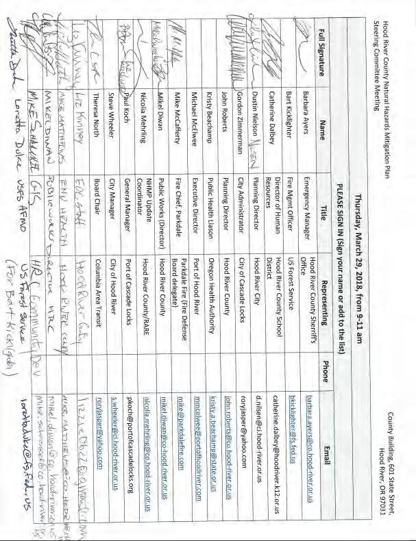
159
160 Meeting #2

161
162 City of Cascade Locks Meeting
163 City of Hood River Meeting

164
165 2012 Plan Update Materials
166 Memo To: Federal Emergency Management Agency From: Oregon Partnership for Disaster Resilience Date: August 31, 2012 Re: List of changes to the 2007 Hood River County NHMP for the 2012 Plan Update Purpose This memo describes the changes made to the 2007 Hood River County Natural Hazards Mitigation Plan (NHMP) during the 2012 plan update process. Major changes are documented by plan section. Project Background In August 2011, Hood River County partnered with the Oregon Partnership for Disaster Resilience (OPDR) to update the 2007 Hood River County Natural Hazards Mitigation Plan (NHMP). The Disaster Mitigation Act of 2000 requires communities to update their mitigation plans every five years to remain eligible for Pre-Disaster Mitigation (PDM) program funding, Flood Mitigation Assistance (FMA) program funding, and Hazard Grant Mitigation Program (HMGP) funding. Members of OPDR and the plan coordinator met with members of the Hood River County steering committee in November (2011), February, May, and June (2012) to update all content within the county s NHMP. OPDR and the committee made several changes to the 2007 NHMP. Major changes are documented and summarized in this memo Plan Update Changes The sections below only discuss major changes made to the 2007 Hood River County NHMP during the 2012 plan update process. Major changes include replacement or deletion of large portions of text, changes to the plan s organization, and new additions to the plan. If a section is not addressed in this memo, then it can be assumed that no significant changes occurred. The plan s format and organization have been altered to fit within OPDR s plan templates. Table B.1 below lists the 2007 plan section names and the corresponding 2012 section names, as updated. This memo will use the 2012 plan update section names to reference any changes, additions, or deletions within the plan.
167 Table B.1: Changes to Plan Sections 2007 Hood River County NHMP 2012 Hood River County NHMP Table of Contents Table of Contents Executive Summary Executive Summary Section I: Introduction Section 1: Introduction Section II: Community Profile Section 2: Risk Assessment Section III: Risk Assessment Summary Section 3: Mission, Goals, and Action Items Section IV: Goals & Action Items Section 4: Plan Implementation and Maintenance Section V: Plan Implementation & Maintenance Hazard Annexes Hazard Annex Appendix A: Action Item Forms Appendix A: Public Process Appendix B: Planning and Public Process Appendix B: Resource Directory Appendix C: Community Profile Appendix C: Household Natural Hazards Appendix D: Economic Analysis Preparedness Survey Appendix D: Economic Analysis Appendix E: Mid-Columbia Region Natural Hazard Mitigation Public Opinion Survey Appendix E: Existing Plans & Programs Appendix F: Grant Programs Appendix F: Mitigation Tools Appendix G: Acronyms Aside from substantial changes to plan section content, the most visible changes to the plan s organization from the update process are the reclassification of the community profile from a section to an appendix, the replacement of the plan s hazard annex with the natural hazard section of Hood River County s Hazard Identification and Vulnerability Analysis (HIVA) document, the addition of an appendix that provides grant program information, and the removal of Appendix G: Acronyms as well as Appendix B: Resource Directory. Front Pages 1. The plan s cover has been updated. 2. Acknowledgements have been updated to include the 2012 project partners and planning participants. Volume I Volume I provides the overall plan framework for the 2012 NHMP update. Volume I contains the following sections: 1) Introduction; 2) Risk Assessment 3) Mission, Goals, and Action Items; and 4) Plan Implementation and Maintenance. Section1: Introduction Section 1 introduces the concept of natural hazards mitigation planning and answers the question Why develop a mitigation plan? Additionally, Section 1 summarizes the 2012 plan update process, and provides an overview of how the plan is organized. Major changes to Section 1 include the following:
168 1. Most of Section 1 includes new information that replaces out of date text found in the 2007 NHMP. The new text defines mitigation, gives examples of mitigation strategies, and describes the federal mitigation funding programs for which Hood River County is eligible to apply (i.e., the Pre-Disaster Mitigation (PDM) Program, the Flood Mitigation Assistance (FMA) Program, and the Hazard Mitigation Grant Program (HMGP)). 2. Section 1 of the 2007 NHMP discussed the methodology for developing a plan and how the plan was organized. OPDR and the plan update coordinator replaced this information with text that summarized the development of the 2007 NHMP and added new text to describe the 2012 plan update process, including plan update meetings, public outreach efforts, and final plan review and adoption processes. Section 2: Risk Assessment Section 2 describes Hood River County s vulnerability to natural hazards in the region. This section highlights the hazards themselves in terms of probability and incidence, and identifies community assets. Major changes to Section 2 include the following: 1. Development of Relative Risk scores to more accurately define hazard risks in the county, and to supplement previously developed Total Threat Scores. 2. An overview of Hood River County hazards was developed that summarizes information from the plan s Hazard Annex. 3. Community Vulnerability has been added to the section, including a listing of community assets and issues that fall under Populations, Economies, Land Use and Development, Critical Infrastructure, and Environment categories. 4. Additional tables address NFIP participation information and general risk assessment scoring. Section 3: Mission, Goals, and Action items This section provides the basis and justification for the mission, goals, and mitigation actions identified in the NHMP. Major changes to Section 3 include the following: 1. Hood River County s steering committee reviewed the 2007 plan s goals and modified them with the goals currently identified in Section 3. One goal (Intergenerational Equity) was deleted from the plan entirely, and four others (Protection of Life and Property, Acknowledge Responsibility, Facilitate Partnerships and Coordination, and Emergency Services Enhancement) were modified slightly in terms of language. The 2007 NHMP goals previously read as follows: Goal #1: Education & Outreach Goal Statement 1: Develop and implement education programs to increase awareness among citizens, local, county, and regional agencies, non-profit organizations, businesses, and industry.
169 Goal Statement 2: Develop and conduct outreach programs to increase the number of local activities implemented by public and private sector organizations. Goal Statement 3: Build community consensus through outreach, education and activities Goal #2: Disaster Resilient Economy Goal Statement 1: Foster a diverse economy to reduce the debilitation impacts of a hazard event on any one sector. Goal Statement 2: Create the conditions for a transitional economy that welcomes new industry and innovative ideas that are sensitive to potential hazard risks faced by the county. Goal Statement 3: Protect recreation and tourist industries by raising awareness of potential hazard impacts. Goal Statement 4: Provide support for agricultural industries to help them prepare for hazardous events. Goal #3: Protection of Life and Property Goal Statement 1: Develop and implement activities to protect human life, commerce, property and natural resource systems. Goal Statement 2: Reduce insurance losses and repetitive claims for chronic hazard events while promoting insurance for catastrophic hazards. Goals Statement 3: Evaluate county guideline/codes, and permitting processes in addressing hazard mitigation; emphasize non-structural means of mitigating hazard impact. Goal Statement 4: When applicable, utilize structural mitigation activities to minimize risks associated with hazard events. Goal #4: Intergenerational Equity Goal Statement 1: Encourage growth and development that meets the needs of the present without compromising future generations. Goal #5: Acknowledge Responsibility Goal Statement 1: Coordinate programs to increase natural hazard knowledge base and use technology to better record events and model vulnerability. Goal Statement 2: Actively acknowledge amount of loss the county is susceptible to and develop efforts to overcome that loss without significant reliance on outside resources. Goal Statement 3: Educate county leadership and incorporate hazard mitigation as part of the county s routine decision making process. Goal #6: Facilitate Partnerships and Coordination Goal Statement 1: Strengthen communication and coordination of public/private partnerships and emergency services among local, county and regional governments and the private sector.
170 Goal Statement 2: Incorporate hazard mitigation into the greater social economic and natural resource goal framework. Goal #7: Natural Resource Systems Protection Goal Statement 1: Link watershed planning, natural resource management, and land use planning with natural hazard mitigation activities to protect vital habitat and water quality. Goal Statement 2: Preserve and rehabilitate natural systems to serve natural hazard mitigation functions and protect recreation and tourist resources. Goal #8: Emergency Services Enhancement Goal Statement 1: Evaluate performance of critical facilities during a natural hazard event. Goal Statement 2: Minimize life safety issues. Goal Statement 3: Ensure resources, staffing and volunteer base keeps pace with county growth. 2. The county s goals were also re-prioritized by members of the 2012 steering committee during a committee meeting activity, where they were re-prioritized to the way they currently appear in Section 3. The goals were previously prioritized as follows: Priority 1: Facilitate Partnerships and Coordination Emergency Services Enhancement Priority 2: Acknowledge Responsibility 3. Several other tables and figures in the section were modified during the plan update. Several new plans were modified and added to Table 3.1: Hood River County Existing Plans and Policies, and several organizations were eliminated or modified in Table 3.2: Hood River County Community Organizations and Programs. Figure 3.2: Hood River County Action Item Framework, a flow chart that outlined the plan s action item framework in terms of coordinating organizations, was also modified to reflect changes and updates to the plan s action items. The Hood River County Action Item Matrix, a set of summary tables describing the county s action items, was also changed to reflect updates to the plan by the steering committee. On May 17, 2012, the Hood River County steering committee met to review the 2007 NHMP action items. The Hood River County steering committee reviewed and identified which of the 2007 NHMP s 51 action items had been completed or not, or whether they should be deleted or deferred. Action items were deleted for a number of reasons, including not meeting basic action item criteria such as being measurable, assignable, or achievable. Action items that were deferred had not yet been addressed or were only partially addressed over the previous five years, but the steering committee decided they were still worthy of being continued through
171 the 2012 update. Most of the Action items that were deferred (36) were modified in some way to make them more achievable, accurate, or actionable. After deciding which actions to defer, the steering committee formulated two new action items for the 2012 Natural Hazard Mitigation Plan. These new action items are based upon continuous community needs, deferred action items, and current needs based upon the community risk assessment. They are designed to be feasibly accomplished within the next five years, and can be found in Appendix A. The 51 action items from the 2007 NHMP and their statuses are discussed in Table B.2 below.
172 Table B.2: 2007 Hood River County NHMP Action Items Action Item Status Comment Description Multi-hazard (ST ongoing) Multi-hazard (ST ongoing) Multi-hazard (ST ongoing) Deferred / Modified Deferred / Modified Deferred / Modified Multi-Hazard (MH) Lack of funding Lack of funding / information is available but no active outreach has been conducted Lack of funding / County Emergency Operations Plan is under review Identification and Pursuit of Implementation Funding for Mitigation Actions and Creation of Part-time Position to Coordinate Efforts (NHMP & CWPP) Develop Public Outreach / Educational Programs Annual Review and Update of the County Community Wildfire Protection Plan, and Natural Hazards Mitigation Plan; Re- Adoption by County Court Every 5- Years; Review and Update of the County Emergency Operations Plan Every 2-Years Multi-hazard (LT ongoing) Multi-hazard (ST ongoing) Multi-hazard (LT ongoing) Multi-hazard (LT) Multi-hazard (LT) Multi-hazard (LT ongoing) Deferred / Modified Deferred / Modified Deferred / Modified Deferred Deleted Deferred / Modified Lack of funding / some updates have been completed (data and information updates) Voluntary registration database is in final stages and nearing completion Lack of funding / ongoing Develop & Maintain Comprehensive Impact Database Create Systems to Support Special Needs Populations Create County Position for Volunteer Coordination & Planning Formation of All Hazard Overhead Lack of priority Team Legislation did not pass at state level, and there is almost Create Emergency Disaster Fund no capacity to create at county level Part of Emergency Operation Plan process Develop Post-Disaster Short Term Recovery Plan Multi-hazard (ST) Completed Finished in 2012 Create Emergency Communication Systems that are Interoperable
173 Action Item Multi-hazard (LT ongoing) Multi-hazard (LT) Multi-hazard (LT) Multi-hazard (LT ongoing) Multi-hazard (LT ongoing) Multi-hazard (LT) Multi-hazard (LT) Drought (LT ongoing) Status Comment Description Deferred Deleted Deferred Deferred / Modified Deferred / Modified Deferred / Modified Deleted Deferred / Modified Lack of priority Superfluous / part of daily business Currently not a high priority Important and ongoing Ongoing County policy is currently under review Not jurisdiction of county Progress is currently being made Develop Small Business Awareness & Continuity Planning Campaign Post-development Inspection Procedures Update County Comprehensive Land Use Plan Improve County Forest Road Maintenance Extend Streamside Vegetation Protection to All Land Uses Identification / Analysis of Irrigation Water Systems & Elimination of Open Irrigation Water with Consideration of Impact on Stormwater Improve U.S. Forest Service Road Maintenance Support Local Agencies Training on Water Conservation Measures and Drought Management Practices Drought (LT ongoing) Deferred / Modified Drought Hazard (DH) Ongoing Ensure Long-range Water Resources Development Flood (ST ongoing) Flood (ST) Flood (ST) Flood (ST) Flood (LT ongoing) Deferred / Modified Deferred / Modified Deleted Deferred / Modified Deleted Flood Hazard (FH) Update completed recently / ongoing Not selected by sponsoring agency (FEMA) No repetitive loss properties/incidence Not selected by sponsoring agency (FEMA) Not applicable to county Mitigate Flood Event Resulting from Naturally Induced Dam Failure Apply for NFIP Community Rating System Address Repetitive Loss Update FIRM Maps Create Flood Identification Inventory
174 Action Item Status Comment Description Flood (LT ongoing) Flood (LT ongoing) Flood (LT ongoing) Earthquake (LT) Earthquake (LT ongoing) Earthquake (LT) Earthquake (LT ongoing) Landslide (LT) Landslide (LT ongoing) Landslide (LT ongoing) Landslide (ST) Landslide (LT) Severe Storm (LT ongoing) Deferred / Modified Deleted Deleted Deferred Deferred / Modified Deleted Deferred / Modified Deferred / Modified Deferred / Modified Deferred / Modified Deleted These concerns are now part of a permitting process / ongoing Completed as part of county's normal operations Lack of priority / lack of funding Earthquake Hazard (EH) Lack of priority by county right now, did not apply for grants New maps are coming out soon Deferred / Modified Deferred / Modified Improve Methods of Barrier Prioritization and Culvert Barrier Remediation for Fish Passage & Flood Mitigation Promote Onsite Stormwater Infiltration and Retention Develop Flood Education and Outreach Programs Rehabilitate Identified Vulnerable Schools, Emergency Facilities, and Public Buildings/Lifelines Improve Knowledge of Earthquake Sources / Improve Earthquake Hazard Zone Maps Improve Understanding of Vulnerability and Risk Covered by previous Action Item No active education / info is available (drills at local Educate Those at Risk schools) / ongoing Landslide Hazard (LH) Not currently a top priority Ongoing No comprehensive maps are currently available Improve Understanding of Landslide Risk Inside Hazard Areas Improve Landslide Hazard Area Maps Provide Education/Awareness for Those at Risk Improve Knowledge of Debris Flow (rapid moving) Landslide Not applicable to county Hazard Areas and Improve Warning Systems Not currently a high county Update County Zoning Ordinance priority Regarding Landslide Hazards Severe Storm Hazard (SH) Have developed partnerships with ODOT, OSP, and other regional entities / ongoing Continue Partnership Programs to Reduce Vulnerability of Public Infrastructure from Severe Winter Storms
175 Action Item Status Comment Description Severe Storm (ST) Severe Storm (ST ongoing) Severe Storm (LT ongoing) Severe Storm (ST) Severe Storm (ST ongoing) Completed Deferred / Modified Deferred Completed Deleted Generators have been acquired for county facilities Part of county zoning code / ongoing Ongoing Plan recently completed Beyond county capacity Encourage Critical Facilities to Secure and Maintain Emergency Power Support/Encourage Electrical Utilities to Use Underground Construction Methods Increase and Maintain Public Awareness of Severe Storms. Enhance Strategies for Debris Management and/or Removal Before/After Storm Event Encourage Building Standards Beyond Minimum State Requirements for Windstorm Impact Severe Created Reduce Trees in Public Utility Wildfire Hazard (WH) Wildfire Deferred Lack of funding Establish County-wide Wildfire Wildfire (ST ongoing) Deferred / Modified Programs have been developed Improve Residential Fire Protection Capacity Wildfire (ST Deferred / ongoing) Modified Ongoing Hazard Fuel Reduction Dependent on priority and Wildfire (ST Deferred / Ensure Proper Road Continuity, funding (is done one piece at a ongoing) Modified Numbering and Naming time) / ongoing Wildfire (ST) Deferred / Modified Currently not a high county priority Update County Zoning Ordinance to Implement the WUI Wildfire (ST ongoing) Deleted Redundant Enhance County GIS Infrastructure Perform Routine Forest Wildfire (ST Management on Zones of Created ongoing) Contribution for County-wide Potable Water Systems Volcano Hazard Volcano (ST) Completed Hazard maps have been acquired for Mt. Hood Acquire or Prepare Detailed Volcanic Hazard Maps
176 Action Item Status Comment Description Volcano (LT) Deferred / Modified County will likely utilize new Mt. Hood maps Improve the Public's Knowledge Base of Volcanic Risk and Vulnerability Volcano (LT ongoing) Deferred / Modified In progress, reverse 911 is being pursued Evaluate Emergency Response Plan and Identify Areas of Public Notification and Evacuation Routes Section 4: Plan Implementation and Maintenance This section details the formal process that will ensure that the Hood River County Natural Hazards Mitigation Plan remains an active and relevant document. Major developments from the Planning Implementation and Maintenance update steering committee meeting involved the following: 1. The committee agreed to maintain its current co-convener structure, in which NHMP duties are split between Hood River County Emergency Management and Hood River County Community Development. 2. The committee agreed to move to an annual, rather than semi-annual, meeting schedule 3. Minor changes and revisions were made to the plan s public involvement strategy. Volume II Hazard Annexes Volume II is comprised of Hood River County s recently updated Hazard Identification and Vulnerability Assessment (HIVA). The document was updated in 2012 by Hood River County Emergency Management, and defines hazards and vulnerabilities in Hood River County and each of its cities. The document contains an introduction that describes risk assessment processes, as well as the methodology used to develop the plan s hazard analysis. The hazard annexes provide detailed risk assessments for drought, earthquake, flood, wildland fire, landslide, severe local storms, tornado, and volcano. The Hazard Annex from the 2007 Hood River County NHMP divided each hazard into four section headings: (1) Best Available Local Data (2) State of Oregon NHMP Mid-Columbia (Region 5) Risk Assessment (3) Hood River County Hazard Identification and Vulnerability Assessment (HIVA) (4) Oregon Technical Resource Guide
177 For all essential purposes of the update process, best available local data was incorporated into the update of the county s HIVA. Information from the Mid-Columbia (Region 5) Risk Assessment was used and referenced during most stages of the 2012 county update process, however references to the Oregon Technical Resource Guide have been removed from the plan. Volume III Resource Appendices Appendix A: Action Item Forms Appendix A is new to the Hood River County NHMP and lists the plan s action items. Action items are detailed recommendations for activities that local departments, citizens and others could engage in to reduce risk. This appendix contains detailed action item forms for each of the mitigation strategies identified in this plan. The 2007 NHMP included action items, but the detailed action item proposal forms were included at the end of the Mitigation Strategy section. The 2012 Appendix A action items include most of the 2007 action items, though most action items were deleted, completed or modified during the 2012 NHMP update process. Appendix B: Planning and Public Process Appendix B includes documentation of all the countywide public processes utilized to develop the plan. It includes invitation lists, agendas, sign-in sheets, and summaries of steering committee meetings, and public involvement meetings or outreach strategies. The 2007 NHMP s public process is also fully documented in Appendix B. Appendix C: Community Profile Appendix C describes the community in a variety of ways. This section highlights geographic, demographic, employment, housing, transportation, and land use characteristics. The community profile was included in the 2007 NHMP as the section II Community Profile. Though the theme of the 2012 community profile is consistent with the Section II Community Profile from the 2007 NHMP, the entire section has been updated and modified in terms of scope and information, expanding from 11 to 50 pages. Appendix D: Economic Analysis of Natural Hazard Mitigation Projects Appendix D describes the Federal Emergency Management Agency s (FEMA) requirements for benefit cost analyses in natural hazards mitigation, as well as various approaches for conducting economic analyses of proposed mitigation activities. This appendix replaces the 2007 NHMP s information about benefit cost analyses. Appendix E: Mid-Columbia Region Natural Hazard Mitigation Public Opinion Survey Appendix E provides a summary report of the survey administered to community stakeholders in the fall of 2011 during the early stages of the Hood River County NHMP Update. The Oregon Partnership for Disaster Resilience (OPDR) distributed a mailed survey to 7,500 random households throughout an eight county region in Northern Oregon. The counties surveyed included: Clackamas, Hood River, Gilliam, Morrow, Sherman, Umatilla, Wasco, and Wheeler.
178 OPDR developed and distributed the survey in partnership with the University of Oregon s Resource Assistance for Rural Environments (RARE) program. This appendix replaces the 2007 NHMP s tables and summaries from the previous regional survey. Appendix F: Grant Programs This appendix lists state and federal resources as well as grant opportunities by agency and program. Appendix F essentially replaces the 2007 NHMP s Appendix B. November 10, 2011 Plan Update Meeting #1 Materials
179
180
181 Memo To: From: Mike Benedict William Clark, RARE-MCCOG / Josh Bruce, OPDR Date: September 2_, 2011 Re: Hood River County Natural Hazard Mitigation Plan Update, Phase I Getting Started Purpose This memorandum outlines the components of Phase I (Getting Started) of the 2011 Hood River County Natural Hazard Mitigation Plan Update, including a preliminary schedule, initial data needs and next steps for the Oregon Partnership for Disaster Resilience (OPDR) as well as the Hood River County Project Lead and Steering Committee. Background A Natural Hazard Mitigation Plan (NHMP) forms the foundation for a community's long-term strategy to reduce disaster losses and break the cycle of disaster impacts, reconstruction and repeated damage. It creates a framework for risk-based decision making to reduce damages to lives, property and the economy from future disasters. Jurisdictions with Federal Emergency Management Agency (FEMA) approved mitigation plans are eligible for federal grant funding to implement those mitigation items identified in the plan. Jurisdictions are required to review, update, and re-seek FEMA approval of their plans every five years in order to maintain grant eligibility. Hood River County adopted its Natural Hazard Mitigation Plan in January 2007 making it due for its 5-year update early The NHMPs of Clackamas, Wasco, Sherman, Gilliam, Morrow, Wheeler and Umatilla Counties are also nearing expiration. In an effort to streamline the update process, OPDR will facilitate a regional planning approach with training sessions, technical assistance and plan updates occurring for each county simultaneously. We anticipate holding up to four regional training sessions, and appreciate your cooperation as we attempt to facilitate this process as efficiently as possible.
182 Preliminary Fall and Winter Schedule Between now and January 2012, OPDR will work with Hood River County Emergency Management to: Develop a Work Plan (October 2011) Establish a viable work plan with the intention of submitting the Hood River County NHMP Update for FEMA approval in the summer of 2012 Review the OPDR Plan Update Training Manual (available on Basecamp) Conduct Project Initiation Meeting Between OPDR and County Project Leads (October 2011) Review scope of work and overall project schedule Review roles and responsibilities Coordinate plan update training schedule and locations In order to maintain momentum and complete the plan update on schedule OPDR suggests that Hood River County complete the following during this same period: Reconvene Mitigation Plan Steering Committee (October 2011) Convene 2007 Hood River County NHMP Steering Committee* Identify and invite new participants or jurisdictions External Partners (e.g. Oregon Department of Forestry, National Forrest Service, Oregon Department of Agriculture, school districts, U.S. Army Corps of Engineers, Hospitals, Soil and Water Conservation Districts, etc.) Incorporated Jurisdictions (e.g. Hood River, Cascade Locks) Develop a Public Involvement Strategy (October/November 2011) Review and update strategy identified in the 2007 Hood River County NHMP Outreach strategies may include stakeholder surveys, public information workshops, and press releases Collect Data (November/December 2011) Collect mitigation plan maintenance meeting agendas and minutes from the previous five years Collect documentation related to any hazard occurrences or emergency declarations in Hood River County since 2007
183 Identify and document plan implementation activities, including completed projects and other success stories Collect any local, state, or federal studies or reports completed since 2007 Local development ordinances, flood maps, HAZUS studies, DOGAMI studies, USGS reports, etc. Identify necessary updates to the 2007 Hood River County NHMP (November/December 2011) Mitigation Item Analysis (completed, pending, and un-initiated) Previously identified data limitations Next Steps for OPDR Grant Administration Finalize specific scope of work for Hood River County Project Initiation Schedule and hold kickoff meeting with regional project leads Next Steps for Hood River County Convene NHMP Steering Committee Provide county assessment and taxation data Brief county administration on project Notify public?? PSA we can help write it and get it to local news outlets Identify potential stakeholder groups Should you have any questions or concerns, please do not hesitate to contact Will Clark at (541) x206 or via at or Josh Bruce at (541) or via at * Previous Steering Committee Members include: Anne Debbaut, Hood River County Planning Jennifer Donnelly, City of Hood River Planning Peter Mackwell, West Side Fire District Jeff Pricher, City of Cascade Locks Anne Saxby, Soil and Water Conservation District
184 Hannah Settje, American Red Cross Jade Soddell, Emergency Management Joe Wampler, Sheriff s Department Don Wiley, Hood River County Public Works
185 February 15, 2012 Plan Update Meeting # 2 Materials
186
187
188 May 17, 2012 Plan Update Meeting # 3 Materials
189
190
191 June 28, 2012 Plan Update Meeting # 4 Materials
192
193
194 NHMP Press/Public Outreach Documentation

195
196 2007 Plan Development Public Process People tend to support what they help build. To engage public support of this plan, and to involve the residents in the process, the University of Oregon RARE participant assigned to coordinate this projected reached out to the Hood River County community in three primary ways. First, a steering committee was formed to guide the NHMP Coordinator through the process of developing the plan. Secondly, The Coordinator sent out invitations to key stakeholders and an open invitation to the public for a NHMP Community Stakeholder Forum to raise awareness about natural hazard events and solicit input from community. Lastly, stakeholder interviews were conducted to retrieve local community knowledge of hazard events and how to best address the community s risk. Secondary methods of outreach were also conducted in posting the final draft of the mitigation plan for public comment on the County Planning & Development website and the printing and distribution of the International Business & Home Safety Protect Your Home From Wildfire brochure at the Hood River County Planning & Building services counter. Lastly, ONHW conducted region-wide outreach and training efforts in the form of a regional household preparedness survey and IBHS Open for Business training. Steering Committee The Hood River County Steering Committee was comprised of individuals best suited to guide the county through the planning process and ensure that the mitigation plan is fully implemented once adopted. Its mission is to ensure proper development and implementation of the county natural hazards mitigation plan by: setting goals; establishing subcommittee work groups to address specific needs; ensuring public, private and federal participation; distributing and presenting the plan; facilitating public discussion/involvement; developing implementation activities; and coordinating plan maintenance and implementation strategies. Through raising awareness and citizen involvement, the Committee s end goal is to make hazard mitigation a part of the community s routine decision-making process.

197 Methodology Three Steering Committee sessions were held over the course of the 2006 calendar year: 1) Introduction & Overview: 18 January ) Hazard Risk Assessment: 3 March ) Goals & Action Items: 14 July 2006 These sessions set the tone and structure for the plan s development. Through these meetings the NHMP Coordinator was able to collect valuable information regarding hazard events and impacts within the County, as well as contacts for additional stakeholders to involve in the process. The Steering Committee also played an integral part in the development of the mitigation plan vision, mission, goals and action items. The Committee revised the drafted vision, mission and goals, and selected and prioritized the action items documented in this plan. Participants The steering committee was formed by Michael Pasternak, NHMP Coordinator under the guidance of Mike Benedict, Hood River County Planning & Building Services. Additional input provided by the Oregon Natural Hazards Workgroup. Participants included: Community Stakeholder Forum The County-wide Stakeholder Forum held was designed to solicit input from individuals and community organizations with resources or property that may be severely impacted by natural disasters. The Forums was held on April 11th 2006 at the County Business & Administration Building in Hood River, OR. Roughly 50 people from the County were invited to attend the Forum. The invitees consisted of business leaders, utility providers, government workers (state and county), service providers, transportation & communication
198 workers, health providers, and representatives of vulnerable populations (e.g. elderly, migrant workers). The purpose of the Forum was three-fold: 1) To spread awareness of potential disasters impacting the County by soliciting a large cross-section of the active public to participate in the hazard mitigation process; 2) To provide a factual basis for potential hazard mitigation measures by public input into critical County infrastructure and resources, and known hazard zones, through the critical asset and hazard identification mapping exercise; and 3) To plant the seeds for potential mitigation measures by introduction and discussion of the action item concept and creating personal relationships (i.e. face-toface introduction) for stakeholder interview and action item follow-ups. Those that participated in the Forum were actively responsive to the mapping exercise and the concepts and importance of hazard mitigation. The identification of critical assets and infrastructure re-enforced much of what had already been identified in steering committee meetings and coordinator research, and also provided some previously overlooked assets. All Forum participants have been willing participants in the stakeholder interview followups. Methodology & Outcomes The method and outcomes of the Community Stakeholder Forum are described below: (1) DOGAMI Hazard Impact Overview Bill Burns, DOGAMI Engineering Geologist presented and dissected local and state natural hazards data, and informed participants on how communities are impacted by natural hazard events. Outcome: Documented community stakeholder knowledge/input with respect to local hazard events. (2) Community Asset Identification Exercise Participants were asked to fill out a worksheet identifying the County s critical infrastructure and assets. Outcome: (a) Identified and discussed key elements of the region and individual communities within it; and (b) Identified main assets, resources and functions of region within the themes of People, Dollars (economy, cultural & historic assets, environmental assets), and Infrastructure (critical physical facilities).

199 Participants identified many of the same critical assets identified in the Steering Committee meeting and NHMP Coordinator research. This that assured that data collected for mitigation plan purposes was relevant. (3) Community Mapping Exercise Participants were asked to map assets & infrastructure from previous exercise Outcome: (a) Discussed and documented implications with regards to asset loss/damage to community; (b) Provided mechanism to focus planning efforts; (c) Provided a fact base for subsequent action item identification, and (d) Provided physical document (map) of community input. (4) Action Items & Follow-up Stakeholder Interviews Discussed importance mitigation and the development of action items; passed out action item forms to participants Outcome: Documented potential action items discussed in forum, and distributed action item worksheets to participants. Set up stakeholder interview. Invitees The following the individuals and organizations were contacted to participate in the Forum:

200 Stakeholder Interviews Due to poor community participation in the Stakeholder Forum, the stakeholder interviews became a crucial component of the public process. Many of the Forum invitees were contacted and their input included in the plan. The individuals contacted ranged from city,
201 state, and federal government employees to business owners and farmers. These individuals provided insight into how hazard events have impacted the community in the past, how growth and development could collide with future hazard events, and how the community can best work together to reduce collective risk. Many of the action items documented in this plan were spawned from ideas discussed during the stakeholder interview process. Methodology Stakeholder interviews were conducted May through July The NHMP Coordinator telephoned stakeholders individually and asked a series of questions. The questions are as follows: What is the history of natural hazard events in Hood River County? How does growth and development in the community, both current and projected, contribute to natural hazard events? Does your organization/industry currently work in natural hazard mitigation? If so, how? How can your organization/industry contribute to strengthen regional coordination and cooperation in reducing risk from natural hazards? What activities will assist Hood River County in reducing risk and preventing loss from future natural hazard events? (e.g. If you had the money, how would you spend it?) How does your organization/industry view the County government s role in reducing risk from natural hazard events? What are the ways you would like to see agencies, organizations or individuals participating and coordinating to reduce risk from natural hazard events? How does hazard mitigation fit into Hood River County s land-use, environmental, social, and economic goals? What goals should the County set to reduce risk from natural hazard events, and how would we measure whether our mitigation efforts are successful? Can you think of anyone else that should be contacted as part of this process? The information recorded from the stakeholder interviews was primarily incorporated into three sections of this plan: Community Profile, Risk Assessment, and Goals & Action items. Contacts The following the individuals and organizations were contacted to participate in the stakeholder interview process:

202 Secondary Outreach Methods Additional methods of outreach involved in the public process included: Public Comment of Hood River County NHMP Draft The mitigation plan draft was sent to steering committee members for review, comment, and approval before the final draft was shipped off the OEM for State review. Additionally, the plan was posted on the Hood River County Planning & Development website for public review and comment. IBHS Wildfire Brochure While the final draft of the NHMP was under review by the Steering Committee and public, the NHMP Coordinator oversaw the printing and distribution of the International Business & Home Safety Protect Your Home From Wildfire brochure at the Hood River County Planning & Building service counter. ONHW Region-wide Outreach
203 The Oregon Natural Hazards Workgroup conducted region-wide outreach activities which included: Household Preparedness Survey As part of the regional PDM grant, ONHW implemented a region wide household preparedness survey. The survey gauged household knowledge of mitigation tools and techniques and assessed household disaster preparedness. The survey results improve public/private coordination of mitigation and preparedness for natural hazards by obtaining more accurate information on household understanding and needs. The results of the survey are documented in the plan s Appendix C: Regional Household Survey. IBHS Open for Business Training ONHW, with commitment from the Institute for Business & Home Safety (IBHS), provided individuals in the Mid-Columbia region with access to, and use of, the IBHS interactive, webbased Open for Business property protection and disaster recovery planning tool. The access was provided in two classes, one located in Hermiston, Oregon on May 24th, 2006 and the second in The Dalles, Oregon on May 25th, The following agencies and organizations were invited to attend: agencies providing start-up and ongoing counseling services to micro and small businesses in low-income areas, such as the Statewide Small Business Development Center; agencies providing housing services to hundreds of lowincome residents, such as County Housing Authorities, which also employs low-income people; and disaster assistance agencies serving at-risk populations, such as food banks and the American Red Cross. Any remaining spaces were made available to: micro- or small business start-up companies; and established micro- or small businesses. The classes were organized as train-the-trainer classes, so that the agency personnel and the business people could: 1. Understand the importance of disaster planning; 2. Learn how to navigate the interactive, web-based Open for Business property protection and disaster recovery planning tool; 3. Start to develop their own plans during the training; 4. Learn how to communicate the importance of developing and utilizing plans for property protection and recovery from business interruption to their constituencies and/or colleagues, in order to institutionalize disaster safety into every day decision making. Recruitment Process The Oregon Natural Hazards Workgroup assembled a list of social service providers from basic internet searches and representative small businesses from Chamber of Commerce Membership databases for the seven counties in the region. and/or mailed invitations were sent to over 200 agencies, organizations and businesses in the region. Recruitment materials can be found on the following page. The following agencies and organizations attended the workshop: Umatilla/Morrow County Housing Authority Irrigon Chamber of Commerce
204 Pendleton Chamber of Commerce Small Business Development Center Blue Mountain Community College Small Business Development Center Columbia Gorge Community College
205 This page left intentionally blank.
206 Appendix C: Community Profile The following section describes Hood River County from a number of perspectives to help define and understand its sensitivity and resilience to natural hazards. Sensitivity and resilience indicators are identified through the examination natural environment, sociodemographic capacity, regional economy, physical infrastructure, community connectivity and political capital This section provides a useful framework for identifying the diverse resources and activities that make up Hood River County. 70 Sensitivity factors can be defined as community assets and characteristics that may be impacted by natural hazards. Community resilience factors can be defined as the community s ability to manage risk and adapt to hazard impacts by way of the governmental structure, agency missions and directives, as well as through plans, policies, and programs. This section describes both sensitivity and resilience factors to outline resources Hood River County might use to mitigate natural hazards. Contents Appendix C: Community Profile...clxxxvi Natural Environment Capacity... cxc Geography... cxc Rivers... cxci Climate... cxciii Hazard Severity... Error! Bookmark not defined. Synthesis... cxciv Socio Demographic Capacity... cxciv Population... cxciv Age... cxcvi 70 Cornelia Flora, Jan Flora, Susan Fey and Mary Emery, Community Capitals Framework, English Language Learners Symposium.
207 Race... cxcix Education... cc Income... cci Language... Error! Bookmark not defined. Health and Safety... cciii Vulnerable Populations... cciv Tourists... ccv Synthesis... ccvi Regional Economic Capacity... ccvi Regional Affordability... ccvi Economic Diversity... ccvii Employment and Wages... ccviii Industry... ccxi Labor and Commute Shed... ccxv Synthesis... ccxviii Built Capacity... ccxviii Housing Building Stock... ccxviii Physical Infrastructure... ccxx Utility Lifelines... ccxxv Power Generation... ccxxv Petroleum and Natural Gas Service... ccxxvi Telecommunications... ccxxvii Sewage and Landfill... ccxxviii Drinking Water...ccxxix Critical Facilities...ccxxix Dependent Facilities... ccxxxv Correctional Facilities... ccxxxv Synthesis... ccxxxvi Community Connectivity Capacity... ccxxxvi Social Organizations... ccxxxvi Civic Engagement... Error! Bookmark not defined. Cultural and Historic Resources... ccxxxvii Historic Places... ccxxxvii Libraries and Museums... ccxxxvii Community Stability... ccxxxviii
208 Synthesis... ccxxxviii Political Capital... ccxxxix Government Structure... ccxxxix Existing Plan & Policies... ccxliii Mutual Aid Agreements... ccxlv Synthesis... ccxlvi

209 The information in this section represents a snapshot in time of the sensitivity and resilience factors in Hood River County during the plan s most recent update. The information documented below, along with the hazard assessments located in Section 2: Risk Assessment, should be used as the local level rationale for the risk reduction action items identified in Appendix A. The U.S. Census delineates areas of settled population concentrations that are identifiable by name but are not legally incorporated as Census Designated Places (CDPs). There are three CDPs in Hood River County: Mount Hood, Odell, and Parkdale. There are two incorporated cities in Hood River County: Cascade Locks and the City of Hood River. The remainder of this appendix will provide information for the unincorporated communities and County. Detailed information for each incorporated city participating in this NHMP is provided within each city s addendum (Volume II). Data applying to Census Designated Places may contain inaccuracies due to small sample size. They have been noted or adjusted when possible. Figure C.1: Hood River County Incorporated Cities and Census Designated Places Source: Community Service Center, University of Oregon
210 Natural Environment Capacity Natural environment capacity is recognized as the geography, climate, and land cover of the area such as, urban, water and forested lands that maintain clean water, air and a stable climate. 71 Natural resources such as wetlands and forested hill slopes play significant roles in protecting communities and the environment from weather-related hazards, such as flooding and landslides. However, natural systems are often impacted or depleted by human activities adversely affecting community resilience. Geography Hood River County, located in the north central section of Oregon in the Columbia Gorge, has a land area of 533 square miles, making it the second smallest county in the state in terms of geographic area. Its dimensions are a length of 32 miles from north to south, and a width varying from 23 miles, in the north, to 10.5 miles in the extreme south. It is situated on the eastern edge of Oregon s Cascade Range and west of the Umatilla Plateau, bounded by Mt Hood and the Mt Hood National Forest to the south, and the Columbia River to the north. The majestic snowcapped Mt. Hood in the southwest portion of the county, and the Columbia River Gorge to the north, provide the stunning backdrop that has made Hood River one of the most unique and beautiful places in the Northwest. The County is characterized by extreme weather, diverse terrain, and multiple recurring natural hazards. The northern boundary of the Columbia River also marks the boundary between Oregon and Washington. Oregon, like most of the Western States, is largely owned by the federal government with a vast majority of federal lands administered by the Bureau of Land Management (BLM) and the United States Forest Service (USFS). 72 In Hood River County 27% of the land is privately owned (roughly 90,000 acres), whereas the remaining 73% is held publicly. The majority, 62% is owned by the US Forest Service (roughly 208,000 acres). 73 Land owned by the US Forest Service arcs from the west of Hood River County to the southeast, and is primarily designated as the Mt Hood National Forest. A majority of the private land in the county is either agricultural land or forest, and the entire county is classified as rural except for land within the City of Hood River. 74 Table C.1: Hood River County Land Ownership Ownership Square Miles Acreage Percentage Federal (Primarily USFS) ,811 62% County Owned ,213 9% State 6.7 4,274 1% City % Special Districts (Ports, Irrigation, Parks) % 71 Mayunga, J Understanding and Applying the Concept of Community Disaster Resilience: A capital-based approach. Summer Academy for Social Vulnerability and Resilience Building. 72 Allan, Stuart et al., Atlas of Oregon. Pg Allan, Stuart et. al., Atlas of Oregon. Pg U.S. Census Bureau, 2010 Census, Oregon s 68 Urban Areas
211 Other non-assessed (Church, School, or Cemetery property) % Total Non-Private , % Private , % Total , % Source: Hood River County Community Development, 2015 Hood River County is a relatively compact physiographic unit, primarily situated in the Middle Columbia Basin. The Hood River Valley, occupying the bottom of the Hood River drainage basin, is 20 miles long and four to eight miles wide. Local relief separates the valley into two distinct units known as the Lower and Upper Valleys. The Lower Valley, the larger unit, extends about six miles southward from the Columbia River to Middle Mountain, a traverse ridge about 2,000 feet in elevation. A low ridge encloses a small bench of a few thousand acres on the north flank of Middle Mountain known locally as Middle Valley. The Upper Valley, located south of Middle Mountain, is approximately seven miles long and four miles wide and rises southward in elevation from 1,500 to 3,000 feet. Depictions of the Hood River Watershed land-cover and water systems can be found in the Hood River Soil and Water Conservation District Action Plan and associated maps. 75 The surface of the entire valley was modified by glacial action. A till sheet of varying thickness was laid down over the floor and subsequently reworked by glacial melt waters and forerunners of the present rivers. The soil pattern is directly related to the nature of the local till and the action of water. Variations range from silt loam laid down in the quiet waters of a lake in the bottom lands of the Lower Valley, to loams derived from weathering of glacial outwash materials and gravelly sandy loams derived from stream deposits. In portions of the Upper Valley, soils deriving from recent volcanic ash deposits cover many outwash terraces. Rivers Most of Hood River County is within the drainage basin of the Hood River. The Hood River system rises on the slopes of Mt. Hood and flows north to join the Columbia River at the City of Hood River, a river distance of 39 miles and a fall of 7,500 feet from source to mouth. COLUMBIA RIVER BASIN The Columbia River Basin is North America's fourth largest, draining a 259,000 square mile basin that includes territory in seven states (Oregon, Washington, Idaho, Montana, Nevada, Wyoming and Utah) and one Canadian province (British Columbia). The river flows for more than 1,200 miles, from the base of the Canadian Rockies in southeastern British Columbia to the Pacific Ocean at Astoria, Oregon, and Ilwaco, Washington. The Columbia is a snow-charged river that seasonally fluctuates in volume. Its annual average discharge is 160 million acre-feet of water with the highest volumes between April and September and the lowest from December to February. From its source 75 Hood River Watershed Action Plan, 2002; Hood River Watershed Group; file:///z:/natural%20hazards%20mitigation%20plan/2018%20hood%20river%20 Update/ActionPlan%20Soil%20and%20water%20consevation%20district.pdf; file:///z:/natural%20hazards%20mitigation%20plan/2018%20hood%20river%20update/appendix_ A_3%20Soil%20and%20water%20conservation%20district%20maps.pdf
212 at 2,650 feet above sea level, the river drops an average of more than two feet per mile, but in some sections it falls nearly five feet per mile. 76 The Columbia River is a complex waterway which includes regular activity of barges, windsurfers, boaters, strong currents, and windy conditions as it passes by Hood River County. It flows directly alongside major transportation corridor I-84 and a major east-west railway (Union Pacific). The Columbia River Basin is the most hydroelectrically developed river system in the world. 77 There are more than 250 reservoirs and around 150 hydroelectric projects in the basin, including 18 mainstream dams on the Columbia and its main tributary, the Snake River. The US Army Corps of Engineers (COE) and the Bureau of Reclamation (USBR) are the owners and operators of the 31 federally owned hydro projects on the Columbia and Snake Rivers. Bonneville Power Administration markets and distributes the power generated from these federal dams and from Columbia Generating Station. BPA also owns and operates about 75% of the Northwest's transmission system. The dams and the electrical system are known as the Federal Columbia River Power System (FCRPS). The Federal Columbia River Power System (FCRPS) is a unique collaboration among three U.S. government agencies the Bonneville Power Administration (BPA), the U.S. Army Corps of Engineers (the Corps) and the Bureau of Reclamation (Reclamation). Collectively, these agencies generate power, protect fish and wildlife, control floods, provide irrigation and navigation, and sustain cultural resources. HOOD RIVER The Hood River drains 339 square miles (217,340 acres) of Hood River County and consists of three main forks (West, Middle, and East) that converge into the mainstem Hood River near River Mile 12.0 (along the Dee Highway, by Dead Point Creek Falls). The drainage contains approximately 400 miles of perennial stream channel of which an estimated 100 miles is accessible to anadromous fish. The Hood River Watershed has been fully evaluated and described in the Hood River Watershed Assessment. 78 Five tributaries of the three forks are fed by glacial sources that drain approximately one third of the total glacial ice on Mt. Hood. During high flows, large amounts of bedload and sediment are transported in these tributaries and in the mainstem. Glacial melt increases water turbidity in the form of suspended silt and glacial flour during summer and early fall. Glacial sediment is more prevalent in the Middle and East Forks and Hood River mainstem, while glacial sediment in the West Fork is contributed by a single small tributary, Ladd Creek. Natural disturbances that contribute significant amounts of sediment to stream channels include landslides and debris torrents that originate on glacial moraines and steep slopes of Mt Hood. Typical of many Cascade mountain streams, the hydrology of Hood River County is characterized by highly variable stream flow and rapid storm runoff. The mean annual flow for water year 2016 in the 76 Center for Columbia River History. Columbia River. Written by: Bill Lang Professor of History Portland State University, Former Director, Center for Columbia River History Ibid 78 Hood River Watershed Assessment, 1999, Hood River Soil and Water Conservation District; file:///z:/natural%20hazards%20mitigation%20plan/2018%20hood%20river%20update/watershed %20Councils_300_DOC_HoodR_WSassess_1999.pdf

213 Hood River is 1,063 cubic feet per second (cfs) at Tucker Bridge (River Mile 6.1). Mean monthly flows in water year 2016 range from 274 cfs in August to a high of 1,895 cfs in March. Snowmelt generally begins during April. Many tributaries have very low summer flows, while tributaries with glacial sources maintain higher flows. Natural disturbances occurring in the Hood River watershed include floods, fires, mudflows, landslides, and insect and botanical disease epidemics. Rain-on-snow floods are common disturbance events. Periodically, natural dams created by terminal moraines at receding glaciers on Mt. Hood break and cause floods and debris flows; many of these events are triggered by intense rainstorms. Landslides are common but not frequent events. Figure C.2: Land Ownership in the Hood River Watershed Climate Source: Natural Resources Consulting, Inc, Provided by Hood River County. TEMPERATURE, PRECIPITATION AND TOPOGRAPHY The Hood River Valley lies in a transitional zone between the marine-influenced climates west of the Cascade Mountains and the dry-continental climate of the intermountain region. Local topography and elevation create marked differences in average temperature and precipitation between the Lower and Upper Valleys, and between the eastern and western portions of the County. The Columbia Gorge is a near sea-level water gap through which marine, often relatively warm, air normally flows from the west.
214 The county s rolling topography creates local differences in wind patterns, and highly unstable climatic conditions are found in the Columbia Gorge and nearby areas as a result. The contact between continental and maritime air masses produces strong wind patterns. Prevailing winds are north-westerly in summer and north-easterly in winter, but are highly variable throughout the Gorge. Winds are less dominant away from the Columbia Gorge, and southern parts of Hood River County are generally protected from winds by the Cascade Mountains. Reliable mile per hour winds throughout summer, and occasional extreme gusts, draw many wind sport recreationalists. Strong marine influences also reflect the occurrence of precipitation, more than half of which falls from November through February. The city has an average growing season of 183 days. The County is temperate in climate, with summer temperatures ranging from degrees and winter temperate ranging from degrees. In this period of record, the average annual precipitation equaled 30.6 inches per year; however precipitation varies significantly throughout the County. The City of Cascade Locks receives more than twice the rainfall than the City of Hood River. Snowfall amounts averaged 36.0 inches per year with the highest amounts occurring in December and January. Note that snowfall averages displayed in the table below are from over a hundred years of observation, and thus may not be representative of current climate trends. 79 Like rain, snowfall varies significantly throughout the County, from over a hundred inches at Mt. Hood to zero or near zero by the Columbia River. Synthesis Natural capital is essential in sustaining all forms of life, including human life, and plays an often under represented role in natural hazard community resiliency planning. With four distinct mild seasons, a diverse terrain and its proximity to the Columbia Gorge, Hood River County has historically dealt with habitual severe storms and wildfires, drought, flooding, and recurring landslides. Managing natural capitals with hazards in mind can increase Hood River County resiliency. Socio Demographic Capacity Social/demographic capacity is a significant indicator of community hazard resilience. The characteristics and qualities of the community population such as language, race and ethnicity, age, income, educational attainment, and health are factors that influence the community s ability to cope with, adapt to and recover from natural disasters. Population According to the Portland State Population Research Center, the population of Hood River County was 24,735 on July 1, 2016 an increase from the 2010 population of 22, The population in the State of Oregon increased by 9.4% from 2010 to 2016, while the population of Hood River County increased by 10.7%. 81 The county is primarily rural and currently the twenty-third most populated in the State of Oregon. The population of the county is slightly less than neighboring Wasco County which is to the east, and significantly 79 National Centers for Environmental Information; Normals; 80 Oregon Annual Population Report 2016; PSU Population Research Center; April 2017; 81 Ibid.
215 less than the populations of neighboring Clackamas and Multnomah Counties, which are to the west. Table C.1 describes the population change in Hood River County and nearby communities. Table C.1: Regional Change in County Populations 2010 Census Population 2016 Population Estimate Percent Change Average Annual Change Net Migration HOOD RIVER 22,346 24,735 2, % 1.6% 691 1,698 CLACKAMAS 375, ,980 28, % 1.2% 5,243 23,745 GILLIAM 1,871 1, % 0.9% MULTNOMAH 735, ,670 55, % 1.2% 24,434 30,902 SHERMAN 1,765 1, % 0.3% WASCO 25,213 26,700 1, % 0.9% -50 1,537 OREGON 3,831,074 4,076, , % 1.0% 73, ,874 Source: U.S. Census Bureau, 2010 Census; Oregon Annual Population Report 2016 prepared by PSU Population Research Center, dated April 2017 The largest populated area in Hood River County is the City of Hood River, where just under a third of county residents reside. Table C.2 describes the population change between 2010 and 2016 in the Cities of Hood River and Cascade Locks, along with the unincorporated areas of Hood River County, compared to the county as a whole. The unincorporated areas of Hood River County had the highest percent increase in population. These areas include the Census Designated Places (CDPs) of Odell, Parkdale, and Mt. Hood. Note that many of the small jurisdictions and unincorporated areas have limited resources with respect to fire, police and emergency medical. In most cases, the residential populations are served by volunteer fire fighters and emergency medical technicians. In areas with a positive population growth, it will be important to continue to promote volunteer service that will be responsible as first responders in the event of a natural hazard. See Political Capital: Education and Outreach for a description of recent increases in volunteer programs. Table C.2: Change in Hood River County Population Jurisdiction Population (2010) Population (2016) Population Change ( ) Percent Change ( ) Average Annual Growth Rate Hood River 7,180 7, % 1.3% Cascade Locks 1,145 1, % 1.5% Unincorporated 14,060 15,725 1, % 2.0% Hood River County 22,385 24,735 2, % 1.7% Source: U.S. Census Bureau, 2010 Census, 2016 estimates from Oregon Annual Population Report 2016 prepared by PSU Population Research Center, dated April 2017
216 These population counts provide a snapshot of growth. Population tracking methodology also provides population projections to support planning and development. The Hood River County population is expected to continue to increase over the coming decades, especially in the City of Hood River. Table C.3: Population Forecast for Hood River County Area/Year % Growth ( ) Hood River County 29,014 32,045 34,939 30% Cascade Locks UGB 1,408 1,515 1,605 21% Hood River UGB 11,811 13,342 14,804 72% Outside UGB Area 15,795 17,188 18, % Source: Population Research Center, Portland State University, June 30, The Columbia Gorge area is the fastest-growing rural region in Oregon, with growth projected at 11 percent between 2014 and Growth will add about 3,300 job openings, while 7,300 replacement openings are projected. Leisure and hospitality expects the most replacement openings, swiftly followed by education and health services, and natural resources each accounts for about 1,200 openings by (Source?)However, it is likely that many jobs will be low paying or part time, so incomes may not keep pace with rising living costs. The location, composition and capacity of the population within the community determines vulnerability. Factors such as age, race, education, income, health and safety can impact a community s resilience to and ability to recover from, natural disasters. It is important to recognize that women tend to have more institutionalized obstacles than men during recovery due to sector-specific employment, lower wages, and family care responsibilities (Cutter et al., 2003). Age The age profile of an area impacts both what actions are prioritized for mitigation and how response to hazard incidents is carried out. Figure C.3 illustrates the current and projected percentage of population by age groups within the county.
217 Figure C.3: Hood River County Population by Age, 2016 and % 29% 30% 30% 27% 25% 25% 24% 23% 21% 21% 20% 15% 10% (projected) 5% 0% Under 20 Ages Ages Ages 60+ Source: Hood River County Final Forecast Tables; Population Research Center, Portland State University, June 30, Figure C.3 illustrates the percentage of population by various age groups in the cities and incorporated areas compared with Hood River County as a whole. The CDPs have a much higher population of children than the County or State averages, while the City of Cascade Locks has a higher elderly population. Special consideration should be given to young children, schools, and parents during the natural hazard mitigation process. Young children are more vulnerable to heat and cold, have fewer transportation options, and require assistance to access medical facilities. Parents may lose time from work and money when their children s childcare facilities and schools are impacted by disasters (Cutter et al., 2003). Older populations may require assistance in an evacuation due to limited mobility or health issues. Additionally, older populations may require special medical equipment or medications and can lack the social and economic resources needed for post-disaster recovery Wood, Nathan. Variations in City Exposure and Sensitivity to Tsunami Hazards in Oregon. U.S. Geological Survey, Reston, VA, 2007.
218 Figure C.4: Hood River County Population Distribution by Age, % 60% 50% 40% 30% 20% 10% 0% Hood River County Population Distribution by Age City of Hood River City of Cascade Locks Mount Hood CDP Odell CDP Parkdale CDP Source: Social Explorer Table T7; ACS 2016 (5-Year Estimates); U.S. Census Bureau Oregon Age 0-17 Percentage Age Percentage Age 65+ Percentage Other high risk populations include the number of households where persons over the age of 65 live alone as well as single parent households with children under 18. Table C.4 describes the high risk populations in each jurisdiction within the county. Over 30% of the households in the county have individuals living in them who are 65 or older, and close to half of those (13%) are 65 or older householders that live alone. Additionally, 8% of the households in the county are occupied by single parents with children under the age of 18. These groups are more heavily impacted because they may lack the necessary resources, knowledge, skills, social support structures, or the mental and physical abilities necessary to take care of themselves. Historically, vulnerable populations present a special challenge to emergency managers and response agencies and they are more likely to be victims of a disaster Source: Hood River County HIVA, July 2008
219 Race Table C.4: Hood River County High Risk Populations Source: Social Explorer Tables T165 and T17; ACS 2016 (5-Year Estimates); U.S. Census Bureau Race Total Population: White Alone High Risk Households The impact following a disaster in terms of losses and the ability of the community to recover may also vary among minority population groups. Minorities are more likely to be isolated in their communities, are less likely to have the savings to rebuild after a disaster, and less likely to have access to transportation and medical care. 89% of Hood River County residents identify as white, however, 40% of the population identifies as Hispanic (see next section). The majority of residents who identify as some other race than white live in CDPs and unincorporated areas of the County. Table C.5 depicts where the Hood River County Hispanic population resides. Hood Cascade Hood Mount Odell Parkdale River Locks River City Hood CDP CDP CDP County 22,842 1,134 7, , , % 1, % 6,74 7 9% 218 Black or African American Alone % 0 0.0% % 0 0.0% % 0 0.0% American Indian and Alaska Native Alone % % % 0 0.0% % 0 0.0% Asian Alone % 0 0.0% % 0 0.0% 0 0.0% % Native Hawaiian and Other Pacific Islander Alone Some Other Race Alone 1, % 2, % 7 0.0% 0 0.0% 0 0.0% 0 0.0% 7 0.3% 0 0.0% % 5.1% 0 0.0% % % % 0 0.0% Two or More Races % % % 0 0.0% % 0 0.0% Source: Social Explorer Tables T13; ACS 2016 (5-Year Estimates); U.S. Census Bureau Table C.5: Hood River County Hispanic Ethnicity Hood River County Hood River County Cascade Locks City Percent Cascade Locks Percent Hood River City Mount Hood CDP The City of Hood River Total households 8, ,972 Households with individuals under 18 Single householder with own children under 18 Households with individuals 65 years and over Householder 65 years and over living alone Odell CDP Total Population 22,842 1,134 7, , Percent 2, % % 1, % % % % 2, % % % % % % Parkdale CDP Not Hispanic or 15,796 69% 1,110 98% 5,580 75% 84 35% % %
220 Latino Hispanic or Latino 7,046 40% 24 2% 1,896 25% % 1,683 68% % Source: Social Explorer Table T14; ACS 2016 (5-Year Estimates) (SE), ACS 2016 (5-Year Estimates), Social Explorer; U.S. Census Bureau Just over 30% of the population is of Hispanic or Latino origin, primarily individuals who selfidentify as Mexican. Culturally appropriate and effective outreach includes both methods and messaging targeted to this audience. For example, connecting to historically disenfranchised populations through trusted sources or providing preparedness handouts and presentations in the languages spoken by the population can increase community resilience. This population includes undocumented residents and migrant farm workers as well, indicating more creative outreach might be necessary. Language According to the 2010 US Census, 28% of all county residents speak a language other than English; the vast majority of which (95%) speak Spanish. Just over half of bilingual residents (15% of the Hood River County population) reports speaking English less that very well. Education and outreach efforts should take language needs into consideration when developing materials and tactics. 84 Education Education can influence the ability to access resources, while lack of resources may constrain the ability to understand warning information (Cutter et al., 2003). Therefore, levels of education within the region should be considered when designing hazard outreach materials to local communities. Table C.8 describes educational attainment throughout the county and the state. Compared to the state, Hood River County has both a lower percentage of high school graduates and college graduates with a Bachelor s degree or higher. Table C.6: Educational Attainment for Population 25 Years and Over Oregon Hood River County Cascade Locks City Hood River City Mount Hood CDP Odell CDP Parkdale CDP Less than High School 10% 19.7% 13.7% 16.1% 0.0% 44.0% 35.9% High School Graduate (Includes Equivalency, includes Some College) 59% 50% 69% 55% 82% 50% 59% Bachelor's Degree or Higher 32% 30% 18% 39% 17% 6% 4% Source: Social Explorer Table T25; ACS 2016 (5-Year Estimates), Social Explorer; U.S. Census Bureau Educational attainment often reflects higher income and therefore higher self-reliance. Widespread educational attainment is also beneficial for the regional economy and 84 U.S. Census Bureau, American Community Survey 5-year Estimates; American Fact Finder

221 employment sectors as there are potential employees for professional, service and manual labor workforces. An oversaturation of either highly educated residents or low educational attainment can both have negative effects on the resiliency of the community. Hood River County includes both highly educated residents and those with little education; however they are highly segregated into different population centers. Income Household income and poverty status levels are indicators of socio demographic capacity and the stability of the local economy. Household income can be used to compare economic areas as a whole, but does not reflect how the income is divided among the residents in the area. 85 Figure C.5 illustrates changes in the median household income from 2005 to 2016 in Hood River and surrounding Counties. In 2010 the median household income across Hood River County equaled $49,490, roughly $3,000 higher than Oregon as a whole. Likewise, the county s 14.3% growth in median household income between 2010 and 2016 is higher than the 12.2% growth in the state as a whole over the same period of time. However, this may reflect increasing numbers of residents who own property in the County but reside elsewhere, living only in the area during summer months. Figure C.5: Median Household Income, Median Household Income Source: U.S. Census Bureau, Small Area Estimates Branch, and ACS 2016 (5-Year Estimates) (SE), ACS 2016 (5-Year Estimates), Social Explorer; U.S. Census Bureau Historically, 80% of the disaster burden falls on the public. Of this number, a disproportionate burden is placed upon those living in poverty. Poverty limits the ability of households to engage in household level mitigation activities. People living in poverty are more likely to be isolated, are less likely to have the savings to rebuild after a disaster, and are less likely to have access to transportation and medical care. Table C.7 identifies both the number and the percentage of individuals living below the poverty level. In 2010, the national poverty guideline for a family of four equaled income levels at or below $22, Oregon Natural Hazards Mitigation Plan, Region 5 Mid-Columbia Region Profile 86 U.S. Department of Health and Human Services. Federal Register, Vol. 75, No. 148, August 3, 2010, pp $80,000 $70,000 $60,000 $50,000 $40,000 $30,000 $20,000 $10,000 $- Regional Median Household Income Hood River County Clackamas County Gilliam County Sherman County Wasco County 2005 $42,963 $54,743 $41,049 $38,806 $38, $49,490 $57,960 $47,827 $49,295 $41, $56,581 $68,915 $40,556 $41,389 $46,814
222 Notably, the poverty estimates as a percentage were consistently higher in Hood River County compared to state and national averages in 2005; however they are now below both the state and national averages. It should be noted that income is geographically variable throughout the County, with higher income residents clustered in the City of Hood River and lower income residents residing in the City of Cascade Locks. Table C.7: Individuals Living Below Poverty Level 2005 Poverty (Estimate) All ages Under Poverty Poverty Poverty Poverty (Estimate) (Estimate) (Estimate) (Estimate) 2016 Poverty (Estimate) Hood River County 3,105 2,888 3,038 1,220 1,196 1,100 Percent Poverty Hood River County 15% 13% 13% 23% 21% 20% Oregon 14% 15% 15% 19% 22% 20% United States 13% 15% 13% 19% 22% 18% Source: U.S. Census Bureau, Small Area Estimates Branch, 2005 Estimates, 2010 Estimates and ACS 2016 (5-Year Estimates) (SE), ACS 2016 (5-Year Estimates), Social Explorer Tables T114, T115, and T116; U.S. Census Bureau Low-income populations require special consideration when mitigating loss to a natural hazard. When a natural disaster interrupts work, the ability to provide housing, food, and basic necessities becomes increasingly difficult. In addition, low-income populations often rely on public transportation, public food assistance, public housing, and other public programs for day-to-day activities; these services are often impacted in the aftermath of the natural disaster. As shown in Table C.7, 20% of Hood River County residents live at or below the federal poverty line. Over half of school age students are eligible for free or reduced lunch. To reduce the compounded loss incurred by low-income populations post-disaster, mitigation actions need to be specially tailored to ensure safety nets are in place to provide further support to those with fewer personal resources (Cutter et al., 2003). Table C.8: Hood River County Free or Reduced Price School Lunch Eligibility Percent of children eligible to receive free/reduced lunch during the school year 54.0% 54.9% 54.7% 57.0% 59.6% 56.3% Source: Children First for Oregon, Status of Oregon's Children, Oregon State University estimates that 8.8% of the Hood River County population was food insecure in 2015, indicating they did not have a reliable food source for their next meal. In a disaster situation, this creates extreme vulnerability. Wealth can increase the ability to recover following a natural disaster (Cutter et al., 2003), and homeownership, versus renting, is often linked to having more wealth. Renters often do not have personal financial resources or insurance to help recover post-disaster. On the other hand, renters tend to be more mobile and have fewer assets at risk. In the most
223 extreme cases, renters lack sufficient shelter options when lodging becomes uninhabitable or unaffordable due to natural disaster events. 64.6% of the housing units in Hood River County are renter-occupied. Of those, over half house a single occupant and 12% are mobile homes. Table C.9 Housing Tenure, Hood River County Hood River County Population Percent Housing Units: 9,523 Occupied 8, % Vacant 1, % Renter-Occupied 2, % Owner-Occupied 5, % Source: ACS 2016 (5-Year Estimates) (SE), ACS 2016 (5-Year Estimates), Social Explorer T95 and T207; U.S. Census Bureau Housing prices are increasing in Hood River County. A 2015 study by ECONorthwest found that: o o The median housing value rose from 3.9 times the median household income in 2000 to 5.7 times the median household income by Thirty-five percent of Hood River County s households were cost burdened in the period, meaning they spent more than 30% of their gross income on housing costs. Forty-two percent of renters were cost burdened, compared with 32% of homeowners. 87 Health and Safety Individual and community health play an integral role in community resiliency. Those who lack health insurance have higher vulnerability to hazards and will likely require additional community support and resources. Table C.11 identifies health insurance coverage across Hood River County. The Census Bureau estimates in 2016 that the number of uninsured residents in Hood River County equaled 2,973, roughly 13.1%. The uninsured rate for persons under the age of 65 has been consistently higher in the county compared to the state over the past decade. Overall, the percent of uninsured residents in Hood River County has decreased dramatically, from 23.9% in 2009, and upwards of 25% before that, to current low rates. This is primarily due to expanded coverage through the Affordable Care Act, which may be subject to revisions at the federal level. Table C.10: Hood River County Health Insurance Coverage Percent Uninsured - Under Age 65 Percent Uninsured - Under Age The Hood River County Short-Term Rentals and Second Homes; ECONorthwest; September 17, 2015
224 Hood River County 23.8% 12.5% Oregon 19.3% 9.2% Hood River County 22.5% 9.6 Oregon 17.0% 6.9% Hood River County 14.2% 7.9% Oregon 11.6% 5.1% Hood River County 10.6% 5.5% Oregon 7.4% 3.5% Source: U.S. Census Bureau, Small Area Health Insurance Estimates, The availability of law enforcement officials and professional medical care providers can lessen the impacts during and immediately following a major disaster. According to the Federal Bureau of Investigation, Hood River County has less than half of the state average of sworn police officers per 1000 people, but nearly four physicians in patient care per 1,000 people, over two thirds more than the state as a whole. Vulnerable Populations Several other vulnerability characteristics, including disability and homelessnesscan influence resiliency and recovery. Some disabilities are easily detected while others are invisible. In Hood River County, 2,217, or 10% of the population, are residents with disabilities. Of this number, 140 are youths with a disability (2.4%) and 874 are 65 years or older (31.9%). 88 The homeless population in the County varies widely year to year, and fluctuates depending on the seasons and the economy. In Hood River County, the estimated homeless population grew from 18 in 2009 to 482 in 2010, and then fell to 284 in The homeless count fell again to 69 in January It is likely that homelessness varies seasonally. According to Oregon Housing and Community Services, 15% of the homeless population in Hood River County is Hispanic. The vast majority of homeless people are single adult males or families with children. The need for social services will increase following a disaster; homeless populations may be very vulnerable to heat, cold, and smoke. Mitigation with homeless populations can be difficult because of a lack of reliable communication pathways. Shelters and social services are key for these people in a disaster situation. 91 Table C.11: Homeless Point-In-Time Count Hood River County Oregon U.S. Census Bureau, American Community Survey 5-year Estimates; American Fact Finder 89 Oregon Point in Time Homeless Count, Oregon Housing and Community Services; 90 Oregon Point-In-Time Homeless Counts; Oregon Housing and Community Services; Oregon Natural Hazards Mitigation Plan, Mid-Columbia Region 5 Risk Assessment
225 Source: Oregon Point in Time Homeless Count, Oregon Housing and Community Services; Tourists Tourists are not counted in population statistics and are therefore considered separately in this analysis. Tourists are specifically vulnerable due to the difficulty of locating or accounting for travelers within the region. Tourists are often at greater risk during a natural disaster because of unfamiliarity with evacuation routes, communication outlets, or even the type of hazard that may occur. Tourism activities in Hood River County focus on outdoor activities (hiking/backpacking, water sports, snow sports, etc.), touring (traveling to experience scenic beauty, history and culture), and special events (such as fairs or festivals). (Longwoods Travel USA, 2011). Two thirds of trips to Region 5 occur between April and September; the average travel party contains four persons. Hood River County experience high tourism in both the summer (for water sports) and winter (for snow sports). The average trip length is over four nights. (Data for Morrow and Umatilla Counties are not included in this count.) Over the past 10 years, destination spending in Hood River County has risen from $65 to $108 million and trips to the County steadily increase. 92 Just under half of tourists to Hood River County lodged in hotels or motels. 93 In 2016, 970,000 tourists logged overnight stays in the County, meaning that on average, 10.7% of people staying in Hood River County were visitors, not residents. 94 Table C.12 Annual Visitor Estimates in Person Nights (2017) Person Trips (thousands) Person Nights (Thousands) Visitor Spending ($Millions) Hotel, Motel, STVR Private Home Other Overnight All Overnight Source: Source: Oregon Tourism Commission, Oregon Travel Impacts: p, Dean Runyan Associates 92 Source: Oregon Tourism Commission, Oregon Travel Impacts: p, Dean Runyan Associates Oregon Natural Hazards Mitigation Plan, Mid-Columbia Region 5 Risk Assessment; Oregon Travel Impacts: , April Dean Runyan Associates 94 Visitors to Hood River County Logged Nearly One Million Overnight Stays in 2016 Oregon Employment Department, Septmeber 2017;
226 Difficulty locating or accounting for travelers increases their vulnerability in the event of a natural disaster. Furthermore, tourists are often unfamiliar with evacuation routes, communication outlets, or even the type of hazard that may occur (MDC Consultants, n.d.). Tourism increases traffic and congestion on Highway 35 by Mt. Hood and can clog major transportation corridors. County staff and tourists can both be stranded in event of transportation congestion. Synthesis The characteristics and qualities of the community population such as age, race, education, income, health and safety are significant factors that can influence the community s ability to cope, adapt to and recover from natural disasters. The current status of socio demographic capacity indicators can have long term impacts on the economy and general stability of a community, ultimately affecting an area s overall level of resilience. In Hood River County, notable trends include: 25.8% of the County population consists of children, and the elderly population is growing; both require extra care and attention before, during, and after disaster situations The region is visited by over 2 million tourists annually, who require education and preparedness for hazard event, and extra care during an event; they also clog transportation corridors 15% of County residents do not speak English very well, and may require language specific outreach The County has high income variability and high renting population indicating variable abilities to cope with disaster conditions Regional Economic Capacity Economic resilience to natural disasters is more complex than simply restoring employment or income to the local community. Building a resilient economy requires an understanding of how employment sectors, workforce, resources and infrastructure are interconnected. Once inherent strengths or systematic vulnerabilities become apparent, both the public and private sectors can act to increase the resilience of the local economy. The Oregon Natural Hazards Mitigation Plan details employment, unemployment, and industry information for the Mid-Columbia Region. Regional Affordability The evaluation of regional affordability can capture the likelihood of individuals ability to prepare for hazards, through retrofitting homes or purchasing insurance. Regional affordability is a mechanism for generalizing how well community residents can get back on their feet without Federal, State or local assistance. MEDIAN INCOME Median income can be used as an indicator of the strength of a region s economic stability. Table C.13 shows that between 2009 and 2016 the median household income in Hood River County has risen more slowly than the state and nation as a whole, indicating a slower recovery from the 2009 recession, but overall has experienced higher income growth over
227 the past two decades. The county s median income still hovers below state and national averages. Table C.13: Median Household Income Change Average Annual Growth Rate Hood River County $38,326 $53,289 56, % 0.9% Oregon $40,916 $52,474 57, % 1.4% United States $41994 $50,221 57, % 2.1% Source: ACS 2016 (5-Year Estimates) (SE), ACS 2016 (5-Year Estimates), Social Explorer Table T57; U.S. Census Bureau Economic Diversity Economic diversity is a general indicator of an area s fitness for weathering difficult financial times. Business activity in the Columbia Gorge region is fairly homogeneous and consists mostly of agriculture and manufacturing small businesses. Economic diversity is a general indicator of an area s fitness for weathering difficult financial times. One method for measuring economic diversity is through use of the Herfindahl Index, a formula that compares the composition of county and regional economies with those of states or the nation as a whole. Using the Herfindahl Index, a diversity ranking of 1 indicates the county with the most diverse economic activity compared to the state as a whole, while a ranking of 36 corresponds with the least diverse county economy. The table below describes the Herfindahl Index Scores for counties in the region. Table C-14 shows that Clackamas County has an economic diversity rank of 9 as of 2013, this is on a scale between all 36 counties in the state where 1 is the most diverse economic county in Oregon and 36 is the least diverse. The county s ranking has increased since Table C-14 Regional Herfindahl Index Scores County Employment Number of Industries State Rank Employment Number of Industries State Rank Hood River 12, , Clackamas 140, , Gilliam Multnomah 416, , Sherman Wasco 9, , Source: Oregon Employment Department While illustrative, economic diversity is not a guarantor of economic vitality or resilience.

228 Hood River County, ranked 25 in terms of economic diversity, is listed as non-distressed, while Wasco County ranked at 17 is identified as distressed. The economic distress measure is based on indicators of decreasing new jobs, average wages and income, and is associated with an increase of unemployment. 95 Employment and Wages Data provided by the State of Oregon Employment Department indicate that Hood River County s labor force (defined as the population of 16 and older which are in the labor force) has risen unsteadily over the past two decades. Two declines in labor force occurred in 2005 and Overall, the labor force has increased from 13,112 in 2008 to 14,548 in 2018, an 11% increase. 96 However, many of those jobs are in the manufacturing and leisure and hospitality industries, which pay lower wages. Figure C.5 demonstrates the average wage for the common industries employing Hood River County residents. Figure C.5 Hood River County Industry Wages (2016) Source: Hood River County 2016 Employment and Growth 97 There was a decrease in unemployment in Hood River County from 2011 to 2015, reflecting national trends according to the Oregon Employment Department. The decrease in the rate 95 Business Oregon Oregon Economic Data Distressed Communities List, 96 Oregon Employment Department - Local Area Employment Statistics, -updated with 2011 and Oregon Department of Employment, June 017; _state%3dmaximized%26p_p_mode%3dview%26_3_groupid%3d0%26_3_keywords%3dhood%2briver%2bcoun ty%26_3_struts_action%3d%252fsearch%252fsearch%26_3_redirect%3d%252fpubs&inheritredirect=true
229 was impressive, from 7.7 to All surrounding Counties in the region also show a decrease in unemployment since As of March 2018, total non-farm employment for the county was 11,790 individuals, 99 and total employment in the county was 14, Table C.15: Regional Unemployment County 2005 Unemployment Rate 2015 Unemployment Rate Percent Change from 2005 Hood River % Wasco % Clackamas % Gilliam % Sherman % Oregon % Source: Oregon Employment Department, Quarterly Census of Employment and Wages, Local Area Employment Statistics, 2011 ( American FactFinder, Selected Economic Characteristics, 2015 Source: Oregon Employment Department, Qualityinfo.org/east-cascades, 2017 Employment data from the Oregon Employment Department demonstrate a cyclical employment pattern in the Hood River and Wasco County region, with a seasonal peak in the fall (September/October) for Hood River County and a seasonal peak in the summer (July) in Wasco County. 101 These peaks typically respond to the slowing of the primary tourist season along the Columbia River, as well as most agricultural operations, with the approach of fall and winter in the region. Figure C.6 illustrates this pattern. 98 Oregon Employment Department - Local Area Employment Statistics, -updated with 2011 and Oregon Employment Department Current Employment Statistics, Oregon Employment Department - Local Area Employment Statistics Oregon Employment Department, Pending the details from Wasco Co
230 Figure C.6: Not Seasonally Adjusted Unemployment Rates, As opposed to measurements of the labor force and total employment, Covered Employment provides a quarterly count of all employees covered by Unemployment Insurance. Table C.14 displays the County Covered Employment and payroll figures for Hood River and other nearby counties in Table C.14: 2016 County Covered Employment and Payroll County Employees Annual Payroll Average Pay Wasco 11,912 $492,945,117 $38,024 Hood River 13,287 $484,020,772 $36,428 Sherman 845 $38,341,478 $45,374 Gilliam 778 $30,632,810 $39,373 Wheeler 287 8,460,577 $29,479 Oregon 1,841,5433 $91,095,669,122 $49,467 Source: Wasco County Natural Hazards Mitigation Plan, 2017 In 2016, there were 1,041 employment establishments operating in Hood River County, and 90.1% of those establishments had fewer than 20 employees % of Hood River County businesses have 1-4 employees. 103 After both winter storm and wildfire hazard events in 2017, Hood River County led the state in number of applications for small business disaster loans. Small businesses are typically more susceptible to financial uncertainty, and have a strong economic ripple effect if they are unable to pay employees. If a business is financially 102 U.S. Census Bureau; 2016 County Business Patterns, American Fact Finder 103 OregonProspector, Business Oregon; Retrieved 5/14/18
231 unstable before a natural disaster occurs, financial losses (resulting from both damage caused and the recovery process) may have a bigger impact than they would for larger and more financially stable businesses. 104 Industry MAJOR REGIONAL INDUSTRY Key industries represent major employers and are significant revenue generators. Different industries face distinct vulnerabilities to natural hazards. Communities can target mitigation activities towards industries specific sensitivities. Natural hazard event impacts on one industry can reverberate throughout the regional economy, especially when hazard impact basic sector industries. 105 Basic sector industries are those that are dependent on sales outside of the local community, including farm and ranch, information, and wholesale trade industries. Non-basic sector industries depend on local sales for their business, such as retail trade, construction, and health and social assistance. 106 EMPLOYMENT BY INDUSTRY Economic resilience to natural disasters is particularly important for the major employment industries in the region. If major employment industries are negatively impacted by a natural hazard, such that employment is affected, the impact will be felt throughout the regional economy. 107 The economy of Hood River County has historically been based on agriculture, forestry, and recreation. Orchard crops constitute the major share of the agricultural sector (covering 15,000 acres), and form a keystone of the county s economy. Health, education, and social services employment has been steadily increasing, and now constitutes a significant portion of the economy as well. Forestry jobs and income are declining, and while recreation related industry is increasing, many associated jobs are low wage and part-time. The physical expansion of the local agriculture and forest based industries are limited by topographic constraints. Moreover, the respective industries are highly affected by ever-evolving state and national polices, as well as impacts from climate change and decisions resulting from geopolitical conditions. The agricultural industry is historically characterized by seasonal employment fluctuations, which have caused the county to appear to have a high unemployment rate. Notwithstanding the foregoing, an increasing number of orchards continue to partition/divide their holdings or tracts to maximize residential development opportunities or take advantage of nontraditional agri-tourism/commercial types of activities in conjunction with agriculture. The worldclass scenic and recreational attributes of the Gorge also draws a large influx of visitors and recreationalists to the area and region, especially during the summer months. 108 Table C.14 identifies Covered employment in Hood River County by industry. The two industries with the most employees, as of 2016 estimates, are educational services, healthcare, and social 104 State of Oregon Natural Hazards Mitigation Plan, Region 5 Mid-Columbia Risk Assessment 105 Ibid. 106 Ibid. 107 Ibid. 108 Hood River County Comprehensive Land Use Plan
232 assistance (21.0%), natural resources, agriculture, foresting and mining (14.6%). Tourist related industries, including retail trade, and arts and recreation services form a substantial percentage of the economy as well. Over the past decades, Hood River County has diversified economically and shifted from reliance on basic industries. Table C.14: 2017 Total Covered Employment by Industry Industry Number Employed Percent of Employment Agriculture, Forestry, Fishing and Hunting, and Mining 1, % Educational Services, and Health Care and Social Assistance 2, % Retail Trade Manufacturing 1, % 1, % Arts, Entertainment, and Recreation, and Accommodation and Food Services 1, % Professional, Scientific, and Management, and Administrative and Waste Management Services % Construction Other Services, Except Public Administration % % Transportation and Warehousing, and Utilities % Wholesale Trade % Finance and Insurance, and Real Estate and Rental and Leasing % Public Administration Information % % Total 10,994 Source: ACS 2016 (5-Year Estimates) (SE), ACS 2016 (5-Year Estimates), Social Explorer T49; U.S. Census Bureau Between 2007 and 2017, nonfarm employment rose by 1,340 jobs (13%), all of which can be attributed to private industry growth. Manufacturing contributed 450 of those jobs (33%), professional and business services provided 390 of those jobs (29%), and food and drinking services created 270 jobs (20.1%). Education and health services, local government education, and wholesale trade all lost jobs between 2007 and 2017, with most losses
233 occurring before The following image, Figure C.7 demonstrates loss and growth for each industry. 109 Figure C.7: Job Growth by Industry, Source: Oregon Department of Employment, East Cascades Region HIGH REVENUE SECTORS The three nonfarm sectors with the highest revenue in 2007 were retail (35.7%), manufacturing (30%), and health care and social assistance (13.1%). Table C.19 shows the revenue generated by each economic sector. All of the sectors combined generated more than $823 million in revenue for the county in 2007, the most recent year for which data is available. The retail and basic industry sectors are also particularly susceptible to hazard disruption. The retail trade sector of Hood River County brought in the most revenue during 2007, generating more than $293 million. 110 The sector is highly dependent on tourism and importing of goods for sale in commercial establishments, tying it directly to the county s transportation infrastructure, particularly Interstate 84. Retail trade revenue could be significantly impacted depending on the severity of a natural disaster and the pace of recovery. Manufacturing generated over $245 million in revenue for Hood River County in The sector is slightly volatile and dependent on demand for goods nationally and internationally, but recent military contracting with INSITU and other companies has brought some stability to the industry. Again, damage to county infrastructure, especially transportation corridors, could inhibit transportation of goods or affect the basic working conditions required for normal production levels. 109 State of Oregon Employment Department, Hood River County s 10-year Growth Rate at 13 Percent On Strength of 2016 and 2017 Job Gains 110 U.S. Census Bureau, 2007 Economic Census. Table 1 Selected Statistics by Economic Sector.
234 In 2007, the health care and social assistance sector generated $107 million, making it the third largest earning sector in Hood River County. The sector is a relatively stable revenue generator, and relies largely on the local presence of older residents and elderly facilities. The populations requiring such services on a daily basis will likely continue requiring assistance. In Medical needs may increase during and immediately after a disaster event due to physical or stress induced injuries and trauma. The physical infrastructure of this sector will be essential for maintaining the capacity of service that it currently provides. Accommodation and food services generated over $55 million in revenue during A large portion of the sector s revenue is generated through leisure and hospitality, serving regional residents with disposable income and tourists. Both demographics would change their spending behavior; tourists would refrain from visiting the impacted area, and local residents would concentrate spending on essential items rather than luxury expenditures. The majority of Hood River County s revenue generating sectors are highly dependent upon transportation networks in order to receive shipped goods (e.g. food supplies and products), export goods to outside markets, and maintain accessibility to traveling motorists. Therefore disruption of the transportation system could have severe consequences for all of the before mentioned sectors. In the event that any of the county s primary sectors are impacted by a disaster, particularly the manufacturing and retail sectors, Hood River County may experience a significant disruption of economic productivity and should therefore plan accordingly. REGIONAL INDUSTRY EMPLOYMENT FORECAST Sectors that are anticipated to be major employers in the future also warrant special attention in the hazard mitigation planning process. The most detailed industry projections are calculated on the regional level. For the Columbia Gorge region, which includes Hood River County, the greatest growth will occur in the Leisure and Hospitality, Private Educational and Health Services, Construction, and Information Industries. 111 Table C.7 Industry Employment Forecast, (Region 5*) Change % Change Total employment 28,820 32,030 3,210 11% Total payroll employment 27,360 30,350 2,990 11% Total private 23,360 26,170 2,810 12% Natural resources and mining 5,180 5, % Mining and logging % Construction % Manufacturing 2,270 2, % Durable goods 980 1, % Nondurable goods 1,280 1, % 111 East Cascades Industry Employment Projections , Oregon Employment Department; June, 2016
235 Trade, transportation, and utilities 4,450 4, % Wholesale trade % Retail trade 3,110 3, % Transportation, warehousing, and utilities % Information % Financial activities % Professional and business services 1,530 1, % Private educational and health services 3,900 4, % Health care and social assistance 3,720 4, % Ambulatory health care services 870 1, % Nursing and residential care facilities % Leisure and hospitality 3,440 4, % Arts, entertainment, and recreation % Accommodation and food services 2,770 3, % Accommodation % Food services and drinking places 2,150 2, % Other services and private households % Government 4,000 4, % Federal government % State government % Local government 2,900 3, % Local education 1,360 1, % Self-employment 1,460 1, % * Region 5 includes Gilliam, Hood River, Sherman, Wasco, and Wheeler Counties Source: 1 Oregon Employment Department, Employment Projections by Industry and Occupations: Oregon and Regional Summary, June 2016 Labor and Commute Shed Hazards can happen at any time during the day or night. The time of a hazard event impacts how effective advance warning to residents and first responders, who can take immediate preparedness and protection measures, will be. A snow storm during the work day will have different impacts than one that comes during the night. During the day, a hazard has the potential to segregate the population by age or type of employment (e.g., school children at school or office workers in downtown areas). This may complicate some aspects of initial response such as transportation or the identification of wounded or missing. Conversely, a hazard at midnight may occur when most people are asleep and unable to receive an advance warning through typical communication channels. The following labor shed and commute shed analysis is intended to document where county residents work and where people who work in Hood River County reside. As shown in Figure C. 8 and Table C.15, overall the workforce is highly mobile between Hood River, Wasco, Clackamas and Multnomah Counties. While the majority of Hood River County residents are employed within the county (65%), there are also a significant number of workers who commute to locations outside the county to work. It is possible that some

236 workers do not physically commute every day or on a regular basis and instead telecommute or otherwise have remote locations. Internal County estimates are higher than state reported data; County staff estimates that 50% of County employees commute along I- 84 or interstate bridges. County operations would be significantly impacted in the event of a disruption to I-84 or the interstate bridges. Figure C.8 Hood River County Commute Shed Source: U.S. Bureau of the Census, On The Map. Table C.15: Commute Shed (Where workers are employed who live in Hood River County), 2015 Location Number Percent Hood River County 7237 Hood River 3273 Odell CDP 629 Cascade Locks 136 Multnomah County 572 Portland 426 Wasco County 760 The Dalles 640 Clackamas County % 29% 6% 1% 5% 4% 7% 6% 2%
237 Klickitat County, WA 459 Washington County 276 Marion County 224 Skamania County, WA 179 Deschutes County 145 All Other Locations 1009 Total Source: U.S. Census Bureau, OnTheMap, All Jobs Area Profile Analysis, % 3% 2% 2% 1% 9% Table C.16 below tells the statistical story about where workers live who are employed in Hood River County. The majority of workers employed in the county are also residents (60.4%). However, 39.6% of people employed in the County live elsewhere. The location outside of Hood River County where the highest numbers of workers come from is neighboring Wasco County. However a substantial number of workers live west of Hood River in Multnomah, Clackamas and Washington Counties, while many others live across the river in Klickitat and Skamania Counties. Table C.16: Labor Shed (Where workers live who are employed in Hood River County), 2015 Location Number Percent Hood River County 7,237 60% Hood River 2,265 19% Odell CDP 781 7% Cascade Locks 290 2% Wasco County 1,076 9% The Dalles 651 5% Klickitat County, WA 575 5% Multnomah County 509 4% Portland 385 3% Clackamas County 372 3% Skamania County, WA 256 2% Washington County 226 2% Marion County 122 1% Cowlitz County 112 1% Clark County 162 1% All Other Locations 1,332 11% Total 16,351 Source: U.S. Census Bureau, OnTheMap, All Jobs Area Profile Analysis, 2015 There is a great deal of commuting and worker exchange between communities in the region. This pattern may result in response or recovery staff that live outside of the county
238 being unable to commute to work, or employees separated from families during a disaster situation. Synthesis Regional economic capacity refers to the present financial resources and revenue generated in the community to achieve a higher quality of life. Forms of economic capital include income equality, housing affordability, economic diversification, employment, and industry. The current and anticipated financial conditions of a community are strong determinants of community resilience, as a strong and diverse economic base increases the ability of individuals, families and the community to absorb disaster impacts for a quick recovery. Considering its comparatively low unemployment rate, and the moderate diversity of its economy, Hood River County may experience a less difficult time in recovering from a natural disaster. 112 However, the County also experiences high income stratification and a lack of affordable housing, indicating the recovery would vary significantly among residents. It is important to consider what might happen to the county economy if the largest revenue generators and employers (the natural resources, leisure and hospitality, and health care and social assistance industries), were heavily impacted by a disaster; which could occur in the event of an I-84 closure, which results from winter storms, wildfires, landslides, and earthquake events To an extent, and to the benefit of Hood River County, these particular industries are a mix of basic and non-basic industries, dependent on both external markets and local residents. The small business community is a vital part of Hood River County economy and culture, and is particularly vulnerable to disruption from natural hazards. Immediate strategies and actions to reduce vulnerability from an economic perspective should focus on risk management for the county s dominant industries (e.g. business continuity planning) as well as the county s dependence on main transportation arteries. Built Capacity Housing Building Stock Changes since Previous Plan: Hood River County continues to experience significant development pressure on zoned resource lands outside the UGBs and within the National Scenic Area. Moreover, development of non-resource lands within the UGBs is also significant. Housing types vary in disaster resistance, and therefore warrant different considerations. Table C.17 identifies the type of housing most common throughout Hood River County.. Mobile structures, which account for 10.8% of the housing in Hood River County, are particularly vulnerable to certain natural hazards, such as windstorms, and special attention should be given to securing the structures as they are more prone to damage than woodframe construction. 113 Multi-unit structures increase vulnerability due to the increased number of people living in close proximity. A structural weakness in a multiunit structure will have an amplified impact on the population. According to the data presented in Table C.17, roughly 20% of housing in Oregon Natural Hazards Mitigation Plan, Region 5 Mid-Columbia Region Profile Oregon Natural Hazards Mitigation Plan, Region 5 Mid-Columbia Region Profile
239 Hood River County is made up of multi-family dwellings, a significant increase from 14% in Table C.17: Hood River County Housing Type Summary, 2016 Housing Type Number Percent 1 unit 6, % 2 to 10 units % 10 or more unites % 20 or more units % Mobile home % Boat, RV, van, etc. - Total 8,213 U.S. Census Bureau, American Community Survey, 5 year Estimates, , American Fact Finder Table C.17 also indicates that the overwhelming majority of Hood River County s housing stock is single-family homes. This suggests that hazard mitigation and outreach should specifically address preparedness for detached housing structures. Residential construction activity has experienced a significant increase over the past decade. The number of permits steadily decreased between 2004 and 2010 (from annually). This mirrored the residential market decline throughout the nation. Structural building permits issued over the most recent three years for Hood River County were: 471 (2015); 547 (2016); 630 (2017), indicating that the County has returned to pre-recession levels. 114 Most of these permits were for additions or replacements; in 2017 only 20 permits were issued for new single family dwellings. Generally the older a home is, the greater the risk of damage from natural disasters. Stricter building codes have only been implemented in recent decades, following improved scientific understanding of plate tectonics and earthquake risk. In Oregon, many structures built after the late 1960 s began utilizing earthquake resistant designs and construction. Communities in the northwest began implementing flood elevation ordinances in the 1970 s. 115 In 1990 Oregon upgraded to stricter seismic standards that included earthquake loading in building design. 116 Table C.18 shows that just over 33% of the housing stock in Hood River County was built after 1990 when the more stringent building codes were put in place, leaving about 66% with questionable seismic stability, and nearly 34% with very questionable seismic stability (percentage of homes built before 1960). 117 Outreach regarding retrofitting and insurance can be targeted to owners of older structures John Roberts, Hood River County Planner, Personal Communication 5/15/ Oregon Natural Hazards Mitigation Plan, Region 5 Mid-Columbia Region Profile. 116 Wang Yumei and Bill Burns. Case History on the Oregon GO Bond Task Force: Promoting Earthquake Safety in Public Schools and Emergency Facilities. National Earthquake Conference. January Source: U.S. Census Bureau, American Community Survey Oregon Natural Hazards Mitigation Plan, Region 5 Mid-Columbia Region Profile
240 Table C.18: Hood River County Housing Stock by Age, 2016 Year Structure Built Number Percent Built 2014 or later % Built 2010 to % Built 2000 to , % Built 1990 to , % Built 1980 to , % Built 1970 to , % Built 1960 to % Built 1950 to % Built 1940 to % Built 1939 or earlier 1, % Total housing units 9,523 Source: ACS 2016 (5-Year Estimates) (SE), ACS 2016 (5-Year Estimates), Social Explorer Table T193; U.S. Census Bureau Mitigation and preparedness planning should also consider type of occupancy when developing outreach projects or educational campaigns. Residents who own their own home are more likely to take steps to reduce the impact of natural hazards through mitigation or insurance methods. Renters may be less invested in physical improvements to the unit, but outreach around personal preparedness or renters insurance would benefit this population. As demonstrated in Table C.19 below approximately 30.5% of the occupied housing units in Hood River County are renter-occupied. Table C.19: Hood River County Housing Unit Occupancy Summary, 2016 Housing Units Number Percent Occupied housing 8, % Owner-occupied 5, % Renter-occupied 2, % Vacant housing 1, % Total 9,523 Source: ACS 2016 (5-Year Estimates) (SE), ACS 2016 (5-Year Estimates), Social Explorer T95 and T207; U.S. Census Bureau The number of short term rentals and second homes within Hood River County is increasing as the area becomes more affluent and known for recreation. The Hood River County Short-Term Rentals and Second Homes ECONorthwest Study (September 17, 2015), found that short term rentals and second houses comprise 2-4% of the County housing stock outside of the City of Hood River. Furthermore, the study found that between 8 and 12% of the housing stock of the City of Hood River is used for short term rentals and second houses The Hood River County Short-Term Rentals and Second Homes ECONorthwest Study (September 17, 2015)
241 Physical Infrastructure Physical infrastructure such as dams, roads, bridges, railways and airports are critical to Hood River County communities and economies. Critical facilities are defined as facilities that are crucial to government response and recovery activities; the term may also refer to facilities or infrastructure that could cause serious secondary impacts when disrupted. Some examples include: Agriculture and food systems; communications facilities; critical manufacturing; dams; emergency services; energy generation and transmission; government facilities; healthcare and public health; information technology; transportation systems; and water. Due to the fundamental role that physical infrastructure plays both in pre and post-disaster, they deserve special attention in the context of creating resilient communities. 120 Descriptions below focus on important physical infrastructure in Hood River County.. DAMS Dam failures can occur at any time and are common. Fortunately most failures result in minor damage and pose little or no risk to life safety. 121 However, the potential for severe damage still exists. The Oregon Water Resources Department has inventoried all dams located in Oregon and Hood River County using the National Inventory of Dams (NID) threat potential methodology. There is one high hazard dam in Hood River County as well as two others with significant hazard threat potential. The dam with the high hazard threat potential is the Clear Branch Creek Dam (also known as Laurance Lake Dam), Hood River County s largest, which was last inspected in Table C.26: Hood River County Dam, reservoir and lake Inventory and Threat Summary Threat Potential Number of Dams Name of Dam High 1 Laurance/ Clear Branch Creek Dam (OR 00451) owned by Middle Fork Irrigation District Significant 2 Kingsley/Green Point Upper No. 2 (OR 00127) Kingsley/Green Point Lower No. 1 (OR 00128) owned by Farmer s Irrigation District Low 4 Badger Lake (Hood River) (OR 00146); natural lake Ketchum (OR 00189) natural lake bordering Wasco Co. Gehrig Dam No. 1 (OR 00740)?? Emil Creek Regional Dam (OR 01653) Next Inspection NSI (Federal dams are not state inspected) 2019 (upper) 2019 (lower) Oregon Natural Hazards Mitigation Plan, Region 5 Mid-Columbia Region Profile 121 Ibid.
242 Low n/a Lost Lake (owned by USFS,) and City of Hood River s storage/distribution system from Lost Lake owned by City of Hood River (6 million gallon storage) Source: Oregon Water Resources Department, Dam Inventory Query, ; Retrieved on 8/28/17 RAIL WAYS The region s major freight rail provider is the Union Pacific (UP). There are two major rail yards in the region in The Dalles and Hinkle operated by UP (Cambridge Systematics, 2014). The Hinkle Yard serves as UP s system yard and locomotive service and repair yard for Oregon and the greater northwest area (Cambridge Systematics, 2014). Amtrak provides passenger rail service along the Columbia Gorge and eastward via the Empire Builder line. 122 The Mount Hood, an Oregon Short Line Railroad, also runs in Hood River County. 123 Railroads are major providers of regional and national cargo trade flowsthe Union Pacific Line in Hood River County is limited to the stretch of tracks that follow I-84 and the Columbia River on the northern border of the county. The Mount Hood Line runs south along Highway 281 and several other roads from Hood River to Parkdale. Rails are sensitive to icing from winter storms. For industries in the region that utilize rail transport, these disruptions in service can result in economic losses. Rail accidents can also have serious implications for the local communities if hazardous materials are involved. 124 While not necessarily caused by natural hazards, train accidents such as derailments have also been a common, notable incident in recent years. In June, 2016, a train derailment in Mosier, four miles east of Hood River County, crippled transportation throughout the Gorge. 125 Derailments and routine railway sparks can also cause wildfires. AIRPORTS It is widely recognized that in the event of a natural disaster, public and private airports are important staging areas for emergency response activities. Public airport closures will impact the region s tourism industries, as well as the ability for people to leave the region by air. Businesses relying on air freight may also be impacted by airport closures. 126 Hood River County has no commercial service airports, but has two privately owned airports, and two that are publicly owned, including the Ken Jernstedt Airfield at the Hood River Fire Department. 127 The Portland International Airport in Portland is the only major commercial service airport near Hood River and surrounding Counties. However a small Oregon Natural Hazards Mitigation Plan, Region 5 Mid-Columbia Regional Profile. 123 Oregon Department of Transportation, State of Oregon; Oregon Railroads Map, June 2014; Retrieved 8/29/ Oregon Natural Hazards Mitigation Plan, Region 5 Mid-Columbia Regional Profile. 125 Hood River County Emergency Manager, Barbara Ayers, Personal Communication, 5/10/ Oregon Natural Hazards Mitigation Plan, Region 5 Mid-Columbia Regional Profile. 127 U.S. Department of Transportation, Federal Aviation Administration, Airports, Oregon, Hood River County, retrieved on 8/29/17
243 regional airport, The Dalles Airport, also known as the Columbia Gorge Airport, is located in Dallesport, WA, just across the Columbia River from The Dalles, OR. Larger airports are located in Yakima, WA to the northeast and in Redmond, OR to the southeast. It is likely that these airports would serve a key role in response to a major regional disaster. Access to these airports faces the potential for closure from a number of natural hazards, including wind and winter storms common to the region. 128 PORTS There are two ports within Hood River County: The Port of Cascade Locks and the Port of Hood River. The Port of Cascade Locks includes industrial land, a marine park, and the Bridge of the Gods, and promotes recreation tourism. 129 The Port of Hood River encompasses industrial land, business parks, the Hood River Marina and waterfront area, Hood River Airport, and the Hood River White Salmon Bridge. 130 ROADS AND BRIDGES The region s major expressway is Interstate 84. It runs East/West through Hood River County and is the main passage for automobiles, buses and trucks traveling along the Oregon side of the Columbia River. I-84 is characterized by high volumes of commuters, tourists, and semi-truck traffic, and is the major East-West corridor connecting I-5 to eastern Oregon and adjacent states. Other major highways that service this region include: Oregon Route 35 connects I-84 east of the City of Hood River with the communities of Pine Grove, Odell and Mt. Hood before merging with US Highway 26 near Government Camp to the Southwest. Oregon Route 281 runs south from US Highway 30 at the City of Hood River, passing through the communities of Windmaster and Parkdale before merging with Oregon Route 35 at the community of Mt. Hood. Oregon Route 282 (Dee Highway_ splits from Oregon Route 281 between the City of Hood River and Parkdale, passing through the community of Odell and providing an alternate route to Oregon Route 35. US Highway 30 runs East/West along the northern border of Hood River County, sharing the same roadbed with I-84 except for a short section where US 30 travels through the City of Hood River. Much of US Highway 30 is closed it stops five miles west of Cascade Locks and does not carry thru-traffic. Exit 62 on I-84 will be expanded as part of a project conducted by the Oregon Department of Transportation (ODOT). ODOT is currently extending US Highway 30, and as part of construction has closed one lane of I-84 regularly for several years. 128 Columbia Gorge Airport, Home, Aviation Services, and Airport Facts pages; retrieved on 8/29/ Port of Cascade Locks website, Portland Hood River website,

244 Figure C.7: ODOT Region 2C Bridge Inventory Source: 2016 Bridge Condition Report, Oregon Department of Transportation; Daily transportation infrastructure capacity in the Columbia Gorge region is only moderately stressed by maintenance, congestion, and oversized loads. However peak loads and congestion can materialize during holiday and recreational seasons, as well as during major construction projects. Natural hazards tend to further disrupt automobile traffic and create gridlock. Congestion on primary roads is of particular concern in periods of natural disaster events and necessary emergency evacuation. 131 The existing condition of bridges in the region also affects risk from natural hazards. Bridge failure can have immediate and long term implications in the response and recovery of a community. Incapacitated bridges can disrupt traffic and exacerbate economic losses due to the inability to transport products and services in and out of the area, as well as complicate emergency response coordination and services. 132 The Hood River County Public Works Department is responsible for maintenance of 29 bridges around the county (includes 15 National Bridge Inventory (NBI) bridges (20' or longer), and 14 non-nbi bridges and large Oregon Natural Hazards Mitigation Plan, Region 5 Mid-Columbia Regional Profile 132 Ibid.
245 culverts (less than 20'). 133 The Hood River Bridge is considered vulnerable and may not withstand an earthquake event. 134 Table C.20 demonstrates the condition of bridges in Hood River County; 29% of all bridges exhibit some deficiency. The classification of a distressed bridge does not imply the bridge is unsafe; however in the event of seismic activity these bridges are of higher vulnerability to failure. Table C.20 Hood River County Bridge Inventory Number of Bridges Distressed bridges % Distressed State Owned % County Owned % City Owned Port Owned % Area Total % Source: 2015 Oregon Natural Hazards Mitigation Plan, Region 5 Mid-Columbia Regional Profile Utility Lifelines Utility lifelines are the resources that the public relies on daily, (i.e., electricity, fuel and communication lines). If these lines fail or are disrupted, the essential functions of the community can become severely impaired. Utility lifelines are closely related to physical infrastructure, (i.e., dams and power plants) as they transmit the power generated from these facilities. 135 The network of electricity transmission lines running through the Columbia Gorge region is operated by Pacific Power, which is a division of PacifiCorp, and the Bonneville Power Administration (BPA), the two entities that primarily facilitate local energy production and distribution in the area. Power is delivered at numerous sites throughout the county at BPA and PacifiCorp substations. It is further disseminated into the area through the local utility (Hood River Electric Co-op) distribution lines. The City of Cascade Locks manages and delivers water and electric utilities for the city. Power Generation The majority of electrical power in the region is generated through hydropower; these dams are primarily situated on the Columbia River. Hood River County has no power plants, and though there is potential, there are no large wind power installations or other renewable energy facilities located within the county. 133 Hood River County Public Works Department, Michael McElwee, Port of Hood River Executive Director, Personal Communication 5/16/ Portland Bureau of Emergency Management, Portland Local Energy Assurance Plan,
246 PACIFIC POWER Pacific Power serves customers in Southern Washington, Oregon, Northern California, Eastern Idaho, Utah and Wyoming, including parts of Hood River County and other communities in the Columbia Gorge. 136 Pacific Power manages several substations in Hood River County. HOOD RIVER COUNTY ELECTRIC CO-OP Hood River County Electric Co-op, a not-for-profit customer-owned utility company, provides electricity to customers in Hood River County, administering electricity produced by The Bonneville Power Administration. Today, the Hood River Co-op serves approximately 3,500 accounts owned by more than 2,300 members. Delivery of energy is from three BPA points of power delivery through approximately 250 miles of distribution line. 137 CITY OF CASCADE LOCKS UTILITY The City of Cascade Locks purchases electricity directly from The Bonnevile Power Administration and serves a 27 mile area on the Columbia River Highway from Wyeth to Bridal Veil, which includes 50 miles of primary transmission line and 10 miles of secondary transmission line. 138 Petroleum and Natural Gas Service A gas distribution line crosses the Columbia River into Hood River County near the City of Hood River. The distribution line is fed by a larger natural gas transmission line, the Williams Northwest Pipeline that borders the northern bank of the Columbia River in Washington, which is controlled by Cascade Natural Gas NW Natural Gas also distributes natural gas to communities in Oregon and southwest Washington. They operate a service center in The Dalles, OR, which serves Hood River and surrounding communities. 141 Most of the natural gas Oregon uses originates in Alberta, Canada, and Avista Utilities owns the main natural gas transmission pipeline. 142 The Gas Transmission Northwest (GTN) pipeline runs through Wasco, Gilliam, Morrow, and Umatilla Counties. 143 These lines may be 136 Pacific Power website, About Us, 8/29/ Hood River Electric Cooperative website, 8/22/ History of City of Cascade Locks Electric, City of Cascade Locks website; locks.or.us/index.asp?sec=aa8b30d4-df28-4aa5-a19d- 788D18F9CD6C&DE= B6-B5BE- 31C0B5F1C1DD&Type=B_BASIC, 5/14/ Northwest Power website, 8/29/ Cascade Natural Gas website, 8/29/ Northwest Natural Gas website, About Us 8/29/ Loy, W. G., ed Atlas of Oregon, 2nd Edition. Eugene, OR: University of Oregon Press Oregon NHMP, Region 5 Risk Assessment; Liquefied Natural Gas Pipelines Map, pproved_2015ornhmp_11_ra5.pdf
247 vulnerable to severe, but infrequent natural hazards, such as earthquakes, which could disrupt service to natural gas consumers across the region. Petroleum also comes from outside to inside Oregon, providing energy resources. More than 90 percent of Oregon s refined petroleum products come from the Puget Sound area of Washington State. Of note, most of the petroleum used in Oregon is stored on liquefaction prone sediments in Portland. Oregon s critical energy infrastructure (CEI) Hub is located in an area with significant seismic hazard. Significant liquid fuel, natural gas and electrical infrastructure and facilities are situated in this relatively small area in Portland. The energy sector facilities in the CEI Hub include: all of Oregon s major liquid fuel port terminals; liquid fuel transmission pipelines and transfer stations; natural gas transmission pipelines; liquefied natural gas storage facility; high voltage electric substations and transmission lines; and electrical substations for local distribution. Oregon imports the product by pipeline and marine vessels to the CEI Hub before it is distributed throughout Oregon to the end user. In addition, much of NW Natural s natural gas passes through the CEI Hub. (Wang, Bartlett, & Miles, 2012). The Oregon Fuel Action Plan lays out a strategy to bring fuel supplies into the region to support emergency response until regional infrastructure is restored. However, according to the Oregon Fuel Allocation Guidelines, fuel within each jurisdiction will be used to support the initial response until an alternate supply can be brought in from outside of the region. State, county, and tribal organizations should know the location and amount of fuel available within their jurisdictions to support initial life-saving functions and begin restoring critical lifeline services. Without roads to deliver supply, local jurisdictions can expect significant delays in fuel availability from outside of Oregon. (Oregon Department of Energy, 2016). These plans exist at the State level and can be further referenced as needed. Telecommunications Telecommunications infrastructure includes television, telephone, broadband internet, radio, and amateur radio (ham radio). Region 5 is part of the Columbia Gorge Operational Area which includes Hood River, Wasco, Sherman, and Gilliam Counties. There is a memorandum of understanding between these counties that facilitates the launching of emergency messages. Counties in these areas can launch emergency messages by contacting the Oregon Emergency Response System (OERS), which in turn creates emergency messages to communities statewide. 144 The County also operates an Emergency Alert System (reverse 911) through and text services. 145 Landline telephone, mobile wireless telephone, and broadband service providers serve Region 5. Broadband technology including mobile wireless is provided in the region via five primary technologies: cable, digital subscriber line (DSL), fiber, fixed wireless, and mobile wireless. Internet service is readily available throughout most parts of the region with a smaller number of providers and service types available in the southern parts of the region (south of I-84) (NTIA, n.d.) Oregon NHMP, Mid Columbia Region 5 Risk Assessment 145 Hood River County Emergency Manager, Barbara Ayers, personal communication 5/14/2018
248 Radio is readily available to those who live within Region 5 and can be accessed through car radios, emergency radios, and home sound systems. Radio is a major communication tool for weather and emergency messages. Region 5 has the Columbia Gorge Operational Area for radio transmitters. The Columbia Gorge Operational Area includes Hood River, Wasco, Sherman, and Gilliam Counties in Oregon, and Klickitat and Skamania Counties in Washington. 146 Columbia Gorge Operational Area (Hood River County, ) monitors KHRV-FM, 90.1, Hood River, OPB Radio Network PEP Station and monitors KMSW Premiere Satellite FEMA Feed. Amateur radio, or ham radio, is a service provided by licensed amateur radio operators (hams) and is considered to be a possible, last effort means of communicating when normal systems are down or at capacity. Radio Amateur Civil Emergency Services (RACES) is a special phase of amateur radio recognized by FEMA that provides radio communications for civil preparedness purposes including natural disasters (Oregon Office of Emergency Management, n.d.). The official ham emergency station call for Region 5 is Hood River County HREOC. 147 The primary backup communications strategy for Hood River County is satellite phones. Sewage and Landfill There are four community sewer systems in the county. The Cities of Hood River and Cascade Locks each have a community sewer system, as do the rural unincorporated communities of Parkdale and Odell. The City of Hood River has over 40 miles of sewer mains and appurtenant facilities; and it has a wastewater treatment plant located at the west end of the Port of Hood River. The plant capacity is 3 million gallons per day. 148 The City of Cascade Locks has a wastewater treatment plant located about 1,000 feet west of Herman Creek on the south bank of the Columbia River. A draft City of Cascade Locks, Oregon, Wastewater Treatment Facilities Plan 2017 has been published and provides considerable detail. 149 Hood River County residents are served by Hood River Garbage, Inc. Hood River Garbage picks up garbage and recycling. 150 Recyclables are primarily sent to a facility in Vancouver, WA; however, facilities throughout the Portland metropolitan area are used as needed; garbage is brought to the Northern Wasco County Sanitary Landfill The Oregon State Emergency Alert System Plan, Version 14, February 22, 2017, 8/29/ Oregon NHMP, Mid Columbia Region 5 Risk Assessment 148 Public Works website, 8/29/ Anderson Perry & Associates, Inc., locks.or.us/vertical/sites/%7bcba ec-4cce-94ae- A171F7FE7A86%7D/uploads/Draft_WWFP_ pdf, 8/29/ Hood River Garbage Inc. Home page, 8/29/ Jim Winterbottom, Hood River Garbage, Inc., personal communication, August 30, 2017
249 Drinking Water The drinking water supply in Region 5 is drawn from a combination of surface, well, and spring sources. Surface water is drawn from rivers and smaller tributaries. These surface water sources are often backed up by groundwater that is drawn from an aquifer when surface water levels get low, especially in summer months. Water quality in the region s municipal supply is high. Chemical and fuel spills are a concern when surface waterways intersect with or parallel major roadways. Water quality could be threatened as older or damaged well infrastructure may not filter coliform and other bacteria as effectively as newer infrastructure. Rural residents draw water from surface water, groundwater wells, or springs. Surface water is usually used for irrigation, and wells are used as backup source. Groundwater wells serve residential needs. In rural areas storage ponds or small dams are sometimes created on private land to provide additional on-site drinking water storage. Water quality for rural residents is primarily affected by nitrates from agricultural activities and by low flow levels, which can increase the density of pollutants. Surface sources for drinking water are vulnerable to pollutants caused by non-point sources and natural hazards. An example of non-point source pollution is stormwater runoff from roadways, agricultural operations, timber harvest, erosion, and sedimentation. Landslides, flood events, earthquakes, and liquefaction can also cause increased erosion and sedimentation in waterways. Underground water supplies and aging or outdated infrastructure such as reservoirs, treatment facilities, and pump stations can be severed during a seismic event. Rigid materials such as cast iron may snap under the pressure of liquefaction. More flexible materials such as polyvinyl chloride (PVC) and ductile iron may pull apart at joints under the same stresses. These types of infrastructure damages could result in a loss of water pressure in municipal water supply systems, limiting access to potable water. This can lead to unsanitary conditions that may threaten human health. Lack of water can also impact industry, such as the manufacturing sector. Moreover, if transportation infrastructure is impacted by a disaster event, repairs to water infrastructure will be delayed. 152 Critical Facilities Critical facilities are defined as structures and institutions necessary, in the community s opinion, for response to and recovery from emergencies. Critical facilities must continue to operate during and following a disaster to reduce the severity of impacts and accelerate recovery. 153 These would include, but not be limited to: Structures or facilities that produce, use, or store highly volatile, flammable, explosive, toxic, and/or chemically-reactive materials Oregon Natural Hazards Mitigation Plan, Mid Columbia Region 5 Risk Assessment Hazard Mitigation Assistance (HMA) Guidance document. HMA is the umbrella that includes the PDM, HMGP, and FMA grant programs.
250 Hospitals, nursing homes, and housing likely to have occupants who may not be sufficiently mobile to avoid injury or death during an emergency Police stations, fire stations, vehicle and equipment storage facilities, and EOCs that are needed for emergency response activities before, during, and after the event Public and private utility facilities that are vital to maintaining or restoring normal services to affected areas before, during, and after the event Other structures or facilities the community identifies as meeting the general criteria above. Critical facilities are those facilities that are essential to government response and recovery activities (e.g., hospitals, police, fire and rescue stations, school districts and higher education institutions). 154 The interruption or destruction of any of these facilities would have a debilitating effect on incident management. Critical facilities in Hood River County are identified in Table C.20 below. Table C.20: Hood River County Critical Facilities Structure Address City Type Comments Hood River County Gorge Radio-Bicoastal Media Columbia River nd Street Hood River Communications Hood River County 911 CenturyLink (phone and internet - hub- County bldg) 601 State Street, 3rd floor Hood River Communications 601 State Street, 2nd floor Hood River Communications Essential services - County Essential services - County and EOC dependency BPA Powerlines and Towers BPA dam and hydroelectric plabt Just west of Hood River County line Just west of Hood River County line Multnomah County Mt. Hood Electric Dam and ekectric Substations 12th Hood River Pacific Power and 13th Street Electric Hood River Electric Hood River, Cooperative 3521 Davis Street Odell, Parkdale Electric Fish Food Bank Tucker Rd; Odell County Food Lifeline to County and region Critical to power grid and vulnerable in earthquake Lifeline to Odell Oregon Natural Hazards Mitigation Plan, Region 5 Mid-Columbia Regional Profile.
251 Northwest Natural Gas Various gas lines and meters across community County, Hood River, Cascade Locks Fuel Ace Hardware, Hood River Supply 3831 Eagle Loop County (Odell) Chrevron Odell Gas 3387 Odell Station Highway County (Odell) Fuel County (Pine Pine Grove Pit Stop 2385 OR-35 Grove) Fuel Hood River County Public Works (City/County fuel supply) th Street Hood River 616 Industrial St # 401 Hood River Fuel Fuel - emergnency svcs 76 gas station Valero gas station 101 N 1st St Hood River Fuel Chevron downtown 2555 Cascade Ave Hood River Fuel Astro fuel 214 Front Street Hood River Fuel Carson Oil 2660 Dock Road Hood River Fuel Harvey's Texaco 3450 Cascade Ave Hood River Fuel Chevron waterfront 949 E Marina Dr Hood River Fuel Nobi's Gas Station 1380 Tucker Road Hood River Fuel County Administration, Board of Commissioners, EOC 601 State Street Hood River Government WyEast Fire District ( Van Horn Unincorporated Government stations - 1 in Odell, 1 in Drive, 3431 Odell Pine Grove) Hwy Hood River County 309 State Street Hood River Government Sherriffs Office, Courthouse, parole and probation, juvenile, D.A. Parkdale Fire District (3 fire stations - 2 in Mt. Hood, 1 in Dee) 4895 Baseline Drive Mt. Hood Government Back-Up EOC: Intertribal 4270 WestCliff Fisheries Enforcement Drive Hood River Government County Public Works th Street Hood River Government 4250 Barrett Westside RFPD -1 Drive Hood River Government Westside RFPD Tucker Road Hood River Government Wy'East Middle School 3000 Wyeast Road County (Odell) School Hood River Airport County Transportation Bonneville Dam n/a Cascade Locks Infrastructure volatile gas lines in emergencies essential service essential services essential services essential service essential service Possible shelter site
252 The Dalles Dam n/a The Dalles Infrastructure Union Pacific Railway waterfront adjacent to I-84 Countywide County Transportation Extreme danger if combusted or Hood River-White Salmon Interstate Bridge 1000 E Port Marina Drive Hood River Transportation derailed Gas line on bridge Bridge of the Gods Cascade Locks Transportation I-84 Managed by ODOT County Transportation Lifeline Highway 35 Managed by ODOT County Transportation Lifeline Crystal Springs Water 3006 Chevron Drive Odell Water Ice Fountain Water 1185 Tucket Road Hood River Water Odell Water 3641 Davis Drive Odell Water Parkdale Water Parkdale Water Dee Bridge Lost Lake Road County WA Highway 14 (Managed by WSDOT) City of Cascade Locks Power Utility (2 substations) Bridge of the Gods (Port of Cascade Locks) Bonneville Power Administration Columbia Market Thunder Island Brewery Chevron Gas Station Shell Gas Station Cascade Locks Fire District City Hall, Public Works City of HR main water line attached to bridge Water SR 14 Klickitat Washington Transportation Lifeline. County, WA Critical transportation cooridor if I- 84 closes City of Cascade Locks 140 SW Wanapa Street Cascade Locks Electric Electric 450 Wa Na Pa Street Cascade Locks Food 515 SW Portage Rd Cascade Locks Food 437 Wa Na Pa Street Cascade Locks Fuel 425 Wa Na Pa Street Cascade Locks Fuel 25 Wa Na Pa Street Cascade Locks Government 140 SW Wanapa Street Cascade Locks Government essential service lifeline essential service essential service essential service
253 Port Facilities City Water and Sewer Marine Park Historical Houses ODOT Cascade Locks station Hood River Distillery 427 SW Portage Road Cascade Locks Government 140 SW Wanapa Street Cascade Locks Sanitary 427 SW Portage Road Cascade Locks Government 427 SW Portage Road Cascade Locks Cultural City of Hood River 660 Riverside Drive Hood River Business essential service essential service essential service Extreme danger if combusted Ace Hardware, Hood River Supply th St Hood River Fuel, hardware Astro Gas Station 214 Front Street Hood River Fuel Valero Gas Station 101 N 1st Street Hood River Fuel Shell Gas Station th Street Hood River Fuel 1108 E Marina Shell Gas Station Drive Hood River Fuel Height's Fuel Stop th Street Hood River Fuel 949 E Marina Chevron Gas Station 1 Drive Hood River Fuel 2555 Cascade Chevron Gas Station 2 Hood River-White Salmon Interstate Bridge Avenue Hood River Fuel 1000 E Port Marina Drive Hood River County Public Works (City/County fuel supply) th Street Hood River Havey's Texaco Gas Station 3450 Cascade Ave Hood River Fuel Union 76 Gas Station 1650 Tucker Road Hood River Fuel 76 gas station 616 Industrial St # 401 Hood River Valero gas station 101 N 1st St Hood River Chevron downtown 2555 Cascade Ave Hood River Astro fuel 214 Front Street Hood River Carson Oil 2660 Dock Road Hood River Lifeline fuel and supplies Hood River Transportation Lifeline. Gas line on bridge; can strand commuters and motorists if closed Fuel - emergnency svcs essential service
254 Harvey's Texaco 3450 Cascade Ave Hood River Chevron waterfront 949 E Marina Dr Hood River Hood River Police, Hood River City Council and Adminstration 211 2nd Street Hood River Government Port Facilities - Administration, Marina City of Hood River Fire 1000 E Port Marina Drive Hood River Government 1785 Meyer Parkway Hood River Government Hood River City Hall 211 2nd Street Hood River Government City Public Works, Building water and sewer th Street Hood River Government Columbia Gorge Community College - Hood River 1730 College Way Hood River Government Providence Hood River Memorial Hospital th Street Hood River Health One Community Health and Radio Tierra 849 Pacific Ave Hood River Health, Communications Hood River Garbage and 3440 Guignard Recycling Drive Hood River Sanitary Hood River Middle School 1602 May Street Hood River School Hood River Waste Water Plant 818 Riverside Drive Hood River Sewage City of Hood River Water District (Public Works) th Street Hood River Water Essential services Liquefaction area. What port facilities are most critical? Essential services Essential services Essential services Possible shelter site Essential services Bilingual outreach and community hub Possible shelter site Liquefaction area; essential services Essential services 2249 Cascade Safeway Avenue Hood River Food Lifeline Rosauer's Supermarket th Street Hood River Food Lifeline Walmart 2700 Wasco Street Hood River Food Juanita's Market th Street Hood River Food Mercado Guadalajara th Street Hood River Food Lifeline in emergencies Source: Hood River County NHMP Steering Committee, March 2018
255 The County Courthouse, Public Works, Forestry, and County Business Administration Buildings are all located in the City of Hood River. The Hood River County 911 Office is located at the County Administrative Building. Hood River County is served by the Hood River Police Department and the Hood River County Sheriff s Office. The Oregon State Police Department also provides services throughout the County. There are five fire response districts of various geographical extent and coverage operating in Hood River County. The Oregon Department of Forestry (ODF) and the US Forest Service (USFS) also maintain fire equipment and personnel in the County during the summer fire season. All five fire districts have mutual aid agreements with each other, ODF and other state agencies. For a more thorough description of Hood River County fire response capacity, see the Hood River County Wildfire Protection Plan. 155 Dependent Facilities In addition to the critical facilities mentioned in Table C.20, there are other vital services delivered in the county that must be accounted for when planning for natural disaster response and recovery. Assisted living centers, skilled nursing facilities, independent living apartments, and mental health facilities are important to identify within a community because of the dependent nature of the residents. Such facilities can also serve as secondary medical facilities during an emergency, as they are equipped with nurses, medical supplies and beds. Seven vital services facilities are located in Hood River County, all in the City of Hood River. Counseling services are offered at the Mid-Columbia Center for Living and the Providence Hood River Memorial Hospital, both located in the City of Hood River.. Providence Hood River Memorial Hospital is a full-service, critical-access hospital with a 24-hour Emergency Department serving five counties in the Columbia River Gorge. The hospital has 540 employees according to the 2011 statistics on their website. 156 Mid-Columbia Center for Living is a non-profit treating mental health and substance addiction issues, and would likely be involved in disaster response. Correctional Facilities Hood River County has partnered with Wasco, Gilliam and Sherman Counties to form a regional entity called the Northern Oregon Regional Corrections Facilities (NORCOR) which services the four counties with both adult corrections and juvenile detention facilities.both located in The Dalles, OR, 25 miles east of hood river 157 Correctional facilities are built to code to resist structural failure and typically have back up power to sustain regulation of inmates following the immediate event of an emergency, though logistical planning becomes more of a challenge when the impacts of the event continue over a long duration. 155 Hood River County Wildfire Protection Plan, 2013, page 158 file:///z:/natural%20hazards%20mitigation%20plan/2018%20hood%20river%20update/hrc%20wildfire%20pr otection%20plan% pdf 156 Providence Overview webpage; Hood River County Sheriff s Office, and retrieved 8/22/17
256 Synthesis Built capacity refers to the built environment and infrastructure that supports a community. The various forms of built capital mentioned throughout this section play significant roles in the event of a disaster. Physical infrastructure, including utility and transportation lifelines, are critical to maintain during a disaster and are essential for proper functioning and response. Community resilience is directly affected by the quality and quantity of built capital and lack of or poor condition of infrastructure can negatively affect a community s ability to cope, respond and recover from a natural disaster. Initially following a disaster, communities may experience isolation from surrounding cities and counties due to infrastructure failure. These conditions force communities to rely on local and immediate resources. Hood River County could be easily isolated by a closure of I-84. Many of the residential and public structures within the County were built prior to updated building codes, and may be compromised during an earthquake event. Several bridges, including major interstate bridges, are not seismically sound. Both interstate bridges have improvement or replacement plans to become seismically sound over the next fifteen years. Smaller road and alternative highways may provide service access outside of the City; however they become difficult to navigate in winter conditions and may not support major evacuation. Capital Improvements may be funded through a variety of sources including use of State Highway Funds, collected Systems Development Charges (SDC), Surface Transportation Program funds, or Statewide Transportation Improvement Program funds. While each funding source is accompanied by certain restrictions or limitations, mitigation emphases can be incorporated into these projects. Community Connectivity Capacity Community Connectivity is a major strength of Hood River County. The County includes many active non profits and social service agencies who work well together. Public private partnerships have demonstrated effective collaboration and support in recent incidents and emergencies. Social Organizations Social organizations play an important role in promoting hazard mitigation and in aiding recovery efforts following a natural disaster. These organizations are uniquely suited to reach vulnerable populations, which have a tendency to be more at-risk in the event of a disaster. Below are a few methods that social organizations located throughout Hood River County can use to become involved in hazard mitigation. Education and Outreach Organizations can partner with the community to educate the public or provide outreach assistance and materials on natural hazard preparedness and mitigation. Information Dissemination Organizations can partner with the community to provide and distribute hazard-related information to target audiences.
257 Plan/Project Implementation Organizations may have plans and/or policies that may be used to implement mitigation activities or the organization can serve as the coordinating or partner organization to implement mitigation actions. Cultural and Historic Resources Cultural relates to the ideas, customs, and social behaviors of a society. Historic is significant, notable, and newsworthy. Historic and cultural resources provide residents with a sense of belonging and can be used to teach current residents about the histories and lives of past residents. Historic Places The National Register of Historic Places is an official registry for the preservation of historic and cultural resources. 158 The National Register of Historic Places lists all types of facilities and infrastructure that help define a community. Table C.21 categorizes the 36 different National Historic Sites located throughout Hood River County by their distinction and function. Of note, these structure are usually structurally fragile and unreinforced. The Oregon State Historic Preservation Office manages and administers programs to protect Oregon s historic and cultural resources. 159 Table C.21: National Register of Historic Sites in Hood River County Type of Structure Source: National Register of Historic Places - Libraries and Museums Number of Structures Parks 1 Cabins, Estates, Farms, Houses, Huts, Lodges, Log Cabins 15 Banks 2 Ranger Stations 1 Hotels 5 Churches - Schools 3 Historic Districts 2 Buildings, Halls, City Structures 7 Total 36 Libraries and Museums are other facilities which a community can use to stay connected. The Hood River Library is the main facility in the county; with their main facility in the City of Hood River and satellite facilities in Cascade Locks and Parkdale. These facilities serve a critical function in maintaining a sense of community; library buildings should also be considered as a common place for members of communities to gather during a disaster. The Hood River County Library District, a special district, was created by a vote of the citizens of Hood River County on November 2, 2010 following the closure of the Hood River
258 County Library, a department of Hood River County. The Library District is an independent unit of local government dedicated to library operation in Hood River County and is governed by an independent, unpaid Board of Directors elected by the local community. The History Museum of Hood River County, located in the City of Hood River, is an important source of history. 160 The museum is also overseen by a private Board of Directors, with some funding from Hood River County, and has three stated purposes: to hold in trust a collection of artifacts and documents relevant to Hood River County heritage, share the stories of these items through education, exhibits and discussion, and expand the understanding of Hood River County's heritage as it relates to the county s past, present and future. 161 Community Stability RESIDENTIAL GEOGRAPHIC STABILITY Geographic stability often results in a feeling of connectedness to one s community. A person s place attachment refers to this sense of community and can often magnify efforts to help revitalize a community. 162 Those who have been in one place for a while are more likely to help with hazard mitigation efforts. Hood River has a high population of seasonal residents and a growing population of temporary renters, but the majority of residents do exhibit high residential stability. HOMEOWNERSHIP Another measure of community stability and place attachment is homeownership. Homeownership is an indicator that residents will most likely return to a community postdisaster, as these people are economically and socially invested in the community. Similarly, homeowners are more likely to take necessary precautions in protecting their propertyhood River County s home ownership rate is close to other counties in the region, but notably higher than the state average. Synthesis Community connectivity capacity places a strong emphasis on social structure, trust and norms, and the cultural resources within a community. In terms of community resilience, these emerging elements of social and cultural capital will be drawn upon to stabilize the recovery of the community. Hood River County demonstrates an active and engaged community spirit through volunteer groups, political engagement, and diverse cultural institutions. Hood River County residents typically exceed state levels of voter turnout, regional stability and regional homeownership, suggesting that the county is supporting its residents to build more resilient and better prepared communities, making them more likely to return in the event of a disaster. 160 The History Museum of Hood River County retrieved on 8/22/ Ibid 162 Susan Cutter, Christopher Burton, and Christopher Emrich, Disaster Resilience Indicators for Benchmarking Baseline Conditions, Journal of Homeland Security and Emergency Management 7, no. 1 (2010): 9.
259 Political Capital Government Structure Hood River County is governed by the Board of Commissioners and a home rule charter. The County Administrator's Office works for the Board of Commissioners to facilitate service delivery in all county programs. The County Administrator serves as the Chief Executive Officer of the county and is responsible for providing overall direction to county departments and programs consistent with the policy established by the Board of Commissioners. The Board of Commissioners has five seats, including a chair and representatives from four county districts. All Commissioners are part time, and all are elected positions. The Board of County Commissioners normally meets on the third Monday of each month at 601 State Street in the City of Hood River to conduct county business. The building at 601 State Street houses many of the departmental offices for Hood River County including the County Administrator, 911, Emergency Management/Emergency Operations Center (EOC,) Community Development, Budget and Finance, Human Resources, Records and Assessment, Countywide Century Link communications hub and space for public meetings. The County Courthouse at 301 State Street houses Hood River Sherriff s Office, State offices for the Circuit Court, District Attorney, the Juvenile Department, Community Corrections Department, Hood River County Prevention Dept., Hood River County Public Works, Parks and Building Services and Forestry departments are located in Hood River in separate buildings at th street, 163 co located with Hood River City Public Works. Emergency Management, Sheriff s Office, Hood River Administration and Board of Commissioners (BOCC) are responsible to ensure that essential countywide services are restored quickly after an emergency or disaster according to it s County COOP (Continuity of Operations) plan and that normal operations resume as quickly as possible. Beyond this, Community Development and all county departments have some degree of responsibility in building overall community resilience. Each plays a role in ensuring that the county functions after an emergency or disaster and the needs of the population are met after an incident. Some divisions and departments of Hood River County government that have a more prevalent role in hazard mitigation include: County Administrator s Office: The County Administrator's Office works with the Board of Commissioners to facilitate service delivery across county departments and programs. The County Administrator serves as the Chief Executive Officer of the county and is responsible for providing overall direction consistent with the policy established by the Board of Commissioners and also oversees Budget & Finance and Human Resources as well as Department 163 Hood River County Website, County Administrator s Office retrieved 8/22/17 Hood River County Prevention Department,
260 Directors that serve as essential support and deliver community services in emergencies. Sheriff s Office: The Sheriff s Office provides public safety services, primarily law enforcement services throughout Hood River County with the exception of the City of Hood River. The Office oversees Patrol (including marine), Criminal Investigations, Animal Control, 911 Communications, Emergency Management and Search and Rescue and serves as Incident Command in the event of emergencies and disasters. 164 Emergency Management: Hood River County's Emergency Management coordinates agencies and communities preparedness, mitigation, response and recovery for all natural and man-made emergencies and disasters. This division recruits and manages staff for the EOC and serves as direct support and coordination for Incident Command, and offers direct communication to state (OEM- Oregon Office of Emergency Management) and federal (FEMA) emergency response agencies. This division is state/federal EMPG funded. The EOC coordinates activities to mitigate, prepare for, respond to and recover from major emergencies or disasters for all cities and communities in the County. The County Sheriff s Office and the County Administrator administer the Emergency Management program. The County Emergency Manager manages the EOC team. The Emergency Management system and EOC includes cities, service districts, volunteers, nonprofits, schools, government agencies at all levels and other organizations with emergency responsibilities collaboratively serving to prioritize county needs and request additional emergency support when local services are overwhelmed. Public Works: County's Public Works performs routine road and bridge maintenance; emergency response to road hazards and disasters; engineering; surveying; regulation, inspection and administration of work and development within or associated with the public road right of way; fleet management. The department manages construction and maintenance of 225 miles of roadway, 29 bridges and culverts, signs and guardrails, including pavement maintenance, gravel road grading, ditch and culvert cleaning, brushing, snow and ice removal, bridge maintenance, sign maintenance. ditch cleaning, and tree trimming efforts. In 2018 and 2019, the Public Works Department will be mapping culverts to develop a culvert replacement plan. The Public Works Department and its employees have important information and can help to prioritize projects for mitigation and should be a key partner in implementation as well. 165 Public Health: Specialized health and nursing staff helps prevent disease, injury, premature death, and disability; promoting healthy lifestyles, behaviors and environment. The team also responds to disasters, disease outbreaks and epidemics supporting the EOC and County Administration and local health care needs and facilities. Furthermore, the state-funded Health Security, 164 Hood River County Sherriff Office - (retrieved 8/22/17) 165 Hood River County Website, Departments, Public Works - (retrieved 8/22/17)
261 Preparedness and Response Program (HSPRP) develops plans and procedures to better prepare local communities to respond, mitigate, and recover from all public health emergencies. 166 Fair Grounds: Serves as a year round entertainment venue but is used as a staging site for fire response efforts and could be a vital emergency shelter following a disaster. Has animal housing; large pens; infrastructure assets; office buildings and community meetings areas as well as large open fields for staging areas. Community Development: The planning department promotes economic prosperity and diversity while maintaining the county's environmental quality and is primarily responsible for comprehensive land use planning and zoning in Hood River County, as well as for county building codes, code compliance, economic development, Geographical Information Technology (GIS), information technology, and veterans services. The department s policies give a direction to planning, establish priorities for action, serve as a basis for future decisions, provide a standard by which progress can be measured, and promote a sense of community for an improved quality of life. 167 Hood River County Prevention Department: receives and manages grant resources to help children and families in the community. They offer bilingual services and support the EOC as staff in emergencies. Because this department is in frequent contact with families and children, often thought of as vulnerable populations due to increased sensitivity to the impacts of hazard incidents, it should be a natural partner in mitigation actions for outreach efforts and to build the county s awareness of the needs of children and families. Financial Capacity Hood River County experiences chronic underfunding; most departments are operating with limited staff and resources. The County relies on state or federal funds for operations; these funds are often allocated to specific purposes (Sherriff s office, forestry, planning), limiting applicability to mitigation projects. Local taxes and fees are limited by popular vote. The financial resources available to Hood River County are listed below. Table C.33 Hood River County Financial Resources Financial Resources Capital Improvements project funding (State Highway Funds, SDC feeds, Surface Transportation Program funds, Statewide Transportation Improvement Program funds) Effect on Hazard Mitigation Mitigation components can be incorporated into capital improvement projects 166 Hood River County Health Department - river.or.us/index.asp?sec=af40862a-8b0e-4107-b2b c71941&type=b_basic; retrieved 8/22/ Hood River County Community Development; 8/22/17
262 Authority to levy taxes for specific purposes Impact fees for new development Community Development Block Grant Federal funding programs State funding programs Must be approved through public process; used to fund school retrofits and replacements Used for Public Works, include mitigation related maintenance Funds county wide operational projects Potential funding source for mitigation projects; county has received homeland security grants for preparedness, including the EMPG Funds Emergency Management half time position, maintains parks and forests, funds sheriff s office; Seismic Retrofit Grant Program has been used to retrofit fire departments (Business Oregon grant) Source: Hood River County NHMP Steering Committee, April 2018 Personnel Hood River County staff is versatile. Staff is trained on natural hazards and mitigation to the extent possible given workloads and training resources. Staff/Personnel Resources Department Planning Commission Mitigation Planning Committee Chief Building Official Emergency Manager Community Planner with knowledge of land development and management practices Civil Engineer with knowledge of natural hazards Personnel skilled in GIS Volunteer Committee Volunteer Committee Community Development Sherrif s Office, manages all emergency management related work and public outreach, including grantwriting and volunteer coordination Community Development Public Works Community Development Source: Hood River County NHMP Steering Committee, April 2018 Education and Outreach Hood River County maintains a strong education and outreach focus. Numerous citizen groups and nonprofit ( including the Hood River County Watershed Group, The Next Door, Gorge Grown Food Network, and Oregon Health Authority), as well as regional and state agencies (Columbia River Intertribal Fish Commission, Oregon Department of Forestry, US Forest Service) prioritize outreach including emergency preparedness, mitigation, and environmental
263 protection. Hood River County is Firewise Community certified, and local fire districts regularly distribute preparedness and mitigation information. The Emergency Management department runs ongoing public education programs focused on personal preparedness, business preparedness, evacuation planning, and fire safety. Public Health agencies, fire districts, Red Cross, and Oregon State University also implement public education programs regarding preparedness and personal mitigation. The social media webpage focusing on public safety have over 8000 followers, a third of the County population. Public-private partnerships focusing on the whole city approach have been leveraged to create a thriving volunteer program. One result of these partnerships was 30 volunteers every day for two weeks during the 2017 Eagle Creek Fire. As of this 2018 NHMP update, efforts are underway to map food and fuel resources available throughout the County in the event of highway closures. Regulatory Context: Oregon Statewide Planning Goal 7 Since 1973, Oregon has maintained a strong statewide program for land use planning, which is based on a set of 19 statewide planning goals that express the state's policies on land use and related topics, such as citizen involvement, land use planning, and natural resources. Most of the goals are accompanied by "guidelines" or suggestions about how a goal may be applied. Oregon's statewide goals are achieved through local comprehensive planning. State law requires each city and county to adopt a comprehensive plan and the zoning and landdivision ordinances needed to put the plan into effect. The local comprehensive plans must be consistent with the statewide planning goals. Plans are reviewed for such consistency by the state's Land Conservation and Development Commission (LCDC). When LCDC officially approves a local government's plan, the plan is said to be "acknowledged." It then becomes the controlling document for land use in the area covered by that plan. STATEWIDE PLANNING GOAL 7 Goal 7: Areas Subject to Natural Disasters and Hazards has the overriding purpose to protect people and property from natural hazards. Goal 7 requires local governments to adopt comprehensive plans (inventories, policies and implementing measures) to reduce risk to people and property from natural hazards. Natural hazards include floods, landslides, earthquakes, tsunamis, coastal erosion, and wildfires. To comply with Goal 7, local governments are required to respond to new hazard inventory information from federal or state agencies. The local government must evaluate the hazard risk and assess the: frequency, severity, and location of the hazard; effects of the hazard on existing and future development; potential for development in the hazard area to increase the frequency and severity of the hazard; and types and intensities of land uses to be allowed in the hazard area. Local governments must adopt or amend comprehensive plan policies and implementing measures to avoid development in hazard areas where the risk cannot be mitigated. In addition, the siting of essential facilities, major structures, hazardous facilities and special occupancy structures should be prohibited in hazard areas where the risk to public safety
264 cannot be mitigated. The state recognizes compliance with Goal 7 for coastal and riverine flood hazards by adopting and implementing local floodplain regulations that meet the minimum National Flood Insurance Program (NFIP) requirements. Goal 7 Planning Guidelines In adopting plan policies and implementing measures for protection from natural hazards, local governments should consider: o the benefits of maintaining natural hazard areas as open space, recreation, and other low density uses; o the beneficial effects that natural hazards can have on natural resources and the environment; and o the effects of development and mitigation measures in identified hazard areas on the management of natural resources. Local governments should coordinate their land use plans and decisions with emergency preparedness, response, recovery and mitigation programs. Goal 7 Implementation Guidelines Goal 7 guides local governments to give special attention to emergency access when considering development in identified hazard areas. Consider programs to manage stormwater runoff to address flood and landslide hazards. Consider non-regulatory approaches to help implement the goal. When reviewing development requests in high-hazard areas, require site. specific reports, appropriate for the level and type of hazard. Reports should evaluate the risk to the site, as well as the risk the proposed development may pose to other properties. Consider measures exceeding the National Flood Insurance Program. Existing Plan & Policies Communities often have existing plans and policies that guide and influence land use, land development and population growthwhenever possible, the Hood River County plans and policies seek and take advantage of opportunities to integrate hazard information and risk. The Hood River County Natural Hazards Mitigation Plan includes a range of recommended action items that, when implemented, should reduce the county s vulnerability to natural hazards. Many of these recommendations are consistent with the goals and objectives of the county s existing plans and policies. Linking existing plans and policies to the Natural Hazards Mitigation Plan helps identify what resources already exist that can be used to implement the action items identified in the Plan. The following are a list of plans and policies already in place in Hood River County: Hood River County Comprehensive Land use Plan o Adopted: February 21, 1984, Amended: September 2011 Hood River County Emergency Operations Plan o Original Release: 2006, Updated: December, 2015 o Cities of Cascade Locks and Hood River also adopted in August 2012 Hood River County Continuity of Operations Plan o Adopted: August 2015 Hood River County Hazard Identification and Vulnerability Analysis
265 o Developed: November 2011 (Updated with information and analysis from the Hazard Annexes and Risk Assessment sections of this Natural Hazards Mitigation Plan) Hood River County Zoning Ordinances o Adopted: February 21, 1984, Revised: December 2016 o Subdivision Ordinance: Article 18 o Floodplain Ordinance: Article 44 o Natural Hazard specific ordinances: Articles 42, 43, 45 Interstate 84 Exit 63 & 64 Interchange Area Management Plan o Adopted December 2011 Columbia Gorge National Scenic Area Management Plan o Prepared: June Amended September In July 2016, the Columbia River Gorge Commission began its 10-year technical review and update process for the Management Plan Hood River County Transportation System Plan o Adopted: July 2003, Amended November 2011 o Includes rock fall protection priorities Hood River County Community Wildfire Protection Plan o Adopted: 2006,Updated: 2013 Mt. Hood Coordination Plan o Prepared: September 2005, current June 2013 Parks and Recreation Capital Facilities Master Plan o Adopted: November 1998, Revised: April 8, 2005; currently in revision Hood River County Bicycle Plan o Adopted: February 2010 Hood River County Forestry Department Recreation Trail System Master Plan o Adopted: December 2010 Hood River County Forestry Department Forest Management Plan o Adopted: August 2015, updated 2018 Hood River County Energy Plan o Adopted: March 2018 Hood River County Building Codes o Updated in alignment with Oregon state started and regularly enforced I-84 Closure Plan (Oregon Department of Transportation) o Currently in draft form Mutual Aid Agreements Counties often rely on the resources and personnel of neighboring jurisdictions during disaster situations. Hazards often cross political boundaries, requiring cooperation between jurisdictions for emergency management. To facilitate collaboration, Hood River County participates in numerous mutual aid agreements with neighboring jurisdictions, which provide sufficient means for the county to request help from other agencies.
266 Synthesis Hood River County has strong collaborations between public, private and cross-industry sectors and has integrated hazard information and risks into relevant plans and policies. The County Planning Commission and Board of County Commissioners are active and are aware of hazard risks. However, staff resources and available funds limit possible mitigation actions. It is essential for political capital to encompass diverse government and nongovernment entities in collaboration; as disaster losses stem from a predictable result of interactions between the physical environment, social and demographic characteristics and the built environment. 168
267 Appendix C: Economic Analysis of Natural Hazard Mitigation Projects This appendix was developed by the Oregon Partnership for Disaster Resilience at the University of Oregon s Community Service Center. It has been reviewed and accepted by the Federal Emergency Management Agency as a means of documenting how the prioritization of actions shall include a special emphasis on the extent to which benefits are maximized according to a cost benefit review of the proposed projects and their associated costs. The appendix outlines three approaches for conducting economic analyses of natural hazard mitigation projects. It describes the importance of implementing mitigation activities, different approaches to economic analysis of mitigation strategies, and methods to calculate costs and benefits associated with mitigation strategies. Information in this section is derived in part from: The Interagency Hazards Mitigation Team, State Hazard Mitigation Plan, (Oregon Military Department Office of Emergency Management, 2000), and Federal Emergency Management Agency Publication 331, Report on Costs and Benefits of Natural Hazard Mitigation. This section is not intended to provide a comprehensive description of benefit/cost analysis, nor is it intended to evaluate local projects. It is intended to (1) raise benefit/cost analysis as an important issue, and (2) provide some background on how an economic analysis can be used to evaluate mitigation projects. Why Evaluate Mitigation Strategies? Mitigation activities reduce the cost of disasters by minimizing property damage, injuries, and the potential for loss of life, and by reducing emergency response costs, which would otherwise be incurred. Evaluating possible natural hazard mitigation activities provides decision-makers with an understanding of the potential benefits and costs of an activity, as well as a basis upon which to compare alternative projects. Evaluating mitigation projects is a complex and difficult undertaking, which is influenced by many variables. First, natural disasters affect all segments of the communities they strike, including individuals, businesses, and public services such as fire, law enforcement, utilities, and schools. Second, while some of the direct and indirect costs of disaster damages are measurable, some of the costs are non-financial and difficult to quantify in dollars. Third, many of the impacts of such events produce ripple-effects throughout the community, greatly increasing the disaster s social and economic consequences. While not easily accomplished, there is value from a public policy perspective, in assessing the positive and negative impacts from mitigation activities, and obtaining an instructive benefit/cost comparison. Otherwise, the decision to pursue or not pursue various mitigation options would not be based on an objective understanding of the net benefit or loss associated with these actions. Mitigation Strategy Economic Analyses Approaches The approaches used to identify the costs and benefits associated with natural hazard mitigation strategies, measures, or projects fall into three general categories: benefit/cost
268 analysis, cost-effectiveness analysis and the STAPLE/E approach. The distinction between the three methods is outlined below: Benefit/Cost Analysis Benefit/cost analysis is a key mechanism used by the state Oregon Military Department Office of Emergency Management (OEM), the Federal Emergency Management Agency, and other state and federal agencies in evaluating hazard mitigation projects, and is required by the Robert T. Stafford Disaster Relief and Emergency Assistance Act, Public Law , as amended. Benefit/cost analysis is used in natural hazards mitigation to show if the benefits to life and property protected through mitigation efforts exceed the cost of the mitigation activity. Conducting benefit/cost analysis for a mitigation activity can assist communities in determining whether a project is worth undertaking now, in order to avoid disaster-related damages later. Benefit/cost analysis is based on calculating the frequency and severity of a hazard, avoiding future damages, and risk. In benefit/cost analysis, all costs and benefits are evaluated in terms of dollars, and a net benefit/cost ratio is computed to determine whether a project should be implemented. A project must have a benefit/cost ratio greater than 1 (i.e., the net benefits will exceed the net costs) to be eligible for FEMA funding. Cost-Effectiveness Analysis Cost-effectiveness analysis evaluates how best to spend a given amount of money to achieve a specific goal. This type of analysis, however, does not necessarily measure costs and benefits in terms of dollars. Determining the economic feasibility of mitigating natural hazards can also be organized according to the perspective of those with an economic interest in the outcome. Hence, economic analysis approaches are covered for both public and private sectors as follows. Investing in Public Sector Mitigation Activities Evaluating mitigation strategies in the public sector is complicated because it involves estimating all of the economic benefits and costs regardless of who realizes them, and potentially to a large number of people and economic entities. Some benefits cannot be evaluated monetarily, but still affect the public in profound ways. Economists have developed methods to evaluate the economic feasibility of public decisions which involve a diverse set of beneficiaries and non-market benefits. Investing in Private Sector Mitigation Activities Private sector mitigation projects may occur on the basis of one or two approaches: it may be mandated by a regulation or standard, or it may be economically justified on its own merits. A building or landowner, whether a private entity or a public agency, required to conform to a mandated standard may consider the following options: Request cost sharing from public agencies; Dispose of the building or land either by sale or demolition;
269 Change the designated use of the building or land and change the hazard mitigation compliance requirement; or Evaluate the most feasible alternatives and initiate the most cost effective hazard mitigation alternative. The sale of a building or land triggers another set of concerns. For example, real estate disclosure laws can be developed which require sellers of real property to disclose known defects and deficiencies in the property, including earthquake weaknesses and hazards to prospective purchases. Correcting deficiencies can be expensive and time consuming, but their existence can prevent the sale of the building. Conditions of a sale regarding the deficiencies and the price of the building can be negotiated between a buyer and seller. STAPLE/E Approach Considering detailed benefit/cost or cost-effectiveness analysis for every possible mitigation activity could be very time consuming and may not be practical. There are some alternate approaches for conducting a quick evaluation of the proposed mitigation activities which could be used to identify those mitigation activities that merit more detailed assessment. One of those methods is the STAPLE/E approach. Using STAPLE/E criteria, mitigation activities can be evaluated quickly by steering committees in a synthetic fashion. This set of criteria requires the committee to assess the mitigation activities based on the Social, Technical, Administrative, Political, Legal, Economic and Environmental (STAPLE/E) constraints and opportunities of implementing the particular mitigation item in your community. The second chapter in FEMA s How-To Guide Developing the Mitigation Plan Identifying Mitigation Actions and Implementation Strategies as well as the State of Oregon s Local Natural Hazard Mitigation Plan: An Evaluation Process outline some specific considerations in analyzing each aspect. The following are suggestions for how to examine each aspect of the STAPLE/E approach from the State of Oregon s Local Natural Hazard Mitigation Plan: An Evaluation Process. Social: Community development staff, local non-profit organizations, or a local planning board can help answer these questions. 1. Is the proposed action socially acceptable to the community? 2. Are there equity issues involved that would mean that one segment of the community is treated unfairly? 3. Will the action cause social disruption? Technical: The city or county public works staff, and building department staff can help answer these questions. 4. Will the proposed action work? 5. Will it create more problems than it solves? 6. Does it solve a problem or only a symptom? 7. Is it the most useful action in light of other community goals?
270 Administrative: Elected officials or the city or county administrator, can help answer these questions. 8. Can the community implement the action? 9. Is there someone to coordinate and lead the effort? 10. Is there sufficient funding, staff, and technical support available? 11. Are there ongoing administrative requirements that need to be met? Political: Consult the mayor, city council or city board of commissioners, city or county administrator, and local planning commissions to help answer these questions. 12. Is the action politically acceptable? 13. Is there public support both to implement and to maintain the project? Legal: Include legal counsel, land use planners, risk managers, and city council or county planning commission members, among others, in this discussion. 14. Is the community authorized to implement the proposed action? Is there a clear legal basis or precedent for this activity? 15. Are there legal side effects? Could the activity be construed as a taking? 16. Is the proposed action allowed by the comprehensive plan, or must the comprehensive plan be amended to allow the proposed action? 17. Will the community be liable for action or lack of action? 18. Will the activity be challenged? Economic: Community economic development staff, civil engineers, building department staff, and the assessor s office can help answer these questions. 19. What are the costs and benefits of this action? 20. Do the benefits exceed the costs? 21. Are initial, maintenance, and administrative costs taken into account? 22. Has funding been secured for the proposed action? If not, what are the potential funding sources (public, non-profit, and private?) 23. How will this action affect the fiscal capability of the community? 24. What burden will this action place on the tax base or local economy? 25. What are the budget and revenue effects of this activity? 26. Does the action contribute to other community goals, such as capital improvements or economic development?

271 27. What benefits will the action provide? (This can include dollar amount of damages prevented, number of homes protected, credit under the CRS, potential for funding under the HMGP or the FMA program, etc.) Environmental: Watershed councils, environmental groups, land use planners and natural resource managers can help answer these questions. 28. How will the action impact the environment? 29. Will the action need environmental regulatory approvals? 30. Will it meet local and state regulatory requirements? 31. Are endangered or threatened species likely to be affected? The STAPLE/E approach is helpful for doing a quick analysis of mitigation projects. Most projects that seek federal funding and others often require more detailed benefit/cost analyses. When to use the Various Approaches It is important to realize that various funding sources require different types of economic analyses. The following figure is to serve as a guideline for when to use the various approaches. Figure C-1 Economic Analysis Flowchart Source: Oregon Partnership for Disaster Resilience Implementing the Approaches Benefit/cost analysis, cost-effectiveness analysis, and the STAPLE/E are important tools in evaluating whether or not to implement a mitigation activity. A framework for evaluating