VI-1. The Water Cycle What is the water cycle? evaporate condenses surface runoff ground water
|
|
|
- Britney Casey
- 5 years ago
- Views:
Transcription
1 Classroom Copy VI-1. The Water Cycle What is the water cycle? Did you know that the water we see all around us never gets destroyed, and new water never gets created? Instead, it constantly recycles and moves around in a process called the water cycle. Water in every form or state gas, liquid or solid is a part of the water cycle. The sun s energy powers this cycle, causing water to evaporate and rise into the atmosphere in the form of water vapor. When the vapor condenses in the form of rain and snow, gravity pulls it back to earth. Once on earth, gravity continues to force water downhill as surface runoff or ground water until the sun s energy can evaporate it and raise it back up. These are only a few of the paths through the water cycle. Explore others in Figure VI-1 below. Descriptions of the three water cycle zones and the processes that occur in each follow.
2 Paths through the water cycle Evaporation: When water is heated by the sun, its surface molecules energize. This energy breaks the attractive force that binds the molecules together and allows them to rise as invisible vapor into the atmosphere. Condensation: The sun s energy causes water vapor in the atmosphere to rise. As it rises it cools and eventually condenses on tiny dust and ice particles. When vapor condenses it turns back to a liquid or solid. The tiny drops then collect and form clouds which are moved around by air currents. Precipitation: Clouds that are filled with condensed water vapor drop their heavy load in the form of rain, snow, sleet or hail. Air temperature, which decreases as you go up, also affects precipitation. Cool air cannot hold as much water as warm air. Therefore, when air currents or mountains cause clouds to rise, the clouds are more likely to precipitate. Surface runoff: Evaporation and discharge (see below) send water to the earth s surface where it travels over the land. Runoff collects in streams and rivers, ponds and lakes and eventually flows to ocean (unless it evaporates or moves underground). Percolation: Percolation describes the action of water as it moves through spaces in the soil and rock. Percolating water may stay near the surface, move downward through cracks, or move back up to the surface in discharge areas. Water that percolates upward is either pulled upward by capillary action or forced upward by solid layers of rock. Discharge: Water moves to the surface from underground in discharge areas. These are areas on the landscape that sit lower than the water table. Discharge areas include springs as well as some streams, lakes and wetlands. Transpiration: Water vapor enters the atmosphere from plant leaves in a process called transpiration. Transpiration occurs because water moves from areas of lesser concentration to areas of greater concentration. Since there is usually less moisture in the air than in the soil, water will be sucked through the plant and into the air just like through a straw!
 dissolve in water than in any other substance on earth.")
3 How does the water cycle affect water quality? Water is sometimes called the universal solvent, meaning that more materials (gases, solids and liquids) dissolve in water than in any other substance on earth. Because of this, water is constantly picking up pollutants in various forms. Because water is constantly on the move through the water cycle, these pollutants can be carried by the water far beyond their initial source. For example, surface runoff polluted by motor oil or antifreeze may move through the soil and contaminate ground water. The pollution may then travel through the soil and re-appear at the surface in a spring far away. For another example, look to the skies. Water in the atmosphere may dissolve sulfur containing gases to form sulfuric acid, which falls to the earth as acid rain. Just as water can transport pollutants, it can also clean itself of them. As water percolates through the ground, soil particles may filter out some pollutants. Transpiration by plants moves nutrients and other dissolved substances with the water, which are then incorporated into the plant tissues. When water changes from liquid to gas (evaporation), individual water molecules break away, leaving pollutants behind. This action is called distillation. Note, however, that although water can clean itself through distillation, the pollutants are not removed from the environment. In fact, they may concentrate and become more dangerous. What influences the water cycle? Many factors influence how water moves through the water cycle. These include the sun, gravity, geography and watershed factors such as topography, soil characteristics and the amounts and types of vegetation close to and away from the stream. Soil and rock The soil and underlying rock material in an area affect how water moves from the surface to underground. Course material, such as gravel and sand, consists of large particles with large pore spaces (open areas between the particles). Water passes through this material and into the underground zone. Some soil types, such as clay, consist of tiny grains which pack together tightly and leave tiny pore spaces. If these soils are on the surface they can keep precipitation from percolating downward. If they are located underground, they can help trap layers of groundwater and form aquifers. Layers of solid rock, or bedrock, have the same effect.
4 How do humans influence the water cycle? We rely on water for not only drinking and washing but for industry, recreation, food production and much, much more. When we use water we alter the natural water cycle in many ways. Some of our uses simply re-direct water or send it on a different path. Other uses may degrade the quality or future availability of water. Atmospheric pollution Sometimes we pollute water before it ever reaches the ground. Automobile and industry emissions, such as sulfur and nitrogen oxide, mix with atmospheric water to form acids acid rain. Luckily, Utah doesn t experience many of the negative effects of acid rain because our basic soils help neutralize the acid levels. Across the nation tighter pollution controls have gone a long way toward reducing atmospheric pollution. Development Water cannot percolate through hard surfaces such as roads, parking lots or roof tops. When we pave over large areas of a watershed, we increase the volume and intensity of surface runoff, and also increase the amount of pollutants washed directly into our streams. Aquifers, where we get much of our drinking water in Utah, can dry up when precipitation cannot percolate into the soils to re-supply the groundwater. Agriculture Agriculture is the largest user of water in Utah. Water that may have originally flowed as surface runoff in rivers is diverted for irrigation. This water then transpires through crops, evaporates into the air, or percolates down through the soil. Wise watering practices, such as watering during cool times of the day, reduce the loss of water to evaporation and keep more water in the soil for plants to use. It is also important to water our lawns in this manner. Lawn watering is the largest use of water in Utah s cities. Water treatment All drinking water must first pass through a water treatment facility before the public can use it for drinking water. We also clean up sewage and waste water before releasing it back into rivers and lakes. Water treatment is a very expensive process though. By not polluting we help reduce the cost of water treatment and ensure the safety of our water supplies. VI-2. Watersheds What is a watershed? Have you ever looked at your local stream and wondered where it comes from, where it goes, and what influences its travels? The characteristics of your stream s watershed determine these factors and more. A watershed, also known as a drainage or basin, is a geographical area that collects water, stores it and releases it. The water, along with all the materials it carries sediment, organic matter and dissolved materials collects in a common water body, or outlet. If the outlet is a stream or river, we call it the mainstem of the watershed. The mainstem can be as small as a creek or as large as the Colorado River, depending on the size of the watershed. A divide is the boundary between two watersheds. Watersheds are interconnected systems. Each watershed consists of smaller watersheds subbasins - and is also part of a larger watershed. Therefore, all watersheds big and small throughout Utah, and even the world,
5 form a single, connected system. You can see how smaller watersheds are nested inside larger ones in Figure VI-4. What natural influences affect a watershed? Climate determines how much water (in the form of precipitation) enters the watershed. Soil, topography, and vegetation affect how water travels through the watershed. These watershed factors continually influence each other. Many of these interrelationships are discussed in this section. Look for others as you investigate natural influences in the watershed. Climate The seasonal cycles of precipitation and temperature control water delivery and streamflows. In the Intermountain West we receive most of our precipitation in short bursts as snow and rainstorms. In the East precipitation is distributed more evenly throughout the year. Often climate is affected by the watershed. The Great Salt Lake combines with the high, abrupt peaks of the Wasatch Range to alter climate. Cold air currents that move west to east pick up heat and moisture from the relatively warm lake. As the water-filled air runs into the Wasatch Range it is forced upward and becomes cooler. Since cool air cannot hold as much water as warm air, it releases it in the form of snow. The snow then melts in the spring and summer and returns to the lake to start the cycle again. We call this weather phenomenon the lake-effect. What human influences affect a watershed? Humans can influence how the watershed functions through different land uses. Land use can affect the soils, topography and vegetation which, in turn, affects the quantity, quality and timing of water moving through the watershed. Development If you compare urban areas places where humans live closely together and have developed, or changed the environment considerably with natural areas you will see many differences. When we develop urban areas, especially near water, we not only change how the area looks but also the way watersheds function. Covering vegetation and soils with impermeable surfaces such as roads, houses and parking lots prevents groundwater from being re-supplied, which reduces water storage. Erosion rates and flood severity also rise. Pollutants, such as motor oil, that collect on these surfaces may wash into nearby streams and move through the watershed. Encasing stream channels in concrete such as pipes, diversion ditches, or storm drains increases water temperatures and the severity of floods. Loss of riparian vegetation increases stream water temperatures and turbidity levels. Riparian vegetation also serves as an important pollution filter and helps to reduce the severity of floods. Clearing land for residential, commercial and industrial purposes can increase erosion and increase the delivery of pollutants (fertilizers, pesticides, septic tank sewage) to streams. Dams and reservoirs Here in Utah, the second driest state in the nation, dams and reservoirs provide important services. They help us to: store water for agriculture, industry and drinking control floods generate power provide recreational opportunities
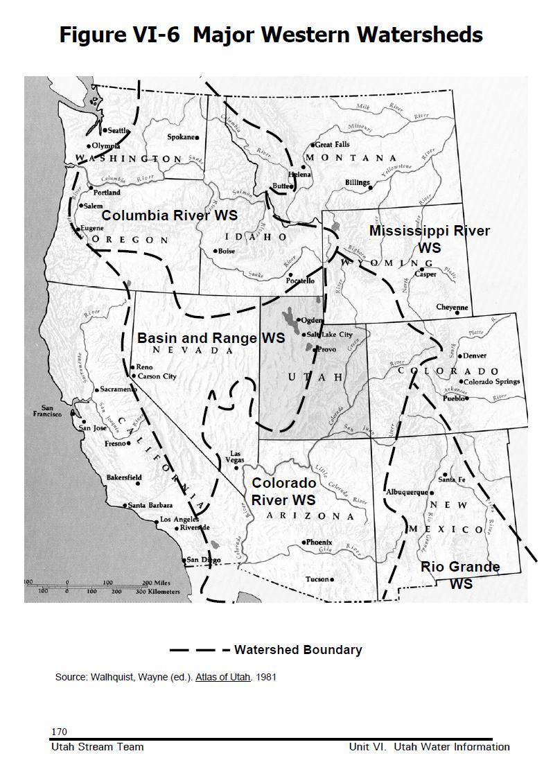
6 However, dams and reservoirs dramatically alter the stream or river and its surrounding watershed. Dams turn free-flowing streams and rivers into lake-like environments. Surface temperatures increase, bottom temperatures decrease and dissolved oxygen levels drop. Sediment and organic matter is trapped upstream of the dam, producing clear water downstream. For naturally turbid rivers, such as the Colorado and San Juan Rivers, this clear water changes the physical structure of the channel. Instead of supplying sediment to the floodplains and channels, the stream scours it away. This results in a narrower, faster channel. Dams, by design, reduce downstream flooding. Without flooding, backwaters and side channels, which are important fish nurseries, can t form. Also, beaches and riparian zones fail to receive essential supplies of sediment. Utah Watersheds Refer to Figure VI-6. You will see how Utah s watersheds compare to other western watersheds. Figure VI-7 illustrates the major watersheds and mainstream rivers within Utah. Where does our water come from? Utah depends primarily on precipitation for its water supply. Heavy snowfall in the mountains melts in late spring, filling streams and rivers which, in turn, fill reservoirs and aquifers. Utah s water supply also varies considerably from place to place. Some mountain areas may receive as much as 50 inches of precipitation in a year while the desert areas receive less than 10 inches. Desert soils, which lack organic matter and vegetative cover, have a difficult time trapping runoff. Much of the precipitation runs directly into an outlet without first infiltrating the soil for use by vegetation. What are Utah s major watersheds? Two principal watersheds divide Utah: the Great Basin and the Colorado River Watersheds. The Colorado River watershed flows into the Sea of Cortez in Mexico. The Great Basin watershed has no outlet it terminates in inland bodies of water, such as the Great Salt Lake and Sevier Lake. The Great Basin is the only major watershed in the United States that does not empty into an ocean. A third major watershed, the Columbia River Basin, occupies a small portion of northwest Utah. The Great Basin System The Great Basin System collects water from a vast area of the West, including five Utah watersheds (three of which the Bear, Jordan and Weber flow into the Great Salt Lake). The Colorado River System The main stem of the Colorado River System is the Colorado River itself. The Colorado originates on the western slope of the Continental Divide in Rocky Mountain National Park and empties into the Sea of Cortez in Mexico. The major tributary of the Colorado, the Green River, originates in the Wind River Range in Wyoming. The Green has many large tributaries of its own the Yampa, Duchesne, Uinta, White, San Rafael and Price Rivers. The Colorado and Green Rivers meet in Canyonlands National Park, where they have carved deep canyons out of the soft sedimentary rock. Below the confluence with the Green, the Colorado is fed by the Dolores, Dirty Devil, Escalante and San Juan Rivers. Lake Powell, the reservoir created by Glen Canyon Dam, backs-up the last 150 miles of the Utah portion of the Colorado River.
7
8