Chester Bridge Environmental Assessment (EA) CAG Meeting #2. October 12, 2017
|
|
|
- Gavin Booth
- 5 years ago
- Views:
Transcription
1 Chester Bridge Environmental Assessment (EA) CAG Meeting #2 October 12, 2017
2 Agenda Introductions Purpose & Need review and Merger Approval Review of the Conceptual Alternatives Recap of the Public Meeting Engineering Data Gathering and Analysis Update Environmental Data Gathering and Analysis Update Purpose & Need Screening Criteria Next Steps 2
3 Purpose and Need 3
4 Project Study Area

5 Major Elements of Study Area Major Study Area Elements
6 Project Purpose The Chester Bridge EA is a transportation study that will investigate and identify improvements intended to develop a safe and reliable Route 51 crossing of the Mississippi River. Overall, the purpose of the Chester Bridge EA is to: Improve the reliability of the crossing Improve the functionality of the crossing
7 Project Need The Route 51 crossing is too narrow for current standards The Route 51 crossing is in poor condition Route 51 is prone to flood related closures The Route 51 crossing is important to local and regional connectivity
8 The Route 51 Crossings Are Too Narrow for Current Design Standards


9 Narrow Travel Lanes Existing bridges have 22 wide decks

10 Lack of Emergency Shoulder Lanes Accidents and/or stalled vehicles Maintenance Photo credit: Google Earth
11 Approach Span Alignments Curve throughout the Horse Island Chute Bridge and both approaches Encroachment into opposing travel lane


12 Bike/Pedestrian Access Important bicycle resources U.S. Bicycle Route 76 and Illinois Mississippi River Trail
13 The Route 51 Mississippi River Crossing is in Poor Condition
14 Existing Route 51 Mississippi River Bridge Conditions MoDOT s 2016 Bridge Inventory and Inspection System reports the following conditions for the Chester Bridge (L0135): Deck condition: Poor (4/9) Superstructure condition: Poor (4/9) Substructure condition: Poor (4/9) Bridge is scour critical; bridge foundations determined to be unstable The Chester Bridge has been placed on the MoDOT List of Poor Bridges because of historically documented poor conditions
15 Route 51 is Prone to Flood Related Closures
16 Bois Brule Levee and Drainage District US Army Corps of Engineers operates the Bois Brule Levee and Drainage District Cares for the maintenance of the levees and chutes Bois Brule Levee and Drainage District protects approximately 26,000 acres At Route 51, the elevation of the road is lower than the top of the levee Creates a gap in the levee To cover this gap, a temporary flood wall is placed across the road closing Route 51


17 Route 51 Temporary Flood Wall Four occurrences of flood gauge at or above 44 feet Closure of Route 51 at 44 feet on the Chester Gauge 1973, 1993, 2015, 2017 Duration of most recent: 12/28/15 1/4/16 and 5/4/17 5/10/17 Closures result in 100+ mile detours
18 The Route 51 crossing is important to local and regional connectivity

19 Local and Regional Connectivity Access to/from Chester Businesses include Gilster Mary Lee, Conagra, and Menard Correctional Center Schools Farm equipment Connection to truck bypass in Chester Access to I 55 Access to SE Missouri and SW Illinois
20 Conceptual Alternatives
21 Logical Termini FHWA issues guidelines in designating logical termini for a study. They serve as rational end points for a project and serve as general geographical boundaries for a review of any environmental impacts caused by the study. Based on these criteria, the logical termini for the Chester Bridge EA are: In Missouri, the intersection of Route 51 and Perry County Roads 239/944. In Illinois, the intersection of Route 150 and Taylor Street.
22 Types of Alternatives to be Considered No build Routine maintenance only, no improvements Rehabilitate the existing bridges Mississippi River and Horse Island Chute bridges Structural fixes to the existing bridges No widening of the existing bridges New bridges Either upstream, down stream, or at present location 2 2

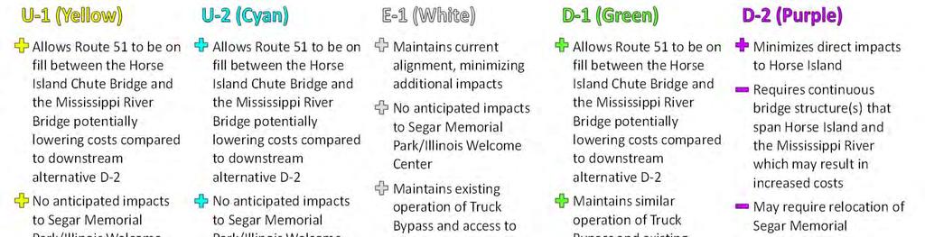
23 Conceptual Alternatives
24 Bridge Type and Aesthetic Treatments The type of bridge will not be determined in the NEPA Document (If a new bridge is the Preferred Alternative) Suitable bridge types will be identified based on cost, navigation, and other engineering factors Bridge type will be determined during design Aesthetic specifics will not be identified in the NEPA Document Aesthetic details will be part of the design phase Aesthetic enhancements beyond what is required to accomplish the project goals would be funded by the local communities 2 7


25 POTENTIAL BRIDGE TYPES Tied Arch Continuous Through Truss Extradosed Cable Stay Segmental Girder Note: Potential bridge types may be further limited by FAA and US Coast Guard clearance requirements 2 6
26 Public Information Meeting #1
27 Public Information Meeting #1 8/24/ stakeholders in attendance 19 elected officials also in attendance Very supportive of the project General comments: The bridges are too narrow Road closures due to flooding are a major concern The Mississippi River Bridge is in poor condition
28 Engineering Update Based on the project s Purpose and Need, logical termini, and study area, a series of Conceptual Alternatives are being developed. The Conceptual Alternatives represent the wide range of initial alternatives that could potentially address the transportation needs established by the study.
29 Traffic Analysis Traffic Volumes Estimates of average daily traffic in vehicles per day (vpd) Current year (2017) 6,700 vpd Design year (2042) 7,700 vpd Trucks approximately 20 22% of total traffic Traffic Analysis Roadway segments and intersections based on Level of Service (LOS) All Segments and Intersections LOS C or better Two Lane roadway/bridge meets and exceeds MoDOT and IDOT design criteria beyond design year 2042
30 Safety Analysis Crash data provided by MoDOT and IDOT for the five year period of Between Route 51/PCR 238 intersection (MO) and Route 150/Taylor Street intersection (IL) 46 Total Crashes Reported : (1) Fatal, (1) Disabling Injury, (10) Minor Injury, (34) Property Damage Only Noteworthy Findings Between Perry County Roads 238/946 in MO & the IL end of the Chester Bridge Over 50% of crashes (13/25) are head on or opposite direction sideswipe Potentially attributable, in part, to narrow travel lanes At and near the entrance to the gas stations south of PCR crashes, representing 31% of the MO crashes and 21% of the overall crashes Potential safety issues due to lack of shoulders Disabled vehicles, emergencies, roadway and bridge maintenance, bicycle and pedestrian users
31 Typical Section Bridge Section is assumed to be 40 to 44 feet wide: Two 12 foot Travel Lanes 8 10 foot Shoulders Shoulders would allow bicyclists and pedestrians to cross the bridge without using the vehicular travel lanes. Roadway Section is assumed to be Two Way Rural Minor Arterial Roadway: Design Speed of 45 mph to be maintained Existing intersections and direct access to the roadways for individual driveways will be maintained, to the extent practicable
32 Typical Section
33 Further Design, Analysis, and Screening Roadway alignments and compatibility with potential bridge types Coast Guard and FAA Requirements Navigation channel clearances (width, height) Restrictions on pier locations Compatibility of existing bridge with potential reuse Height restrictions Screening of Conceptual Alternatives Alternatives determined to satisfy the study s Purpose and Need will be advanced for further consideration Other key environmental impacts may also be considered in screening
34 Environmental Update Based on Agency Coordination and Field Reviews, the Following Important Resources May Impact the Development and Evaluation of Alternatives

35 NEPA Umbrella Other laws have established interlocking or overlapping requirements Solid Waste Disposal Act Resource Conservation and Recovery Act of 1976 Comprehensive Environmental Response, Compensation and Liability Act Emergency Planning and Community Right to Know Act of 1986 National Historic Preservation Act Economic, Social and Environmental Effects Highway Noise Standards State Noise Standard Public Hearing Requirements Section 9 Bridge Permits Section 7, Endangered Species Act, (FWS) Rivers and Harbors Act, Section 10 (COE, USCG) Archaeological and Historic Preservation Act Archaeological Resources Protection Act Title VI of Civil Rights Act of 1964 Uniform Relocation Assistance and Real Property Acquisition Policies Act of 1970 Americans with Disabilities Act Executive Order (Environmental Justice) Section 4(f) of USDOT Act (49 USC 303) Clean Air Act Safe Water Drinking Act Farmland Protection Policy Act Section 4(f) of US DOT Act Section 6(f) of the Land and Water Conservation Fund Act (LWCFA). Conformity (CAAA) Executive Order 11990, Wetlands Clean Water Act, Sections 401 & 404 wetlands (States, COE) Executive Order 11988, Floodplains Executive Order Federal Actions to Address Environmental Justice in Minority Populations and Low Income Populations, February
36 Conceptual Alternatives and Important Resources
37 Cultural and Human Resources There is moderate potential for prehistoric and historic archaeology sites on the terraces and on Horse Island, anywhere in the study area. South of the current bridge is the historic town of Claryville. A cemetery is located near the study area. In the river (south of the bridge) are the remains of the ferry Belle of Chester. The remains of the ferry have been seen at low water. The Segar Memorial Park is an important local resource and a property covered by Section 4(f).
38 Section 4(f) of the Department of Transportation Act of 1966 Intended to preserve the natural beauty of the countryside and public park and recreation lands, wildlife and waterfowl refuges, and historic sites. To be Section 4(f) eligible, the property must be publicly owned and used for public recreational purposes. The Segar Memorial Park is owned and administered by the City of Chester. It is included in the city s roster of recreational amenities. Federally funded actions cannot impact Section 4(f) eligible sites unless there is no feasible and prudent alternative. Impacts covered by Section 4(f) include the acquisition of land or negatively affecting amenities.
39 Natural Resources The Mudd s Landing Illinois Natural Area Inventory (INAI) site occurs within the Mississippi River between river mile 120 and 106. As a Category II INAI site it may provide habitat for endangered species. Previous projects in this portion of the river received a recommendation from the U.S. Fish & Wildlife Service to avoid river work between April 15 th and June 30 th. Wetlands are regulated by the Clean Water Act and are present throughout Horse Island, particularly south of the existing bridge. Coles Mill is a geological area just downstream of the study area. Bald Eagle Nesting was observed near, but outside, the study area on Kaskaskia Island.
40 Purpose and Need Screening
41 Purpose and Need Screening Matrix Will be used to screen the Conceptual Alternatives Purpose Screening Criteria Performance Measures Address the design deficiencies of the existing bridge Is the river crossing improved? Does it comply with current MoDOT Design Standards? Are 12 foot lanes provided? (y/n) Are 8 10 foot shoulders provided? (y/n) Can bike/pedestrian facilities be accommodated? (y/n) Address the poor condition of the existing bridge Is the bridge condition improved? Does it comply with current MoDOT Design standards? Are the deck and superstructure improved to a good condition or better 7 of 9? (y/n) Are the bridge foundations stable? (y/n) Is the anticipated lifespan of the proposed improvements greater than 25 years? (y/n) Is the load carrying capacity adequate? (y/n) Is current seismic design criteria met? (y/n)
 Maintain important local and regional connectivity Are important regional connections maintained?")
42 Purpose and Need Screening Matrix Purpose Screening Criteria Performance Measures Minimize the flood related closures of Route 51 Is the gap in the Bois Brule Levee corrected? Is the need for the existing temporary flood wall eliminated? (y/n) Maintain important local and regional connectivity Are important regional connections maintained? Are important local connections maintained? Is the distance and spacing in relation to I 55 adequate? (y/n) Is the Truck Bypass maintained? (y/n) Is access to Chester maintained? (y/n) Can the crossing be maintained during construction? (y/n) Is access to Bois Brule Bottoms and Kaskaskia Island maintained? (y/n) Is access to the Mississippi River maintained? (y/n) Is farm equipment access to Horse Island maintained? (y/n) Is farm equipment access to Bois Brule maintained? (y/n) Is access to Menard Correctional Center maintained? (y/n)
43 Next Steps
44 Anticipated Project Schedule Study Begins Spring 2017 Public Meeting #1 August 24, 2017 Purpose and Need Developed September 2017 Reasonable Alternatives Early 2018 Public Meeting #2 Spring 2018 Preferred Alternative and EA Late 2018 Public Hearing Early 2019 Study Complete Spring
45 Adjourn 45