FieldDoc.org User Guide - for 2018 NFWF Chesapeake Bay Stewardship Fund Applicants -
|
|
|
- Teresa Harrison
- 5 years ago
- Views:
Transcription
1 FieldDoc.org User Guide - for 2018 NFWF Chesapeake Bay Stewardship Fund Applicants - Table of Contents (click to go to page) Background 2 Step 1: Register for a FieldDoc account 3 Step 2: Create the Project Plan for your grant application.3 Step 3: Enter basic information about your proposed grant project..4 Step 4: Add a restoration site(s) for your project...5 Step 5: Select a known or representative restoration site and enter site data 5 Step 6: Add Best Management Practice (BMP) information at your project site.9 Step 7: Select BMPs for your site 10 Step 8: Add planning data for the BMP at your site 12 Step 9: Enter planning data for the BMP at your site..12 Bank Stabilization...13 Bioretention.14 Enhanced Stream Restoration.15 Non-Tidal Wetlands 19 Forest Buffer...20 Grass Buffer 21 In-Stream Habitat...22 Livestock Exclusion 23 Urban Homeowner..25 Shoreline Management...27 Step 10: Generate metrics for entry into Easygrants
2 FieldDoc.org User Guide - for 2018 NFWF Chesapeake Bay Stewardship Fund Applicants - This guide provides step-by-step instructions for the use of FieldDoc.org to estimate nutrient and sediment load reductions and associated interim metrics for applicants to the 2018 Chesapeake Bay Stewardship Fund administered by the National Fish and Wildlife Foundation (NFWF). It offers complete instructions from initial FieldDoc.org account registration through FieldDoc.org data entry, and input of FieldDoc.org outputs into NFWF s online Easygrants system. It also provides links to additional information and documentation necessary to understand land uses, Best Management Practice definitions, and modeling approaches used to calculate nutrient and sediment load reductions. This guide is intended to serve as a supplement to the online help tools available at help.fielddoc.org, providing further context on how NFWF expects interested grantees to use FieldDoc.org for generating nutrient and sediment load reductions and associated interim metrics for their 2018 Stewardship Fund grant applications. Additional guidance and training will be provided for grants successfully awarded through the 2018 Stewardship Fund on how FieldDoc.org will be used for ongoing grant reporting and tracking. Additional functionality will be providing to increase the utility of FieldDoc.org for project and grants management. It is important to note that FieldDoc.org does not replace NFWF s Easygrants grants management and reporting tool, but instead offers an additional tool to ensure the quality and consistency of data and information reported via Easygrants for grant applications and interim and final reporting. This guide will provide information on how to utilize FieldDoc outputs for Easygrants data entry. Where specific fields are required in FieldDoc.org, this guide will offer further Field Entry, highlighted in yellow throughout the document for quick reference. FieldDoc.org and associated data collection methodologies are further detailed in Metrics and Protocols for Progress Assessment in Chesapeake Bay Stewardship Fund Grants available at NFWF s Chesapeake Bay Stewardship Fund website. Example Field Entry 1. What is the name of your project? Copy and paste your Project Title from Easygrants 2. Which funder is providing the grant? Select National Fish and Wildlife Foundation 3. What type of grant are you requesting? Select the specific NFWF program to which you re applying 4. Please provide a short project description. Copy and paste your Project Description from Easygrants 2

3 Step 1. Register for a FieldDoc.org account. Registration can be found at Be sure to complete the registration process with a valid , first name and last name, organization, and password. Important: If you are an existing user, we ask that you login, and ensure that your full account information is completed. For new users, visit for account registration details. Step 2. Create the Project Plan for your grant application. Once logged into your FieldDoc.org account homepage, click Create Project in the upper right-hand corner to enter data on your Stewardship Fund grant application. In the FieldDoc.org workflow, the Project Plan is commensurate with your NFWF grant project. 3
4 Step 3. Enter basic information about your proposed grant project. Enter basic information about your proposed grant project on the Project Overview page. This information should be consistent with what you ve entered in Easygrants. Click Save Changes when you re complete. 1. What is the name of your project? 2. Which funder is providing the grant? 3. What type of grant are you requesting? 4. Please provide a short project description. Copy and paste your 5-digit project or proposal number Project Title from Easygrants. Select National Fish and Wildlife Foundation. Select the specific NFWF program to which you re applying. Copy and paste your Project Description from Easygrants. 4

5 Step 4. Add a restoration site(s) for your project You can add as many sites to your proposed project as you d like at this stage. However, NFWF will only require that each applicant identify at least one site, per the guidance provided below. Click Create Site in the upper right-hand corner to add your first site. Step 5. Select a known or representative restoration site and enter site data. Because FieldDoc.org uses geographic information to generate baseline nutrient and sediment loading information and calculate load reductions, you ll need to identify your specific restoration site(s) or, at least, a site(s) representative of the landscape or location in which you plan to work. FieldDoc.org provides detailed loading information down to the land-river segment scale, a combination of county, physiographic, and watershed boundaries used by the Phase 5.3 Chesapeake Bay Watershed Model. There are roughly 1,000 individual land-river segments delineated in FieldDoc.org with an average area of roughly 66 square miles or 42,000 acres, though the size and scale of segments varies considerably based on geography, political subdivisions, and local hydrology. Importantly, nutrient and sediment load reduction calculations in FieldDoc.org do not vary significantly across adjacent or connected land-river segments. Moreover, the selection of a specific site within a land-river segment will have no impact on the load reduction calculations for that site or specific BMPs at that site. That is, for load reduction purposes in FieldDoc.org, it matters only which land-river segment in which you re working, and not exactly where within that land-river segment you re proposing to work. For many Stewardship Fund applicants, a land-river segment as delineated in FieldDoc.org may wholly capture the proposed project area. However, NFWF understands that some projects may propose work across several segments. Moreover, some projects may not have specific restoration sites yet identified, or may propose work 5

6 at a larger scale with specific restoration sites identified through the term of the grant project. To address these special cases, NFWF advises Stewardship Fund applicants to use the following decision tree to determine how best to identify either a known restoration site or representative restoration sites in FieldDoc.org: To help answer these questions, scroll down to Question 5 and the associated the mapping tool at the bottom of the Site Overview page. Here, you can either search for specific areas using the search function, or manually move the blue pin to identify your restoration site. If you chose to use the search function, autocomplete functionality will allow you to select the appropriate area as you type. 6
,")

7 Example of selected site (blue pin), with land-river segment boundary outlined. 7
8 Once you ve determined whether you plan to use either a known or a representative restoration site, input basic information about your site. 1. What is the name of this site? 2. Please describe this site. 3. What is the nearest city? 4. What county is this site in? Provide an appropriate name for the site. If you have a known restoration site, this name could be quite specific (e.g. Miller s Farm, Staunton Bioretention, Muddy Branch Stream Restoration). If you re instead creating one or more representative sites, you could enter something like Representative Site 1 or Example Site A. Simply describe whether this is a site of know restoration work, or whether it s representative of the landscape or location in which you plan to work. Enter the nearest city. Enter the county. Click Save Changes in the lower right-hand corner to save your site information. 8
9 Step 6. Add Best Management Practice (BMP) information at your project site. With your known or representative site(s) identified, click Create Practice in the upper right-hand corner of the Site Overview page to add specific BMPs to your site. 9
10 Step 7. Select BMPs for your site. Use the dropdown menu to select which of the priority BMPs you plan to implement at your site. FieldDoc.org currently allows you to calculate nutrient and sediment load reductions for the following practices: Other Other Conservation Practice: BMP or conservation practice that is not listed under the Chesapeake Phase practices below. Chesapeake Phase Bank Stabilization: Vegetative stabilization on stream channel banks that may include grading and shaping of the bank to achieve proper slope and seeding conditions. Bioretention: A soil and plant-based stormwater control measure employed to capture and filter runoff. Enhanced Stream Restoration: Engineering approaches to mimic natural conditions, improve nutrient cycling, and/or improve connections with the floodplain. Forest Buffer: A wooded buffer zone along streams for protection and filtering action from surrounding land. Grass Buffer: Vegetative buffers that are located along the banks of water courses to filter runoff, anchor soil particles, and protect banks against scour and erosion In-stream Habitat: Information/practices intended to improve aquatic habitat for priority species like Eastern brook trout, river herring, native oysters, and black ducks. no load reductions will be associated with this BMP and it can be used instead to track implementation of habitat restoration efforts for specific species of interest. Livestock Exclusion: A system of structural and/or management practices that reduces direct deposition of livestock manure in stream, including stream exclusion fencing at minimum. Non-Tidal Wetlands: Manipulation of the physical, chemical, or biological characteristics present to develop a wetland that did not previously exist or return natural/historic functions to a former wetland. Other Agricultural Practices: Other Agricultural Practices serves as a catch all best management practice (BMP) that can be applied to your restoration site to estimate nutrient and sediment reductions. The BMP consist of over 113 practices that can be actively planned and installed to FieldDoc projects. Shoreline Management: Comprised of a combination of tidal wetland BMPs and living shorelines. Stormwater Management: Serves as a catch all best management practice (BMP) that can be applied to your restoration site to estimate nutrient and sediment reductions from runoff reduction and stormwater treatment. Urban Homeowner: A collection for several low-impact design stormwater control measures including rain gardens, permeable pavement, downspout disconnection, urban nutrient management, conservation landscaping, tree planting, and impervious surface removal. Click Save Changes to save your added BMP. After adding one BMP, additional BMPs can be added to the site by clicking back to the Site Overview page, then on the Create Practice button in the upper right-hand corner of the Site Overview page. 10
11 11
12 Step 8. Add planning data for the BMP at your site. Click the Add Planning Data button in the bottom left-hand corner of the Practice Overview page. Step 9. Enter Planning data for the BMP at your site. Enter basic information on planned BMP implementation at your site. Necessary information will vary for each BMP. What follows is a summary of what should be entered in key field for each BMP type. For each BMP, be sure to click Save Changes in the lower left-hand corner to save planning data. 12
13 Planning Data Entry Other Conservation Practice Report Date Measurement Period WIP Reporting Agency Methods for Calculating Nutrient and Sediment Reductions New Other Conservation Practice New Custom Metric Enter the proposed start date for your grant. Select Planning Select the appropriate agency, given the jurisdiction in which you intend to work. If you are unsure of your jurisdiction or are proposing work in multiple jurisdictions, leave this field blank. Enter the model used to calculate. Enter description of model used to calculate. Provide link to model. Input reduction numbers. Add additional associated Conservation Practices Enter metric used to measure Other Conservation Practice 13
14 Planning Data Entry Bank Stabilization BMP Report Date Measurement Period WIP Reporting Agency Length of Streambank Eroding Bank Height Eroding Bank Horizontal Width LER Evaluation Basis Lateral Erosion Rate Soil Bulk Density* Soil N Content Soil P Content Enter the proposed start date for your grant. Select Planning Select the appropriate agency, given the jurisdiction in which you intend to work. If you are unsure of your jurisdiction or are proposing work in multiple jurisdictions, leave this field blank. Enter the length of your planned bank stabilization BMP. Enter the height of the eroding bank at the site under baseline conditions. Enter the horizontal width of the eroding bank at the site under baseline conditions. Select the method used to calculate lateral erosion rate. Enter the lateral erosion rate at your site under baseline conditions. Enter the estimated soil bulk density for the eroding bank. Enter the estimated soil nitrogen content for the eroding bank. Enter the estimated soil phosphorus content for the eroding bank. * Information on estimated bulk densities for major soil types can be found here. 14
15 Planning Data Entry Bioretention BMP Report Date Measurement Period WIP Reporting Agency Area Draining to the Practice (Impervious Area) Total Drainage Area Rainfall Depth Treated Practice Area Enter the proposed start date for your grant. Select Planning Select the appropriate agency, given the jurisdiction in which you intend to work. If you are unsure of your jurisdiction or are proposing work in multiple jurisdictions, leave this field blank. If you have a known restoration site identified, enter the impervious area draining to the planned bioretention practice at that site. If you are instead using a representative site, enter the total impervious area draining to bioretention practices you plan to implement for the entire project. If you have a known restoration site identified, enter the impervious area draining to the planned bioretention practice at that site. If you are instead using a representative site, enter the total area draining to bioretention practices you plan to implement for the entire project. Enter the depth of rainfall treated by the planned bioretention practice(s). If you have a known restoration site identified, enter the total area of the bioretention practice. If you are instead using a representative site, enter the total area of bioretention practices you plan to implement for the entire project. 15
16 Planning Data Entry Enhanced Stream Restoration BMP Baseline Condition For the Enhanced Stream Restoration BMP, data on both baseline site conditions and planned restoration activities must be provided to generate load reduction calculations. On the Practice Overview page, click Add Measurement Data to begin adding data on baseline site conditions. Report Date Enter the proposed start date for your grant. Measurement Period Select Planning WIP Reporting Agency Select the appropriate agency, given the jurisdiction in which you intend to work. If you are unsure of your jurisdiction or are proposing work in multiple jurisdictions, leave this field blank. Stream Width at Bankfull Enter the stream width at bankfull under baseline conditions. Stream Width at Mean Enter the stream width at mean base flow under baseline conditions. Base Flow Project Left Bank Height Enter the left bank height at the site under baseline conditions. Left Bankfull Height Enter the left bankfull height at the site under baseline conditions. Project Right Bank Height Enter the right bank height at the site under baseline conditions. Right Bankfull Height Enter the right bankfull height at the site under baseline conditions. Bulk Density of Soil in Enter the bulk density of soil in the hyporheic zone. Hyporheic Zone* Fraction of Runoff Enter the fraction of runoff treated in the channel under baseline conditions. Carried in the Channel Fraction of Runoff Enter the fraction of runoff treated in the floodplain under baseline conditions. Treated in the Floodplain * Information on estimated bulk densities for major soil types can be found here. 16

17 Planning Data Entry Enhanced Stream Restoration BMP Planned Condition Once you ve entered data on baseline site conditions for the Enhanced Stream Restoration BMP, click Add Measurement Data on the Practice Overview page to enter information on your planned stream restoration project. On the next page, use the Measurement Period drop down menu to select Installation. 17
18 Enter installation data for the planned stream restoration project. Report Date Enter the proposed start date for your grant. Measurement Period Select Planning WIP Reporting Agency Select the appropriate agency, given the jurisdiction in which you intend to work. If you are unsure of your jurisdiction or are proposing work in multiple jurisdictions, leave this field blank. Stream Width at Bankfull Enter the estimated stream width at bankfull after the planned restoration. Stream Width at Mean Base Flow Enter the estimated stream width at mean base flow after the planned restoration. Project Left Bank Height Enter the estimated left bank height at the site after the planned restoration. Left Bankfull Height Enter the estimated left bankfull height at the site after the planned restoration. Project Right Bank Height Enter the estimated right bank height at the site after the planned restoration. Right Bankfull Height Enter the estimated right bankfull height at the site after the planned restoration. Bulk Density of Soil in Hyporheic Enter the bulk density of soil in the hyporheic zone. Zone* Stream Length Reconnected at Enter the fraction of runoff treated in the channel Floodplain Fraction of Runoff Treated in the Enter the fraction of runoff treated in the floodplain Floodplain Connected Floodplain Surface Area Enter the surface area of floodplain connected through the planned restoration. Watershed Impervious Area Enter the watershed impervious area draining to the site. Watershed Pervious Area Enter the watershed pervious area draining to the site. Fraction of Runoff Carried in the Enter the fraction of runoff treated in the channel after the planned restoration. Channel Fraction of Runoff Treated in the Enter the fraction of runoff treated in the floodplain after the planned restoration. Floodplain * Information on estimated bulk densities for major soil types can be found here. 18
19 Planning Data Entry Forest Buffer BMP Report Date Measurement Period WIP Reporting Agency Existing Land Use* Upland Land Use* Length of Buffer Average Buffer Width Enter the proposed start date for your grant. Select Planning Select the appropriate agency, given the jurisdiction in which you intend to work. If you are unsure of your jurisdiction or are proposing work in multiple jurisdictions, leave this field blank. Select the existing land use for the planned forest buffer(s). If you are using a representative restoration site(s), please provide your best estimate for a representative site. Select the land use directly upland from your planned forest buffer(s). If you are using a representative restoration site(s), please provide your best estimate for a representative site. If you have a known restoration site, enter the length of your planned buffer at that site. If you are using a single representative restoration site, enter the total length of buffer you plan to implement for the entire project. If you are using multiple representative restoration sites, the total length of buffer across all sites should equal the total length you plan to implement for the entire project. If you have a known restoration site, enter the average width of your planned buffer at that site. If you are using a representative restoration site(s), enter the average width of buffer you plan to implement for the entire project. Estimate the total number of trees planted in your planned buffer(s). Number of Trees Plants * Information on land use definitiations used in FieldDoc.org can be found here. For the purposes of modeling nutrient and sediment load reductions, each BMP may only be applied to a limited set of land uses. 19

20 Planning Data Entry Grass Buffer BMP Report Date Measurement Period WIP Reporting Agency Existing Land Use* Upland Land Use* Length of Buffer Average Buffer Width Enter the proposed start date for your grant. Select Planning Select the appropriate agency, given the jurisdiction in which you intend to work. If you are unsure of your jurisdiction or are proposing work in multiple jurisdictions, leave this field blank. Select the existing land use for your planned grass buffer(s). If you are using a representative restoration site(s), please provide your best estimate for a representative site. Select the land use directly upland from your planned grass buffer(s). If you are using a representative restoration site(s), please provide your best estimate for a representative site. If you have a known restoration site identified, enter the length of your planned buffer at that site. If you are using a representative restoration site, enter the total length of buffer you plan to implement for the entire project. If you are using multiple representative restoration sites, the total length of buffer across all sites should equal the total length you plan to implement for the entire project. If you have a known restoration site identified, enter the average width of your planned buffer at that site. If you are using a representative restoration site(s), enter the average width of buffer you plan to implement for the entire project. * Information on land use definitiations used in FieldDoc.org can be found here. For the purposes of modeling nutrient and sediment load reductions, each BMP may only be applied to a limited set of land uses. 20
21 Planning Data Entry In-stream Habitat BMP The In-Stream Habitat BMP is unique in FieldDoc in that it is not used to calculate estimated nutrient and sediment load reductions. Instead, this BMP is a catchall for several practices intended to improve aquatic habitat for priority species like Eastern brook trout, river herring, native oysters, and black ducks. Applicants interested in estimating load reductions from associated practices reference here should enter data through each individual BMP separately (e.g. Enhanced Stream Restoration BMP, Non-Tidal Wetlands BMP) Report Date Measurement Period WIP Reporting Agency Type of Structural Feature Units Extent Acres Protected Under Long-term Easement Habitat Restoration Target Species (1) Habitat Restoration Target Species (2) Acres of Habitat Restored Acres of Wetlands Restored Miles of Living Shoreline Restored Miles of Stream Opened Acres of Oyster Habitat Restored Fish Passage Improvements Eastern Brook Trout Enter the proposed start date for your grant. Select Planning Select the appropriate agency, given the jurisdiction in which you intend to work. If you are unsure of your jurisdiction or are proposing work in multiple jurisdictions, leave this field blank. Select the type of structural habitat improvement feature(s) you plan to implement. Enter the number of each structural habitat improvement feature(s) you plan to implement. Enter the extent of each structural habitat improvement feature(s) you plan to implement. Enter the number of acres you plan to protect under long-term easement at the site. Identify the primary species targeted for habitat restoration. Identify the secondary species targeted for habitat restoration. Enter the number of acres of habitat you plan to restore at the site. Enter the number of acres of wetland you plan to restore at the site. Enter the number of miles of living shoreline you plan to restore at the site. Enter the number of stream miles you plan to open for improved fish passage. Enter the number of acres of oyster reef you plan to restore. Enter the number of fish passage barriers you plan to rectify and an estimate of the number of fish for targeted species that will move past existing barriers. Enter the number of watersheds in which you plan to reintroduce Eastern brook trout and the number of habitat units improved through planned restoration efforts. 21
22 Planning Data Entry Livestock Exclusion BMP Report Date Measurement Period WIP Reporting Agency Existing Land Use* Upland Land Use* Type of Livestock Number of Livestock Average Weight Length of Stream with Livestock Access Average Buffer Width Buffer Type Length of Fencing to be Installed Stream Access (days/month) Stream Access (hours/day) Enter the proposed start date for your grant. Select Planning Select the appropriate agency, given the jurisdiction in which you intend to work. If you are unsure of your jurisdiction or are proposing work in multiple jurisdictions, leave this field blank. Select the existing land use for your planned livestock exclusion practice. If you are using a representative restoration site(s), please provide your best estimate. Select the land use directly upland from your planned livestock exclusion practice. If you are using a representative restoration site(s), please provide your best estimate. Enter the type of livestock that will be excluded from the stream. If you are using a representative restoration site(s), please provide your best estimate. Enter the number of livestock that will be excluded from the stream. If you are using a single representative restoration site, please provide your best estimate. If you are using multiple representative restoration sites, the total number of livestock should equal the total number you plan to exclude for the entire project. Enter the average weight of livestock that will be excluded from the stream. If you are using a representative restoration site(s), please provide your best estimate. Enter the length of stream with livestock access under the baseline condition. If you are using a single representative restoration site, please estimate the length of stream with livestock access for the entire project. Enter the average forest or grass buffer width that will be fenced. If you are using a representative restoration site(s), please provide your best estimate. Enter the type of buffer that you plan to implement in the fenced area. If you are using a representative restoration site(s), please provide your best estimate. If you have a known restoration site identified, enter the length of your fencing to be installed at that site. If you are using a single representative restoration site, enter the total length of fencing you plan to install for the entire project. If you are using multiple representative restoration sites, the total length of fencing to be installed across all sites should equal the total length you plan to implement for the entire project. Enter the days livestock have access to the stream under baseline conditions. If you are using a representative restoration site(s), please provide your best estimate. Enter the hours per days for each month that livestock have access to the stream under baseline conditions. If you are using a representative restoration site(s), please provide your best estimate. * Information on land use definitiations used in FieldDoc.org can be found here. For the purposes of modeling nutrient and sediment load reductions, each BMP may only be applied to a limited set of land uses. 22
23 Planning Data Entry Non-Tidal Wetlands BMP Report Date Measurement Period WIP Reporting Agency Total Wetland Surface Area Type of Non-Tidal Wetlands Project Upland Land Use* Acres Enter the proposed start date for your grant. Select Planning Select the appropriate agency, given the jurisdiction in which you intend to work. If you are unsure of your jurisdiction or are proposing work in multiple jurisdictions, leave this field blank. Enter the total acreage of wetlands surface area to be created or restored at the site. Note that each site may include up to four individual wetlands creation or restoration practices. For each individual wetlands practice at the site, select the type of wetlands practice. For each individual wetlands practice at the site, select the land use directly upland from your planned wetland(s). If you are using a representative restoration site(s), please provide your best estimate for a representative site. For each individual wetlands practice at the site, enter the total upland acres draining to the practice. * Information on land use definitiations used in FieldDoc.org can be found here. For the purposes of modeling nutrient and sediment load reductions, each BMP may only be applied to a limited set of land uses. 23
24 24
25 Planning Data Entry Other Agricultural Practices BMP Report Date Measurement Period WIP Reporting Agency Landuse Practices and Efficiencies Installation Summary Enter the proposed start date for your grant. Select Planning Select the appropriate agency, given the jurisdiction in which you intend to work. If you are unsure of your jurisdiction or are proposing work in multiple jurisdictions, leave this field blank. If you are using the Phase Unit Area Loads model, enter the designated practice. If you are instead using a Custom Unit Area Loads model, enter the name, source, and percent of reduction. Select BMPs and efficiencies. For help, please visit the help documentation article for the Other Agricultural Practices BMP. Enter acres covered by the practice. 25
26 Planning Data Entry Shoreline Management BMP Shoreline management projects may be comprised of any combination of living shorelines and tidal wetland BMPs. Report Date Measurement Period WIP Reporting Agency Length of Living Shoreline Restored Existing Average Bank Height Existing Shoreline Recession Rate (SRR; ft/yr) Soil Bulk Density (SBD; lbs/ft3) Sand Reduction Factor (SRF) Bank Instability Reduction Factor (BIR), if applicable Existing Area of Tidal Wetlands (acres) Acres of Planted or Replanted Tidal Wetlands Type of Tidal Wetlands Project Load Reductions Enter the proposed start date for your grant. Select Planning Select the appropriate agency, given the jurisdiction in which you intend to work. If you are unsure of your jurisdiction or are proposing work in multiple jurisdictions, leave this field blank. Enter the total length of living shoreline you plan to install in feet. Enter the existing average bank height of the project area in feet. Enter the rate of existing shoreline recession in feet per year. Rates can be selected from from Virginia s Shoreline Evolution Reports (source); Maryland's Shoreline Change Maps for Tidewater Maryland (source); or measure in field. Document method used under Notes Enter the soil bulk density in lbs per square foot. If measured in field, please provide details under Notes. If field measurement is not feasible, please use the default value of 93.6 lbs/ft3 The default values of SRF by state are: (VA) and (MD, DC, DE) from WTWG, 2015; or can be based on site-specific measurements with details provided under Notes. Installed project must meet structural criteria 3 and 4 below, otherwise use BIR If relevant, please include the bank instability reduction factor. Default value is set to 1 Please enter the existing area of tidal wetlands (acres). Enter in acres the total amount of planted or replanted tidal wetlands Please select the type of tidal wetland project from the dropdown. Selections include Creation, Restoration, or Enhancement. Please ensure load reduction protocol rates are set to the appropriate rate for your BMP. Defaults are provided in the event that you do not have load reduction protocol rates. 26
27 Planning Data Entry Stormwater Management BMP Report Date Measurement Period WIP Reporting Agency Project Type (New or Re-Development) Site Reduction Classification (RR or ST) Stormwater BMPs Area draining to/treated by the BMPs Enter the proposed start date for your grant. Select Planning Select the appropriate agency, given the jurisdiction in which you intend to work. If you are unsure of your jurisdiction or are proposing work in multiple jurisdictions, leave this field blank. Select New Development or Re-Development. New development typically occurs on land without previous impervious area, whereas re-development always occurs in an area with some degree of impervious surface. Select Runoff Reduction or Stormwater Treatment. Select practices used and note on how many acres the practice will be implemented. Enter total Impervious and total Drainage area. Specific Engineering Parameter (EP) values of runoff volume captured by the project are uniquely defined for each state and should be calculated by the user according to each state's specifications, also included in CSN (2015). * Information on land use definitiations used in FieldDoc.org can be found here. For the purposes of modeling nutrient and sediment load reductions, each BMP may only be applied to a limited set of land uses. 27
28 Planning Data Entry Urban Homeowner BMP The Urban Homeowner BMP includes a number of small scale stormwater control measures that can be applied at the residential, commercial, or industrial site scale. Report Date Measurement Period WIP Reporting Agency Type Urban Homeowner Certification Rain Garden Rain Barrel Permeable Pavement Downspout Disconnection UNM Pledge UNM Pledge, High Risk Enter the proposed start date for your grant. Select Planning Select the appropriate agency, given the jurisdiction in which you intend to work. If you are unsure of your jurisdiction or are proposing work in multiple jurisdictions, leave this field blank. Select any relevant stormwater certification programs you intend to use for your project. If none apply or the program you intend to use is not listed, please select Homeowner (self). Enter the drainage area treated by rain gardens you plan to install at the site. If you are using a single representative restoration site, enter the drainage area treated by rain gardens you plan to install for the entire project area. If you are using multiple representative restoration sites, the total drainage area treated by rain gardens across all sites should equal the total length you plan to implement for the entire project. Enter the drainage area treated by rain barrels you plan to install at the site. If you are using a single representative restoration site, enter the drainage area treated by rain barrels you plan to install for the entire project area. If you are using multiple representative restoration sites, the total drainage area treated by rain barrels across all sites should equal the total length you plan to implement for the entire project. Enter the area of permeable pavement you plan to install at the site. If you are using a single representative restoration site, enter the area of permeable pavement you plan to install for the entire project area. If you are using multiple representative restoration sites, the total area of pervious pavement to be installed across all sites should equal the total area you plan to install for the entire project. Enter the area draining to downspouts you plan to disconnect at the site. If you are using a single representative restoration site, enter the area draining to downspouts you plan to disconnect for the entire project area. If you are using multiple representative restoration sites, the area draining to downspouts you plan to disconnect across all sites should equal the total area draining to downspouts you plan to disconnect for the entire project. Enter the area under urban nutrient management you plan to implement at the site. If you are using a single representative restoration site, enter the area under urban nutrient management you plan to implement for the entire project area. If you are using multiple representative restoration sites, the total area of under urban nutrient management across all sites should equal the total area you plan to implement for the entire project. Enter the high risk area under urban nutrient management you plan to implement at the site. If you are using a single representative restoration site, enter the high risk area under urban nutrient management you plan to implement for the entire project area. If you are using multiple representative restoration sites, the total high risk area of under urban nutrient management across all sites should equal the total area you plan to implement for the entire project. 28
29 Conservation Landscaping Tree Planting Impervious Surface Removal Enter the area of conservation landscaping you plan to install at the site. If you are using a single representative restoration site, enter the area of conservation landscaping you plan to install for the entire project area. If you are using multiple representative restoration sites, the total area of conservation landscaping you plan to implement across all sites should equal the total area you plan to implement for the entire project. Enter the area of tree planting you plan to install at the site. If you are using a single representative restoration site, enter the area of tree planting you plan to install for the entire project area. If you are using multiple representative restoration sites, the total area of tree planting you plan to implement across all sites should equal the total area you plan to implement for the entire project. Enter the area of impervious surface you plan to remove at the site. If you are using a single representative restoration site, enter the area of impervious surface you plan to remove for the entire project area. If you are using multiple representative restoration sites, the total area of impervious surface you plan to remove across all sites should equal the total area you plan to remove for the entire project. 29
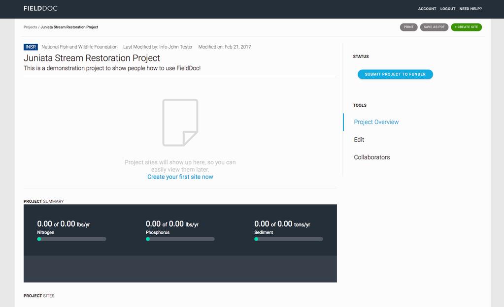
30 Step 10. Generate metrics for entry into Easygrants Once you ve entered planning data for each BMP (and additional installation data for the Enhanced Nutrient Management BMP) and clicked Save Changes, you will be taken to the Practice Overview page for that BMP at that specific site. This page captures both pre-project nutrient and sediment load data for the site, as well as planned annual nutrient and sediment reductions based on the information you ve entered. From there, click on your project page. The planned load reductions from each BMP at each site are automatically summed on the Project page under Project Summary. This information should be entered into the Easygrants Metrics section for Lbs of nitrogen/phosphorus/sediment avoided (annually). Additionally, a PDF version of this page should be uploaded to the Easygrants Downloads section for FieldDoc Project Summary. To save this page as a PDF, click Save as PDF at the top, right-hand corner of the page. 30
31 31
32 Lastly, the Practice Overview page provides information on other relevant metrics for incorporation into Easygrants under the Chesapeake Bay Metrics section of the page. 32