TABLE OF CONTENTS TABLE OF CONTENTS... I APPENDICES... III LIST OF EXHIBITS... V LIST OF TABLES... VII LIST OF ABBREVIATED TERMS...
|
|
|
- Alicia Reeves
- 5 years ago
- Views:
Transcription
1
2
3 Amendment No. 2 to Reclamation Plan Traffic Impact Analysis TABLE OF CONTENTS TABLE OF CONTENTS... I APPENDICES... III LIST OF EXHIBITS... V LIST OF TABLES... VII LIST OF ABBREVIATED TERMS... IX 1 INTRODUCTION Project Overview Analysis Scenarios Study Area Summary of LOS Deficiencies Programmed TUMF/TIF Improvements Local and Regional Funding Mechanisms METHODOLOGIES Level of Service Intersection Capacity Analysis Freeway Off-Ramp Queuing Analysis Traffic Signal Warrant Analysis Methodology Freeway Mainline Segment Analysis Methodology Freeway Merge/Diverge Ramp Junction Analysis Minimum Level of Service (LOS) CEQA Compliance and Documentation AREA CONDITIONS Existing Circulation Network City of Lake Elsinore General Plan Circulation Element Bicycle & Pedestrian Facilities Transit Service Existing (2015) Traffic Counts Intersection Operations Analysis Off-Ramp Queuing Analysis Traffic Signal Warrants Analysis Basic Freeway Segment Analysis Freeway Merge/Diverge Analysis PROJECTED FUTURE TRAFFIC Project Trip Generation Project Trip Distribution Modal Split Project Trip Assignment Background Traffic Cumulative Development Traffic Near-Term Traffic Forecasts Horizon Year (2035) Volume Development TIA Report REV.docx i
4 Amendment No. 2 to Reclamation Plan Traffic Impact Analysis 5 E+P TRAFFIC CONDITIONS Roadway Improvements Existing plus Project Traffic Volume Forecasts Intersection Operations Analysis Off-Ramp Queuing Analysis Traffic Signal Warrants Analysis Basic Freeway Segment Analysis Freeway Merge/Diverge Analysis EAP (2016) TRAFFIC CONDITIONS Roadway Improvements EAP (2016) Traffic Volume Forecasts Intersection Operations Analysis Off-Ramp Queuing Analysis Traffic Signal Warrants Analysis Basic Freeway Segment Analysis Freeway Merge/Diverge Analysis EAPC (2016) TRAFFIC CONDITIONS Roadway Improvements EAPC (2016) Traffic Volume Forecasts Intersection Operations Analysis Off-Ramp Queuing Analysis Traffic Signal Warrants Analysis Basic Freeway Segment Analysis Freeway Merge/Diverge Analysis EAPC Deficiencies and Recommended Improvements HORIZON YEAR (2035) TRAFFIC CONDITIONS Roadway Improvements Horizon Year (2035) Without Project Traffic Volume Forecasts Horizon Year (2035) With Project Traffic Volume Forecasts Intersection Operations Analysis Off-Ramp Queuing Analysis Traffic Signal Warrants Analysis Basic Freeway Segment Analysis Freeway Merge/Diverge Analysis Horizon Year Deficiencies and Recommended Improvements REFERENCES TIA Report REV.docx ii
5 Amendment No. 2 to Reclamation Plan Traffic Impact Analysis APPENDICES APPENDIX 1.1: APPROVED TRAFFIC STUDY SCOPING AGREEMENT APPENDIX 3.1: EXISTING TRAFFIC COUNTS MAY 2015 APPENDIX 3.2: EXISTING (2015) CONDITIONS INTERSECTION OPERATIONS ANALYSIS WORKSHEETS APPENDIX 3.3: EXISTING (2015) CONDITIONS TRAFFIC SIGNAL WARRANT ANALYSIS WORKSHEETS APPENDIX 3.4: EXISTING (2015) CONDITIONS BASIC FREEWAY SEGMENT ANALYSIS WORKSHEETS APPENDIX 3.5: EXISTING (2015) CONDITIONS FREEWAY MERGE/DIVERGE ANALYSIS WORKSHEETS APPENDIX 4.1: CUMULATIVE DEVELOPMENT PROJECT REQUESTS APPENDIX 4.2: POST PROCESSING WORKSHEETS APPENDIX 5.1: E+P CONDITIONS INTERSECTION OPERATIONS ANALYSIS WORKSHEETS APPENDIX 5.2: E+P CONDITIONS TRAFFIC SIGNAL WARRANT ANALYSIS WORKSHEETS APPENDIX 5.3: E+P CONDITIONS BASIC FREEWAY SEGMENT ANALYSIS WORKSHEETS APPENDIX 5.4: E+P CONDITIONS FREEWAY MERGE/DIVERGE ANALYSIS WORKSHEETS APPENDIX 6.1: EAP (2016) CONDITIONS INTERSECTION OPERATIONS ANALYSIS WORKSHEETS APPENDIX 6.2: EAP (2016) CONDITIONS TRAFFIC SIGNAL WARRANT ANALYSIS WORKSHEETS APPENDIX 6.3: EAP (2016) CONDITIONS BASIC FREEWAY SEGMENT ANALYSIS WORKSHEETS APPENDIX 6.4: EAP (2016) CONDITIONS FREEWAY MERGE/DIVERGE ANALYSIS WORKSHEETS APPENDIX 7.1: EAPC (2016) CONDITIONS INTERSECTION OPERATIONS ANALYSIS WORKSHEETS APPENDIX 7.2: EAPC (2016) CONDITIONS TRAFFIC SIGNAL WARRANT ANALYSIS WORKSHEETS APPENDIX 7.3: EAPC (2016) CONDITIONS BASIC FREEWAY SEGMENT ANALYSIS WORKSHEETS APPENDIX 7.4: EAPC (2016) CONDITIONS FREEWAY MERGE/DIVERGE ANALYSIS WORKSHEETS APPENDIX 7.5: EAPC (2016) CONDITIONS INTERSECTION OPERATIONS ANALYSIS WORKSHEETS WITH IMPROVEMENTS APPENDIX 8.1: HORIZON YEAR (2035) WITHOUT PROJECT CONDITIONS INTERSECTION OPERATIONS ANALYSIS WORKSHEETS APPENDIX 8.2: HORIZON YEAR (2035) WITH PROJECT CONDITIONS INTERSECTION OPERATIONS ANALYSIS WORKSHEETS APPENDIX 8.3: HORIZON YEAR (2035) WITHOUT PROJECT CONDITIONS BASIC FREEWAY SEGMENT ANALYSIS WORKSHEETS APPENDIX 8.4: HORIZON YEAR (2035) WITH PROJECT CONDITIONS BASIC FREEWAY SEGMENT ANALYSIS WORKSHEETS APPENDIX 8.5: HORIZON YEAR (2035) WITHOUT PROJECT CONDITIONS FREEWAY MERGE/DIVERGE ANALYSIS WORKSHEETS APPENDIX 8.6: HORIZON YEAR (2035) WITH PROJECT CONDITIONS FREEWAY MERGE/DIVERGE ANALYSIS WORKSHEETS APPENDIX 8.7: HORIZON YEAR (2035) WITHOUT PROJECT CONDITIONS INTERSECTION OPERATIONS ANALYSIS WORKSHEETS WITH IMPROVEMENTS APPENDIX 8.8: HORIZON YEAR (2035) WITH PROJECT CONDITIONS INTERSECTION OPERATIONS ANALYSIS WORKSHEETS WITH IMPROVEMENTS APPENDIX 8.9: HORIZON YEAR (2035) WITHOUT PROJECT CONDITIONS OFF-RAMP QUEUEING ANALYSIS WORKSHEETS WITH IMPROVEMENTS APPENDIX 8.10: HORIZON YEAR (2035) WITH PROJECT CONDITIONS OFF-RAMP QUEUEING ANALYSIS WORKSHEETS WITH IMPROVEMENTS APPENDIX 8.11: HORIZON YEAR (2035) WITHOUT PROJECT CONDITIONS BASIC FREEWAY SEGMENT ANALYSIS WORKSHEETS WITH IMPROVEMENTS TIA Report REV.docx iii
6 Amendment No. 2 to Reclamation Plan Traffic Impact Analysis APPENDIX 8.12: HORIZON YEAR (2035) WITH PROJECT CONDITIONS BASIC FREEWAY SEGMENT ANALYSIS WORKSHEETS WITH IMPROVEMENTS APPENDIX 8.13: HORIZON YEAR (2035) WITHOUT PROJECT CONDITIONS FREEWAY MERGE/DIVERGE ANALYSIS WORKSHEETS WITH IMPROVEMENTS APPENDIX 8.14: HORIZON YEAR (2035) WITH PROJECT CONDITIONS FREEWAY MERGE/DIVERGE ANALYSIS WORKSHEETS WITH IMPROVEMENTS TIA Report REV.docx iv
7 Amendment No. 2 to Reclamation Plan Traffic Impact Analysis LIST OF EXHIBITS EXHIBIT 1-1: LOCATION MAP... 2 EXHIBIT 3-1: EXISTING NUMBER OF THROUGH LANES AND INTERSECTION CONTROLS EXHIBIT 3-2: CITY OF LAKE ELSINORE GENERAL PLAN CIRCULATION ELEMENT EXHIBIT 3-3: CITY OF LAKE ELSINORE GENERAL PLAN ROADWAY CROSS-SECTIONS EXHIBIT 3-4: RIVERSIDE COUNTY GENERAL PLAN CIRCULATION ELEMENT EXHIBIT 3-5: RIVERSIDE COUNTY GENERAL PLAN ROADWAY CROSS-SECTIONS EXHIBIT 3-6: CITY OF LAKE ELSINORE AREA TRAILS SYSTEM EXHIBIT 3-7: CITY OF LAKE ELSINORE BIKEWAY PLAN EXHIBIT 3-8: EXISTING TRANSIT SERVICES EXHIBIT 3-9: EXISTING (2015) TRAFFIC VOLUMES (IN PCE) EXHIBIT 3-10: SUMMARY OF PEAK HOUR INTERSECTION LOS FOR EXISTING (2015) CONDITIONS EXHIBIT 3-11: EXISTING (2015) FREEWAY MAINLINE VOLUMES (ACTUAL VEHICLES) EXHIBIT 4-1: PROJECT (PASSENGER CAR) TRIP DISTRIBUTION EXHIBIT 4-2: PROJECT (TRUCK) TRIP DISTRIBUTION EXHIBIT 4-3: PROJECT ONLY TRAFFIC VOLUMES (IN PCE) EXHIBIT 4-4: CUMULATIVE DEVELOPMENT PROJECTS LOCATION MAP EXHIBIT 5-1: E+P TRAFFIC VOLUMES (IN PCE) EXHIBIT 5-2: SUMMARY OF PEAK HOUR INTERSECTION LOS FOR E+P CONDITIONS EXHIBIT 5-3: E+P FREEWAY MAINLINE VOLUMES (ACTUAL VEHICLES) EXHIBIT 6-1: EAP (2016) TRAFFIC VOLUMES (IN PCE) EXHIBIT 6-2: SUMMARY OF PEAK HOUR INTERSECTION LOS FOR EAP (2016) CONDITIONS EXHIBIT 6-3: EAP (2016) FREEWAY MAINLINE VOLUMES (ACTUAL VEHICLES) EXHIBIT 7-1: EAPC (2016) TRAFFIC VOLUMES (IN PCE) EXHIBIT 7-2: SUMMARY OF PEAK HOUR INTERSECTION LOS FOR EAPC (2016) CONDITIONS EXHIBIT 7-3: EAPC (2016) FREEWAY MAINLINE VOLUMES (ACTUAL VEHICLES) EXHIBIT 8-1: HORIZON YEAR (2035) WITHOUT PROJECT TRAFFIC VOLUMES (IN PCE) EXHIBIT 8-2: HORIZON YEAR (2035) WITH PROJECT TRAFFIC VOLUMES (IN PCE) EXHIBIT 8-3: SUMMARY OF PEAK HOUR INTERSECTION LOS FOR HORIZON YEAR (2035) WITHOUT PROJECT CONDITIONS EXHIBIT 8-4: SUMMARY OF PEAK HOUR INTERSECTION LOS FOR HORIZON YEAR (2035) WITH PROJECT CONDITIONS EXHIBIT 8-5: HORIZON YEAR (2035) WITHOUT PROJECT FREEWAY MAINLINE VOLUMES (ACTUAL VEHICLES) EXHIBIT 8-6: HORIZON YEAR (2035) WITH PROJECT FREEWAY MAINLINE VOLUMES (ACTUAL VEHICLES) TIA Report REV.docx v
8 Amendment No. 2 to Reclamation Plan Traffic Impact Analysis This Page Intentionally Left Blank TIA Report REV.docx vi
9 Amendment No. 2 to Reclamation Plan Traffic Impact Analysis LIST OF TABLES TABLE 1-1: INTERSECTION ANALYSIS LOCATIONS... 6 TABLE 1-2: FREEWAY MAINLINE SEGMENT ANALYSIS LOCATIONS... 6 TABLE 1-3: FREEWAY MERGE/DIVERGE RAMP JUNCTION ANALYSIS LOCATIONS... 6 TABLE 1-4: SUMMARY OF IMPROVEMENTS BY ANALYSIS SCENARIO... 9 TABLE 2-1: SIGNALIZED INTERSECTION LOS THRESHOLDS TABLE 2-2: UNSIGNALIZED INTERSECTION LOS THRESHOLDS TABLE 2-3: TRAFFIC SIGNAL WARRANT ANALYSIS LOCATIONS TABLE 2-4: DESCRIPTION OF FREEWAY MAINLINE LOS TABLE 2-5: DESCRIPTION OF FREEWAY MERGE AND DIVERGE LOS TABLE 3-1: INTERSECTION ANALYSIS FOR EXISTING (2015) CONDITIONS TABLE 3-2: PEAK HOUR FREEWAY OFF-RAMP QUEUING SUMMARY FOR EXISTING (2015) CONDITIONS TABLE 3-3: BASIC FREEWAY SEGMENT ANALYSIS FOR EXISTING (2015) CONDITIONS TABLE 3-4: FREEWAY RAMP JUNCTION MERGE/DIVERGE ANALYSIS FOR EXISTING (2015) CONDITIONS TABLE 4-1: SUMMARY OF HISTORIC DATA TABLE 4-2: SUMMARY TO SUPPORT 5,000 TONS PER DAY ASSUMPTION TABLE 4-3: TOTAL AND PROJECT DAILY TRUCK TRIPS TABLE 4-4: PEAK HOUR TRIPS AS A PERCENTAGE OF TOTAL ADT TABLE 4-5: AVERAGE DAILY AND PEAK HOUR PROJECT TRIP GENERATION SUMMARY TABLE 4-6: CUMULATIVE DEVELOPMENT LAND USE SUMMARY TABLE 5-1: INTERSECTION ANALYSIS FOR E+P CONDITIONS TABLE 5-2: PEAK HOUR FREEWAY OFF-RAMP QUEUING SUMMARY FOR E+P CONDITIONS TABLE 5-3: BASIC FREEWAY SEGMENT ANALYSIS FOR E+P CONDITIONS TABLE 5-4: FREEWAY RAMP JUNCTION MERGE/DIVERGE ANALYSIS FOR E+P CONDITIONS TABLE 6-1: INTERSECTION ANALYSIS FOR EAP (2016) CONDITIONS TABLE 6-2: PEAK HOUR FREEWAY OFF-RAMP QUEUING SUMMARY FOR EAP (2016) CONDITIONS TABLE 6-3: BASIC FREEWAY SEGMENT ANALYSIS FOR EAP (2016) CONDITIONS TABLE 6-4: FREEWAY RAMP JUNCTION MERGE/DIVERGE ANALYSIS FOR EAP (2016) CONDITIONS TABLE 7-1: INTERSECTION ANALYSIS FOR EAPC (2016) CONDITIONS TABLE 7-2: PEAK HOUR FREEWAY OFF-RAMP QUEUING SUMMARY FOR EAPC (2016) CONDITIONS TABLE 7-3: BASIC FREEWAY SEGMENT ANALYSIS FOR EAPC (2016) CONDITIONS TABLE 7-4: FREEWAY RAMP JUNCTION MERGE/DIVERGE ANALYSIS FOR EAPC (2016) CONDITIONS TABLE 7-5: INTERSECTION ANALYSIS FOR EAPC (2016) CONDITIONS WITH IMPROVEMENTS TABLE 8-1: INTERSECTION ANALYSIS FOR HORIZON YEAR (2035) CONDITIONS TABLE 8-2: PEAK HOUR FREEWAY OFF-RAMP QUEUING SUMMARY FOR HORIZON YEAR (2035) CONDITIONS TABLE 8-3: BASIC FREEWAY SEGMENT ANALYSIS FOR HORIZON YEAR (2035) CONDITIONS TABLE 8-4: FREEWAY RAMP JUNCTION MERGE/DIVERGE ANALYSIS FOR HORIZON YEAR (2035) CONDITIONS TABLE 8-5: INTERSECTION ANALYSIS FOR HORIZON YEAR (2035) CONDITIONS WITH IMPROVEMENTS TABLE 8-6: PEAK HOUR FREEWAY OFF-RAMP QUEUING SUMMARY FOR HORIZON YEAR (2035) CONDITIONS WITH IMPROVEMENTS TABLE 8-7: BASIC FREEWAY SEGMENT ANALYSIS FOR HORIZON YEAR (2035) CONDITIONS WITH IMPROVEMENTS TIA Report REV.docx vii
10 Amendment No. 2 to Reclamation Plan Traffic Impact Analysis TABLE 8-8: FREEWAY RAMP JUNCTION MERGE/DIVERGE ANALYSIS FOR HORIZON YEAR (2035) CONDITIONS WITH IMPROVEMENTS TIA Report REV.docx viii
11 Amendment No. 2 to Reclamation Plan Traffic Impact Analysis LIST OF ABBREVIATED TERMS (1) Reference ADT Average Daily Traffic Caltrans California Department of Transportation CEQA California Environmental Quality Act CMP Congestion Management Program E+P Existing Plus Project EAP Existing Plus Ambient Growth Plus Project EAPC Existing Plus Ambient Growth Plus Project Plus Cumulative FHWA Federal Highway Administration HCM Highway Capacity Manual ITE Institute of Transportation Engineers LOS Level of Service MUTCD Manual on Uniform Traffic Control Devices NCHRP National Cooperative Highway Research Program NP No Project (or Without Project) PCE Passenger Car Equivalents PeMS Caltrans Performance Measurement System PHF Peak Hour Factor Project Amendment No. 2 to Reclamation Plan RivTAM Riverside County Transportation Analysis Model RTA Riverside Transit Authority RTP Regional Transportation Plan SCAG Southern California Association of Governments SCAQMD South Coast Air Quality Management District SHS State Highway System TIA Traffic Impact Analysis TIF Traffic Infrastructure Fee TPD Tons per Day TPY Tons per Year TUMF Transportation Uniform Mitigation Fee WP With Project WRCOG Western Riverside Council of Governments TIA Report REV.docx ix
12 Amendment No. 2 to Reclamation Plan Traffic Impact Analysis This Page Intentionally Left Blank TIA Report REV.docx x
13 Amendment No. 2 to Reclamation Plan Traffic Impact Analysis 1 INTRODUCTION This report presents the results of the traffic impact analysis (TIA) for the proposed Amendment No. 2 to Reclamation Plan (referred to as Project ) located north of Nichols Road and east of the I-15 Freeway in the City of Lake Elsinore as shown on Exhibit 1-1. The purpose of this traffic impact analysis is to evaluate the potential circulation system deficiencies that may result from the development of the proposed Project, and to recommend improvements to achieve acceptable circulation system operational conditions. As directed by City of Lake Elsinore staff, this traffic study has been prepared in accordance with the County of Riverside s Traffic Impact Analysis Preparation Guide (August 2008), the California Department of Transportation (Caltrans) Guide for the Preparation of Traffic Impact Studies (December 2002), and consultation with City of Lake Elsinore staff during the scoping process. (1) (2) The approved Project Traffic Study Scoping agreement is provided in Appendix 1.1 of this TIA. 1.1 PROJECT OVERVIEW The historic tonnage average is 556,348 tons per year (TPY). Although proposed RP A2 would reduce the allowed maximum total annual tonnage material from 4,000,000 tpy to 856,560 tpy, historical data recorded by the mine operator indicates that the mine produced an average of approximately 556,348 tpy between 2007 and The Project is proposing a permit that would allow up to 856,560 TPY as compared to the historic baseline, which is a reduction to the originally permitted 4,000,000 TPY for the site. For impact calculations that rely on annual tonnage, the net increase over the baseline (e.g., 300,212 TPY) will be evaluated as part of this traffic analysis. The Project Applicant also estimates that a reasonable high-end estimate of daily tonnage at the site is approximately 5,000 tons per day (TPD), with approximately 3,248 TPD associated with the mine s existing operations (i.e., baseline) with the remaining 1,752 TPD attributable to the proposed Project. In addition, the Project also proposes to modify the existing mining operations from 7:00 AM- 7:00 PM to a 24-hour operation. For purposes of the traffic analysis it is anticipated that the Project will be fully operational by Year 2016 (i.e., opening year). As indicated on Exhibit 1-1, access to the Project site is currently and will continue to be provided to Nichols Road via 2 existing driveways. Regional access to the Project site is provided via the I-15 Freeway at Nichols Road interchange TIA Report REV.docx 1 1
14 2
15 Amendment No. 2 to Reclamation Plan Traffic Impact Analysis Under existing conditions, mining, aggregate export, and asphalt batch plant activities on-site are limited to between the hours of 7:00 AM and 12:00 AM (Monday through Friday, excluding Federal Holidays) and between 7:00 AM and 7:00 PM (Saturdays only), while the export of asphalt materials is allowed to occur 24 hours per day. Under the proposed Project, the asphalt materials would continue to be exported 24 hours per day, while mining and processing activities would be restricted to between the hours of 4:00 AM and 12:00 AM (Monday through Saturdays, excluding Federal Holidays) for mining equipment operation and 24 hours per day (Monday through Saturdays, excluding Federal Holidays) for aggregate export activities in order to reduce truck trips during daytime and peak traffic hours. As the proposed Project s land use is rather unique, and not comparable to any current Institute of Transportation Engineers (ITE) Trip Generation rates, the traffic generating potential of the proposed Project has been estimated based on the increase in permitted annual production above the Project s historical baseline. The project is anticipated to generate a net total of approximately 425 passenger car equivalent (PCE) trip-ends per day with 65 PCE AM peak hour and 53 PCE PM peak hour trips. The assumptions and methods used to estimate the Project s trip generation characteristics are discussed in greater detail in Section 4.1 Project Trip Generation of this report. 1.2 ANALYSIS SCENARIOS For the purposes of this traffic study, potential impacts to traffic and circulation have been assessed for each of the following conditions: Existing (2015) (1 scenario) Existing plus Project (1 scenario) Existing plus Ambient Growth plus Project (EAP) (2016) (1 scenario) Existing plus Ambient Growth plus Project plus Cumulative (EAPC) (2016) (1 scenario) Horizon Year (2035), Without and With Project (2 scenarios) EXISTING (2015) CONDITIONS Information for Existing (2015) conditions is disclosed to represent the baseline traffic conditions as they existed at the time this report was prepared EXISTING PLUS PROJECT CONDITIONS The Existing plus Project (E+P) analysis determines circulation system deficiencies that would occur on the existing roadway system in the scenario of the Project being placed upon Existing conditions. The E+P scenario has been provided for information purposes EXISTING PLUS AMBIENT GROWTH PLUS PROJECT (2016) CONDITIONS The Existing plus Ambient Growth plus Project (EAP) (2016) conditions analysis determines the traffic impacts based on a comparison of the EAP traffic conditions to Existing conditions (i.e., baseline conditions). To account for background traffic growth, an ambient growth from Existing conditions of 2% is included for EAP traffic conditions. Cumulative development TIA Report REV.docx 3 3
16 Amendment No. 2 to Reclamation Plan Traffic Impact Analysis projects are not included as part of the EAP analysis. For the purposes of this traffic analysis, the EAP scenario has been utilized to discern Project impacts consistent with the County s traffic study guidelines EXISTING PLUS AMBIENT GROWTH PLUS PROJECT PLUS CUMULATIVE (2016) CONDITIONS The Existing plus Ambient Growth plus Project plus Cumulative (2016) (EAPC) conditions analysis will be utilized to determine if improvements funded through regional transportation mitigation fee programs, such as the Western Riverside Council of Governments (WRCOG) Transportation Uniform Mitigation Fee (TUMF) and City s Traffic Infrastructure Fee (TIF) programs, or other approved funding mechanism can accommodate the near-term cumulative traffic at the target level of service (LOS) identified in the County of Riverside General Plan. (3) If the funded improvements can provide the target LOS, then the Project s payment into TUMF and/or TIF will be considered as near-term cumulative mitigation through the conditions of approval. Other improvements needed beyond the funded improvements (such as localized improvements to non-tumf facilities) are identified as such. To account for background traffic, other known cumulative development projects in the study area were included in addition to 2% of ambient growth for EAPC traffic conditions in conjunction with traffic associated with the proposed Project. The currently adopted Southern California Association of Governments (SCAG) 2012 Regional Transportation Plan (RTP) (April 2012) growth forecasts for the unincorporated areas of the City of Lake Elsinore identifies projected growth in population of 50,200 in 2008 to 93,800 in 2035, or a 86.9 percent increase over the 27 year period. (4) The change in population equates to roughly a 2.34 percent growth rate compounded annually. Similarly, growth over the same 27 year period in households is projected to increase by 96.6 percent, or 2.54 percent annual growth rate. Finally, growth in employment over the same 27 year period is projected to increase by 95.1 percent, or a 2.51 percent annual growth rate. Based on a comparison of Existing traffic volumes to the Horizon Year (2035) forecasts, the average growth rate is estimated at approximately percent compounded annually between Existing and Horizon Year traffic conditions. The annual growth rate at each individual intersection is not lower than 9.12 percent compounded annually to as high as percent compounded annually over the same time period. Therefore, the annual growth rate utilized for the purposes of this analysis would appear to conservatively approximate the anticipated regional growth in traffic volumes in the City of Lake Elsinore for both EAPC and Horizon Year traffic conditions, especially when considered along with the addition of project-related traffic. As such, the growth in traffic volumes assumed in this traffic impact analysis would tend to overstate as opposed to understate the potential LOS deficiencies to traffic and circulation HORIZON YEAR (2035) CONDITIONS Traffic projections for Horizon Year Without Project conditions were derived from a version of Riverside County Transportation Analysis Model (RivTAM) modified to represent General Plan Buildout conditions for the City of Lake Elsinore using accepted procedures for model forecast refinement and smoothing. The traffic forecasts reflect the area-wide growth anticipated TIA Report REV.docx 4 4
17 Amendment No. 2 to Reclamation Plan Traffic Impact Analysis between Existing conditions and Horizon Year conditions. The Horizon Year Without Project traffic forecasts were determined by from the RivTAM model and Project traffic was subsequently added to determine Horizon Year With Project traffic forecasts. The Horizon Year Without and With Project traffic conditions analyses will be utilized to determine if improvements funded through regional transportation mitigation fee programs, such as the TUMF or TIF programs, or other approved funding mechanism can accommodate the long-range cumulative traffic at the target LOS identified in the City of Lake Elsinore General Plan. If the funded improvements can provide the target LOS, then the Project s payment into TUMF and TIF will be considered as cumulative mitigation through the conditions of approval. Other improvements needed beyond the funded improvements (such as localized improvements to non-tumf or non-tif facilities) are identified as such. In many instances, the traffic model zone structure is not designed to provide accurate turning movements along arterial roadways unless refinement and reasonableness checking is performed. As such, Horizon Year turning volumes were compared to EAPC volumes in order to ensure a minimum growth of 10 percent as a part of the refinement process, where applicable. The minimum 10 percent growth includes any additional growth between EAPC and Horizon Year With Project traffic conditions that is not accounted for by the traffic generated by cumulative development projects and the ambient growth between Existing and EAPC conditions. The initial estimate of the future Horizon Year With Project peak hour turning movements was then reviewed by Urban Crossroads for reasonableness at intersections where model results showed unreasonable turning movements. The initial raw model estimates were adjusted to achieve flow conservation (where applicable), reasonable growth, and reasonable diversion between parallel routes. 1.3 STUDY AREA To ensure that this TIA satisfies the City of Lake Elsinore s traffic study requirements, Urban Crossroads, Inc. prepared a project traffic study scoping package for review by City of Lake Elsinore staff prior to the preparation of this report. The scoping agreement provides an outline of the Project study area, trip generation, trip distribution, and analysis methodology and is included in Appendix INTERSECTIONS The following 4 study area intersections shown on previously on Exhibit 1-1 and listed in Table 1-1 were selected for this TIA based on consultation with City of Lake Elsinore staff. The study area includes intersections where the Project is anticipated to contribute 50 or more peak hour trips per the County s traffic study guidelines. (1) Furthermore, the rationale for evaluating intersections where a project would contribute 50 or more peak-hour trips is standard industry practice and supported by substantial evidence. It should also be noted that the 50 peak hour trip threshold is used by several other lead agencies throughout southern California including Caltrans and County of Riverside. The 50 peak hour trip threshold is based on the desire to analyze potential impacts when the Project contributes 3 percent or more of the capacity of a typical signalized intersection. The 50 peak hour threshold represents less than 3 percent of TIA Report REV.docx 5 5
18 Amendment No. 2 to Reclamation Plan Traffic Impact Analysis capacity of a signalized intersection for critical movements, estimated based on the Highway Capacity Manual (HCM) at approximately 1700 vehicles per hour. TABLE 1-1: INTERSECTION ANALYSIS LOCATIONS ID Intersection Location Jurisdiction 1 I-15 Southbound Ramps / Nichols Road Caltrans, Lake Elsinore 2 I-15 Northbound Ramps / Nichols Road Caltrans, Lake Elsinore 3 Driveway 1 / Nichols Road Lake Elsinore 4 Driveway 2 / Nichols Road Lake Elsinore In effect, acting as the lead agency, these jurisdictions have established 50 project trips as the threshold of significance for when to analyze signalized intersections. Therefore, a project trip contribution of less than 50 peak hour trips is typically not evaluated FREEWAY MAINLINE SEGMENTS Study area freeway mainline analysis locations were selected based on Caltrans traffic study guidelines, which may require the analysis of State highway facilities. (2) Although the Project is anticipated to contribute less than 50 peak hour trips to the State Highway System (SHS), this study evaluates the following freeway segments adjacent to the point of entry to the SHS (see Table 1-2): TABLE 1-2: FREEWAY MAINLINE SEGMENT ANALYSIS LOCATIONS ID Freeway Mainline Segments 1 I-15 Freeway Southbound, North of Nichols Road 2 I-15 Freeway Southbound, South of Nichols Road 3 I-15 Freeway Northbound, North of Nichols Road 4 I-15 Freeway Northbound, South of Nichols Road FREEWAY MERGE/DIVERGE RAMP JUNCTIONS Similarly, the Project is anticipated to contribute less than 50 peak hour trips to the study area freeway merge/diverge ramp junction analysis locations, however, the following freeway ramp junctions for each direction of flow as shown on Table 1-3 were evaluated as part of this traffic study: ID TABLE 1-3: FREEWAY MERGE/DIVERGE RAMP JUNCTION ANALYSIS LOCATIONS Freeway Merge/Diverge Ramp Junctions 1 I-15 Freeway Southbound, Off-Ramp at Nichols Road (Diverge) 2 I-15 Freeway Southbound, On-Ramp at Nichols Road (Merge) 3 I-15 Freeway Northbound, On-Ramp at Nichols Road (Merge) 4 I-15 Freeway Northbound, Off-Ramp at Nichols Road (Diverge) TIA Report REV.docx 6 6
19 Amendment No. 2 to Reclamation Plan Traffic Impact Analysis 1.4 SUMMARY OF LOS DEFICIENCIES E+P AND EAP (2016) CONDITIONS The study area intersections are currently operating at acceptable LOS during the peak hours and the study area intersections are anticipated to continue to operate acceptably with the addition of Project traffic (as defined by a comparison of Existing to both the E+P and EAP traffic analysis scenarios). Similarly, the I-15 Freeway mainline segments and merge/diverge ramp junctions are currently operating at acceptable LOS and are anticipated to continue to operate acceptably with the addition of Project traffic EAPC (2016) CONDITIONS The following study area intersections are anticipated to operate at unacceptable LOS during the peak hours under EAPC (2016) traffic conditions: ID 1 I-15 Southbound Ramps / Nichols Road 2 I-15 Northbound Ramps / Nichols Road Intersection Location Similar to Existing, E+P, and EAP traffic conditions, the I-15 Freeway mainline and merge/diverge ramp junctions are anticipated to operate at acceptable LOS under EAPC traffic conditions. As such, no improvement have been identified or evaluated HORIZON YEAR (2035) CONDITIONS Based on the assessment of Horizon Year Without and With Project traffic conditions, there were no additional intersections found to operate at a deficient LOS, in addition to those previously identified under EAPC traffic conditions. All of the I-15 Freeway mainline segments and the merge/diverge ramp junctions at Nichols Road are anticipated to operate at unacceptable LOS under Horizon Year Without and With Project traffic conditions. Planned improvements (i.e., long-range plans for 2 tolled Express Lanes) for the I-15 Freeway are anticipated to improve the peak hour LOS, however, the following I-15 Freeway mainline segments and ramp junctions are anticipated to continue to operate at unacceptable LOS: ID Freeway Mainline Segments 1 I-15 Freeway Southbound, North of Nichols Road LOS E PM peak hour only 4 I-15 Freeway Northbound, South of Nichols Road LOS E AM peak hour only ID Freeway Merge/Diverge Ramp Junctions 1 I-15 Freeway Southbound, Off-Ramp at Nichols Road LOS E PM peak hour only 2 I-15 Freeway Southbound, On-Ramp at Nichols Road LOS E PM peak hour only 4 I-15 Freeway Northbound, Off-Ramp at Nichols Road LOS E AM peak hour only TIA Report REV.docx 7 7
20 Amendment No. 2 to Reclamation Plan Traffic Impact Analysis There are no additional improvements planned along the I-15 Freeway in addition to those discussed above. 1.5 PROGRAMMED TUMF/TIF IMPROVEMENTS Table 1-4 lists the recommended improvements necessary to reduce the identified intersection LOS deficiencies by traffic condition. It appears the recommended improvements are included as part of the Transportation Uniform Mitigation Fee (TUMF) or City s Traffic Infrastructure Fee (TIF), as such, fair share contribution based on the Project s percentage contribution has not been provided. These fees are collected as part of a funding mechanism aimed at ensuring that regional highways and arterial expansions keep pace with the projected vehicle trip increases. The improvements listed in Table 1-4 are comprised of lane additions/modifications, installation of signals and signal modifications. The improvements that are covered either by the TUMF program or the TIF program have been identified as such. Lane additions are shown as the number of lanes required and the direction of travel. Depending on the width of the existing pavement and right-of-way, these improvements may involve only striping modifications or they may involve construction of additional pavement width. Additional discussion of the relevant pre-existing transportation impact fee programs is provided below. 1.6 LOCAL AND REGIONAL FUNDING MECHANISMS Transportation improvements throughout the City of Lake Elsinore are funded through a combination of project mitigation, fair share contributions or development impact fee programs, such as Western Riverside Council of Governments (WRCOG) TUMF program or the City s TIF program. Identification and timing of needed improvements is generally determined through local jurisdictions based upon a variety of factors TRANSPORTATION UNIFORM MITIGATION FEE (TUMF) PROGRAM The WRCOG is responsible for establishing and updating TUMF rates. The County may grant to developers a credit against the specific components of fees for the dedication of land or the construction of facilities identified in the list of improvements funded by each of these fee programs. Fees are based upon projected land uses and a related transportation needs to address growth based upon a 2014 Nexus study update. TUMF is an ambitious regional program created to address impacts of growth throughout Western Riverside County. Program guidelines are being handled on an iterative basis. Exemptions, credits, reimbursements and local administration are being deferred to primary agencies. The County of Riverside serves this function for the proposed Project. Fees submitted to the County are passed on to the WRCOG as the ultimate program administrator. TUMF guidelines empower a local zone committee to prioritize and arbitrate certain projects. The Project is located in the Southwest Zone. The zone has developed a 5-year capital improvement program to prioritize public construction of certain roads. TUMF is focused on improvements necessitated by regional growth TIA Report REV.docx 8 8
21 Table 1 4 Summary of Improvements by Analysis Scenario Improvements in Fair Share TUMF or TIF? 1 % With Project Recommended Improvements 2035 Without Project Recommended Improvements EAPC (2016) Recommended Improvements EAP (2016) Recommended Improvements E+P Recommended Improvements # Intersection Location Jurisdiction None None Install a traffic signal Same Same TIF Interchange N/A Caltrans, Lake Elsinore 1 I 15 SB Ramps / Nichols Rd. 2 SB left turn lanes Same SB right turn lane Same Same 2nd and 3rd EB through lanes 2nd WB left turn lane Same Same 2nd and 3rd WB through lanes None None Install a traffic signal Same Same TIF Interchange N/A Caltrans, Lake Elsinore 2 I 15 NB Ramps / Nichols Rd. 9 NB left turn lane Same 2 NB right turn lanes Same 2nd EB left turn lane Same Same 2nd and 3rd EB through lanes Same 2nd and 3rd WB through lanes WB right turn lane Same 1 Improvements are included wholly or partially in one or more of the following: County of Riverside TUMF or City of Lake Elsinore TIF for local, regional, and specific plan components. Final determination on extent of the improvements included and covered by these fee programs is to be established by the governing lead agency. 2 Fair share percentage is not shown as the recommended improvements at this location are included in a pre existing fee program.
22 Amendment No. 2 to Reclamation Plan Traffic Impact Analysis CITY OF LAKE ELSINORE TRAFFIC INFRASTRUCTURE FEE (TIF) PROGRAM The City of Lake Elsinore has created its own local Traffic Infrastructure Fee (TIF) program to impose and collect fees from new residential, commercial and industrial development for the purpose of funding roadways and intersections necessary to accommodate City growth as identified in the City s General Plan Circulation Element. The City of Lake Elsinore s TIF program includes facilities that are not part of, or which may exceed improvements identified and covered by the TUMF program. As a result, the pairing of the regional and local fee programs provides a more comprehensive funding and implementation plan to ensure an adequate and interconnected transportation system. Under the City of Lake Elsinore s TIF program, the City of Lake Elsinore may grant to developers a credit against specific components of fees when those developers construct certain facilities and landscaped medians identified in the list of improvements funded by the TIF program. The timing to use the TIF fees is established through periodic capital improvement programs which are overseen by the City of Lake Elsinore s Public Works Department. Periodic traffic counts, review of traffic accidents, and a review of traffic trends throughout the City of Lake Elsinore are also periodically performed by City of Lake Elsinore staff and consultants. The City of Lake Elsinore uses this data to determine the timing of implementing the improvements listed in its facilities list. As shown in Table 1-4, a few of the facilities forecasted to be impacted by the Project are planned for improvements through the City of Lake Elsinore s TIF Program. The Project will be subject to the City of Lake Elsinore s TIF fee program, and will pay the requisite City of Lake Elsinore TIF fees at the rates then in effect pursuant to the City of Lake Elsinore s ordinance. The TIF network improvement needs were last updated in 2002 with an expected completion date by Improvements are identified in the Nexus Study by location rather than with specific geometrics. Table E of that study identifies TIF improvement locations and eligible program costs but does not provide discrete improvements. As a result, Table 1-4 identifies TIF intersections with an expectation that City of Lake Elsinore, as program administrator, can distinguish if the program fees are sufficient to cover the fair share impacts for proportionality TIA Report REV.docx 10 10
23 Amendment No. 2 to Reclamation Plan Traffic Impact Analysis 2 METHODOLOGIES This section of the report presents the methodologies used to perform the traffic analyses summarized in this report. The methodologies described are generally consistent with the County of Riverside and Caltrans traffic study guidelines. (1) (2) 2.1 LEVEL OF SERVICE Traffic operations of roadway facilities are described using the term "Level of Service" (LOS). LOS is a qualitative description of traffic flow based on several factors such as speed, travel time, delay, and freedom to maneuver. Six levels are typically defined ranging from LOS A, representing completely free-flow conditions, to LOS F, representing breakdown in flow resulting in stop-and-go conditions. LOS E represents operations at or near capacity, an unstable level where vehicles are operating with the minimum spacing for maintaining uniform flow. 2.2 INTERSECTION CAPACITY ANALYSIS The definitions of LOS for interrupted traffic flow (flow restrained by the existence of traffic signals and other traffic control devices) differ slightly depending on the type of traffic control. The LOS is typically dependent on the quality of traffic flow at the intersections along a roadway. The Highway Capacity Manual (HCM) methodology expresses the LOS at an intersection in terms of delay time for the various intersection approaches. (5) The HCM uses different procedures depending on the type of intersection control SIGNALIZED INTERSECTIONS City of Lake Elsinore The City of Lake Elsinore requires signalized intersection operations analysis based on the methodology described in the HCM. (5) Intersection LOS operations are based on an intersection s average control delay. Control delay includes initial deceleration delay, queue move-up time, stopped delay, and final acceleration delay. For signalized intersections LOS is directly related to the average control delay per vehicle and is correlated to a LOS designation as described in Table 2-1. Study area intersections have been evaluated using the Synchro (Version 8 Build 806) analysis software package. Synchro is a macroscopic traffic software program that is based on the signalized intersection capacity analysis as specified in the HCM. Macroscopic level models represent traffic in terms of aggregate measures for each movement at the study intersections. Equations are used to determine measures of effectiveness such as delay and queue length. The level of service and capacity analysis performed by Synchro takes into consideration optimization and coordination of signalized intersections within a network TIA Report REV.docx 11 11
24 Amendment No. 2 to Reclamation Plan Traffic Impact Analysis TABLE 2-1: SIGNALIZED INTERSECTION LOS THRESHOLDS Description Operations with very low delay occurring with favorable progression and/or short cycle length. Operations with low delay occurring with good progression and/or short cycle lengths. Operations with average delays resulting from fair progression and/or longer cycle lengths. Individual cycle failures begin to appear. Operations with longer delays due to a combination of unfavorable progression, long cycle lengths, or high V/C ratios. Many vehicles stop and individual cycle failures are noticeable. Operations with high delay values indicating poor progression, long cycle lengths, and high V/C ratios. Individual cycle failures are frequent occurrences. This is considered to be the limit of acceptable delay. Operation with delays unacceptable to most drivers occurring due to over saturation, poor progression, or very long cycle lengths. Source: HCM Average Control Delay Level of Service, Level of Service, V/C > to A F to B F to C F to D F to E F and up F F The peak hour traffic volumes have been adjusted using a peak hour factor (PHF) to reflect peak 15 minute volumes. Common practice for LOS analysis is to use a peak 15-minute rate of flow. However, flow rates are typically expressed in vehicles per hour. The PHF is the relationship between the peak 15-minute flow rate and the full hourly volume (e.g. PHF = [Hourly Volume] / [4 x Peak 15-minute Flow Rate]). The use of a 15-minute PHF produces a more detailed analysis as compared to analyzing vehicles per hour. Existing PHFs have been used for all analysis scenarios. Per the HCM, PHF values over 0.95 often are indicative of high traffic volumes with capacity constraints on peak hour flows while lower PHF values are indicative of greater variability of flow during the peak hour. (5) California Department of Transportation (Caltrans) Per the Caltrans Guide for the Preparation of Traffic Impact Studies, the traffic modeling and signal timing optimization software package Synchro (Version 8 Build 806) has also been utilized to analyze signalized intersections under Caltrans jurisdiction, which include interchange to arterial ramps (i.e. I-15 Freeway ramps at Nichols Road). (2) TIA Report REV.docx 12 12
25 Amendment No. 2 to Reclamation Plan Traffic Impact Analysis UNSIGNALIZED INTERSECTIONS The City of Lake Elsinore requires the operations of unsignalized intersections be evaluated using the methodology described the HCM. (5) The LOS rating is based on the weighted average control delay expressed in seconds per vehicle (see Table 2-2). TABLE 2-2: UNSIGNALIZED INTERSECTION LOS THRESHOLDS Description Average Control Delay Per Vehicle (Seconds) Level of Service, V/C Level of Service, V/C > 1.0 Little or no delays. 0 to A F Short traffic delays to B F Average traffic delays to C F Long traffic delays to D F Very long traffic delays to E F Extreme traffic delays with intersection capacity exceeded. > F F Source: HCM At two-way or side-street stop-controlled intersections, LOS is calculated for each controlled movement and for the left turn movement from the major street, as well as for the intersection as a whole. For approaches composed of a single lane, the delay is computed as the average of all movements in that lane. For all-way stop controlled intersections, LOS is computed for the intersection as a whole. 2.3 FREEWAY OFF-RAMP QUEUING ANALYSIS The study area for this TIA includes the freeway-to-arterial interchange of the I-15 Freeway at Nichols Road off-ramps. Consistent with Caltrans requirements, the 95 th percentile queuing of vehicles has been assessed at the off-ramps to determine potential queuing deficiencies at the freeway ramp intersections on Nichols Road. Specifically, the queuing analysis is utilized to identify any potential queuing and spill back onto the I-15 Freeway mainline from the offramps. The traffic progression analysis tool and HCM intersection analysis program, Synchro, has been used to assess the potential deficiencies/needs of the intersections with traffic added from the proposed Project. Storage (turn-pocket) length recommendations at the ramps have been based upon the 95 th percentile queue resulting from the Synchro progression analysis. The queue length reported is for the lane with the highest queue in the lane group. There are two footnotes which appear on the Synchro outputs. One footnote indicates if the 95 th percentile cycle exceeds capacity. Traffic is simulated for two complete cycles of the 95 th percentile traffic in Synchro in order to account for the effects of spillover between cycles. In practice, the 95 th percentile queue shown will rarely be exceeded and the queues shown with the footnote are acceptable for the design of storage bays. The other footnote indicates whether or not the volume for the 95 th percentile queue is metered by an upstream signal. In many cases, the 95 th percentile queue will not be experienced and may potentially be less than TIA Report REV.docx 13 13
26 Amendment No. 2 to Reclamation Plan Traffic Impact Analysis the 50 th percentile queue due to upstream metering. If the upstream intersection is at or near capacity, the 50 th percentile queue represents the maximum queue experienced. A vehicle is considered queued whenever it is traveling at less than 10 feet/second. A vehicle will only become queued when it is either at the stop bar or behind another queued vehicle. Although only the 95 th percentile queue has been reported in the tables, the 50 th percentile queue can be found in the appendix alongside the 95 th percentile queue for each ramp location. The 50 th percentile maximum queue is the maximum back of queue on a typical cycle during the peak hour, while the 95 th percentile queue is the maximum back of queue with 95 th percentile traffic volumes during the peak hour. In other words, if traffic were observed for 100 cycles, the 95 th percentile queue would be the queue experienced with the 95 th busiest cycle (or 5% of the time). The 50 th percentile or average queue represents the typical queue length for peak hour traffic conditions, while the 95 th percentile queue is derived from the average queue plus 1.65 standard deviations. The 95 th percentile queue is not necessarily ever observed, it is simply based on statistical calculations. 2.4 TRAFFIC SIGNAL WARRANT ANALYSIS METHODOLOGY The term "signal warrants" refers to the list of established criteria used by Caltrans and other public agencies to quantitatively justify or ascertain the potential need for installation of a traffic signal at an otherwise unsignalized intersection. This TIA uses the signal warrant criteria presented in the latest edition of the Federal Highway Administration s (FHWA) Manual on Uniform Traffic Control Devices (MUTCD), as amended by the MUTCD 2014 California Supplement, for all study area intersections. (6) The signal warrant criteria for Existing study area intersections are based upon several factors, including volume of vehicular and pedestrian traffic, frequency of accidents, and location of school areas. Both the FHWA s MUTCD and the MUTCD 2014 California Supplement indicate that the installation of a traffic signal should be considered if one or more of the signal warrants are met. (6) Specifically, this TIA utilizes the Peak Hour Volume-based Warrant 3 as the appropriate representative traffic signal warrant analysis for existing traffic conditions. Warrant 3 criteria are basically identical for both the FHWA s MUTCD and the MUTCD 2014 California Supplement. Warrant 3 is appropriate to use for this TIA because it provides specialized warrant criteria for intersections with rural characteristics (e.g. located in communities with populations of less than 10,000 persons or with adjacent major streets operating above 40 miles per hour). For the purposes of this study, the speed limit was the basis for determining whether Urban or Rural warrants were used for a given intersection. Future unsignalized intersections, that currently do not exist, have been assessed regarding the potential need for new traffic signals based on future average daily traffic (ADT) volumes, using the Caltrans planning level ADT-based signal warrant analysis worksheets. As shown on Table 2-3, traffic signal warrant analyses were performed for the following unsignalized study area intersections during the peak weekday conditions wherein the Project is anticipated to contribute the highest trips: TIA Report REV.docx 14 14
27 Amendment No. 2 to Reclamation Plan Traffic Impact Analysis TABLE 2-3: TRAFFIC SIGNAL WARRANT ANALYSIS LOCATIONS ID Intersection Location Jurisdiction 1 I-15 Southbound Ramps / Nichols Road Caltrans, Lake Elsinore 2 I-15 Northbound Ramps / Nichols Road Caltrans, Lake Elsinore 3 Driveway 1 / Nichols Road Lake Elsinore 4 Driveway 2 / Nichols Road Lake Elsinore The Existing conditions traffic signal warrant analysis is presented in the subsequent section, Section 3 Area Conditions of this report. The traffic signal warrant analyses for future conditions are presented in Section 5 E+P Traffic Analysis, Section 6 EAP (2016) Traffic Analysis, Section 7 EAPC (2016) Traffic Analysis, and Section 8 Horizon Year (2035) Traffic Analysis of this report. It is important to note that a signal warrant defines the minimum condition under which the installation of a traffic signal might be warranted. Meeting this threshold condition does not require that a traffic control signal be installed at a particular location, but rather, that other traffic factors and conditions be evaluated in order to determine whether the signal is truly justified. It should also be noted that signal warrants do not necessarily correlate with LOS. An intersection may satisfy a signal warrant condition and operate at or above acceptable LOS or operate below acceptable LOS and not meet a signal warrant. 2.5 FREEWAY MAINLINE SEGMENT ANALYSIS METHODOLOGY Consistent with recent Caltrans guidance and because deficiencies to freeway segments dissipate with distance from the point of State Highway System (SHS) entry, quantitative study of freeway segments beyond those immediately adjacent to the point of entry is not required. As such, the traffic study has evaluated the freeway segments along the I-15 Freeway where the Project is anticipated to contribute 50 or more peak hour trips. The freeway system in the study area has been broken into segments defined by the freewayto-arterial interchange locations. The freeway segments have been evaluated in this TIA based upon peak hour directional volumes. The freeway segment analysis is based on the methodology described in the HCM and performed using HCS2010 software. The performance measure preferred by Caltrans to calculate LOS is density. Density is expressed in terms of passenger cars per mile per lane. Table 2-4 illustrates the freeway segment LOS descriptions for each density range utilized for this analysis. The number of lanes for existing baseline conditions has been obtained from field observations conducted by Urban Crossroads in April These existing freeway geometrics have been utilized for Existing, E+P, EAP, EAPC, and Horizon Year Without and With Project conditions. The I-15 Freeway mainline volume data were obtained from the Caltrans Performance Measurement System (PeMS) website for the segments of the I-15 Freeway interchange, north of Nichols Road. The data was obtained from May In an effort to conduct a conservative analysis, the maximum value observed within the three day period was utilized for the weekday TIA Report REV.docx 15 15
28 Amendment No. 2 to Reclamation Plan Traffic Impact Analysis morning (AM) and weekday evening (PM) peak hours. In addition, truck traffic, represented as a percentage of total traffic, has been utilized for the purposes of this analysis in an effort to not overstate traffic volumes and peak hour deficiencies. As such, actual vehicles (as opposed to PCE volumes) have been utilized for the purposes of the basic freeway segment analysis. (7) Level of Service A B C D E TABLE 2-4: DESCRIPTION OF FREEWAY MAINLINE LOS Description Free-flow operations in which vehicles are relatively unimpeded in their ability to maneuver within the traffic stream. Effects of incidents are easily absorbed. Relative free-flow operations in which vehicle maneuvers within the traffic stream are slightly restricted. Effects of minor incidents are easily absorbed. Travel is still at relative free-flow speeds, but freedom to maneuver within the traffic stream is noticeably restricted. Minor incidents may be absorbed, but local deterioration in service will be substantial. Queues begin to form behind significant blockages. Speeds begin to decline slightly and flows and densities begin to increase more quickly. Freedom to maneuver is noticeably limited. Minor incidents can be expected to create queuing as the traffic stream has little space to absorb disruptions. Operation at capacity. Vehicles are closely spaced with little room to maneuver. Any disruption in the traffic stream can establish a disruption wave that propagates throughout the upstream traffic flow. Any incident can be expected to produce a serious disruption in traffic flow and extensive queuing. Density Range (pc/mi/ln) F Breakdown in vehicle flow. > pc/mi/ln = passenger cars per mile per lane. Source: HCM 2.6 FREEWAY MERGE/DIVERGE RAMP JUNCTION ANALYSIS The freeway system in the study area has been broken into segments defined by freeway-toarterial interchange locations resulting in two existing on and off ramp locations. Although the HCM indicates the influence area for a merge/diverge junction is 1,500 feet, the analysis presented in this traffic study has been performed at all ramp locations with respect to the nearest on or off ramp at each interchange in an effort to be consistent with Caltrans guidance/comments on other projects Urban Crossroads has worked on in the region. The merge/diverge analysis is based on the HCM Ramps and Ramp Junctions analysis method and performed using HCS+ software. The measure of effectiveness (reported in passenger car/mile/lane) are calculated based on the existing number of travel lanes, number of lanes at the on and off ramps both at the analysis junction and at upstream and downstream locations (if applicable) and acceleration/deceleration lengths at each merge/diverge point. Table 2-5 presents the merge/diverge area level of service descriptions for each density range utilized for this analysis TIA Report REV.docx 16 16
29 Amendment No. 2 to Reclamation Plan Traffic Impact Analysis TABLE 2-5: DESCRIPTION OF FREEWAY MERGE AND DIVERGE LOS Level of Service Density Range (pc/mi/ln) 1 A B C D E >35.0 F Demand Exceeds Capacity 1 pc/mi/ln = passenger cars per mile per lane. Source: HCM Similar to the basic freeway segment analysis, the I-15 Freeway mainline volume data were obtained from the Caltrans maintained PeMS website for the segments of the I-15 Freeway interchange, north of Nichols Road. The ramp data (per the count data presented in Appendix 3.1) were then utilized to flow conserve the mainline volumes to determine the remaining I-15 Freeway mainline segment volumes. Flow conservation checks ensure that traffic flows from north to south (and vice versa) of the interchange area with no unexplained loss of vehicles. The data was obtained from May In an effort to conduct a conservative analysis, the maximum value observed within the three day period was utilized for the weekday morning (AM) and weekday evening (PM) peak hours. In addition, truck traffic, represented as a percentage of total traffic, has been utilized for the purposes of this analysis in an effort to not overstate traffic volumes and peak hour deficiencies. (7) As such, actual vehicles (as opposed to PCE volumes) have been utilized for the purposes of the freeway ramp junction (merge/diverge) analysis. 2.7 MINIMUM LEVEL OF SERVICE (LOS) The definition of an intersection deficiency has been obtained from each of the applicable surrounding jurisdictions CITY OF LAKE ELSINORE The definition of an intersection deficiency in the City of Lake Elsinore is based on the City of Lake Elsinore General Plan Circulation Element. The City of Lake Elsinore General Plan states that target LOS D be maintained along City roads (including intersections) wherever possible. As an exception, the City s General Plan allows for LOS E operations in the Historic Area of the City within the Main Street overlay and the City s Ballpark District. However, this Project is not located within the Main Street overlay or the City s Ballpark District. As such, LOS D has been considered the minimum LOS at the study area intersections CALTRANS Caltrans endeavors to maintain a target LOS at the transition between LOS C and LOS D on State Highway System (SHS) facilities, however, Caltrans acknowledges that this may not always be feasible and recommends that the lead agency consult with Caltrans to determine the appropriate target LOS. If an existing State highway facility is operating at less than this target TIA Report REV.docx 17 17
30 Amendment No. 2 to Reclamation Plan Traffic Impact Analysis LOS, the existing LOS should be maintained. In general, the region-wide goal for an acceptable LOS on all freeways, roadway segments, and intersections is LOS D. Consistent with the City of Lake Elsinore LOS threshold of LOS D and in excess of the Riverside County Congestion Management Program (CMP) stated LOS threshold of LOS E, LOS D will be used as the target LOS for freeway ramps, freeway segments, and freeway merge/diverge ramp junctions. 2.8 CEQA COMPLIANCE AND DOCUMENTATION This section outlines the methodology used in this analysis related to identifying circulation system deficiencies INTERSECTIONS The following types of traffic deficiencies are considered to be significant under the California Environmental Quality Act (CEQA): When project traffic, when added to existing traffic, will deteriorate the LOS to below the target LOS. When cumulative traffic exceeds the target LOS CALTRANS FACILITIES To determine whether the addition of project traffic to the SHS freeway segments would result in a deficiency, the following will be utilized: The traffic study finds that the LOS of a segment will degrade from D or better to E or F. The traffic study finds that the project will exacerbate an already deficient condition by contributing 50 or more peak hour trips. A segment that is operating at or near capacity is deemed to be deficient TIA Report REV.docx 18 18
31 Amendment No. 2 to Reclamation Plan Traffic Impact Analysis 3 AREA CONDITIONS This section provides a summary of the existing circulation network, the City of Lake Elsinore General Plan Circulation Network, and a review of existing peak hour intersection operations, traffic signal warrant, and freeway mainline operations analyses. 3.1 EXISTING CIRCULATION NETWORK Pursuant to the agreement with City of Lake Elsinore staff (Appendix 1.1), the study area includes a total of 4 existing intersections as shown previously on Exhibit 1-2 where the Project is anticipated to contribute 50 or more peak hour trips. Exhibit 3-1 illustrates the study area intersections located near the proposed Project and identifies the number of through traffic lanes for existing roadways and intersection traffic controls. 3.2 CITY OF LAKE ELSINORE GENERAL PLAN CIRCULATION ELEMENT As noted previously, the Project site is located within the City of Lake Elsinore. The roadway classifications and planned (ultimate) roadway cross-sections of the major roadways within the study area, as identified on the City of Lake Elsinore General Plan Circulation Element, are described subsequently. Exhibit 3-2 shows the City of Lake Elsinore General Plan Circulation Element, and Exhibit 3-3 illustrates the City of Lake Elsinore General Plan roadway crosssections. Exhibit 3-4 shows the Riverside County General Plan Circulation Element, and Exhibit 3-5 illustrates the Riverside County General Plan roadway cross-sections. Urban Arterial Highways are 6 lanes with a minimum right-of-way of 120-feet. These highways are primarily for through traffic where traffic volumes exceed four-lane capacities. Access from other streets or highways shall be limited to approximately one-quarter mile intervals. The following study area roadway within the City of Lake Elsinore is classified as an Urban Arterial Highway: Nichols Road 3.3 BICYCLE & PEDESTRIAN FACILITIES In an effort to promote alternative modes of transportation, the City of Lake Elsinore also includes a trails and bikeway system. The trails and bikeway system, shown on Exhibits 3-6 and 3-7, shows the proposed trails are connected with major features within the City and County. There is a regional trail along the east side of the I-15 Freeway and along Nichols Road within the study area. Class II bike lanes are proposed for Nichols Road within the study area. Field observations conducted in April 2015 indicate nominal pedestrian and bicycle activity within the study area. There are limited pedestrian and bicycle facilities within the study area. The only sidewalk provided is along Nichols Road to the west of the I-15 Freeway TIA Report REV.docx 19 19
32 20
33 21
34 22
35 23
36 24
37 25
38 26
39 Amendment No. 2 to Reclamation Plan Traffic Impact Analysis 3.4 TRANSIT SERVICE The study area is currently served by the Riverside Transit Authority (RTA), a public transit agency serving the unincorporated Riverside County region. There are currently no existing bus routes that serve the roadways within the study area in close proximity to the proposed Project (see Exhibit 3-8). Transit service is reviewed and updated by RTA periodically to address ridership, budget and community demand needs. Changes in land use can affect these periodic adjustments which may lead to either enhanced or reduced service where appropriate. As such, it is recommended that the applicant work in conjunction with RTA to potentially provide bus service to the site. 3.5 EXISTING (2015) TRAFFIC COUNTS The intersection LOS analysis is based on the traffic volumes observed during the peak hour conditions using traffic count data collected in May The following peak hours were selected for analysis: Weekday AM Peak Hour (peak hour between 7:00 AM and 9:00 AM) Weekday PM Peak Hour (peak hour between 4:00 PM and 6:00 PM) The weekday AM and weekday PM peak hour count data is representative of typical weekday peak hour traffic conditions in the study area. There were no observations made in the field that would indicate atypical traffic conditions on the count dates, such as construction activity or detour routes and near-by schools were in session and operating on normal schedules. The raw manual peak hour turning movement traffic count data sheets are included in Appendix 3.1. These raw turning volumes have been flow conserved between intersections with limited access, no access and where there are currently no uses generating traffic (e.g., between ramp-to-arterial intersections, etc.). The traffic counts collected in May 2015 include the vehicle classifications as shown below: Passenger Cars 2-Axle Trucks 3-Axle Trucks 4 or More Axle Trucks To represent the influence large trucks, buses and recreational vehicles have on traffic flow; all trucks were converted into PCEs. By their size alone, these vehicles occupy the same space as more than one passenger car. In addition, the time it takes for them to accelerate and slow-down is also much longer than for passenger cars, and varies depending on the type of vehicle and number of axles. For the purpose of this analysis, a PCE factor of 1.5 has been applied to 2-axle trucks, 2.0 for 3-axle trucks and 3.0 for 4+-axle trucks to estimate each turning movement. These factors are consistent with the values recommended for use in the San Bernardino County CMP and are in excess of the factor recommended for use in the County of Riverside traffic study guidelines. (8) TIA Report REV.docx 27 27
40 28
41 Amendment No. 2 to Reclamation Plan Traffic Impact Analysis Existing weekday average daily traffic (ADT) volumes on arterial highways throughout the study area are shown on Exhibit 3-9. Where actual 24-hour tube count data was not available, Existing ADT volumes were based upon factored intersection peak hour counts collected by Urban Crossroads, Inc. using the following formula for each intersection leg: Weekday PM Peak Hour (Approach Volume + Exit Volume) x = Leg Volume A comparison of the PM peak hour and daily traffic volumes of various roadway segments within the study area indicated that the peak-to-daily relationship is approximately 8.19 percent. As such, the above equation utilizing a factor of estimates the ADT volumes on the study area roadway segments assuming a peak-to-daily relationship of approximately 8.19 percent (i.e., 1/ = ) and was assumed to sufficiently estimate average daily traffic (ADT) volumes for planning-level analyses. Existing weekday AM and weekday PM peak hour intersection volumes (in PCE) are also shown on Exhibit INTERSECTION OPERATIONS ANALYSIS Existing peak hour traffic operations have been evaluated for the study area intersections based on the analysis methodologies presented in Section 2.2 Intersection Capacity Analysis of this report. The intersection operations analysis results are summarized in Table 3-1 which indicates that the existing study area intersections are currently operating at an acceptable LOS during the peak hours. Consistent with Table 3-1, a summary of the peak hour intersection LOS for Existing conditions are shown on Exhibit The intersection operations analysis worksheets are included in Appendix 3.2 of this TIA. 3.7 OFF-RAMP QUEUING ANALYSIS A queuing analysis was performed for the off-ramps at the I-15 Freeway and Nichols Road interchange to assess vehicle queues for the off ramps that may potentially result in deficient peak hour operations at the ramp-to-arterial intersections and may potentially spill back onto the I-15 Freeway mainline. Queuing analysis findings are presented in Table 3-2. It is important to note that off-ramp lengths are consistent with the measured distance between the intersection and the freeway mainline. As shown on Table 3-2, there are no movements that are currently experiencing queuing issues during the weekday AM or weekday PM peak 95 th percentile traffic flows. Worksheets for Existing traffic conditions off-ramp queuing analysis are provided in Appendix TRAFFIC SIGNAL WARRANTS ANALYSIS Traffic signal warrants for Existing traffic conditions are based on existing peak hour intersection turning volumes. No study area intersections currently warrant a traffic signal for Existing traffic conditions. Existing conditions traffic signal warrant analysis worksheets are provided in Appendix TIA Report REV.docx 29 29
42 30
43 31
44 Table 3 1 Intersection Analysis for Existing (2015) Conditions Intersection Approach Lanes 1 Delay 2 Level of Acceptable Traffic Northbound Southbound Eastbound Westbound (secs.) Service # Intersection Control 3 LOS L T R L T R L T R L T R AM PM AM PM 1 I 15 SB Ramps / Nichols Rd. AWS B B D 2 I 15 NB Ramps / Nichols Rd. CSS C C D 3 Dwy. 1 / Nichols Rd. CSS B A C 4 Dwy. 2 / Nichols Rd. CSS A A C 1 When a right turn is designated, the lane can either be striped or unstriped. To function as a right turn lane there must be sufficient width for right turning vehicles to travel outside the through lanes. L = Left; T = Through; R = Right; d = Defacto Right Turn Lane 2 Per the 2010 Highway Capacity Manual, overall average intersection delay and level of service are shown for intersections with a traffic signal or all way stop control. For intersections with cross street stop control, the delay and level of service for the worst individual movement (or movements sharing a single lane) are shown. 3 CSS = Cross street Stop; AWS = All way Stop 32
45 Table 3 2 Peak Hour Freeway Off Ramp Queuing Summary for Existing (2015) Conditions Available Stacking 95th Percentile Queue (Feet) 2 Acceptable? 1 Intersection Movement Distance (Feet) AM Peak Hour PM Peak Hour AM PM I 15 SB Off Ramp / Nichols Rd. SBL/T/R 1, Yes Yes I 15 NB Off Ramp / Nichols Rd. NBL/T/R 1, Yes Yes 1 Stacking Distance is acceptable if the required stacking distance is less than or equal to the stacking distance provided. An additional 15 feet of stacking which is assumed to be provided in the transition for turn pockets is reflected in the stacking distance shown on this table, where applicable. 2 Maximum queue length for the approach reported. 33
46 Amendment No. 2 to Reclamation Plan Traffic Impact Analysis 3.9 BASIC FREEWAY SEGMENT ANALYSIS Existing mainline directional volumes for the weekday AM and PM peak hours are provided on Exhibit As shown on Table 3-3, the basic freeway segments analyzed for this study were found to operate at an acceptable LOS during the peak hours. Existing basic freeway segment analysis worksheets are provided in Appendix FREEWAY MERGE/DIVERGE ANALYSIS Ramp merge and diverge operations were also evaluated for Existing conditions and the results of this analysis are presented in Table 3-4. As shown in Table 3-4, the freeway ramp merge and diverge areas currently operate at LOS D or better. Existing freeway ramp junction operations analysis worksheets are provided in Appendix TIA Report REV.docx 34 34
47 35
48 Table 3 3 Basic Freeway Segment Analysis for Existing (2015) Conditions Freeway Direction Mainline Segment Truck Truck Volume Density 2 LOS % % Lanes 1 AM PM AM PM AM PM AM PM I 15 Freeway NB SB North of Nichols Road 3 2,859 4,253 2% 1% B C South of Nichols Road 3 2,919 4,316 2% 1% B C North of Nichols Road 3 3,476 3,261 1% 1% C B South of Nichols Road 3 3,513 3,425 2% 1% C B 1 Number of lanes are in the specified direction and is based on existing conditions. 2 Density is measured by passenger cars per mile per lane (pc/mi/ln). 36
49 Table 3 4 Freeway Ramp Junction Merge/Diverge Analysis for Existing (2015) Conditions Freeway Direction I 15 Freeway NB SB Ramp or Segment Lanes on AM Peak Hour PM Peak Hour Freeway 1 Density 2 LOS Density 2 LOS Off Ramp at Nichols Road C 28.3 D On Ramp at Nichols Road B 26.3 C On Ramp at Nichols Road B 17.6 B Off Ramp at Nichols Road C 24.2 C 1 Number of lanes are in the specified direction and is based on existing conditions 2 Density is measured by passenger cars per mile per lane (pc/mi/ln). 37
50 Amendment No. 2 to Reclamation Plan Traffic Impact Analysis This Page Intentionally Left Blank TIA Report REV.docx 38 38
51 Amendment No. 2 to Reclamation Plan Traffic Impact Analysis 4 PROJECTED FUTURE TRAFFIC The historic tonnage average is 556,348 tons per year (TPY). Although proposed RP A2 would reduce the allowed maximum total annual tonnage material from 4,000,000 tpy to 856,560 tpy, historical data recorded by the mine operator indicates that the mine produced an average of approximately 556,348 tpy between 2007 and The Project is proposing a permit that would allow up to 856,560 TPY as compared to the historic baseline, which is a reduction to the originally permitted 4,000,000 TPY for the site. For impact calculations that rely on annual tonnage, the net increase over the baseline (e.g., 300,212 TPY) will be evaluated as part of this traffic analysis. The Project Applicant also estimates that a reasonable high-end estimate of daily tonnage at the site is approximately 5,000 tons per day (TPD), with approximately 3,248 TPD associated with the mine s existing operations (i.e., baseline) with the remaining 1,752 TPD attributable to the proposed Project. For purposes of the traffic analysis it is anticipated that the Project will be fully operational by Year 2016 (i.e., opening year). Under existing conditions, mining, aggregate export, and asphalt batch plant activities on-site are limited to between the hours of 7:00 AM and 12:00 AM (Monday through Friday, excluding Federal Holidays) and between 7:00 AM and 7:00 PM (Saturdays only), while the export of asphalt materials is allowed to occur 24 hours per day. Under the proposed Project, the asphalt materials would continue to be exported 24 hours per day, while mining and processing activities would be restricted to between the hours of 4:00 AM and 12:00 AM (Monday through Saturdays, excluding Federal Holidays) for mining equipment operation and 24 hours per day (Monday through Saturdays, excluding Federal Holidays) for aggregate export activities in order to reduce truck trips during daytime and peak traffic hours. Access to the Project site is currently and will continue to be provided to Nichols Road via 2 existing driveways. Regional access to the Project site is provided via the I-15 Freeway at Nichols Road interchange. 4.1 PROJECT TRIP GENERATION Trip generation represents the amount of traffic which is both attracted to and produced by a development. Determining traffic generation for a specific project is therefore based upon forecasting the amount of traffic that is expected to be both attracted to and produced by the specific land uses being proposed for a given development. As the proposed Project s land use is rather unique and not comparable to any current ITE Trip Generation rates, the traffic generating potential of the proposed Project has been estimated based on the increase in permitted annual production above the Project s historical baseline. Annual production information was obtained for a 7-year period from Table 4-1 presents the 7-year average production quantity or historical baseline for the proposed Project. As shown in Table 4-1, the historical baseline has been calculated as 556,348 tons per year (TPY), which when compared to the proposed permitted maximum annual production quantity TIA Report REV.docx 39 39
52 Amendment No. 2 to Reclamation Plan Traffic Impact Analysis of the million tons per year (MTPY) results in a net increase of 300,212 TPY, or a 35.05% share of the total permitted annual production quantity. An estimated daily production quantity of 5,000 tons per day (TPD) has been determined to be a reasonable high-end and conservative estimate for purposes of evaluating potential deficiencies. Table 2 demonstrates why the assumption of 5,000 TPD is conservative. As shown in Table 4-2, based on an operations schedule of 312 days (6 days a week) the mine could not operate at the conservatively estimated 5,000 TPD production level each day and stay within the proposed permitted annual limit of MTPY. Based on the proposed operation schedule the actual average daily tonnage for the Project would be substantially less than 5,000 TPD. Table 4-3 illustrates the breakdown of truck trips associated with the conservative estimate of 5,000 TPD. As indicated in Table 4-3, the proposed Project is estimated to generate 140 net new daily truck trips above the historical baseline (e.g., 400 truck trips x 35.05% = 140 new truck trips). Table 4-4 illustrates the number of daily truck trips per day for the existing site. This data indicates the typical operational characteristics of mining operation where truck activity is heaviest in the late morning hours (at 10 AM, after the typical morning peak hour of 7-9 AM), then remains relatively steady during the early afternoon hours, and finally tapers off the mid to late afternoon hours. In an effort to conduct a conservative analysis, the percentage of overall daily truck trips shown at 10 AM and 12 PM have been utilized for the typical commute hours of 7-9 AM and 4-6 PM, respectively. Table 4-5 illustrates the daily and peak hour trip generation of the proposed Project. A Passenger Car Equivalent (PCE) factor has been applied to the trip generation rates for heavy trucks. PCE factors allow the typical real-world mix of vehicle types to be represented as a single standardized unit, such as the passenger car, for the purposes of capacity and level of service analysis. A PCE factor of 3.0 has been applied to large 4+ axle trucks that are typically used to haul aggregate. As shown in Table 4-5, the project is anticipated to generate a net total of approximately 425 PCE trip-ends per day with 65 PCE AM peak hour and 53 PCE PM peak hour trips. 4.2 PROJECT TRIP DISTRIBUTION Trip distribution is the process of identifying the probable destinations, directions or traffic routes that will be utilized by Project traffic. The potential interaction between the planned land uses and surrounding regional access routes are considered, to identify the route where the Project traffic would distribute TIA Report REV.docx 40 40
53 Table 4 1 Summary of Historic Data A. Average Historic Annual Tonnage ( ): 556,348 TPY 1 B. Proposed Project: 856,560 TPY C. Project Increase (B. A.) 300,212 TPY D. Project Share of Total Tonnage (C. / B.): 35.05% 1 TPY = Tons Per Year 41
54 Table 4 2 Data to Support 5,000 Tons Per Day Assumption Annual Tonnage at 5,000 TPD A. Proposed Annual Tonnage for Traffic Study (TPD): 5,000 TPD 1 B. Working Days Per Year (6 Days Per Week): 312 Days C. Total Annual Tonnage at 5,000 TPD (A. X B.): 1,560,000 TPY 2 D. Percent Increase over Project's Proposed Annual Tonnage (C. / 856,560 TPY): % Operating Days to Achieve TPY 2 at 5,000 TPD E. Proposed Daily Tonnage for Traffic Study (TPD): F. Maximum Annual Tonnage Allowed as Proposed: G. Number of Mining Days to Reach 856,560 TPY at 5,000 TPD (F. / E.): 5,000 TPY 856,560 TPY 171 Days 1 TPD = Tons Per Day 2 TPY = Tons Per Year 42
55 Table 4 3 Total and Project Daily Truck Trips A. Proposed Daily Tonnage for Traffic Study (TPD): 5,000 TPD B. Average Tons Per Truck: 25 Tons C. One Way Trucks Per Day (A. / B.): 200 Trucks D. Total Two Way Total Trucks Per Day Based on 5,000 TPD (C. X 2 trips) 1 : 400 Trucks 1 E. Total New Project Trucks Trips Per Day (D. X D. from Table 4 1 or 35.05% of 400) 2 : 140 Trucks 2 1 Total trucks based on 5,000 TPD. Total trucks per day multiplied by 2.0 to represent two way trip ends (one inbound trip and one outbound trip). 2 Truck trips associated with proposed Project, or net increase of 1,752 TPD (e.g., 35.05% from Table 4 1 of 5,000 TPD) from the existing 3,248 TPD. 43
56 Table 4 4 Peak Hour Trips as a Percentage of Total ADT Dates Average Total Hourly Time 1/13/15 2/25/15 3/10/15 4/15/15 5/20/14 6/26/14 7/11/14 8/28/14 9/2/14 10/7/14 11/18/14 12/11/14 Hourly Trips Trips % 12:00 AM 1:00 AM 2:00 AM 3:00 AM 4:00 AM 5:00 AM 6:00 AM 7:00 AM % 8:00 AM % 9:00 AM % 10:00 AM % 11:00 AM % 12:00 PM % 1:00 PM % 2:00 PM % 3:00 PM % 4:00 PM % 5:00 PM 6:00 PM 7:00 PM 8:00 PM 9:00 PM 10:00 PM 11:00 PM Total Tickets: % * Data supplied by Project Applicant for the existing Nichols Mine site. 44
57 Table 4 5 Average Daily and Peak Hour Project Trip Generation Summary Baseline Traffic Summary AM Peak Hour PM Peak Hour Land Use Quantity Units 1 Existing Mine MTPY In Out Total In Out Total Daily Passenger Cars Truck Trips 2 Baseline Baseline (PCE) Proposed Project Trip Generation Summary AM Peak Hour PM Peak Hour Land Use Quantity Units 1 Amendment No. 2 to Reclamation Plan MTPY Passenger Cars Truck Trips 2 Project Trips (PCE) 3 Net New Project Trips (Passenger Cars) Net New Project Trips (Trucks) Net New Project Trips (PCE) 3 In Out Total In Out Total Daily , MTPY = Million Tons Per Year 2 Total project truck trips based on typical peak operating day of 5,000 tons per day. 3 Based on passenger car equivalent (PCE) factor of 3.0 PCE per truck. 45
58 Amendment No. 2 to Reclamation Plan Traffic Impact Analysis The Project trip distribution was developed based on anticipated travel patterns to and from the Project site for both passenger cars and truck traffic. The truck trip distribution patterns have been developed based on the anticipated travel patterns for the aggregate haul trucks. The Project trip distribution patterns for both passenger cars and trucks were developed based on an understanding of existing travel patterns in the area, the geographical location of the site, and the site s proximity to the regional arterial and state highway system. The Project passenger car trip distribution patterns is graphically depicted on Exhibit 4 1 and the Project truck trip distribution patterns is graphically depicted on Exhibit 4 2. It should be noted that Project truck traffic will be restricted from heading eastbound on Nichols Road. It is anticipated that truck traffic would primarily access the I 15 Freeway to the west or head westbound on Nichols Road. 4.3 MODAL SPLIT The traffic reducing potential of public transit, walking or bicycling have not been considered in this TIA. Essentially, the traffic projections are "conservative" in that these alternative travel modes might be able to reduce the forecasted traffic volumes (employee trips only). 4.4 PROJECT TRIP ASSIGNMENT The assignment of traffic from the Project area to the adjoining roadway system is based upon the Project trip generation, trip distribution, and the arterial highway and local street system improvements that would be in place by the time of initial occupancy of the Project. Based on the identified Project traffic generation and trip distribution patterns, Project ADT and peak hour intersection turning movement volumes are shown on Exhibit BACKGROUND TRAFFIC Future year traffic forecasts have been based upon background (ambient) growth at 2% per year for 2016 traffic conditions. The ambient growth factor is intended to approximate regional traffic growth. This ambient growth rate is added to existing traffic volumes to account for area wide growth not reflected by cumulative development projects. Ambient growth has been added to daily and peak hour traffic volumes on surrounding roadways, in addition to traffic generated by the development of future projects that have been approved but not yet built and/or for which development applications have been filed and are under consideration by governing agencies. The currently adopted SCAG 2012 RTP (April 2012) growth forecasts for the unincorporated areas of the City of Lake Elsinore identifies projected growth in population of 50,200 in 2008 to 93,800 in 2035, or a 86.9 percent increase over the 27 year period. (4) The change in population equates to roughly a 2.34 percent growth rate compounded annually. Similarly, growth over the same 27 year period in households is projected to increase by 96.6 percent, or 2.54 percent annual growth rate. Finally, growth in employment over the same 27 year period is projected to increase by 95.1 percent, or a 2.51 percent annual growth rate TIA Report REV.docx 46 46


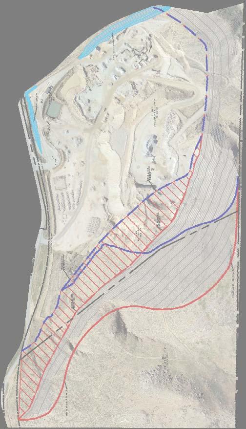
59 47


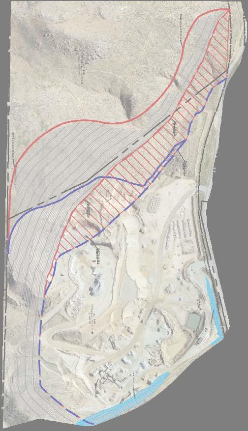
60 48
61 49
62 Amendment No. 2 to Reclamation Plan Traffic Impact Analysis Based on a comparison of Existing traffic volumes to the Horizon Year (2035) forecasts, the average growth rate is estimated at approximately percent compounded annually between Existing and Horizon Year (2035) traffic conditions. The annual growth rate at each individual intersection is not lower than 9.12 percent compounded annually to as high as percent compounded annually over the same time period. Therefore, the annual growth rate utilized for the purposes of this analysis would appear to conservatively approximate the anticipated regional growth in traffic volumes in the City of Lake Elsinore for both EAPC and Horizon Year (2035) traffic conditions, especially when considered along with the addition of project-related traffic. As such, the growth in traffic volumes assumed in this TIA would tend to overstate as opposed to understate the potential deficiencies to traffic and circulation. 4.6 CUMULATIVE DEVELOPMENT TRAFFIC California Environmental Quality Act (CEQA) guidelines require that other reasonably foreseeable development projects which are either approved or being processed concurrently in the study area also be included as part of a cumulative analysis scenario. A cumulative project list was developed for the purposes of this analysis through consultation with planning and engineering staff from the City of Lake Elsinore, the cumulative project list includes known and foreseeable projects that are anticipated to contribute traffic to the study area intersections. The cumulative projects provided by the City of Lake Elsinore are provided in Appendix 4.1. In addition, the County of Riverside was also contacted to obtain near-by cumulative projects that could potentially contribute traffic at the study area intersections. Where applicable, cumulative projects anticipated to contribute measurable traffic (i.e. 50 or more peak hour trips) to study area intersections have been manually added to the study area network to generate EAPC forecasts. In other words, this list of cumulative development projects has been reviewed to determine which projects would likely contribute measurable traffic through the study area intersections (e.g., those cumulative projects in close proximity to the proposed Project). For the purposes of this analysis, the cumulative projects that were determined to affect one or more of the study area intersections are shown on Exhibit 4-4 and listed on Table 4-6. Any other cumulative projects that are not expected to contribute measurable traffic to study area intersections have not been included since the traffic would dissipate due to the distance from the Project site and study area intersections. Any additional traffic generated by other projects not on the cumulative projects list is accounted for through background ambient growth factors that have been applied to the peak hour volumes at study area intersections as discussed in Section 4.5 Background Traffic. 4.7 NEAR-TERM TRAFFIC FORECASTS To provide a comprehensive assessment of potential transportation network deficiencies, two types of analyses, buildup and buildout, were performed in support of this work effort. The buildup method was used to approximate the EAP traffic forecasts includes background traffic, and is intended to identify the peak hour LOS deficiencies on both the existing and planned near-term circulation system. The buildup method was also utilized to approximate TIA Report REV.docx 50 50
63 Amendment No. 2 to Reclamation Plan Traffic Impact Analysis EXHIBIT 4-4: CUMULATIVE DEVELOPMENT PROJECTS LOCATION MAP LE21!LE25 LE26!LE22 SITE!LE27 LE28 LE20 LE24 LE29 LAKE ELSINORE RC2 RC4 LE3 RC3 LE37 LE23 RC1 LE4 LE5 LE2 LE7 LE6 LE8 LE9 LE1 CANYON LAKE LE36 LE35 LE10 LE12 LE19 LE30 LE31 LE11 LE13 LE14 LE15!LE18 LE32 LE16 LE33 LE34 LE17 WILDOMAR W5 W7 W6 W2 W1! W4 W3 Sources: Esri, HERE, DeLorme, TomTom, Intermap, increment P Corp., GEBCO, USGS, FAO, NPS, NRCAN, GeoBase, IGN, Kadaster NL, Ordnance Survey, Esri Japan, METI, Esri China (Hong Kong), swisstopo, MapmyIndia, OpenStreetMap contributors, and the GIS User Community _N CD_letter.mxd 51
64 Table 4-6 (Page 1 of 3) Summary of Cumulative Development Projects No. Project Name Location Land Use Quantity 1 City of Lake Elsinore LE1 Greenwald 2 Lake Elsinore Shopping Center TSF LE2 Ramsgate Lake Elsinore Single Family Residential 1,012 DU Condo/Townhomes 120 DU LE3 Trieste Residential (Tract 36624) Lake Elsinore Single Family Residential 75 DU LE4 LE Minthorn Street 3 Lake Elsinore Single Family Residential 84 DU Single Family Residential 523 DU LE6 Spyglass Ranch 4 Lake Elsinore Condo/Townhomes 171 DU Shopping Center TSF LE7 South Shore I (Tract 31593) 5 Lake Elsinore Single Family Residential 521 DU South Shore II (Tract 36567) 5 Lake Elsinore Single Family Residential 147 DU LE8 La Strada (Tract 32077) Lake Elsinore Single Family Residential 134 DU LE9 Tuscany West (Tract 25473) 5 Lake Elsinore Single Family Residential 164 DU LE10 Marina Village Condos (Tract 33820) 6 Lake Elsinore Condo/Townhomes 94 DU Single Family Residential 170 DU Condo/Townhomes 250 DU Apartments 110 DU LE11 Watersedge5 Lake Elsinore Office TSF Hotel 150 RM Boat/Watercraft Dealers & Service TSF Mini Warehouse (Boat & Watercraft Stora TSF Shopping Center TSF Cottages by the Lake Lake Elsinore Condo/Townhomes 169 DU LE12 Tessera 5 Lake Elsinore Single Family Residential 90 DU LE13 TAG Property 6 Lake Elsinore New Car Sales TSF LE14 City Center Condos 6 Lake Elsinore Condo/Townhomes 144 DU LE15 Lake View Villas Lake Elsinore Condo/Townhomes 155 DU Condo/Townhomes 600 DU LE16 Diamond Specific Plan 7 Lake Elsinore Hotel 150 RM General Office TSF Shopping Center TSF The Colony 6 Lake Elsinore Apartments 211 DU Back Basin Specific Plan & East Lake Single Family Residential 2,407 DU Lake Elsinore Specific Plan Condo/Townhomes 324 DU LE17 Single Family Residential 506 DU John Laing Homes (Phase 2) Lake Elsinore Condo/Townhomes 1,141 DU Apartments 308 DU Shopping Center TSF Canyon Hills Estates (Tract 34249) Lake Elsinore Single Family Residential 302 DU Single Family Residential 2,700 DU Canyon Hills (Multiple Tracts) Lake Elsinore LE18 Apartments 1,575 DU Audie Murphy (Tract 36484) Lake Elsinore Single Family Residential 109 DU Audie Murphy (Tract 36485) Lake Elsinore Single Family Residential 1,003 DU 52
65 Table 4-6 (Page 2 of 3) Summary of Cumulative Development Projects No. Project Name Location Land Use Quantity 1 LE19 Gruneto Hills Lake Elsinore Single Family Residential 191 DU LE20 Hotel at Lawrence Way Lake Elsinore Hotel 57 RM Single Family Residential 1,056 DU LE21 Alberhill Ridge (Tract 35001) Lake Elsinore Apartments 345 DU Shopping Center TSF General Office TSF LE22 Alberhill Ranch Lake Elsinore Single Family Residential 1,986 DU Free Standing Discount Superstore TSF LE23 Lake Elsinore Walmart Lake Elsinore Specialty Retail TSF Fast Food w/drive Thru TSF Fast Food w/o Drive Thru TSF LE24 Circle K Lake Elsinore Gas Station TSF LE25 Alberhill Villages Lake Elsinore Single Family Residential 9,536 DU LE26 Terracina Lake Elsinore Single Family Residential 365 DU LE27 Encore at Cambria Hills Lake Elsinore Single Family Residential 214 DU LE28 Family Dollar Store Lake Elsinore Discount Store TSF LE29 Fisherman's Wharf Lake Elsinore Fisherman's Wharf TSF LE30 Wake Rider Beach Resort Lake Elsinore Beach Resort TSF LE31 Lakeshore Town Center Lake Elsinore Town Center TSF LE32 Ortega Lake Elsinore Single Family Residential 105 DU LE33 Summerly Lake Elsinore Single Family Residential 142 DU LE34 Beazer, KB Homes, McMillin Homes, Richmond American Lake Elsinore Single Family Residential 395 DU LE35 Village at Lake Elsinore SPA #1 Lake Elsinore Single Family Residential 163 DU LE36 Lake Shore Pointe Phase I Lake Elsinore Single Family Residential 43 DU Apartments 161 DU LE37 Golden Corral Restaurant Lake Elsinore Restaurant TSF County of Riverside RC1 Lennar (Tract 31792) County of Riverside Single Family Residential 191 DU RC2 PM33840 County of Riverside Single Family Residential 4 DU RC3 PP20158R1 County of Riverside Storage Facility TSF RC4 CUP03651 County of Riverside Recycling Facility TSF City of Wildomar Rancon Monte Vista Residential (TTM W1 No , APN: , Wildomar SFDR 126 DU 008) Free Standing Discount Superstore TSF W2 Wildomar Walmart Wildomar Specialty Retail TSF Fast food with Drive Through TSF W3 Cornerstone Church Pre School Expansion (PUP No. 778) 4 Wildomar Pre School/Day Care 180 STU W4 Sehremelis PAR (TTM 29426, APN: ) Lake Elsinore SFDR 80 DU W5 Subway (Case No , APN: , ) Wildomar Specialty Retail TSF 53
66 Table 4-6 (Page 3 of 3) Summary of Cumulative Development Projects No. Project Name Location Land Use W6 Orange Bundy (TPM 30522, APN: 367 Retail Wildomar Fast Food w/drive Thru , ) Gas Station w/ Market W7 Bundy Canyon Plaza (Case No , Retail Wildomar Fast Food w/drive Thru TPM 32257, APN: ) Gas Station w/ Market 1 TSF = Thousand Square Feet; DU = Dwelling Unit; AC = Acres; STU = Students; VFP = Vehicle Fueling Positions 2 Source: Greenwald Avenue Commercial Center TIA, Urban Crossroads, Inc., May Source: 1400 Minthorn Street Traffic Study Report, ASM Consulting, August Source: Spyglass Ranch TIA (Revised), Kunzman Associates, February Source: Porto Romano SP TIA (Revised), Urban Crossroads, Inc., May Source: Lake Elsinore TAG Property TIA (Revised), Urban Crossroads, Inc., August Source: The Diamond Specific Plan TIA, Urban Crossroads, Inc., April Quantity TSF TSF 6 VFP TSF TSF 12 VFP 54
67 Amendment No. 2 to Reclamation Plan Traffic Impact Analysis the EAPC traffic forecasts, and is intended to identify the LOS deficiencies on both the existing and planned near-term circulation system. The EAPC traffic forecasts include background traffic, traffic generated by other cumulative development projects within the study area, and the traffic generated by the proposed Project. The buildout approach is used to forecast the Horizon Year Without and With Project conditions of the study area. The buildup approach combines existing traffic counts with a background ambient growth factor to forecast the near-term 2016 traffic conditions. An ambient growth factor of 2% (2016) accounts for background (area-wide) traffic increases that occur over time, up to the year 2016 from the year 2015 (two percent per year growth over a one year period). Traffic volumes generated by the Project are then added to assess the EAP and EAPC traffic conditions. The 2016 roadway network is similar to consistent with the existing conditions roadway network with the exception of future roadways and intersections proposed to be developed by the Project. As noted previously, an analysis of the proposed Project at various development tiers has been assessed for the purposes of this traffic study. The near-term traffic analysis includes the following traffic conditions, with the various traffic components: EAP (2016) o Existing 2015 counts o Ambient growth traffic (2%) o Project traffic EAPC (2016) o Existing 2015 counts o Ambient growth traffic (2%) o Cumulative Development Project traffic o Project traffic 4.8 HORIZON YEAR (2035) VOLUME DEVELOPMENT The Horizon Year (2035) With Project traffic conditions were derived from the Riverside County Transportation Analysis Model (RivTAM) using accepted procedures for model forecast refinement and smoothing. The traffic forecasts reflect the area-wide growth anticipated between Existing conditions and Horizon Year conditions. In most instances the traffic model zone structure is not designed to provide accurate turning movements along arterial roadways unless refinement and reasonableness checking is performed. Therefore, the Horizon Year With Project peak hour forecasts were refined using the model derived long-range forecasts, along with existing peak hour traffic count data collected at each analysis location in May Future estimated peak hour traffic data was used for new intersections and intersections with an anticipated change in travel patterns to further refine the Horizon Year With Project peak hour forecasts TIA Report REV.docx 55 55
68 Amendment No. 2 to Reclamation Plan Traffic Impact Analysis The refined future peak hour approach and departure volumes obtained from the model output data are then entered into a spreadsheet program consistent with the National Cooperative Highway Research Program (NCHRP Report 255), along with initial estimates of turning movement proportions. A linear programming algorithm is used to calculate individual turning movements which match the known directional roadway segment forecast volumes computed in the previous step. This program computes a likely set of intersection turning movements from intersection approach counts and the initial turning proportions from each approach leg. Typically, the model growth is prorated and is subsequently added to the existing (base validation) traffic volumes to represent Long Range traffic conditions. However, review of the resulting model growth indicates negative growth for several study area intersections. In an effort to conduct a conservative analysis, reductions to traffic forecasts from either Existing or EAPC traffic conditions were not assumed as part of this analysis. As such, in conjunction with the addition of cumulative projects that are not consistent with the General Plan, additional growth has also been applied on a movement-by-movement basis, where applicable, to estimate reasonable Horizon Year forecasts. Horizon Year turning volumes were compared to EAPC volumes in order to ensure a minimum growth as a part of the refinement process. The minimum growth includes any additional growth between EAPC and Horizon Year traffic conditions that is not accounted for by the traffic generated by cumulative development projects and ambient growth rates assumed between Existing (2015) and EAPC traffic conditions. Future estimated peak hour traffic data was used for new intersections and intersections with an anticipated change in travel patterns to further refine the Horizon Year peak hour forecasts. The future Horizon Year without Project peak hour turning movements were then reviewed by Urban Crossroads for reasonableness, and in some cases, were adjusted to achieve flow conservation, reasonable growth, and reasonable diversion between parallel routes. Flow conservation checks ensure that traffic flow between two closely spaced intersections, such as two freeway ramp locations, is verified in order to make certain that vehicles leaving one intersection are entering the adjacent intersection and that there are no unexplained loss of vehicles. The result of this traffic forecasting procedure is a series of traffic volumes which are suitable for traffic operations analysis. The truck component of RivTAM has data that is unusually low. As such, in an effort to conduct a conservative analysis, the presence of trucks has been accounted for based on the manual volume adjustments made to demonstrate growth above EAPC traffic forecasts, which are presented and evaluated in PCE (see Section 3.5 Existing (2015) Traffic Counts for discussion on PCE). As such, the Horizon Year forecasts are also assumed to be in PCE for the purposes of this analysis. Post-processing worksheets for Horizon Year Without Project traffic conditions are provided in Appendix TIA Report REV.docx 56 56
69 Amendment No. 2 to Reclamation Plan Traffic Impact Analysis 5 E+P TRAFFIC CONDITIONS This section discusses the traffic forecasts for Existing plus Project (E+P) conditions and the resulting intersection operations, traffic signal warrant, and freeway mainline operations analyses. 5.1 ROADWAY IMPROVEMENTS The lane configurations and traffic controls assumed to be in place for E+P conditions are consistent with those shown previously on Exhibit EXISTING PLUS PROJECT TRAFFIC VOLUME FORECASTS This scenario includes Existing traffic volumes plus Project traffic. Exhibit 5-1 shows the ADT and peak hour intersection turning movement volumes, which can be expected for E+P traffic conditions. 5.3 INTERSECTION OPERATIONS ANALYSIS E+P peak hour traffic operations have been evaluated, for each phase of development, for the study area intersections based on the analysis methodologies presented in Section 2 Methodologies of this TIA. The intersection analysis results are summarized in Table 5-1, which indicates that the study area intersections are anticipated to continue to operate at acceptable LOS under E+P traffic conditions, consistent with Existing traffic conditions. A summary of the peak hour intersection LOS for E+P conditions are shown on Exhibit 5-2. The intersection operations analysis worksheets for E+P traffic conditions are included in Appendix 5.1 of this TIA. 5.4 OFF-RAMP QUEUING ANALYSIS A queuing analysis was performed for the off-ramps at the I-15 Freeway and Nichols Road interchange to assess vehicle queues for the off ramps that may potentially result in deficient peak hour operations at the ramp-to-arterial intersections and may potentially spill back onto the I-15 Freeway mainline. Queuing analysis findings are presented in Table 5-2 for E+P traffic conditions. It is important to note that off-ramp lengths are consistent with the measured distance between the intersection and the freeway mainline. As shown on Table 5-2, there are no movements that are anticipated to experience queuing issues during the weekday AM or weekday PM peak 95 th percentile traffic flows for E+P traffic conditions. Worksheets for E+P traffic conditions off-ramp queuing analysis are provided in Appendix 5.1 for E+P traffic conditions TIA Report REV.docx 57 57
70 58
71 59
72 Table 5 1 Intersection Analysis for E+P Conditions Existing (2015) Existing Plus Project Delay 1 Level of Delay 1 Level of Acceptable Traffic (secs.) Service (secs.) Service LOS # Intersection Control 2 AM PM AM PM AM PM AM PM 1 I 15 SB Ramps / Nichols Rd. AWS B B B B D 2 I 15 NB Ramps / Nichols Rd. CSS C C C C D 3 Dwy. 1 / Nichols Rd. CSS B A B A C 4 Dwy. 2 / Nichols Rd. CSS A A A A C 1 Per the 2010 Highway Capacity Manual, overall average intersection delay and level of service are shown for intersections with a traffic signal or all way stop control. For intersections with cross street stop control, the delay and level of service for the worst individual movement (or movements sharing a single lane) are shown. 2 CSS = Cross street Stop; AWS = All way Stop 60
73 Table 5 2 Peak Hour Freeway Off Ramp Queuing Summary for E+P Conditions Available Existing (2015) Existing plus Project Stacking 95th Percentile Queue 95th Percentile Queue Distance (Feet) 2 Acceptable? 1 (Feet) 2 Acceptable? 1 Intersection Movement (Feet) AM Peak PM Peak AM PM AM Peak PM Peak AM PM I 15 SB Off Ramp / Nichols Rd. SBL/T/R 1, Yes Yes Yes Yes I 15 NB Off Ramp / Nichols Rd. NBL/T/R 1, Yes Yes Yes Yes 1 Stacking Distance is acceptable if the required stacking distance is less than or equal to the stacking distance provided. An additional 15 feet of stacking which is assumed to be provided in the transition for turn pockets is reflected in the stacking distance shown on this table, where applicable. 2 Maximum queue length for the approach reported. 61
74 Amendment No. 2 to Reclamation Plan Traffic Impact Analysis 5.5 TRAFFIC SIGNAL WARRANTS ANALYSIS There are no intersections anticipated to meet traffic signal warrants for E+P traffic conditions (see Appendix 5.2). 5.6 BASIC FREEWAY SEGMENT ANALYSIS E+P mainline directional volumes for the weekday AM and PM peak hours are provided on Exhibits 5-3. As shown on Table 5-3, the basic freeway segments analyzed for this study are anticipated to operate at an acceptable LOS during the peak hours, with the addition of Project traffic. E+P basic freeway segment analysis worksheets are provided in Appendix FREEWAY MERGE/DIVERGE ANALYSIS Ramp merge and diverge operations were also evaluated for E+P traffic conditions and the results of this analysis are presented in Table 5-4. As shown in Table 5-4, the freeway ramp merge and diverge areas are anticipated to operate at LOS D or better. E+P freeway ramp junction operations analysis worksheets are provided in Appendix TIA Report REV.docx 62 62
75 63
76 Table 5 3 Basic Freeway Segment Analysis for E+P Conditions Existing (2015) Existing plus Project Freeway Direction Mainline Segment Lanes 1 Density 2 LOS Density2 LOS AM PM AM PM AM PM AM PM I 15 Freeway SB NB North of Nichols Road B C B C South of Nichols Road B C B C North of Nichols Road C B C B South of Nichols Road C B C B 1 Number of lanes are in the specified direction and is based on existing conditions. 2 Density is measured by passenger cars per mile per lane (pc/mi/ln). 64
77 Table 5 4 Freeway Ramp Junction Merge/Diverge Analysis for E+P Conditions Ramp or Segment Lanes on Freeway 1 Existing (2015) Existing Plus Project AM Peak Hour PM Peak Hour AM Peak Hour PM Peak Hour Density 2 LOS Density 2 LOS Density 2 LOS Density 2 LOS 1 2 Off Ramp at Nichols Road C 28.3 D 21.1 C 28.3 D On Ramp at Nichols Road B 26.3 C 19.6 B 26.4 C On Ramp at Nichols Road B 17.6 B 18.7 B 17.7 B Off Ramp at Nichols Road C 24.2 C 24.6 C 24.2 C I 15 Freeway NB SB Freeway Direction Number of lanes are in the specified direction and is based on existing conditions. Density is measured by passenger cars per mile per lane (pc/mi/ln). 65
78 Amendment No. 2 to Reclamation Plan Traffic Impact Analysis This Page Intentionally Left Blank TIA Report REV.docx 66 66
79 Amendment No. 2 to Reclamation Plan Traffic Impact Analysis 6 EAP (2016) TRAFFIC CONDITIONS This section discusses the methods used to develop Existing plus Ambient Growth plus Project (EAP) (2016) traffic forecasts, and the resulting intersection operations, traffic signal warrant, and freeway mainline operations analyses. 6.1 ROADWAY IMPROVEMENTS The lane configurations and traffic controls assumed to be in place for EAP conditions are consistent with those shown previously on Exhibit EAP (2016) TRAFFIC VOLUME FORECASTS To account for background traffic growth, an ambient growth from Existing conditions of 2% (2 percent per year over 1 year) is included for EAP traffic conditions. Cumulative development projects are not included as part of the EAP analysis. The weekday ADT and weekday AM and PM peak hour volumes which can be expected for EAP traffic conditions are shown on Exhibit INTERSECTION OPERATIONS ANALYSIS LOS calculations were conducted for the study intersections to evaluate their operations under EAP conditions with roadway and intersection geometrics consistent with Section 6.1 Roadway Improvements. As shown in Table 6-1, the study area intersections are anticipated to operate at acceptable LOS under EAP traffic conditions, consistent with Existing traffic conditions. A summary of the peak hour intersection LOS for EAP traffic conditions are shown on Exhibit 6-2. The intersection operations analysis worksheets for EAP traffic conditions are included in Appendix 6.1 of this TIA. 6.4 OFF-RAMP QUEUING ANALYSIS A queuing analysis was performed for the off-ramps at the I-15 Freeway and Nichols Road interchange to assess vehicle queues for the off ramps that may potentially result in deficient peak hour operations at the ramp-to-arterial intersections and may potentially spill back onto the I-15 Freeway mainline. Queuing analysis findings are presented in Table 6-2 for EAP traffic conditions. It is important to note that off-ramp lengths are consistent with the measured distance between the intersection and the freeway mainline. As shown on Table 6-2, there are no movements that are anticipated to experience queuing issues during the weekday AM or weekday PM peak 95 th percentile traffic flows for EAP traffic conditions. Worksheets for EAP conditions off-ramp queuing analysis are provided in Appendix TIA Report REV.docx 67 67
80 68
81 69
82 Table 6 1 Intersection Analysis for EAP (2016) Conditions Existing (2015) EAP (2016) Delay 1 Level of Delay 1 Level of Acceptable Traffic (secs.) Service (secs.) Service LOS # Intersection Control 2 AM PM AM PM AM PM AM PM 1 I 15 SB Ramps / Nichols Rd. AWS B B B B D 2 I 15 NB Ramps / Nichols Rd. CSS C C C D D 3 Dwy. 1 / Nichols Rd. CSS B A B A C 4 Dwy. 2 / Nichols Rd. CSS A A A A C 1 Per the 2010 Highway Capacity Manual, overall average intersection delay and level of service are shown for intersections with a traffic signal or all way stop control. For intersections with cross street stop control, the delay and level of service for the worst individual movement (or movements sharing a single lane) are shown. 2 CSS = Cross street Stop; AWS = All way Stop 70
83 Table 6 2 Peak Hour Freeway Off Ramp Queuing Summary for EAP (2016) Conditions Available Stacking Distance Existing (2015) EAP (2016) 95th Percentile Queue 95th Percentile Queue (Feet) 2 Acceptable? 1 (Feet) 2 Acceptable? 1 AM Peak PM Peak AM Peak PM Peak Intersection Movement (Feet) AM PM AM PM I 15 SB Off Ramp / Nichols Rd. SBL/T/R 1, Yes Yes Yes Yes I 15 NB Off Ramp / Nichols Rd. NBL/T/R 1, Yes Yes Yes Yes 1 Stacking Distance is acceptable if the required stacking distance is less than or equal to the stacking distance provided. An additional 15 feet of stacking which is assumed to be provided in the transition for turn pockets is reflected in the stacking distance shown on this table, where applicable. 2 Maximum queue length for the approach reported. 71
84 Amendment No. 2 to Reclamation Plan Traffic Impact Analysis 6.5 TRAFFIC SIGNAL WARRANTS ANALYSIS No study area intersections are anticipated to meet traffic signal warrants for EAP traffic conditions (see Appendix 6.2). 6.6 BASIC FREEWAY SEGMENT ANALYSIS EAP mainline directional volumes for the weekday AM and PM peak hours are provided on Exhibit 6-3. As shown on Table 6-3, the freeway segments analyzed for this study are anticipated to operate at an acceptable LOS during the peak hours. EAP basic freeway segment analysis worksheets are provided in Appendix FREEWAY MERGE/DIVERGE ANALYSIS Ramp merge and diverge operations were also evaluated for EAP conditions and the results of this analysis are presented in Table 6-4. As shown in Table 6-4, the freeway ramp merge and diverge areas are anticipated to operate at LOS D or better. EAP freeway ramp junction operations analysis worksheets are provided in Appendix TIA Report REV.docx 72 72
85 73
86 Table 6 3 Basic Freeway Segment Analysis for EAP (2016) Conditions Existing (2015) EAP (2016) Freeway Direction Mainline Segment Lanes 1 Density 2 LOS Density 2 LOS AM PM AM PM AM PM AM PM I 15 Freeway SB NB North of Nichols Road B C B C South of Nichols Road B C B C North of Nichols Road C B C B South of Nichols Road C B C B 1 Number of lanes are in the specified direction and is based on existing conditions. 2 Density is measured by passenger cars per mile per lane (pc/mi/ln). 74
87 Table 6 4 Freeway Ramp Junction Merge/Diverge Analysis for EAP (2016) Conditions Ramp or Segment Lanes on Freeway 1 Existing (2015) EAP (2016) AM Peak Hour PM Peak Hour AM Peak Hour PM Peak Hour Freeway Density 2 LOS Density 2 LOS Density 2 LOS Density 2 LOS Direction 1 2 Off Ramp at Nichols Road C 28.3 D 21.5 C 28.7 D On Ramp at Nichols Road B 26.3 C 19.9 B 26.8 C On Ramp at Nichols Road B 17.6 B 19.1 B 18.0 B Off Ramp at Nichols Road C 24.2 C 25.0 C 24.6 C I 15 Freeway NB SB Number of lanes are in the specified direction and is based on existing conditions. Density is measured by passenger cars per mile per lane (pc/mi/ln). 75
88 Amendment No. 2 to Reclamation Plan Traffic Impact Analysis This Page Intentionally Left Blank TIA Report REV.docx 76 76
89 Amendment No. 2 to Reclamation Plan Traffic Impact Analysis 7 EAPC (2016) TRAFFIC CONDITIONS This section discusses the methods used to develop Existing plus Ambient Growth plus Project plus Cumulative (EAPC) (2016) traffic forecasts, and the resulting intersection operations, traffic signal warrant, and freeway mainline operations analyses. 7.1 ROADWAY IMPROVEMENTS The lane configurations and traffic controls assumed to be in place for EAPC (2016) conditions are consistent with those shown previously on Exhibit EAPC (2016) TRAFFIC VOLUME FORECASTS To account for background traffic, other known cumulative development projects in the study area were included in addition to 2% of ambient growth for EAPC traffic conditions in conjunction with traffic associated with the proposed Project. The weekday ADT and weekday AM and PM peak hour volumes which can be expected for EAPC (2016) traffic conditions are shown on Exhibit INTERSECTION OPERATIONS ANALYSIS LOS calculations were conducted for the study intersections to evaluate their operations under EAPC conditions with roadway and intersection geometrics consistent with Section 7.1 Roadway Improvements. As shown in Table 7-1, the study area intersections are anticipated to operate at acceptable levels of service, with the exception of the following locations: ID Intersection Location 1 I-15 Southbound Ramps / Nichols Road LOS F AM and PM peak hours 2 I-15 Northbound Ramps / Nichols Road LOS F AM peak hour; LOS E and PM peak hours A summary of the peak hour intersection LOS for EAPC conditions are shown on Exhibit 7-2. The intersection operations analysis worksheets for EAPC traffic conditions are included in Appendix 7.1 of this TIA. Measures to address near-term cumulative deficiencies for EAPC traffic conditions are discussed in Section 7.8 EAPC Deficiencies and Recommended Improvements. 7.4 OFF-RAMP QUEUING ANALYSIS A queuing analysis was performed for the off-ramps at the I-15 Freeway and Nichols Road interchange to assess vehicle queues for the off ramps that may potentially result in deficient peak hour operations at the ramp-to-arterial intersections and may potentially spill back onto the I-15 Freeway mainline. Queuing analysis findings are presented in Table 7-2 for EAPC traffic conditions. It is important to note that off-ramp lengths are consistent with the measured distance between the intersection and the freeway mainline. As shown on Table 7-2, there are no movements that are anticipated to experience queuing issues during the weekday AM or weekday PM peak 95 th percentile traffic flows for EAPC traffic conditions TIA Report REV.docx 77 77
90 78
91 79
92 Table 7 1 Intersection Analysis for EAPC (2016) Conditions Existing (2015) EAPC (2016) Delay 1 Level of Delay 1 Level of Acceptable Traffic (secs.) Service (secs.) Service LOS # Intersection Control 2 AM PM AM PM AM PM AM PM 1 I 15 SB Ramps / Nichols Rd. AWS B B F F D 2 I 15 NB Ramps / Nichols Rd. CSS C C >100.0 >100.0 F F D 3 Dwy. 1 / Nichols Rd. CSS B A C B C 4 Dwy. 2 / Nichols Rd. CSS A A A A C * BOLD = LOS does not meet the applicable jurisdictional requirements (i.e., unacceptable LOS). 1 Per the 2010 Highway Capacity Manual, overall average intersection delay and level of service are shown for intersections with a traffic signal or all way stop control. For intersections with cross street stop control, the delay and level of service for the worst individual movement (or movements sharing a single lane) are shown. 2 CSS = Cross street Stop; AWS = All way Stop 80
93 Table 7 2 Peak Hour Freeway Off Ramp Queuing Summary for EAPC (2016) Conditions Available Stacking Distance Existing (2015) EAPC (2016) 95th Percentile Queue 95th Percentile Queue (Feet) 2 Acceptable? 1 (Feet) 2 Acceptable? 1 AM Peak PM Peak AM Peak PM Peak Intersection Movement (Feet) AM PM AM PM I 15 SB Off Ramp / Nichols Rd. SBL/T/R 1, Yes Yes Yes Yes I 15 NB Off Ramp / Nichols Rd. NBL/T/R 1, Yes Yes 1,028 1,173 Yes Yes 1 Stacking Distance is acceptable if the required stacking distance is less than or equal to the stacking distance provided. An additional 15 feet of stacking which is assumed to be provided in the transition for turn pockets is reflected in the stacking distance shown on this table, where applicable. 2 Maximum queue length for the approach reported. 3 95th percentile volume exceeds capacity, queue may be longer. Queue shown is maximum after two cycles. 81
94 Amendment No. 2 to Reclamation Plan Traffic Impact Analysis Worksheets for EAPC conditions off-ramp queuing analysis are provided in Appendix TRAFFIC SIGNAL WARRANTS ANALYSIS The following study area intersections are anticipated to warrant a traffic signal for EAPC traffic conditions (see Appendix 7.2): ID 1 I-15 Southbound Ramps / Nichols Road 2 I-15 Northbound Ramps / Nichols Road Intersection Location 7.6 BASIC FREEWAY SEGMENT ANALYSIS EAPC mainline directional volumes for the weekday AM and PM peak hours are provided on Exhibit 7-3. As shown on Table 7-3, the freeway segments analyzed for this study are anticipated to operate at an acceptable LOS (i.e., LOS D or better) during the peak hours. EAPC basic freeway segment analysis worksheets are provided in Appendix FREEWAY MERGE/DIVERGE ANALYSIS Ramp merge and diverge operations were also evaluated for EAPC conditions and the results of this analysis are presented in Table 7-4. As shown in Table 7-4, the freeway ramp merge and diverge areas are anticipated to operate at LOS D or better. EAPC freeway ramp junction operations analysis worksheets are provided in Appendix EAPC DEFICIENCIES AND RECOMMENDED IMPROVEMENTS Improvement strategies have been recommended at intersections that have been identified as deficient in an effort to reduce each location s peak hour delay and improve the associated LOS grade to an acceptable LOS (LOS D or better). The effectiveness of the recommended improvement strategies discussed below to address EAPC traffic deficiencies is presented in Table 7-5. Worksheets for EAPC conditions, with improvements, HCM calculation worksheets are provided in Appendix TIA Report REV.docx 82 82
95 Table 7 3 Basic Freeway Segment Analysis for EAPC (2016) Conditions Existing (2015) EAPC (2016) Freeway Direction Mainline Segment Lanes 1 Density 2 LOS Density 2 LOS AM PM AM PM AM PM AM PM I 15 Freeway SB NB North of Nichols Road B C B C South of Nichols Road B C B D North of Nichols Road C B D D South of Nichols Road C B D D 1 Number of lanes are in the specified direction and is based on existing conditions. 2 Density is measured by passenger cars per mile per lane (pc/mi/ln). 83
96 Table 7 4 Freeway Ramp Junction Merge/Diverge Analysis for EAPC (2016) Conditions Ramp or Segment Lanes on Freeway 1 Existing (2015) EAPC (2016) AM Peak Hour PM Peak Hour AM Peak Hour PM Peak Hour Freeway Density 2 LOS Density 2 LOS Density 2 LOS Density 2 LOS Direction 1 2 Off Ramp at Nichols Road C 28.3 D 23.4 C 30.7 D On Ramp at Nichols Road B 26.3 C 22.4 C 29.8 D On Ramp at Nichols Road B 17.6 B 26.9 C 27.8 C Off Ramp at Nichols Road C 24.2 C 32.7 D 34.1 D I 15 Freeway NB SB Number of lanes are in the specified direction and is based on existing conditions. Density is measured by passenger cars per mile per lane (pc/mi/ln). 84
97 85
98 Table 7 5 Intersection Analysis for EAPC (2016) Conditions With Improvements Intersection Approach Lanes 1 Delay 2 Level of Traffic Northbound Southbound Eastbound Westbound (secs.) Service # Intersection Control 3 L T R L T R L T R L T R AM PM AM PM 1 I 15 SB Ramps / Nichols Rd. Without Improvements AWS F F With Improvements TS D D 2 I 15 NB Ramps / Nichols Rd. Without Improvements CSS >100.0 >100.0 F F With Improvements TS D D * BOLD = LOS does not meet the applicable jurisdictional requirements (i.e., unacceptable LOS). 1 When a right turn is designated, the lane can either be striped or unstriped. To function as a right turn lane there must be sufficient width for right turning vehicles to travel outside the through lanes. L = Left; T = Through; R = Right; d = Defacto Right Turn Lane; 1 = Improvement 2 3 Per the 2010 Highway Capacity Manual, overall average intersection delay and level of service are shown for intersections with a traffic signal or all way stop control. For intersections with cross street stop control, the delay and level of service for the worst individual movement (or movements sharing a single lane) are shown. AWS = All Way Stop; TS = Traffic Signal 86
99 Amendment No. 2 to Reclamation Plan Traffic Impact Analysis 8 HORIZON YEAR (2035) TRAFFIC CONDITIONS This section discusses the methods used to develop Horizon Year (2035) Without and With Project traffic forecasts, and the resulting intersection operations, traffic signal warrant, and freeway mainline operations analyses. 8.1 ROADWAY IMPROVEMENTS The lane configurations and traffic controls assumed to be in place for Horizon Year conditions are consistent with those shown previously on Exhibit 3-1, with the exception of the following: Other parallel facilities, that although not evaluated for the purposes of this analysis, are anticipated to be in place for Horizon Year traffic conditions and would affect the travel patterns within the study. 8.2 HORIZON YEAR (2035) WITHOUT PROJECT TRAFFIC VOLUME FORECASTS This scenario includes the refined post-processed volumes obtained from the RivTAM. For additional information on the development of the Horizon Year Without Project traffic forecasts, see Section 4.8 Horizon Year (2035) Volume Development of this TIA. The weekday ADT and weekday AM and PM peak hour volumes which can be expected for Horizon Year Without Project traffic conditions are shown on Exhibit HORIZON YEAR (2035) WITH PROJECT TRAFFIC VOLUME FORECASTS This scenario includes the refined post-processed volumes obtained from the RivTAM, plus Project traffic. The weekday ADT and weekday AM and PM peak hour volumes which can be expected for Horizon Year With Project traffic conditions are shown on Exhibit INTERSECTION OPERATIONS ANALYSIS HORIZON YEAR WITHOUT PROJECT TRAFFIC CONDITIONS LOS calculations were conducted for the study intersections to evaluate their operations under Horizon Year Without Project conditions with roadway and intersection geometrics consistent with Section 8.1 Roadway Improvements. As shown in Table 8-1, there were no additional intersections found to operate at a deficient LOS, in addition to those previously identified under EAPC traffic conditions. A summary of the peak hour intersection LOS for Horizon Year Without Project conditions are shown on Exhibit 8-3. The intersection operations analysis worksheets for Horizon Year Without Project traffic conditions are included in Appendix 8.1 of this TIA TIA Report REV.docx 87 87
100 88
101 89
102 90
103 Table 8 1 Intersection Analysis for Horizon Year (2035) Conditions 2035 Without Project 2035 With Project Delay 1 Level of Delay 1 Level of Acceptable Traffic (secs.) Service (secs.) Service LOS # Intersection Control 2 AM PM AM PM AM PM AM PM 1 I 15 SB Ramps / Nichols Rd. AWS F F F F D 2 I 15 NB Ramps / Nichols Rd. CSS >100.0 >100.0 F F >100.0 >100.0 F F D 3 Dwy. 1 / Nichols Rd. CSS C C C C C 4 Dwy. 2 / Nichols Rd. CSS C C C C C * BOLD = LOS does not meet the applicable jurisdictional requirements (i.e., unacceptable LOS). 1 Per the 2010 Highway Capacity Manual, overall average intersection delay and level of service are shown for intersections with a traffic signal or all way stop control. For intersections with cross street stop control, the delay and level of service for the worst individual movement (or movements sharing a single lane) are shown. 2 CSS = Cross street Stop; AWS = All way Stop 91
104 Amendment No. 2 to Reclamation Plan Traffic Impact Analysis HORIZON YEAR WITH PROJECT TRAFFIC CONDITIONS As shown on Table 8-1 and illustrated on Exhibit 8-4, there are no additional study area intersections anticipated to experience unacceptable LOS (LOS E or worse) with the addition of Project traffic during one or more peak hours in addition to those previously identified under Horizon Year Without Project conditions. The intersection operations analysis worksheets for Horizon Year With Project traffic conditions are included in Appendix 8.2 of this TIA. Measures to address long range deficiencies for Long Range traffic conditions are discussed in Section 8.9 Horizon Year Deficiencies and Recommended Improvements. 8.5 OFF-RAMP QUEUING ANALYSIS HORIZON YEAR WITHOUT PROJECT TRAFFIC CONDITIONS A queuing analysis was performed for the off-ramps at the I-15 Freeway and Nichols Road interchange to assess vehicle queues for the off ramps that may potentially result in deficient peak hour operations at the ramp-to-arterial intersections and may potentially spill back onto the I-15 Freeway mainline. Queuing analysis findings are presented in Table 8-2 for Horizon Year Without Project traffic conditions. It is important to note that off-ramp lengths are consistent with the measured distance between the intersection and the freeway mainline. As shown on Table 8-2, there I-15 Freeway and Nichols Road off-ramp is anticipated to experience queuing issues during the weekday peak 95 th percentile traffic flows for Horizon Year Without Project traffic conditions. Worksheets for Horizon Year Without Project conditions off-ramp queuing analysis are provided in Appendix HORIZON YEAR WITH PROJECT TRAFFIC CONDITIONS As shown on Table 8-2, there are no additional movements that are anticipated to experience queuing issues during the weekday AM or weekday PM peak 95 th percentile traffic flows for Horizon Year With Project traffic conditions in addition to those previously identified for Horizon Year Without Project traffic conditions. Worksheets for Horizon Year With Project conditions off-ramp queuing analysis are provided in Appendix TRAFFIC SIGNAL WARRANTS ANALYSIS No additional study area intersections are anticipated to meet traffic signal warrants for Horizon Year Without or With Project traffic conditions, in addition to those previously warranted under EAPC traffic conditions TIA Report REV.docx 92 92
105 93
106 Table 8 2 Peak Hour Freeway Off Ramp Queuing Summary for Horizon Year (2035) Conditions Available Stacking Distance 2035 Without Project 2035 With Project 95th Percentile Queue 95th Percentile Queue (Feet) 2 Acceptable? 1 (Feet) 2 Acceptable? 1 AM Peak PM Peak AM Peak PM Peak Intersection Movement (Feet) AM PM AM PM I 15 SB Off Ramp / Nichols Rd. SBL/T/R 1, Yes Yes Yes Yes I 15 NB Off Ramp / Nichols Rd. NBL/T/R 1,530 2,755 3,475 No No 2,838 3,520 No No 1 Stacking Distance is acceptable if the required stacking distance is less than or equal to the stacking distance provided. An additional 15 feet of stacking which is assumed to be provided in the transition for turn pockets is reflected in the stacking distance shown on this table, where applicable. 2 Maximum queue length for the approach reported. 94
107 Amendment No. 2 to Reclamation Plan Traffic Impact Analysis 8.7 BASIC FREEWAY SEGMENT ANALYSIS HORIZON YEAR WITHOUT PROJECT TRAFFIC CONDITIONS Horizon Year Without Project mainline directional volumes for the weekday AM and PM peak hours are provided on Exhibit 8-5. As shown on Table 8-3, all of the freeway segments analyzed for this study are anticipated to operate at an unacceptable LOS (i.e., LOS E or worse) during the peak hours. Horizon Year Without Project basic freeway segment analysis worksheets are provided in Appendix HORIZON YEAR WITH PROJECT TRAFFIC CONDITIONS Horizon Year With Project mainline directional volumes for the weekday AM and PM peak hours are provided on Exhibit 8-6. As shown on Table 8-3, there are no additional freeway segments anticipated to operate at an unacceptable LOS with the addition of Project traffic, in addition to those previously identified under Horizon Year Without Project conditions. Worksheets for Horizon Year With Project conditions basic freeway segment analysis worksheets are provided in Appendix FREEWAY MERGE/DIVERGE ANALYSIS HORIZON YEAR (2035) WITHOUT PROJECT TRAFFIC CONDITIONS Ramp merge and diverge operations were also evaluated for Horizon Year Without Project conditions and the results of this analysis are presented in Table 8-4. As shown in Table 8-4, all of the study area freeway merge and diverge ramp junctions are anticipated to operate at deficient LOS (i.e., LOS E or worse). Horizon Year Without Project freeway ramp junction operations analysis worksheets are provided in Appendix HORIZON YEAR (2035) WITH PROJECT TRAFFIC CONDITIONS As shown on Table 8-4, there are no additional freeway merge/diverge ramp junctions anticipated to operate at an unacceptable LOS with the addition of Project traffic, in addition to those previously identified under Horizon Year Without Project conditions. Worksheets for Horizon Year With Project conditions freeway ramp junction operations analysis worksheets are provided in Appendix HORIZON YEAR DEFICIENCIES AND RECOMMENDED IMPROVEMENTS RECOMMENDED IMPROVEMENTS TO ADDRESS DEFICIENCIES AT INTERSECTIONS Improvement strategies have been recommended at intersections that have been identified as deficient in an effort to reduce each location s peak hour delay and improve the associated LOS grade to an acceptable LOS (LOS D or better). The effectiveness of the recommended improvement strategies discussed below to address Horizon Year traffic deficiencies is presented in Table 8-5. As shown on Table 8-6, there are no off-ramp queuing issues anticipated with the implementation of the recommended improvements shown on Table TIA Report REV.docx 95 95
108 96

109 97