TABLE OF CONTENTS. Section Section 2 Alternative A...7 Section 2 Alternative B...7
|
|
|
- Joshua Bryant
- 5 years ago
- Views:
Transcription


1
2 TABLE OF CONTENTS I. General Description II. Need for Project III. Adjacent Projects IV. Studied Alternatives Section Section Section 2 Alternative A Section 2 Alternative B Section Section 3 Alternative A Section 3 Alternative B Section Section 4 Alternative A Section 4 Alternative B Section 4 Alternative C Section 4 Alternative D Section 4 Alternative E Section Section 5 Alternative A Section 5 Alternative B Section V. Traffic Operations VI. Recommendations Section Data Table Alignment Combinations Table VII. Additional Comments VIII. Figures Project Study Map Sheets 1 to 4 Study Alternatives Maps APPENDIX A Strategic Highway Corridors - Vision Plan for NC Strategic Highway Corridors - Vision Plan for Southeastern NC APPENDIX B Letters from Interested Parties NCDOT Feasibility Study R-3436REEV I-74 Page 2 of 23
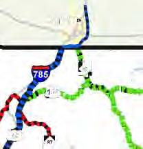
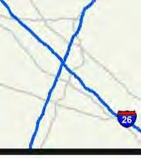
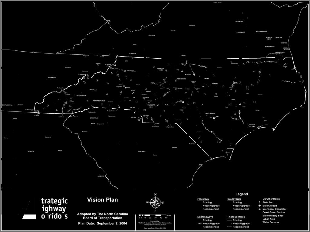
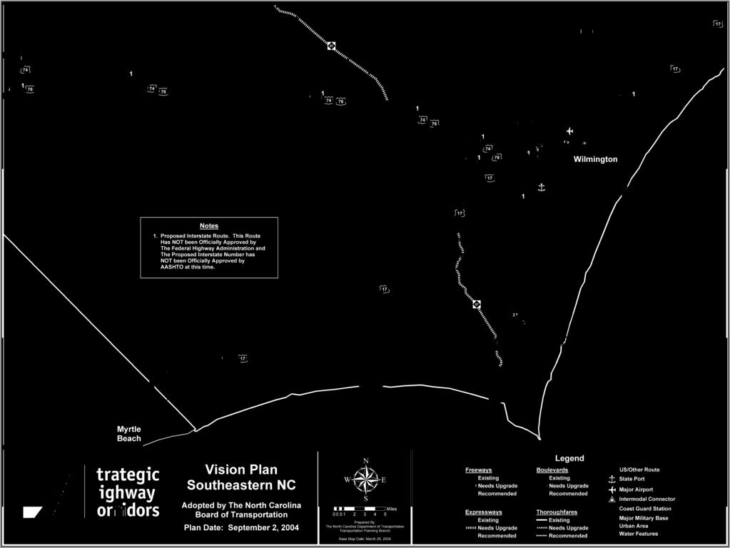
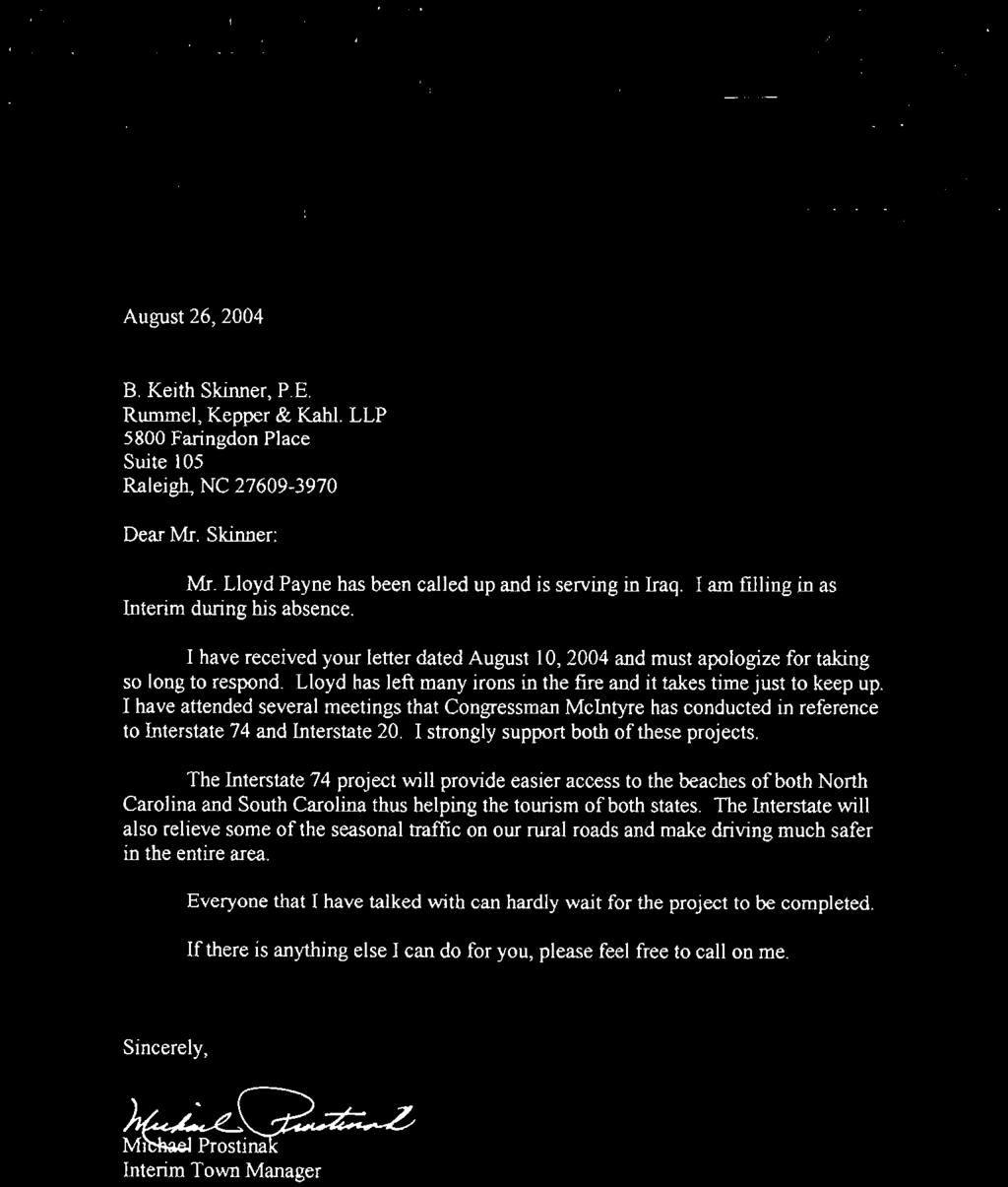
3 From Union Valley Road (SR 1585) in Whiteville To the South Carolina State Line Brunswick and Columbus Counties Divisions 3 and 6 R-3436 RE-EVALUATION I. General Description This feasibility study addresses additional alignment alternatives for the proposed Interstate 74 from Union Valley Road (SR 1585) in Whiteville, Columbus County to the South Carolina state line in Brunswick County. The Project Study Map, included in Part VIII Figures in the back of this report, displays an overview of the project s location. The study corridor begins west of the US interchange with US 71 in Whiteville and continues along existing US to 1.25 miles west of Bolton. It proceeds southward on new location to the Columbus/Brunswick county line. The study corridor travels southward alongside existing NC 211 from the county line to US 17 in Supply. The I-74 corridor then turns southwest and travels along the US 17 corridor, utilizing the Shallotte Bypass, and finally terminating at the South Carolina state line. This study proposes a four-lane divided interstate freeway with full control of access including a variable median from 46 to 7 feet, 12-foot travel lanes, 1-foot full depth outside and 4-foot full depth inside paved shoulders, interchanges, grade separations and service roads within a minimum state maintained right-of-way of 35 feet. Sheets 1 4 are detailed maps of the study alternatives. The total length of the project varies from 63.3 miles to 65.5 miles, depending on which alignments are selected. See Part IV Studied Alternatives for a detailed description of studied alternatives within each section including lengths. This study is the initial step in the planning and design process for this project and is not the product of exhaustive environmental or design investigations. The purpose of this study is to describe the proposed project, including costs, and to identify potential problems that may require consideration in the planning and design phases. II. Need for Project The I-74 corridor, as studied in this report and supported by the Governor of North Carolina, has been identified as a Strategic Highway Corridor (SHC) in the Statewide Transportation Plan adopted by the Board of Transportation on September 2, 24. Many transportation needs can be satisfied through this study s potential alignment of I-74, including the completion of a vital section of the proposed I-74 interstate from Michigan to South Carolina, as well as the achievement of an important milestone in the Governor s and the North Carolina Department of Transportation s (NCDOT) goals for southeastern North Carolina. The NCDOT developed the SHC policy in partnership with the Office of the Governor, the North Carolina Department of Commerce and the North Carolina Department of Environment and Natural Resources. This particular corridor can be seen on the Vision Plan for Southeastern NC. A copy of the Vision Plan of Southeastern NC can be found in Appendix A in the back of this report. The regional goal of the Governor s plan is to provide an economic boost for the area with this new interstate (I-74) in conjunction with other projects such NCDOT Feasibility Study R-3436REEV I-74 Page 3 of 23
4 as interstate I-2 and the extension of the Wilmington Outer Loop. The addition of the proposed I-74 interstate in southeastern North Carolina will be an excellent upgrade to North Carolina's transportation infrastructure and should improve safety and efficiency as well as ignite long-term economic growth in this area of our state. In addition, as stated in the NCDOT s SHC policy, these corridors are critical to statewide mobility and connectivity and promote a vision of modern, efficient transportation supportive of economic opportunities and environmental excellence. More information about the SHC policy and the Statewide Transportation Plan can be found on the NCDOT Transportation Planning Branch website. III. Adjacent Projects The North Carolina Department of Transportation (NCDOT) in coordination with the South Carolina Department of Transportation (SCDOT) is currently developing a feasibility study to extend the multi-lane Carolina Bays Parkway (CBP) facility (future I-74) from SC 9 in Horry County, South Carolina to NC 94 near US 17 in Brunswick County, North Carolina. The study overlaps this I-74 study from the South Carolina state line to NC 94 and is scheduled for completion by the end of this year. The CBP study had identified six alternative corridors. Based upon input gathered during a North Carolina public information meeting earlier this year, NCDOT decided to expand the study area and examine additional corridors. At least two additional corridors are to be evaluated within the North Carolina study area, one north of Brunswick Plantation and one in the southern portion of the study area. The Brunswick Plantation community is located at the US 17/Hickman Road (SR 133) intersection. More information can be found on the NCDOT Transportation Planning Branch website, as well as the South Carolina Department of Transportation s website, This I-74 study will include costs for proposed improvements from NC 94 to the South Carolina state line. The total project cost for the R-3436 Reevaluation study will be revised to reflect the CBP feasibility study findings upon its completion. Coordination with the CBP study should be maintained through subsequent phases of this project. Contact the NCDOT Transportation Planning Branch for information on the Carolina Bays Parkway project. The NCDOT has also initiated a study to develop and coordinate a plan of innovative alternatives to protect the integrity of and maintain mobility along the US 17 Strategic Highway Corridor in Brunswick County (R-4732). The study includes a segment of US 17 that this I-74 corridor study also includes from Supply, NC to the South Carolina state line. Coordination has taken place regarding interchange and service road locations on the freeway alternative of the R-4732 study. The R-4732 study freeway alternative is similar to this study s Section 4 and Section 5-Alternative A. The first phase of the R-4732 corridor study and an Existing Conditions Report were completed in April 24. The second phase of developing alternatives and an Alternatives Report is nearing completion. Two citizens' informational workshops and a transportation summit were held to receive input from and provide information to the public. More detailed information of these meetings, including copies of reports, handouts, and maps may be found on the NCDOT Transportation Planning Branch website, A final report with completed functional designs of detailed study alternatives is scheduled for completion in the fall of 25. Coordination with the R-4732 corridor study should be maintained throughout the phases of this project. Contact the Congestion Management group of the NCDOT Traffic Engineering & Safety Systems Branch for information on the R-4732 project. NCDOT Feasibility Study R-3436REEV I-74 Page 4 of 23
5 The NCDOT has a project (R-4462) listed in the current Transportation Improvement Program (TIP) to upgrade to interstate standards approximately 4 miles of the US facility in Columbus and Brunswick Counties. The project begins in Whiteville and extends to the proposed Wilmington Bypass. R-4462 is currently listed as post years and is unfunded. This project overlaps approximately 19.2 miles of the I-74 study from Whiteville to Bolton. Existing US is Full Control of Access from Chadbourn to just east of Whiteville and Limited Control of Access from there eastward. Items needed to upgrade the eastern portion to interstate standards include improved paved shoulders, median protection such as cable guiderail, and removing at-grade intersections. This study includes improvements needed to upgrade US to interstate standards from Whiteville to just west of Bolton. Coordination with this project should continue through subsequent phases of R Improvements to existing US (Section 1) can be excluded in future phases if construction of R-4462 occurs prior to this project. There are several additional adjacent projects listed in the TIP within the vicinity of the study corridors. Although these projects are near the study corridor, this study s proposed improvements are not directly affected by these projects. In Columbus County, Division 6, TIP project R-61C proposes constructing an interchange at the US intersection with NC 211 in Bolton. Planning and design for this project is in progress and construction is future year 21. This study s corridors bypass Bolton to the southwest and do not likely affect the need for this interchange. However, coordination between R-61C and R-3436 Reevaluation should be maintained to optimize interchange spacing in the area. In Brunswick County, Division 3, there are several TIP projects within the vicinity of the study: R-3432, U-3462, U-3463, U-3473, B-4438, and B-444. The U-3462 project proposes realigning SR 1357 (Smith Avenue)/NC 13 to eliminate offset intersections. Planning and design for this project is in progress and construction is future year 28. With this project there is the potential rerouting of NC 13 to Smith Avenue through Shallotte. The potential rerouting of NC 13 should be considered during future planning and design phases of R-3436 in order to optimize the interchange location and spacing along the Shallotte Bypass. IV. Studied Alternatives This Feasibility Study evaluates several functional alternatives for the I-74 corridor. As described previously, the studied route generally takes I-74 east along existing US from Whiteville to west of Bolton, then south along NC 211 to Supply, and finally southwest along US 17 and the Shallotte Bypass to the South Carolina state line. The study area is primarily rural along existing US and NC 211 with much of the land currently designated as farmland, pine plantation, or swampland. The study area is more developed along NC 211 and US 17 from Supply to the SC state line with many businesses and residences located closely along these existing roadways. All existing roadways to be upgraded and designated I-74 are currently posted 55 mph with the exception of US from Whiteville to east of Red Hill Road (SR 17). The facility is posted 7 mph from Union Valley Road (SR 1585) to US 71 and is posted 6 mph from US 71 to east of Red Hill Road (SR 17). Existing US is a four-lane divided highway with part full control and part limited control of access, a varying median width (approximately 46 to 7 feet), and paved shoulders not currently up to interstate standards. Existing NC 211 is a two-lane two-way roadway with substandard lane and shoulder widths within a state maintained right-of-way of 6 to 15 feet. Existing US 17 is also a four-lane median divided highway with no control of access NCDOT Feasibility Study R-3436REEV I-74 Page 5 of 23
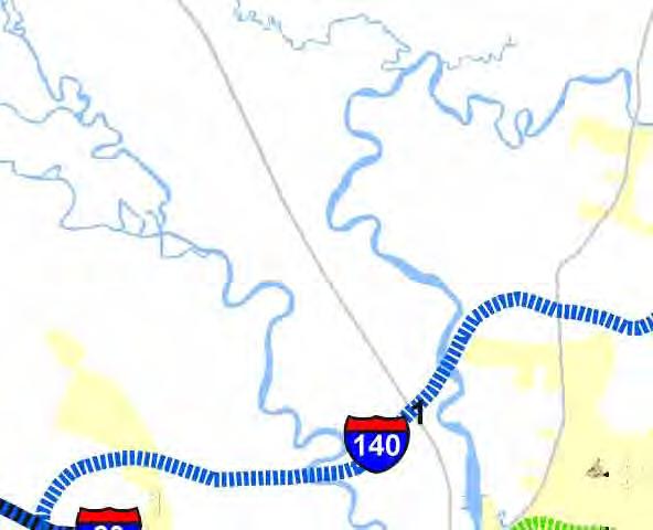
6 (Shallotte Bypass has limited access) along the majority of the study corridor, an approximate 6-foot median, and paved shoulders not currently up to interstate standards. This study identifies probable impacts to properties within the proposed right-of-way of the various functional alternatives. The studied corridors also attempt to minimize the impacts to wetlands. Impacts will be identified and evaluated in greater detail in subsequent planning and design stages. Design criteria for the functional alternatives are based on NCDOT and American Association of State Highway and Transportation Officials (AASHTO) design standards for interstate freeways. The proposed typical for all alternatives is a four-lane divided interstate freeway with full control of access including a variable median from 46 to 7 feet, 12-foot travel lanes, 1-foot full depth outside and 4-foot full depth inside paved shoulders, interchanges, grade separations and service roads within a minimum state maintained right-of-way of 35 feet. As a rule, minimum interchange spacing for interstates should be one mile in urban areas and three miles in rural areas. In urban areas, spacing of less than one mile may be acceptable with collector-distributor roads. This study includes preliminary recommendations for interchange, grade separation and service road locations. Unless otherwise specified, all proposed interchanges refer to diamond interchanges that will allow for future loop construction. For the purpose of this report, the project has been divided into six sections. There is only one alignment considered in Sections 1 and 6. There are several alternatives and alignments considered in Sections 2, 3, 4 and 5. Refer to the Project Study Map and Sheets 1 4, included in Part VIII Figures in the back of this report, for Alternative and Section locations as well as proposed mainline typical sections. The following describes each of the project sections and alternatives and the proposed improvements associated with each. Section 1 Section 1 begins at Union Valley Road (SR 1585) in Whiteville and continues east along existing US to 1.25 miles west of NC 211 in Bolton. The total length of Section 1 is 19.2 miles. Existing US is a full control of access facility from the beginning of the section to the Red Hill Road (SR 17) interchange east of Whiteville. The posted speed limit along this portion of US varies from 6 to 7 mph. The existing paved shoulders are 4 feet wide. The remainder of the section to Bolton is limited control of access. The existing posted speed limit along US in this area is 55 mph. The existing paved shoulders vary from 2 to 4 feet wide. The NCDOT paved shoulder policy requires 4-foot median paved shoulders and 1-foot outside paved shoulders on interstate facilities. The existing median through the section varies from 46 to 2 feet wide. Median widths of 7 feet or less require median guiderail. Proposed work in Section 1 consists of improving the roadway to a full control of access facility meeting all interstate standards, including installing median protection where needed, widening paved shoulders to interstate standards, and changing existing at-grade intersections as described below. There are three existing at-grade intersections along US in Section 1: Hallsboro Road (SR 11), Chauncey Town Road (SR 1735), and Old Lake Road (SR 174). AASHTO standards recommend 3-mile minimum interchange spacing in rural areas. There is sufficient spacing at these locations with the exception of between Chauncey Town Road (SR 1735) and Old Lake Road (SR 174) in Lake Waccamaw. It is recommended to convert one of these two intersections to a grade separation because of the inadequate spacing between the two routes. There are adequate alternative routes connecting the two locations; i.e. NC 214, which parallels US In addition, NCDOT Feasibility Study R-3436REEV I-74 Page 6 of 23
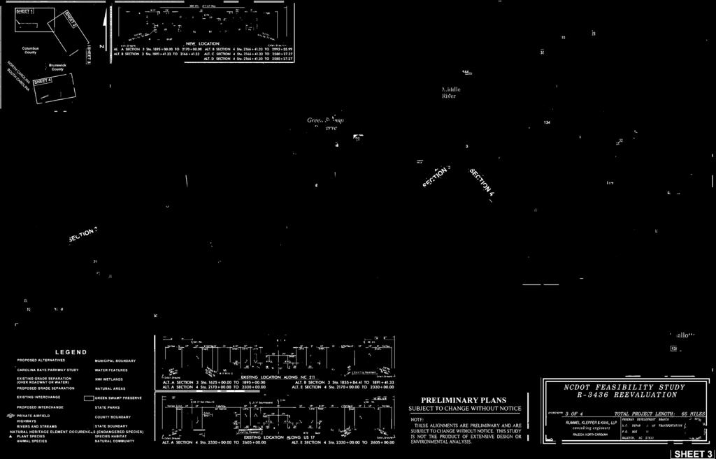
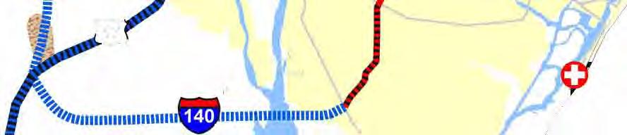
7 one interchange can sufficiently handle the projected 23 traffic volumes of both the Chauncey Town Road (SR 1735) and Old Lake Road (SR 174) intersections. According to Division 6 staff, Chauncey Town Road (SR 1735) is the main access road to the Town of Lake Waccamaw and is the preferred route for local residents (see Appendix B). This study recommends proposed interchanges at Hallsboro Road (SR 11) and Chauncey Town Road (SR 1735) and a grade separation at Old Lake Road (SR 174). The proposed alignment of the grade separation at Old Lake Road (SR 174) is east of the existing roadway to minimize impacts to East Columbus High School located in the northwest quadrant of the crossroads. Sheets 1 and 2 included in Part VIII Figures show proposed interchange and grade separation locations and proposed typical sections for Section 1. The existing right-of-way width, which varies from 15 to 35 feet through this section, will accommodate the paved shoulder and median improvements. Varying amounts of proposed right-of-way are needed to accommodate the at-grade intersection improvements. The majority of proposed work will occur within existing right-of-way areas and additional impacts are expected to be low in this section. Section 1 improvements also include installation of a pair of truck weigh stations and a pair of rest areas. AASHTO recommends having rest areas at intervals of approximately one hour of driving time. An ideal site for these rest areas would be on US near Lake Waccamaw. This location has water and sewer utilities available, and would be approximately one hour from the next nearest developed areas of Supply and Shallotte, along US 17. The weigh stations should be located somewhere along US near Whiteville at the recommendation of the NCDOT feasibility study right-of-way and construction estimators. The construction and right-of-way costs associated with installing of a pair of truck weigh stations and a pair of rest areas has been included in the Section 1 costs below. It is anticipated that Section 1 improvements will require the relocation of two (2) residences and no () businesses. The total cost, including construction and right-of-way, is estimated to be $ 95,,. Highway Weigh Station Rest Area Section Cost Construction $ 65,, $ 12,, $ 8,, $ 85,, Right-of-way $ 2,9, $ 3,9, $ 3,2, $ 1,, Subtotal.. $ 67,9, $ 15,9, $ 11,2, $ 95,, Section 2 Section 2 begins 1.25 miles west of NC 211 in Bolton and continues southeast to the Columbus/Brunswick County line near NC 211 on new location. There are two alternatives considered in Section 2: Alternative A and Alternative B. The total length of Alternative A is 1.2 miles and the length of Alternative B is 1.3 miles. Alternatives A and B both depart the existing US roadway on new location just west of Bolton at a proposed trumpet interchange. Both alternatives continue southeast with grade separations at NC 214 and Tram Road (SR 176) and an interchange at NC 211. Approximately 2 miles north of the county line, Alternative B turns easterly, bypassing the Honey Island community and crosses the county line 2.4 miles east of existing NC 211. Alternative A crosses the county line 1.6 miles east of NC 211. All proposed crossroads on Alternatives A and B are bridged over the interstate with the exception of NC 214 in Bolton. Less impact on existing development will result from the two interstate alternatives crossing over NC 214. Land use NCDOT Feasibility Study R-3436REEV I-74 Page 7 of 23
8 throughout Section 2 is mostly pine plantation and other agricultural farmlands. Although the alternatives traverse wetlands, tree farming has previously disturbed the majority of the areas. The alternatives also avoid undisturbed natural areas of the Friar Swamp near Bolton. The impact to utilities is expected to be low in this section. Sheet 2, included in Part VIII Figures, shows interchange and grade separation locations and proposed typical sections for Section 2. Section 2-Alternative A It is anticipated that Section 2-Alternative A improvements will require the relocation of four (4) residences and no () businesses. The total cost, including construction and right-of-way, is estimated to be $ 1,9,. Construction $ 97,, Right-of-way..$ 3,9, Total Cost (Sec. 2-Alt. A)....$ 1,9, Section 2-Alternative B It is anticipated that Section 2-Alternative B improvements will require the relocation of four (4) residences and no () businesses. The total cost, including construction and right-of-way, is estimated to be $ 12,8,. Construction $ 99,, Right-of-way..$ 3,8, Total Cost (Sec. 2-Alt. A)....$ 12,8, Section 3 Section 3 begins at the Columbus/Brunswick County line near NC 211, proceeds southward along the existing NC 211 corridor and ends 1.1 miles north of Little Macedonia Road (SR 1343) on NC 211 in Middle River, Brunswick County. There are two alternatives considered in Section 3. Alternative A has a total length of 11.5 miles and Alternative B has a total length of 11.3 miles. Both Alternatives A and B cross Honey Island Swamp, Exum Road (SR 134), Bear Pen Island Swamp, go around the Green Swamp Preserve and cross Old C.C. Road. Outside of the Green Swamp Preserve, the majority of land through Section 3 is used for tree farming and other agricultural uses. Both Section 3 alternatives travel around the western boundary of the Green Swamp Preserve (see Sheet 3, Part VIII Figures). Aligning the interstate along the NC 211 corridor would have a detrimental impact to the Green Swamp. The Nature Conservancy (TNC) owns, maintains and protects the Green Swamp Preserve. As discussed in a meeting with TNC, NCDOT and TNC agreed that the endangered species habitat was a compelling reason to align the roadway along the western boundary of the preserve (see Appendix B letter from TNC). Species found in the Preserve include the red-cockaded woodpecker, the rough-leaf loosestrife, pine savanna, and the venus flytrap. The following table displays the State and Federal Status of these rare species: NCDOT Feasibility Study R-3436REEV I-74 Page 8 of 23
9 Group Bird Vascular Plant Vascular Plant Natural Community Green Swamp Preserve Species Status Common State Federal State Global Name Status Status Rank Rank Red-cockaded Woodpecker Endangered Endangered Imperiled Very Rare Rough-leaf Rare or Endangered Endangered Loosestrife Uncommon Very Rare Venus Flytrap Significantly Rare, Special Concern Federal Species of Concern Pine Savanna - - Rare or Uncommon Imperiled to Rare or Uncommon Very Rare Very Rare The above information was taken from the N.C. Department of Environment and Natural Resources (DENR) Natural Heritage Program database. In addition to the rare species located within the preserve, the controlled burning of savanna necessary to maintain biodiversity in the preserve is less likely to affect the highway if it is located west of the preserve and existing NC 211 in Section 3. The proposed interchange spacing along the NC 211 corridor (Sections 2 and 3) varies from 4.8 to 1 miles. The 1-mile interchange spacing may be considered undesirable but is acceptable based on land use and sparse population along this corridor. Breaks in the median cable guiderail will provide access for maintenance and emergency vehicles and NC 211 provides adequate access to and from the interstate. In addition, as TNC suggested at a meeting with NCDOT, not placing an interchange between Honey Island and Middle River may help protect the natural environment of the Green Swamp from undesired growth. A proposed 35-foot right-of-way width on new location will accommodate the interstate and service roads. Portions of the alternatives that parallel NC 211 utilize the existing roadway as a parallel service road. These parts of the alternatives require approximately 22 feet of proposed right-of-way in combination with the existing NC 211 right-of-way. Sheets 2 and 3 included in Part VIII Figures show Section 3 interchange and grade separation locations and proposed typical sections. Section 3-Alternative A Section 3-Alternative A begins 1.6 miles east of existing NC 211 and proceeds in a southeast direction for 11.5 miles. 5.1 miles of this section are alongside NC 211 and 6.4 miles are on new location. The existing posted speed limit along NC 211 is 55 mph. The portion that parallels NC 211 uses the existing two-lane roadway as a service road and constructs the interstate to the east of NC 211. One horizontal curve on NC 211 in Section 3, located where Alternative A and B join, requires improvement to accommodate interstate speeds. A more detailed study is needed to determine exact locations of service roads on new location parts of the alternative. Section 3-Alternative A proposes bridging two crossings within the Honey Island Swamp, an interchange with Exum Road (SR 134), bridging a crossing of the Bear Pen Island Swamp, a grade separation with relocated NC 211 and a grade separation with Old C.C. Road. All proposed crossroads are bridged over the interstate. This section alternative includes one diamond interchange, two grade separations, and three natural systems bridges. The impact to utilities is expected to be low in this section. NCDOT Feasibility Study R-3436REEV I-74 Page 9 of 23
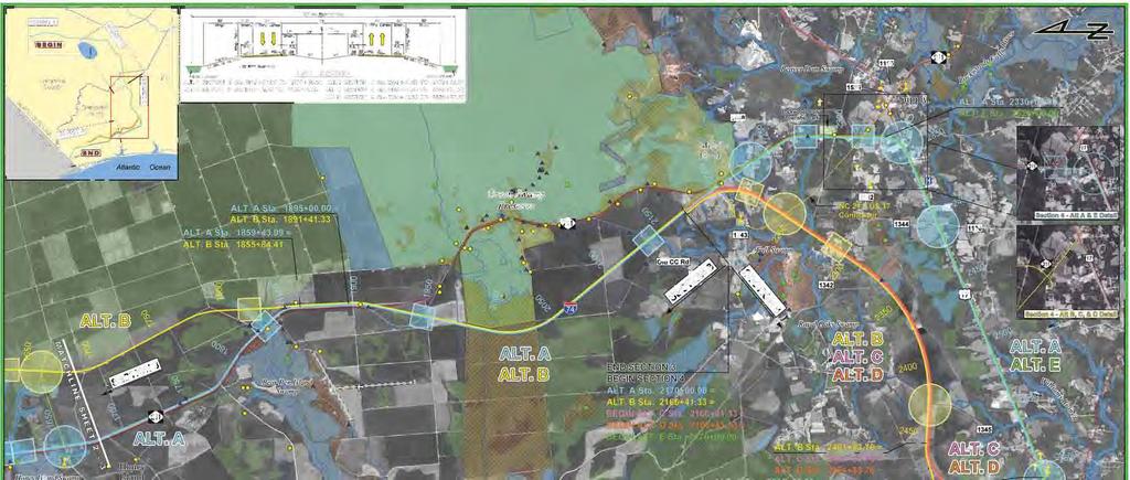
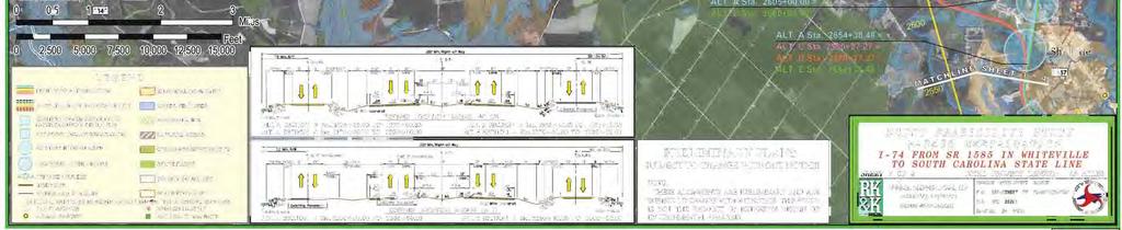
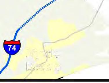
10 Alternative A will impact the Honey Island community and natural areas located in the Honey Island and Bear Pen Island Swamps. Although the area is sparsely populated, there are several residences and one church cemetery located near the NC 211/Exum Road (SR 134) intersection. In addition, plant and animal Natural Heritage Element Occurrences (NHEO) can be found in the swamps as shown on Sheets 2 and 3, Part VIII Figures in the back of this report. It is anticipated that Section 3-Alternative A improvements will require the relocation of six (6) residences and one (1) business. The total cost, including construction and right-of-way, is estimated to be $ 16,3,. Construction.. $ 13,, Right-of-way..$ 3,3, Total Cost (Sec. 3-Alt. A)....$ 16,3, Section 3-Alternative B Section 3-Alternative B begins approximately 2.4 miles east of existing NC 211 and proceeds in a southeast direction for approximately 11.3 miles. Approximately.7 miles of this section are alongside NC 211 and 1.6 miles are on new location. A more detailed study is needed to determine exact locations of service roads on new location parts of the alternative. Section 3-Alternative B proposes bridging one crossing of the Honey Island Swamp, an interchange with an extension of Exum Road (SR 134), bridging a crossing of the Bear Pen Island Swamp, a grade separation with relocated NC 211 and a grade separation with Old C.C. Road. Although Alternative B traverses a significant amount of wetlands in the northern part of the section, tree farming has previously disturbed most of these areas. This alternative bypasses the Honey Island community to the east and proposes a 1-mile connector from Exum Road (SR 134) to an interchange with Alternative B. All proposed crossroads in the section are bridged over the interstate. NC 211 and Exum Road (SR 134) provide local access to and from the interstate. Alternative B also has minimal impact to the Honey Island and Bear Pen Island Swamps. This section alternative includes one diamond interchange, two grade separations, and two natural systems bridges. It is anticipated that Section 3-Alternative B improvements will require the relocation of no () residences and no () businesses. The total cost, including construction and right-of-way, is estimated to be $ 15,2,. Construction.. $ 13,, Right-of-way..$ 2,2, Total Cost (Sec. 3-Alt. B)....$ 15,2, Section 4 Section 4 begins approximately 1.1 miles north of Little Macedonia Road (SR 1343) on NC 211 in Middle River and ends at NC 94 southwest of Shallotte. There are five alternatives considered in Section 4 ranging in lengths from 15.5 to 17.7 miles. Four of the alternatives utilize the existing US 17 Shallotte Bypass. One alternative is completely on new location. Sheets 3 and 4 and the Project Study Map, included in Part VIII Figures, show these alternatives. NCDOT Feasibility Study R-3436REEV I-74 Page 1 of 23
11 A proposed 35-foot right-of-way width will accommodate the interstate and service roads. Portions of the alternatives that parallel existing roadways require a combination of proposed and existing right-of-way. Parts of the alternatives that utilize the Shallotte Bypass will require no additional right-of-way for the mainline. Sheets 3 and 4, included in Part VIII Figures, show Section 4 interchange and grade separation locations and proposed typical sections. The following describes each of the five alternatives in Section 4. Section 4-Alternative A Section 4-Alternative A utilizes existing roadway corridors. It parallels NC 211 from Middle River to Supply, parallels US 17 from Supply to Shallotte, utilizes the existing Shallotte Bypass, and parallels US 17 to NC 94. The total length of this alternative is 17.7 miles; 3. miles alongside NC 211, 1.5 miles parallel to US 17, and 4.2 miles on existing Shallotte Bypass. The existing Shallotte Bypass is a limited access facility with one interchange and three at-grade intersections. The part of the alternative along the Shallotte Bypass uses the existing roadway and improves the facility to full control of access. The portion of the alternative that parallels NC 211 uses the existing two-lane roadway as a service road and constructs the interstate to the west of NC 211. Refer to the Existing Location Along NC 211 typical section on Sheets 2 and 3, included in Part VIII Figures. The portion that parallels US 17 uses the existing northbound lanes as a two-lane, two-way access road. The existing US 17 southbound lanes are utilized as the proposed northbound interstate lanes and the rest of the roadway section is built to the north of existing US 17. Refer to the Existing Location Along US 17 typical section on Sheets 3 and 4, included in Part VIII Figures. A preliminary count of residences and businesses was made along US 17. Approximately 2/3 of all residences and businesses are located along the southern side of the highway, including the Brunswick Community Hospital. In addition, major utilities are located along the southern side of the highway. Locations along the northern side of the highway that will be significantly impacted include the new Brunswick Medical Park, Brunswick County EMS, two car dealerships, and Lehew/Chapel Hill Cemetery. Lehew/Chapel Hill Cemetery is located within the footprint of the northern Shallotte Bypass/US 17 Business interchange (see Sheet 3 Part VIII Figures). Alternative A will take approximately 65 existing graves and 35 plots in the cemetery. However, to minimize the overall impacts to existing US 17, this study proposes constructing Alternative A on the north side of existing US 17. Section 4-Alternative A includes two trumpet interchanges, five diamond interchanges, two grade separations over roadways and one bridging over a natural system. The alternative proposes an interchange with Little Macedonia Road (SR 1343)/Middle River Road (SR 1448), bridging a crossing of the Royal Oak Swamp, a grade separation with Big Macedonia Road (SR 1342), a trumpet interchange with US 17 near Supply, and an interchange at Mt. Pigsah Road (SR 113)/Sellers Road (SR 1344) near Brunswick Community Hospital. Along the Shallotte Bypass Alternative A proposes a trumpet interchange with US 17 Business at the northern end of the bypass, a grade separation with Smith Ave (SR 1357), utilizes the existing NC 13 interchange, and proposes an interchange with US 17 Business/Old Shallotte Road (SR 1316) at the southern end of the bypass. South of the bypass, interchanges with Ocean Isle Beach Road (SR1184) and NC 94 are proposed. All proposed crossroads are bridged over the interstate with the exception of the grade separation at Big Macedonia Road (SR 1342) in Supply. Development will be less impacted from the interstate alternative crossing over Big Macedonia Road (SR 1342). It also facilitates maintaining the existing Big Macedonia Road (SR 1342)/NC 211 intersection. In Shallotte, Smith Ave (SR 1357) is to be NCDOT Feasibility Study R-3436REEV I-74 Page 11 of 23
12 extended northward on new location to facilitate the construction of the grade separation. At the Ocean Isle Beach Road (SR1184) interchange, the existing road tees into US 17. Extending Ocean Isle Beach Road (SR1184) northward.4 mile to Old Shallotte Road (SR 1316) is part of the proposed improvements of Alternative A. The spacing between interchanges along Alternative A varies from 1.25 to 3.8 miles. The 1.25-mile spacing between the northern trumpet interchange and the Sellers Road (SR 1344)/ Mt. Pigsah Road (SR 113) interchange may be considered less than desirable but is necessary in order to provide access to the community hospital located on US 17 just east of Mt. Pigsah Road (SR 113). The spacing between the existing NC 13 interchange and the southern US 17 Business interchange is 1.3 miles and is acceptable for an urban area. The impact to utilities is expected to be low along the Shallotte Bypass and moderate along the remainder of the alternative. Alternative A, in summary, utilizes existing roadway corridors to construct the interstate and avoids environmental impacts that would occur from a new location alternative. However, there will be significant human environment impacts along existing US 17 prior to and after the Shallotte Bypass. A proposed 35-foot right-of-way width will accommodate the interstate and adjacent service roads. Along NC 211 approximately 22 feet of additional right-of-way is needed. Along US 17 approximately 175 feet of additional right-of-way is needed. No additional right-of-way is needed for the mainline along the existing US 17 Shallotte Bypass. Sheets 3 and 4 included in Part VIII Figures show interchange and grade separation locations and proposed typical sections for Section 4-Alternative A. It is anticipated that Section 4-Alternative A improvements will require the relocation of eighty (8) residences and eighty-three (83) businesses. The total cost, including construction and right-of-way, is estimated to be $ 269,3,. Construction.. $ 196,, Right-of-way...$ 73,3, Total Cost (Sec. 4-Alt. A)....$ 269,3, Section 4-Alternative B Section 4-Alternative B is entirely on new location north of existing US 17. It turns southwest from Middle River onto new location and ends at NC 94, 1. mile north of US 17. The total length of the alternative is 15.5 miles. Section 4-Alternative B has four diamond interchanges and two grade separations. The alternative proposes a grade separation over Little Macedonia Road (SR 1343) in Middle River, an interchange with a proposed NC 211/US 17 connector, a grade separation with Big Macedonia Road (SR 1342), an interchange with Royal Oak Road (SR 1345), an interchange with NC 13, 1.2 miles northwest of the Shallotte Bypass, and an interchange with NC 94, 1. mile north of US 17. All proposed crossroads are bridged over the interstate. The NC 211/US 17 connector is a 2.6-mile multi-lane roadway that links Supply to the proposed interstate. The spacing between interchanges along Alternative B varies from 3.4 to 5.6 miles and is acceptable for rural interstates. The impact to utilities is expected to be low for this alternative. This alternative, in summary, avoids much of the existing development along NC 211 and US 17 and avoids large wetland areas to the north of the corridor. NCDOT Feasibility Study R-3436REEV I-74 Page 12 of 23
13 A proposed 35-foot right-of-way width will accommodate the interstate and service roads. A more detailed study of the new location alternative is needed to determine exact locations of service roads. Sheets 3 and 4 included in Part VIII Figures show interchange and grade separation locations and proposed typical sections for Section 4-Alternative B. It is anticipated that Section 4-Alternative B improvements will require the relocation of eighteen (18) residences and three (3) businesses. The total cost, including construction and right-of-way, is estimated to be $ 169,,. Construction.. $ 159,, Right-of-way...$ 1,, Total Cost (Sec. 4-Alt. B)....$ 169,, Section 4-Alternative C Section 4-Alternative C begins on new location, connects to the US 17 Shallotte Bypass, moves back onto new location just west of the NC 13 interchange and continues to NC 94, 1. mile north of US 17. The total length of the alternative is 16.3 miles; approximately 14 miles on new location and approximately 2 miles on existing US 17 Shallotte Bypass. The existing Shallotte Bypass is a limited access facility with one interchange and three at-grade intersections. The portion of Alternative C along the Shallotte Bypass utilizes the existing roadway and improves the facility to full control of access. Section 4-Alternative C includes two trumpet interchanges, three diamond interchanges, one modified existing interchange and three grade separations. The alternative proposes a grade separation over Little Macedonia Road (SR 1343) in Middle River, an interchange with a proposed US 17 connector, a grade separation with Big Macedonia Road (SR 1342), an interchange with Royal Oak Road (SR 1345) and then connects with the Shallotte Bypass between US 17 Business and Smith Ave (SR 1357). Alternative C proposes a trumpet interchange with the Shallotte Bypass, a grade separation with Smith Ave (SR 1357) and moves back onto new location just west of the existing NC 13 interchange. The western NC 13 interchange ramp is realigned to connect to the proposed interstate. Auxiliary lanes are needed between the proposed trumpet interchange and the NC 13 interchange. No other modifications to the NC 13 interchange are necessary. The alternative then proceeds on new location, grade separates McMilly Road (SR 132) and includes an interchange at NC 94, 1. mile north of US 17. All proposed crossroads are bridged over the interstate. At the beginning of Section 4, the NC 211/US 17 connector is a 2.6-mile multi-lane roadway that links Supply to the proposed interstate. The grade separations and interchanges on the new location portion of Alternative C, with the exception of the grade separation at McMilly Road (SR 132), are the same as Alternative B. The grade separation at Smith Ave (SR 1357) is the same as Alternative A. The spacing between interchanges along this alternative varies from 2.8 to 5.8 miles and is acceptable for rural interstates. Although the spacing between the NC 13 interchange and the new location trumpet interchange in Shallotte is less than 1 mile, it satisfies NCDOT criteria with auxiliary lanes connecting the ramps between the interchanges. The impact to utilities is expected to be low for this alternative. Alternative C, in summary, avoids most of the existing development along NC 211 and US 17, avoids large wetland areas to the north, and utilizes an existing interchange and a portion of the existing Shallotte Bypass. NCDOT Feasibility Study R-3436REEV I-74 Page 13 of 23
14 A proposed 35-foot right-of-way width will accommodate the interstate and service roads. A more detailed study of the new location alternative is needed to determine exact locations of service roads. Sheets 3 and 4 included in Part VIII Figures show interchange and grade separation locations and proposed typical sections for Section 4-Alternative C. It is anticipated that Section 4-Alternative C improvements will require the relocation of fifty-three (53) residences and three (3) businesses. The total cost, including construction and right-of-way, is estimated to be $ 18,3,. Construction.. $ 162,, Right-of-way...$ 18,3, Total Cost (Sec. 4-Alt. C)....$ 18,3, Section 4-Alternative D Section 4-Alternative D begins on new location (similar to Alternatives B and C), connects to the US 17 Shallotte Bypass, and parallels US 17 through Shallotte to NC 94 (along Alternative A). The total length of this alternative is 16.4 miles; 7.8 miles on new location, 3.2 miles on existing Shallotte Bypass, and 5.4 miles parallel to US 17. The existing Shallotte Bypass is a limited access facility with one interchange and three at-grade intersections. The portion of Alternative D along the Shallotte Bypass uses the existing roadway and improves the facility to full control of access. The portion that parallels US 17 utilizes the existing northbound travel lanes as a two-lane, two-way access road. The existing US 17 southbound lanes would be utilized as the proposed northbound interstate lanes and the rest of the roadway section would be built to the north of existing US 17. Refer to the Existing Location Along US 17 typical section on Sheets 3 and 4 in Part VIII Figures. Section 4-Alternative D includes one trumpet interchange, five diamond interchanges, and three grade separations. The alternative proposes a grade separation over Little Macedonia Road (SR 1343) in Middle River, an interchange with a proposed NC 211/US 17 connector, a grade separation with Big Macedonia Road (SR 1342), an interchange with Royal Oak Road (SR 1345) and then connects with the Shallotte Bypass between US 17 Business and Smith Ave (SR 1357). Alternative D proposes a trumpet interchange with the Shallotte Bypass, a grade separation with Smith Ave (SR 1357), utilizes the existing interchange with NC 13, and proposes an interchange with US 17 Business/Old Shallotte Road (SR 1316) at the southern end of the bypass. South of the bypass, interchanges with Ocean Isle Beach Road (SR1184) and NC 94 are proposed. All proposed crossroads are bridged over the interstate. At the beginning of Section 4, the NC 211/US 17 connector is a 2.6-mile multi-lane roadway that links Supply to the proposed interstate. The grade separations and interchanges on the new location portion of Alternative D are the same as Alternatives B and C. The interchanges and grade separations from Smith Ave (SR 1357) southward are the same as Alternative A. The spacing between interchanges along Alternative D varies from 1.3 to 3.3 miles and meets AASHTO standards. The impact to utilities is expected to be moderate along US 17 and low along the Shallotte Bypass and new location portions. Alternative D, in summary, avoids the existing development along NC 211 and US 17 from Middle River to Shallotte, avoids large wetland areas to the north, and utilizes existing roadway from the Shallotte Bypass to NC 94. There will, however, be significant human environment impacts along the existing US 17 portion of Alternative D. NCDOT Feasibility Study R-3436REEV I-74 Page 14 of 23
15 A proposed 35-foot right-of-way width will accommodate the interstate and service roads. A more detailed study of the new location portion is needed to determine exact locations of service roads. Sheets 3 and 4 included in Part VIII Figures show interchange and grade separation locations and proposed typical sections for Section 4-Alternative D. It is anticipated that Section 4-Alternative D improvements will require the relocation of thirty-six (36) residences and thirty-eight (38) businesses. The total cost, including construction and right-of-way, is estimated to be $ 219,3,. Construction.. $ 18,, Right-of-way...$ 39,3, Total Cost (Sec. 4-Alt. D)....$ 219,3, Section 4-Alternative E Section 4-Alternative E (similar to Alternative A) begins parallel to NC 211 from Middle River to Supply and parallels US 17 from Supply to Shallotte, utilizes the existing Shallotte Bypass, and then (similar to Alternative C) moves back onto new location just west of the NC 13 interchange and continues to NC 94, 1. mile north of US 17. The total length of the alternative is 17.7 miles; 3. miles alongside NC 211, 5.2 miles parallel to US 17, 2.8 miles on existing Shallotte Bypass, and 6.7 miles on new location. The existing Shallotte Bypass is a limited access facility with one interchange and three at-grade intersections. The part of the alternative along the Shallotte Bypass uses the existing roadway and improves the facility to full control of access. The portion of the alternative that parallels NC 211 uses the existing two-lane roadway as a service road and constructs the interstate to the west of NC 211. The portion that parallels US 17 utilizes the existing northbound travel lanes as a two-lane, two-way access road. The existing US 17 southbound lanes are used as the proposed northbound interstate lanes and the rest of the roadway section is built to the north of existing US 17. Refer to the Existing Location Along US 17 typical section on Sheets 3 and 4, included in Part VIII Figures. Although constructing the new roadway on the north side avoids impacting the hospital and the major utilities, it does significantly impact Lehew/Chapel Hill Cemetery, the new Brunswick Medical Park and other existing development. Alternative E will take approximately 65 existing graves and 35 plots in the cemetery. However, to minimize the overall impacts to existing US 17, this study proposes constructing Alternative A on the north side of existing US 17. Section 4-Alternative E includes three trumpet interchanges, three diamond interchanges, one modified exiting diamond interchange, two grade separations over roadways and one bridging over a natural system. The alternative proposes an interchange with Little Macedonia Road (SR 1343)/Middle River Road (SR 1448), bridging a crossing of the Royal Oak Swamp, a grade separation with Big Macedonia Road (SR 1342), a trumpet interchange with US 17 near Supply, and an interchange at Mt. Pigsah Road (SR 113)/Sellers Road (SR 1344) near Brunswick Community Hospital. Along the Shallotte Bypass Alternative E proposes a trumpet interchange with US 17 Business at the northern end of the bypass, a grade separation with Smith Ave (SR 1357) and moves back onto new location just west of the existing NC 13 interchange. Proposed modifications to the NC 13 interchange are the same as Section 4-Alternative C. The alternative then proceeds on new location, grade separates McMilly Road (SR 132) and includes an interchange at NC 94, 1. mile north of US 17. All proposed crossroads are bridged over the interstate with the exception of the grade separation at Big Macedonia Road (SR 1342) in Supply (similar to Alternative A). NCDOT Feasibility Study R-3436REEV I-74 Page 15 of 23
16 The spacing between interchanges along Alternative E varies from 1.25 to 3.8 miles. With auxiliary lanes proposed between the NC 13 interchange and the new location trumpet interchange at the southern end of the Shallotte bypass (see also Section 4-Alternative C), interchange spacing satisfies NCDOT standards. The impact to utilities is expected to be moderate along US 17 and low along the Shallotte Bypass and new location portions. Section 4-Alternative E, in summary, avoids the existing development along US 17 south of Shallotte to NC 94, avoids large wetland areas to the north, and utilizes existing roadway corridors from Middle River to the Shallotte Bypass. However, there will be significant human environment impacts along existing US 17. It is anticipated that Section 4-Alternative E improvements will require the relocation of ninety-five (95) residences and forty-eight (48) businesses. The total cost, including construction and right-of-way, is estimated to be $ 226,1,. Construction.. $ 174,, Right-of-way...$ 52,1, Total Cost (Sec. 4-Alt. D)....$ 226,1, Section 5 Section 5 begins at NC 94, proceeds southwest alongside US 17, and ends south of Hickman Road (SR133). The section break between Sections 4 and 5 was created because of the Carolina Bays Parkway study extending its study limits to NC 94. Section 5 data will facilitate comparison and coordination between this study and the Carolina Bays Parkway study upon completion of both documents. Refer to Part III Adjacent Projects of this report for additional information on the Carolina Bays Parkway study. There are two alternatives considered in Section 5. Alternative A has a total length of 4. miles and parallels existing US 17. Alternative B has a total length of 4.3 miles and connects Section 4 new location alternatives to existing US 17. Both Alternatives A and B travel through Thomasboro Crossroads. Both alternatives include one grade separation and one interchange. Sheet 4 in Part VIII Figures shows Section 5 interchange and grade separation locations and proposed typical sections. A proposed 35-foot right-of-way width will accommodate the proposed typical section. Portions of the alternatives that parallel existing US 17 require approximately 175 feet of additional right-of-way. Section 5-Alternative A Section 5-Alternative A utilizes existing roadway. The alternative uses the existing US 17 northbound lanes as a two-lane, two-way access road. The existing US 17 southbound lanes are utilized as the proposed northbound interstate lanes and the rest of the roadway section is built to the north of existing US 17. Refer to the Existing Location Along US 17 typical section on Sheet 4 in Part VIII Figures. Alternative A includes a grade separation with Thomasboro Road (SR 1165)/ Pea Landing Road (SR 134) and an interchange with Hickman Road (SR 133). Both propose bridging the crossroads over the interstate. Utility impacts are expected to be moderate in this section. Section 5-Alternative A should be used in conjunction with Section 4-Alternative A or D. NCDOT Feasibility Study R-3436REEV I-74 Page 16 of 23
17 It is anticipated that Section 5-Alternative A improvements will require the relocation of forty (4) residences and thirteen (13) businesses. The total cost, including construction and right-of-way, is estimated to be $ 57,8,. Construction.. $ 39,, Right-of-way..$ 18,8, Total Cost (Sec. 5-Alt. A)....$ 57,8, Section 5-Alternative B Section 5-Alternative B is on new location. This alternative connects Section 4 new location alternatives to existing US 17. Alternative B includes a grade separation with Pea Landing Road (SR 134) and an interchange with US 17/Hickman Road (SR 133). Both locations propose bridging the crossroads over the interstate. Included with the proposed interchange is the relocation of US 17 and Hickman Road (SR 133) to create a more perpendicular approach to the crossing. The interchange concept also includes loop ramps for traffic turning from US 17 onto the interstate. Section 5-Alternative B should be used in conjunction with Section 4-Alternatives B, C or E. It is anticipated that Section 5-Alternative B improvements will require the relocation of sixty-seven (67) residences and four (4) businesses. The total cost, including construction and right-of-way, is estimated to be $ 73,3,. Construction.. $ 44,, Right-of-way..$ 29,3, Total Cost (Sec. 5-Alt. B)....$ 73,3, Section 6 Section 6 begins south of Hickman Road (SR133), proceeds southwest along US 17, and ends at the South Carolina state line. The section break between Sections 5 and 6 is included because of the Carolina Bays Parkway study. The original study limit of the CBP study was at the Hickman Road (SR 133) intersection. Section 6 data will facilitate comparison and coordination between this study and the CBP study upon completion of both documents. Refer to Part III Adjacent Projects for additional information on the Carolina Bays Parkway study. In section 6 only one alignment (worst case scenario) was considered. This alternate has a total length of 2.6 miles and utilizes existing US 17, traveling by the town of Calabash. The costs associated with this alignment are to be used for comparison purposes only. Once the Carolina Bays Parkway study is completed, the cost estimate for Sections 5 and 6 of R-3436 Reevaluation will be revised appropriately. Proposed improvements include an interchange with Calabash Road (SR 13)/Country Club Road (SR 1168). Sheet 4 in Part VIII Figures shows the Section 6 interchange location and typical section. This section proposes constructing the new interstate symmetrically about the existing centerline. A total 35-foot right-of-way width will accommodate the interstate and service roads. Approximately 6 feet of additional right-of-way is needed on each side of existing US 17 through Section 6. Utility impacts are expected to be high in this section. Section 6 improvements also include installation of a North Carolina welcome center located near the South Carolina state line. NCDOT Feasibility Study R-3436REEV I-74 Page 17 of 23
18 It is anticipated that Section 6 improvements will require the relocation of sixty-four (64) residences and twenty-five (25) businesses. The total cost, including construction and right-of-way, is estimated to be $ 84,7,. Highway Welcome Ctr. Section Cost Construction $ 3,, $ 5,, $ 35,, Right-of-way $ 44,1, $ 5,6, $ 49,7, Subtotal.. $ 74,1, $ 1,6, $ 84,7, NCDOT Feasibility Study R-3436REEV I-74 Page 18 of 23
19 V. Traffic Operations The Interstate 74 projected base year 24 Average Daily Traffic (ADT) ranges from 1,5 to 13,7 vehicles per day (vpd). The estimated design year 23 ADT ranges from 16,8 to 57,8 vpd. Along existing US the 23 ADT ranges from 22,6 to 31, vpd. The heaviest volume of traffic is located near Whiteville. The design year traffic along NC 211 ranges from 16,8 to 19,6 vpd with the heaviest volume located near Supply. Along existing US 17, the 23 ADT ranges from 31,7 to 57,8 vpd. The heaviest volumes of traffic are located just before and after the Shallotte Bypass. Along the Shallotte Bypass the 23 ADT varies from 39,6 to 44,. The 23 ADT along new location interstate is estimated to range from 19,6 to 31,7 vpd. The truck traffic along the project is expected to make up 2 to 12% of daily traffic, with the heaviest truck percentages expected along US Based on the length and scope of this study, a detailed capacity analysis evaluation was not developed for all traffic components within the 65 mile corridor. Interstate mainline volumes were evaluated utilizing the Highway Capacity Software (HCS 2) to determine the proposed levels of service (LOS) for this proposed Interstate 74. Traffic forecasts are given in Average Daily Traffic (ADT) volumes. The following table displays the resulting levels of service for the different mainline segments of this study alignment. INTERSTATE LEVELS OF SERVICE Mainline Segment 23 ADT Level of Service (LOS) Section 1 - Along Existing US , B Sections 2 and 3 - On New Location 19,6 A Sections 4 thru 6 - Along Existing US 17 57,8 D Sections 4 thru 6 - On New Location 31,7 B Section 4 - Along Existing Shallotte Bypass 44, C The interchange types proposed in this study were evaluated based on a functional analysis only. A more detailed traffic analysis will be required for the interchanges and intersections in later planning and design phases of the project. In general, fully controlled access facilities such as interstates have lower accident and fatality rates than other roadway facilities. Much of this interstate study corridor travels along existing rural US routes. The existing US and US 17 routes have experienced 13 fatalities within the I-74 study area over the three-year period from September 1, 2 through August 31, 23. The existing US and US 17 routes fatality rates, 1.93 and 2.74 per 1 million vehicle miles (1MVM) respectively, are greater than the statewide fatality rate of 1.45 per 1MVM for rural US routes. The statewide fatality rate, from 2-22, for rural US routes (1.45 per 1MVM) is twice that of rural interstates (.67 per 1 MVM). The statewide crash rate for all accidents for rural US routes ( per 1 MVM) is also approximately twice that of rural interstates (67.62 per 1 MVM). Therefore, constructing a full controlled access interstate freeway will create a safer high-speed facility. In addition, constructing the full controlled access interstate along existing corridors will reduce the potential for accidents and fatalities. NCDOT Feasibility Study R-3436REEV I-74 Page 19 of 23
20 VI. Recommendations The following table shows the associated lengths, residential and business relocations, qualitative environmental impacts, and costs for each of the section alignments studied in this report. SECTION 1 2A 2B 3A 3B 4A 4B 4C 4D 4E 5A 5B 6 Length (Miles) Res./Bus. Relocatees Environ. Impact Constr. Cost* R/W Cost* Section Cost* / 4 / 4 / 6 / 1 low moderate moderate * Costs listed in millions of dollars. / 8 / 83 Section Data Table moderate high / / 4 $18.8 moderate $85. $97. $99. $13. $13. $196. $159. $162. $18. $174. $39. $44. $1. $3.9 $3.8 $95. $1.9 high low high low / 3 53 / 3 low $3.3 $2.2 $73.3 $1. $18.3 $39.3 $52.1 $12.8 $16.3 $15.2 $269.3 SECTION DATA $169. $ / / 48 moderate $ / 25 moderate $35. $49.7 $219.3 $226.1 $57.8 $73.3 $84.7 The following table shows all feasible alignment combinations and their associated data. FEASIBLE ALIGNMENT COMBINATIONS Res./Bus. Environ. 1 2A 2B 3A 3B 4A 4B 4C 4D 4E 5A 5B 6 Relocatees Impact Length (Miles) Total Cost* X X X X X X 196 / 122 high 65.2 $714. X X X X X X 161 / 33 moderate 63.3 $629.2 X X X X X X 196 / 33 moderate 64.1 $64.5 X X X X X X 152 / 77 moderate 63.9 $664. X X X X X X 238 / 78 moderate 65.5 $686.3 X X X X X X 19 / 121 high 65.1 $714.8 X X X X X X 155 / 32 low 63.2 $63. X X X X X X 19 / 32 low 64. $641.3 X X X X X X 144 / 76 moderate 63.8 $664.8 X X X X X X 232 / 77 moderate 65.4 $687.1 * Costs listed in millions of dollars. Recommended Alternative. Alignment Combinations Table NCDOT Feasibility Study R-3436REEV I-74 Page 2 of 23
21 VI. Recommendations With the installation of the interstate each of the alternatives for this project are similar in that they provide safe, high-speed facilities by which to travel to neighboring communities, counties and states. These alternatives also improve accessibility, mobility, and connectivity to the aforementioned areas. Criteria for recommending an alternative for this corridor include traffic safety and operations, as well as functionality, environmental impacts, human development impacts, monetary costs and promoting the goals of the State of North Carolina for a better infrastructure. Section 1 improvements, as described in this study, are required to upgrade this section of the US facility in Columbus County to interstate standards. If the TIP project R-4462 as mentioned in Part III Adjacent Projects becomes funded and scheduled prior to this project, the costs can be excluded from subsequent phases of this project. Therefore, Section 1 improvements are recommended for this study. There are two alternatives considered in Section 2 and Section 3. Alternative A and Alternative B each depart existing US near Bolton in Columbus County and travel along the NC 211 corridor towards Supply in Brunswick County. The only existing development along the NC 211 corridor from Bolton to Supply is located in the Honey Island and Bear Pen Island areas. There are also several Natural Heritage Element Occurrences (NHEO) in these areas. Both alternatives bypass the Green Swamp Preserve to the west. Although Alternative A parallels more of existing NC 211 and utilizes more existing right-of-way than Alternative B, Alternative A will impact Honey Island Swamp and Bear Pen Island Swamp, as well as affect the Honey Island Community. With its more easterly alignment, Alternative B greatly minimizes the impacts to Honey Island Swamp, Bear Pen Swamp, and the surrounding natural areas. Alternative B does impact more wetlands, but these areas are previously disturbed tree farms. The costs for each alternative through Sections 2 and 3 are comparable, as can be seen in the Section Data Table on the previous page. However, since Alternative B adequately serves local residents without causing relocations, satisfies the Green Swamp Preserve owners, provides a feasible interstate corridor and minimizes impacts to Honey Island, Bear Pen Island and the surrounding natural areas, Alternative B in Section 2 and Section 3 is the recommended alternative. There are five alternatives considered in Section 4; Alternatives A through E. Alternative A has less environmental impacts and utilizes more existing roadway than other alternatives. However, it will also have the most relocatees and human environment impacts, the highest costs, and higher volumes of traffic. Alternative B is entirely on new location, has the lowest costs and fewest relocatees. Alternative C which is mostly on new location with a connection to the US 17 Shallotte Bypass, has the 2 nd least expensive costs, the 2 nd least relocatees, and lower environmental impacts than Alternative B. Alternatives D and E fall in between the best and worst alternatives. Alternative A and Alternative E significantly impact the Lehew/Chapel Hill Cemetery. In general, the new location alternatives (i.e. Alternatives B and C) will have higher levels of service than the existing corridor alternatives (i.e. Alternative A, D and E) which place proposed interstate traffic on the existing US 17 corridor. The two foremost alternatives for recommendation are Alternative B and Alternative C because of their lower costs, lower amounts of relocations, and higher levels of service. Alternatives B and C are approximately the same length. Alternative C avoids some natural resource impacts by utilizing the US 17 Shallotte Bypass. Although Alternative C is not the least NCDOT Feasibility Study R-3436REEV I-74 Page 21 of 23
22 expensive, it is the best overall alternative, connecting to the existing US 17 Shallotte Bypass, and avoiding excessive impacts to the human and natural environments. Alternative C, therefore, is the recommended alternative in Section 4. There are two alternatives in Section 5 of the study. Section 5 Alternative A ties into the adjacent alignments that utilize existing US 17; however these alignments were not preferred at this time. Section 5 Alternative B connects to the preferred new location alignment of Section 4 Alternative C. In Section 6 only one alignment (worse case scenario) was considered, as previously explained in Part IV Studied Alternatives. Please recall that Section 5 and 6 improvements shown in this report will be reevaluated at a later date to more accurately reflect the findings of the Carolina Bays Parkway study currently underway. Once the CBP study is completed, Sections 5 and 6 of this study will be revised appropriately. The costs shown here are to be used for comparison purposes only. The recommended alternative includes Section 1, Section 2-Alternative B, Section 3- Alternative B, Section 4-Alternative C, Section 5-Alternative B, and Section 6. The following table shows the total costs for the recommendations in this report. RECEOMMENDED PROJECT COSTS Alternative Construction Cost Right-of-Way Cost Total Section/ Alternative Cost Section 1 $ 85,, $ 1,, $ 95,, Section 2-Alternative B $ 99,, $ 3,8, $ 12,8, Section 3-Alternative B $ 13,, $ 2,2, $ 15,2, Section 4-Alternative C $ 162,, $ 18,3, $ 18,3, Section 5-Alternative B $ 44,, $ 29,3, $ 73,3, Section 6 $ 35,, $ 49,7, $ 84,7, The recommended alternative yields a total project cost of $ 641,3,. NCDOT Feasibility Study R-3436REEV I-74 Page 22 of 23
23 VII. Additional Comments A detailed environmental study was not conducted for this feasibility study. However, an environmental screening did result in the following possible occurrences, which will need further evaluation in subsequent stages of the development of this project: The National Wetland Inventory (NWI) mapping indicates that this project will have impacts to wetlands. Best Management Practices should be used during the design and construction of this project in order to minimize impacts wetlands. NCDOT Division 6 staff states the Department does have a unique opportunity to offset the impacts [to wetlands] by initiating a mitigation strategy that expands the reaches of the Green Swamp Preserve. Refer to page 3 of a letter received from Division 6 staff dated May 2, 24 in Appendix B. The Department of Natural Resources Natural Heritage Section indicates that there are several occurrences of threatened or endangered species located along the study alternatives, especially along NC 211 in Sections 2 and 3. Sheets 1 4, included in Part VIII Figures in the back of this report, show locations of plant and animal Natural Heritage Element Occurrences (NHEO) within the study area. Please also refer to a letter received from The Nature Conservancy (TNC) dated May 14, 24 in Appendix B for more information on particular species located within the Green Swamp Preserve. Other items or comments that should be noted from this study and considered during future planning and design phases of this project: The NCDOT has conducted a previous study of the I-74 corridor (R-3436) which was completed in This previous study s corridor takes a more direct route from Whiteville to the South Carolina state line; proceeding from US 74 on new location west of Whiteville, traveling south across the Waccamaw River at the Columbus/Brunswick County line, and connecting with US 17 west of Shallotte. However, this particular corridor is not shown on the Strategic Highway Corridors Vision Plan for Southeastern NC (see Appendix A). The study corridors from both the R-3436 and R-3436REEV studies are considered alternative routes for the I-74 corridor. The functional design alternatives will produce costs for comparative purposes. Close coordination with adjacent projects should be maintained throughout the phases of this project. Refer to Part III Adjacent Projects of this report for additional information. Several local government officials and NCDOT representatives have expressed support for this Interstate 74 corridor, i.e. the Governor, the Cape Fear Council of Governments, the Town of Shallotte, NCDOT Board Member Lanny Wilson, and the Town of Lake Waccamaw. Please also refer to Appendix B for copies of letters received during the development of this study. NCDOT Feasibility Study R-3436REEV I-74 Page 23 of 23
24 VIII. Figures Project Study Map Sheets 1 to 4 Study Alternatives Maps
25 Sandyfield PRELIMINARY PLANS SUBJECT TO CHANGE WITHOUT NOTICE 17 NOTE: THESE ALIGNMENTS ARE PRELIMINARY AND ARE SUBJECT TO CHANGE WITHOUT NOTICE. THIS STUDY IS NOT THE PRODUCT OF EXTENSIVE DESIGN OR ENVIRONMENTAL ANALYSIS Marsh Whiteville 174 Lake Waccamaw Br an ch Northwest Bolton Buckh Creek Brunswick ea d Lake Waccamaw Sandy Creek Legend Lake Waccamaw State Park Co u n t y bu s Colum C o u nt y ick B r un s w Honey Island Juni p Carolina Bays Parkway Study Water Features Existing Grade Separation (Over Roadway or Water) NWI Wetlands Propos ed Grade Separation Natural Areas Existing Interchange Green Swamp Preserve Proposed Interchange State Parks Private Airfield County Boundary State Boundary Rivers and Streams 134 W a c c ee Municipal Boundary Highways er Cr am Propos ed Alternatives Miles k a w Fayetteville Green Swamp Preserve Ri ve n ty r Old CC Rd u o C c kk Middle River wi w Boiling Spring Lakes 1342 ss u m m a n li na ro oli a C ar C h rt th o b u ss o S lu Co Bolivia nn t y N ou C n u Br Wilminton Supply Mrytle Beach CAROLINA BAYS PARKWAY STUDY Shallotte 1316 NCDOT FEASIBILITY STUDY R-3436 REEVALUATION (TO BE EXTENDED TO NC 94) 134 Varnamtown 13 Hickmans Crossing NOTE: THESE ALIGNMENTS ARE PRELIMINARY AND ARE SUBJECT TO CHANGE WITHOUT NOTICE. THIS STUDY IS NOT THE PRODUCT OF EXTENSIVE DESIGN OR ENVIRONMENTAL ANALYSIS. I-74 FROM SR 1585 IN WHITEVILLE TO SOUTH CAROLINA STATE LINE 133 PRELIMINARY PLANS SUBJECT TO CHANGE WITHOUT NOTICE Oak Island Holden Beach Ocean Isle Beach 1168 Calabash TOTAL PROJECT LENGTH: RUMMEL, KLEPPER & KAHL, LLP 1167 Carolina North Myrtle Beach Shores PROJECT STUDY MAP PROGRAM 1165 Sunset Beach c on su ltin g e n g in e e rs A t l a n t i c O c e a n RALEIGH, NORTH CAROLINA DEVELOPMENT N.C. DEPARTMENT P.O. BOX RALEIGH, OF 65 MILES BRANCH TRANSPORTATION 2521 NC PROJECT STUDY MAP

26 E SH SHEET 1 2 ET N SHEET 3 Columbus County R O C SO TH Brunswick County A N I NA LI L O O AR AR C TH U SHEET 4 Atlantic Ocean 17 nc B ra Bogue S 75 7 mp y B ra Jocke 8 h 65 nb r anc 6 5 pe nch ars h ite M Co w 45 ra g B nc h Wh Whiteville n ch Lo e Br a Molli Pi n e SECTION 1 35 h P n he o unc wa Lake Waccamaw Cove Swamp SECTION 1 Lake Waccamaw Miles LEGEND PROPOSED ALTERNATIVES MUNICIPAL BOUNDARY CAROLINA BAYS PARKWAY STUDY WATER FEATURES EXISTING GRADE SEPARATION (OVER ROADWAY OR WATER) NWI WETLANDS PROPOSED GRADE SEPARATION NATURAL AREAS EXISTING INTERCHANGE GREEN SWAMP PRESERVE PROPOSED INTERCHANGE STATE PARKS PRIVATE AIRFIELD COUNTY BOUNDARY HIGHWAYS RIVERS AND STREAMS STATE BOUNDARY NATURAL HERITAGE ELEMENT OCCURENCES (ENDANGERED SPECIES) PLANT SPECIES SPECIES HABITAT ANIMAL SPECIES NATURAL COMMUNITY Feet 2,5 5, 7,5 1, 12,5 15, NCDOT FEASIBILITY STUDY R-3436 REEVALUATION Brunswick PRELIMINARY PLANS SUBJECT TO CHANGE WITHOUT NOTICE NOTE: THESE ALIGNMENTS ARE PRELIMINARY AND ARE SUBJECT TO CHANGE WITHOUT NOTICE. THIS STUDY IS NOT THE PRODUCT OF EXTENSIVE DESIGN OR ENVIRONMENTAL ANALYSIS. I-74 FROM SR 1585 IN WHITEVILLE TO SOUTH CAROLINA STATE LINE SHEET 1 OF 4 TOTAL PROJECT LENGTH: PROGRAM RUMMEL, KLEPPER & KAHL, LLP c on su ltin g e n g in e e rs RALEIGH, NORTH CAROLINA DEVELOPMENT N.C. DEPARTMENT P.O. BOX RALEIGH, OF 65 MILES BRANCH TRANSPORTATION 2521 NC SHEET 1


27 C n de bu um C ol 2 B la s T EE SH SHEET 1 O N SHEET 3 Columbus County 4 SHEET Ocean SE CT ION 3 95 END SECTION 2 BEGIN SECTION 3 Honey Island 9 Bu c k Honey Island Swamp hea 85 Lake Waccamaw Lake Waccamaw State Park 8 Lake Waccamaw.5 1 unty ick Co Brunsw ounty bus C Colum ch ran db Friar Swamp ION 165 CT 16 SE SE IO N 176 CT END SECTION 1 BEGIN SECTION CT SE 1 5 IO N 2 11 Bolton 14 Atlantic 135 A N INA LI L O O A R AR C C TH TH R U SO Brunswick County Miles LEGEND PROPOSED ALTERNATIVES MUNICIPAL BOUNDARY CAROLINA BAYS PARKWAY STUDY WATER FEATURES EXISTING GRADE SEPARATION (OVER ROADWAY OR WATER) NWI WETLANDS PROPOSED GRADE SEPARATION NATURAL AREAS EXISTING INTERCHANGE GREEN SWAMP PRESERVE PROPOSED INTERCHANGE STATE PARKS PRIVATE AIRFIELD COUNTY BOUNDARY STATE BOUNDARY NATURAL HERITAGE ELEMENT OCCURENCES (ENDANGERED SPECIES) PLANT SPECIES ANIMAL SPECIES PRELIMINARY PLANS SUBJECT TO CHANGE WITHOUT NOTICE Feet 2,5 5, 7,5 1, 12,5 15, NCDOT FEASIBILITY STUDY R-3436 REEVALUATION I-74 FROM SR 1585 IN WHITEVILLE TO SOUTH CAROLINA STATE LINE SHEET 2 OF 4 HIGHWAYS RIVERS AND STREAMS SPECIES HABITAT NATURAL COMMUNITY NOTE: THESE ALIGNMENTS ARE PRELIMINARY AND ARE SUBJECT TO CHANGE WITHOUT NOTICE. THIS STUDY IS NOT THE PRODUCT OF EXTENSIVE DESIGN OR ENVIRONMENTAL ANALYSIS. TOTAL PROJECT LENGTH: RUMMEL, KLEPPER & KAHL, LLP c on su ltin g e n g in e e rs RALEIGH, NORTH CAROLINA PROGRAM DEVELOPMENT N.C. DEPARTMENT P.O. BOX RALEIGH, OF 65 MILES BRANCH TRANSPORTATION 2521 NC SHEET 2 75
28


 1316 31 CAROLINA BAYS PARKWAY STUDY Carolina Shores STATE BOUNDARY RIVERS AND STREAMS 1168 34 5 NATURAL HERITAGE ELEMENT OCCURENCES (ENDANGERED SPECIES) PLANT")
29 PRELIMINARY PLANS SH SHEET 1 EE T SUBJECT TO CHANGE WITHOUT NOTICE 2 N SHEET 3 Columbus County NOTE: THESE ALIGNMENTS ARE PRELIMINARY AND ARE SUBJECT TO CHANGE WITHOUT NOTICE. THIS STUDY IS NOT THE PRODUCT OF EXTENSIVE DESIGN OR ENVIRONMENTAL ANALYSIS. O R 255 A N INA LI L O O AR AR C TH U C SO TH SHEE 26 Brunswick County T4 27 Ocean 1357 Lo o k 275 o ut B r anch SECTION 5 SECTION 4 28 SECTION 5 29 END SECTION 5 BEGIN SECTION Atlantic 5 26 END SECTION 4 BEGIN SECTION 5 N IO CT SE i ll ys p NO RT RO END SECTION 4 BEGIN SECTION 5 Sandy Branch Sand Ridge and Bay Complex N MUNICIPAL BOUNDARY CAROLINA BAYS PARKWAY STUDY WATER FEATURES EXISTING GRADE SEPARATION (OVER ROADWAY OR WATER) NWI WETLANDS PROPOSED GRADE SEPARATION NATURAL AREAS EXISTING INTERCHANGE GREEN SWAMP PRESERVE PROPOSED INTERCHANGE STATE PARKS PRIVATE AIRFIELD COUNTY BOUNDARY LI A RO PROPOSED ALTERNATIVES LI CA CT IO N NA 6 TH CA U H SO 33 5 SECTION 4 LEGEND Shal l otte Riv er HIGHWAYS SE END SECTION 6 o all Shallotte Township Park Swamp 31 w awca w Sh er tte Riv un ee S Lit tl e C R Cool r let ng amp 325 hi wa m S Hickmans Crossing Shallotte Mc M 315 (TO BE EXTENDED TO NC 94) CAROLINA BAYS PARKWAY STUDY Carolina Shores STATE BOUNDARY RIVERS AND STREAMS NATURAL HERITAGE ELEMENT OCCURENCES (ENDANGERED SPECIES) PLANT SPECIES ANIMAL SPECIES SPECIES HABITAT NATURAL COMMUNITY Miles Calabash Feet 2,5 5, 7,5 1, 12,5 15, Sunset Beach NCDOT FEASIBILITY STUDY R-3436 REEVALUATION OceanIIsle - 7 Beach 4 FROM SR 1585 IN WHITEVILLE TO SOUTH CAROLINA STATE LINE SHEET 4 OF 4 TOTAL PROJECT LENGTH: RUMMEL, KLEPPER & KAHL, LLP c on su ltin g e n g in e e rs RALEIGH, NORTH CAROLINA PROGRAM DEVELOPMENT N.C. DEPARTMENT P.O. BOX RALEIGH, OF 65 MILES BRANCH TRANSPORTATION 2521 NC SHEET 4
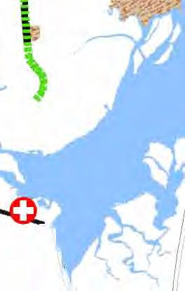
30 APPENDIX A Strategic Highway Corridors - Vision Plan for NC Strategic Highway Corridors - Vision Plan for Southeastern NC


31


32
33 APPENDIX B Letters from Interested Parties
34
35
36
37
38
39
40
41
42
43
44