PORT OF VANCOUVER, USA PARCEL 1A NE LAYDOWN CRITICAL AREAS REPORT
|
|
|
- Geraldine Simon
- 5 years ago
- Views:
Transcription
1 PORT OF VANCOUVER, USA PARCEL 1A NE LAYDOWN CRITICAL AREAS REPORT February 2012 Prepared by: Port of Vancouver, USA 3103 NW Lower River Road Vancouver, Washington
2 CONTENTS 1 Introduction Report Purpose Site Characteristics Background Applicable Regulations Federal Regulations State of Washington Regulations Local Regulations City of Vancouver Existing Conditions and Impacts Habitats of Local Importance Existing Conditions Project Impacts Fish and Wildlife Habitat Conservation Areas Existing Conditions Project Impacts Frequently Flooded Areas Existing Conditions Project Impacts Geologic Hazard Areas Existing Conditions Project Impacts Wetlands Existing Conditions Project Impacts Compliance with Approval criteria Avoid and Minimize Impacts Habitats of Local Importance Frequently Flooded Areas Geologic Hazard Areas Wetlands Minimize Impacts Minimization Measures Best Management Practices... 8 Port of Vancouver, USA Parcel 1A NE Laydown i Critical Areas Report February 2012 Vancouver, Washington
3 5.3 Compensatory Mitigation No Net Loss Consistency with General Purposes Performance Standards Habitats of Local Importance Frequently Flooded Areas Geologic Hazard Areas Wetlands Conclusions References List of Figures Figure 1: Vicinity Map Figure 2: Aerial Site Overview Figure 3. Proposed Site Plan Figure 4. Frequently Flooded Areas Figure 5. Geologic Hazard Areas Figure 6. Wetlands List of Appendices Appendix A: Figures Appendix B: Photographs Appendix C: Floodplain Analysis Appendix D: Wetland Delineation Report Port of Vancouver, USA Parcel 1A NE Laydown ii Critical Areas Report February 2012 Vancouver, Washington
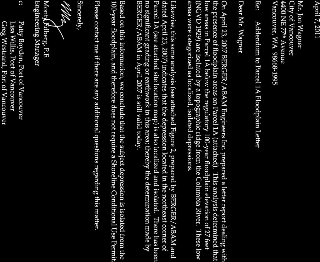
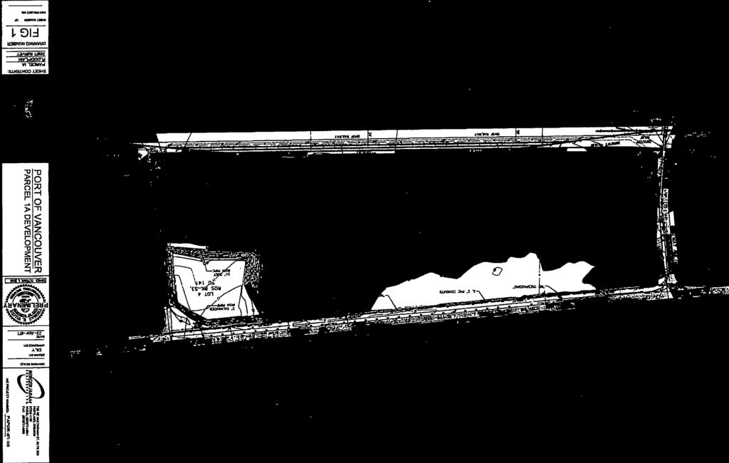
4 1 INTRODUCTION The Port of Vancouver, USA (port) continues to pursue its mission by expanding its operation as necessary to accommodate a greater diversity and quantity of cargoes. This includes maximizing the economic potential of its assets to derive economic benefit for the community. The port s growth projections conclude that more cargo storage area is needed to support port operations. Current cargo storage area is fully utilized at peak vessel off loading periods. Parcel 1A (City of Vancouver Parcel Number ), if graded, could offer additional cargo storage area for the port (Figure 1, Figure 2). Development of the parcel will affect a 1.76 acre wetland. The wetland is located within a grassy depression in the northeastern corner of the parcel. The northeastern corner of Parcel 1A measures approximately 6 acres (project site). The Parcel 1A NE Laydown Area project proposes to fill the depression and then grade 5.61 acres of the 6.03 site for cargo storage (Study area; Figure 3). Fill would be placed in order to bring the elevation of the depression to that of the surrounding area, requiring a total of approximately 100,000 cubic yards of fill. No utilities or lighting are being proposed at this time. It is anticipated that project construction would occur in summer to early fall 2012 and The critical areas found on the proposed project site include frequently flooded areas (Figure 5), geologic hazard areas (seismic hazard; Figure 5), and wetlands (Figure 6). 1.1 Report Purpose This report documents the critical areas and conditions on the project site and shows that the project as designed meets the applicable review standards and approval criteria found in Chapter , Critical Areas Protection, of the City of Vancouver (City) Municipal Code (VMC) (City of Vancouver, 2005a). Port of Vancouver Environmental Project Manager Lisa Willis prepared this Critical Areas Report. Fieldwork was conducted during site visits on February 4, 18, 23, and March 2 and 4, 2011, in addition to groundwater monitoring that occurred throughout March and early April The field reviews included an assessment of habitat conditions onsite, an assessment of the site to determine the presence or absence of wetlands, a tree inventory, photographing the site, and collection of field data including groundwater levels in the early growing season. Port of Vancouver, USA Parcel 1A NE Laydown 1 Critical Areas Report February 2012 Vancouver, Washington
5 2 SITE CHARACTERISTICS The site address is 3651 NW Lower River Road, Vancouver, Washington The site is within Section 20, Township 2 North, Range 1 East of the Willamette Meridian (Figure 1). Currently, the site is vacant and vegetated by invasive grasses and native shrubs. Uses surrounding the project are industrial, with the following bordering uses. Farwest Steel is located west of the project site, and land to the south of the site is used for cargo storage by the Port. Highway 501 borders the site to the north, and a private port access road borders the site to the east, with a mitigation wetland farther east beyond the access road. No structures exist onsite (Figure 2). 2.1 Background The project site is at native grade at the base of vegetated fill slopes and has not previously undergone development activities. This portion of the site is relatively flat with ground surface at elevation 12 to 17 feet (ft) National Geodetic Vertical Datum (NGVD), with surrounding ground surface elevations of 28 to 30 ft NGVD (Olson, 2010). Side slopes of the depression have a slope of about 19 percent. The unimproved depression within the project site is roughly 15 feet lower in elevation than the surrounding area. According to the U.S. Department of Agriculture (USDA) Natural Resource and Conservation Service (NRCS) database for Clark County, onsite native soils are primarily composed of Sauvie silt loam, 0 to 3 percent slopes (SmA), Sauvie silt loam, 3 to 8 percent slopes (SmB), and Sauvie silty clay loam, 0 to 8 percent slopes (SpB; USDA NRCS, 2010). Terrestrial Characteristics Consistent with characteristics of the Vancouver Lake Lowlands, very little diversity is present in the vegetation community or wildlife habitat. Vegetation consists of reed canarygrass (Phalaris arundinacea) in the depression and Pacific willow (Salix lucida) and black cottonwood (Populus balsamifera ssp. trichocarpa) on the side slopes to the north and east. Only three trees (two willow and one black cottonwood) are greater than 6 inches diameter at breast height (DBH). The site is isolated from other terrestrial or aquatic habitat areas and likely provides a small to moderate amount of habitat for wildlife species that can tolerate a wide range of habitat conditions and are conditioned to living in industrialized environments (e.g., ground squirrels, rabbits, opossum, raccoons, coyote, and common mice and rat species). In addition to these terrestrial mammals, the area likely provides a small amount of seasonal foraging habitat for resident and migratory songbirds and shorebirds, as well as raptors. Port of Vancouver, USA Parcel 1A NE Laydown 2 Critical Areas Report February 2012 Vancouver, Washington
6 3 APPLICABLE REGULATIONS 3.1 Federal Regulations Wetlands and streams are considered Waters of the United States unless determined to be isolated. Section 404 of the Clean Water Act (CWA) regulates placement of fill in Waters of the United States, and is administered by the U.S. Army Corps of Engineers (Corps). When applying for a permit, the applicant must show that they have taken steps to avoid wetland and stream impacts where practicable and will provide compensation for any remaining, unavoidable impacts through activities to restore or create wetlands. The wetland on the project site is isolated. A Jurisdictional Determination will be conducted by the Corps to confirm that the wetland is non jurisdictional under Section State of Washington Regulations Activities that use, divert, obstruct, or change the flow of a Water of the State, including some wetlands, may also require a Hydraulic Project Approval (HPA). The Washington Department of Fish and Wildlife (WDFW) is responsible for implementing HPAs under the State Hydraulic Code. The proposed project will not require an HPA. The Department of Ecology (Ecology) regulates waters of the state under the state Water Pollution Control Act (Chapter RCW) and state Water Quality Standards (WAC A). Discharges of fill material to isolated wetlands require approval by Ecology. 3.3 Local Regulations Local regulations related to critical areas include provisions of the shoreline management act and local critical areas ordinances. These regulations are discussed in greater detail below. The laws and policies of each jurisdiction vary with respect to procedural (permit) requirements as well as wetland and stream classifications, required buffer widths, and mitigation requirements. These requirements will be discussed in further detail in the applicable sections that follow City of Vancouver Critical areas and their buffers in the City of Vancouver are regulated under VMC Chapter , Critical Areas Protection. The City of Vancouver regulates activities in habitats of local importance (VMC ), fish and wildlife habitat conservation areas (VMC ), frequently flooded areas (VMC ), geologic hazard areas (VMC ), and wetlands (VMC ). Port of Vancouver, USA Parcel 1A NE Laydown 3 Critical Areas Report February 2012 Vancouver, Washington
7 4 EXISTING CONDITIONS AND IMPACTS This section describes the results of Critical Areas investigations for the project specifically addressing the City of Vancouver s Critical Areas Code. Potential impacts associated with the project and proposed mitigation measures developed to offset the potential impacts to Critical Areas are presented for each of the Critical Areas that have been identified within the project study area. 4.1 Habitats of Local Importance VMC defines Habitats of Local Importance as Fish and Wildlife Habitat Conservation Areas which are not designated as Priority Habitats and Species by the state but are designated as locally significant by the City Existing Conditions No designated habitats of local importance have been identified and it is unlikely they are present due to a lack of habitat diversity and native vegetation Project Impacts No impacts to habitats of local importance would result from this project. 4.2 Fish and Wildlife Habitat Conservation Areas VMC designates the following as Fish and Wildlife Conservation Areas: Habitat used by any life stage of state or federally designated endangered, threatened, or sensitive fish or wildlife species Priority habitats and areas associated with priority species Water bodies, including lakes, streams, rivers, and naturally occurring ponds Habitats of local importance Riparian management areas (RMA) and riparian buffers (RB) Existing Conditions Threatened and Endangered Species and Priority Habitat and Species No threatened or endangered species are mapped as occurring onsite by WDFW. However, waterfowl often use wetlands located across Highway 501 from the site at the Columbia River Wetland Mitigation Bank and on agricultural land at the Port s Parcel 3, the source of fill material for the project (WDFW, 2008). County GIS indicates the site is within a Priority Habitat; Riparian Habitat Conservation Area; however, the site is isolated (lacking connectivity) from surface waterbodies by existing industrial use and Highway 501. Water Bodies The project site does not include any lakes, streams, rivers, or naturally occurring ponds. Port of Vancouver, USA Parcel 1A NE Laydown 4 Critical Areas Report February 2012 Vancouver, Washington
8 Habitats of Local Importance As discussed in Section 4.1 above, no designated habitats of local importance have been identified and it is unlikely they are present due to a lack of habitat diversity and native vegetation. Riparian Management Areas and Riparian Buffers The project area is outside the designated RMA for Vancouver Lake and the Columbia River Project Impacts Threatened and Endangered Species and Priority Habitat and Species No state or federally designated endangered, threatened, or sensitive wildlife species have been observed or are believed to be present onsite. The site is designated as a Priority Habitat by Clark County GIS due to its being located in the mapped floodplain of the Columbia River. Mapping indicates that the site is a Riparian Habitat Conservation Area. However, the site is isolated from natural habitats, floodplains, and surfacewaters by existing industrial use and Highway 501. Therefore, the site is not a priority habitat. Water Bodies No water bodies are located on the project site; therefore, no impact to water bodies would result from this project. Habitats of Local Importance No habitats of local importance occur on the project site; therefore, no impacts to habitats of local importance would occur as a result of this project. Riparian Management Areas and Riparian Buffers The regulated riparian areas on the project site are limited in area and the site is not subject to the RMA and RB requirements. No impacts to RMAs or RBs would occur as a result of this project. 4.3 Frequently Flooded Areas VMC designates frequently flooded areas as those areas of a site that are identified as areas of special flood hazards by the Federal Emergency Management Agency (FEMA), including the floodway and 100-year floodplain Existing Conditions The site is within the mapped 100-year floodplain of the Columbia River (Zone A11; FEMA FIRM Panel C) (Figure 5). The 100-year flood elevation is approximately 27 feet in the vicinity of the project site (FEMA, 1980). A floodplain analysis was prepared by BergerABAM and supplemented by the port stating that the site is isolated from the 100-year flood by high ground on all four sides (Appendix C). Port of Vancouver, USA Parcel 1A NE Laydown 5 Critical Areas Report February 2012 Vancouver, Washington
9 4.3.2 Project Impacts Construction of the Project would not result in any increase in flood levels during the occurrence of the base flood discharge due to isolation from the floodplain by existing fill on all sides. Additionally, the project, as designed, would elevate the site above the 100 year flood elevation (Figure 3). 4.4 Geologic Hazard Areas VMC names landslide, seismic and erosion hazard areas as geologic hazard areas Existing Conditions The site is designated as having the potential for soil liquefaction and ground shaking amplification hazard (Clark County, 2010; Figure 5). A geotechnical engineering report will be completed for the site Project Impacts According to the VMC, all building structures in liquefaction, dynamic settlement, or ground shaking amplification hazard areas must comply with the requirements of Title 17 applicable to the soil classification of the subject property in line with the National Earthquake Hazards Reduction Program (City of Vancouver, 2005b). No structures are proposed as part of this project; therefore, this criterion is not applicable. The proposed project is not anticipated to increase the risk of occurrence of geologically hazardous areas. 4.5 Wetlands VMC defines wetlands as those areas, designated in accordance with the Washington State Wetland Identification and Delineation Manual (1997, or as revised by Ecology), that are inundated or saturated by surface water or groundwater at a frequency and duration sufficient to support, and that under normal circumstances do support, a prevalence of vegetation typically adapted for life in saturated soil conditions Existing Conditions One 1.76 acre wetland was located and delineated onsite (Wetland A; Figure 6). The wetland was rated using the Washington Department of Ecology Wetland Rating Form for Western Washington (Appendix D; Hruby, 2006). Wetlands are rated on a scale of I to IV, I being highest quality and IV being lowest quality. The onsite wetland achieved a score of 29 out of 100 points, making it a Category IV wetland. See Appendix D, Wetland Delineation Report, for more information on the methods and findings. Port of Vancouver, USA Parcel 1A NE Laydown 6 Critical Areas Report February 2012 Vancouver, Washington
10 4.5.2 Project Impacts The 1.76 acres of Wetland A would be filled as a result of this project. Impacts to Wetland A will be mitigated offsite at the Columbia River Wetland Mitigation Bank. Mitigation is discussed in further detail in Section 5.3 of this document. 5 COMPLIANCE WITH APPROVAL CRITERIA VMC requires that projects within critical areas comply with the following specific criteria. This provides a description of how each criterion is met. 5.1 Avoid and Minimize Impacts VMC requires projects to first seek to avoid activity that degrades the function and value of critical areas. VMC requires that where avoidance is not possible, the project must minimize effects on critical area function and values. The following sections describe how the project has been designed to avoid and minimize impacts to areas designated as critical areas under VMC Habitats of Local Importance The project is proposed within an area where no habitats of local importance are found; therefore, all habitats of local importance have been avoided Frequently Flooded Areas The project is proposed within an isolated portion of the floodplain, thereby avoiding impacts to frequently flooded areas Geologic Hazard Areas This criterion is not applicable to the geologic hazards onsite, as no structures are proposed as part of the project. The geologic hazards present would not be modified by the project and appropriate construction techniques would be undertaken so that safety is maintained during earthquakes Wetlands Avoidance of wetlands is not possible due to the location of the project and the constraints associated with the project. Impacts to Wetland A would be mitigated offsite at the Columbia River Wetland Mitigation Bank. Further impacts to wetlands in the project vicinity would be avoided or minimized using the following design/construction methods: Implement a Temporary Erosion and Sediment Control (TESC) plan to minimize erosion and sedimentation. Implement a Spill Prevention, Control and Countermeasures (SPCC) plan so that all harmful materials are properly stored and contained. Offset the losses to wetland function by purchasing mitigation bank credits. Port of Vancouver, USA Parcel 1A NE Laydown 7 Critical Areas Report February 2012 Vancouver, Washington
11 5.2 Minimize Impacts VMC requires that where avoidance is not possible, the project must minimize effects on critical area function and values. For the proposed project, this applies only to fish and wildlife conservation areas. The following impact minimization measures and BMPs would be implemented to minimize the extent of potential effects in these areas Minimization Measures Fill removal activities would be avoided within 660 ft ( m) of any active bald eagle nests Best Management Practices General BMPs The project also includes the following typical construction BMPs for working in, over, and near water which would be applied, including activities such as: Checking equipment for leaks and other problems that could result in the discharge of petroleum-based products or other material into the Columbia River. Oil-absorbent materials would be present onsite for use in the event of a spill or if any oil product is observed. 5.3 Compensatory Mitigation VMC (C) specifies that where impacts are unavoidable, compensatory mitigation must be provided to replace lost functions. The project would not result in lost habitat functions within frequently flooded areas or geological hazard areas that would require compensatory mitigation. Unavoidable impacts to Wetland A will be mitigated through the purchase of credits from the Columbia River Wetland Mitigation Bank. The mitigation bank site is approximately 160 acres in size and located immediately north of NW Lower River Road near the project site. The bank site is located in the Vancouver Lake lowlands, and its hydroperiods, soil, vegetation, and habitat conditions are similar to those present at the project site. The proximity of the bank site to the impact site, the similarity of habitat conditions, and the availability of credits to the port justify the use of the credits as appropriate for compensatory mitigation. 5.4 No Net Loss As a result of compensatory mitigation occurring within close proximity to the project, no net loss of wetland habitat function would occur within the watershed area. Bank credits were purchased in 2011 at a ratio of 0.85:1 (1.496 credits) in anticipation of the proposed impacts. Port of Vancouver, USA Parcel 1A NE Laydown 8 Critical Areas Report February 2012 Vancouver, Washington
12 5.5 Consistency with General Purposes VMC (E) specifies that the proposed project must be consistent with the general purposes of VMC Chapter and must not pose a significant threat to public health and safety. The general purpose of the critical areas protection ordinance, as stated in VMC , is to designate and protect ecologically sensitive and hazardous areas while allowing the reasonable use of property. As demonstrated above, the project would protect ecologically sensitive areas that have been designated on the site through avoidance, minimization, and mitigation. 5.6 Performance Standards VMC (F) specifies that the project must meet the specific performance standards of the applicable critical areas. These standards are addressed in the following sections Habitats of Local Importance There are no performance standards specified in VMC for habitats of local importance. The project is not within any areas designated as habitats of local importance, so no net loss of this resource would occur as a result of the project Frequently Flooded Areas VMC (C)(1)(b) specifies that within frequently flooded areas with designated floodways, no development is authorized unless no increase in base flood elevation or flood velocity is certified. Appendix E describes the status of the site within an isolated floodplain, therefore causing no net rise in flood waters. The project as designed would elevate the site above the 100 year flood elevation Geologic Hazard Areas VMC (C)(2)(a) and (b) specifies that within liquefaction, dynamic settlement, and ground shaking amplification hazard areas, all structures must comply with VMC Title 17, Buildings and Structures. No structures are proposed with the project Wetlands VMC (c)(3) specifies the activities that may be allowed in a Category IV Wetland. Activities and uses that result in impacts may be permitted in accordance with an approved Critical Areas Report and mitigation plan if the proposed activity is the only reasonable alternative that will accomplish the applicant s objectives. Full mitigation for the loss of acreage and functions shall be provided under the terms established pursuant to VMC (C)(2). Avoidance of Wetland A is not possible while accomplishing the project goal due to the constraints Port of Vancouver, USA Parcel 1A NE Laydown 9 Critical Areas Report February 2012 Vancouver, Washington
13 associated with the site. No alternatives that would meet the purpose of the project would result in less adverse impacts to wetlands or buffers. Impacts to the wetland will be fully mitigated at the Columbia River Wetland Mitigation Bank. 6 CONCLUSIONS The project team has recommended the use of appropriate BMPs to reduce and minimize any potential secondary impacts to critical areas, such as erosion or sedimentation, from the project. As a result, impacts to critical areas are limited to fill in Wetland A, an isolated Category IV wetland. Impacts to Wetland A would be mitigated through the purchase of credits from the Vancouver Lake Wetland Mitigation Bank, a ratio of 0.85:1 as recommended in the Mitigation Banking Instrument. No additional impacts to critical areas are anticipated to occur from construction and operation of this project. 7 REFERENCES City of Vancouver. 2005a. Vancouver Municipal Code Chapter , Critical Areas Protection. Vancouver, Washington. City of Vancouver. 2005b. Vancouver Municipal Code Title 17, Building and Construction. Vancouver, Washington. Clark County Clark County GIS Database. Accessed at July 21, Environmental Laboratory. (1987). "Corps of Engineers Wetlands Delineation Manual," Technical Report Y-87-1, U.S. Army Engineer Waterways Experiment Station, Vicksburg, Miss. Federal Emergency Management Agency (FEMA) Flood Insurance Rate Map, Clark County, Washington, Community Panel # B, map revised August 17, US Department of Agriculture (USDA) Natural Resources Conservation Service (USDA- NRCS) Soil Survey Geographic (SSURGO) database for Clark County, Washington. (Spatial data source NRCS 8 and tabular data source NASIS.) U.S. Army Corps of Engineers Regional Supplement to the Corps of Engineers Wetland Delineation Manual: Western Mountains, Valleys, and Coast Region (Version 2.0), ed. J. S. Wakeley, R. W. Lichvar, and C. V. Noble. ERDC/EL TR Vicksburg, MS: U.S. Army Engineer Research and Development Center. Washington State Department of Ecology (Ecology) Washington State Wetland Identification and Delineation Manual. Publication # Olympia, Washington. Washington State Department of Ecology. Port of Vancouver, USA Parcel 1A NE Laydown 10 Critical Areas Report February 2012 Vancouver, Washington
14 Washington State Department of Fish and Wildlife (WDFW) Priority Habitat and Species (PHS) List for Vancouver Quad (Quadcode # ). Report date: September 24, Hruby, T Washington State Wetland Rating System for Western Washington Revised. Publication # Olympia, Washington: Washington State Department of Ecology. Washington Administrative Code Port of Vancouver, USA Parcel 1A NE Laydown 11 Critical Areas Report February 2012 Vancouver, Washington
15 Appendix A: Figures


16 Vicinity Map Legend ft. This map is a user generated static output from an Internet mapping site and is for general reference only. Data layers that appear on this map may or may not be accurate, current, or otherwise reliable. THIS MAP IS NOT TO BE USED FOR NAVIGATION. Map center: , Scale: 1:41,336

17 Aerial Site Overview - Figure 2 NW Lower River Road Legend Study Area Private Road ft. This map is a user generated static output from an Internet mapping site and is for general reference only. Data layers that appear on this map may or may not be accurate, current, or otherwise reliable. THIS MAP IS NOT TO BE USED FOR NAVIGATION. Map center: , Scale: 1:4,135

18

19 Frequently Flooded Areas - Figure 4 Approximate Study Area

20 Geologic Hazard Areas Legend ft. This map was generated by Clark County's "Maps Online" website. Clark County does not warrant the accuracy, reliability or timeliness of any information on this map, and shall not be held liable for losses caused by using this information. Map center: , Scale: 1:5,547

21 Figure 7: Wetlands Legend Delineated Wetland ft. This map is a user generated static output from an Internet mapping site and is for general reference only. Data layers that appear on this map may or may not be accurate, current, or otherwise reliable. THIS MAP IS NOT TO BE USED FOR NAVIGATION. Data Source: Clark County GIS Map center: , Scale: 1:5,798
22
23 Appendix B: Photographs

24 Photo 1 Parcel 1A NE Laydown February 2, 2012 Site overview from SE corner facing north.
25
26 Appendix C: Floodplain Analysis
27


28


29

30


31
32
33 Appendix D: Wetland Delineation Report
34 Please See Parcel 1A NE Laydown Mitigation Bank Use Plan Appendix D for Wetland Delineation Report