PREFEASIBILITY REPORT OF EXISTING SILICA SAND MINING PROJECT OF MANGUBEN KANTILAL THAKKAR
|
|
|
- Barnaby Baldwin
- 5 years ago
- Views:
Transcription
1 PREFEASIBILITY REPORT OF EXISTING SILICA SAND MINING PROJECT OF MANGUBEN KANTILAL THAKKAR AT VILLAGE:- BRAHMPURI, TALUKA:- Sayla, DIST.:-Surendranagar 1
2 CONTENTS 1.0 INTRODUCTION 1.1 PREAMBLE 2.0 EXECUTIVE SUMMARY 3.0 INTRODUCTION OF THE PROJECT /BACKGROUND INFORMATION 4.0 PROJECT DESCRIPTION 4.0 AVAILABLITY OF RAW MATERIAL 5.0 SELECTION OF SITE & LOCATION OF STONE MINE 6.0 PLANNING BRIEF 7.0 PROPOSED INFRASTRUCTURE 8.0 REHABILITATION AND RESETTLEMENT (R & R) PLAN 9.0 PROJECT SCHEDULE & COST ESTIMATES 10.0 ANALYSIS OF PROPSAL (FINAL RECOMMENDATION) 2
3 1.0 INTRODUCTION 1.1 Preamble Silica Sand is the principal ore of the Glass and Foundry Industries. The ore of glass is known as Silica Sand there are two type of ore is available in gujarat. High grade and low grade Silica Sand ore use in production of glass Industries. Low grade Silica Sand ore use in foundry Industries. There are huge market for both grade Silica Sand ore in india and abroad. 2.0 Executive Summary The mining lease of Silica Sand Mine over an area of Hect. areas in (Govt.) Survey No. 61 Paiky Village - Brahmpuri, Taluka - Sayla, District - Surendranagar, State - Gujarat has granted to Manguben Kantilal Thakkar Government order No. MCR/ 1581 (T-109) CHH dated grant order. Applied for renewal for period of 20 years and the renewal application is pending in Govt. of Gujarat. Renewal application and receipt of application is attached herewith and marked as Annexure-1 As per the statuary obligation this project needs environmental clearance from department of Environment and forest dept. ( GPCB) Gujarat. For grant of lease and to start quarrying operations (production) Accordingly project proponent has submitted form 1, prefeasibility report and copy of Approval letter from department of mines and geology Gujarat, to the central level environmental assessment authority of india constituted by MOEF, GOI for issuing environmental clearance, as per EIA, September notification. 3.0 Introduction of the Project/Background information : 3.1 Name of the existing unit : Manguben Kantilal Thakkar Registered Office : Manguben Kantilal Thakkar At. Sapar, Ta. Sayla 3
4 Surendranagar(Guj.) Mo Location of existing unit : Village : Brahmpuri Govt. Sr. No. 61 Paiky Taluka : Sayla. Dist : Surendranagar (Gujarat) 3.2 Brief description of nature of the project : It is a Silica Sand mining lease, it contains Silica Sand ore which is used in production of glass and foundry industries. The method of mining & mineral processing operations :- The lessee is mining Silica Sand since 1981 by manual open cast mining method of mining with use of explosives. The method of mining is almost the same as followed in other Silica Sand mine. With the nature of deposit Silica Sand horizon is present on surface. The Silica Sand zone having thickness of 6.0 m. Earlier mining work has been done in the lease area by manual open cast mining method by forming five benches. One for soil and four Silica Sand mineral and by engaging manual workers. Soil is removed first and than Silica Sand is excavated. Silica Sand is soft in nature and required no drilling and blasting. Material after manual sorting is being loaded in trucks. The generated waste will be stacked for backfilling. Silica Sand will be produced by forming two benches of each 1.5 m height. 3.3 Demand - Supply Gap : Very good demand in Gujarat and other states and abroad also. 3.4 Imports vs. Indigenous Production : --N.A. -- 4
5 3.5 Export Possibility : N.A. 3.6 Domestic / Export Markets : There is lot of Domestic demand due to high demand of glass wares. Silica Sand is a raw material of glass and, so there is domestic demand as well as abroad demand. 3.7 Employment Generation (Direct and Indirect) due to the project : By this mining project of Silica Sand in the area, peoples will get employment, The project will directly generate the employment for the local people and indirectly for the others. Also the marketing of the product will generate the employment for peoples. By this project, approximately Skilled labours-5 and Unskillled-15 to 20 labours will be on project site 4.0 Project Description : 4.1 Type of project including interlinked and interdependent project if any : The mining of Silica Sand is carried out by opencast manual mining method. No other material is interlinked with this mining work as the project is mineral specific. 4.2 Location (map showing general location, specific location and project boundary & project site layout) with co-ordinates : Location map of the Project is attached herewith (Google image) The geographical location of the project is as follows : 5
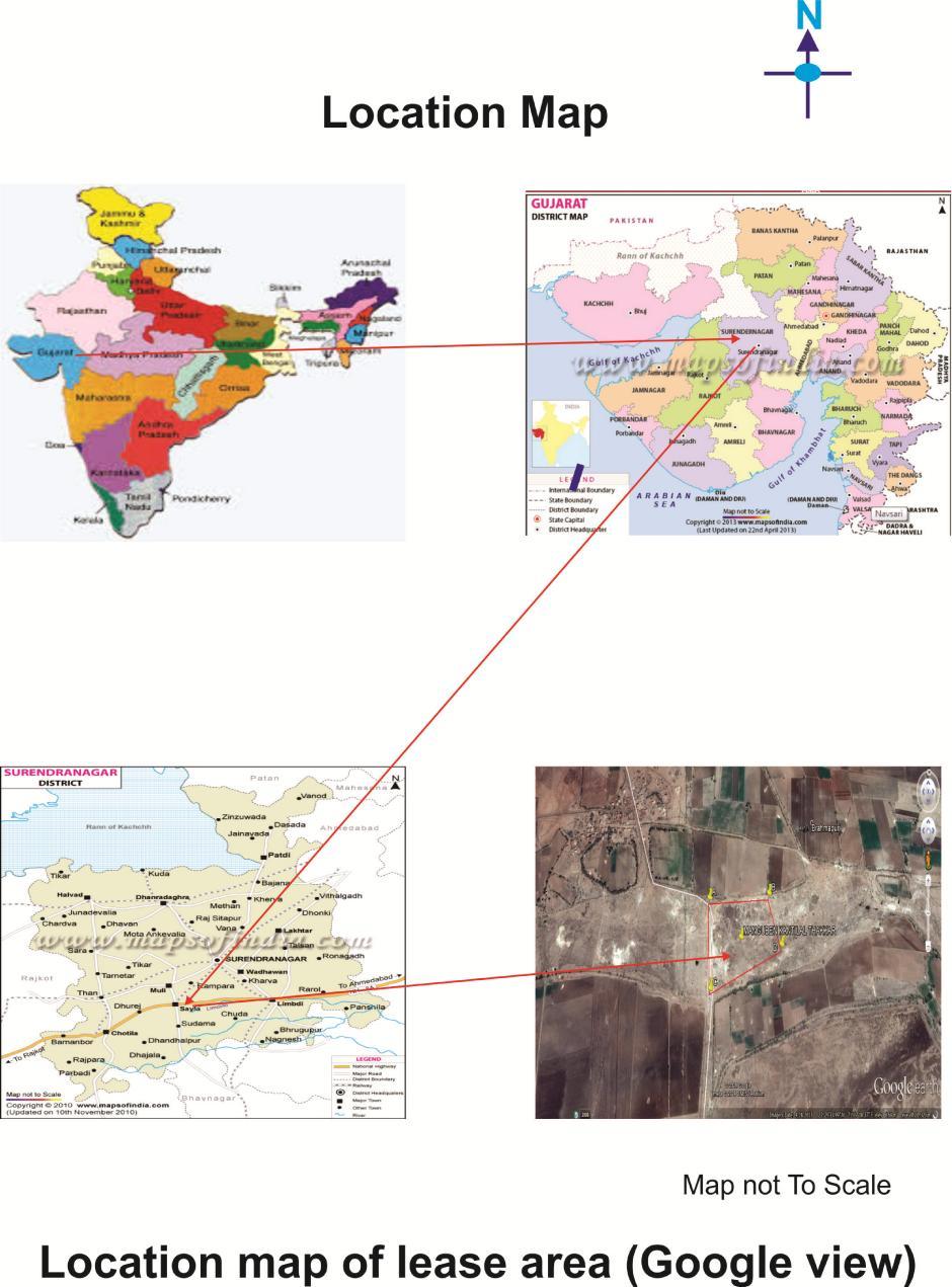
6 6
7 The geographical location of the project is as follows : Pillars Latitude (N) Longitude (E) A '40.00" '11.04" B '41.03" '19.20" C '33.03" '12.04" D '37.02" '21.03" 4.3 Details of alternate sites, considered and the basis of selecting the proposed site, particularly the environmental considerations gone into should be highlighted : This is to fulfil more requirement of Silica Sand demand arise. so,there is no significant impact on environment. 4.4 Size or magnitude of operation : "B" category manual and semi mechanized mining project. In this area the Silica Sand occurs in form of bed. The mineral reserves have been estimated by plan area method. 4.5 Project description with process details (a schematic diagram/flow chart showing the project layout, components of the project etc. is given below: The Silica Sand deposit in the area existing for mining occurs on the surface area. Manual opencast mining with the help of hammer is suitable for mining of such type of deposits. Silica Sand ore will be excavated by manual open cast method. Besides above, one low headwater pump will be also utilized for dewatering of working pits if necessary. Schematic diagram Open cast mining Site preparation 7
8 Fencing OB removal Digging ore by manual & Semi Mechanized Transported to the end use 4.6 Raw material required along with estimated quantity, likely source, marketing area of final products. Mode of transport of raw materials And finished products : N.A. 4.7 Resource optimization / recycling and reuse envisaged in the project. If any, should be briefly outlined : Resources are exploited optimistically, waste dumps will be reused for backfilling. 4.8 Availability of water its source, Energy/power requirement and source should be given : Water to prevent dust pollution and domestic consumption is about 4.21 KLD./day and the source is open well and tanker supply, no energy/power is required. The village nearby Brahmpuri is well electrified. 4.9 Quantity of wastes to generated (liquid and solid) and scheme for their Management/disposal : 4.10 Schematic representations of the feasibility drawing which give information of EIA purpose : According to MOEF mining project containing area 50 Ha. are considered in category B 2. Schematic representations of the feasibility is as under. Project Concept and Site selection 8
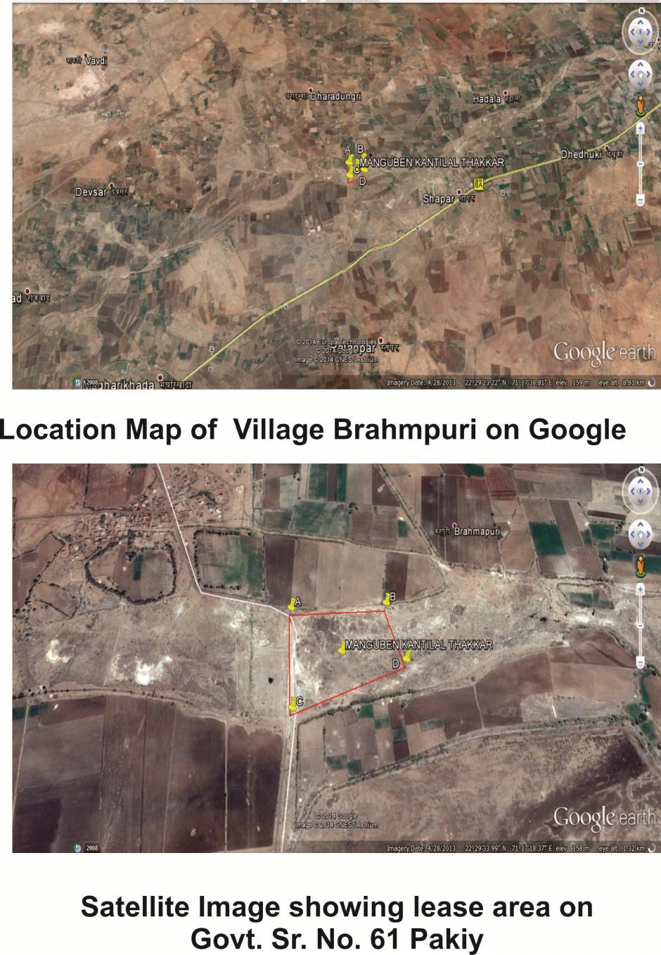
9 5.0 Site Analysis : 5.1 Connectivity : Form 1 pre-feasibility project report with proposed TOR to MOEF (EAC) Scoping by SEAC (site visit by sub group of SEAC, if necessary Category B 2 - EIA not required Appraisal and recommended by SEAC Approval by SEIAA Display on the SPCB/UTPCC website & project proponent website The mining lease area is about 0.50 km from village Brahmpuri approachable only by a tar road. The lease area is situated on Sayla Road. Brahmpuri can be approached from Sayla. Sayla is located National highway no. 8A Sayla is about km from lease area. Normally, the people around these parts avail autorickshaw, buses (transporting ore) for reaching Sayla. The nearest railway station is Than which is about km from Brahmpuri. The nearest airport is located at Rajkot, which is about km kms from Brahmpuri. The taluka headquarters is Sayla, which is about kms from Brahmpuri and Sayla is comparatively a bigger place than Brahmpuri and facilities of hospital, post and telegraph office etc. are also available. 5.2 Land Form - Land use and land Ownership : The lease area is Govt. waste land and non forest land and is granted for 20 years and applied for renewal further 20 years. 5.3 Topography (Google image) : The lease area is in irregular shape. Does no pit. The lease area consist of in survey no. 61 Paiky belong to Brahmpuri village. The area is almost flat area. 9
10 10
, CRZ.")
11 5.4 Existing land use pattern (agriculture, non -agriculture, forest, water bodies including area under CRZ), shortest distances from the periphery of the project to periphery of the forests, national park, wild life sanctuary, eco sensitive areas, water bodies (distance from the HFL of the river), CRZ. In case of notified industrial area, a copy of the Gazette notification should be given: Existing Land use pattern :- Agriculture lands and govt. wastelands cover the terrain surrounding ML area. Apart from this quite a number of mining leases are also found all around the ML. The ML area itself is confined to a government waste land very little part of the area has been mined out and mining is continuing from the existing quarry faces. Few plant are present in the area. Few bushes locally known as Ganda baval are seen. The detailed land use pattern is given. There is no reserve or protected forest within km periphery of lease area. Surface water bodies Map of Surendranagar :- 11

12 CRZ :- There is no CRZ within the km periphery of lease area. National park and wild life sanctuary :- There is no national park or wildlife sanctuary within the km periphery of lease area. 12


13 Eco sensitive areas :- There is no Eco sensitive zone within the km periphery of lease area. There is no notified industrial area within the km periphery of lease area. 5.5 Existing infrastructure : 1 Nearest railway station at Than is about km from site. 2 State Highway No. 119 is about 7.80 km from the lease area. 3 NH No.8A is about 1.50 km from the lease area. 5.6 Soil classification : Soil of the region falls within Average rain fall zone of mm. The soils are sandy loam, shallow depth reddish-black soils. 13


14 5.7 Climatic data from secondary sources : Sayla has a tropical climate. In winter there is much more rainfall in Sayla than in summer. According to Köppen and Geiger climate is classified as As. The average annual temperature in Sayla is 26.8 C. About 529 mm of precipitation falls annually. 1 Climate graph - Year Temperature graph - Year
 Town and country planning development authority classification : No industries and town planning programmers in the proposed area. 6.2 Population projection : No Human settlements near project area.")
15 3 Climate table - Year Social Infrastructure available : N.A. 6.0 Planning Brief : 6.1 Planning Concept (type of industries, facilities, transportation etc.) Town and country planning development authority classification : No industries and town planning programmers in the proposed area. 6.2 Population projection : No Human settlements near project area. 6.3 Land use planning (breakup along with green belt etc) : Details is given in land use pattern of approved mining plan. 6.4 Assessment of Infrastructure Demand (Physical & Social) : There is no large infrastructure demand near to proposed area. 6.5 Amenities / Facilities : Not applicable as it is a small project. 7.0 Proposed Infrastructure : 7.1 Industrial Area (processing Area) : --NA Residential Area (Non Processing Area) : --NA-- 15
16 7.3 Green Belt : The plant will follow the norms and will be in process to developing 33% green belt in lease area. 7.4 Social Infrastructure : N.A. 7.5 Connectivity (Traffic and Transportation Road/Rail/Metro/Water ways etc) : Well connected with Road/Rail. No metro and water ways. 7.6 Drinking Water Management (Source & Supply of water) : Drinking water is procured from open well existing nearby and 4.21 KLD. water tank is there for domestic and dust suppression purpose. 7.7 Sewage system : The domestic wastewater treat in the septic tank followed by soak pit. 7.8 Industrial waste management : --NA Solid waste management : --NA Power Requirement & Supply / Source : N.A. 8.0 Rehabilitation and Resettlement (R & R) Plan : Policy to be adopted (Central / State) in respect of the project affected persons including home outstees, land outstees and landless labourers (a brief outline to be given) : --NA Project Schedule & Cost Estimates : 9.1 Likely date of start of construction and likely date of completion (Time schedule for the project to be given) : It is an existing project and applied for Ec. 16
17 9.2 Estimated project cost along with analysis in terms of economic viability of the project : Project cost No. Particulars Amounts (Rs.) 1 Trolley based tractors 2,25,000/- 2 Tanker based tractors 2,00,000/- 3 Mining Equipments 50,000/- 4 Safety Equipments 25,000/- Total 5,00,000/ Analysis of proposal (Final Recommendation) : Financial and social benefits with special emphasis on the benefit to the local people including population, if any, in the area : This project has created employment potential for approximately about 15 to 20 local people. Thanks 17