PUBLIC NOTICE. Figure 8 Beach Homeowners Association, Inc. C/o: Mr. David Kellam (Administrator) 15 Bridge Road Wilmington, North Carolina 28411
|
|
|
- Miles Harris
- 5 years ago
- Views:
Transcription
 is releasing the Final Environmental Impact Statement (FEIS) for the Figure Eight Island Shoreline Management Project, and has received an")
1 US Army Corps Of Engineers Wilmington District PUBLIC NOTICE Issue Date: June 29, 2016 Comment Deadline: August 1, 2016 Corps Action ID Number: SAW All interested parties are herby advised that the Wilmington District, Corps of Engineers (Corps) is releasing the Final Environmental Impact Statement (FEIS) for the Figure Eight Island Shoreline Management Project, and has received an application from the Figure 8 Beach Homeowners Association, Inc. (HOA) requesting Department of the Army authorization to protect residential homes and infrastructures by installing a terminal groin structure along the southern shoulder of Rich Inlet and to conduct a supplemental beach nourishment on approximately 4,500 linear feet of oceanfront beach and 1,400 linear feet of back barrier shoreline on Figure Eight Island, in New Hanover County, North Carolina. Specific details and location information are described below and shown on the attached plan. The FEIS has been placed on our webpage, and can be found at click on Figure Eight Island Terminal Groin Project: Corps ID # SAW Applicant: Engineer Consultant: Figure 8 Beach Homeowners Association, Inc. C/o: Mr. David Kellam (Administrator) 15 Bridge Road Wilmington, North Carolina Coastal Planning & Engineering-NC, Inc. A Shaw Group Company C/o: Mr. Tom Jarrett 4038 Masonboro Loop Road Wilmington, North Carolina Authority The Corps evaluates this application and decides whether to issue, conditionally issue, or deny the proposed work pursuant to applicable procedures of the following Statutory Authorities: Section 404 of the Clean Water Act (33 U.S.C. 1344) Section 10 of the Rivers and Harbors Act of 1899 (33 U.S.C. 403) Section 103 of the Marine Protection, Research and Sanctuaries Act of 1972 (33 U.S.C. 1413) P a g e 1 7
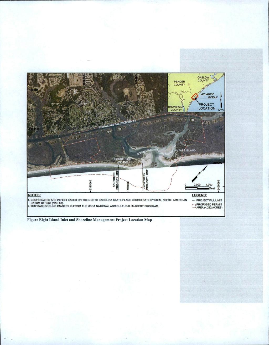
2 Location The project site is located on the northern portion of Figure Eight Island and within the Rich Inlet Complex, and will encompass approximately 4,500 linear feet of oceanfront shoreline, and 1,400 linear feet of back barrier shoreline on Figure Eight Island, New Hanover County, North Carolina. Nearest Towns: Wilmington and Wrightsville Beach Nearest Waterway: Atlantic Ocean, Nixon Channel, Green Channel, and the Intracoastal Waterway Latitude and Longitude: N, W Existing Site Conditions Figure Eight Island is an unincorporated privately developed island just north of Wrightsville Beach. It is bordered to the south by Mason Inlet and to the north by Rich Inlet, to the west by the Intracoastal Waterway, and to the east by the Atlantic Ocean. Rich Inlet and Nixon Channel is the established county boundary of New Hanover and Pender. The island is a typical barrier island that has undergone a variety of natural and anthropogenic changes. The majority of the residential island has been developed; and over two decades, authorization has been granted to the Figure 8 Beach HOA as well as individual property owners for various activities, such as dredging, sandbag installation, beach bulldozing, and shoreline nourishment, within waters of the U.S. Currently, there are (19) waterfront residential structures that are temporarily protected by sandbag revetments. Applicant s Stated Purpose Basic Purpose: The stated purpose of the project for this proposal is economics and to preserve the integrity of its infrastructure, to provide protection to existing development, and to ensure the continued recreational use of the oceanfront beach. Figure Eight Beach HOA has addressed the continuing oceanfront erosion problems associated with Rich Inlet and the Nixon Channel erosion hot-spot on the estuarine side of the island over the past several decades. Past actions to protect the shorelines have provided some protection, however they are seeking a longer term solution to handle shoreline erosion in order to protect the island s $907,352,900 (based on the 2012 reappraisal) assessed property tax value. Overall Purpose: The overall stated needs and objectives of the project are the following: 1) Reduce erosion along 2.34 miles of oceanfront and 1,400 linear feet of back barrier shorelines, 2) Provide reasonable short-term protection to residential structures to any unpredicted shoreline change over the next five years, 3) Provide long-term P a g e 2 7
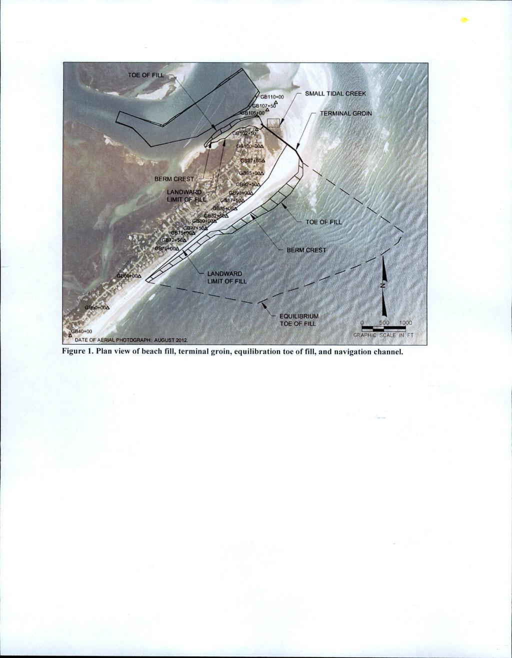
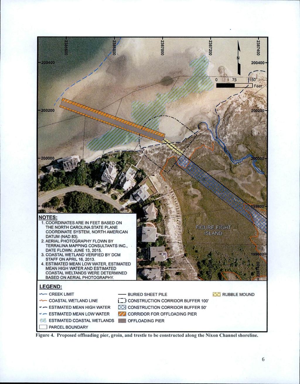
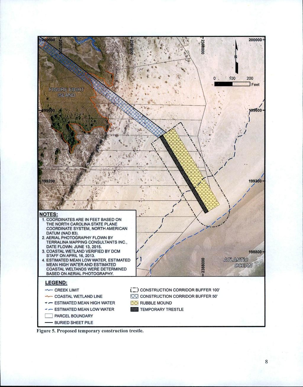
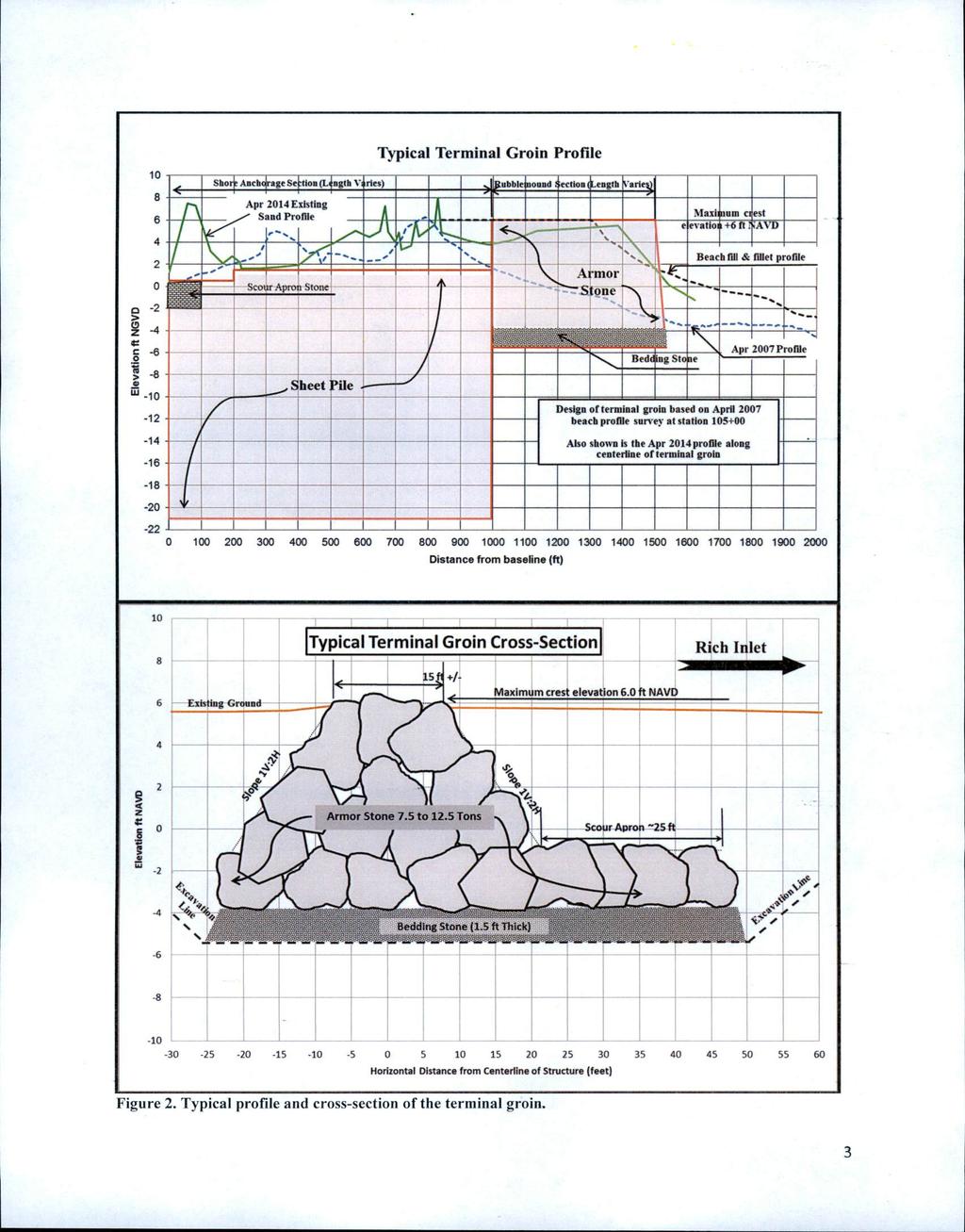
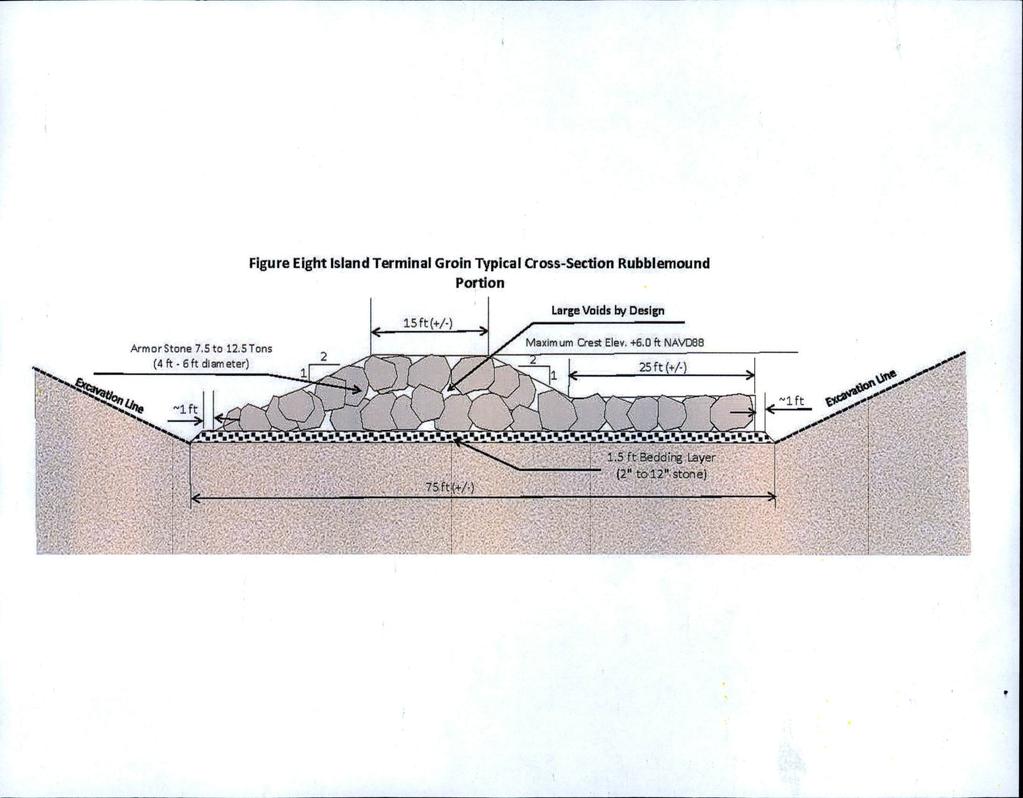
3 protection to homes and infrastructure over the next 30 years, 4) Maintain the tax value of homes, properties, and infrastructure, 5) Use beach compatible material, 6) Maintain navigation conditions within Rich Inlet and Nixon Channel, 7) Maintain recreational resources, and 8) Balance the needs of the human environment with the protection of existing natural resources. Project Description Within the Town s preferred alternative, known as Alternative 5D, the installation of the terminal groin is the main component in the protection of the oceanfront shoreline. The planned location of the proposed structure is along the southern shoulder of Rich Inlet and is just north of existing homes. Its total length is approximately 1,500 feet, which approximately 505 feet will project seaward of the 2007 mean high water shoreline (currently, this seaward end of the structure will terminate within the mean high water line and the mean low water line). The landward 995-foot anchor section would extend across the island and terminate near the Nixon Channel Shoreline. This anchor section will be constructed of 14,000 to 18,000 square feet of sheet pile, either metal or concrete, with approximately the last 100 feet of the anchor length wrapped with a 10-foot wide rubble scour protection apron, which will be installed at a depth of -2 feet NAVD. In general, the top elevation of the sheet pile will vary from +0.5 feet NAVD (or 6 inches below ground surface) for the first 200 linear feet on the landward (Nixon Channel shoreline) end to +1.5 feet NAVD over the remaining 795 linear feet. Although engineering design plans are not finalized, basic construction design of the seaward 505- foot part of the structure will be in the form of a typical rubble (rock) mound feature supported by a 1.5-foot thick stone foundation blanket. Top width is expected to be approximately 15 feet wide. Crest height or elevation of this section is estimated to be +6.0 feet NAVD for the first 400 feet, which is equivalent to the natural beach berm elevations, and would slope to a top elevation of +3.0 feet NAVD on the seaward end. If conditions show the footprint below the mean low water line at the time of construction, trucks may use a temporary trestle similar to the offloading dock or the rock material could be offloaded using a barge. Approximately 16,000 tons of stone would be used to construct the terminal groin. The concept design of the structure is intended to allow littoral sand transport to move over, around, and through the groin once the accretion fillet has completely filled in. Construction of the terminal groin will be kept within a corridor varying in width from 50 feet to 200 feet, with the 50 foot corridor being along the shore anchor section that will transect across the saltmarsh complex and the oceanfront primary dune system. For the seaward section, the construction would be restricted to a 200-foot corridor, a 100 feet on each side of the structure s footprint. A foot wide trench would be excavated to a depth of -5.5 feet NAVD in order to construct the foundation of this seaward rubblemound section. The approximate 8,000 cubic yards of excavated material will be replaced on and around the structure once it s in place. Plans are to barge the material for the terminal groin down the Atlantic Intracoastal Waterway (AIWW), through Nixon Channel, and either offloaded onto a temporary loading dock or directly onto shore. It P a g e 3 7
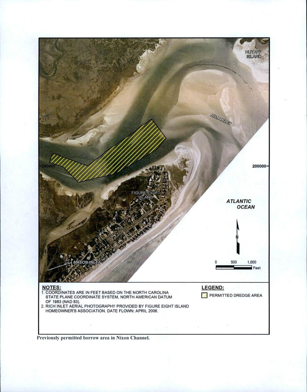
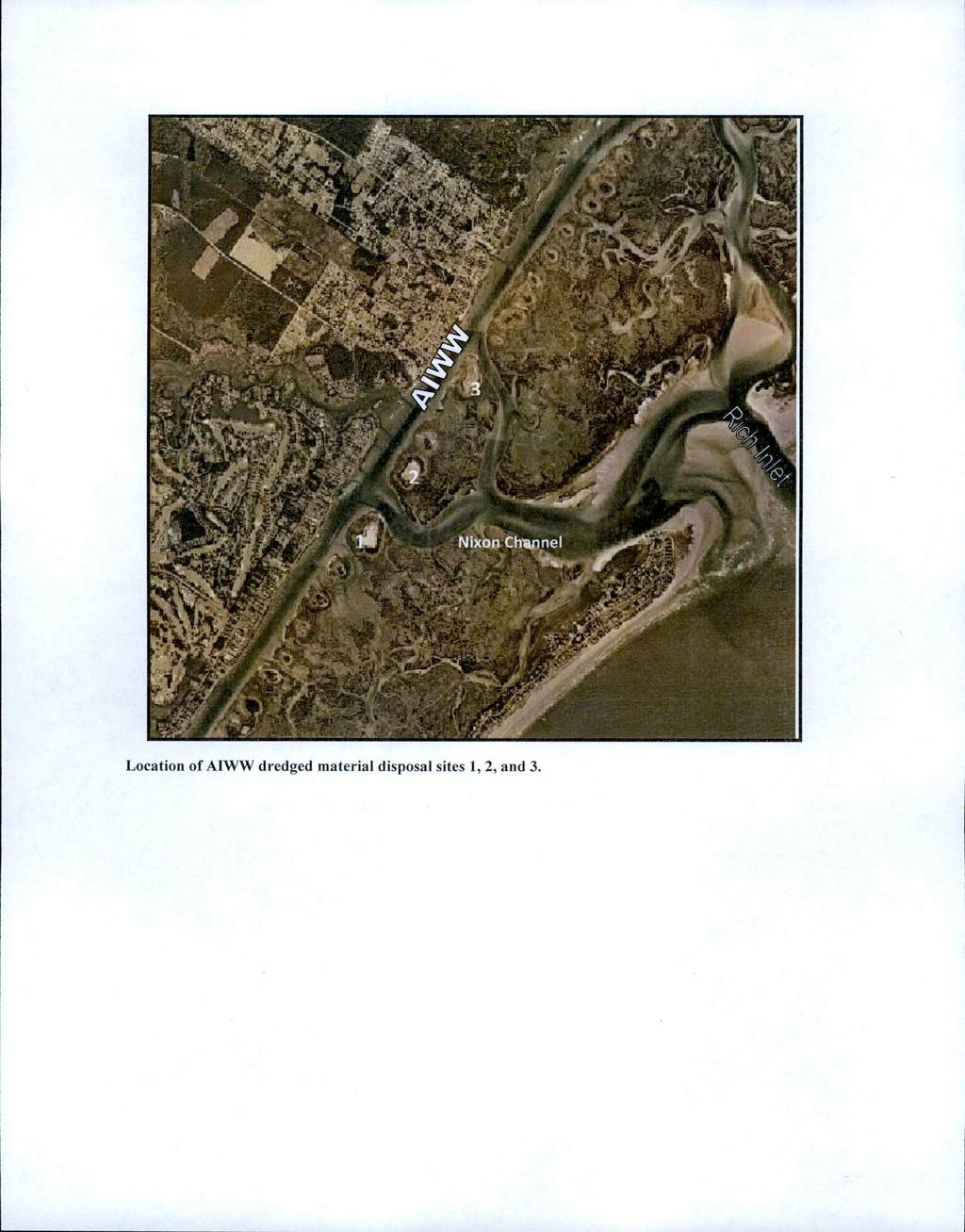
4 will then be transported, via dump trucks, within the designated corridor to the construction site. If a temporary loading dock is used, it will be elevated on pilings and would likely span from deep water to the dry beach shoreline. The dock would be approximately 20 feet wide with pilings spaced every 6 to 12 feet apart. Efforts will be taken to avoid, at the maximum extent practicable, the tidal marsh present within that location. The dock would span over any salt marsh vegetation that may be present at the time of construction. Material used for nourishment will be dredged using a hydraulic cutterhead plant within a designated borrow site within Nixon Channel, where approximately 830,000 cubic yard have been dredged for beach nourishment projects over the past 10 years. The dredging footprint in the channel area is approximately 25 acres in size and the target depth of dredging is feet NAVD (or -9 feet at mean low water). Approximately 294,500 cubic yards will be required for both the oceanfront (237,500 cubic yards) and the Nixon Channel shoreline (57,000 cubic yards) fill areas. Material would be transported via pipeline along an upland area located between the salt marsh and existing homes at the end of the island. This corridor has been used in previous renourishment events when dredging from the Nixon Channel borrow area. Beach compatible material from (3) upland disposal islands would serve as a contingency sediment source. Engineer modeling results have shown that periodic nourishment will be required approximately once every five years, or six separate maintenance events over a 30-year period, to maintain the beach and Nixon Channel shorelines. The combined 5-year estimated maintenance needs for both areas are 320,000 cubic yards of material under the 2006 shoreline conditions and 255,000 cubic yards of material under 2012 shoreline conditions, equivalent to approximately 58,000 and 45,000 cubic yards per year respectively. This material will come from the designated Nixon Channel borrow site and the (3) upland disposal areas. Plans shows that approximately 0.2 acres of coastal wetlands exists within the nourishment footprint along the Nixon Channel shoreline and would be covered by the dredged material. This stand of vegetated Spartina alterniflora was first established in 2009 and has spread since that time. Also, the anchor section of the terminal groin is expected to impact approximately 0.34 acres of coastal wetlands by the installation of the sheet piling and by the use of equipment transporting construction material. The sheet pilings will be pile driven 0.5 feet below the surface as to not interfere with tidal exchanges and the transport of material would be kept within a 50-foot corridor. Additionally, mats will be utilized to reduce impacts to the marsh substrate. Avoidance and Minimization The FEIS examines potential impacts and includes a comprehensive avoidance and minimization discussion of specific design measures and monitoring that is being proposed to help minimize potential impacts and to evaluate unforeseen effects of the project. Several of the measures include limiting the construction activity from P a g e 4 7
5 November 16 to March 31 when biological activity is at its lowest and to avoid sea turtle nesting season; use of hydraulic cutterhead dredge; use of sheet piles through the coastal marsh section to reduce the footprint and piles will be driven below the marsh surface approximately 0.5 feet (or 6 inches) in order to provide continual tidal exchange; restricting work for the terminal groin construction within a 50-foot corridor for approximately 995 feet of the anchor section that transects the salt marsh and dune communities and a 200 foot corridor for seaward section and anchor section at Nixon Channel shoreline; use of construction mats within the marsh habitat to reduce rutting; reduction of beach fill along Nixon Channel shoreline to avoid the tidal finger located in the northern part of Figure Eight Island spit; use of beach compatible material and during construction sampling to ensure compatibility with the NC State Sediment Criteria requirements; coordinated placement of pipeline to reduce impacts to overwintering piping plover habitat; continual monitoring for seabeach amaranth, sea turtles, and birds; during construction monitoring for manatee; post construction aerial habitat mapping for 3 years to monitoring levels of potential habitat changes; and the implementation of a long-term shoreline management plan to monitor the terminal groin structure s effects on the surrounding shorelines (up to 30 years). Essential Fish Habitat Pursuant to the Magnuson-Stevens Fishery Conservation and Management Act, the Corps initiated Essential Fish Habitat (EFH) consultation and submitted an EFH Assessment to the National Marines Fisheries Service (NMFS) Habitat Conservation Division for review. By letter dated May 6, 2016, NMFS concluded their consultation by not requiring additional conservation measures from those disclosed in Chapter 6 of the EIS. Cultural Resources Coordination with the State Historic Preservation Office (SHPO) has occurred during the development of the project for compliance with the National Historic Preservation Act. A cultural resource survey, with emphasis on the wreck Wild Dayrell, was conducted within the Rich Inlet complex and provided to SHPO. Construction, both dredging and groin installation, has been designed to avoid the known wreck and notification procedures to SHPO are proposed if work encounters unknown sites during operations. Endangered Species Pursuant to Section 7 of the Endangered Species Act of 1973, the Corps has requested the initiation of formal consultation with the U.S. Fish and Wildlife Service (USFWS) and the NMFS Protected Resources Division due to the presence of specific species listed as threatened or endangered and their critical habitat (CH) within the project area. A Biological Assessment, which included an effects determination to those specific species and CH, was provided to both agencies by letter dated December 11, Consultation P a g e 5 7
6 with the resource agencies is on-going and no permit decision will be made until consultation under the ESA has been concluded. Other Required Authorizations The Corps forwards this notice and all applicable application materials to the appropriate State agencies for review. North Carolina Division of Water Resources (NCDWR): The Corps will generally not make a final permit decision until the NCDWR issues, denies, or waives the state Certification as required by Section 401 of the Clean Water Act (PL ). At this time, the applicant has not submitted an application to the NCDWR Central Office in Raleigh for a 401 Certification. North Carolina Division of Coastal Management (NCDCM): The application did not include a certification that the proposed work complies with and would be conducted in a manner that is consistent with the approved North Carolina Coastal Zone Management Program. Pursuant to 33 CFR (b)(2) the Corps cannot issue a Department of Army (DA) permit for the proposed work until the applicant submits such a certification to the Corps and the NCDCM, and the NCDCM notifies the Corps that it concurs with the applicant s consistency certification. As the application did not include the consistency certification, the Corps will request, upon receipt, concurrence or objection from the NCDCM. It should be noted that the Corps has coordinated closely with DCM in the development of the EIS to ensure the process complies with the State Environmental Policy Act (SEPA) requirements, as well as the NEPA requirements. The Final EIS has been designed to consolidate both NEPA and SEPA processes to eliminate duplications. State Clearinghouse: The Corps submitted the EIS document to the North Carolina Department of Administration, State Clearinghouse Office on June 29, 2016 for compliance with SEPA. Evaluation The decision whether to issue a permit will be based on an evaluation of the probable impacts including cumulative impacts of the proposed activity on the public interest. That decision will reflect the national concern for both protection and utilization of important resources. The benefit which reasonably may be expected to accrue from the proposal must be balanced against its reasonably foreseeable detriments. All factors which may be relevant to the proposal will be considered including the cumulative effects thereof; among those are conservation, economics, aesthetics, general environmental P a g e 6 7
7 concerns, wetlands, historic properties, fish and wildlife values, flood hazards, flood plain values (in accordance with Executive Order 11988), land use, navigation, shoreline erosion and accretion, recreation, water supply and conservation, water quality, energy needs, safety, food and fiber production, mineral needs, considerations of property ownership, and, in general, the needs and welfare of the people. For activities involving the discharge of dredged or fill materials in waters of the United States, the evaluation of the impact of the activity on the public interest will include application of the Environmental Protection Agency s 404(b)(1) guidelines. Commenting Information The Corps of Engineers is soliciting comments from the public; Federal, State and local agencies and officials, including any consolidated State Viewpoint or written position of the Governor; Indian Tribes and other interested parties in order to consider and evaluate the impacts of this proposed activity. Any comments received will be considered by the Corps of Engineers to determine whether to issue, modify, condition or deny a permit for this proposal. To make this decision, comments are used to assess impacts on endangered species, historic properties, water quality, general environmental effects and the other public interest factors listed above. Comments will be used in the preparation of the Record of Decision (ROD) pursuant to the National Environmental Policy Act (NEPA). Comments are also used to determine the need for an additional public hearing and to determine the overall public interest of the proposed activity. Any person may request, in writing, within the comment period specified in this notice, that a public hearing be held to consider the application. Requests for public hearings shall state, with particularity, the reasons for holding a public hearing. Requests for a public hearing shall be granted, unless the District Engineer determines that the issues raised are insubstantial or there is otherwise no valid interest to be served by a third hearing. Written comments pertinent to the proposed work and/or FEIS, as outlined above, will be received by the Corps of Engineers, Wilmington District, until 5pm, August 1, Comments should be submitted to Mr. Mickey Sugg, 69 Darlington Avenue, Wilmington, North Carolina or sent by at mickey.t.sugg@usace.army.mil. If you have questions, please contact Mr. Sugg at (910) P a g e 7 7
8
9
10
11
12
13
14
15
16
17
18
19
20
21