The F.O.R.C.E. The Future Of Redwood Creek Environment
|
|
|
- Nigel Woods
- 5 years ago
- Views:
Transcription
1 The F.O.R.C.E. The Future Of Redwood Creek Environment Robert Andersen Katelyn Csatari Achyuth Madabhushi Julie Swanson
2 Overview Mission Statement Watershed Characterization Land and Water Use History Governance Organizations Problems Solutions Problem 1 Problem 2 Community Outreach Conclusion
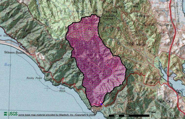
3 Introduction The Redwood Creek watershed is located in Marin County, California. The creek runs through an enormous redwood forest and is at the crux of several conservation efforts.
4 Mission Statement The F.O.R.C.E. s goal is to reduce turbidity by 10%, increase the dissolved oxygen content to 5 mg/l, restore the function of the floodplain, and increase the Coho salmon population by 20% by the year 2030 in the Redwood Creek, Marin County. We also hope to engage the community in an educational program for the watershed by 2020.
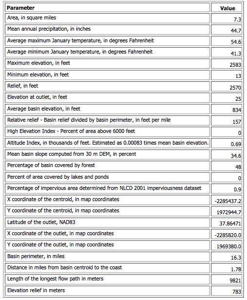
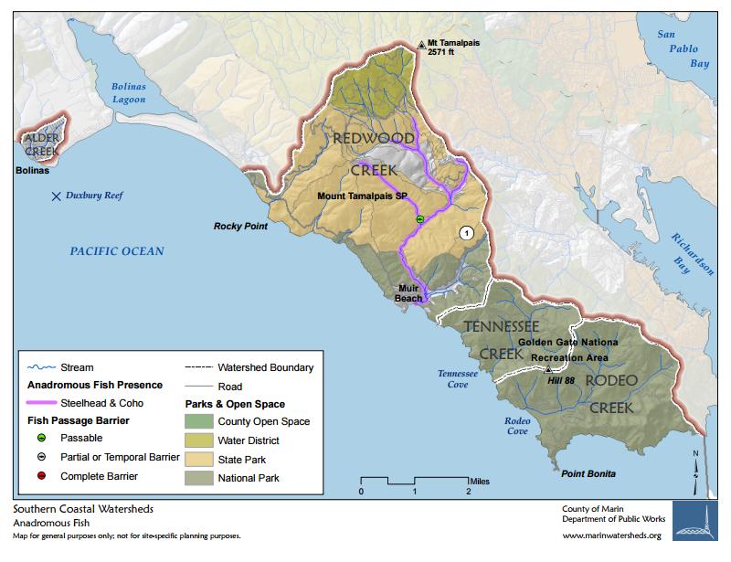
5 Watershed Characterization Drainage area: 7.3 sq. miles Redwood Creek Length: 4.7 miles Potential Habitat: 6.8 miles of streams Vegetation: 31% Coniferous, 32% Shrubland, 18% Riparian,12% Grassland Source: Mount Tamalpais Discharge: Pacific Ocean at Muir Beach Main Tributaries: Bootjack, Fern, Kent Canyon, Rattlesnake and Spike Buck Creeks
6
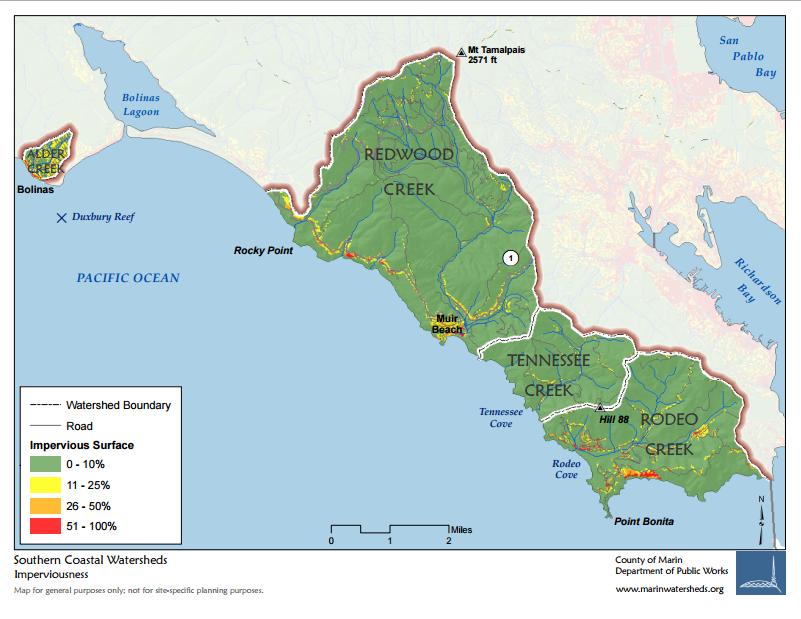
7 Land and Water Use 95% of land is in public ownership; 5% is in private ownership Three private communities occupy a small portion: Green Gulch Farm, Muir Woods Park, Muir Beach Community Dominant Land Use: Recreational Within the watershed boundaries: Mt. Tamalpais State Park, National Park Service Lands: Muir Woods National Monument, portions of Golden Gate Recreational Area Variety of habitat types: coastal chaparral, grasslands, old-growth redwood forest, mixed hardwood forest, seasonal wetlands, riparian wetlands
8

9

10 History of the Watershed Before European colonization, primarily agricultural land inhabited by a local tribe After European colonization, the area attracted many farmers and construction along the creek took place. It has become a major tourist attraction in the area. Unnaturally straight stream Poor flow Loss of riparian vegetation Weak habitats for salmon and trout Invasive plants and animals Increased flooding Currently primarily used for recreation


11 Governance Organizations Marin Municipal Water District National Park Service California Department of Fish and Wildlife
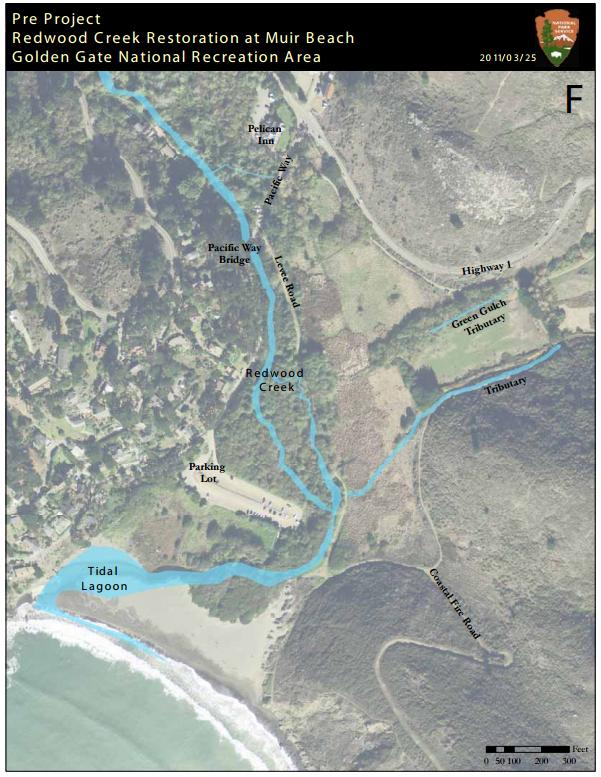
12 Problems 1. Problem Description Aquatic and Riparian Habitat Quality Coho salmon are state and federally listed as endangered. Steelhead trout and California red-legged frogs threatened. Abundant invasive species present. 2. Sediment Impairment and Flood Control Construction features in recent years have confined the creek flow and influenced sediment transport. A visitor parking lot and footbridge are currently located in the center of the floodplain, which eliminates the function of the floodplain.


13 This is an image in the Redwood Creek in Muir Woods National Monument. It shows an excellent example of what we would like the entire creek to be like. It is an ideal habitat for salmon. This is an image of the current condition of the Redwood Creek Watershed. Improving the estuaries would provide a nurturing habitat for fish prior to their journey out to the ocean.
 Population-based action: Captive rearing is a temporary measure to mature infant salmon.")
14 Solutions Problem Solution Solution 1 Habitat-based action: Implement restoration designs specific to coho salmon and steelhead trout habitats (side channels, large woody debris, removal of instream fish barriers) Population-based action: Captive rearing is a temporary measure to mature infant salmon. Once mature, they will be released.
15 Solutions Problem 2 Solution Solution Solution Install erosion control Removal of visitor parking techniques: use rice straw lot and undersized Implement an wattles to create contours on footbridge that consume the elevated emergency banks that direct water flow floodplain. access road and into creek and reduce Implementation of a new hiking trail with a downslope sediment delivery. footbridge that will cross sloped drainage Add vegetation to sloped creek and floodplain. area on either sides drainage area in an effort Addition of parking lot to deal with flooding produces roots and adds located outside of during winter rains. integrity to the soil preventing floodplain. future erosion.


16 New access road and hiking trail. Elevation and drainage areas keep road from flooding Reestablishing roots secures soils and reduces erosion. The contours create a pathway that leads rainfall to creek. This will restore the capacity of the creek and help with the productivity of the creek habitat.

17 Community Outreach Solution Implement an educational hiking trail around key components of the watershed, highlighting the importance of watershed and the restoration efforts taking place. Some interactive educational hiking posts include: Information about the Coho salmon and their extinction Invasive species along the creek Heavy erosion spots Current restoration efforts There is already a coastal trail in place near Muir beach so we hope to add these posts along that trail. There is also many trails within the Muir Woods National Monument.
18 Conclusion Reducing turbidity and increasing dissolved oxygen content will improve overall creek water quality. Restoring the function of the floodplain will decrease erosion on the banks of the creek. Habitat-based solution will increase the population of coho salmon in the creek by 20 % by the year 2030
19 References County of Marin. "Southern Coastal Creeks Watershed." Marin County Watershed Program. Marin County Department of Public Works, n.d. Web. 07 Apr Bay Area Integrated Regional Watershed Management Plan. "Redwood Creek Restoration at Muir Beach, Phase 5." Bay Area IRWMP. Golden Gate National Parks Conservancy, n.d. Web. 07 Apr NOAA. "Redwood Creek Recovery Planning." (n.d.): n. pag. West Coast Fisheries. NOAA, Sept Web. 6 Apr State of California. "Redwood Creek Coho Salmon Rescue and Captive Rearing Project." California Department of Fish and Wildlife, n.d. Web. 07 Apr United States National Park Service. "Redwood Creek Restoration at Muir Beach." National Parks Service. U.S. Department of the Interior, n.d. Web. 07 Apr The Nature Conservancy. "Redwood Creek (Marin County)." California Salmon Snapshots. N.p., n.d. Web. 07 Apr State of California. Marin Watershed Management Area Overview (n.d.): n. pag. State Water Resources Control Board, Nov Web. 7 Apr
20 References United States National Park Service. "Environmental Assessment Lower Redwood Creek Interim Flood Reduction Measures and Floodplain / Channel Restoration." (n. d.): n. pag. Klamath Resource Information System. Web. 7 Apr United States National Park Service. "Captive Rearing of Redwood Creek Coho Salmon." U.S. Department of the Interior, n.d. Web. 7 Apr Hofstra, Terrence D., and David G. Anderson. "Survey Of Salmanoid Fish And Their Habitat Redwood Creek, Marin County, California." (n.d.): n. pag. Redwood National Park Technical Services Division, Apr Web. 7 Apr