A REPORT TO MADISON BROCK LIMITED PHASE ONE ENVIRONMENTAL SITE ASSESSMENT PROPOSED RESIDENTIAL DEVELOPMENT 2480, 2490 AND 2510 BROCK ROAD
|
|
|
- Harriet Posy Dean
- 5 years ago
- Views:
Transcription
1 A REPORT TO MADISON BROCK LIMITED PHASE ONE ENVIRONMENTAL SITE ASSESSMENT PROPOSED RESIDENTIAL DEVELOPMENT 2480, 2490 AND 2510 BROCK ROAD CITY OF PICKERING Reference No E057 June 7, 2017 DISTRIBUTION 3 Copies - Madison Brock Limited
2 Reference No E057 i LIMITATIONS OF LIABILITY This report was prepared by Soil Engineers Ltd. for the account of the Madison Brock Limited and for review by its designated agents and financial institutions and government agencies. Use of the report is subject to the conditions and limitations of the contractual agreement. The material in it reflects the judgement of Samiya Tabassum, M.Env.Sc., Samuel Lee, B.Sc., and Eleni Girma Beyene, P. Eng., in light of the information available to it at the time of preparation. Any use which a Third Party makes of this report, and/or any reliance on decisions to be made based on it, are the responsibility of such Third Parties. Soil Engineers Ltd. accepts no responsibility for damages, if any, suffered by any Third Party as a result of decisions made or actions based on this report. One must understand that the mandate of Soil Engineers Ltd. is to obtain readily available past and present information pertinent to the subject site for a phase one environmental assessment only. No other warranty or representation, expressed or implied, as to the accuracy of the information is included or intended by this assessment. Site conditions, environmental or otherwise, are not static and this report documents site conditions observed at the time of the site reconnaissance. It should be noted that the information supplied in this report is not sufficient to obtain approval for disposal of excess soil or materials generated during construction.
3 Reference No E057 ii TABLE OF CONTENTS 1.0 EXECUTIVE SUMMARY INTRODUCTION Phase One Property Information Contact Information SCOPE OF INVESTIGATION RECORDS REVIEW General...5 (i) Phase One Study Area...5 (ii) First Developed Use...5 (iii) Fire Insurance Plans...5 (iv) Chain of Title...6 (v) Environmental Reports Environmental Source Information...7 (i) Ministry of the Environment...7 (ii) Environment Canada...9 (iii) Other Sources Physical Setting Sources...13 (i) Aerial Photographs...13 (ii) Topography, Hydrology, Geology...14 (iii) Fill Materials...15 (iv) Water Bodies and Areas of Natural Significance...15 (v) Well Records Occupancy Search Records Review Summary INTERVIEWS SITE RECONNAISSANCE General Specific Observations at Phase One Property...20 (i) Building Inspection...20 (ii) Hazardous Materials...20 (iii) Underground Storage Tanks...20 (iv) Above-Ground Storage Tanks...20 (v) Substance Containers...20
4 Reference No E057 iii TABLE OF CONTENTS (Cont'd) (vi) Waste Management and Maintenance Practices...21 (vii) Air Quality and Noise...21 (viii) Water Wells...21 (ix) Phase One Study Area Inspection...21 (x) Enhanced Property Investigation Summary of Site Reconnaissance REVIEW AND EVALUATION OF INFORMATION Current and Past Uses Discussion of Environmental Items...23 (i) Potentially Contaminating Activity Classification Areas of Potential Environmental Concern Phase One Conceptual Site Model CONCLUSIONS Phase Two Assessment Recommendation RSC Requirements ESA, Body of Water, ANSI O. Reg. 511/09 and Fill Legal Requirements REFERENCES...31
5 Reference No E057 iv DRAWINGS Site Location Plan... Drawing No. 1 Property Index Map... Drawing No Historical Map... Drawing No Ontario Base Map... Drawing No. 4 Topographic Map... Drawing No. 5 Surface Geology Map... Drawing No. 6 Bedrock Geology Map... Drawing No. 7 Watershed Map... Drawing No. 8 Area of Natural Features and Protection Area Plan... Drawing No. 9 Phase One Conceptual Site Model... Drawing No. 10 APPENDICES Ownership History... Freedom of Information (FOI)... Ecolog ERIS Report... Aerial Photographs... MOECC Well Records... Occupancy Search... Site Photographs... Table of Current and Past Uses... Property Survey Plan... Appendix A Appendix B Appendix C Appendix D Appendix E Appendix F Appendix G Appendix H Appendix I
6 1 Reference No E EXECUTIVE SUMMARY Soil Engineers Ltd. was retained to carry out a Phase One Environmental Site Assessment (Phase One ESA) at 2480, 2490 and 2510 Brock Road, in the City of Pickering. The purpose of the study was to identify any potential environmental liability associated with the subject site. The findings from our research of documents pertaining to the site, interviews with persons knowledgeable of the site, and an environmental site reconnaissance, together with our assessment, are presented in this Report. The subject site was mainly used for agricultural purposes from 1870s to 1970s. From 1970s to 2011, the northern section of the subject site was used as a golf course and the southern section was occupied by a landscape materials supply company, and then a vacant lot under construction since The neighbouring properties in the Phase One Study Area consisted of commercial properties to the north and east beyond Brock Road, and vacant properties to the south and west of the subject site. The Phase One ESA has revealed the following items of environmental concern attendant to the subject site: Potential use of pesticides at the former golf course which occupied the northern section of the subject site. Former equipment and vehicles storage by the former landscape materials supply company on the southwestern section of the subject site. Presence of fill materials at the majority of the subject site, based on the geotechnical drilling investigation. It is recommended that a Phase Two ESA be conducted to assess the above concerns.
7 2 Reference No E INTRODUCTION 2.1 Phase One Property Information Soil Engineers Ltd. has carried out a Phase One Environmental Site Assessment (Phase One ESA), as defined by the Environmental Protection Act (EPA), Ontario Regulation (O. Reg.) 153/04, as amended by O. Reg. 366/05, 66/08,511/09, 179/11 and 269/11, hereinafter referred to as O. Reg. 153/04. The Phase One Property, as shown on the Site Location Plan, Drawing No. 1, is located at the west side of Brock Road, approximately 165 m south of the intersection at Brock Road and Dersan Street in the City of Pickering. It has the municipal address of 2480, 2490 and 2510 Brock Road. The subject site consists of two (2) parcels, and the Property Identification Numbers (PINs) are and , as shown on the Property Index Map, Drawing No. 2. The subject site is a former part of Lot 19, Concession 3, City of Pickering, Regional Municipality of Durham. The PINs and the property descriptions from the parcel register are given in the table below: PIN Municipal Address Description and 2490 Brock Road PART OF LOT 19, CONCESSION 3, PICKERING, PARTS 2, 3, 4 AND 5 PLAN 40R26764; SUBJECT TO AN EASEMENT IN GROSS OVER 6 & 7 PLAN 40R AS IN DR ; SUBJECT TO AN EASEMENT IN GROSS OVER PARTS 7 & 9 PLAN 40R28759 AS IN DR ; CITY OF PICKERING Brock Road PT LTS 19 CON 3 PICKERING; SUBJECT TO AN EASEMENT IN GROSS OVER PART 4 PLAN 40R28759 AS IN DR ; CITY OF PICKERING No information was available for review on the Tax Assessment Roll Number of the subject site.
8 3 Reference No E057 3 The subject site is irregular in shape, encompassing an approximate area of 3.9 ha (9.6 ac). The UTM coordinates for the approximate centroid of the subject site are m E and m N as obtained from Google Earth which utilizes a 1983 North American Datum, zoned as 17 T. 2.2 Contact Information This Phase One ESA was commissioned in accordance with our proposal dated March 15, 2017, as approved on March 16, 2017 by Christian Lamanna, of Madison Brock Limited. Our client and the property owner of the subject site can be contacted at: Madison Brock Limited 369 Rimrock Road Toronto, Ontario M3J 3G2 Attention: Christian Lamanna
9 4 Reference No E SCOPE OF INVESTIGATION The general objectives of a Phase One ESA, as defined by Part VII of O. Reg. 154/04 of the EPA, are the following: To develop a preliminary determination of the likelihood that one or more contaminants have affected any land or water on, in or under the Phase One Property. To determine the need for a Phase Two ESA. To provide a basis for carrying out any required Phase Two ESA. To provide adequate preliminary information about environmental conditions in the land or water on, in or under the phase one property for the conduct of a risk assessment following completion of a Phase Two ESA. A Phase One ESA generally consists of the following components: A records review. Interviews. Site reconnaissance. An evaluation of the information gathered from the records review, interviews and site reconnaissance. Completion of a Phase One Environmental Site Assessment report. The submission of the Phase One Environmental Assessment report to the commissioner of the report. A residential development is being proposed for the subject site. It is anticipated that the new development will be provided with municipal services and roadways meeting urban standards. A Property Survey Plan for the subject site is included in Appendix I.
10 5 Reference No E RECORDS REVIEW 4.1 General (i) Phase One Study Area Except where noted, the Phase One Study Area generally consists of the subject site plus 250 m beyond the perimeter boundaries of the subject site. (ii) First Developed Use The first developed use of a site is defined by O. Reg. 153/04 as the earlier of either the first use in or after 1875 that resulted in the development of a building or structure on the property, or the first potentially contaminating use or activity on the Phase One Property. A Historical Map drafted in 1877 was located on March 24, 2017 at McGill Digital Atlas Library Website. A copy of the map is presented on Drawing No. 3, showing the subject site was part of the estate owned by W. Knox in Given the size and shape of the estate, the first developed use appears to have been as farmland. (iii) Fire Insurance Plans During the years researched, the site was always used for agricultural purposes. Plans and Fire Insurance Maps were last published by CGI Information Systems and Management Consultants Inc. in the mid-1970s and did not cover agricultural areas. Therefore, no information pertaining to this site was requested.
11 6 Reference No E057 6 (iv) Chain of Title A land title search was conducted for the subject site at the Region of Durham Land Registry Office on March 22, The information from the Parcel Register and Land Title research site is listed in Appendix A. The earliest records show that the site was part of the (200 ac) estate known as Lot 19, in the 3 rd Concession, patented to John Elmsley by the Crown in Throughout the years, the ownership of the property changed several times between private individuals and businesses. The latest transaction for the subject site occurred in 2017, when the Corporation of the City of Pickering transferred the subject site to Madison Brock Limited, the current registered owner. (v) Environmental Reports Soil Engineers Ltd. is not aware of any prior environmental reports for the subject site.
12 7 Reference No E Environmental Source Information (i) Ministry of the Environment Waste Disposal Sites Active and closed landfill sites located in excess of 1 km from the subject site are considered to have no significant potential for environmental impact on the subject site. On March 24, 2017, Soil Engineers Ltd. reviewed the Ontario Ministry of the Environment (MOE) Waste Disposal Site Inventory, dated June A closed waste disposal site was located 550 m west of the subject site. Industrial Sites Producing or Using Coal Tar and Related Tars in Ontario Soil Engineers Ltd. reviewed the MOE Inventory of Industrial Sites Producing or Using Coal Tar and Related Tars in Ontario, dated November 1988, and the Inventory of Coal Gasification Plant Waste Sites in Ontario, dated April 1987 on March 23, There were no records of coal gasification plants, coal tar distillation plants, creosote plants, etc., at or within the vicinity of the subject site. All facilities of this nature are located in excess of 1 km from the subject site and are considered to have no significant potential for environmental impact on the subject site. PCB Waste Storage Sites The MOE Ontario Inventory of PCB Storage Sites, dated 2000, was reviewed on March 23, The subject site is not listed as a PCB waste storage site, and no PCB waste disposal sites are located at any of the neighbouring properties within the Phase One Study Area.
13 8 Reference No E057 8 MOE Waste Generator On March 23, 2017, the MOE Waste Generator Registration database files, dated 2000, 2007, 2008, 2013 and 2015 were reviewed. The subject site and following neighbouring property were listed as waste generators under Regulation 558 of the EPA as given in the table below: Years 2000, 2007, 2008, 2013 and 2015 Generator Number ON , 2008 ON Generator Name Mount Pleasant Group of Cemeteries 2505 Brock Road North T. Arnts Loam Supply Ltd Brock Road North Distance from the Subject Site Waste Class 40 m east Waste Oils & Lubricants Adjacent property to the south 212 Aliphatic Solvents and Residues Waste Oils & Lubricants Records of Site Condition On March 23 and 24, 2017, the MOE public Brownfields Environmental Site Registry was checked for records of site condition filed for properties within 1.0 km of the centroid of the subject site. There was one RSC filed within the Phase One Study Area. The RSC was filed under File No for 2580 Brock Road, approximately 180 m north of the subject site. A Phase One and Two ESA were completed for the property, and no remediation or risk assessment work was recorded. MOE Freedom of Information A request for documented environmental concerns and citations pertaining to the subject site was forwarded to the MOE Freedom of Information Office on May 1, No response had been received at the time of writing this report. In the event that their response suggests cause for concern, it will be forwarded together with an assessment of its significance. A copy of the FOI has been included in Appendix B.
14 9 Reference No E057 9 (ii) Environment Canada National Pollutant Release Inventory On March 27, 2017, the Environment Canada National Pollutant Release Inventory (NPRI) database files were reviewed. The subject site is not registered in the NPRI database. In addition, no properties within the Phase One Study Area are listed in the NPRI database. National PCB Inventory On March 27, 2017, the Environment Canada PCB Inventory database files, dated 1994, were reviewed. The site is not registered in the National PCB Inventory database. In addition, no properties within the Phase One Study Area are listed in the database. (iii) Other Sources Municipal Freedom of Information A request for documented environmental concerns and citations pertaining to the subject site was forwarded to the City of Pickering on May 2, No response had been received at the time of writing this report. In the event that their response suggests cause for concern, it will be forwarded together with an assessment of its significance. A copy of the FOI has been included in Appendix B. Technical Standards & Safety Authority The use of underground storage tanks (USTs) containing petroleum products is regulated in Ontario by the Ministry of Consumer and Commercial Relations (MCCR) under various legislative instruments, including the Gasoline Handling
15 10 Reference No E Act and Energy Act. Above ground and underground storage tanks that contain petroleum product are required by law to be registered with the MCCR, and the Technical Standards & Safety Authority (TSSA) is responsible for keeping record of these tanks. Customer Services of the TSSA was contacted on March 28, 2017 regarding possible registration, size and age of USTs and ASTs on the subject site and adjacent properties. They informed us that no USTs or ASTs were registered for the subject site and adjacent properties. It should be noted that reliable TSSA records date from 1987 to the present. Environmental Risk Assessment Service (ERIS) Ltd. ERIS Ltd. provides reports that compile information from both government and private databases of interest to the environmental field. The ERIS report prepared for the Phase One Property (Order no , dated March 22, 2017) can be found in Appendix C. The database and number of records found pertaining to the subject site and Phase One Study Area are listed in the table below. Database Number of Records for Phase One Property Number of Records for Phase One Study Area Certificates of Approval (CA) 0 2 Ontario Regulation 347 Waste 0 13 Generators Summary (GEN) Record of Site Condition (RSC) 0 1 Ontario Spills (SPL) 0 22 Water Well Information System (WWIS) 2 13 The records pertaining to the Phase One Property and its upstream neighbouring properties are briefly discussed in the following sections. Certificates of Approval (CA) This database contains the following types of approvals: Air & Noise, Industrial Sewage, Municipal & Private Sewage, Waste Management Systems and Renewable Energy Approvals. The MOE in Ontario states that any facility that releases emissions to the atmosphere, discharges contaminants to the ground or
16 11 Reference No E surface water, provides potable water supplies, or stores, transports or disposes of waste, must have a Certificate of Approval before it can operate lawfully. This database has been replaced by either Environmental Activity or Sector Registry (EASR) or Environmental Compliance Approval (ECA). There were two (2) records of CAs related to municipal sewage installation within the Phase One Study Area, which were related to one (1) facility (Duffins Meadows Cemetery, Mount Pleasant Group of Cemeteries) located at 2505 Brock Road North, approximately 40 m east of the subject site. For details, please refer to Appendix C. Ontario Regulation 347 Waste Generators Summary (GEN) This database contains the types of regulated hazardous wastes, defined under Ontario Regulation 347, which are produced, collected, handled or stored by generators at sites. The ERIS Ltd. Database report had nineteen (19) GEN records related to the following facilities described in the table below: Years 1995 to , to May , 2012 Generator Number ON ON ON ON Generator Name T. Arnts Loam Supply Ltd Brock Road North Chul-Joong Yoon 2460 Brock Road Mount Pleasant Group of Cemeteries 2505 Brock Road North Vernoy Excavating Ltd Brock Road North Distance from the Subject Site Adjacent property to the south 130 m south None listed 40 m east 180 m north None listed Waste Class 212 Aliphatic Solvents and Residues Waste Oils & Lubricants Waste Oils & Lubricants 251 Waste Oils & Sludges (petroleum based) For details, please refer to Appendix C. Record of Site Condition (RSC) A record of site condition (RSC) summarizes the environmental condition of a property, based on the completion of environmental site assessments. The RSC is part of the MOECC Brownfields Environmental Site Registry. There is one (1)
17 12 Reference No E record of an RSC filed for the neighbouring property located at 2580 Brock Road, approximately 180 m north of the subject site within the Phase One Study Area. For details, please refer to Appendix C. Ontario Spills (SPL) This database identifies information about spills in Ontario such as location (approximate), type and quantity of contaminant, date of spill, environmental impact, cause, nature of impact, etc. Information from was part of the ORIS (Occurrence Reporting Information System). The SAC (Spills Action Centre) handles all spills reported in Ontario. The ERIS Ltd. Database report had two (2) SPL records related to the neighbouring properties below: Reference No. Date Generator Name and Address Description Distance from the Phase One Property RBJG4 December 9, 2003 Private Residence 2460 Brock Road Furnace oil spill from aboveground storage tank with soil contamination 130 m south June 11, 1995 Stouffville Coop Association 2480 Brock Road 68 L of fuel oil spilled on ground from tank disconnection leak with soil contamination. 180 m north For details, please refer to Appendix C. Water Well Information System (WWIS) This database describes locations and characteristics of water wells found within Ontario in accordance with Regulation 903. Based on ERIS Ltd. Database Report, there are two (2) domestic well records at the subject site, and thirteen (13) well records for the Phase One Study Area. Of the well records, six (6) domestic well records, two (2) monitoring well records, one (1) observation well record, four (4) abandoned well record, one (1) public supply well and one (1) well record with no use listed. For details, please refer to Appendix C.
18 13 Reference No E Physical Setting Sources (i) Aerial Photographs Aerial photographs, dated from 1954 to 2016, showing the subject site and surrounding area, were found at the York Region Interactive Maps website, Soil Engineers Ltd. Geographic Information Systems (GIS) database and Google Earth on December 29, Details of the photographs are listed below. Years Subject Site Surrounding Areas 1954 The surrounding properties appears to be The subject site appears to be an agricultural agricultural with some rural residential structures. field A rural residential structure was observed on the northwest portion of the subject site A structure was observed on the southwestern section of the subject site The northern section of the subject site appears to be occupied by a golf course. The south section of the subject site appears to be occupied by the landscape supplies company The subject site appears to be occupied by a storage yard for the landscape supplies company on the south portion of the subject site There was one structure on the northern section of the subject site, and there were three structures on the southern section of subject site The northern portion of the subject site appears to be vacant, and there was one structure on the south portion of the subject site. The surrounding properties appears to be agricultural with some rural residential structures. The properties to the south and southwest appeared to have a storage yard for the landscape supplies company similar to the south portion of the subject site. A commercial structure was to the south of the subject site. There was a cemetery to the east of the subject site across Brock Road. The storage yard for the landscape supplies company to the southwest and south appeared to store piles of gravel and bricks. The commercial storage yard appeared to be closed and vacant to the south and southwest. Copies of the aerial photographs are presented in Appendix D. These photographs depict the chronology of the development in the area. It should be noted that the subject site is situated next to a roadway (i.e. Brock Road).
19 14 Reference No E (ii) Topography, Hydrology, Geology Maps of the area were located at the Ontario Ministry of Natural Resources and Soil Engineers Ltd. GIS database on March 17, A 1984 Ontario Base Map (OBM) and a 2015 Topographic Map were available, showing the land features at those dates. Copies of the maps are presented on Drawing Nos. 4 and 5, respectively. There were two structures on the subject site. Based on the topography of the area, precipitation runoff is expected to flow southeasterly towards the tributary creek. The 2015 Topographic Map indicated that the closest waterbody was 160 m east of the subject site. A geological map of the area was located at the Geological Survey of Canada website on March 17, 2017, and a copy of the map is presented on Drawing No 6. A review of the map indicates the subject site is underlain predominantly by sandy glaciolacustrine deposits consisting of sand, gravelly sand and gravel, and nearshore beach deposits. Furthermore, a Bedrock Geology Map of the area obtained from the Ministry of Northern Development website on March 17, 2017 is presented in Drawing No. 7. A review of the map indicates the Phase One Property is underlain by shale, limestone, dolostone and siltstone. The subject site is located in the larger hydrogeological region known as Southern Ontario Lowlands. A watershed map provided by Toronto Region Conservation Authority shows the subject site is situated in the Duffins Creek Watershed. A copy of the Watershed Map can be found on Drawing No. 8. According to the Ontario Geological Survey Bedrock Cross Section Viewer, accessed on March 27, 2017, the bedrock at the Phase One Study Area is overlain by 34 m of drift.
20 15 Reference No E (iii) Fill Material and Topsoil SEL recently completed a geotechnical investigation (Ref. No S057) at the subject site consisting of ten (10) boreholes to depths ranging from 4.6 to 6.4 m below grade surface (bgs). Earth fill was encountered at seven (7) borehole locations. (iv) Water Bodies and Areas of Natural Significance Soil Engineers Ltd. reviewed Region of Durham s Environmentally Sensitive Areas (ESAs) and Areas of Natural and Scientific Interest (ANSIs) map, and the Ontario Ministry of Natural Resources Natural Heritage Information Centre (HNIC) database files for ESAs and ANSIs within the Phase One Study Area. No Area of Natural Significance is located within the subject site and within 30 m from the subject site boundary. It should be noted that an unevaluated wetland was located 240 m northwest of the subject site. A Natural Feature and Protection Area map of the Phase One Study Area is presented in Drawing No. 9. A waterbody was located approximately 160 m east of the subject site. Planning Authorities On March 28, 2017, Soil Engineers Ltd. reviewed the Regional Municipality of Durham s Wellhead Protection Area map and TRCA website for listings of the various classes of natural areas located within the Phase One Study Area and the subject site. The subject site is not located within a wellhead protection area.
21 16 Reference No E (v) Well Records The MOE help desk at Water Well Ontario was contacted on March 24, 2017 regarding the subject site and the surrounding area within a radius of 350 m from the centroid of the subject site. There were ten (10) domestic well records, six (6) records with no use listed, two (2) monitoring and test hole records and one (1) monitoring well records within the Phase One Study Area. A copy of the wells records is presented in Appendix E. 4.4 Occupancy Search The occupancy records were reviewed for the subject site and the Phase One Study Area using the city directories for the Regional Municipality of York at the Toronto Reference Library on April 4, The occupants of potential environmental concern located at the surrounding properties within 250 m are listed in Appendix F. Based on the occupancy search, the following noteworthy occupants were listed: Arnts Loam Supply (a landscaping supplier company) was listed at the subject site in the 1981, 1991, 1995, 1998 and 2000 city directories. The Pickering Driving and Mini Putt (Pickering Golf Club) was listed at the subject site in the 1971, 1975, 1981, 1985, 1991, 1995, 1998 and 2000 city directories. Duffins Meadows Cemetery was listed at 2505 Brock Road, approximately 40 m east of the subject site, in the 1995, 1998 and 2000 city directories. Vernoy Excavating was listed at 2580 Brock Road, approximately 180 m north of the subject site, in the 1998 and 2000 city directories.
22 17 Reference No E Records Review Summary A summary of the relevant information disclosed by our records review as of May 2, 2017 are given below: The subject site was occupied by a golf course (Source: Occupancy). The south portion of the subject site and the properties to the south and southwest was occupied by a landscape materials supply company (Source: Occupancy Search, Ecolog ERIS Ltd. Database Report). Fill materials were present at the subject site (Source: SEL Geotechnical Investigation). GEN, RSC and SPL records were listed for the surrounding properties within the Phase One Study Area (Source: Ecolog ERIS Ltd. Database Report). There was a waste disposal site approximately 550 m west of the subject site (Source: Waste Disposal Site Inventory). There was a cemetery approximately 40 m east of the subject site (Source: Occupancy, Aerial Photographs, MOE Waste Gen). There were well records on the subject site and within the Phase One Study Area (Source: MOE Well Records). There was a municipal roadway (i.e. Brock Road) to the east of the subject site (Source: Aerial Photographs)
23 18 Reference No E INTERVIEWS An interview was conducted with Mr. Chris Arnts, the previous tenant (Arnts Loam Supply) s representative via telephone correspondence on April 4, Mr. Chris Arnts s family owned the business, and was present at the subject site until approximately The interview revealed the following item of information pertaining to the subject site: The previous activities at the south portion of the subject site (2490 Brock Road) were as a landscape materials supplies company. There were no foul odours or stained surfaces (such as soil, concrete, asphalt, surrounding storm water stains, etc.) during that time. Mr. Arnts was not aware of spills, leaks or hazardous materials activities on the subject site at that time. Mr. Arnts was not aware of any aboveground or underground storage tanks such as those used for utility, fuel or chemical on the subject site. Mr. Arnts indicated that the waste oils and lubricants was generated from landscaping materials supply delivery trucks at the neighbouring property to the south of the subject site. Mr. Arnts was not aware of any dumping of hazardous substances or petroleum products, unidentified waste materials, automotive parts, household garbage, mixed municipal refuse, demolition debris, fill material from an unknown site demolition debris, fill material from an unknown site. Mr. Arnts was not aware if the neighbouring properties were previously used as gasoline stations, motor repair facilities, commercial printing facilities, dry cleaners, junkyard or landfill, waste treatment, storage, disposal, processing or recycling facilities or photo developing laboratories, etc. No questionnaire was filled out by Mr. Chris Arnts.
24 19 Reference No E SITE RECONNAISSANCE 6.1 General A visual inspection (i.e. site reconnaissance) of the subject site and readily accessible areas of the Phase One Study Area was conducted by Samiya Tabassum, M.Env.Sc. on March 29, 2017 to determine the general environmental condition of the subject site. The following table outlines the conditions and time of the site visit: Date Wednesday March 29, 2017 Weather Condition Partly Cloudy Temperature 6 º C Duration of Visit 2 hours 14:00 16:00 Precipitation Conditions No Precipitation Site photographs taken during the inspection are presented in Appendix G. At the time of site inspection, there were no structures located on the subject site with the exception of a portable construction office trailer on the northeast section of the subject site. Site access to the subject site was via two gravel covered driveways from Brock Road on the east side of the subject site. The subject site consisted of a vacant lot that was under construction on the south and east portions of the subject site. There were some trees on the northern section of the subject site, and black plastic fences lined the west and a portion of the south boundaries of the subject site. An excavator and a truck trailer were also observed on the northern section of the subject site. There was a storage container and a small pile of construction debris on the northeast section of the subject site. The ground surface is relatively flat with minor undulations, and the grade at the site generally descends towards the east. There were no visible signs of underground tanks, excavated pits, sumps or areas where fill or debris material were placed or graded on the subject site. Also, there were no noticeable nuisance odours, stained soils, or stressed vegetation observed in any areas of the site. There was no evidence observed to suggest that materials of environmental concern are used, stored or disposed of on the site.
25 20 Reference No E Specific Observations at Phase One Property (i) Building Inspection There are no buildings or structures with the exception of the portable construction office trailer on the northeast section of the subject site. (ii) Hazardous Materials Our representative checked for the presence of hazardous materials such as asbestos-containing materials (ACM), polychlorinated biphenyls (PCBs), urea-formaldehyde foam insulation (UFFI), ozone-depleting substances (ODS), mercury, and lead-based paints. Based on our walk-through/visual inspection of the subject site, there is no evidence to suggest that any of these hazardous materials are used, stored or disposed of on the subject site. (iii) Underground Storage Tanks There were no vent or filler pipes visible to indicate the presence of an underground storage tank (UST) on the subject site. (iv) Above-Ground Storage Tanks Our representative observed no above-ground storage tanks on the subject site. (v) Substance Containers Our representative checked for the presence of substance containers such as oil drums, used oil containers, gasoline jerry cans, paint cans, etc. At the time of our inspection, no substance containers were observed on the subject site.
26 21 Reference No E (vi) Waste Management and Maintenance Practices Construction debris consisting of bricks, gravel and scrap wood was observed on the northeast section of the subject site. There was no hazardous material observed within the construction debris. (vii) Air Quality and Noise During our inspection, there were no offensive odours or detectable sources of air emissions that may impact the ambient air quality at the subject site. No unexpected noise levels greater than the ambient were noted on the subject site. (viii) Water Wells Our representative did not find any water wells at the subject site. (ix) Phase One Study Area Inspection Based on our visual inspection of the publicly accessible areas, the neighbouring properties in the Phase One Study Area consist mainly of commercial properties to the north and east beyond Brock Road, and vacant properties to the south and west of the subject site. The neighbouring properties are described in the table below: Direction Address Name of Owner/Tenant Type of Property Use North 2540 to 2550 Brock Road Urban Town Living Treasure Hill Commercial (Sales Office) East (beyond 2505 Brock Road Duffins Meadows Cemetery Commercial Brock Road) Southeast (beyond 2465 Brock Road Pistritto s Farm Fresh Produce Commercial Brock Road) South 2470 Brock Road None available Vacant West None available None available Vacant
27 22 Reference No E No unexpected noise or odour levels were noted emanating from these properties during our inspection. No properties in the immediate vicinity are used for automotive-related or industrial land purposes. At the time of the site inspection, a cemetery was observed on the neighbouring property approximately 40 m east of the subject site. No storage of chemicals or waste materials was observed on this property. It should be noted that a municipal roadway (i.e. Brock Road) was located to the east of the subject site. (x) Enhanced Property Investigation No enhanced property investigation was conducted since there is no garage, bulk liquid dispensing facility (gasoline outlet) or dry cleaning equipment (clause 32 (1) (b)) at the subject site during the time of the inspection. 6.3 Summary of Site Reconnaissance Our site reconnaissance conducted on March 29, 2017 has revealed the following items which warrant further discussion: There was construction debris on the northeast section of the subject site. A cemetery was located 40 m east of the subject site. A municipal roadway (i.e. Brock Road) was located to the east of the subject site.
28 23 Reference No E REVIEW AND EVALUATION OF INFORMATION 7.1 Current and Past Uses The records review indicates that the subject site was used mainly for agricultural purposes from 1870s to 1970s. From 1970s to 2011, the northern section of the subject site was used as a golf course and the southern section was occupied by a landscape materials supply company, and then a vacant lot under construction since The neighbouring properties in the Phase One Study Area consisted of commercial properties to the north and east beyond Brock Road, and vacant properties to the south and west of the subject site. A description of the major uses of the site and the year in which they appear to have commenced is presented in the Table of Current and Past Uses presented in Appendix H. 7.2 Discussion of Environmental Items (i) Potentially Contaminating Activity Classification Potentially Contaminating Activity (PCA) is defined by O. Reg. 153/04 as a use or activity that is occurring or has occurred in a Phase One Study Area. Based on our records review, interviews and site reconnaissance as of May 2, 2017, the following information pertaining to the environmental condition of the Phase One Property has been disclosed by the Phase One ESA. The subject site was occupied by a golf course (Source: Occupancy). The south portion of the subject site and the properties to the south and southwest was occupied by a landscape materials supply company (Source: Occupancy Search, Ecolog ERIS Ltd. Database Report, Interview).
29 24 Reference No E Fill materials were present at the subject site (Source: SEL Geotechnical Investigation). GEN, RSC and SPL records were listed for the surrounding properties within the Phase One Study Area (Source: Ecolog ERIS Ltd. Database Report). There was a waste disposal site approximately 550 m west of the subject site (Source: Waste Disposal Site Inventory). There was a cemetery approximately 40 m east of the subject site (Source: Occupancy, Aerial Photographs, MOE Waste Gen, Site Reconnaissance). There was construction debris on the northeast section of the subject site (Source: Site Reconnaissance) There were well records on the subject site and within the Phase One Study Area (Source: MOE Well Records). There was a municipal roadway (i.e. Brock Road) to the east of the subject site (Source: Aerial Photographs, Site Reconnaissance) We have evaluated the risk associated with each item in the above list to determine the environmental condition of the subject site. Golf Course Generally, golf courses are noted due to the storage and application of pesticides for maintenance of the property. Based on a review of the aerial photographs and occupancy search, the north portion of the subject site was occupied by a golf course from 1970s to It is possible that leached chemicals could be present on the soils of the subject site, and therefore, the golf course is considered a Potentially Contaminating Activity (PCA). #40. Pesticides (including Herbicides, Fungicides and Anti-Fouling Agents) Manufacturing, Processing, Bulk Storage and Large-Scale Applications
30 25 Reference No E Equipment Maintaining Activity A review of the MOE Waste Generator and GEN Database in the Ecolog ERIS Ltd. Database report indicated Arnts Loam Supply (a landscaping supplier company) was registered as a waste generator of aliphatic solvents and residues and waste oils & lubricants for the subject site. Based on the aerial photographs, occupancy search and interview with Mr. Chris Arnts, Arnts Loam Supply occupied the south portion of the subject site and the adjacent properties to the south and west of the subject site from 1980s to approximately They stored and supplied landscaping materials such as stone, gravel, sand and brick, and performed minor repairs on the company trucks in the building at the neighbouring property approximately to the south of the subject site. The aliphatic solvents and residues and waste oils were from the equipment maintaining activity and were stored in the building to the south of the subject site. The building is located trans-gradient from the subject site. It is considered as low risk of environmental concern to the subject site. #52. Storage, maintenance, fuelling and repair of equipment, vehicles, and material used to maintain transportation systems. Former Equipment and Vehicle Storage on the Subject Site The aerial photographs indicated that there was equipment and vehicle storage on the south section of the subject site. #52. Storage, maintenance, fuelling and repair of equipment, vehicles, and material used to maintain transportation systems. Fill Materials Based on our recent geotechnical investigation (Ref. No S057), earth fill was encountered at seven (7) borehole locations at depths ranging from 0.3 to 1.5 m below grade surface (bgs) in all areas except the southwest portion of the subject site. The quality of the earth fill on the site is unknown and must be
31 26 Reference No E determined by laboratory chemical analysis; the fill is considered a PCA. #30. Importation of Fill Material of Unknown Quality Cemetery A records review indicated that the cemetery (Duffins Meadows Cemetery/ Mount Pleasant Group of Cemeteries) located at 2505 Brock Road, approximately 40 m to the east of the subject site was a registered waste generator of waste oils and lubricants. However, based on a review of the physical maps, as confirmed by our walk-through, the subject site is at a higher elevation than the cemetery and it is unlikely that leached chemicals would be brought onto the subject site by precipitation runoff or groundwater migration, therefore, this item will not be classified as a PCA Waste Disposal Site A closed waste disposal site (Brock West Landfill) active from 1970s to 1997 was located approximately 550 m west of the subject site. However, there was a creek (Ganatsekiagon Creek) between the subject site and landfill, and it is likely that leached substances in the groundwater from the landfill would be interfered by this creek. Due to its hydraulic gradient location and distance from the subject site, this has low potential for environmental contaminant impact to the subject site. Waste Generator and Spill Incidents The records review indicated that a waste generator (Vernoy Excavating Ltd.) was located at the neighbouring property approximately 180 m north of the subject site. According to the SPL Record on the Ecolog ERIS Ltd. Database Report, 68 L of fuel oil spill with soil contamination in A record of site condition (RSC) was filed for this property, which indicated that Phase One and Two ESAs were conducted at the subject site. Due to this property s trans-gradient location
32 27 Reference No E and distance from the subject site, there is low potential for environmental contaminant impact to the subject site. The records review also indicated that there was a fuel oil spill in 2003 with soil contamination at the neighbouring property (2460 Brock Road), located approximately 130 m south of the subject site. Additionally, this property was registered as a waste generator in 2003 and The waste generator record was likely related to the fuel oil spill clean up at this property. Due to this property s trans-gradient location and distance from the subject site, there is low potential for environmental contaminant impact to the subject site. (ii) Other Environmental Items Construction Debris At the time of the site inspection, there was construction debris on the northeast section of the subject site. However, the materials in the construction debris consisted of brick, gravel and scraps of wood, and were not considered to be of environmental concern. Therefore, therefore, this item will not be classified as a PCA. Adjacent Roadway The subject site was adjacent to a municipal roadway. This is of concern due to the de-icing chemicals used during the winter season which may result in higher than usual levels for the Sodium Adsorption Ratio and Electrical Conductivity of the soil. If the soil remains in situ, it is considered to meet the standards through clause 48(3) of O. Reg. 153/04. However, should the material be displaced, it will no longer qualify for this exemption and must be managed accordingly.
33 28 Reference No E Areas of Potential Environmental Concern Based on our review of the activities identified at the subject site and Phase One Study Area, the following Areas of Potential Environmental Concern were identified: APEC APEC 1 Location of APEC on Subject Site Northern section of subject site PCA 40. Pesticides (including Herbicides, Fungicides and Anti-Fouling Agents) Manufacturing, Processing and Bulk Storage and Large- Scale Applications Location of PCA (On- Site or Off-Site) On-site Contaminants of Potential Concern OCs, Metals, B-HWS, Cr(VI), CN - Media Potentially Impacted (Groundwater, Soil and/or Sediment) Soil APEC 2 Southwestern section of subject site #52. Storage, maintenance, fuelling and repair of equipment, vehicles, and material used to maintain transportation systems. On-site PHCs, VOCs, Metals, B-HWS, Cr(VI), CN -, ph Soil APEC 3 Majority of subject site 30. Importation of Fill Material of Unknown Quality On-site Metals, B-HWS, Cr(VI), CN -, ph, EC, SAR Soil 7.4 Phase One Conceptual Site Plan/Model A Phase One Conceptual Site Plan/Model illustrating the findings and results of the assessment is presented in Drawing 10.
34 29 Reference No E CONCLUSIONS Soil Engineers Ltd. was retained to carry out a Phase One Environmental Site Assessment (ESA) at 2480, 2490 and 2510 Brock Road, in the City of Pickering. The subject site was used mainly for agricultural purposes from 1870s to 1970s. From 1970s to 2011, the northern section of the subject site was used as a golf course and the southern section was occupied by a landscape materials supply company, and then a vacant lot under construction since The neighbouring properties in the Phase One Study Area consisted of commercial properties to the north and east beyond Brock Road, and vacant properties to the south and west of the subject site. 8.1 Phase Two Assessment Recommendation The Phase One ESA has revealed the following items of environmental concern attendant to the subject site: Potential use of pesticides at the former golf course occupied the northern section of the subject site. Former equipment and vehicles storage by the former landscape materials supply company on the southwestern section of the subject site. Presence of fill materials at the majority of the subject site, based on the geotechnical drilling investigation. Accordingly, the Phase Two ESA is recommended to assess the environmental characteristics of the soils. 8.2 RSC Requirements Given the type of development proposed for the site, an RSC is required to be filed in accordance with O. Reg. 153/04 as amended.


35
36 31 Reference No E REFERENCES Information in the Public Domain Environment Canada National PCB Inventory (1994) Environment Canada National Pollutant Release Inventory (2012 to present) Environmental Protection Act (EPA). Part VII of Ontario Regulation 511/09. The Ontario Ministry of the Environment (MOE) (Amended 2009) MOECC Brownfields Environmental Site Registry (April, 2016) MOE Inventory of Coal Gasification Plant Waste Sites in Ontario (April, 1987) MOE Inventory of Industrial Sites Producing or Using Coal Tar and Related Tars in Ontario (November 1988) MOE Ontario Inventory of PCB Storage Sites (2000) MOE Waste Disposal Site Inventory (June 1991) MOE Waste Generator Registration Database Files (2000, 2007, 2008, 2013 and 2015) Ontario Ministry of Natural Resources Ontario Ministry of Natural Resources Heritage Information Centre (NHIC) (2015) Service Ontario, Land Registry Office. Historical Land Titles Search Service Ontario, Land Registry Office. Land Transfers Service Ontario, Land Registry Office. Parcel Registries for Property Identifiers Toronto Region Conservation Authority (2016) Water Well Help Desk, Environmental Monitoring and Reporting Branch, Ministry of Environment and Climate Change. The MOECC Well Records (2016)
37 32 Reference No E Information from Commercial Database ERIS Database Report Number , detailing over 50 public and private database (March 28, 2017) References of Plans and Drawings Regional Municipality of Durham Interactive Mapping (2017). The Ontario Ministry of Government Services. Property Index Map. Illustrated historical atlas of the County of Ontario, Ontario (1877) OMNR. Ontario Base Maps (1984). Queen s Printer for Ontario. Topographic Map. Obtained from Natural Resource Canada Website (2015). Toronto Region Conservation Authority (TRCA). Watershed Map. Obtained from the TRCA website. Surface Geology Map, Ontario Geological Survey Miscellaneous Released Data 0014.
38 DRAWINGS REFERENCE NO E057

39 Approximate Boundary of Subject Site Soil Engineers Ltd. Title: Site Location Plan Project: Proposed Residential Development, 2480 to 2510 Brock Road, City of Pickering Source: Google Earth, Imagery Date October 9, Google Earth Meters Reference No E057 Date: March 24, 2017 Scale: See Drawing Drawing No. 1
40 Approximate Boundary of Subject Site Title: Soil Engineers Ltd. Property Index Map Project: Proposed Residential Development, 2480 to 2510 Brock Road, City of Pickering Source: Land Registry Office Durham Region No Queen s Printer for Ontario Meters Reference No E057 Date: March 24, 2017 Scale: See Drawing Drawing No. 2

41 Approximate Location of Subject Site Soil Engineers Ltd. Title: 1877 Historical Map Project: Proposed Residential Development, 2480 to 2510 Brock Road, City of Pickering Reference No E057 Source: McGill Digital Library; Illustrated Historical Atlas of the County of Ontario 1877 Toronto : J.H. Beers & Co. Date: March 24, 2017 Scale: Not To Scale Drawing No. 3

42 Approximate Location of Subject Site Soil Engineers Ltd. Title: 1984 Ontario Base Map Project: Proposed Residential Development, 2480 to 2510 Brock Road, City of Pickering Source: Soil Engineers Ltd. Map Library 2003 Queens Printer of Ontario Meters Reference No E057 Date: March 24, 2017 Scale: See Drawing Drawing No. 4
43 SPINNAKER MEWS CANADIAN ST WINVILLE RD PEGASUS MEWS BRUNY AVE WINVILLE RD ZENTS DR GENERRA MEWS WILLIAM JACKSON DR 125 PENNY LANE PARKHURST CRES MISTHOLLOW DR LIATRIS DR Urfé Creek ³ EDGECROFT DR TEAK MEWS ELMSLEY DR TILLINGS RD Subject Site SCENIC LANE DR DERSAN ST 130 BROCK RD 100 Wa ter Bo dy Wa terco urse 185 To po gra ph icco n to ur (m a sl) Ma jo r Ro a d Lo ca lro a d Soil Engineers Ltd. 135 Title:To po gra ph icma p Pro ject: C:\GIS2017\1703-E057\ RD CON RD CLEARSIDE CRT CONACHER CRES SOUTHCOTT RD HADRIAN CRT ABBOTT CRES 95 ROSSLAND RD W DueDiligen cefo r Pro po sedresiden tia ldevelo pm en t 2480to 2510Bro ckro a d Cityo fpickerin g Referen ceno.1703-e057 Da te:ma rch 17,2017 Sca le: Dra w in gno.5 Metres So urce:co n to ur,on ta rio Min istryo fna tura lreso urces a n dfo restry,2015 CQueen s Prin ter fo r On ta rio,2015 So urce:wa ter Bo dy,on ta rio Min istryo fna tura lreso urces a n dfo restry,2015 CQueen 's Prin ter fo r On ta rio,2015 So urce:wa ter Co urse,on tario Ministryo fnaturalreso urces an dfo restry,2015 CQueen 's Prin ter fo r On ta rio,2015
44 Glaciolacustrine deposits (Sandy) Halton Till TAUNTON RD TAUNTON RD W WESTNEY RD N Subject Site ³ Halton Till Material: predominantly silt to silty clay matrix, high in matrix carbonate content and clast poor Glaciolacustrine deposits (Sandy) Material: sand, gravelly sand and gravel, nearshore and beach deposits Glaciolacustrine deposits (Silty) Material: silt and clay, minor sand, basin and quiet water deposits BROCK RD CHURCH ST N ] ] Till Material: undifferentiated, predominantly sandy silt to silt matrix, commonly rich in clasts, often high in total matrix carbonate content Oil and Gas Wells Expressway/Freeway Major Road Soil Engineers Ltd C:\GIS2017\1703-E057\ WHITES RD Halton Till Glaciolacustrine deposits (Sandy) Till LIVERPOOL RD FINCH AVE KINGSTON RD Glaciolacustrine deposits (Silty) ] KINGSTON RD W CHURCH ST S ] Till HWY Project: Drawing No. 6 Title: Surface Geology Map Due Diligence for Proposed Residential Development 2480 to 2510 Brock Road City of Pickering Reference No E057 Date: March 17, 2017 Scale: ,200 1,500 Metres Source:Ontario Geological Survey, 1997, Surface Geology of Ontario; Ontario Geological Survey, Miscellaneous Released-Data 0014
45 HWY HWY 407 HWY ELSA STORRY AVE ³ BROCK RD TAUNTON RD W HARWOOD AVE N WESTNEY RD N TAUNTON RD Georgian Bay Fm.; Blue Mountain Fm.; Billings Fm.; Collingwood Mb.; Eastview Mb Subject Site Georgian Bay Fm.; Blue Mountain Fm.; Billings Fm.; Collingwood Mb.; Eastview Mb. Rock Description: Shale, limestone, dolostone, siltstone Expressway/Freeway CHURCH ST N Major Road KINGSTON RD W Soil Engineers Ltd. Title: Bedrock Geology Map WESTNEY RD S Project: WHITES RD CHURCH ST S HWY 401 Due Diligence for Proposed Residential Development 2480 to 2510 Brock Road City of Pickering LIVERPOOL RD C:\GIS2017\1703-E057\ ALTONA RD FINCH AVE Source:Bedrock Geology of Ontario, 1993, Data Set 6 C Ministry of Northern Development(Public Service) KINGSTON RD HWY 401 COLLECTOR HWY 401 BAYLY ST BAYLY ST W Reference No E057 Date: March 17, 2017 Scale: ,440 1,920 2,400 Drawing No. 7 Metres

46 Approximate Location of Subject Site Soil Engineers Ltd. Title: Watershed Map Project: Proposed Residential Development, 2480 to 2510 Brock Road, City of Pickering Source: Toronto Region Conservation Authority Watershed Maps Toronto Region Conservation Authority Kilometers Reference No E057 Date: March 24, 2017 Scale: See Drawing Drawing No. 8
47 TAUNTON RD 4TH CON RD CAROUSEL DR Urfé Creek EARL GREY AVE ³ ZENTS DR CANADIAN ST BRUNY AVE WINVILLE RD TILLINGS RD BROCK RD WILLIAM JACKSON DR PARKHURST CRES MISTHOLLOW DR LIATRIS DR ELMSLEY DR DERSAN ST STOCKELL CRES SHELL DR HURST DR SubjectSite Phase One Stud y Area Wetland (NotEvaluated per OWES) Urfé Creek ROSSLAND RD W STANNARDVILLE DR NOTT DR CHANT CRES Wood ed Area Water Bod y Watercourse Major R oad RD CON RD CLEARSIDE CRT SOUTHCOTT RD BUNTING CRT RIVERSIDE DR LocalR oad Soil Engineers Ltd. Title :Areaof NaturalFe ature s and Prote ction Are aplan Project: C:\GIS2017\1703-E057\ VALLEY FARM RD MAJOR OAKS RD BLUE RIDGE CRES BENTLEY LANE MERIADOC DR DELLBROOK AVE Contains inform ation licensed und er the Open Governm entlicence Ontario,2014and Includ es inform ation:provincialpark,conservation R eserve,areaof Naturaland ScientificInterest,Wetland,NiagaraEscarpm ent Protection Area,Oak R id ges Moraine Conservation and Wild erness Areas Source:Ontario Ministry of NaturalR esource s and Fore stry,2015 CQuee n's Printer for Ontario,2015 BAGGINS ST MELMAN ST ELIZABETH ST Source:Wate r Course,Ontario Ministry of NaturalR esource s and Fore stry,2015 CQuee n's Printer for Ontario,2015 Source:Wate r Bod y,ontario Ministry of NaturalR esources and Forestry,2015 CQuee n's Printer for Ontario,2015 OWES:Ontario We tland Evaluatuion Sy stem Due Diligence for Propose d R esid e ntialde velopm ent 2480to 2510Brock R oad City of Pick e ring R efere nce No.1703-E057 Date:March17,2017 Scale : Draw ingno.9 Metres
 Gasoline and Associated Products Storage in Fixed Tanks 28 (! 40 (!")
48 ³ !!!!!! Subject Site! Phase One Study Area! Water Well Location from MOECC Well Help Desk ! Inferred Groundwater Flow Direction Potentially Contaminating Activities (PCAs) Gasoline and Associated Products Storage in Fixed Tanks 28 (! 40 (! Importation of FIll Material of Unknown Quality 30 (! 30 (! (!! 52 (! Storage, Maintenance, Fuelling, and Repair of Transportation Systems 52 (! Areas of Potential Environmental Concern (APEC) APEC 1!! APEC 3 APEC 2!!! Title: Phase One Conceptual Site Plan Pesticides Manufacturing, Processing, Bulk Storage, and Applications 40 (! 28 (! Project: Due Diligence for Proposed Residential Development 2480 to 2510 Brock Road City of Pickering C:\GIS2017\1703-E057\ Reference No E057 Date: March 17, 2017 Scale: 0! Metres Drawing No. 10 Source:Water Body, Ontario Ministry of Natural Resources and Forestry, 2015 C Queen's Printer for Ontario, Source:Water Course, Ontario Ministry of Natural Resources and Forestry, 2015 C Queen's Printer for Ontario, 2015
49 APPENDIX A OWNERSHIP HISTORY REFERENCE NO E057
50 ESTATE/QUALIFIER: RECENTLY: PIN **SUBJECT, **DATE PRINTOUT CREATION OF CONVERSION SUBSECTION AND THE IT CONVENTION. ANY INCLUDES DATE: FIRST THROUGH ESCHEATS RIGHTS LEASE REGISTRATION ALL TO 44(1) OF LENGTH OR WHICH LAND DOCUMENT ANY FORFEITURE OF PERSON OF TITLES: THE ADVERSE UNDER TYPES SUBSECTION LAND WHO 1998/12/21 TO THE AND TITLES WOULD, POSSESSION, THE LAND DELETED CROWN. 70(2) ACT, BUT TITLES ** FOR OF INSTRUMENTS EXCEPT PRESCRIPTION, THE ACT, REGISTRY PARAGRAPH LAND TO: SINCE TITLES MISDESCRIPTION ACT 11, 2014/11/13 ACT, APPLIES. PARAGRAPH BE ENTITLED ** OR 14, BOUNDARIES PROVINCIAL TO THE LAND SETTLED SUCCESSION OR ANY BY PART DUTIES OF * PROPERTY DESCRIPTION: LAND REGISTRY OFFICE #40 PARCEL REGISTER (ABBREVIATED) FOR PROPERTY IDENTIFIER (LT) * CERTIFIED IN ACCORDANCE WITH THE LAND TITLES ACT * SUBJECT TO RESERVATIONS IN CROWN GRANT * PAGE 1 OF 2 PREPARED FOR SAMIYA TABASSUM ON 2017/06/14 AT 15:04:36 PART LOTS 19 CON 3 PICKERING PARTS 1, 2, 3 40R29605; TOGETHER WITH AN EASEMENT OVER PART LOT 19 CONCESSION 3 PICKERING PART 41 PLAN 40R6934 IN FAVOUR OF PART LOT 19 CONCESSION 3 PICKERING PART 40 PLAN 40R6934 UNTIL DEDICATED AS A PUBLIC HIGHWAY, AS IN D143061(FIRSTLY); SUBJECT TO AN EASEMENT IN GROSS OVER PART 4 PLAN 40R28759 AS IN DR ; CITY OF PICKERING PROPERTY REMARKS: ESTATE/QUALIFIER: FEE SIMPLE LT CONVERSION QUALIFIED LYING EAST OF 40R RECENTLY: PIN CREATION DATE: DIVISION FROM /11/13 OWNERS' NAMES CAPACITY SHARE MADISON BROCK LIMITED CERT/ REG. NUM. DATE INSTRUMENT TYPE AMOUNT PARTIES FROM PARTIES TO CHKD ** PRINTOUT INCLUDES ALL DOCUMENT TYPES AND DELETED INSTRUMENTS SINCE 2014/11/13 ** **SUBJECT, ON FIRST REGISTRATION UNDER THE LAND TITLES ACT, TO: ** SUBSECTION 44(1) OF THE LAND TITLES ACT, EXCEPT PARAGRAPH 11, PARAGRAPH 14, PROVINCIAL SUCCESSION DUTIES * ** AND ESCHEATS OR FORFEITURE TO THE CROWN. ** THE RIGHTS OF ANY PERSON WHO WOULD, BUT FOR THE LAND TITLES ACT, BE ENTITLED TO THE LAND OR ANY PART OF ** IT THROUGH LENGTH OF ADVERSE POSSESSION, PRESCRIPTION, MISDESCRIPTION OR BOUNDARIES SETTLED BY ** CONVENTION. ** ANY LEASE TO WHICH THE SUBSECTION 70(2) OF THE REGISTRY ACT APPLIES. **DATE OF CONVERSION TO LAND TITLES: 1998/12/21 ** CO /05/17 BYLAW C REMARKS: PLANNING ACT FOR SUBDIVISION CONTROL DELETED UNDER DR *AS TO PIN *ADDED BY DONNA WARREN 40R /03/18 PLAN REFERENCE C D /08/19 TRANSFER *** DELETED AGAINST THIS PROPERTY *** DR /01/13 APL CH NAME OWNER *** DELETED AGAINST THIS PROPERTY *** THE CORPORATION OF THE TOWN OF PICKERING THE CORPORATION OF THE TOWN OF PICKERING THE CORPORATION OF THE CITY OF PICKERING DR /09/22 NOTICE HER MAJESTY THE QUEEN IN RIGHT OF CANADA AS REPRESENTED BY C THE MINISTER OF TRANSPORT REMARKS: AIRPORT ZONING REGULATIONS 40R /03/30 PLAN REFERENCE C NOTE: ADJOINING PROPERTIES SHOULD BE INVESTIGATED TO ASCERTAIN DESCRIPTIVE INCONSISTENCIES, IF ANY, WITH DESCRIPTION REPRESENTED FOR THIS PROPERTY. NOTE: ENSURE THAT YOUR PRINTOUT STATES THE TOTAL NUMBER OF PAGES AND THAT YOU HAVE PICKED THEM ALL UP.
51 PARCEL REGISTER (ABBREVIATED) FOR PROPERTY IDENTIFIER LAND PAGE 2 OF 2 REGISTRY PREPARED FOR SAMIYA TABASSUM OFFICE # (LT) ON 2017/06/14 AT 15:04:36 * CERTIFIED IN ACCORDANCE WITH THE LAND TITLES ACT * SUBJECT TO RESERVATIONS IN CROWN GRANT * CERT/ REG. NUM. DATE INSTRUMENT TYPE AMOUNT PARTIES FROM PARTIES TO CHKD DR /04/08 TRANSFER EASEMENT $2 THE CORPORATION OF THE CITY OF PICKERING THE REGIONAL MUNICIPALITY OF DURHAM C 40R /04/12 PLAN REFERENCE C DR /05/31 LR'S ORDER LAND REGISTRAR, DURHAM LAND REGISTRY OFFICE C REMARKS: AMEND DESCRIPTION TO ADD T/W D143061(FIRSTLY) DR /06/01 LR'S ORDER LAND REGISTRAR DURHAM LAND REGISTRY OFFICE C REMARKS: DR DR /06/06 TRANSFER $23,000,000 THE CORPORATION OF THE CITY OF PICKERING MADISON BROCK LIMITED C REMARKS: PLANNING ACT STATEMENTS. NOTE: ADJOINING PROPERTIES SHOULD BE INVESTIGATED TO ASCERTAIN DESCRIPTIVE INCONSISTENCIES, IF ANY, WITH DESCRIPTION REPRESENTED FOR THIS PROPERTY. NOTE: ENSURE THAT YOUR PRINTOUT STATES THE TOTAL NUMBER OF PAGES AND THAT YOU HAVE PICKED THEM ALL UP.
52 ESTATE/QUALIFIER: RECENTLY: PIN **SUBJECT, **DATE PRINTOUT CREATION OF CONVERSION SUBSECTION AND THE IT CONVENTION. ANY INCLUDES DATE: FIRST THROUGH ESCHEATS RIGHTS LEASE REGISTRATION ALL TO 44(1) OF LENGTH OR WHICH LAND DOCUMENT ANY FORFEITURE OF PERSON OF TITLES: THE ADVERSE UNDER TYPES SUBSECTION LAND WHO 1998/12/21 TO THE AND TITLES WOULD, POSSESSION, THE LAND DELETED CROWN. 70(2) ACT, BUT TITLES ** FOR OF INSTRUMENTS EXCEPT PRESCRIPTION, THE ACT, REGISTRY PARAGRAPH LAND TO: SINCE TITLES MISDESCRIPTION ACT 11, 2014/11/13 ACT, APPLIES. PARAGRAPH BE ENTITLED ** OR 14, BOUNDARIES PROVINCIAL TO THE LAND SETTLED SUCCESSION OR ANY BY PART DUTIES OF * PROPERTY DESCRIPTION: LAND REGISTRY OFFICE #40 PARCEL REGISTER (ABBREVIATED) FOR PROPERTY IDENTIFIER (LT) * CERTIFIED IN ACCORDANCE WITH THE LAND TITLES ACT * SUBJECT TO RESERVATIONS IN CROWN GRANT * PAGE 1 OF 2 PREPARED FOR SAMIYA TABASSUM ON 2017/06/14 AT 15:04:36 PART LOTS 19 CON 3 PICKERING PARTS 1, 2, 3 40R29605; TOGETHER WITH AN EASEMENT OVER PART LOT 19 CONCESSION 3 PICKERING PART 41 PLAN 40R6934 IN FAVOUR OF PART LOT 19 CONCESSION 3 PICKERING PART 40 PLAN 40R6934 UNTIL DEDICATED AS A PUBLIC HIGHWAY, AS IN D143061(FIRSTLY); SUBJECT TO AN EASEMENT IN GROSS OVER PART 4 PLAN 40R28759 AS IN DR ; CITY OF PICKERING PROPERTY REMARKS: ESTATE/QUALIFIER: FEE SIMPLE LT CONVERSION QUALIFIED LYING EAST OF 40R RECENTLY: PIN CREATION DATE: DIVISION FROM /11/13 OWNERS' NAMES CAPACITY SHARE MADISON BROCK LIMITED CERT/ REG. NUM. DATE INSTRUMENT TYPE AMOUNT PARTIES FROM PARTIES TO CHKD ** PRINTOUT INCLUDES ALL DOCUMENT TYPES AND DELETED INSTRUMENTS SINCE 2014/11/13 ** **SUBJECT, ON FIRST REGISTRATION UNDER THE LAND TITLES ACT, TO: ** SUBSECTION 44(1) OF THE LAND TITLES ACT, EXCEPT PARAGRAPH 11, PARAGRAPH 14, PROVINCIAL SUCCESSION DUTIES * ** AND ESCHEATS OR FORFEITURE TO THE CROWN. ** THE RIGHTS OF ANY PERSON WHO WOULD, BUT FOR THE LAND TITLES ACT, BE ENTITLED TO THE LAND OR ANY PART OF ** IT THROUGH LENGTH OF ADVERSE POSSESSION, PRESCRIPTION, MISDESCRIPTION OR BOUNDARIES SETTLED BY ** CONVENTION. ** ANY LEASE TO WHICH THE SUBSECTION 70(2) OF THE REGISTRY ACT APPLIES. **DATE OF CONVERSION TO LAND TITLES: 1998/12/21 ** CO /05/17 BYLAW C REMARKS: PLANNING ACT FOR SUBDIVISION CONTROL DELETED UNDER DR *AS TO PIN *ADDED BY DONNA WARREN 40R /03/18 PLAN REFERENCE C D /08/19 TRANSFER *** DELETED AGAINST THIS PROPERTY *** DR /01/13 APL CH NAME OWNER *** DELETED AGAINST THIS PROPERTY *** THE CORPORATION OF THE TOWN OF PICKERING THE CORPORATION OF THE TOWN OF PICKERING THE CORPORATION OF THE CITY OF PICKERING DR /09/22 NOTICE HER MAJESTY THE QUEEN IN RIGHT OF CANADA AS REPRESENTED BY C THE MINISTER OF TRANSPORT REMARKS: AIRPORT ZONING REGULATIONS 40R /03/30 PLAN REFERENCE C NOTE: ADJOINING PROPERTIES SHOULD BE INVESTIGATED TO ASCERTAIN DESCRIPTIVE INCONSISTENCIES, IF ANY, WITH DESCRIPTION REPRESENTED FOR THIS PROPERTY. NOTE: ENSURE THAT YOUR PRINTOUT STATES THE TOTAL NUMBER OF PAGES AND THAT YOU HAVE PICKED THEM ALL UP.
53 PARCEL REGISTER (ABBREVIATED) FOR PROPERTY IDENTIFIER LAND PAGE 2 OF 2 REGISTRY PREPARED FOR SAMIYA TABASSUM OFFICE # (LT) ON 2017/06/14 AT 15:04:36 * CERTIFIED IN ACCORDANCE WITH THE LAND TITLES ACT * SUBJECT TO RESERVATIONS IN CROWN GRANT * CERT/ REG. NUM. DATE INSTRUMENT TYPE AMOUNT PARTIES FROM PARTIES TO CHKD DR /04/08 TRANSFER EASEMENT $2 THE CORPORATION OF THE CITY OF PICKERING THE REGIONAL MUNICIPALITY OF DURHAM C 40R /04/12 PLAN REFERENCE C DR /05/31 LR'S ORDER LAND REGISTRAR, DURHAM LAND REGISTRY OFFICE C REMARKS: AMEND DESCRIPTION TO ADD T/W D143061(FIRSTLY) DR /06/01 LR'S ORDER LAND REGISTRAR DURHAM LAND REGISTRY OFFICE C REMARKS: DR DR /06/06 TRANSFER $23,000,000 THE CORPORATION OF THE CITY OF PICKERING MADISON BROCK LIMITED C REMARKS: PLANNING ACT STATEMENTS. NOTE: ADJOINING PROPERTIES SHOULD BE INVESTIGATED TO ASCERTAIN DESCRIPTIVE INCONSISTENCIES, IF ANY, WITH DESCRIPTION REPRESENTED FOR THIS PROPERTY. NOTE: ENSURE THAT YOUR PRINTOUT STATES THE TOTAL NUMBER OF PAGES AND THAT YOU HAVE PICKED THEM ALL UP.
54 ESTATE/QUALIFIER: RECENTLY: PIN **EFFECTIVE **WAS **SUBJECT, **DATE NOTE: PRINTOUT CREATION REPLACED THIS OF CONVERSION SUBSECTION AND THE IT CONVENTION. ANY PROPERTY 2000/07/29 INCLUDES DATE: FIRST THROUGH WITH ESCHEATS RIGHTS LEASE THE REGISTRATION WAS ALL TO 44(1) OF LENGTH THE "PIN OR WHICH LAND RETIRED DOCUMENT ANY NOTATION FORFEITURE OF CREATION PERSON OF TITLES: THE ADVERSE UNDER TYPES SUBSECTION LAND 2014/11/13. OF WHO 1998/12/21 DATE" TO THE AND TITLES WOULD, POSSESSION, THE "BLOCK LAND OF DELETED CROWN. 70(2) 1998/12/21** ACT, BUT THIS TITLES IMPLEMENTATION FOR OF INSTRUMENTS EXCEPT PRESCRIPTION, PROPERTY THE ACT, REGISTRY PARAGRAPH LAND TO: SINCE TITLES NOW DATE" MISDESCRIPTION ACT DIVIDED 11, 1998/12/18 OF ACT, APPLIES. PARAGRAPH 1998/12/21 BE INTO ENTITLED ** OR THE 14, BOUNDARIES ON FOLLOWING PROVINCIAL THIS TO THE PIN** LAND SETTLED PROPERTIES: SUCCESSION OR ANY BY PART DUTIES OF * TO PROPERTY DESCRIPTION: PROPERTY REMARKS: ESTATE/QUALIFIER: FEE SIMPLE LT CONVERSION QUALIFIED LAND REGISTRY OFFICE #40 PARCEL REGISTER (ABBREVIATED) FOR PROPERTY IDENTIFIER (LT) * CERTIFIED IN ACCORDANCE WITH THE LAND TITLES ACT * SUBJECT TO RESERVATIONS IN CROWN GRANT * PAGE 1 OF 2 PT LTS 19 & 20 CON 3 PICKERING; RDAL BTN LTS 20 & 21 CON 3 PICKERING AS CLOSED BY BYLAW PI22182, PT 2, 40R2208, PTS 1 & 2, 40R9418, PTS 1, 4, 5, 7 TO 13, 16 TO 29, 31, 32, 36, 37 & 40, 40R6934 SAVE AND EXCEPT PARTS 1 AND 2 ON 40R17687; S/T D9613 ; S/T D143061E,D143990,PI31789,PI31910 PICKERING; SUBJECT TO AN EASEMENT IN GROSS OVER PART LOT 20 CONCESSION 3 PICKERING, PART 5 PLAN 40R20100 AS IN DR RECENTLY: PIN CREATION DATE: FIRST CONVERSION FROM BOOK 1998/12/21 PREPARED FOR KM ON 2017/03/22 AT 13:58:03 OWNERS' NAMES CAPACITY SHARE THE CORPORATION OF THE CITY OF PICKERING BENO CERT/ REG. NUM. DATE INSTRUMENT TYPE AMOUNT PARTIES FROM PARTIES TO CHKD **EFFECTIVE 2000/07/29 THE NOTATION OF THE "BLOCK IMPLEMENTATION DATE" OF 1998/12/21 ON THIS PIN** **WAS REPLACED WITH THE "PIN CREATION DATE" OF 1998/12/21** ** PRINTOUT INCLUDES ALL DOCUMENT TYPES AND DELETED INSTRUMENTS SINCE 1998/12/18 ** **SUBJECT, ON FIRST REGISTRATION UNDER THE LAND TITLES ACT, TO: ** SUBSECTION 44(1) OF THE LAND TITLES ACT, EXCEPT PARAGRAPH 11, PARAGRAPH 14, PROVINCIAL SUCCESSION DUTIES * ** AND ESCHEATS OR FORFEITURE TO THE CROWN. ** THE RIGHTS OF ANY PERSON WHO WOULD, BUT FOR THE LAND TITLES ACT, BE ENTITLED TO THE LAND OR ANY PART OF ** IT THROUGH LENGTH OF ADVERSE POSSESSION, PRESCRIPTION, MISDESCRIPTION OR BOUNDARIES SETTLED BY ** CONVENTION. ** ANY LEASE TO WHICH THE SUBSECTION 70(2) OF THE REGISTRY ACT APPLIES. **DATE OF CONVERSION TO LAND TITLES: 1998/12/21 ** NOTE: THIS PROPERTY WAS RETIRED ON 2014/11/13. THIS PROPERTY IS NOW DIVIDED INTO THE FOLLOWING PROPERTIES: TO PI /08/16 TRANSFER EASEMENT THE HYDRO-ELECTRIC POWER COMMISSION OF ONTARIO C PI /09/13 TRANSFER EASEMENT THE HYDRO-ELECTRIC POWER COMMISSSION OF ONTARIO C CO /05/17 BYLAW C REMARKS: PLANNING ACT FOR SUBDIVISION CONTROL DELETED UNDER DR *AS TO PIN *ADDED BY DONNA WARREN 40R /05/14 PLAN REFERENCE C 40R /03/12 PLAN REFERENCE C D /07/30 TRANSFER $2 THE CORPORATION OF THE TOWN OF PICKERING C NOTE: ADJOINING PROPERTIES SHOULD BE INVESTIGATED TO ASCERTAIN DESCRIPTIVE INCONSISTENCIES, IF ANY, WITH DESCRIPTION REPRESENTED FOR THIS PROPERTY. NOTE: ENSURE THAT YOUR PRINTOUT STATES THE TOTAL NUMBER OF PAGES AND THAT YOU HAVE PICKED THEM ALL UP.
55 PARCEL REGISTER (ABBREVIATED) FOR PROPERTY IDENTIFIER LAND PAGE 2 OF 2 REGISTRY PREPARED FOR KM OFFICE # (LT) ON 2017/03/22 AT 13:58:03 * CERTIFIED IN ACCORDANCE WITH THE LAND TITLES ACT * SUBJECT TO RESERVATIONS IN CROWN GRANT * CERT/ REG. NUM. DATE INSTRUMENT TYPE AMOUNT PARTIES FROM PARTIES TO CHKD 40R /03/18 PLAN REFERENCE C D /08/19 TRANSFER $2 THE CORPORATION OF THE TOWN OF PICKERING C D143061E 1982/08/19 TRANSFER EASEMENT THE CORPORATION OF THE TOWN OF PICKERING C D /09/09 TRANSFER EASEMENT THE CORPORATION OF THE TOWN OF PICKERING C 40R /05/06 PLAN REFERENCE C D /08/18 LEASE THE TOWN OF PICKERING C D /08/25 TRANSFER $23,490 THE CORPORATION OF THE TOWN OF PICKERING C D /03/04 TRANSFER $2 THE CORPORATION OF THE TOWN OF PICKERING C 40R /10/31 PLAN REFERENCE C DR /01/13 APL CH NAME OWNER THE CORPORATION OF THE TOWN OF PICKERING THE CORPORATION OF THE CITY OF PICKERING C DR /09/22 NOTICE HER MAJESTY THE QUEEN IN RIGHT OF CANADA AS REPRESENTED BY C THE MINISTER OF TRANSPORT REMARKS: AIRPORT ZONING REGULATIONS DR /06/15 TRANSFER EASEMENT THE CORPORATION OF THE CITY OF PICKERING THE REGIONAL MUNICIPALITY OF DURHAM C 40R /10/14 PLAN REFERENCE C DR /10/24 TRANSFER $20,246,195 THE CORPORATION OF THE CITY OF PICKERING CANADA INC. C DR /10/31 CHARGE $95,000, CANADA INC. SUMMIT CONSULTING FZE C DR /11/07 LR'S ORDER LAND REGISTRAR, DURHAM LAND REGISTRY OFFICE C REMARKS: AMENDING THUMBNAIL DESCRIPTION NOTE: ADJOINING PROPERTIES SHOULD BE INVESTIGATED TO ASCERTAIN DESCRIPTIVE INCONSISTENCIES, IF ANY, WITH DESCRIPTION REPRESENTED FOR THIS PROPERTY. NOTE: ENSURE THAT YOUR PRINTOUT STATES THE TOTAL NUMBER OF PAGES AND THAT YOU HAVE PICKED THEM ALL UP.
56 ESTATE/QUALIFIER: RECENTLY: PIN **EFFECTIVE **WAS **SUBJECT, **DATE NOTE: PRINTOUT CREATION REPLACED THIS OF CONVERSION SUBSECTION AND THE IT CONVENTION. ANY PROPERTY 2000/07/29 INCLUDES DATE: FIRST THROUGH WITH ESCHEATS RIGHTS LEASE THE REGISTRATION WAS ALL TO 44(1) OF LENGTH THE "PIN OR WHICH LAND RETIRED DOCUMENT ANY NOTATION FORFEITURE OF CREATION PERSON OF TITLES: THE ADVERSE UNDER TYPES SUBSECTION LAND 2011/04/05. OF WHO 1998/12/21 DATE" TO THE AND TITLES WOULD, POSSESSION, THE "BLOCK LAND OF DELETED CROWN. 70(2) 1998/12/21** ACT, BUT THIS TITLES IMPLEMENTATION FOR OF INSTRUMENTS EXCEPT PRESCRIPTION, PROPERTY THE ACT, REGISTRY PARAGRAPH LAND TO: SINCE TITLES NOW DATE" MISDESCRIPTION ACT DIVIDED 11, 1998/12/18 OF ACT, APPLIES. PARAGRAPH 1998/12/21 BE INTO ENTITLED ** OR THE 14, BOUNDARIES ON FOLLOWING PROVINCIAL THIS TO THE PIN** LAND SETTLED PROPERTIES: SUCCESSION OR ANY BY PART DUTIES OF * TO PROPERTY DESCRIPTION: PROPERTY REMARKS: ESTATE/QUALIFIER: FEE SIMPLE LT CONVERSION QUALIFIED LAND REGISTRY OFFICE #40 PARCEL REGISTER (ABBREVIATED) FOR PROPERTY IDENTIFIER (LT) * CERTIFIED IN ACCORDANCE WITH THE LAND TITLES ACT * SUBJECT TO RESERVATIONS IN CROWN GRANT * PAGE 1 OF 2 PT LT 19 CON 3 PICKERING PTS 41 TO 45, 40R6934 & PTS 2 TO 4, 40R2548 & PTS 2 & 3, 40R2583 ; PICKERING; S/T RIGHT OF WAY OVER PT 3 ON 40R2583 IN FAVOUR OF THE OWNERS OF PT LT 19 CON 3 PICKERING DES PT 1 ON 40R2583 UNTIL SAID PT 3 ON 40R2583 HAS BEEN DEDICATED AS PUBLIC HIGHWAY AS IN D19734; PICKERING, REGIONAL MUNICIPALITY OF DURHAM; S/T ROW OVER PT 3 ON 40R2548 IN FAVOUR OF THE OWNERS OF PT LT 19 CON 3 PICKERING DES PT 1 ON 40R2548 UNTIL SAID PT 3 ON 40R2548 HAS BEEN DEDICATED AS PUBLIC HIGHWAY AS IN D CORRECTION: INSTRUMENT NUMBER 40R2583 WAS OMITTED FROM THIS PROPERTY IN ERROR AND WAS ADDED AND CERTIFIED ON 2004/04/13 BY WANDA GRIFFIN. RECENTLY: PIN CREATION DATE: FIRST CONVERSION FROM BOOK 1998/12/21 PREPARED FOR KM ON 2017/03/22 AT 13:58:33 OWNERS' NAMES CAPACITY SHARE HER MAJESTY THE QUEEN IN RIGHT OF ONTARIO AS BENO REPRESENTED BY THE MINISTER OF INFRASTRUCTURE CERT/ REG. NUM. DATE INSTRUMENT TYPE AMOUNT PARTIES FROM PARTIES TO CHKD **EFFECTIVE 2000/07/29 THE NOTATION OF THE "BLOCK IMPLEMENTATION DATE" OF 1998/12/21 ON THIS PIN** **WAS REPLACED WITH THE "PIN CREATION DATE" OF 1998/12/21** ** PRINTOUT INCLUDES ALL DOCUMENT TYPES AND DELETED INSTRUMENTS SINCE 1998/12/18 ** **SUBJECT, ON FIRST REGISTRATION UNDER THE LAND TITLES ACT, TO: ** SUBSECTION 44(1) OF THE LAND TITLES ACT, EXCEPT PARAGRAPH 11, PARAGRAPH 14, PROVINCIAL SUCCESSION DUTIES * ** AND ESCHEATS OR FORFEITURE TO THE CROWN. ** THE RIGHTS OF ANY PERSON WHO WOULD, BUT FOR THE LAND TITLES ACT, BE ENTITLED TO THE LAND OR ANY PART OF ** IT THROUGH LENGTH OF ADVERSE POSSESSION, PRESCRIPTION, MISDESCRIPTION OR BOUNDARIES SETTLED BY ** CONVENTION. ** ANY LEASE TO WHICH THE SUBSECTION 70(2) OF THE REGISTRY ACT APPLIES. **DATE OF CONVERSION TO LAND TITLES: 1998/12/21 ** NOTE: THIS PROPERTY WAS RETIRED ON 2011/04/05. THIS PROPERTY IS NOW DIVIDED INTO THE FOLLOWING PROPERTIES: TO CO /05/17 BYLAW C REMARKS: PLANNING ACT FOR SUBDIVISION CONTROL DELETED UNDER DR *AS TO PIN *ADDED BY DONNA WARREN D /06/25 TRANSFER $2 ONTARIO LAND CORPORATION C 40R /10/07 PLAN REFERENCE C 40R /10/07 PLAN REFERENCE C D /06/15 TRANSFER $2 ONTARIO LAND CORPORATION C NOTE: ADJOINING PROPERTIES SHOULD BE INVESTIGATED TO ASCERTAIN DESCRIPTIVE INCONSISTENCIES, IF ANY, WITH DESCRIPTION REPRESENTED FOR THIS PROPERTY. NOTE: ENSURE THAT YOUR PRINTOUT STATES THE TOTAL NUMBER OF PAGES AND THAT YOU HAVE PICKED THEM ALL UP.
57 PARCEL REGISTER (ABBREVIATED) FOR PROPERTY IDENTIFIER LAND PAGE 2 OF 2 REGISTRY PREPARED FOR KM OFFICE # (LT) ON 2017/03/22 AT 13:58:33 * CERTIFIED IN ACCORDANCE WITH THE LAND TITLES ACT * SUBJECT TO RESERVATIONS IN CROWN GRANT * CERT/ REG. NUM. DATE INSTRUMENT TYPE AMOUNT PARTIES FROM PARTIES TO CHKD 40R /03/18 PLAN REFERENCE C DR /04/13 LR'S ORDER LAND REGISTRAR C REMARKS: AMEND LEGAL DESCRIPTION BY ADDING PTS 2 & 3, 40R2583 DR /03/01 LR'S ORDER LAND REGISTRAR C REMARKS: AMEND LEGAL DESCRIPTION BY ADDING EASEMENT DR /09/22 NOTICE HER MAJESTY THE QUEEN IN RIGHT OF CANADA AS REPRESENTED BY C THE MINISTER OF TRANSPORT REMARKS: AIRPORT ZONING REGULATIONS DR /10/31 LR'S ORDER LAND REGISTRAR C REMARKS: AMEND LEGAL DESCRIPTION BY ADDING EASEMENT AS IN D DR /02/19 APL CH NAME OWNER ONTARIO LAND CORPORATION HER MAJESTY THE QUEEN IN RIGHT OF ONTARIO AS REPRESENTED BY C THE MINISTER OF ENERGY AND INFRASTRUCTURE 40R /03/10 PLAN REFERENCE C DR /05/21 NOTICE $2 THE REGIONAL MUNICIPALITY OF DURHAM C REMARKS: PARTS 43 AND 44 PLAN 40R R /11/23 PLAN REFERENCE C DR /03/29 APL CH NAME OWNER HER MAJESTY THE QUEEN IN RIGHT OF ONTARIO AS REPRESENTED BY HER MAJESTY THE QUEEN IN RIGHT OF ONTARIO AS REPRESENTED BY C THE MINISTER OF ENERGY AND INFRASTRUCTURE THE MINISTER OF INFRASTRUCTURE DR /03/29 TRANSFER $735,000 HER MAJESTY THE QUEEN IN RIGHT OF ONTARIO AS REPRESENTED BY THE CORPORATION OF THE CITY OF PICKERING C THE MINISTER OF INFRASTRUCTURE DR /03/29 TRANSFER $2,262,785 HER MAJESTY THE QUEEN IN RIGHT OF ONTARIO AS REPRESENTED BY LEBOVIC ENTERPRISES LIMITED C THE MINISTER OF INFRASTRUCTURE REMARKS: PLANNING ACT STATEMENTS NOTE: ADJOINING PROPERTIES SHOULD BE INVESTIGATED TO ASCERTAIN DESCRIPTIVE INCONSISTENCIES, IF ANY, WITH DESCRIPTION REPRESENTED FOR THIS PROPERTY. NOTE: ENSURE THAT YOUR PRINTOUT STATES THE TOTAL NUMBER OF PAGES AND THAT YOU HAVE PICKED THEM ALL UP.

58 LRO # 40 Transfer Receipted as DR on at 13:59 The applicant(s) hereby applies to the Land Registrar. yyyy mm dd Page 1 of 3 Properties PIN LT Interest/Estate Fee Simple Description PART LOT 19 CONCESSION 3, PICKERING, PARTS 2, 3, 4 AND 5 PLAN 40R26764; SUBJECT TO AN EASEMENT IN GROSS OVER PARTS 6 & 7 PLAN 40R28759 AS IN DR ; SUBJECT TO AN EASEMENT IN GROSS OVER PARTS 7 & 9 PLAN 40R28759 AS IN DR ; CITY OF PICKERING Address PICKERING PIN LT Interest/Estate Fee Simple Redescription Description Address PT LT 19, CON 3, PICKERING, NOW BEING PARTS 1, 2 AND 3, 40R-29605; TOGETHER WITH AN EASEMENT OVER PART LOT 19 CONCESSION 3 PICKERING PART 41 PLAN 40R6934 IN FAVOUR OF PART LOT 19 CONCESSION 3 PICKERING PART 40 PLAN 40R6934 UNTIL DEDICATED AS A PUBLIC HIGHWAY, AS IN D143061(FIRSTLY); SUBJECT TO AN EASEMENT IN GROSS OVER PART 4 PLAN 40R28759 AS IN DR ; CITY OF PICKERING PICKERING Consideration Consideration $23,000, Transferor(s) The transferor(s) hereby transfers the land to the transferee(s). Name Address for Service THE CORPORATION OF THE CITY OF PICKERING One The Esplanade Pickering, ON L1V 6K7 This document is not authorized under Power of Attorney by this party. This document is being authorized by a municipal corporation The Corporation of the City of Pickering by David Ryan, Mayor and Debbie Shields, City Clerk. Transferee(s) Capacity Share Name Address for Service MADISON BROCK LIMITED 369 Rimrock Road Toronto, ON M3J 3G2 Statements The land is being acquired or disposed of by the Crown in Right of Ontario or the Crown in Right of Canada, including any Crown corporation, or any agency, board or commission of the Crown; or a municipal corporation. STATEMENT OF THE TRANSFEROR (S): The transferor(s) verifies that to the best of the transferor's knowledge and belief, this transfer does not contravene the Planning Act. STATEMENT OF THE SOLICITOR FOR THE TRANSFEROR (S): I have explained the effect of the Planning Act to the transferor(s) and I have made inquiries of the transferor(s) to determine that this transfer does not contravene that Act and based on the information supplied by the transferor(s), to the best of my knowledge and belief, this transfer does not contravene that Act. I am an Ontario solicitor in good standing. STATEMENT OF THE SOLICITOR FOR THE TRANSFEREE (S): I have investigated the title to this land and to abutting land where relevant and I am satisfied that the title records reveal no contravention as set out in the Planning Act, and to the best of my knowledge and belief this transfer does not contravene the Planning Act. I act independently of the solicitor for the transferor(s) and I am an Ontario solicitor in good standing. Signed By Paul Carl Bigioni Tel Fax The Esplanade Pickering L1V 6K7 I have the authority to sign and register the document on behalf of the Transferor(s). Edyta Kowalewska 1 Toronto St., Suite 910 Toronto M5C 2V6 Tel acting for Transferor(s) acting for Transferee(s) Signed Signed
59 LRO # 40 Transfer Receipted as DR on at 13:59 The applicant(s) hereby applies to the Land Registrar. yyyy mm dd Page 2 of 3 Signed By Fax I have the authority to sign and register the document on behalf of the Transferee(s). Submitted By MORRISON BROWN SOSNOVITCH LLP 1 Toronto St., Suite 910 Toronto M5C 2V6 Tel Fax Fees/Taxes/Payment Statutory Registration Fee $63.35 Provincial Land Transfer Tax $456, Total Paid $456, File Number Transferor Client File Number : L Transferee Client File Number :
60 LAND TRANSFER TAX STATEMENTS In the matter of the conveyance of: PART LOT 19 CONCESSION 3, PICKERING, PARTS 2, 3, 4 AND 5 PLAN 40R26764; SUBJECT TO AN EASEMENT IN GROSS OVER PARTS 6 & 7 PLAN 40R28759 AS IN DR ; SUBJECT TO AN EASEMENT IN GROSS OVER PARTS 7 & 9 PLAN 40R28759 AS IN DR ; CITY OF PICKERING PT LT 19, CON 3, PICKERING, NOW BEING PARTS 1, 2 AND 3, 40R-29605; TOGETHER WITH AN EASEMENT OVER PART LOT 19 CONCESSION 3 PICKERING PART 41 PLAN 40R6934 IN FAVOUR OF PART LOT 19 CONCESSION 3 PICKERING PART 40 PLAN 40R6934 UNTIL DEDICATED AS A PUBLIC HIGHWAY, AS IN D143061(FIRSTLY); SUBJECT TO AN EASEMENT IN GROSS OVER PART 4 PLAN 40R28759 AS IN DR ; CITY OF PICKERING BY: TO: THE CORPORATION OF THE CITY OF PICKERING MADISON BROCK LIMITED 1. MIGUEL SINGER, A.S.O. I am (a) A person in trust for whom the land conveyed in the above-described conveyance is being conveyed; (b) A trustee named in the above-described conveyance to whom the land is being conveyed; (c) A transferee named in the above-described conveyance; (d) The authorized agent or solicitor acting in this transaction for described in paragraph(s) (_) above. (e) The President, Vice-President, Manager, Secretary, Director, or Treasurer authorized to act for MADISON BROCK LIMITED described in paragraph(s) ((c)) above. (f) A transferee described in paragraph (_) and am making these statements on my own behalf and on behalf of who is my spouse described in paragraph (_) and as such, I have personal knowledge of the facts herein deposed to. 2. I have read and considered the definition of "single family residence" set out in subsection 1(1) of the Act. The land being conveyed herein: does not contain a single family residence or contains more than two single family residences. 3. The total consideration for this transaction is allocated as follows: (a) Monies paid or to be paid in cash $23,000, (b) Mortgages (i) assumed (show principal and interest to be credited against purchase price) $0.00 (ii) Given Back to Vendor $0.00 (c) Property transferred in exchange (detail below) $0.00 (d) Fair market value of the land(s) $0.00 (e) Liens, legacies, annuities and maintenance charges to which transfer is subject $0.00 (f) Other valuable consideration subject to land transfer tax (detail below) $0.00 (g) Value of land, building, fixtures and goodwill subject to land transfer tax (total of (a) to (f)) $23,000, (h) VALUE OF ALL CHATTELS -items of tangible personal property $0.00 (i) Other considerations for transaction not included in (g) or (h) above $0.00 (j) Total consideration $23,000, Other remarks and explanations, if necessary. 1. The information prescribed for purposes of section of the Land Transfer Tax Act is not required to be provided for this conveyance. 2. Other remarks & explanations: The Non-Resident Speculation Tax (the "NRST") does not apply to this Transfer because the binding agreement of purchase and sale was signed on or before April 20, PROPERTY Information Record A. Nature of Instrument: Transfer LRO 40 Registration No. DR Date: 2017/06/06 B. Property(s): PIN Address PICKERING Assessment Roll No PIN Address PICKERING Assessment Roll No - - C. Address for Service: 369 Rimrock Road Toronto, ON M3J 3G2 D. (i) Last Conveyance(s): PIN Registration No. DR PIN Registration No. DR (ii) Legal Description for Property Conveyed: Same as in last conveyance? Yes No Not known E. Tax Statements Prepared By: Edyta Kowalewska 1 Toronto St., Suite 910 Toronto M5C 2V6
61 APPENDIX B FREEDOM OF INFORMATION (FOI) REFERENCE NO E057

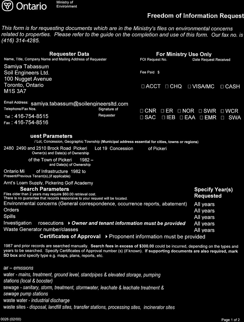

62


63


64
65 APPENDIX C ECOLOG ERIS REPORT REFERENCE NO E057

66 Project Property: Brock Rd, Pickering 2510 Brock Rd Pickering ON L1V2P8 Project No: 1703-E057 Report Type: Order No: Requested by: Quote - Custom-Build Your Own Report Soil Engineers Ltd. Date Completed: March 28, 2017
67 h-table of of Contents Table of Contents...2 Executive Summary...3 Executive Summary: Report Summary...4 Executive Summary: Site Report Summary - Project Property...6 Executive Summary: Site Report Summary - Surrounding Properties...7 Executive Summary: Summary By Data Source...9 Map...13 Aerial...14 Topographic Map...15 Detail Report...16 Unplottable Summary...55 Unplottable Report...57 Appendix: Database Descriptions...69 Definitions...77 Notice: IMPORTANT LIMITATIONS and YOUR LIABILITY Reliance on information in Report: This report DOES NOT replace a full Phase I Environmental Site Assessment but is solely intended to be used as a database review of environmental records. License for use of information in Report: No page of this report can be used without this cover page, this notice and the project property identifier. The information in Report(s) may not be modified or re-sold. Your Liability for misuse: Using this Service and/or its reports in a manner contrary to this Notice or your agreement will be in breach of copyright and contract and ERIS may obtain damages for such mis-use, including damages caused to third parties, and gives ERIS the right to terminate your account, rescind your license to any previous reports and to bar you from future use of the Service. No warranty of Accuracy or Liability for ERIS: The information contained in this report has been produced by ERIS Information Limited Partnership ("ERIS") using various sources of information, including information provided by Federal and Provincial government departments. The report applies only to the address and up to the date specified on the cover of this report, and any alterations or deviation from this description will require a new report. This report and the data contained herein does not purport to be and does not constitute a guarantee of the accuracy of the information contained herein and does not constitute a legal opinion nor medical advice. Although ERIS has endeavored to present you with information that is accurate, ERIS disclaims, any and all liability for any errors, omissions, or inaccuracies in such information and data, whether attributable to inadvertence, negligence or otherwise, and for any consequences arising therefrom. Liability on the part of ERIS is limited to the monetary value paid for this report. Trademark and Copyright: You may not use the ERIS trademarks or attribute any work to ERIS other than as outlined above. This Service and Report(s) are protected by copyright owned by ERIS Information Limited Partnership. Copyright in data used in the Service or Report(s) (the "Data") is owned by ERIS or its licensors. The Service, Report(s) and Data may not be copied or reproduced in whole or in any substantial part without prior written consent of ERIS. 2 erisinfo.com Environmental Risk Information Services Order No:
68 h-executive Summary Property Information: Project Property: Brock Rd, Pickering 2510 Brock Rd Pickering ON L1V2P8 Project No: 1703-E057 Order Information: Order No: Date Requested: March 22, 2017 Requested by: Soil Engineers Ltd. Report Type: Quote - Custom-Build Your Own Report Additional Products: 3 erisinfo.com Environmental Risk Information Services Order No:
69 h-executive Summary: Report Summary Database Name Searched Project Property Boundary to 0.25km Total rr-aagr-aa rr-agr-aa rr-amis-aa rr-andr-aa rr-auwr-aa rr-bore-aa rr-ca-aa rr-cfot-aa rr-chem-aa rr-cng-aa rr-coal-aa rr-conv-aa rr-cpu-aa rr-drl-aa rr-easr-aa rr-ebr-aa rr-eca-aa rr-eem-aa rr-ehs-aa rr-eiis-aa rr-emhe-aa rr-exp-aa rr-fcon-aa rr-fcs-aa rr-foft-aa rr-fst-aa rr-fsth-aa rr-gen-aa rr-ghg-aa rr-hinc-aa rr-iaft-aa rr-inc-aa rr-limo-aa rr-mine-aa rr-mnr-aa rr-nate-aa Abandoned Aggregate Inventory Y Aggregate Inventory Y Abandoned Mine Information System Y Anderson's Waste Disposal Sites Y Automobile Wrecking & Supplies Y Borehole Y Certificates of Approval Y Commercial Fuel Oil Tanks Y Chemical Register Y Compressed Natural Gas Stations Y Inventory of Coal Gasification Plants and Coal Tar Sites Y Compliance and Convictions Y Certificates of Property Use Y Drill Hole Database Y Environmental Activity and Sector Registry Y Environmental Registry Y Environmental Compliance Approval Y Environmental Effects Monitoring Y ERIS Historical Searches Y Environmental Issues Inventory System Y Emergency Management Historical Event Y List of TSSA Expired Facilities Y Federal Convictions Y Contaminated Sites on Federal Land Y Fisheries & Oceans Fuel Tanks Y Fuel Storage Tank Y Fuel Storage Tank - Historic Y Ontario Regulation 347 Waste Generators Summary Y Greenhouse Gas Emissions from Large Facilities Y TSSA Historic Incidents Y Indian & Northern Affairs Fuel Tanks Y TSSA Incidents Y Landfill Inventory Management Ontario Y Canadian Mine Locations Y Mineral Occurrences Y National Analysis of Trends in Emergencies System (NATES) Y erisinfo.com Environmental Risk Information Services Order No:
70 Database Name Searched Project Property Boundary to 0.25km Total rr-ncpl-aa rr-ndft-aa rr-ndsp-aa rr-ndwd-aa rr-nebw-aa rr-nees-aa rr-npcb-aa rr-npri-aa rr-ogw-aa rr-oogw-aa rr-opcb-aa rr-ord-aa rr-pap-aa rr-pcft-aa rr-pes-aa rr-pinc-aa rr-pipeline INCIDENTS-aa PIPELINE rr-prt-aa INCIDENTS PRT rr-pttw-aa rr-rec-aa rr-rsc-aa rr-rst-aa rr-sct-aa rr-spl-aa rr-srds-aa rr-tank-aa rr-tcft-aa rr-var-aa rr-wds-aa rr-wdsh-aa rr-wwis-aa Non-Compliance Reports Y National Defense & Canadian Forces Fuel Tanks Y National Defense & Canadian Forces Spills Y National Defence & Canadian Forces Waste Disposal Y Sites National Energy Board Wells Y National Environmental Emergencies System (NEES) Y National PCB Inventory Y National Pollutant Release Inventory Y Oil and Gas Wells Y Ontario Oil and Gas Wells Y Inventory of PCB Storage Sites Y Orders Y Canadian Pulp and Paper Y Parks Canada Fuel Storage Tanks Y Pesticide Register Y TSSA Pipeline Incidents Y National Energy Board Pipeline Incidents Y Private and Retail Fuel Storage Tanks Y Permit to Take Water Y Ontario Regulation 347 Waste Receivers Summary Y Record of Site Condition Y Retail Fuel Storage Tanks Y Scott's Manufacturing Directory Y Ontario Spills Y Wastewater Discharger Registration Database Y Anderson's Storage Tanks Y Transport Canada Fuel Storage Tanks Y TSSA Variances for Abandonment of Underground Y Storage Tanks Waste Disposal Sites - MOE CA Inventory Y Waste Disposal Sites - MOE 1991 Historical Approval Y Inventory Water Well Information System Y Total: erisinfo.com Environmental Risk Information Services Order No:
71 h-executive Summary: Site Site Report Summary - Project - Property Map Key DB Company/Site Name Address Dir/Dist (m) Elev diff (m) Page Number m1d 1 GEN dd-gen aa T. ARNTS LOAM SUPPLY LTD BROCK ROAD NORTH R.R. #1 PICKERING ON -/ p x m1d 1 GEN dd-gen aa T. ARNTS LOAM SUPPLY LTD BROCK ROAD NORTH R.R. #1 PICKERING ON L1V 2P8 -/ p x m1d 1 GEN dd-gen aa T. ARNTS LOAM SUPPLY LTD BROCK ROAD NORTH R.R. #1 PICKERING ON -/ p x m1d 1 GEN dd-gen aa T. ARNTS LOAM SUPPLY LTD BROCK ROAD NORTH R.R. #1 PICKERING ON L1V 2P8 -/ p x m1d 1 GEN dd-gen aa T. ARNTS LOAM SUPPLY LTD BROCK ROAD NORTH R.R. #1 PICKERING ON -/ p x m1d 1 GEN dd-gen aa T. ARNTS LOAM SUPPLY LTD BROCK ROAD NORTH PICKERING ON -/ p x m2d 2 dd-wwis aa lot 19 con 3 Pickering ON -/ p x m3d 3 dd-wwis aa lot 19 con 3 ON -/ p x 6 erisinfo.com Environmental Risk Information Services Order No:
72 h-executive Summary: Site Site Report Summary - Surrounding - Properties Map Key DB Company/Site Name Address Dir/Dist (m) Elev Diff (m) Page Number m4d 4 dd-wwis aa lot 19 con 3 ON SSE/ p x m5d 5 GEN dd-gen aa Chul-Joong Yoon 2460 Brock Road Pickering ON SE/ p x m5d 5 SPL dd-spl aa Private Residence<UNOFFICIAL> 2460 BROCK RD.<UNOFFICIAL> Pickering ON SE/ p x m6d 6 EHS dd-ehs aa 2540 Brock Road Pickering ON L1V 2P8 N/ p x m7d 7 EHS dd-ehs aa 2550 Brock Rd Pickering ON L1V2P8 NNW/ p x m8d 8 dd-wwis aa PICKERING ON N/ p x m9d 9 dd-wwis aa PICKERING ON SSE/ p x m10d dd-wwis aa lot 19 con 5 Pickering ON SSE/ p x m11d EHS dd-ehs aa 2460 Brock Rd Pickering ON L1V2P8 SSE/ p x m12d EHS dd-ehs aa Tillings Rd Dersan St Pickering ON SW/ p x m13d CA dd-ca aa Mount Pleasant Group of Cemeteries 2505 Brock Road North, R.R. #1 Pickering ON E/ p x m13d CA dd-ca aa Duffin Meadows Cemetery 2505 Brock Road North, R.R. #1 Pickering ON E/ p x m13d m13d m13d m13d m13d m13d m13d GEN dd-gen aa GEN dd-gen aa GEN dd-gen aa GEN dd-gen aa GEN dd-gen aa GEN dd-gen aa GEN dd-gen aa MOUNT PLEASANT GROUP OF CEMETERIES MOUNT PLEASANT GROUP OF CEMETERIES MOUNT PLEASANT GROUP OF CEMETERIES MOUNT PLEASANT GROUP OF CEMETERIES MOUNT PLEASANT GROUP OF CEMETERIES MOUNT PLEASANT GROUP OF CEMETERIES COMMEMORATIVE SERVICES OF ONTARIO DUFFIN MEADOWS CEMETERY & COMMEMOM. PARK 2505 BROCK ROAD NORTH PICKERING ON L1V 2P8 DUFFIN MEADOWS CEMETERY & COMMEMOM. PARK 2505 BROCK ROAD NORTH PICKERING ON L1V 2P8 DUFFIN MEADOWS CEMETERY & COMMEMOM. PARK 2505 BROCK ROAD NORTH PICKERING ON DUFFIN MEADOWS CEMETERY & COMMEMOM. PARK 2505 BROCK ROAD NORTH PICKERING ON DUFFIN MEADOWS CEMETERY & COMMEMOM. PARK 2505 BROCK ROAD NORTH PICKERING ON DUFFIN MEADOWS CEMETERY & COMMEMOM. PARK 2505 BROCK ROAD NORTH PICKERING ON L1V 2P8 DUFFIN MEADOWS CEMETERY & COMMEMORATIVE PARK, 2505 BROCK ROAD N. PICKERING ON L1V 2P8 E/ E/ E/ E/ E/ E/ E/ p x 33 p x 33 p x 33 p x 34 p x 34 p x 34 p x 7 erisinfo.com Environmental Risk Information Services Order No:
73 Map Key DB Company/Site Name Address Dir/Dist (m) Elev Diff (m) Page Number m13d m13d m13d m14d GEN dd-gen aa GEN dd-gen aa GEN dd-gen aa dd-wwis aa COMMEMORATIVE (SEE & USE ON ) MOUNT PLEASANT GROUP OF CEMETERIES MOUNT PLEASANT GROUP OF CEMETERIES DUFFIN MEADOWS CEMETERY & COMMEMORATIVE PARK BROCK ROAD NORTH PICKERING ON L1V 2P8 DUFFIN MEADOWS CEMETERY & COMMEMOM. PARK 2505 BROCK ROAD NORTH PICKERING ON L1V 2P8 DUFFIN MEADOWS CEMETERY & COMMEMOM. PARK 2505 BROCK ROAD NORTH PICKERING ON lot 19 con 3 ON E/ E/ E/ NNW/ p x 35 p x 35 p x 36 p x m15d dd-wwis aa lot 18 con 3 ON N/ p x m16d dd-wwis aa lot 19 con 3 ON NNW/ p x m17d EHS dd-ehs aa 1681 Dersan Street Pickering ON NW/ p x m18d EHS dd-ehs aa 2580 Brock Rd Pickering ON L1V2P8 N/ p x m18d EHS dd-ehs aa 2580 Brock Road Pickering ON L1V 2P8 N/ p x m18d EHS dd-ehs aa 2580 Brock Rd Pickering ON L1V2P8 N/ p x m18d GEN dd-gen aa VERNOY EXCAVATING LTD 2580 BROCK ROAD NORTH PICKERING ON L1V2P8 N/ p x m18d GEN dd-gen aa VERNOY EXCAVATING LTD 2580 BROCK ROAD NORTH PICKERING ON L1V2P8 N/ p x m18d m19d dd-spl aa dd-wwis aa STOUFFVILLE COOP ASSOCIATION 2580 BROCK RD., VERNOY EXCAVATING TANK TRUCK (CARGO) PICKERING TOWN ON lot 19 con 4 PICKERING ON N/ NW/ p x 42 p x m20d m21d RSC dd-rsc aa dd-wwis aa 2580 BROCK ROAD, PICKERING, ON L1V 2P8 Pickering ON lot 19 con 4 PICKERING ON NNW/ NNW/ p x 44 p x m22d dd-wwis aa ON S/ p x m23d dd-wwis aa ON WSW/ p x m24d dd-wwis aa lot 19 con 3 ON WNW/ p x m25d EHS dd-ehs aa 2585 Brock Rd Pickering ON L1V2P8 N/ p x m26d dd-wwis aa lot 19 con 3 ON NNW/ p x 8 erisinfo.com Environmental Risk Information Services Order No:
74 h-executive Summary: Summary By By Data Data Source Source CA - Certificates of Approval A search of the CA database, dated 1985-Oct 30, 2011* has found that there are 2 CA site(s) within approximately 0.25 kilometers of the project property. Site Address Distance (m) Map Key Duffin Meadows Cemetery 2505 Brock Road North, R.R. #1 Pickering ON m a Mount Pleasant Group of Cemeteries 2505 Brock Road North, R.R. #1 Pickering ON m a EHS - ERIS Historical Searches A search of the EHS database, dated 1999-Aug 2016 has found that there are 9 EHS site(s) within approximately 0.25 kilometers of the project property. Site Address Distance (m) Map Key 2540 Brock Road Pickering ON L1V 2P m a Brock Rd Pickering ON L1V2P Brock Rd Pickering ON L1V2P8 Tillings Rd Dersan St Pickering ON 1681 Dersan Street Pickering ON 2580 Brock Road Pickering ON L1V 2P Brock Rd Pickering ON L1V2P Brock Rd Pickering ON L1V2P Brock Rd Pickering ON L1V2P m a m a m a m a m a m a m a m a GEN - Ontario Regulation 347 Waste Generators Summary A search of the GEN database, dated 1986-Sep 2016 has found that there are 19 GEN site(s) within approximately 0.25 kilometers of the project property. 9 erisinfo.com Environmental Risk Information Services Order No:
75 Site Address Distance (m) Map Key T. ARNTS LOAM SUPPLY LTD BROCK ROAD NORTH PICKERING ON 0.0 m a 1 T. ARNTS LOAM SUPPLY LTD BROCK ROAD NORTH R.R. #1 PICKERING ON T. ARNTS LOAM SUPPLY LTD BROCK ROAD NORTH R.R. #1 PICKERING ON L1V 2P8 T. ARNTS LOAM SUPPLY LTD BROCK ROAD NORTH R.R. #1 PICKERING ON L1V 2P8 T. ARNTS LOAM SUPPLY LTD BROCK ROAD NORTH R.R. #1 PICKERING ON T. ARNTS LOAM SUPPLY LTD BROCK ROAD NORTH R.R. #1 PICKERING ON 0.0 m a m a m a m a m a 1 Chul-Joong Yoon MOUNT PLEASANT GROUP OF CEMETERIES MOUNT PLEASANT GROUP OF CEMETERIES COMMEMORATIVE (SEE & USE ON ) COMMEMORATIVE SERVICES OF ONTARIO MOUNT PLEASANT GROUP OF CEMETERIES MOUNT PLEASANT GROUP OF CEMETERIES MOUNT PLEASANT GROUP OF CEMETERIES MOUNT PLEASANT GROUP OF CEMETERIES MOUNT PLEASANT GROUP OF CEMETERIES MOUNT PLEASANT GROUP OF CEMETERIES VERNOY EXCAVATING LTD VERNOY EXCAVATING LTD 2460 Brock Road Pickering ON DUFFIN MEADOWS CEMETERY & COMMEMOM. PARK 2505 BROCK ROAD NORTH PICKERING ON DUFFIN MEADOWS CEMETERY & COMMEMOM. PARK 2505 BROCK ROAD NORTH PICKERING ON L1V 2P8 DUFFIN MEADOWS CEMETERY & COMMEMORATIVE PARK BROCK ROAD NORTH PICKERING ON L1V 2P8 DUFFIN MEADOWS CEMETERY & COMMEMORATIVE PARK, 2505 BROCK ROAD N. PICKERING ON L1V 2P8 DUFFIN MEADOWS CEMETERY & COMMEMOM. PARK 2505 BROCK ROAD NORTH PICKERING ON L1V 2P8 DUFFIN MEADOWS CEMETERY & COMMEMOM. PARK 2505 BROCK ROAD NORTH PICKERING ON DUFFIN MEADOWS CEMETERY & COMMEMOM. PARK 2505 BROCK ROAD NORTH PICKERING ON DUFFIN MEADOWS CEMETERY & COMMEMOM. PARK 2505 BROCK ROAD NORTH PICKERING ON DUFFIN MEADOWS CEMETERY & COMMEMOM. PARK 2505 BROCK ROAD NORTH PICKERING ON L1V 2P8 DUFFIN MEADOWS CEMETERY & COMMEMOM. PARK 2505 BROCK ROAD NORTH PICKERING ON L1V 2P BROCK ROAD NORTH PICKERING ON L1V2P BROCK ROAD NORTH PICKERING ON L1V2P m a m a m a m a m a m a m a m a m a m a m a m a m a 10 erisinfo.com Environmental Risk Information Services Order No:
76 RSC - Record of Site Condition A search of the RSC database, dated 1997-Sept 2001, Oct 2004-Dec 2016 has found that there are 1 RSC site(s) within approximately 0.25 kilometers of the project property. Site Address Distance (m) Map Key 2580 BROCK ROAD, PICKERING, ON L1V 2P8 Pickering ON m a SPL - Ontario Spills A search of the SPL database, dated 1988-Dec 2016 has found that there are 2 SPL site(s) within approximately 0.25 kilometers of the project property. Site Address Distance (m) Map Key Private Residence<UNOFFICIAL> 2460 BROCK RD.<UNOFFICIAL> Pickering ON 40.6 m a 5 STOUFFVILLE COOP ASSOCIATION 2580 BROCK RD., VERNOY EXCAVATING TANK TRUCK (CARGO) PICKERING TOWN ON m a WWIS - Water Well Information System A search of the WWIS database, dated Jun 30, 2016 has found that there are 15 WWIS site(s) within approximately 0.25 kilometers of the project property. Site Address Distance (m) Map Key lot 19 con 3 Pickering ON 0.0 m a 2 lot 19 con 3 ON lot 19 con 3 ON PICKERING ON PICKERING ON lot 19 con 5 Pickering ON lot 19 con 3 ON lot 18 con 3 ON lot 19 con 3 ON lot 19 con 4 PICKERING ON lot 19 con 4 PICKERING ON 0.0 m a m a m a m a m a m a m a m a m a m a 11 erisinfo.com Environmental Risk Information Services Order No:
77 Site Address Distance (m) Map Key m a ON ON lot 19 con 3 ON lot 19 con 3 ON m a m a m a 12 erisinfo.com Environmental Risk Information Services Order No:
 1 (6) #* BROCK RD 2 m2c #* m13c(12) 13 (12) #* 23 m23c #* 12 m12c #* 4 m4c #* 3 m3c #* m5c(2) 5 (2) #* 9 m9c #*#* 10 m10c 11 m11c #* 22 m22c #* m 130 65 0")
78 79 5'W LIATRIS DR 43 52'30"N 24 m24c #* #* 17 DERSAN ST m17c 19 m19c #* 16 m16c #* m21c #* m20c 20 #* 14 m14c #* 21 7 m7c #* 26 m26c #* m18c(6) 18 (6) #* m15c m8c #* m6c #* #* m25c #* WILLIAM JACKSON DR '30"N TILLINGS RD m1c(6) 1 (6) #* BROCK RD 2 m2c #* m13c(12) 13 (12) #* 23 m23c #* 12 m12c #* 4 m4c #* 3 m3c #* m5c(2) 5 (2) #* 9 m9c #*#* 10 m10c 11 m11c #* 22 m22c #* m Map : 0.25 Kilometer Radius Order No: Address: 2510 Brock Rd, Pickering, ON, L1V2P8 1:4600 CONCESSION RD 3 Project Property Buffer Outline #* Eris Sites with Higher Elevation ") Eris Sites with Same Elevation #* ( Eris Sites with Lower Elevation Eris Sites with Unknown Elevation Expressway Principal Highway Secondary Highway Major Road Local road Trail Industrial and Resource - Regions Main Line Sidetrack Transit Line Abandoned Line National Park Provincial or Territorial Park Other Park Golf Course or Driving Range Park or Sports Field Other Recreation Area Proposed Road Ferry Route/Ice Road Source: 2015 DMTI Spatial Inc. ERIS Information Limited Partnership


79 79 4'30"W 43 52'30"N 43 52'30"N Aerial m 1:10000 Source: Esri, DigitalGlobe, GeoEye, Earthstar Geographics, CNES/Airbus DS, USDA, USGS, AeroGRID, IGN, and the GIS User Community Order No: Address: 2510 Brock Rd, Pickering, ON, L1V2P8 Source: ESRI World Imagery ERIS Information Limited Partnership


,")

80 43 52'30"N 43 52'30"N Topographic Map Address: 2510 Brock Rd, Pickering, ON, L1V2P8 Source: ESRI World Topographic Map m Sources: Esri, HERE, DeLorme, Intermap, increment P Corp., GEBCO, USGS, FAO, NPS, NRCAN, GeoBase, IGN, Kadaster NL, Ordnance 1:10000Survey, Esri Japan, METI, Esri China (Hong Kong), swisstopo, MapmyIndia, OpenStreetMap contributors, and the GIS User Community Order No: ERIS Information Limited Partnership
81 h-detail Report Report Map Key Number of Records Direction/ Distance (m) Elevation (m) Site DB 1 m b 1 of 6 -/ T. ARNTS LOAM SUPPLY LTD BROCK ROAD NORTH R.R. #1 PICKERING ON dd-gen bb p y GEN PO Box Num: Status: Country: Generator #: ON Approval Yrs:: 2011 SIC Code: SIC Description: Landscaping Services --Details-- Waste Code: 251 Waste Description: OIL SKIMMINGS & SLUDGES Waste Code: 212 Waste Description: ALIPHATIC SOLVENTS Waste Code: 252 Waste Description: WASTE OILS & LUBRICANTS 1 m b 2 of 6 -/ T. ARNTS LOAM SUPPLY LTD BROCK ROAD NORTH R.R. #1 PICKERING ON L1V 2P8 dd-gen bb p y GEN PO Box Num: Status: Country: Generator #: ON Approval Yrs:: 02,03,04,05,06,07,08 SIC Code: SIC Description: --Details-- Waste Code: 212 Waste Description: ALIPHATIC SOLVENTS Waste Code: 252 Waste Description: WASTE OILS & LUBRICANTS 1 m b 3 of 6 -/ T. ARNTS LOAM SUPPLY LTD BROCK ROAD NORTH R.R. #1 PICKERING ON dd-gen bb p y GEN PO Box Num: Status: Country: Generator #: ON Approval Yrs:: 2010 SIC Code: erisinfo.com Environmental Risk Information Services Order No:
82 Map Key Number of Records Direction/ Distance (m) Elevation (m) Site DB SIC Description: Landscaping Services --Details-- Waste Code: 251 Waste Description: OIL SKIMMINGS & SLUDGES Waste Code: 212 Waste Description: ALIPHATIC SOLVENTS Waste Code: 252 Waste Description: WASTE OILS & LUBRICANTS 1 m b 4 of 6 -/ T. ARNTS LOAM SUPPLY LTD BROCK ROAD NORTH R.R. #1 PICKERING ON L1V 2P8 dd-gen bb p y GEN PO Box Num: Status: Country: Generator #: ON Approval Yrs:: 2012 SIC Code: SIC Description: Landscaping Services --Details-- Waste Code: 251 Waste Description: OIL SKIMMINGS & SLUDGES Waste Code: 212 Waste Description: ALIPHATIC SOLVENTS Waste Code: 252 Waste Description: WASTE OILS & LUBRICANTS 1 m b 5 of 6 -/ T. ARNTS LOAM SUPPLY LTD BROCK ROAD NORTH R.R. #1 PICKERING ON dd-gen bb p y GEN PO Box Num: Status: Country: Generator #: ON Approval Yrs:: 2009 SIC Code: SIC Description: Landscaping Services --Details-- Waste Code: 212 Waste Description: ALIPHATIC SOLVENTS Waste Code: 251 Waste Description: OIL SKIMMINGS & SLUDGES Waste Code: 252 Waste Description: WASTE OILS & LUBRICANTS 1 m b 6 of 6 -/ T. ARNTS LOAM SUPPLY LTD. dd-gen bb p y GEN 17 erisinfo.com Environmental Risk Information Services Order No:
83 Map Key Number of Records Direction/ Distance (m) Elevation (m) Site DB 2490 BROCK ROAD NORTH PICKERING ON PO Box Num: Status: Country: Generator #: ON Approval Yrs:: 95,96,97,98,99,00,01 SIC Code: 6599 SIC Description: OTHER RETAIL STORES --Details-- Waste Code: 212 Waste Description: ALIPHATIC SOLVENTS Waste Code: 252 Waste Description: WASTE OILS & LUBRICANTS 2 m b 1 of 1 -/ lot 19 con 3 Pickering ON dd-wwis bb p y WWIS Well ID: Lot: 019 Construction Date:: Concession: 03 Primary Water Use:: Domestic Concession Name: Sec. Water Use:: Easting NAD83:: Final Well Status:: Abandoned-Other Northing NAD83:: Specific Capacity:: Zone:: Municipality: PICKERING TOWN UTM Reliability:: County: DURHAM Bore Hole Information Bore Hole ID: DP2BR: Code OB: Code OB Description: Open Hole: Date Completed: 15-JAN-10 Remarks: Zone: East 83: North 83: UTMRC: 9 UTMRC Description: unknown UTM Location Method: wwr Org CS: UTM83 Elevation: Elevrc: Elevrc Description: Location Source Date: Source Revision Comment: Improvement Location Source: Improvement Location Method: Supplier Comment: Spatial Status: Overburden and Bedrock Materials Interval Formation ID: Layer: 1 General Color: Most Common Material: 18 erisinfo.com Environmental Risk Information Services Order No:
84 Map Key Number of Records Direction/ Distance (m) Elevation (m) Site DB Other Materials: Other Materials: Formation Top Depth: 0 Formation End Depth: Formation End Depth UOM: ft Method of Construction & Well Use Method Construction ID: Method Construction Code: Method Construction: Other Method Construction: Pipe Information Pipe ID: Casing Number: 0 Comment: Alt Name: Construction Record - Casing Casing ID: Layer: 1 Open Hole or Material: STEEL Depth From: 0 Depth To: Casing Diameter: 6 Casing Diameter UOM: inch Casing Depth UOM: ft Construction Record - Screen Screen ID: Layer: Slot: Screen Top Depth: Screen End Depth: Screen Material: Screen Depth UOM: ft Screen Diameter UOM: inch Screen Diameter: Hole Diameter Hole ID: Diameter: 6 Depth From: 0 Depth To: Hole Depth UOM: ft Hole Diameter UOM: inch 3 m b 1 of 1 -/ lot 19 con 3 ON dd-wwis bb p y WWIS Well ID: Lot: 019 Construction Date:: Concession: 03 Primary Water Use:: Domestic Concession Name: CON Sec. Water Use:: Easting NAD83:: Final Well Status:: Water Supply Northing NAD83:: Specific Capacity:: Zone:: 19 erisinfo.com Environmental Risk Information Services Order No:
85 Map Key Number of Records Direction/ Distance (m) Elevation (m) Site DB Municipality: PICKERING TOWN UTM Reliability:: County: DURHAM Bore Hole Information Bore Hole ID: DP2BR: Code OB: o Code OB Description: Overburden Open Hole: Date Completed: 23-OCT-64 Remarks: Zone: 17 East 83: North 83: UTMRC: 5 UTMRC Description: margin of error : 100 m m Location Method: p5 Org CS: Elevation: Elevrc: Elevrc Description: Location Source Date: Source Revision Comment: Improvement Location Source: Improvement Location Method: Supplier Comment: Spatial Status: Overburden and Bedrock Materials Interval Formation ID: Layer: 1 General Color: Most Common Material: TOPSOIL Other Materials: Other Materials: Formation Top Depth: 0 Formation End Depth: 1 Formation End Depth UOM: ft Formation ID: Layer: 2 General Color: BROWN Most Common Material: CLAY Other Materials: STONES Other Materials: Formation Top Depth: 1 Formation End Depth: 9 Formation End Depth UOM: ft Formation ID: Layer: 3 General Color: BLUE Most Common Material: CLAY Other Materials: STONES Other Materials: Formation Top Depth: 9 Formation End Depth: 22 Formation End Depth UOM: ft Formation ID: Layer: 4 General Color: Most Common Material: FINE SAND 20 erisinfo.com Environmental Risk Information Services Order No:
86 Map Key Number of Records Direction/ Distance (m) Elevation (m) Site DB Other Materials: Other Materials: Formation Top Depth: 22 Formation End Depth: 27 Formation End Depth UOM: ft Formation ID: Layer: 5 General Color: Most Common Material: GRAVEL Other Materials: Other Materials: Formation Top Depth: 27 Formation End Depth: 28 Formation End Depth UOM: ft Formation ID: Layer: 6 General Color: BLUE Most Common Material: CLAY Other Materials: MEDIUM SAND Other Materials: Formation Top Depth: 28 Formation End Depth: 32 Formation End Depth UOM: ft Method of Construction & Well Use Method Construction ID: Method Construction Code: 6 Method Construction: Boring Other Method Construction: Pipe Information Pipe ID: Casing Number: 1 Comment: Alt Name: Construction Record - Casing Casing ID: Layer: 1 Open Hole or Material: CONCRETE Depth From: Depth To: 32 Casing Diameter: 30 Casing Diameter UOM: inch Casing Depth UOM: ft Well Yield Testing Pump Test ID: Pump Set At: Static Level: 8 Final Level After Pumping: Recommended Pump Depth: 30 Pumping Rate: 1 Flowing Rate: Recommended Pump Rate: 0 Levels UOM: ft Rate UOM: GPM Water State After Test Code: 1 Water State After Test: CLEAR 21 erisinfo.com Environmental Risk Information Services Order No:
87 Map Key Number of Records Direction/ Distance (m) Elevation (m) Site DB Pumping Test Method: 1 Pumping Duration HR: Pumping Duration MIN: Flowing: N Water Details Water ID: Layer: 1 Kind Code: 1 Kind: FRESH Water Found Depth: 22 Water Found Depth UOM: ft 4 m b 1 of 1 SSE/ lot 19 con 3 ON dd-wwis bb p y WWIS Well ID: Lot: 019 Construction Date:: Concession: 03 Primary Water Use:: Domestic Concession Name: CON Sec. Water Use:: Easting NAD83:: Final Well Status:: Water Supply Northing NAD83:: Specific Capacity:: Zone:: Municipality: PICKERING TOWN UTM Reliability:: County: DURHAM Bore Hole Information Bore Hole ID: DP2BR: Code OB: _ Code OB Description: No formation data Open Hole: Date Completed: 20-NOV-95 Remarks: Zone: 17 East 83: North 83: UTMRC: 4 UTMRC Description: margin of error : 30 m m Location Method: gps Org CS: Elevation: Elevrc: Elevrc Description: Location Source Date: Source Revision Comment: Improvement Location Source: Improvement Location Method: Supplier Comment: Spatial Status: Method of Construction & Well Use Method Construction ID: Method Construction Code: 1 Method Construction: Cable Tool Other Method Construction: Pipe Information Pipe ID: erisinfo.com Environmental Risk Information Services Order No:
88 Map Key Number of Records Direction/ Distance (m) Elevation (m) Site DB Casing Number: 1 Comment: Alt Name: Construction Record - Casing Casing ID: Layer: 1 Open Hole or Material: CONCRETE Depth From: Depth To: 33 Casing Diameter: 36 Casing Diameter UOM: inch Casing Depth UOM: ft Well Yield Testing Pump Test ID: Pump Set At: Static Level: 20 Final Level After Pumping: 32 Recommended Pump Depth: 31 Pumping Rate: 25 Flowing Rate: Recommended Pump Rate: 4 Levels UOM: ft Rate UOM: GPM Water State After Test Code: 1 Water State After Test: CLEAR Pumping Test Method: 1 Pumping Duration HR: 1 Pumping Duration MIN: 30 Flowing: N Draw Down & Recovery Pump Test Detail ID: Pump Test ID: Test Type: Test Duration: 15 Test Level: 31 Test Level UOM: ft Pump Test Detail ID: Pump Test ID: Test Type: Test Duration: 30 Test Level: 29 Test Level UOM: ft Pump Test Detail ID: Pump Test ID: Test Type: Test Duration: 45 Test Level: 27 Test Level UOM: ft Pump Test Detail ID: Pump Test ID: Test Type: Test Duration: 60 Test Level: 26 Test Level UOM: ft Water Details 23 erisinfo.com Environmental Risk Information Services Order No:
89 Map Key Number of Records Direction/ Distance (m) Elevation (m) Site DB Water ID: Layer: 1 Kind Code: 1 Kind: FRESH Water Found Depth: Water Found Depth UOM: ft 5 m b 1 of 2 SE/ Chul-Joong Yoon 2460 Brock Road Pickering ON dd-gen bb p y GEN PO Box Num: Status: Country: Generator #: ON Approval Yrs:: 03,04 SIC Code: SIC Description: 5 m b 2 of 2 SE/ Private Residence<UNOFFICIAL> 2460 BROCK RD.<UNOFFICIAL> Pickering ON dd-spl bb p y SPL Ref No: RBJG4 Contaminant Code: 13 Contaminant Name: FURNACE OIL Contaminant Quantity: Incident Cause: Tank (Above Ground) Leak Incident Dt: 9/12/2003 Incident Reason: Incident Summary: Furnace oil spill. MOE Reported Dt: 9/12/2003 Environmental Impact: Nature of Impact: Soil Contamination Receiving Medium: Land SAC Action Class: Spills Sector Source Type: Other Storage Facility Receiving Environment: Incident Event: Site Municipality: Pickering 6 m b 1 of 1 N/ Brock Road Pickering ON L1V 2P8 dd-ehs bb p y EHS Postal Code: City: Address2: Address1: Provstate: Order No.: Addit. Info Ordered:: Report Date: 2/11/2011 Report Type: Standard Report Search Radius (km): m b 1 of 1 NNW/ Brock Rd Pickering ON L1V2P8 dd-ehs bb p y EHS 24 erisinfo.com Environmental Risk Information Services Order No:
90 Map Key Number of Records Direction/ Distance (m) Elevation (m) Site DB Postal Code: L1V2P8 City: Pickering Address2: Address1: 2550 Brock Rd Provstate: ON Order No.: Addit. Info Ordered:: Topographic Maps Report Date: 24-JUN-16 Report Type: Standard Report Search Radius (km):.25 8 m b 1 of 1 N/ PICKERING ON dd-wwis bb p y WWIS Well ID: Lot: Construction Date:: Concession: Primary Water Use:: Monitoring Concession Name: Sec. Water Use:: Easting NAD83:: Final Well Status:: Observation Wells Northing NAD83:: Specific Capacity:: Zone:: Municipality: PICKERING TOWN UTM Reliability:: County: DURHAM Bore Hole Information Bore Hole ID: DP2BR: Code OB: Code OB Description: Open Hole: Date Completed: 17-DEC-13 Remarks: Zone: 17 East 83: North 83: UTMRC: 4 UTMRC Description: margin of error : 30 m m Location Method: wwr Org CS: UTM83 Elevation: Elevrc: Elevrc Description: Location Source Date: Source Revision Comment: Improvement Location Source: Improvement Location Method: Supplier Comment: Spatial Status: Overburden and Bedrock Materials Interval Formation ID: Layer: 1 General Color: BROWN Most Common Material: FILL Other Materials: Other Materials: LOOSE Formation Top Depth: 0 Formation End Depth: 1.5 Formation End Depth UOM: m Formation ID: erisinfo.com Environmental Risk Information Services Order No:
91 Map Key Number of Records Direction/ Distance (m) Elevation (m) Site DB Layer: 2 General Color: BROWN Most Common Material: SILT Other Materials: GRAVEL Other Materials: DENSE Formation Top Depth: 1.5 Formation End Depth: 4.6 Formation End Depth UOM: m Formation ID: Layer: 3 General Color: GREY Most Common Material: GRAVEL Other Materials: Other Materials: DENSE Formation Top Depth: 4.6 Formation End Depth: 9.2 Formation End Depth UOM: m Annular Space/Abandonment Sealing Record Plug ID: Layer: 1 Plug From: 0 Plug To: 5.9 Plug Depth UOM: m Plug ID: Layer: 2 Plug From: 5.9 Plug To: 9.2 Plug Depth UOM: m Method of Construction & Well Use Method Construction ID: Method Construction Code: 6 Method Construction: Boring Other Method Construction: Pipe Information Pipe ID: Casing Number: 0 Comment: Alt Name: Construction Record - Casing Casing ID: Layer: 1 Open Hole or Material: PLASTIC Depth From: 0 Depth To: 6.2 Casing Diameter: 5.2 Casing Diameter UOM: cm Casing Depth UOM: m Construction Record - Screen Screen ID: Layer: 1 Slot: erisinfo.com Environmental Risk Information Services Order No:
92 Map Key Number of Records Direction/ Distance (m) Elevation (m) Site DB Screen Top Depth: 6.2 Screen End Depth: 9.2 Screen Material: 5 Screen Depth UOM: m Screen Diameter UOM: cm Screen Diameter: 6.4 Hole Diameter Hole ID: Diameter: 21 Depth From: 0 Depth To: 9.2 Hole Depth UOM: m Hole Diameter UOM: cm 9 m b 1 of 1 SSE/ PICKERING ON dd-wwis bb p y WWIS Well ID: Lot: Construction Date:: Concession: Primary Water Use:: Concession Name: Sec. Water Use:: Easting NAD83:: Final Well Status:: Observation Wells Northing NAD83:: Specific Capacity:: Zone:: Municipality: PICKERING TOWN UTM Reliability:: County: DURHAM Bore Hole Information Bore Hole ID: DP2BR: Code OB: o Code OB Description: Overburden Open Hole: Date Completed: 06-JUN-06 Remarks: Zone: 17 East 83: North 83: UTMRC: 3 UTMRC Description: margin of error : m Location Method: wwr Org CS: UTM83 Elevation: Elevrc: Elevrc Description: Location Source Date: Source Revision Comment: Improvement Location Source: Improvement Location Method: Supplier Comment: Spatial Status: Overburden and Bedrock Materials Interval Formation ID: Layer: 1 General Color: Most Common Material: TOPSOIL Other Materials: Other Materials: 27 erisinfo.com Environmental Risk Information Services Order No:
93 Map Key Number of Records Direction/ Distance (m) Elevation (m) Site DB Formation Top Depth: 0 Formation End Depth:.6 Formation End Depth UOM: m Formation ID: Layer: 2 General Color: BROWN Most Common Material: SAND Other Materials: GRAVEL Other Materials: Formation Top Depth:.6 Formation End Depth: 1.5 Formation End Depth UOM: m Formation ID: Layer: 3 General Color: BROWN Most Common Material: SILT Other Materials: SAND Other Materials: CLAY Formation Top Depth: 1.5 Formation End Depth: 12.3 Formation End Depth UOM: m Formation ID: Layer: 4 General Color: GREY Most Common Material: SAND Other Materials: GRAVEL Other Materials: LOOSE Formation Top Depth: 12.3 Formation End Depth: 21 Formation End Depth UOM: m Formation ID: Layer: 5 General Color: GREY Most Common Material: SILT Other Materials: SAND Other Materials: CLAY Formation Top Depth: 21 Formation End Depth: 21.3 Formation End Depth UOM: m Annular Space/Abandonment Sealing Record Plug ID: Layer: 1 Plug From: 0 Plug To:.2 Plug Depth UOM: m Plug ID: Layer: 2 Plug From:.2 Plug To: 17.4 Plug Depth UOM: m Plug ID: Layer: 3 Plug From: 17.4 Plug To: 21.3 Plug Depth UOM: m Method of Construction & Well 28 erisinfo.com Environmental Risk Information Services Order No:
94 Map Key Number of Records Direction/ Distance (m) Elevation (m) Site DB Use Method Construction ID: Method Construction Code: B Method Construction: Other Method Other Method Construction: Pipe Information Pipe ID: Casing Number: 1 Comment: Alt Name: Construction Record - Casing Casing ID: Layer: 1 Open Hole or Material: PLASTIC Depth From: 0 Depth To: 18 Casing Diameter: 5.1 Casing Diameter UOM: cm Casing Depth UOM: m Construction Record - Screen Screen ID: Layer: 1 Slot: 10 Screen Top Depth: 18 Screen End Depth: 21 Screen Material: 5 Screen Depth UOM: m Screen Diameter UOM: cm Screen Diameter: 6 Hole Diameter Hole ID: Diameter: 13 Depth From: 0 Depth To: 21.3 Hole Depth UOM: m Hole Diameter UOM: cm 10 m b 1 of 1 SSE/ lot 19 con 5 Pickering ON dd-wwis bb p y WWIS Well ID: Lot: 019 Construction Date:: Concession: 05 Primary Water Use:: Concession Name: CON Sec. Water Use:: Easting NAD83:: Final Well Status:: Abandoned-Other Northing NAD83:: Specific Capacity:: Zone:: Municipality: PICKERING TOWN UTM Reliability:: County: DURHAM Bore Hole Information Bore Hole ID: DP2BR: 29 erisinfo.com Environmental Risk Information Services Order No:
95 Map Key Number of Records Direction/ Distance (m) Elevation (m) Site DB Code OB: Code OB Description: Open Hole: Date Completed: 15-APR-14 Remarks: Zone: 17 East 83: North 83: UTMRC: 4 UTMRC Description: margin of error : 30 m m Location Method: wwr Org CS: UTM83 Elevation: Elevrc: Elevrc Description: Location Source Date: Source Revision Comment: Improvement Location Source: Improvement Location Method: Supplier Comment: Spatial Status: Overburden and Bedrock Materials Interval Formation ID: Layer: General Color: Most Common Material: Other Materials: Other Materials: Formation Top Depth: Formation End Depth: Formation End Depth UOM: ft Annular Space/Abandonment Sealing Record Plug ID: Layer: 1 Plug From: 0 Plug To: Plug Depth UOM: ft Plug ID: Layer: 2 Plug From: 53 Plug To: 0 Plug Depth UOM: ft Plug ID: Layer: 3 Plug From: 56 Plug To: 53 Plug Depth UOM: ft Plug ID: Layer: 4 Plug From: 66 Plug To: 56 Plug Depth UOM: ft Plug ID: Layer: 5 Plug From: 66 Plug To: 30 erisinfo.com Environmental Risk Information Services Order No:
96 Map Key Number of Records Direction/ Distance (m) Elevation (m) Site DB Plug Depth UOM: ft Method of Construction & Well Use Method Construction ID: Method Construction Code: Method Construction: Other Method Construction: Pipe Information Pipe ID: Casing Number: 0 Comment: Alt Name: Construction Record - Casing Casing ID: Layer: 1 Open Hole or Material: PLASTIC Depth From: 0 Depth To: 56 Casing Diameter: 2 Casing Diameter UOM: inch Casing Depth UOM: ft Construction Record - Screen Screen ID: Layer: 1 Slot: Screen Top Depth: 56 Screen End Depth: 66 Screen Material: 5 Screen Depth UOM: ft Screen Diameter UOM: inch Screen Diameter: 2 Hole Diameter Hole ID: Diameter: 2 Depth From: 0 Depth To: 60 Hole Depth UOM: ft Hole Diameter UOM: inch 11 m b 1 of 1 SSE/ Brock Rd Pickering ON L1V2P8 dd-ehs bb p y EHS Postal Code: L1V2P8 City: Pickering Address2: Address1: 2460 Brock Rd Provstate: ON Order No.: Addit. Info Ordered:: Report Date: 23-DEC-14 Report Type: Custom Report Search Radius (km): erisinfo.com Environmental Risk Information Services Order No:
97 Map Key Number of Records Direction/ Distance (m) Elevation (m) Site DB 12 m b 1 of 1 SW/ Tillings Rd Dersan St Pickering ON dd-ehs bb p y EHS Postal Code: City: Pickering Address2: Address1: Tillings Rd Dersan St Provstate: ON Order No.: Addit. Info Ordered:: Aerial Photos Report Date: 22-OCT-14 Report Type: RSC Report - Quote Search Radius (km):.3 13 m b 1 of 12 E/ Mount Pleasant Group of Cemeteries 2505 Brock Road North, R.R. #1 Pickering ON dd-ca bb p y CA Certificate #: KBJVQ Application Year: 2003 Issue Date: 3/17/2003 Approval Type: Municipal and Private Sewage Works Status: Approved Application Type: Client Name:: Client Address:: Client City:: Client Postal Code:: Project Description:: Contaminants:: Emission Control:: 13 m b 2 of 12 E/ Duffin Meadows Cemetery 2505 Brock Road North, R.R. #1 Pickering ON dd-ca bb p y CA Certificate #: Application Year: 01 Issue Date: 8/28/01 Approval Type: Municipal & Private sewage Status: Cancelled Application Type: New Certificate of Approval Client Name:: Mount Pleasant Group of Cemeteries Client Address:: Overlea Boulevard Client City:: Toronto Client Postal Code:: Project Description:: Contaminants:: Emission Control:: M4H 1P1 This application is for installation of storm sewer piping to service a proposed cemetery expansion including the construction of two (2) storm water management ponds. 13 m b 3 of 12 E/ MOUNT PLEASANT GROUP OF CEMETERIES DUFFIN MEADOWS CEMETERY & COMMEMOM. PARK 2505 BROCK ROAD NORTH PICKERING ON L1V 2P8 dd-gen bb p y GEN PO Box Num: Status: 32 erisinfo.com Environmental Risk Information Services Order No:
98 Map Key Number of Records Direction/ Distance (m) Elevation (m) Site DB Country: Generator #: ON Approval Yrs:: 99,00,01,02,03,04,05,06,07,08 SIC Code: 9732 SIC Description: CEMETERIES/CREMATOR. --Details-- Waste Code: 252 Waste Description: WASTE OILS & LUBRICANTS 13 m b 4 of 12 E/ MOUNT PLEASANT GROUP OF CEMETERIES DUFFIN MEADOWS CEMETERY & COMMEMOM. PARK 2505 BROCK ROAD NORTH PICKERING ON L1V 2P8 dd-gen bb p y GEN PO Box Num: Status: Registered Country: Canada Generator #: ON Approval Yrs:: As of Sep 2016 SIC Code: SIC Description: --Details-- Waste Code: Waste Description: Waste Code: Waste Description: Waste Code: Waste Description: 251 I Waste oils/sludges (petroleum based) 252 L Waste crankcase oils and lubricants 252 I Waste crankcase oils and lubricants 13 m b 5 of 12 E/ MOUNT PLEASANT GROUP OF CEMETERIES DUFFIN MEADOWS CEMETERY & COMMEMOM. PARK 2505 BROCK ROAD NORTH PICKERING ON dd-gen bb p y GEN PO Box Num: Status: Country: Generator #: ON Approval Yrs:: 2011 SIC Code: SIC Description: Cemeteries and Crematoria --Details-- Waste Code: 252 Waste Description: WASTE OILS & LUBRICANTS 13 m b 6 of 12 E/ MOUNT PLEASANT GROUP OF CEMETERIES DUFFIN MEADOWS CEMETERY & COMMEMOM. PARK 2505 BROCK ROAD NORTH PICKERING ON dd-gen bb p y GEN PO Box Num: Status: Country: 33 erisinfo.com Environmental Risk Information Services Order No:
99 Map Key Number of Records Direction/ Distance (m) Elevation (m) Site DB Generator #: ON Approval Yrs:: 2010 SIC Code: SIC Description: Cemeteries and Crematoria --Details-- Waste Code: 252 Waste Description: WASTE OILS & LUBRICANTS 13 m b 7 of 12 E/ MOUNT PLEASANT GROUP OF CEMETERIES DUFFIN MEADOWS CEMETERY & COMMEMOM. PARK 2505 BROCK ROAD NORTH PICKERING ON dd-gen bb p y GEN PO Box Num: Status: Country: Generator #: ON Approval Yrs:: 2009 SIC Code: SIC Description: Cemeteries and Crematoria --Details-- Waste Code: 252 Waste Description: WASTE OILS & LUBRICANTS 13 m b 8 of 12 E/ MOUNT PLEASANT GROUP OF CEMETERIES DUFFIN MEADOWS CEMETERY & COMMEMOM. PARK 2505 BROCK ROAD NORTH PICKERING ON L1V 2P8 dd-gen bb p y GEN PO Box Num: Status: Country: Generator #: ON Approval Yrs:: 2012 SIC Code: SIC Description: Cemeteries and Crematoria --Details-- Waste Code: 252 Waste Description: WASTE OILS & LUBRICANTS 13 m b 9 of 12 E/ COMMEMORATIVE SERVICES OF ONTARIO DUFFIN MEADOWS CEMETERY & COMMEMORATIVE PARK, 2505 BROCK ROAD N. PICKERING ON L1V 2P8 dd-gen bb p y GEN PO Box Num: Status: Country: Generator #: ON Approval Yrs:: 93,94,95,96,97,98 SIC Code: 9999 SIC Description: OTHER SERVICES 34 erisinfo.com Environmental Risk Information Services Order No:
100 Map Key Number of Records Direction/ Distance (m) Elevation (m) Site DB --Details-- Waste Code: 252 Waste Description: WASTE OILS & LUBRICANTS 13 m b 10 of 12 E/ COMMEMORATIVE (SEE & USE ON ) DUFFIN MEADOWS CEMETERY & COMMEMORATIVE PARK BROCK ROAD NORTH PICKERING ON L1V 2P8 dd-gen bb p y GEN PO Box Num: Status: Country: Generator #: ON Approval Yrs:: 99 SIC Code: 9999 SIC Description: OTHER SERVICES --Details-- Waste Code: 252 Waste Description: WASTE OILS & LUBRICANTS 13 m b 11 of 12 E/ MOUNT PLEASANT GROUP OF CEMETERIES DUFFIN MEADOWS CEMETERY & COMMEMOM. PARK 2505 BROCK ROAD NORTH PICKERING ON L1V 2P8 dd-gen bb p y GEN PO Box Num: Status: Country: Generator #: ON Approval Yrs:: As of May 2015 SIC Code: SIC Description: --Details-- Waste Code: 252 Waste Description: Waste crankcase oils and lubricants 13 m b 12 of 12 E/ MOUNT PLEASANT GROUP OF CEMETERIES DUFFIN MEADOWS CEMETERY & COMMEMOM. PARK 2505 BROCK ROAD NORTH PICKERING ON dd-gen bb p y GEN PO Box Num: Status: Country: Generator #: ON Approval Yrs:: 2013 SIC Code: SIC Description: --Details-- Waste Code: 252 Waste Description: WASTE OILS & LUBRICANTS 35 erisinfo.com Environmental Risk Information Services Order No:
101 Map Key Number of Records Direction/ Distance (m) Elevation (m) Site DB 14 m b 1 of 1 NNW/ lot 19 con 3 ON dd-wwis bb p y WWIS Well ID: Lot: 019 Construction Date:: Concession: 03 Primary Water Use:: Domestic Concession Name: CON Sec. Water Use:: Easting NAD83:: Final Well Status:: Water Supply Northing NAD83:: Specific Capacity:: Zone:: Municipality: PICKERING TOWN UTM Reliability:: County: DURHAM Bore Hole Information Bore Hole ID: DP2BR: Code OB: o Code OB Description: Overburden Open Hole: Date Completed: 08-SEP-95 Remarks: Zone: 17 East 83: North 83: UTMRC: 4 UTMRC Description: margin of error : 30 m m Location Method: gps Org CS: Elevation: Elevrc: Elevrc Description: Location Source Date: Source Revision Comment: Improvement Location Source: Improvement Location Method: Supplier Comment: Spatial Status: Overburden and Bedrock Materials Interval Formation ID: Layer: 1 General Color: BROWN Most Common Material: SAND Other Materials: Other Materials: Formation Top Depth: 0 Formation End Depth: 28 Formation End Depth UOM: ft Method of Construction & Well Use Method Construction ID: Method Construction Code: 1 Method Construction: Cable Tool Other Method Construction: Pipe Information Pipe ID: Casing Number: 1 Comment: Alt Name: 36 erisinfo.com Environmental Risk Information Services Order No:
102 Map Key Number of Records Direction/ Distance (m) Elevation (m) Site DB Construction Record - Casing Casing ID: Layer: 1 Open Hole or Material: CONCRETE Depth From: Depth To: 28 Casing Diameter: 30 Casing Diameter UOM: inch Casing Depth UOM: ft Well Yield Testing Pump Test ID: Pump Set At: Static Level: 0 Final Level After Pumping: 27 Recommended Pump Depth: 25 Pumping Rate: Flowing Rate: Recommended Pump Rate: 9 Levels UOM: ft Rate UOM: GPM Water State After Test Code: 1 Water State After Test: CLEAR Pumping Test Method: Pumping Duration HR: Pumping Duration MIN: Flowing: N Draw Down & Recovery Pump Test Detail ID: Pump Test ID: Test Type: Test Duration: 15 Test Level: 24 Test Level UOM: ft Pump Test Detail ID: Pump Test ID: Test Type: Test Duration: 30 Test Level: 22 Test Level UOM: ft Pump Test Detail ID: Pump Test ID: Test Type: Test Duration: 45 Test Level: 21 Test Level UOM: ft Pump Test Detail ID: Pump Test ID: Test Type: Test Duration: 60 Test Level: 20 Test Level UOM: ft Water Details Water ID: Layer: 1 Kind Code: 1 37 erisinfo.com Environmental Risk Information Services Order No:
103 Map Key Number of Records Direction/ Distance (m) Elevation (m) Site DB Kind: FRESH Water Found Depth: 27 Water Found Depth UOM: ft 15 m b 1 of 1 N/ lot 18 con 3 ON dd-wwis bb p y WWIS Well ID: Lot: 018 Construction Date:: Concession: 03 Primary Water Use:: Domestic Concession Name: CON Sec. Water Use:: Easting NAD83:: Final Well Status:: Water Supply Northing NAD83:: Specific Capacity:: Zone:: Municipality: PICKERING TOWN UTM Reliability:: County: DURHAM Bore Hole Information Bore Hole ID: DP2BR: Code OB: _ Code OB Description: No formation data Open Hole: Date Completed: 22-JUL-98 Remarks: Zone: 17 East 83: North 83: UTMRC: 4 UTMRC Description: margin of error : 30 m m Location Method: gps Org CS: Elevation: Elevrc: Elevrc Description: Location Source Date: Source Revision Comment: Improvement Location Source: Improvement Location Method: Supplier Comment: Spatial Status: Method of Construction & Well Use Method Construction ID: Method Construction Code: 1 Method Construction: Cable Tool Other Method Construction: Pipe Information Pipe ID: Casing Number: 1 Comment: Alt Name: 16 m b 1 of 1 NNW/ lot 19 con 3 ON dd-wwis bb p y WWIS Well ID: Lot: erisinfo.com Environmental Risk Information Services Order No:
104 Map Key Number of Records Direction/ Distance (m) Elevation (m) Site DB Construction Date:: Concession: 03 Primary Water Use:: Domestic Concession Name: CON Sec. Water Use:: Easting NAD83:: Final Well Status:: Water Supply Northing NAD83:: Specific Capacity:: Zone:: Municipality: PICKERING TOWN UTM Reliability:: County: DURHAM Bore Hole Information Bore Hole ID: DP2BR: Code OB: o Code OB Description: Overburden Open Hole: Date Completed: 06-JUN-66 Remarks: Zone: 17 East 83: North 83: UTMRC: 5 UTMRC Description: margin of error : 100 m m Location Method: p5 Org CS: Elevation: Elevrc: Elevrc Description: Location Source Date: Source Revision Comment: Improvement Location Source: Improvement Location Method: Supplier Comment: Spatial Status: Overburden and Bedrock Materials Interval Formation ID: Layer: 1 General Color: BROWN Most Common Material: CLAY Other Materials: Other Materials: Formation Top Depth: 0 Formation End Depth: 10 Formation End Depth UOM: ft Formation ID: Layer: 2 General Color: BLUE Most Common Material: CLAY Other Materials: Other Materials: Formation Top Depth: 10 Formation End Depth: 25 Formation End Depth UOM: ft Formation ID: Layer: 3 General Color: Most Common Material: FINE SAND Other Materials: Other Materials: Formation Top Depth: 25 Formation End Depth: 28 Formation End Depth UOM: ft 39 erisinfo.com Environmental Risk Information Services Order No:
105 Map Key Number of Records Direction/ Distance (m) Elevation (m) Site DB Method of Construction & Well Use Method Construction ID: Method Construction Code: 6 Method Construction: Boring Other Method Construction: Pipe Information Pipe ID: Casing Number: 1 Comment: Alt Name: Construction Record - Casing Casing ID: Layer: 1 Open Hole or Material: CONCRETE Depth From: Depth To: 28 Casing Diameter: 30 Casing Diameter UOM: inch Casing Depth UOM: ft Well Yield Testing Pump Test ID: Pump Set At: Static Level: 15 Final Level After Pumping: Recommended Pump Depth: 25 Pumping Rate: 5 Flowing Rate: Recommended Pump Rate: 3 Levels UOM: ft Rate UOM: GPM Water State After Test Code: 1 Water State After Test: CLEAR Pumping Test Method: 1 Pumping Duration HR: Pumping Duration MIN: Flowing: N Water Details Water ID: Layer: 1 Kind Code: 1 Kind: FRESH Water Found Depth: 25 Water Found Depth UOM: ft 17 m b 1 of 1 NW/ Dersan Street Pickering ON dd-ehs bb p y EHS Postal Code: City: Address2: Address1: Provstate: 40 erisinfo.com Environmental Risk Information Services Order No:
106 Map Key Number of Records Direction/ Distance (m) Elevation (m) Site DB Order No.: Addit. Info Ordered:: Report Date: 10/9/2006 Report Type: Basic Report Search Radius (km): m b 1 of 6 N/ Brock Rd Pickering ON L1V2P8 dd-ehs bb p y EHS Postal Code: City: Address2: Address1: Provstate: Order No.: Addit. Info Ordered:: Aerial Photos Report Date: 10-JUL-14 Report Type: Custom Report Search Radius (km):.5 18 m b 2 of 6 N/ Brock Road Pickering ON L1V 2P8 dd-ehs bb p y EHS Postal Code: City: Address2: Address1: Provstate: Order No.: Addit. Info Ordered:: Fire Insur. Maps and/or Site Plans; Report Date: 1/11/2012 1:45:53 PM Report Type: Standard Report Search Radius (km): m b 3 of 6 N/ Brock Rd Pickering ON L1V2P8 dd-ehs bb p y EHS Postal Code: L1V2P8 City: Pickering Address2: Address1: 2580 Brock Rd Provstate: ON Order No.: Addit. Info Ordered:: Report Date: 22-OCT-14 Report Type: Custom Report Search Radius (km): m b 4 of 6 N/ VERNOY EXCAVATING LTD 2580 BROCK ROAD NORTH PICKERING ON L1V2P8 dd-gen bb p y GEN PO Box Num: Status: Country: Generator #: ON Approval Yrs:: 2012 SIC Code: SIC Description: Site Preparation Contractors 41 erisinfo.com Environmental Risk Information Services Order No:
107 Map Key Number of Records Direction/ Distance (m) Elevation (m) Site DB 18 m b 5 of 6 N/ VERNOY EXCAVATING LTD 2580 BROCK ROAD NORTH PICKERING ON L1V2P8 dd-gen bb p y GEN PO Box Num: Status: Country: Generator #: ON Approval Yrs:: 2011 SIC Code: SIC Description: m b 18 6 of 6 N/ STOUFFVILLE COOP ASSOCIATION 2580 BROCK RD., VERNOY EXCAVATING TANK TRUCK (CARGO) PICKERING TOWN ON dd-spl bb p y SPL Ref No: Contaminant Code: Contaminant Name: Contaminant Quantity: Incident Cause: OTHER CONTAINER LEAK Incident Dt: 11/6/1995 Incident Reason: ERROR Incident Summary: STOUFFVILLE COOP-68L FUELOIL TO GROUND. REFILLED DISCONNECTED TANK.CLEANIN MOE Reported Dt: 11/7/1995 Environmental Impact: CONFIRMED Nature of Impact: Soil contamination Receiving Medium: LAND SAC Action Class: Sector Source Type: Receiving Environment: Incident Event: Site Municipality: m b 1 of 1 NW/ lot 19 con 4 PICKERING ON dd-wwis bb p y WWIS Well ID: Lot: 019 Construction Date:: Concession: 04 Primary Water Use:: Concession Name: CON Sec. Water Use:: Easting NAD83:: Final Well Status:: Abandoned-Other Northing NAD83:: Specific Capacity:: Zone:: Municipality: PICKERING TOWN UTM Reliability:: County: DURHAM Bore Hole Information Bore Hole ID: DP2BR: Code OB: Code OB Description: Open Hole: Date Completed: 02-NOV-12 Remarks: Zone: 17 East 83: North 83: erisinfo.com Environmental Risk Information Services Order No:
108 Map Key Number of Records Direction/ Distance (m) Elevation (m) Site DB UTMRC: 4 UTMRC Description: margin of error : 30 m m Location Method: wwr Org CS: UTM83 Elevation: Elevrc: Elevrc Description: Location Source Date: Source Revision Comment: Improvement Location Source: Improvement Location Method: Supplier Comment: Spatial Status: Overburden and Bedrock Materials Interval Formation ID: Layer: General Color: Most Common Material: Other Materials: Other Materials: Formation Top Depth: Formation End Depth: Formation End Depth UOM: ft Method of Construction & Well Use Method Construction ID: Method Construction Code: Method Construction: Other Method Construction: Pipe Information Pipe ID: Casing Number: 0 Comment: Alt Name: Construction Record - Casing Casing ID: Layer: Open Hole or Material: Depth From: Depth To: Casing Diameter: Casing Diameter UOM: inch Casing Depth UOM: ft Construction Record - Screen Screen ID: Layer: Slot: Screen Top Depth: Screen End Depth: Screen Material: Screen Depth UOM: ft Screen Diameter UOM: inch Screen Diameter: 43 erisinfo.com Environmental Risk Information Services Order No:
109 Map Key Number of Records Direction/ Distance (m) Elevation (m) Site DB Hole Diameter Hole ID: Diameter: Depth From: Depth To: Hole Depth UOM: ft Hole Diameter UOM: inch 20 m b 1 of 1 NNW/ BROCK ROAD, PICKERING, ON L1V 2P8 Pickering ON dd-rsc bb p y RSC Registration No: RSC Type: Phase 1 and 2 RSC Restoration Type: Date Submitted: 2015/03/09 Date Acknowledg.: Certification Date: Date Returned: Soil Type: Criteria: Current Property Use: Certificate Prop Use No: Intended Prop Use: Applicable Standards: Stratified (Y/N): Consultant: District Office: York-Durham District Office Property Municipal Address: 2580 BROCK ROAD, PICKERING, ON L1V 2P8 Legal Description: Prop. Identification No: Entire legal prop. (y/n): UTM Coordinates: Latitude & Longitude: Accuracy Estimate: Measurement Method: CPU Issued Sect 1686: 21 m b 1 of 1 NNW/ lot 19 con 4 PICKERING ON dd-wwis bb p y WWIS Well ID: Lot: 019 Construction Date:: Concession: 04 Primary Water Use:: Concession Name: CON Sec. Water Use:: Easting NAD83:: Final Well Status:: Abandoned-Other Northing NAD83:: Specific Capacity:: Zone:: Municipality: PICKERING TOWN UTM Reliability:: County: DURHAM Bore Hole Information Bore Hole ID: DP2BR: Code OB: Code OB Description: Open Hole: Date Completed: 01-NOV-12 Remarks: Zone: 17 East 83: erisinfo.com Environmental Risk Information Services Order No:
110 Map Key Number of Records Direction/ Distance (m) Elevation (m) Site DB North 83: UTMRC: 4 UTMRC Description: margin of error : 30 m m Location Method: wwr Org CS: UTM83 Elevation: Elevrc: Elevrc Description: Location Source Date: Source Revision Comment: Improvement Location Source: Improvement Location Method: Supplier Comment: Spatial Status: Overburden and Bedrock Materials Interval Formation ID: Layer: General Color: Most Common Material: Other Materials: Other Materials: Formation Top Depth: Formation End Depth: Formation End Depth UOM: ft Annular Space/Abandonment Sealing Record Plug ID: Layer: 1 Plug From: 34 Plug To: 33 Plug Depth UOM: ft Plug ID: Layer: 2 Plug From: 33 Plug To: 12 Plug Depth UOM: ft Plug ID: Layer: 3 Plug From: 12 Plug To: 10 Plug Depth UOM: ft Plug ID: Layer: 4 Plug From: 10 Plug To: 0 Plug Depth UOM: ft Method of Construction & Well Use Method Construction ID: Method Construction Code: Method Construction: Other Method Construction: Pipe Information Pipe ID: erisinfo.com Environmental Risk Information Services Order No:
111 Map Key Number of Records Direction/ Distance (m) Elevation (m) Site DB Casing Number: 0 Comment: Alt Name: Construction Record - Casing Casing ID: Layer: Open Hole or Material: Depth From: Depth To: Casing Diameter: Casing Diameter UOM: inch Casing Depth UOM: ft Construction Record - Screen Screen ID: Layer: Slot: Screen Top Depth: Screen End Depth: Screen Material: Screen Depth UOM: ft Screen Diameter UOM: inch Screen Diameter: Hole Diameter Hole ID: Diameter: Depth From: Depth To: Hole Depth UOM: ft Hole Diameter UOM: inch 22 m b 1 of 1 S/ ON dd-wwis bb p y WWIS Well ID: Lot: Construction Date:: Concession: Primary Water Use:: Concession Name: Sec. Water Use:: Easting NAD83:: Final Well Status:: Northing NAD83:: Specific Capacity:: Zone:: Municipality: PICKERING TOWN UTM Reliability:: County: DURHAM Bore Hole Information Bore Hole ID: DP2BR: Code OB: Code OB Description: Open Hole: Date Completed: 22-DEC-15 Remarks: Zone: 17 East 83: North 83: UTMRC: 4 UTMRC Description: margin of error : 30 m m 46 erisinfo.com Environmental Risk Information Services Order No:
112 Map Key Number of Records Direction/ Distance (m) Elevation (m) Site DB Location Method: wwr Org CS: UTM83 Elevation: Elevrc: Elevrc Description: Location Source Date: Source Revision Comment: Improvement Location Source: Improvement Location Method: Supplier Comment: Spatial Status: 23 m b 1 of 1 WSW/ ON dd-wwis bb p y WWIS Well ID: Lot: Construction Date:: Concession: Primary Water Use:: Monitoring and Test Hole Concession Name: Sec. Water Use:: Easting NAD83:: Final Well Status:: Observation Wells Northing NAD83:: Specific Capacity:: Zone:: Municipality: PICKERING TOWN UTM Reliability:: County: DURHAM Bore Hole Information Bore Hole ID: DP2BR: Code OB: Code OB Description: Open Hole: Date Completed: 21-AUG-11 Remarks: Zone: 17 East 83: North 83: UTMRC: 5 UTMRC Description: margin of error : 100 m m Location Method: gis Org CS: UTM83 Elevation: Elevrc: Elevrc Description: Location Source Date: Source Revision Comment: Improvement Location Source: Improvement Location Method: Supplier Comment: Spatial Status: Overburden and Bedrock Materials Interval Formation ID: Layer: 1 General Color: BROWN Most Common Material: SAND Other Materials: SILTY Other Materials: Formation Top Depth: 0 Formation End Depth: 15 Formation End Depth UOM: ft 47 erisinfo.com Environmental Risk Information Services Order No:
113 Map Key Number of Records Direction/ Distance (m) Elevation (m) Site DB Formation ID: Layer: 2 General Color: GREY Most Common Material: SAND Other Materials: SILTY Other Materials: Formation Top Depth: 15 Formation End Depth: 25 Formation End Depth UOM: ft Annular Space/Abandonment Sealing Record Plug ID: Layer: 1 Plug From: 0 Plug To: 20 Plug Depth UOM: ft Method of Construction & Well Use Method Construction ID: Method Construction Code: 6 Method Construction: Boring Other Method Construction: Pipe Information Pipe ID: Casing Number: 0 Comment: Alt Name: Construction Record - Casing Casing ID: Layer: 1 Open Hole or Material: PLASTIC Depth From: -2 Depth To: 20 Casing Diameter: 2 Casing Diameter UOM: inch Casing Depth UOM: ft Construction Record - Screen Screen ID: Layer: 1 Slot: 10 Screen Top Depth: 20 Screen End Depth: 25 Screen Material: 5 Screen Depth UOM: ft Screen Diameter UOM: inch Screen Diameter: 2.5 Well Yield Testing Pump Test ID: Pump Set At: Static Level: 3 Final Level After Pumping: Recommended Pump Depth: Pumping Rate: 48 erisinfo.com Environmental Risk Information Services Order No:
114 Map Key Number of Records Direction/ Distance (m) Elevation (m) Site DB Flowing Rate: Recommended Pump Rate: Levels UOM: Rate UOM: Water State After Test Code: 0 Water State After Test: Pumping Test Method: 0 Pumping Duration HR: Pumping Duration MIN: ft GPM Flowing: N Water Details Water ID: Layer: 1 Kind Code: 8 Kind: Untested Water Found Depth: Water Found Depth UOM: ft Hole Diameter Hole ID: Diameter: 9 Depth From: 0 Depth To: 25 ft inch Hole Depth UOM: Hole Diameter UOM: 24 m b 1 of 1 WNW/ lot 19 con 3 ON dd-wwis bb p y WWIS Well ID: Lot: 019 Construction Date:: Concession: 03 Primary Water Use:: Concession Name: CON Sec. Water Use:: Easting NAD83:: Final Well Status:: Abandoned-Supply Northing NAD83:: Specific Capacity:: Zone:: Municipality: PICKERING TOWN UTM Reliability:: County: DURHAM Bore Hole Information Bore Hole ID: DP2BR: Code OB: o Code OB Description: Overburden Open Hole: Date Completed: 26-SEP-67 Remarks: Zone: 17 East 83: North 83: UTMRC: 5 UTMRC Description: margin of error : 100 m m Location Method: p5 Org CS: Elevation: Elevrc: Elevrc Description: Location Source Date: Source Revision Comment: Improvement Location Source: 49 erisinfo.com Environmental Risk Information Services Order No:
115 Map Key Number of Records Direction/ Distance (m) Elevation (m) Site DB Improvement Location Method: Supplier Comment: Spatial Status: Overburden and Bedrock Materials Interval Formation ID: Layer: 1 General Color: Most Common Material: TOPSOIL Other Materials: Other Materials: Formation Top Depth: 0 Formation End Depth: 1 Formation End Depth UOM: ft Formation ID: Layer: 2 General Color: BROWN Most Common Material: CLAY Other Materials: Other Materials: Formation Top Depth: 1 Formation End Depth: 20 Formation End Depth UOM: ft Formation ID: Layer: 3 General Color: BLUE Most Common Material: CLAY Other Materials: Other Materials: Formation Top Depth: 20 Formation End Depth: 62 Formation End Depth UOM: ft Method of Construction & Well Use Method Construction ID: Method Construction Code: 6 Method Construction: Boring Other Method Construction: Pipe Information Pipe ID: Casing Number: 1 Comment: Alt Name: Construction Record - Casing Casing ID: Layer: 1 Open Hole or Material: CONCRETE Depth From: Depth To: 62 Casing Diameter: 30 Casing Diameter UOM: inch Casing Depth UOM: ft 50 erisinfo.com Environmental Risk Information Services Order No:
116 Map Key Number of Records Direction/ Distance (m) Elevation (m) Site DB 25 m b 1 of 1 N/ Brock Rd Pickering ON L1V2P8 dd-ehs bb p y EHS Postal Code: L1V2P8 City: Pickering Address2: Address1: 2585 Brock Rd Provstate: ON Order No.: Addit. Info Ordered:: Report Date: 16-NOV-15 Report Type: Custom Report Search Radius (km): m b 1 of 1 NNW/ lot 19 con 3 ON dd-wwis bb p y WWIS Well ID: Lot: 019 Construction Date:: Concession: 03 Primary Water Use:: Public Concession Name: Sec. Water Use:: Easting NAD83:: Final Well Status:: Water Supply Northing NAD83:: Specific Capacity:: Zone:: Municipality: PICKERING TOWN UTM Reliability:: County: DURHAM Bore Hole Information Bore Hole ID: DP2BR: 58 Code OB: r Code OB Description: Bedrock Open Hole: Date Completed: 02-SEP-92 Remarks: Zone: 17 East 83: North 83: UTMRC: 5 UTMRC Description: margin of error : 100 m m Location Method: wwr Org CS: Elevation: Elevrc: Elevrc Description: Location Source Date: Source Revision Comment: Improvement Location Source: Improvement Location Method: Supplier Comment: Spatial Status: Overburden and Bedrock Materials Interval Formation ID: Layer: 1 General Color: Most Common Material: TOPSOIL Other Materials: Other Materials: Formation Top Depth: 0 Formation End Depth: 1 Formation End Depth UOM: ft 51 erisinfo.com Environmental Risk Information Services Order No:
117 Map Key Number of Records Direction/ Distance (m) Elevation (m) Site DB Formation ID: Layer: 2 General Color: Most Common Material: CLAY Other Materials: GRAVEL Other Materials: Formation Top Depth: 1 Formation End Depth: 25 Formation End Depth UOM: ft Formation ID: Layer: 3 General Color: Most Common Material: BOULDERS Other Materials: Other Materials: Formation Top Depth: 25 Formation End Depth: 27 Formation End Depth UOM: ft Formation ID: Layer: 4 General Color: Most Common Material: GRAVEL Other Materials: CLAY Other Materials: Formation Top Depth: 27 Formation End Depth: 37 Formation End Depth UOM: ft Formation ID: Layer: 5 General Color: Most Common Material: BOULDERS Other Materials: Other Materials: Formation Top Depth: 37 Formation End Depth: 39 Formation End Depth UOM: ft Formation ID: Layer: 6 General Color: Most Common Material: GRAVEL Other Materials: CLAY Other Materials: Formation Top Depth: 39 Formation End Depth: 53 Formation End Depth UOM: ft Formation ID: Layer: 7 General Color: Most Common Material: SAND Other Materials: Other Materials: Formation Top Depth: 53 Formation End Depth: 58 Formation End Depth UOM: ft Formation ID: Layer: 8 General Color: Most Common Material: SHALE Other Materials: SOFT 52 erisinfo.com Environmental Risk Information Services Order No:
118 Map Key Number of Records Direction/ Distance (m) Elevation (m) Site DB Other Materials: Formation Top Depth: 58 Formation End Depth: 150 Formation End Depth UOM: ft Annular Space/Abandonment Sealing Record Plug ID: Layer: 1 Plug From: 0 Plug To: 20 Plug Depth UOM: ft Method of Construction & Well Use Method Construction ID: Method Construction Code: 1 Method Construction: Cable Tool Other Method Construction: Pipe Information Pipe ID: Casing Number: 1 Comment: Alt Name: Construction Record - Casing Casing ID: Layer: 1 Open Hole or Material: GALVANIZED Depth From: Depth To: 150 Casing Diameter: 6 Casing Diameter UOM: inch Casing Depth UOM: ft Well Yield Testing Pump Test ID: Pump Set At: Static Level: 5 Final Level After Pumping: 150 Recommended Pump Depth: 148 Pumping Rate: 4 Flowing Rate: Recommended Pump Rate: 1 Levels UOM: ft Rate UOM: GPM Water State After Test Code: 1 Water State After Test: CLEAR Pumping Test Method: 2 Pumping Duration HR: 2 Pumping Duration MIN: 30 Flowing: N Draw Down & Recovery Pump Test Detail ID: Pump Test ID: Test Type: Draw Down Test Duration: 15 Test Level: erisinfo.com Environmental Risk Information Services Order No:
119 Map Key Number of Records Direction/ Distance (m) Elevation (m) Site DB Test Level UOM: ft Pump Test Detail ID: Pump Test ID: Test Type: Draw Down Test Duration: 30 Test Level: 118 Test Level UOM: ft Pump Test Detail ID: Pump Test ID: Test Type: Draw Down Test Duration: 45 Test Level: 145 Test Level UOM: ft Pump Test Detail ID: Pump Test ID: Test Type: Draw Down Test Duration: 60 Test Level: 150 Test Level UOM: ft Water Details Water ID: Layer: 1 Kind Code: 1 Kind: FRESH Water Found Depth: 150 Water Found Depth UOM: ft 54 erisinfo.com Environmental Risk Information Services Order No:
120 h-unplottable Summary Total: 39 Unplottable sites DB Company Name/Site Name Address City Postal CA uu-ca aa R.M. OF DURHAM BROCK RD. PICKERING TOWN ON CA uu-ca aa MED REALTY INC. BROCK RD. PICKERING TOWN ON CA uu-ca aa INTERPROVINCIAL PIPE LINE INC. LOT 18/CON.3, BROCK RD. PICKERING ON CA uu-ca aa R.M. OF DURHAM BROCK RD. PICKERING TOWN ON CA uu-ca aa R.M. OF DURHAM BROCK RD. PICKERING TOWN ON CA uu-ca aa R.M. OF DURHAM BROCK RD. PICKERING TOWN ON CA uu-ca aa PETRO-CANADA PRODUCTS INC. BROCK RD. REG. RD. 1 PICKERING TOWN ON CA uu-ca aa ED REALTY INC. BROCK RD. S. PICKERING TOWN ON CA uu-ca aa Brock Road (R.R. #1) Pickering ON EBR uu-ebr aa Interprovincial Pipe Line Inc. Brock Road Town of Pickering ON ECA uu-eca aa Mattamy (Brock Road) Limited Part of Lot 18, Concession 3 Pickering ON ECA uu-eca aa Lebovic Enterprises Limited Brock Road Pickering ON ECA uu-eca aa Duffin's Point Inc. Brock Road at Dersan Street, Taunton Road and Rossland Road West City of Pickering ON EHS uu-ehs aa Brock Rd to Courtice Rd Durham ON EXP uu-exp aa ONTARIO HYDRO ATTN MR DOUG REILLY BROCK RD S PICKERING ON EXP uu-exp aa T J & J R BRADSHAW LOT 18 CON 3 PICKERING ON EXP uu-exp aa ONTARIO HYDRO ATTN MR DOUG REILLY BROCK RD S PICKERING ON 55 erisinfo.com Environmental Risk Information Services Order No:
121 GEN uu-gen aa ELIRPA CONST & MATERIALS LIMITED LOTS 19 & 20 BROCK ROAD PICKERING ON L1V 2R4 GEN uu-gen aa ELIRPA CONST & MATERIALS LIMITED LOTS 19 & 20 BROCK ROAD PICKERING ON GEN uu-gen aa ELIRPA CONST & MATERIALS LIMITED LOTS 19 & 20 BROCK ROAD PICKERING ON L1V 2R4 GEN uu-gen aa ELIRPA CONST & MATERIALS LIMITED LOTS 19 & 20 BROCK ROAD PICKERING ON L1V 2R4 GEN uu-gen aa ELIRPA CONST & MATERIALS LIMITED LOTS 19 & 20 BROCK ROAD PICKERING ON GEN uu-gen aa ELIRPA CONST & MATERIALS LIMITED LOTS 19 & 20 BROCK ROAD PICKERING ON GEN uu-gen aa ELIRPA CONST & MATERIALS LIMITED LOTS 19 & 20 BROCK ROAD PICKERING ON NPCB uu-npcb aa HYDRO ONE BROCK ROAD SOUTH. POBOX CENTRAL MAINTENANCE SERVICES PICKERING ON L1V 2R7 PRT uu-prt aa T J & J R BRADSHAW LOT 18 CON 3 PICKERING ON L1V2P8 REC uu-rec aa TORONTO, CITY OF BROCK ROAD LANDFILL SITE LOT 20-22, CONCESSION 3 PICKERING ON SPL uu-spl aa Ariss Haulage Ltd Brock Rd Pickering ON SPL uu-spl aa FARM ON BROCK RD, NEAR CLAREMONT, AT THE MUSHROOM FARM FUEL STORAGE TANK DURHAM REGIONAL MUNICIPALITY ON SPL uu-spl aa Brock Road (1 Km north of 9th Concession) Pickering ON SPL uu-spl aa GO TRANSIT PICKERING TOWN CENTRE TO BROCK RD MOTOR VEHICLE (OPERATING FLUID) PICKERING TOWN ON SPL uu-spl aa Brock Rd Pickering ON SPL uu-spl aa Brock Rd just south of 6th Concession Pickering ON SPL uu-spl aa METROPOLITAN TORONTO, MUNICIPA BROCK ROAD SOUTH DURHAM R.M. ON SPL uu-spl aa The Regional Municipality of Durham on Brock Road, South of Cotton Road, near Old Cotton Road UNDERPASS CONSTRUCTION SITE<UNOFFICIAL> Pickering ON SPL uu-spl aa Brock Rd Pickering ON SPL uu-spl aa Weed Man Toronto Brock Rd Pickering ON SPL uu-spl aa Brock St. Bayly St. Left-hand turn lane Pickering ON SPL uu-spl aa CONTRACTOR FRONT OF BROCK NORTH PLAZA AT BROCK ROAD MOTOR VEHICLE (OPERATING FLUID) PICKERING TOWN ON 56 erisinfo.com Environmental Risk Information Services Order No:
122 h-unplottable Report Report Site: R.M. OF DURHAM BROCK RD. PICKERING TOWN ON Database: uu-ca bb CA Certificate #: Application Year: 87 Issue Date: 3/24/1987 Approval Type: Municipal water Status: Approved Application Type: Client Name:: Client Address:: Client City:: Client Postal Code:: Project Description:: Contaminants:: Emission Control:: Site: MED REALTY INC. BROCK RD. PICKERING TOWN ON Database: uu-ca bb CA Certificate #: Application Year: 88 Issue Date: 12/15/1988 Approval Type: Municipal water Status: Approved Application Type: Client Name:: Client Address:: Client City:: Client Postal Code:: Project Description:: Contaminants:: Emission Control:: Site: INTERPROVINCIAL PIPE LINE INC. LOT 18/CON.3, BROCK RD. PICKERING ON Database: uu-ca bb CA Certificate #: Application Year: 98 Issue Date: 7/7/1998 Approval Type: Industrial air Status: Approved Application Type: Client Name:: Client Address:: Client City:: Client Postal Code:: Project Description:: NITROGEN VENTING OPERATION ON LINE #9 Contaminants:: Emission Control:: Site: R.M. OF DURHAM BROCK RD. PICKERING TOWN ON Database: uu-ca bb CA Certificate #: erisinfo.com Environmental Risk Information Services Order No:
123 Application Year: 87 Issue Date: 7/16/1987 Approval Type: Municipal sewage Status: Approved Application Type: Client Name:: Client Address:: Client City:: Client Postal Code:: Project Description:: Contaminants:: Emission Control:: Site: R.M. OF DURHAM BROCK RD. PICKERING TOWN ON Database: uu-ca bb CA Certificate #: Application Year: 88 Issue Date: 8/31/1988 Approval Type: Municipal sewage Status: Approved Application Type: Client Name:: Client Address:: Client City:: Client Postal Code:: Project Description:: Contaminants:: Emission Control:: Site: R.M. OF DURHAM BROCK RD. PICKERING TOWN ON Database: uu-ca bb CA Certificate #: Application Year: 87 Issue Date: 3/24/1987 Approval Type: Municipal sewage Status: Approved Application Type: Client Name:: Client Address:: Client City:: Client Postal Code:: Project Description:: Contaminants:: Emission Control:: Site: PETRO-CANADA PRODUCTS INC. BROCK RD. REG. RD. 1 PICKERING TOWN ON Database: uu-ca bb CA Certificate #: Application Year: 86 Issue Date: 7/8/1986 Approval Type: Municipal sewage Status: Approved Application Type: Client Name:: Client Address:: Client City:: Client Postal Code:: Project Description:: Contaminants:: Emission Control:: 58 erisinfo.com Environmental Risk Information Services Order No:
124 Site: ED REALTY INC. BROCK RD. S. PICKERING TOWN ON Database: uu-ca bb CA Certificate #: Application Year: 88 Issue Date: 12/15/1988 Approval Type: Municipal sewage Status: Approved Application Type: Client Name:: Client Address:: Client City:: Client Postal Code:: Project Description:: Contaminants:: Emission Control:: Site: Brock Road (R.R. #1) Pickering ON Database: uu-ca bb CA Certificate #: J2QT8 Application Year: 00 Issue Date: 4/17/00 Approval Type: Municipal & Private water Status: Approved Application Type: New Certificate of Approval Client Name:: Corporation of the Regional Municipality of Durham Client Address:: Box 623, 105 Consumers Drive Client City:: Whitby Client Postal Code:: L1N 6A3 Project Description:: This is an application for Municipal and Private Water Works Certificate of Approval to construct a watermain Contaminants:: Emission Control:: Site: Interprovincial Pipe Line Inc. Brock Road Town of Pickering ON Database: uu-ebr bb EBR EBR Registry No.: IA8E0763 Year: 1998 Notice Type: Instrument Instrument Type: EPA s. 9 - Approval for discharge into the natural environment other than water (i.e. Air) Ministry Ref. No.: Proposal Date: 5/29/98 Location: Town of Pickering Proponent Address: Interprovincial Pipe Line Inc.P.O. Box 398, Jasper Avenue,Edmonton, Alberta, T5J 2J9 Notice Date: Site: Mattamy (Brock Road) Limited Part of Lot 18, Concession 3 Pickering ON Database: uu-eca bb ECA Record Type: PDF URL: Full Address: CofA Number: WAHL9 Date: 7/19/2012 Status: Approved Project Type: Municipal and Private Sewage Site: Lebovic Enterprises Limited Brock Road Pickering ON Database: uu-eca bb ECA 59 erisinfo.com Environmental Risk Information Services Order No:
125 Record Type: PDF URL: Full Address: Brock Road Road allowance between Lots 18 and 19, Concession 3 City of Pickering, Regional Municipality of Durham, Ontario CofA Number: J7PLN Date: 4/23/14 Status: Approved Project Type: Municipal and Private Sewage Site: Duffin's Point Inc. Brock Road at Dersan Street, Taunton Road and Rossland Road West City of Pickering ON Database: uu-eca bb ECA Record Type: PDF URL: Full Address: CofA Number: Date: Status: Project Type: Brock Road at Dersan Street to approximately 550 metres south between Taunton Road and Rossland Road West City of Pickering, Regional Municipality of Durham FJJQF 21-JAN-14 Approved Municipal and Private Sewage Site: Brock Rd to Courtice Rd Durham ON Database: uu-ehs bb EHS Postal Code: City: Address2: Address1: Provstate: Order No.: Addit. Info Ordered:: Report Date: 26-SEP-12 Report Type: Custom Report Search Radius (km):.25 Site: ONTARIO HYDRO ATTN MR DOUG REILLY BROCK RD S PICKERING ON Database: uu-exp bb EXP Instance ID: TSSA Program Area: Maximum Hazard Rank: Facility Type: Expired Date: Instance Number: Instance Type: FS Highway Tank - Gas/Diesel Status: EXPIRED Description: FS HIGHWAY TANK - GASOLINE/DIESEL Site: T J & J R BRADSHAW LOT 18 CON 3 PICKERING ON Database: uu-exp bb EXP Instance ID: TSSA Program Area: Maximum Hazard Rank: Facility Type: Expired Date: Instance Number: Instance Type: FS Facility Status: EXPIRED Description: FS Gasoline Station - Full Serve 60 erisinfo.com Environmental Risk Information Services Order No:
126 Site: ONTARIO HYDRO ATTN MR DOUG REILLY BROCK RD S PICKERING ON Database: uu-exp bb EXP Instance ID: TSSA Program Area: Maximum Hazard Rank: Facility Type: Expired Date: Instance Number: Instance Type: FS Highway Tank - Gas/Diesel Status: EXPIRED Description: FS HIGHWAY TANK - GASOLINE/DIESEL Site: ELIRPA CONST & MATERIALS LIMITED LOTS 19 & 20 BROCK ROAD PICKERING ON L1V 2R4 Database: uu-gen bb GEN PO Box Num: Status: Country: Generator #: ON Approval Yrs:: As of May 2015 SIC Code: SIC Description: --Details-- Waste Code: 213 Waste Description: Petroleum distillates Waste Code: 252 Waste Description: Waste crankcase oils and lubricants Site: ELIRPA CONST & MATERIALS LIMITED LOTS 19 & 20 BROCK ROAD PICKERING ON Database: uu-gen bb GEN PO Box Num: Status: Country: Generator #: ON Approval Yrs:: 2010 SIC Code: , SIC Description: Water and Sewer Line and Related Structures Construction, Highway Street and Bridge Construction --Details-- Waste Code: 252 Waste Description: WASTE OILS & LUBRICANTS Waste Code: 213 Waste Description: PETROLEUM DISTILLATES Site: ELIRPA CONST & MATERIALS LIMITED LOTS 19 & 20 BROCK ROAD PICKERING ON L1V 2R4 Database: uu-gen bb GEN PO Box Num: Status: Registered Country: Canada Generator #: ON Approval Yrs:: As of Sep 2016 SIC Code: SIC Description: --Details-- Waste Code: 213 I 61 erisinfo.com Environmental Risk Information Services Order No:
127 Waste Description: Waste Code: Waste Description: Petroleum distillates 252 L Waste crankcase oils and lubricants Site: ELIRPA CONST & MATERIALS LIMITED LOTS 19 & 20 BROCK ROAD PICKERING ON L1V 2R4 Database: uu-gen bb GEN PO Box Num: Status: Country: Generator #: ON Approval Yrs:: 2012 SIC Code: , SIC Description: Water and Sewer Line and Related Structures Construction, Highway Street and Bridge Construction --Details-- Waste Code: 213 Waste Description: PETROLEUM DISTILLATES Waste Code: 252 Waste Description: WASTE OILS & LUBRICANTS Site: ELIRPA CONST & MATERIALS LIMITED LOTS 19 & 20 BROCK ROAD PICKERING ON Database: uu-gen bb GEN PO Box Num: Status: Country: Generator #: ON Approval Yrs:: 2009 SIC Code: , SIC Description: Water and Sewer Line and Related Structures Construction, Highway Street and Bridge Construction --Details-- Waste Code: 213 Waste Description: PETROLEUM DISTILLATES Waste Code: 252 Waste Description: WASTE OILS & LUBRICANTS Site: ELIRPA CONST & MATERIALS LIMITED LOTS 19 & 20 BROCK ROAD PICKERING ON Database: uu-gen bb GEN PO Box Num: Status: Country: Generator #: ON Approval Yrs:: 2013 SIC Code: , SIC Description: WATER AND SEWER LINE AND RELATED STRUCTURES CONSTRUCTION, HIGHWAY, STREET AND BRIDGE CONSTRUCTION --Details-- Waste Code: 213 Waste Description: PETROLEUM DISTILLATES Waste Code: 252 Waste Description: WASTE OILS & LUBRICANTS 62 erisinfo.com Environmental Risk Information Services Order No:
128 Site: ELIRPA CONST & MATERIALS LIMITED LOTS 19 & 20 BROCK ROAD PICKERING ON Database: uu-gen bb GEN PO Box Num: Status: Country: Generator #: ON Approval Yrs:: 2011 SIC Code: , SIC Description: Water and Sewer Line and Related Structures Construction, Highway Street and Bridge Construction --Details-- Waste Code: 252 Waste Description: WASTE OILS & LUBRICANTS Waste Code: 213 Waste Description: PETROLEUM DISTILLATES Site: HYDRO ONE BROCK ROAD SOUTH. POBOX CENTRAL MAINTENANCE SERVICES PICKERING ON L1V 2R7 Database: uu-npcb bb Company Code: Industry: Site Status: Transaction Date: Inspection Date: F1124 UNDEFINED --Details-- Label: F Serial No.: PCB Type/Code: OTHER WASTE/LOW Location: Item/State: BARREL DEBRIS, ETC/FULL No. of Items: 9 Manufacturer: Status: STORED FOR DISPOSAL Contents: 900 KG Label: F Serial No.: PCB Type/Code: OTHER WASTE/LOW Location: Item/State: BARREL SOIL/GRAVEL/FULL No. of Items: 8 Manufacturer: Status: STORED FOR DISPOSAL Contents: KG Site: T J & J R BRADSHAW LOT 18 CON 3 PICKERING ON L1V2P8 Database: uu-prt bb Location ID: Type: retail Expiry Date: Capacity (L): 0 Licence #: Site: TORONTO, CITY OF BROCK ROAD LANDFILL SITE LOT 20-22, CONCESSION 3 PICKERING ON Database: uu-rec bb REC Receiver #:: Facility Type: A LANDFILL 63 erisinfo.com Environmental Risk Information Services Order No:
129 Approval Yrs:: Details-- Waste Code: 213 Waste Description: PETROLEUM DISTILLATES Waste Code: 221 Waste Description: LIGHT FUELS Waste Code: 331 Waste Description: WASTE COMPRESSED GASES Waste Code: 252 Waste Description: WASTE OILS & LUBRICANTS Waste Code: 261 Waste Description: PHARMACEUTICALS Waste Code: 263 Waste Description: ORGANIC LABORATORY CHEMICALS Waste Code: 148 Waste Description: INORGANIC LABORATORY CHEMICALS Site: Ariss Haulage Ltd Brock Rd Pickering ON Database: uu-spl bb SPL Ref No: HNND7 Contaminant Code: 15 Contaminant Name: HYDRAULIC OIL Contaminant Quantity: 200 L Incident Cause: Other Discharges Incident Dt: 6/9/2011 Incident Reason: Spill Incident Summary: Ariss Haulage - 200L hydrauic oil to road shoulder; clnd MOE Reported Dt: 6/9/2011 Environmental Impact: Confirmed Nature of Impact: Soil Contamination Receiving Medium: SAC Action Class: Highway Spills (usually highway accidents) Sector Source Type: Motor Vehicle Receiving Environment: Incident Event: Site Municipality: Pickering Site: FARM ON BROCK RD, NEAR CLAREMONT, AT THE MUSHROOM FARM FUEL STORAGE TANK DURHAM REGIONAL MUNICIPALITY ON Database: uu-spl bb SPL Ref No: Contaminant Code: Contaminant Name: Contaminant Quantity: Incident Cause: UNDERGROUND TANK LEAK Incident Dt: 12/28/1990 Incident Reason: CORROSION Incident Summary: FARM: CONTAMINATED SOIL BY EXCAVATED STORAGE TANK. MOE Reported Dt: 12/28/1990 Environmental Impact: POSSIBLE Nature of Impact: Soil contamination Receiving Medium: LAND SAC Action Class: Sector Source Type: Receiving Environment: Incident Event: 64 erisinfo.com Environmental Risk Information Services Order No:
130 Site Municipality: Site: Brock Road (1 Km north of 9th Concession) Pickering ON Database: uu-spl bb SPL Ref No: FQLJL Contaminant Code: Contaminant Name: DIESEL FUEL Contaminant Quantity: 45.0 L Incident Cause: Other Transport Accident Incident Dt: 8/29/2005 Incident Reason: Other - Reason not otherwise defined Incident Summary: Pickering: MVA, >200L of DSL to ditch MOE Reported Dt: 8/29/2005 Environmental Impact: Not Anticipated Nature of Impact: Soil Contamination Receiving Medium: Land SAC Action Class: Spills to Land Sector Source Type: Transport Truck Receiving Environment: Incident Event: Site Municipality: Pickering Site: GO TRANSIT PICKERING TOWN CENTRE TO BROCK RD MOTOR VEHICLE (OPERATING FLUID) PICKERING TOWN ON Database: uu-spl bb SPL Ref No: Contaminant Code: Contaminant Name: Contaminant Quantity: Incident Cause: PIPE/HOSE LEAK Incident Dt: 6/13/2001 Incident Reason: OTHER Incident Summary: GO TRANSIT: SPILL OF 10L OIL TO ROAD. CLEANED UP NONE TO DRAINS/SEWERS. MOE Reported Dt: 6/13/2001 Environmental Impact: Not Anticipated Nature of Impact: Receiving Medium: Land SAC Action Class: Sector Source Type: Receiving Environment: Incident Event: Site Municipality: Site: Brock Rd Pickering ON Database: uu-spl bb SPL Ref No: SGS2R Contaminant Code: Contaminant Name: DIESEL FUEL Contaminant Quantity: 100 L Incident Cause: Other Transport Accident Incident Dt: Incident Reason: Incident Summary: Brock Rd (n. of Hwy 7) - diesel spill to ditch MOE Reported Dt: 5/28/2009 Environmental Impact: Confirmed Nature of Impact: Soil Contamination; Surface Water Pollution Receiving Medium: SAC Action Class: Highway Spills (usually highway accidents) Sector Source Type: Transport Truck Receiving Environment: Incident Event: Site Municipality: Pickering 65 erisinfo.com Environmental Risk Information Services Order No:
131 Site: Brock Rd just south of 6th Concession Pickering ON Database: uu-spl bb SPL Ref No: PFKMY Contaminant Code: Contaminant Name: DIESEL FUEL Contaminant Quantity: 350 L Incident Cause: Unknown Incident Dt: Incident Reason: Incident Summary: MVA: dump truck 350 L diesel on road. MOE Reported Dt: 2/20/2009 Environmental Impact: Confirmed Nature of Impact: Other Impact(s) Receiving Medium: SAC Action Class: Land Spills Sector Source Type: Other Motor Vehicle Receiving Environment: Incident Event: Site Municipality: Pickering Site: METROPOLITAN TORONTO, MUNICIPA BROCK ROAD SOUTH DURHAM R.M. ON Database: uu-spl bb SPL Ref No: Contaminant Code: Contaminant Name: Contaminant Quantity: Incident Cause: VALVE/FITTING LEAK OR FAILURE Incident Dt: 11/20/1992 Incident Reason: EQUIPMENT FAILURE Incident Summary: METRO PUC-25 L SLUDGE TO ROADWAY FROM TRUCK, LEAKING GASKET. MOE Reported Dt: 11/20/1992 Environmental Impact: NOT ANTICIPATED Nature of Impact: Receiving Medium: LAND SAC Action Class: Sector Source Type: Receiving Environment: Incident Event: Site Municipality: Site: The Regional Municipality of Durham on Brock Road, South of Cotton Road, near Old Cotton Road UNDERPASS CONSTRUCTION SITE<UNOFFICIAL> Pickering ON Database: uu-spl bb SPL Ref No: QXL24 Contaminant Code: 12 Contaminant Name: GASOLINE Contaminant Quantity: 50 L Incident Cause: Unknown Incident Dt: 6/18/2006 Incident Reason: Unknown - Reason not determined Incident Summary: Region of Durham - cont soil & excavation MOE Reported Dt: 6/20/2006 Environmental Impact: Possible Nature of Impact: Groundwater Pollution; Soil Contamination Receiving Medium: Land & Water SAC Action Class: Sector Source Type: Unknown Receiving Environment: Incident Event: Site Municipality: Pickering 66 erisinfo.com Environmental Risk Information Services Order No:
132 Site: Brock Rd Pickering ON Database: uu-spl bb SPL Ref No: GUERZ Contaminant Code: 14 Contaminant Name: DRIVEWAY SEALER Contaminant Quantity: 2000 L Incident Cause: Incident Dt: Incident Reason: Incident Summary: Road Favours L driveway sealer to road & c.b. MOE Reported Dt: 7/24/2008 Environmental Impact: Not Anticipated Nature of Impact: Other Impact(s) Receiving Medium: SAC Action Class: Watercourse Spills Sector Source Type: Other Motor Vehicle Receiving Environment: Incident Event: Site Municipality: Pickering Site: Weed Man Toronto Brock Rd Pickering ON Database: uu-spl bb SPL Ref No: GSR6B Contaminant Code: 25 Contaminant Name: PESTICIDE N.O.S. Contaminant Quantity: 675 L Incident Cause: Other Transport Accident Incident Dt: Incident Reason: Unknown - Reason not determined Incident Summary: Weedman - <675 L 1% Par III solution to ditch; cleaned MOE Reported Dt: 7/22/2008 Environmental Impact: Possible Nature of Impact: Soil Contamination Receiving Medium: SAC Action Class: Pesticides Spills Sector Source Type: Other Motor Vehicle Receiving Environment: Incident Event: Site Municipality: Pickering Site: Brock St. Bayly St. Left-hand turn lane Pickering ON Database: uu-spl bb SPL Ref No: WRQCE Contaminant Code: 28 Contaminant Name: CEMENT Contaminant Quantity: 0 other - see incident description Incident Cause: Incident Dt: 01-AUG-12 Incident Reason: Incident Summary: Wet concrete to roadway, no cb's impacted MOE Reported Dt: 01-AUG-12 Environmental Impact: Not Anticipated Nature of Impact: Soil Contamination Receiving Medium: SAC Action Class: Land Spills Sector Source Type: Transport Truck Receiving Environment: Incident Event: Site Municipality: Pickering 67 erisinfo.com Environmental Risk Information Services Order No:
133 Site: CONTRACTOR FRONT OF BROCK NORTH PLAZA AT BROCK ROAD MOTOR VEHICLE (OPERATING FLUID) PICKERING TOWN ON Database: uu-spl bb SPL Ref No: Contaminant Code: Contaminant Name: Contaminant Quantity: Incident Cause: OTHER CONTAINER LEAK Incident Dt: 3/9/1993 Incident Reason: UNKNOWN Incident Summary: COREYDALE CONTRACTING - 10 LITRES OF DIESEL FUEL TO LAND AND CRK. MOE Reported Dt: 3/9/1993 Environmental Impact: CONFIRMED Nature of Impact: Soil contamination Receiving Medium: LAND SAC Action Class: Sector Source Type: Receiving Environment: Incident Event: Site Municipality: erisinfo.com Environmental Risk Information Services Order No:
134 h-appendix: Database Descriptions Environmental Risk Information Services (ERIS) can search the following databases. The extent of historical information varies with each database and current information is determined by what is publicly available to ERIS at the time of update. Note: Databases denoted with " * " indicates that the database will no longer be updated. See the individual database description for more information. Abandoned Aggregate Inventory: Provincial rr-aagr-bb AAGR The MAAP Program maintains a database of abandoned pits and quarries. Please note that the database is only referenced by lot and concession and city/town location. The database provides information regarding the location, type, size, land use, status and general comments.* Government Publication Date: Sept 2002* Aggregate Inventory: Provincial rr-agr-bb AGR The Ontario Ministry of Natural Resources maintains a database of all active pits and quarries. The database provides information regarding the registered owner/operator, location name, operation type, approval type, and maximum annual tonnage. Government Publication Date: Up to Sep 2016 rr-amis-bb Abandoned Mine Information System: Provincial AMIS The Abandoned Mines Information System contains data on known abandoned and inactive mines located on both Crown and privately held lands. The information was provided by the Ministry of Northern Development and Mines (MNDM), with the following disclaimer: "the database provided has been compiled from various sources, and the Ministry of Northern Development and Mines makes no representation and takes no responsibility that such information is accurate, current or complete". Reported information includes official mine name, status, background information, mine start/end date, primary commodity, mine features, hazards and remediation. Government Publication Date: 1800-Nov 2016 rr-andr-bb Anderson's Waste Disposal Sites: Private ANDR The information provided in this database was collected by examining various historical documents which aimed to characterize the likely position of former waste disposal sites from 1860 to present. The research initiative behind the creation of this database was to identify those sites that are missing from the Ontario MOE Waste Disposal Site Inventory, as well as to provide revisions and corrections to the positions and descriptions of sites currently listed in the MOE inventory. In addition to historic waste disposal facilities, the database also identifies certain auto wreckers and scrap yards that have been extrapolated from documentary sources. Please note that the data is not warranted to be complete, exhaustive or authoritative. The information was collected for research purposes only. Government Publication Date: 1860s-Present Automobile Wrecking & Supplies: Private rr-auwr-bb AUWR This database provides an inventory of known locations that are involved in the scrap metal, automobile wrecking/recycling, and automobile parts & supplies industry. Information is provided on the company name, location and business type. Government Publication Date: Oct 31, 2016 rr-bore-bb Borehole: Provincial BORE A borehole is the generalized term for any narrow shaft drilled in the ground, either vertically or horizontally. The information here includes geotechnical investigations or environmental site assessments, mineral exploration, or as a pilot hole for installing piers or underground utilities. Information is from many sources such as the Ministry of Transportation (MTO) boreholes from engineering reports and projects from the 1950 to 1990's in Southern Ontario. Boreholes from the Ontario Geological Survey (OGS) including The Urban Geology Analysis Information System (UGAIS) and the York Peel Durham Toronto (YPDT) database of the Conservation Authority Moraine Coalition. This database will include fields such as location, stratigraphy, depth, elevation, year drilled, etc. For all water well data or oil and gas well data for Ontario please refer to WWIS and OOGW. Government Publication Date: 1875-Jul 2014 rr-ca-bb Certificates of Approval: Provincial CA This database contains the following types of approvals: Air & Noise, Industrial Sewage, Municipal & Private Sewage, Waste Management Systems and Renewable Energy Approvals. The MOE in Ontario states that any facility that releases emissions to the atmosphere, discharges contaminants to ground or surface water, provides potable water supplies, or stores, transports or disposes of waste, must have a Certificate of Approval before it can operate lawfully. Fields include approval number, business name, address, approval date, approval type and status. This database will no longer be updated, as CofA's have been replaced by either Environmental Activity and Sector Registry (EASR) or Environmental Compliance Approval (ECA). Please refer to those individual databases for any information after Oct.31, Government Publication Date: 1985-Oct 30, 2011* 69 erisinfo.com Environmental Risk Information Services Order No:
135 Commercial Fuel Oil Tanks: Provincial rr-cfot-bb CFOT Since May 2002, Ontario developed a new act where it became mandatory for fuel oil tanks to be registered with Technical Standards & Safety Authority (TSSA). This data would include all commercial underground fuel oil tanks in Ontario with fields such as location, registration number, tank material, age of tank and tank size. Government Publication Date: Oct 31, 2016 Chemical Register: Private rr-chem-bb CHEM This database includes information from both a one time study conducted in 1992 and private source and is a listing of facilities that manufacture or distribute chemicals. The production of these chemical substances may involve one or more chemical reactions and/or chemical separation processes (i.e. fractionation, solvent extraction, crystallization, etc.). Government Publication Date: Oct 31, 2016 Compressed Natural Gas Stations: Private rr-cng-bb CNG Canada has a network of public access compressed natural gas (CNG) refuelling stations. These stations dispense natural gas in compressed form at 3,000 pounds per square inch (psi), the pressure which is allowed within the current Canadian codes and standards. The majority of natural gas refuelling is located at existing retail gasoline that have a separate refuelling island for natural gas. This list of stations is made available by the Canadian Natural Gas Vehicle Alliance. Government Publication Date: Dec 31, 2012 Inventory of Coal Gasification Plants and Coal Tar Sites: Provincial rr-coal-bb COAL This inventory includes both the "Inventory of Coal Gasification Plant Waste Sites in Ontario-April 1987" and the Inventory of Industrial Sites Producing or Using Coal Tar and Related Tars in Ontario-November 1988) collected by the MOE. It identifies industrial sites that produced and continue to produce or use coal tar and other related tars. Detailed information is available and includes: facility type, size, land use, information on adjoining properties, soil condition, site operators/occupants, site description, potential environmental impacts and historic maps available. This was a one-time inventory.* Government Publication Date: Apr 1987 and Nov 1988* Compliance and Convictions: Provincial rr-conv-bb CONV This database summarizes the fines and convictions handed down by the Ontario courts beginning in Companies and individuals named here have been found guilty of environmental offenses in Ontario courts of law. Government Publication Date: 1989-Jan 2017 Certificates of Property Use: Provincial rr-cpu-bb CPU This is a subset taken from Ontario's Environmental Registry (EBR) database. It will include all CPU's on the registry such as (EPA s ) - Certificate of Property Use. Government Publication Date: 1994-Jan 2017 rr-drl-bb Drill Hole Database: Provincial DRL The Ontario Drill Hole Database contains information on more than 113,000 percussion, overburden, sonic and diamond drill holes from assessment files on record with the department of Mines and Minerals. Please note that limited data is available for southern Ontario, as it was the last area to be completed. The database was created when surveys submitted to the Ministry were converted in the Assessment File Research Image Database (AFRI) project. However, the degree of accuracy (coordinates) as to the exact location of drill holes is dependent upon the source document submitted to the MNDM. Levels of accuracy used to locate holes are: centering on the mining claim; a sketch of the mining claim; a 1:50,000 map; a detailed company map; or from submitted a "Report of Work". Government Publication Date: 1886-Aug 2015 Environmental Activity and Sector Registry: Provincial rr-easr-bb EASR On October 31, 2011, a smarter, faster environmental approvals system came into effect in Ontario. The EASR allows businesses to register certain activities with the ministry, rather than apply for an approval. The registry is available for common systems and processes, to which preset rules of operation can be applied. The EASR is currently available for: heating systems, standby power systems and automotive refinishing. Businesses whose activities aren't subject to the EASR may apply for an ECA (Environmental Compliance Approval), Please see our ECA database. Government Publication Date: Oct 2011-Nov 2016 rr-ebr-bb Environmental Registry: Provincial EBR The Environmental Registry lists proposals, decisions and exceptions regarding policies, Acts, instruments, or regulations that could significantly affect the environment. Through the Registry, thirteen provincial ministries notify the public of upcoming proposals and invite their comments. For example, if a local business is requesting a permit, license, or certificate of approval to release substances into the air or water; these are notified on the registry. Data includes: Approval for discharge into the natural environment other than water (i.e. Air) - EPA s. 9, Approval for sewage works - OWRA s. 53(1), and EPA s Approval for a waste disposal site. For information regarding Permit to Take Water (PTTW), Certificate of Property Use (CPU) and (ORD) Orders please refer to those individual databases. Government Publication Date: 1994-Jan erisinfo.com Environmental Risk Information Services Order No:
136 rr-eca-bb Environmental Compliance Approval: Provincial ECA On October 31, 2011, a smarter, faster environmental approvals system came into effect in Ontario. In the past, a business had to apply for multiple approvals (known as certificates of approval) for individual processes and pieces of equipment. Today, a business either registers itself, or applies for a single approval, depending on the types of activities it conducts. Businesses whose activities aren't subject to the EASR may apply for an ECA. A single ECA addresses all of a business's emissions, discharges and wastes. Separate approvals for air, noise and waste are no longer required. This database will also include Renewable Energy Approvals. For certificates of approval prior to Nov 1st, 2011, please refer to the CA database. For all Waste Disposal Sites please refer to the WDS database. Government Publication Date: Oct 2011-Nov 2016 Environmental Effects Monitoring: Federal rr-eem-bb EEM The Environmental Effects Monitoring program assesses the effects of effluent from industrial or other sources on fish, fish habitat and human usage of fisheries resources. Since 1992, pulp and paper mills have been required to conduct EEM studies under the Pulp and Paper Effluent Regulations. This database provides information on the mill name, geographical location and sub-lethal toxicity data. Government Publication Date: * ERIS Historical Searches: Private rr-ehs-bb EHS ERIS has compiled a database of all environmental risk reports completed since March Available fields for this database include: site location, date of report, type of report, and search radius. As per all other databases, the ERIS database can be referenced on both the map and "Statistical Profile" page. Government Publication Date: 1999-Aug 2016 Environmental Issues Inventory System: Federal rr-eiis-bb EIIS The Environmental Issues Inventory System was developed through the implementation of the Environmental Issues and Remediation Plan. This plan was established to determine the location and severity of contaminated sites on inhabited First Nation reserves, and where necessary, to remediate those that posed a risk to health and safety; and to prevent future environmental problems. The EIIS provides information on the reserve under investigation, inventory number, name of site, environmental issue, site action (Remediation, Site Assessment), and date investigation completed. Government Publication Date: * rr-emhe-bb Emergency Management Historical Event: Provincial EMHE The Emergency Management Historical Event data class will store the locations of historical occurrences of emergency events. Events captured will include those assigned to the Ministry of Natural Resources by Order-In-Council (OIC) under the Emergency Management and Civil Protection Act as well as events where MNR provided requested emergency response assistance. Many of these events will have involved community evacuations, significant structural loss, and/or involvement of MNR emergency response staff. These events fall into one of ten (10) type categories: Dam Failure; Drought / Low Water; Erosion; Flood; Forest Fire; Soil and Bedrock Instability; Petroleum Resource Center Event, EMO Requested Assistance, Continuity of Operations Event, Other Requested Assistance. Government Publication Date: May 31, 2014 List of TSSA Expired Facilities: Provincial rr-exp-bb EXP This is a list of all expired facilities that fall under the TSSA (TSSA Act & Safety Regulations), including the six regulations that exist under the Fuels Safety Division. It will include facilities such as private fuel outlets, bulk plants, fuel oil tanks, gasoline stations, marinas, propane filling stations, liquid fuel tanks, piping systems, etc. These tanks have been removed and automatically fall under the expired facilities inventory held by TSSA. Government Publication Date: Oct 31, 2016 Federal Convictions: Federal rr-fcon-bb FCON Environment Canada maintains a database referred to as the "Environmental Registry" that details prosecutions under the Canadian Environmental Protection Act (CEPA) and the Fisheries Act (FA). Information is provided on the company name, location, charge date, offence and penalty. Government Publication Date: 1988-Jun 2007* rr-fcs-bb Contaminated Sites on Federal Land: Federal FCS The Federal Contaminated Sites Inventory includes information on known federal contaminated sites under the custodianship of departments, agencies and consolidated Crown corporations as well as those that are being or have been investigated to determine whether they have contamination arising from past use that could pose a risk to human health or the environment. The inventory also includes non-federal contaminated sites for which the Government of Canada has accepted some or all financial responsibility. It does not include sites where contamination has been caused by, and which are under the control of, enterprise Crown corporations, private individuals, firms or other levels of government. Government Publication Date: June 2000-Aug 2016 Fisheries & Oceans Fuel Tanks: Federal rr-foft-bb FOFT Fisheries & Oceans Canada maintains an inventory of aboveground & underground fuel storage tanks located on Fisheries & Oceans property or controlled by DFO. Our inventory provides information on the site name, location, tank owner, tank operator, facility type, storage tank location, tank contents & capacity, and date of tank installation. Government Publication Date: 1964-Sept erisinfo.com Environmental Risk Information Services Order No:
137 Fuel Storage Tank: Provincial rr-fst-bb FST The Technical Standards & Safety Authority (TSSA), under the Technical Standards & Safety Act of 2000 maintains a database of registered private and retail fuel storage tanks in Ontario with fields such as location, tank status, license date, tank type, tank capacity, fuel type, installation year and facility type. Government Publication Date: Oct 31, 2016 Fuel Storage Tank - Historic: Provincial rr-fsth-bb FSTH The Fuels Safety Branch of the Ontario Ministry of Consumer and Commercial Relations maintained a database of all registered private fuel storage tanks. Public records of private fuel storage tanks are only available since the registration became effective in September This information is now collected by the Technical Standards and Safety Authority. Government Publication Date: Pre-Jan 2010* rr-gen-bb Ontario Regulation 347 Waste Generators Summary: Provincial GEN Regulation 347 of the Ontario EPA defines a waste generation site as any site, equipment and/or operation involved in the production, collection, handling and/or storage of regulated wastes. A generator of regulated waste is required to register the waste generation site and each waste produced, collected, handled, or stored at the site. This database contains the registration number, company name and address of registered generators including the types of hazardous wastes generated. It includes data on waste generating facilities such as: drycleaners, waste treatment and disposal facilities, machine shops, electric power distribution etc. This information is a summary of all years from 1986 including the most currently available data. Some records may contain, within the company name, the phrase "See & Use..." followed by a series of letters and numbers. This occurs when one company is amalgamated with or taken over by another registered company. The number listed as "See & Use", refers to the new ownership and the other identification number refers to the original ownership. This phrase serves as a link between the 2 companies until operations have been fully transferred. Government Publication Date: 1986-Sep 2016 Greenhouse Gas Emissions from Large Facilities: Federal rr-ghg-bb GHG List of greenhouse gas emissions from large facilities made available by Environment Canada. Greenhouse gas emissions in kilotonnes of carbon dioxide equivalents (kt CO2 eq). Government Publication Date: Dec 2014 rr-hinc-bb TSSA Historic Incidents: Provincial HINC This database will cover all incidences recorded by TSSA with their older system, before they moved to their new management system. TSSA's Fuels Safety Program administers the Technical Standards & Safety Act 2000, providing fuel-related safety services associated with the safe transportation, storage, handling and use of fuels such as gasoline, diesel, propane, natural gas and hydrogen. Under this Act, TSSA regulates fuel suppliers, storage facilities, transport trucks, pipelines, contractors and equipment or appliances that use fuels. The TSSA works to protect the public, the environment and property from fuel-related hazards such as spills, fires and explosions. This database will include spills and leaks from pipelines, diesel, fuel oil, gasoline, natural gas, propane and hydrogen recorded by the TSSA. Government Publication Date: 2006-June 2009* Indian & Northern Affairs Fuel Tanks: Federal rr-iaft-bb IAFT The Department of Indian & Northern Affairs Canada (INAC) maintains an inventory of aboveground & underground fuel storage tanks located on both federal and crown land. Our inventory provides information on the reserve name, location, facility type, site/facility name, tank type, material & ID number, tank contents & capacity, and date of tank installation. Government Publication Date: 1950-Aug 2003* rr-inc-bb TSSA Incidents: Provincial INC TSSA's Fuels Safety Program administers the Technical Standards & Safety Act 2000, providing fuel-related safety services associated with the safe transportation, storage, handling and use of fuels such as gasoline, diesel, propane, natural gas and hydrogen. Under this Act, TSSA regulates fuel suppliers, storage facilities, transport trucks, pipelines, contractors and equipment or appliances that use fuels. Includes incidents from fuel-related hazards such as spills, fires and explosions. This database will include spills and leaks from diesel, fuel oil, gasoline, natural gas, propane and hydrogen recorded by the TSSA. Government Publication Date: Oct 31, 2016 rr-limo-bb Landfill Inventory Management Ontario: Provincial LIMO The Landfill Inventory Management Ontario (LIMO) database is updated every year, as the ministry compiles new and updated information. The inventory will include small and large landfills. Additionally, each year the ministry will request operators of the larger landfills complete a landfill data collection form that will be used to update LIMO and will include the following information from the previous operating year. This will include additional information such as estimated amount of total waste received, landfill capacity, estimated total remaining landfill capacity, fill rates, engineering designs, reporting and monitoring details, size of location, service area, approved waste types, leachate of site treatment, contaminant attenuation zone and more. The small landfills will include information such as site owner, site location and certificate of approval # and status. Government Publication Date: Dec 31, erisinfo.com Environmental Risk Information Services Order No:
138 Canadian Mine Locations: Private rr-mine-bb MINE This information is collected from the Canadian & American Mines Handbook. The Mines database is a national database that provides over 290 listings on mines (listed as public companies) dealing primarily with precious metals and hard rocks. Listed are mines that are currently in operation, closed, suspended, or are still being developed (advanced projects). Their locations are provided as geographic coordinates (x, y and/or longitude, latitude). As of 2002, data pertaining to Canadian smelters and refineries has been appended to this database. Government Publication Date: * rr-mnr-bb Mineral Occurrences: Provincial MNR In the early 70's, the Ministry of Northern Development and Mines created an inventory of approximately 19,000 mineral occurrences in Ontario, in regard to metallic and industrial minerals, as well as some information on building stones and aggregate deposits. Please note that the "Horizontal Positional Accuracy" is approximately +/- 200 m. Many reference elements for each record were derived from field sketches using pace or chain/tape measurements against claim posts or topographic features in the area. The primary limiting factor for the level of positional accuracy is the scale of the source material. The testing of horizontal accuracy of the source materials was accomplished by comparing the plan metric (X and Y) coordinates of that point with the coordinates of the same point as defined from a source of higher accuracy. Government Publication Date: 1846-Feb 2016 National Analysis of Trends in Emergencies System (NATES): Federal rr-nate-bb NATE In 1974 Environment Canada established the National Analysis of Trends in Emergencies System (NATES) database, for the voluntary reporting of significant spill incidents. The data was to be used to assist in directing the work of the emergencies program. NATES ran from 1974 to Extensive information is available within this database including company names, place where the spill occurred, date of spill, cause, reason and source of spill, damage incurred, and amount, concentration, and volume of materials released. Government Publication Date: * Non-Compliance Reports: Provincial rr-ncpl-bb NCPL The Ministry of the Environment provides information about non-compliant discharges of contaminants to air and water that exceed legal allowable limits, from regulated industrial and municipal facilities. A reported non-compliance failure may be in regard to a Control Order, Certificate of Approval, Sectoral Regulation or specific regulation/act. Government Publication Date: Dec 31, 2014 National Defense & Canadian Forces Fuel Tanks: Federal rr-ndft-bb NDFT The Department of National Defense and the Canadian Forces maintains an inventory of all aboveground & underground fuel storage tanks located on DND lands. Our inventory provides information on the base name, location, tank type & capacity, tank contents, tank class, date of tank installation, date tank last used, and status of tank as of May This database will no longer be updated due to the new National Security protocols which have prohibited any release of this database. Government Publication Date: Up to May 2001* National Defense & Canadian Forces Spills: Federal rr-ndsp-bb NDSP The Department of National Defense and the Canadian Forces maintains an inventory of spills to land and water. All spill sites have been classified under the "Transportation of Dangerous Goods Act ". Our inventory provides information on the facility name, location, spill ID #, spill date, type of spill, as well as the quantity of substance spilled & recovered. Government Publication Date: Mar 1999-Aug 2010 National Defence & Canadian Forces Waste Disposal Sites: Federal rr-ndwd-bb NDWD The Department of National Defence and the Canadian Forces maintains an inventory of waste disposal sites located on DND lands. Where available, our inventory provides information on the base name, location, type of waste received, area of site, depth of site, year site opened/closed and status. Government Publication Date: 2001-Apr 2007* National Energy Board Wells: Federal rr-nebw-bb NEBW The NEBW database contains information on onshore & offshore oil and gas wells that are outside provincial jurisdiction(s) and are thereby regulated by the National Energy Board. Data is provided regarding the operator, well name, well ID No./UWI, status, classification, well depth, spud and release date. Government Publication Date: 1920-Feb 2003* 73 erisinfo.com Environmental Risk Information Services Order No:
139 rr-nees-bb National Environmental Emergencies System (NEES): Federal NEES In 2000, the Emergencies program implemented NEES, a reporting system for spills of hazardous substances. For the most part, this system only captured data from the Atlantic Provinces, some from Quebec and Ontario and a portion from British Columbia. Data for Alberta, Saskatchewan, Manitoba and the Territories was not captured. However, NEES is also a repository for previous Environment Canada spill datasets. NEES is composed of the historic datasets ' or Trends ' which dates from approximately 1974 to present. NEES Trends is a compilation of historic databases, which were merged and includes data from NATES (National Analysis of Trends in Emergencies System), ARTS (Atlantic Regional Trends System), and NEES. In 2001, the Emergencies Program determined that variations in reporting regimes and requirements between federal and provincial agencies made national spill reporting and trend analysis difficult to achieve. As a consequence, the department has focused efforts on capturing data on spills of substances which fall under its legislative authority only (CEPA and FA). As such, the NEES database will be decommissioned in December Government Publication Date: * rr-npcb-bb National PCB Inventory: Federal NPCB Environment Canada's National PCB inventory includes information on in-use PCB containing equipment in Canada including federal, provincial and private facilities. Federal out-of-service PCB containing equipment and PCB waste owned by the federal government or by federally regulated industries such as airlines, railway companies, broadcasting companies, telephone and telecommunications companies, pipeline companies, etc. are also listed. Although it is not Environment Canada's mandate to collect data on non-federal PCB waste, the National PCB inventory includes some information on provincial and private PCB waste and storage sites. Some addresses provided may be Head Office addresses and are not necessarily the location of where the waste is being used or stored. Government Publication Date: * National Pollutant Release Inventory: Federal rr-npri-bb NPRI Environment Canada has defined the National Pollutant Release Inventory ("NPRI") as a federal government initiative designed to collect comprehensive national data regarding releases to air, water, or land, and waste transfers for recycling for more than 300 listed substances. Government Publication Date: Oil and Gas Wells: Private rr-ogw-bb OGW The Nickle's Energy Group (publisher of the Daily Oil Bulletin) collects information on drilling activity including operator and well statistics. The well information database includes name, location, class, status and depth. The main Nickle's database is updated on a daily basis, however, this database is updated on a monthly basis. More information is available at Government Publication Date: 1988-Jan 2017 Ontario Oil and Gas Wells: Provincial rr-oogw-bb OOGW In 1998, the MNR handed over to the Ontario Oil, Gas and Salt Resources Corporation, the responsibility of maintaining a database of oil and gas wells drilled in Ontario. The OGSR Library has over 20,000+ wells in their database. Information available for all wells in the ERIS database include well owner/operator, location, permit issue date, and well cap date, license No., status, depth and the primary target (rock unit) of the well being drilled. All geology/stratigraphy table information, plus all water table information is also provide for each well record. Government Publication Date: 1800-Oct 2016 Inventory of PCB Storage Sites: Provincial rr-opcb-bb OPCB The Ontario Ministry of Environment, Waste Management Branch, maintains an inventory of PCB storage sites within the province. Ontario Regulation 11/82 (Waste Management - PCB) and Regulation 347 (Generator Waste Management) under the Ontario EPA requires the registration of inactive PCB storage equipment and/or disposal sites of PCB waste with the Ontario Ministry of Environment. This database contains information on: 1) waste quantities; 2) major and minor sites storing liquid or solid waste; and 3) a waste storage inventory. Government Publication Date: 1987-Oct 2004; 2012-Dec 2013 Orders: Provincial rr-ord-bb ORD This is a subset taken from Ontario's Environmental Registry (EBR) database. It will include all Orders on the registry such as (EPA s. 17) - Order for remedial work, (EPA s. 18) - Order for preventative measures, (EPA s. 43) - Order for removal of waste and restoration of site, (EPA s. 44) - Order for conformity with Act for waste disposal sites, (EPA s. 136) - Order for performance of environmental measures. Government Publication Date: 1994-Jan 2017 Canadian Pulp and Paper: Private rr-pap-bb PAP This information is part of the Pulp and Paper Canada Directory. The Directory provides a comprehensive listing of the locations of pulp and paper mills and the products that they produce. Government Publication Date: 1999, 2002, 2004, 2005, 2009 Parks Canada Fuel Storage Tanks: Federal rr-pcft-bb PCFT Canadian Heritage maintains an inventory of known fuel storage tanks operated by Parks Canada, in both National Parks and at National Historic Sites. The database details information on site name, location, tank install/removal date, capacity, fuel type, facility type, tank design and owner/operator. Government Publication Date: 1920-Jan 2005* 74 erisinfo.com Environmental Risk Information Services Order No:
140 Pesticide Register: Provincial rr-pes-bb PES The Ontario Ministry of the Environment and Climate Change maintains a database of licensed operators and vendors of registered pesticides. Government Publication Date: 1988-Oct 2016 TSSA Pipeline Incidents: Provincial rr-pinc-bb PINC TSSA's Fuels Safety Program administers the Technical Standards & Safety Act 2000, providing fuel-related safety services associated with the safe transportation, storage, handling and use of fuels such as gasoline, diesel, propane, natural gas and hydrogen. Under this Act, TSSA regulates fuel suppliers, storage facilities, transport trucks, pipelines, contractors and equipment or appliances that use fuels. This database will include spills, strike and leaks from recorded by the TSSA. Government Publication Date: Oct 31, 2016 National Energy Board Pipeline Incidents: Federal rr-pipeline INCIDENTS-bb PIPELINE INCIDENTS Locations of pipeline incidents from 2008 to present, made available by the National Energy Board (NEB). Includes incidents reported under the Onshore Pipeline Regulations and the Processing Plant Regulations related to pipelines under federal jurisdiction, does not include incident data related to pipelines under provincial or territorial jurisdiction. Government Publication Date: Dec 2016 Private and Retail Fuel Storage Tanks: Provincial rr-prt-bb PRT The Fuels Safety Branch of the Ontario Ministry of Consumer and Commercial Relations maintained a database of all registered private fuel storage tanks and licensed retail fuel outlets. This database includes an inventory of locations that have gasoline, oil, waste oil, natural gas and/or propane storage tanks on their property. The MCCR no longer collects this information. This information is now collected by the Technical Standards and Safety Authority (TSSA). Government Publication Date: * Permit to Take Water: Provincial rr-pttw-bb PTTW This is a subset taken from Ontario's Environmental Registry (EBR) database. It will include all PTTW's on the registry such as OWRA s Permit to take water. Government Publication Date: 1994-Jan 2017 rr-rec-bb Ontario Regulation 347 Waste Receivers Summary: Provincial REC Part V of the Ontario Environmental Protection Act ("EPA") regulates the disposal of regulated waste through an operating waste management system or a waste disposal site operated or used pursuant to the terms and conditions of a Certificate of Approval or a Provisional Certificate of Approval. Regulation 347 of the Ontario EPA defines a waste receiving site as any site or facility to which waste is transferred by a waste carrier. A receiver of regulated waste is required to register the waste receiving facility. This database represents registered receivers of regulated wastes, identified by registration number, company name and address, and includes receivers of waste such as: landfills, incinerators, transfer stations, PCB storage sites, sludge farms and water pollution control plants. This information is a summary of all years from 1986 including the most currently available data. Government Publication Date: rr-rsc-bb Record of Site Condition: Provincial RSC The Record of Site Condition (RSC) is part of the Ministry of the Environment's Brownfields Environmental Site Registry. Protection from environmental cleanup orders for property owners is contingent upon documentation known as a record of site condition (RSC) being filed in the Environmental Site Registry. In order to file an RSC, the property must have been properly assessed and shown to meet the soil, sediment and groundwater standards appropriate for the use (such as residential) proposed to take place on the property. The Record of Site Condition Regulation (O. Reg. 153/04) details requirements related to site assessment and clean up. RSCs filed after July 1, 2011 will also be included as part of the new (O.Reg. 511/09). Government Publication Date: 1997-Sept 2001, Oct 2004-Dec 2016 Retail Fuel Storage Tanks: Private rr-rst-bb RST This database includes an inventory of retail fuel outlet locations (including marinas) that have on their property gasoline, oil, waste oil, natural gas and / or propane storage tanks. Government Publication Date: Oct 31, 2016 Scott's Manufacturing Directory: Private rr-sct-bb SCT Scott's Directories is a data bank containing information on over 200,000 manufacturers across Canada. Even though Scott's listings are voluntary, it is the most comprehensive database of Canadian manufacturers available. Information concerning a company's address, plant size, and main products are included in this database. Government Publication Date: 1992-Mar 2011* 75 erisinfo.com Environmental Risk Information Services Order No:
141 Ontario Spills: Provincial rr-spl-bb SPL This database identifies information such as location (approximate), type and quantity of contaminant, date of spill, environmental impact, cause, nature of impact, etc. Information from was part of the ORIS (Occurrence Reporting Information System). The SAC (Spills Action Centre) handles all spills reported in Ontario. Regulations for spills in Ontario are part of the MOE's Environmental Protection Act, Part X. Government Publication Date: 1988-Dec 2016 Wastewater Discharger Registration Database: Provincial rr-srds-bb SRDS Information under this heading is combination of the following 2 programs. The Municipal/Industrial Strategy for Abatement (MISA) division of the Ontario Ministry of Environment maintained a database of all direct dischargers of toxic pollutants within nine sectors including: Electric Power Generation; Mining; Petroleum Refining; Organic Chemicals; Inorganic Chemicals; Pulp & Paper; Metal Casting; Iron & Steel; and Quarries. All sampling information is now collected and stored within the Sample Result Data Store (SRDS). Government Publication Date: rr-tank-bb Anderson's Storage Tanks: Private TANK The information provided in this database was collected by examining various historical documents, which identified the location of former storage tanks, containing substances such as fuel, water, gas, oil, and other various types of miscellaneous products. Information is available in regard to business operating at tank site, tank location, permit year, permit & installation type, no. of tanks installed & configuration and tank capacity. Data contained within this database pertains only to the city of Toronto and is not warranted to be complete, exhaustive or authoritative. The information was collected for research purposes only. Government Publication Date: * Transport Canada Fuel Storage Tanks: Federal rr-tcft-bb TCFT List of fuel storage tanks currently or previously owned or operated by Transport Canada. This inventory also includes tanks on The Pickering Lands, which refers to 7,530 hectares (18,600 acres) of land in Pickering, Markham, and Uxbridge owned by the Government of Canada since 1972; properties on this land has been leased by the government since 1975, and falls under the Site Management Policy of Transport Canada, but is administered by Public Works and Government Services Canada. This inventory provides information on the site name, location, tank age, capacity and fuel type. Government Publication Date: 1970-Jan 2015 TSSA Variances for Abandonment of Underground Storage Tanks: Provincial rr-var-bb VAR The TSSA, under the Liquid Fuels Handling Code and the Fuel Oil Code, all underground storage tanks must be removed within two years of disuse. If removal of a tank is not feasible, you may apply to seek a variance from this code requirement. This is a list of all variances granted for abandoned tanks. Government Publication Date: Oct 31, 2016 rr-wds-bb Waste Disposal Sites - MOE CA Inventory: Provincial WDS The Ontario Ministry of Environment, Waste Management Branch, maintains an inventory of known open (active or inactive) and closed disposal sites in the Province of Ontario. Active sites maintain a Certificate of Approval, are approved to receive and are receiving waste. Inactive sites maintain Certificate(s) of Approval but are not receiving waste. Closed sites are not receiving waste. The data contained within this database was compiled from the MOE's Certificate of Approval database. Locations of these sites may be cross-referenced to the Anderson database described under ERIS's Private Source Database section, by the CA number. All new Environmental Compliance Approvals handed out after Oct 31, 2011 for Waste Disposal Sites will still be found in this database. Government Publication Date: 1970-Nov 2016 rr-wdsh-bb Waste Disposal Sites - MOE 1991 Historical Approval Inventory: Provincial WDSH In June 1991, the Ontario Ministry of Environment, Waste Management Branch, published the "June 1991 Waste Disposal Site Inventory", of all known active and closed waste disposal sites as of October 30st, For each "active" site as of October 31st 1990, information is provided on site location, site/ca number, waste type, site status and site classification. For each "closed" site as of October 31st 1990, information is provided on site location, site/ca number, closure date and site classification. Locations of these sites may be cross-referenced to the Anderson database described under ERIS's Private Source Database section, by the CA number. Government Publication Date: Up to Oct 1990* Water Well Information System: Provincial rr-wwis-bb WWIS This database describes locations and characteristics of water wells found within Ontario in accordance with Regulation 903. It includes such information as coordinates, construction date, well depth, primary and secondary use, pump rate, static water level, well status, etc. Also included are detailed stratigraphy information, approximate depth to bedrock and the approximate depth to the water table. Government Publication Date: Jun 30, erisinfo.com Environmental Risk Information Services Order No:
142 h-definitions Database Descriptions: This section provides a detailed explanation for each database including: source, information available, time coverage, and acronyms used. They are listed in alphabetic order. Detail Report: This is the section of the report which provides the most detail for each individual record. Records are summarized by location, starting with the project property followed by records in closest proximity. Distance: The distance value is the distance between plotted points, not necessarily the distance between the sites' boundaries. All values are an approximation. Direction: The direction value is the compass direction of the site in respect to the project property and/or center point of the report. Elevation: The elevation value is taken from the location at which the records for the site address have been plotted. All values are an approximation. Source: Google Elevation API. Executive Summary: This portion of the report is divided into 3 sections: 'Report Summary'- Displays a chart indicating how many records fall on the project property and, within the report search radii. 'Site Report Summary'-Project Property'- This section lists all the records which fall on the project property. For more details, see the 'Detail Report' section. 'Site Report Summary-Surrounding Properties'- This section summarizes all records on adjacent properties, listing them in order of proximity from the project property. For more details, see the 'Detail Report' section. Map Key: The map key number is assigned according to closest proximity from the project property. Map Key numbers always start at #1. The project property will always have a map key of '1' if records are available. If there is a number in brackets beside the main number, this will indicate the number of records on that specific property. If there is no number in brackets, there is only one record for that property. The symbol and colour used indicates 'elevation': the red inverted triangle will dictate 'ERIS Sites with Lower Elevation', the yellow triangle will dictate 'ERIS Sites with Higher Elevation' and the orange square will dictate 'ERIS Sites with Same Elevation.' Unplottables: These are records that could not be mapped due to various reasons, including limited geographic information. These records may or may not be in your study area, and are included as reference. 77 erisinfo.com Environmental Risk Information Services Order No:
143 APPENDIX D AERIAL PHOTOGRAPHS REFERENCE NO E057

144 Approximate Location of Subject Site Soil Engineers Ltd. Title: 1954 Aerial Photograph Project: Due Diligence for Proposed Residential Development 2480 to 2510 Brock Road, City of Pickering Source: Digital Aerial Photographs, Southern Ontario University of Toronto Map and Data Library Meters Reference No E057 Date: April 8, 2017 Scale: As shown Appendix D 1 of 7

145 Approximate Location of Subject Site Soil Engineers Ltd. Title: 1960 Aerial Photograph Project: Due Diligence for Proposed Residential Development 2480 to 2510 Brock Road, City of Pickering Source: Soil Engineers Ltd. Database Library National Air Photo Library Meters Reference No E057 Date: April 8, 2017 Scale: As shown Appendix D 2 of 7

146 Approximate Location of Subject Site Soil Engineers Ltd. Title: 1972 Aerial Photograph Project: Due Diligence for Proposed Residential Development 2480 to 2510 Brock Road, City of Pickering Source: Soil Engineers Ltd. Database Library National Air Photo Library Meters Reference No E057 Date: April 8, 2017 Scale: As shown Appendix D 3 of 7

147 Approximate Location of Subject Site Soil Engineers Ltd. Title: 1985 Aerial Photograph Project: Due Diligence for Proposed Residential Development 2480 to 2510 Brock Road, City of Pickering Source: Soil Engineers Ltd. Database Library National Air Photo Library Meters Reference No E057 Date: April 8, 2017 Scale: As shown Appendix D 4 of 7

148 Approximate Location of Subject Site Soil Engineers Ltd. Title: 1992 Aerial Photograph Project: Due Diligence for Proposed Residential Development 2480 to 2510 Brock Road, City of Pickering Source: Soil Engineers Ltd. Database Library National Air Photo Library Meters Reference No E057 Date: April 8, 2017 Scale: As shown Appendix D 5 of 7

149 Approximate Location of Subject Site Soil Engineers Ltd. Title: 2005 Aerial Photograph Project: Due Diligence for Proposed Residential Development 2480 to 2510 Brock Road, City of Pickering Source: Google Earth Imagery Date December 30, Google Earth Meters Reference No E057 Date: April 8, 2017 Scale: As shown Appendix D 6 of 7

150 Approximate Location of Subject Site Soil Engineers Ltd. Title: 2016 Aerial Photograph Project: Due Diligence for Proposed Residential Development 2480 to 2510 Brock Road, City of Pickering Source: Google Earth Imagery Date October 9, Google Earth Meters Reference No E057 Date: April 8, 2017 Scale: As shown Appendix D 7 of 7
151 APPENDIX E MOECC WELL RECORDS REFERENCE NO E057
152 TOWNSHIP CONCESSION (LOT) Well Computer Print Out Data as of March Page: 1 / 3 UTM 1 DATE 2 CNTR 3 CASING DIA 4 WATER5,6 DETAIL STAT LVL/PUMP LVL 7 RATE 8 /TIME HR:MIN WATER USE 9 SCREEN WELL # (AUDIT#) WELL TAG # STATE 12 INFO 10 DEPTHS TO WHICH FORMATIONS EXTEND 5,11 PICKERING TOWN /07 DO (187690) CON 03(018) W 6874 PICKERING TOWN /11 FR 020 / 032 DO (158050) CON 03(019) W / 1:30 PICKERING TOWN /10 FR / DO () CON 03(019) W / :0 LOAM 0001 BRWN CLAY STNS 0009 BLUE CLAY STNS 0022 FSND 0027 GRVL 0028 BLUE CLAY MSND 0032 PICKERING TOWN /11 DO (265420) A CON 03(019) L 6974 PICKERING TOWN /11 UK / 040 DO (222390) CON 03(019) L / 3:0 UNKN CMTD 0015 GREY SAND 0041 PICKERING TOWN /12 FR / 015 DO (216681) CON 03(019) L / 3:0 BRWN SAND GRVL 0001 BRWN CLAY SNDY 0012 GREY CLAY GRVL 0026 GREY SILT SNDY GRVL 0043 GREY SAND GRVL SILT 0053 GREY GRVL WBRG 0054 PICKERING TOWN /11 DO (265421) A CON 03(019) L 6974 PICKERING TOWN / () A CON 03(019) W LOAM 0001 BRWN CLAY 0020 BLUE CLAY 0062 PICKERING TOWN /06 FR / DO () CON 03(019) W / :0 BRWN CLAY 0010 BLUE CLAY 0025 FSND 0028 PICKERING TOWN /01 DO (250277) A CON 03(019) L 6974 PICKERING TOWN /09 FR 0027 / 027 DO (160730) CON 03(019) W / :0 BRWN SAND 0028 PICKERING TOWN / (Z154817) A CON 04(019) W 4102 PICKERING TOWN / (Z154818) A CON 04(019) W 4102 PICKERING TOWN / (Z168129) A A CON 05(019) W
153 TOWNSHIP CONCESSION (LOT) Well Computer Print Out Data as of March Page: 2 / 3 UTM 1 DATE 2 CNTR 3 CASING DIA 4 WATER5,6 DETAIL STAT LVL/PUMP LVL 7 RATE 8 /TIME HR:MIN WATER USE 9 SCREEN WELL # (AUDIT#) WELL TAG # STATE 12 INFO 10 DEPTHS TO WHICH FORMATIONS EXTEND 5,11 PICKERING TOWN / (Z48757) A () W LOAM 0002 BRWN SAND GRVL 0005 BRWN SILT SAND CLAY 0040 GREY SAND GRVL LOOS 0069 GREY SILT SAND CLAY 0070 PICKERING TOWN / (C36617) A P () W 7230 PICKERING TOWN / / MT (Z131398) A () W / : BRWN SAND SLTY 0015 GREY SAND SLTY 0025 PICKERING TOWN / TH (Z214107) A () W MO BRWN SILT GRVL HARD 0013 GREY SILT SAND HARD 0025 GREY SAND SILT DNSE 0030 PICKERING TOWN /12 MO (Z183812) A () W BRWN FILL LOOS 0005 BRWN SILT GRVL DNSE 0015 GREY GRVL DNSE 0030
154 Well Computer Print Out Data as of March Page: 3 / 3 Notes: 1. UTM in Zone, Easting, Northing and Datum is NAD83; L: UTM estimated from Centroid of Lot; W: UTM not from Lot Centroid 2. Date Work Completed 3. Well Contractor Licence Number 4. Casing diameter in inches 5. Unit of Depth in Feet 6. See Table 4 for Meaning of Code 7. STAT LVL: Static Water Level in Feet ; PUMP LVL: Water Level After Pumping in Feet 8. Pump Test Rate in GPM, Pump Test Duration in Hour : Minutes 9. See Table 3 for Meaning of Code 10. Screen Depth and Length in feet 11. See Table 1 and 2 for Meaning of Code 12. A: Abandonment; P: Partial Data Entry Only 1. Core Material and Descriptive terms Code Description Code Description Code Description Code Description Code Description BLDR BOULDERS FCRD FRACTURED IRFM IRON FORMATION BSLT BASALT FGRD FINE-GRAINED LIMY LIMY PRDG PREVIOUSLY DUG CGRD CGVL COARSE- GRAINED COARSE GRAVEL FGVL FINE GRAVEL LMSN LIMESTONE PRDR PORS POROUS SOFT SOFT PREV. DRILLED SPST SOAPSTONE STKY STICKY FILL FILL LOAM TOPSOIL QRTZ QUARTZITE STNS STONES CHRT CHERT FLDS FELDSPAR LOOS LOOSE QSND QUICKSAND STNY STONEY CLAY CLAY FLNT FLINT LTCL LIGHT- COLOURED QTZ QUARTZ THIK THICK CLN CLEAN FOSS FOSILIFEROUS LYRD LAYERED ROCK ROCK THIN THIN CLYY CLAYEY FSND FINE SAND MARL MARL SAND SAND TILL TILL CMTD CEMENTED GNIS GNEISS MGRD CONG CONGLOMERATE GRNT GRANITE MGVL MEDIUM- GRAINED MEDIUM GRAVEL SHLE SHALE UNKN UNKNOWN TYPE SHLY SHALY VERY VERY CRYS CRYSTALLINE GRSN GREENSTONE MRBL MARBLE SHRP SHARP WBRG CSND COARSE SAND GRVL GRAVEL MSND MEDIUM SAND SHST SCHIST WDFR DKCL DARK- COLOURED WATER- BEARING WOOD FRAGMENTS GRWK GREYWACKE MUCK MUCK SILT SILT WTHD WEATHERED DLMT DOLOMITE GVLY GRAVELLY OBDN OVERBURDEN SLTE SLATE DNSE DENSE GYPS GYPSUM PCKD PACKED SLTY SILTY DRTY DIRTY HARD HARD PEAT PEAT SNDS SANDSTONE DRY DRY HPAN HARDPAN PGVL PEA GRAVEL SNDY SANDY 2. Core Color Code Description WHIT WHITE GREY GREY BLUE BLUE GREN GREEN YLLW YELLOW BRWN BROWN RED RED BLCK BLACK BLGY BLUE-GREY 3. Water Use Code Description Code Description DO Domestic OT Other ST Livestock TH Test Hole IR Irrigation DE Dewatering IN Industrial MO Monitoring CO Commercial MT Monitoring & Test Hole MN Municipal PS Public AC Cooling And A/C NU Not Used 4. Water Detail Code Description Code Description FR Fresh GS Gas SA Salty IR Iron SU Sulphur MN Mineral UK Unknown
155 APPENDIX F OCCUPANCY SEARCH REFERENCE NO E057
156 Reference No E057 Appendix F : Occupancy Records Please note the City Directories for this Phase One Environmental Site Assessment Report were not available prior to 1971 Address Company Name Distance Brock Road 2490 Arnts Loam Supply Subject Site O O O O X O X X 2505 Duffins Meadows Cemetery 40 m East O O O X X X X X 2510 Pickering Driving Range And Mini Putt (Pickering Golf Club) Subject Site O O O O O O O O 2580 Vernoy Excavating 180 m North O O X X X X X X 2590 Satya Sananta Dharma Cultural Sabha 230 m North O O X X X X X X Note: O referred to as Occupied X referred to as No record
157 APPENDIX G SITE PHOTOGRAPHS REFERENCE NO E057
 Title Project Reference No.")

158 General view of the northern section of the subject site (facing north) General view of the southern section of the subject site (facing west) Title Project Reference No. Date Appendix G Soil Engineers Ltd. Due Diligence for Proposed Residential Site Photographs Development, 2480 to 2510 Brock Road, 1703-E057 April 8, 2017 Page 1 of 4 City of Pickering


159 General view of the excavator and the construction debris (see arrow) on the subject site. View of the adjacent commercial property to the north of the subject site. Title Project Reference No. Date Appendix G Soil Engineers Ltd. Due Diligence for Proposed Residential Site Photographs Development, 2480 to 2510 Brock Road, 1703-E057 April 8, 2017 Page 2 of 4 City of Pickering


160 View of the neighbouring property to the east beyond Brock Road of the subject site. View of the adjacent property to the south of the subject site. Title Project Reference No. Date Appendix G Soil Engineers Ltd. Due Diligence for Proposed Residential Site Photographs Development, 2480 to 2510 Brock Road, 1703-E057 April 8, 2017 Page 3 of 4 City of Pickering

161 View of the adjacent property to the west of the subject site. Title Project Reference No. Date Appendix G Soil Engineers Ltd. Due Diligence for Proposed Residential Site Photographs Development, 2480 to 2510 Brock Road, 1703-E057 April 8, 2017 Page 4 of 4 City of Pickering
162 APPENDIX H TABLE OF CURRENT AND PAST USES REFERENCE NO E057
163 Reference No E057 Table of Current and Past Uses of The Phase One Property Page 1 of 7 PIN: (LT) Year Name of Owner 2017 Present Madison Brock Limited Description of Property Use Vacant Lot with a construction office trailer The Corporation of the Town of Pickering Golf course on Ontario Land Corporation northern portion See continuation in Parts A through H below Property Use Parkland Use The PIN (LT) has been consolidated since Other Observations from Aerial Photographs, Fire Insurance Plans, etc. Based on the aerial photographs and site reconnaissance, the subject site was a vacant lot with a construction office trailer. Based on aerial photographs and occupancy search, the northern portion of the subject site was occupied by a golf course. Part A: from land transfer D Year Name of Owner Her Majesty the Queen in Right of Ontario as Represented by the Minister of Housing Alma Wallace & Frank Wallace Edward Brady & Eliza Brady Charlotte Knox Alexander Knox John Elmsley Description of Property Use Golf course on northern portion Farm field Prior to 1798 Crown Undeveloped Property Use Parkland Use Agricultural or Other Use Other Observations from Aerial Photographs, Fire Insurance Plans, etc. Based on aerial photographs and occupancy search, the northern portion of the subject site was occupied by a golf course. According to the aerial photographs and 1877 Historical Map, the subject site appears to be part of a farm field.
164 Reference No E057 Table of Current and Past Uses of The Phase One Property Page 2 of 7 Part B: from land transfer D Year Name of Owner Her Majesty the Queen in Right of Ontario as Represented by the Minister of Housing Gregor Kowalow & Efrosiniya Kowalow Michael Yatonda & Mary Yatonda Francis Kaiser & Harry Kaiser John Cowan Robert Cowan William Cowan John Elmsley Description of Property Use Golf course on northern portion Farm field Prior to 1798 Crown Undeveloped Property Use Parkland Use Agricultural or Other Use Other Observations from Aerial Photographs, Fire Insurance Plans, etc. Based on aerial photographs and occupancy search, the northern portion of the subject site was occupied by a golf course. According to the aerial photographs and 1877 Historical Map, the subject site appears to be part of a farm field. Part C: from land transfer D Year Name of Owner Her Majesty the Queen in Right of Ontario as Represented by the Minister of Housing Georgia Melamis & Spiros Melamis Spiros Melamis Georgia Melamis Rochman Invesments Ltd Ona Anderson Michael Yatonda & Mary Yatonda Harry Kaiser & Francis Kaiser John Cowan Robert Cowan William Cowan James Feeney John Elmsley Description of Property Use Golf course on northern portion Farm field Prior to 1798 Crown Undeveloped Property Use Parkland Use Agricultural or Other Use Other Observations from Aerial Photographs, Fire Insurance Plans, etc. Based on aerial photographs and occupancy search, the northern portion of the subject site was occupied by a golf course. According to the aerial photographs and 1877 Historical Map, the subject site appears to be part of a farm field.
165 Reference No E057 Table of Current and Past Uses of The Phase One Property Page 3 of 7 Part D: from land transfer D Year Name of Owner Her Majesty the Queen in Right of Ontario as Represented by the Minister of Housing William Linton Marie Leggat Ona Anderson Michael Yatonda & Mary Yatonda Harry Kaiser & Francis Kaiser John Cowan Robert Cowan William Cowan James Feeney John Elmsley Description of Property Use Golf course on northern portion Farm field Prior to 1798 Crown Undeveloped Property Use Parkland Use Agricultural or Other Use Other Observations from Aerial Photographs, Fire Insurance Plans, etc. Based on aerial photographs and occupancy search, the northern portion of the subject site was occupied by a golf course. According to the aerial photographs and 1877 Historical Map, the subject site appears to be part of a farm field.
166 Reference No E057 Table of Current and Past Uses of The Phase One Property Page 4 of 7 Part E: from land transfer D Year Name of Owner Her Majesty the Queen in Right of Ontario as Represented by the Minister of Housing Ali Jayyeb & Husna Jayyeb James Cadden & Elizabeth Cadden Harold Forder & Joan Forder Ona Anderson Michael Yatonda & Mary Yatonda Harry Kaiser & Francis Kaiser John Cowan Robert Cowan William Cowan Hugh McCabe John Elmsley Description of Property Use Golf course on northern portion Farm field Prior to 1798 Crown Undeveloped Property Use Parkland Use Agricultural or Other Use Other Observations from Aerial Photographs, Fire Insurance Plans, etc. Based on aerial photographs and occupancy search, the northern portion of the subject site was occupied by a golf course. According to the aerial photographs and 1877 Historical Map, the subject site appears to be part of a farm field.
167 Reference No E057 Table of Current and Past Uses of The Phase One Property Page 5 of 7 Part F: from land transfer D Year Name of Owner Her Majesty the Queen in Right of Ontario as Represented by the Minister of Housing David Langford & Hazel Langford Gilbert McMurtrie & Marie McMurtrie The Director, The Veteran s Land Act Forbes McEwan & Neil McEwan Hannah Reddin and Louise Reddin Katherine Reddin and Mary Reddin Timothy Reddin John and Michael Reddin William Bell John Elmsley Description of Property Use Golf course on northern portion Farm field Prior to 1798 Crown Undeveloped Property Use Parkland Use Agricultural or Other Use Other Observations from Aerial Photographs, Fire Insurance Plans, etc. Based on aerial photographs and occupancy search, the northern portion of the subject site was occupied by a golf course. According to the aerial photographs and 1877 Historical Map, the subject site appears to be part of a farm field. Part G: from land transfer D Year Name of Owner Her Majesty the Queen in Right of Ontario as Represented by the Minister of Housing David Binger & Barbara Binger Dorothy Cunningham Roland McLaughlin Richard Brady & Eliza Brady Charlotte Knox Alexander Knox John Elmsley Description of Property Use Golf course on northern portion Farm field Prior to 1798 Crown Undeveloped Property Use Parkland Use Agricultural or Other Use Other Observations from Aerial Photographs, Fire Insurance Plans, etc. Based on aerial photographs and occupancy search, the northern portion of the subject site was occupied by a golf course. According to the aerial photographs and 1877 Historical Map, the subject site appears to be part of a farm field.
168 Reference No E057 Table of Current and Past Uses of The Phase One Property Page 6 of 7 Part H: from land transfer D Year Name of Owner Her Majesty the Queen in Right of Ontario as Represented by the Minister of Housing Donald Webb & Mary Webb John Judd Ona Anderson Michael Yatonda & Mary Yatonda Harry Kaiser & Francis Kaiser John Cowan Robert Cowan William Cowan James Feeney John Elmsley Description of Property Use Golf course on northern portion Farm field Prior to 1798 Crown Undeveloped Property Use Parkland Use Agricultural or Other Use Other Observations from Aerial Photographs, Fire Insurance Plans, etc. Based on aerial photographs and occupancy search, the northern portion of the subject site was occupied by a golf course. According to the aerial photographs and 1877 Historical Map, the subject site appears to be part of a farm field.
169 Reference No E057 Table of Current and Past Uses of The Phase One Property Page 7 of 7 PIN: (LT) Year Name of Owner Description of Property Use 2017 present Madison Brock Limited Vacant lot with a The Corporation of the City of Pickering construction office trailer See continuation in Parts I and J below Property Use Commercial Use The PIN (LT) has been consolidated since Other Observations from Aerial Photographs, Fire Insurance Plans, etc. Based on the aerial photographs, the southern portion of the subject site appeared to be a vacant lot. Part I: from land transfer D28736 Year Name of Owner Her Majesty the Queen in Right of Ontario as Represented by the Minister of Infrastructure (formerly Ontario Land Corporation) Theodore Arnts & Gertrude Arnts Forbes McEwan & Neil McEwan Hannah Reddin and Louise Reddin Katherine Reddin and Mary Reddin Timothy Reddin John and Michael Reddin William Bell John Elmsley Description of Property Use Storage of landscaping supplies Farm field Prior to 1798 Crown Undeveloped Property Use Commercial Use Agricultural or Other Use Other Observations from Aerial Photographs, Fire Insurance Plans, etc. Based on aerial photographs and occupancy search, the subject site appeared to be occupied by a landscaping company which stored their materials on the southern portion of the subject site. According to the aerial photographs and 1877 Historical Map, the subject site appears to be part of a farm field. Part J: from land transfer D9613 Year Name of Owner Her Majesty the Queen in Right of Ontario as Represented by the Minister of Infrastructure (formerly Ontario Land Corporation See continuation in Parts A through I above Description of Property Use Commercial storage of landscaping supplies Property Use Commercial Use Other Observations from Aerial Photographs, Fire Insurance Plans, etc. Based on aerial photographs and occupancy search, the subject site appeared to be occupied by a landscaping company which stored their materials on the southern portion of the subject site.

170 APPENDIX I PROPERTY SURVEY PLAN REFERENCE NO E057