Refinement of Alternatives I-84/Route 8 Waterbury Interchange Needs Study
|
|
|
- Aubrie Webb
- 5 years ago
- Views:
Transcription
1 Technical White Paper Refinement of Alternatives State Project In association with: Fitzgerald & Halliday, Inc. URS Corporation AES Keville Enterprises, Inc.
2 Technical White Paper Refinement of Alternatives State Project Prepared for: Connecticut Department of Transportation Prepared by: In association with: Fitzgerald & Halliday, Inc. URS Corporation AES Keville Enterprises, Inc.
3 1 Introduction Screening Analysis Alternative Definitions Alternative Alternative Alternative Selection and Refinement of a Preferred Transportation Alternative Operations and Safety Traffic Volumes Freeway and Ramp Analysis Freeway Capacity Analysis Ramp Merge/Diverge Analysis Weave Analysis Local Traffic Analysis Routing Analysis Geometric Improvements Summary of Geometric Deficiencies Environmental Analysis Land Use and Neighborhoods Existing Conditions Land Use and Neighborhood Impacts Business Activity and Major Employers Existing Conditions Impacts to Major Employers Visual/Aesthetic Resources Existing Conditions Visual/Aesthetic Impacts Historic Resources Existing Conditions Historic, Archeological, and Section 4(f) Resource Impacts Community and Institutional Resources Existing Conditions Community Facilities and Resources Impacts Environmental Justice Existing Conditions Impacts to Environmental Justice Populations Surface Water and Groundwater Existing Conditions Impacts to Surface and Groundwater Floodplains...53 Wilbur Smith Associates 1
4 4.8.1 Existing Conditions Impacts to Floodplains Wetlands Existing Conditions Impacts to Wetlands Endangered Species Hazardous Materials Risk Sites Existing Conditions Impacts to Hazardous Materials Risk Sites Farmlands Existing Conditions Impacts to Prime Farmlands Air Quality Air Quality Attainment Status Impacts to Air Quality Noise Existing Conditions Impacts to Noise Sensitive Receptors Summary Matrix Cost and Constructability Discussion of Alternatives and Cost Estimates Alternative Alternative Alternative Summary of Costs Constructability Alternative Alternative Alternative Financial Analysis Benefit-Cost Analysis Benefits Costs Benefit Cost Ratio Visualization Summary Capacity Analysis of Interchange System Routing Analysis Geometric Improvements Local Road Impacts Environmental Impacts...76 Wilbur Smith Associates 2
5 8.6 Capital Cost Estimates Benefit Cost Analysis Ranking of Alternatives Construction Cost Life Cycle Cost Constructability Environmental Impact Safety/Meets Design Standards Connectivity Economic Development Intermodal Connections Traffic Operations/Capacity Accommodation Recommendation References...87 Wilbur Smith Associates 3
6 1.1 Screening Analysis 1 Introduction In Technical Memorandum #2, a screening analysis of the five preliminary improvement alternatives and a no-build alternative was undertaken using criteria developed by the study team and project stakeholders. Of these five preliminary alternatives, two included partial reconstruction of the interchange with the primary goals of reducing overall project cost and environmental impact. Based on the screening analysis, the five alternatives ranked from highest to lowest as follows: Preliminary Alternative 5 Full Build Preliminary Alternative 2 Safety and Operational Improvements Preliminary Alternative 4 Partial Build (New I-84 Westbound Mainline) Preliminary Alternative 3 Partial Build (New I-84 Eastbound Mainline) Preliminary Alternative 1 TSM/TDM/Transit No-build Includes Maintenance of Existing Interchange Structure Only Based on the screening analysis and careful consideration of structural issues, it was recommended that the study not advance the Partial Build alternatives for further consideration. The primary reasons for not recommending any alternative that would make use of some of the existing structure was that such an alternative would still require significant reconstruction of most, if not all, of the existing interchange and would not fully address the safety and operational deficiencies that the study identified as high priority. Given the substantial cost and compromised performance of the Partial Build alternatives, it was clear to the study team that such an alternative would not be a viable long term solution and therefore, not appropriate for further study. This recommendation would also apply to an option for in-kind replacement of the existing I-84 structures over the Naugatuck River and existing rail yard, as well as the Route 8 structures which allow for access to and from I-84 and local connections. To replace the existing I-84 and Route 8 structures would require a complete replacement, including ramps and connecting roadways on a new location. The relocation of these structures to facilitate the movement of traffic during reconstruction would ultimately result in an overall effort and cost that would be comparable to that required for the new infrastructure associated with a full-build alternative. Results of Screening Analysis The process of developing the screening criteria and the relative weighting of each was a collaborative effort between ConnDOT, FHWA, COGCNV, City of Waterbury and consultant staff which resulted in the following list of screening criteria: Wilbur Smith Associates 4
7 Construction Cost Life Cycle Cost Constructability Environmental Impact Safety/Meets Design Standards Connectivity Economic Development Intermodal Connections Traffic Operations/Capacity Accommodation. Each of the five preliminary alternatives was assessed using the screening criteria. For the purposes of this Memorandum, the performance of the Partial Build alternatives relative to each screening criterion is discussed below. Construction Cost - Preliminary construction cost estimates for the Partial Build alternatives proved to be 70-90% of the cost of the Full Build alternative. Life Cycle Cost - Life cycle cost refers to the maintenance cost associated with each Preliminary Alternative over the 50-year period beyond The Partial Build alternatives 3 and 4 were anticipated to have a higher life cycle cost than a Full Build alternative due to the fact that part of the I-84 mainline would not be replaced and thus require extensive future maintenance. Constructability - The Partial Build alternatives were given the lowest ranking in terms of constructability. The Partial Build alternatives involve maintaining portions of the existing I-84 mainline and constructing new mainline spans. These alternatives would pose significant challenges to construction since the existing system of piers are not capable of supporting new ramp connections. The existing viaduct is a non-redundant structure, meaning a single failure, such as a fatigue crack in a weld, could cause the total collapse of at least a portion of the structure. Additionally, the piers cannot be easily modified and are not oriented in a way that would allow proper geometric design of new ramps. Finally, these alternatives would require complex and costly traffic management programs to handle existing highway traffic while construction is ongoing. Environmental Impact - The Partial Build alternatives would impact the environment in roughly equal proportions to the Full Build alternative. Safety/Meets Design Standards - This goal is a measure of a roadway system s ability to safely and efficiently accommodate traffic. The Partial Build alternatives addressed fewer roadway geometric deficiencies (e.g. left hand ramp, closely spaced ramps, substandard radii, etc.) when compared to the Full Build Alternative. Connectivity - The Partial Build alternatives performed similarly to the Full Build alternative in terms of serving important destinations within the City of Waterbury. Economic Development - The Partial Build alternatives were not as highly rated in this category as the Full Build alternative, which was seen as supporting economic development by rebuilding Wilbur Smith Associates 5
8 the I-84/Route 8 structure and its approaches resulting in significantly improved access and circulation. Intermodal Connections - The Partial Build alternatives performed similarly to the Full Build in terms of allowing for improved intermodal connections. Traffic Operations/Capacity Accommodation - For the Traffic Operations/Capacity Accommodation goal, freeway segments, weave areas and ramp junctions with LOS E and LOS F were identified as traffic operational deficiencies. The Partial Build alternatives are projected to include between 10 and 23 traffic operational deficiencies compared to 3 under the current Full Build alternative. Wilbur Smith Associates 6
9 2 Alternative Definitions Technical Memorandum #2 evaluated five Preliminary Alternatives for the I-84/Route 8 Interchange area, which are generally described as follows: Preliminary Alternative 1, TSM/TDM/Transit - This alternative was conceived as a minimum build concept that would maximize the operation of the existing transportation system without any roadway construction. Preliminary Alternative 2, Safety and Operational Improvements - This alternative would make minor improvements to the local roadway system to increase safety, and would involve minimal reconfiguration of the I-84/Route 8 infrastructure. Preliminary Alternatives 3 and 4, Partial Build Additional Mainline Capacity Expansion - These two alternatives seek to address many of the deficiencies present in the existing corridor by rebuilding either the eastbound or westbound I-84 mainline. At the same time, they would maintain some of the existing mainline roadway structures in an attempt to minimize costs and environmental impacts. Preliminary Alternative 5, Full Build - This alternative would involve total reconstruction of the I-84 corridor with new eastbound and westbound mainlines. The new structures that would carry both the eastbound and westbound mainlines would be constructed to run parallel to and south of the existing highway. The vertical stacking of the I-84 bridge over the Naugatuck River would be eliminated. The primary reasons for constructing the bridge in a parallel, rather than a stacked, configuration are as follows: The overall profile would be lower in elevation resulting in aesthetic improvements; Fewer design exceptions are required i.e. left hand ramps, substandard grades, ramps spacing, etc. which is a major issue with the current interchange; Maintenance and protection of traffic during construction is less complex, thus minimizing impacts to daily travel through the city; and Construction methods are more conventional resulting in faster and more economical construction. The screening analysis conducted in Technical Memorandum #2 identified three transportation alternatives to be advanced to this phase of the project. To maintain a consistent numbering convention, the three alternatives will be referred to as Alternative 6, 7, and 8 throughout the remainder of this document. These alternatives are: Alternative 6 A combination of Preliminary Alternatives 1 and 2, which involves Transportation Demand Management/Transportation System Management/Transit and Safety Operation improvements. Wilbur Smith Associates 7
10 Alternative 7 A derivative of Preliminary Alternative 5, which involves the full reconstruction of I-84 and Route 8 interchange with Route 8 following existing alignment. Alternative 8 A derivative of Preliminary Alternative 5, which involves the full reconstruction of I-84 and Route 8 interchange with Route 8 realigned to the east side of the Naugatuck River. Preliminary Alternatives 3 and 4 were eliminated from further consideration due to reasons stated previously. The following simple illustration explains the relationship of the current Alternatives to the Preliminary Alternatives identified in Technical Memorandum #2. Ultimately, a Preferred Alternative will be developed as a final product of this study. Preliminary Alternatives Alternatives It should be noted that the No Build condition, while not an alternative per se, will also be advanced as a possible outcome of the study. The No Build condition implies that nothing will be done to the existing interchange over the next 25 years; however, that is not the case. Significant rehabilitation work will be necessary to maintain the existing structure in safe operating condition and the cost of those improvements is recognized in this study. The three Alternatives are described in more detail below. 2.1 Alternative 6 Preferred Alternative (TBD) Alternative 6 is a combination of Transportation System Management (TSM), Transportation Demand Management (TDM), Transit and Safety improvements. This alternative looks at enhancing the efficiency and effectiveness of the existing transportation system by improving transit, modifying signal timing and improving signage within the study area. The safety and operational enhancements undertaken under this alternative would improve traffic operations as well as driver and pedestrian safety particularly on the local roadway system. Wilbur Smith Associates 8
11 Alternative 6 would not involve major structural modifications on the highway system. Key features of Alternative 6 are illustrated in Figure 2-1 and would include: New local connections from: o Sunnyside Avenue to Field Street; o West Main Street to Bank Street; and, o Bank Street to South Main Street. A new bus circulator route to run between Brass Mill Mall and Waterbury Hospital to compliment the existing bus system. The modification of existing transit service to improve intermodal connections between bus and rail transit in the downtown area. This includes providing efficient connections from the proposed intermodal center (site of existing train station) to existing pulse points at the City Green. The ongoing study of the proposed transit center is being closely monitored and the recommendations from that study will be coordinated with the planning recommendations presented in this study. Pedestrian and bicyclist facility improvements, particularly in the vicinity of the existing rail station, to enhance access to both rail and bus transit systems. I-84 and Route 8 Signage/Way Finding improvements at the following locations to improve access to the highway system from downtown Waterbury: o City Green; o Intersection of Highland Avenue and Sunnyside Avenue; o Intersection of Mill Street and Baldwin Street; and, o Intersection of Bank Street and Meadow Street. Signal timing and coordination improvements at the Hamilton Avenue/Washington Street/Silver Lane intersection, Union Street/I-84 Entrance Ramp intersection and Union Street/I-84 Exit Ramp/Brass Mill Mall Drive intersection to reduce congestion and delays on the Union Street corridor. Signal timing improvements on West Main Street/Thomaston Avenue intersection, West Main Street/Willow Street intersection and Freight Street/Willow Street intersection. The consolidation of the I-84 eastbound exit ramps to Meadow and South Main Streets. 2.2 Alternative 7 Alternative 7 is one of two Full Build alternatives that were derived from Preliminary Alternative 5 from the previous phase of this study. Alternative 7 would expand mainline capacity and enhance roadway safety by reducing turbulent traffic flows resulting from the mix of local and high-speed through traffic. Under this alternative, frontage roads are used to collect and distribute local traffic while the interstate mainline and associated high speed ramps are dedicated to longer distance through trips. Under this alternative, new I-84 and Route 8 mainlines would be constructed. The new I-84 eastbound and westbound mainlines would run parallel to each other and would be located south Wilbur Smith Associates 9
12 of the current I-84 footprint. The new Route 8 mainline would for the most part, remain within the existing footprint of Route 8. Key features of Alternative 7 are illustrated in Figure 2-2 and would include: New I-84 and Route 8 Mainlines. The introduction of a frontage road off the I-84 westbound exit ramp at Interchange 22 to reduce congestion on the I-84 mainline, west of Interchange 22. The consolidation and relocation of the existing I-84 ramps at Interchange 18 to the area west of Country Club Road. The introduction of new entrance ramps from Field Street to I-84 westbound and Route 8 northbound and southbound. The relocation of the Route 8 northbound exit ramp to I-84 eastbound at Interchange 30 further south to eliminate weaving on the Route 8 northbound mainline. New local connections from: o Sunnyside Avenue to Meadow Street; and, o West Main Street to South Main Street. 2.3 Alternative 8 Alternative 8 is the other Full-Build alternative being considered. This alternative expands mainline capacity and enhances safety by removing left-hand exit and entrance ramps and increasing spacing between ramps. In addition, this alternative would minimize construction staging, shorten the duration of construction, and maximize local access through the use of atgrade frontage roads. Under this alternative, new I-84 and Route 8 mainlines would be constructed. The new I-84 eastbound and westbound mainlines would run parallel to each other and would be located south of the current I-84 footprint. The new Route 8 northbound and southbound mainlines would run parallel to each other and would be located east of the Naugatuck River. Key features of Alternative 8 are illustrated in Figure 2-3 and would include: New I-84 and Route 8 Mainlines. Two new interchanges at Freight and West Main Streets. The introduction of a frontage road off the I-84 westbound exit ramp at Interchange 22 to reduce congestion on the I-84 mainline, west of Interchange 22. The consolidation and relocation of the existing I-84 ramps at Interchange 18 to the area west of Country Club Road. The introduction of a new entrance ramp from Field Street to I-84 westbound The relocation of Interchange 30 on Route 8 from the Washington Street area to Fifth Street. The relocation of the Route 8 northbound exit ramp to I-84 eastbound at Interchange 30 further south to eliminate weaving on the Route 8 northbound mainline. New local connections from: Wilbur Smith Associates 10
13 o Sunnyside Avenue to South Main Street; o West Main Street to Meadow Street area; o West Main Street to Washington Avenue; and, o Bank Street to Baldwin Street. The conversion of South Leonard Street to a two-way street, south of Washington Avenue. 2.4 Selection and Refinement of a Preferred Transportation Alternative The goal at this phase of the project is to evaluate the three Alternatives and ultimately select a Preferred Alternative to be evaluated in greater detail. It is envisioned that Alternative 6 and one of the Full Build alternatives ( Alternative 7 or 8) would be advanced to the next phase of the project where they would be consolidated into a single Preferred Alternative. For this screening to be successful, careful consideration of the pros and cons of each of the Full Build alternatives must be given so that the transportation alternative that moves forward in the study process has the greatest potential for advancement, ultimately, to construction. As part of this effort, the project team held a series of meetings with the Connecticut Department of Transportation, the City of Waterbury, the Council of Governments of the Central Naugatuck Valley (COGCNV) and the Waterbury Development Commission (WDC) to assess each Alternative on the basis of their strengths and weaknesses. Key issues arising from the discussions related to how each Alternative would fit into the City of Waterbury Long Range Economic Development plan, the constructability of the alternatives, various property impacts, and improvements to the local roadway system. The comments and feedback obtained from the deliberations proved to be a valuable guide in developing strategies to further refine the alternatives presented in this document. Some of the stakeholder comments are presented in the Appendix, which is provided on CD at the back of this report. Wilbur Smith Associates 11
14
15
16
17 3 Operations and Safety A future (2030) traffic operations and safety evaluation of the three Alternatives was undertaken. The evaluation of Alternatives involved capacity analysis of the highway system using methodologies in the Highway Capacity Manual for estimating Level of Service (LOS) on the freeways and interchange ramps, local road impact analysis, and local road routing analysis. Safety was assessed in terms of the number of geometric improvements under each alternative. The effect of geometric improvements in terms of reductions to accident rates is quantified in Chapter Traffic Volumes ConnDOT provided future year 2030 peak hour traffic volumes for use in the analysis of the three Alternatives. These volumes were based on historical traffic growth data and projected regional growth within the study area. The traffic volumes for each alternative are provided electronically in CADD and PDF format on CD at the back of this report. 3.2 Freeway and Ramp Analysis A capacity analysis of the highway system under each Alternative was conducted. A study of capacity is important in determining the ability of a specific roadway, intersection, or freeway to accommodate traffic under various levels of service. Level of Service (LOS) is a qualitative measure describing the degree of traffic congestion and driver comfort. In general there are six levels of service describing flow conditions: Level of Service A, the highest LOS, describes a condition of free flow, with low volumes and unrestricted speeds. Level of Service B represents a stable traffic flow with operating speeds beginning to be restricted somewhat by traffic conditions. Level of Service C, which is normally utilized for design purposes, describes a stable condition of traffic operation. It entails moderately restricted movements due to higher traffic volumes, but traffic conditions are not objectionable to motorists. Level of Service D reflects a condition of more restrictive movements for motorists and the influence of congestion becomes more noticeable. It is generally considered the lower end of acceptable service. Level of Service E is representative of the actual capacity of the roadway or intersection and involves delay to all motorists due to congestion. Wilbur Smith Associates 15
18 Level of Service F, the lowest LOS, is described as forced flow and is characterized by volumes greater than the theoretical roadway capacity. Complete congestion occurs, and in extreme cases, the traffic stream comes to a complete halt. This is considered an unacceptable traffic operating condition. Table 3-1 highlights the LOS criteria for freeway sections. The level of service criteria for freeway sections is based on maximum density defined in terms of passenger cars per mile per lane (pc/mi/lane). Table 3-1 LOS Criteria for Freeway Sections Level of Service Maximum Density (pc/mi/lane) A 11 B 18 C 26 D 35 E 45 F Greater than 45 Source: 2000 Highway Capacity Manual Table 3-2 highlights the LOS criteria for freeway-ramp junctions. The level of service criteria for freeway-ramp junctions is based on maximum density defined in terms of passenger cars per mile per lane. Table 3-2 LOS Criteria for Freeway-Ramp Junctions Level of Service Maximum Density (pc/mi/lane) A 10 B 20 C 28 D 35 E Greater than 35 F Demand exceeds capacity Source: 2000 Highway Capacity Manual Table 3-3 highlights the LOS criteria for freeway weaving sections. The level of service criteria for freeway weaving sections is based on maximum density defined in terms of passenger cars per mile per lane. Wilbur Smith Associates 16
19 Table 3-3 LOS Criteria for Weaving Areas Level of Service Maximum Density (pc/mi/lane) A 10 B 20 C 28 D 35 E Less than or equal to 43 F Greater than 43 Source: 2000 Highway Capacity Manual Freeway Capacity Analysis A capacity analysis was conducted on freeway segments on both the I-84 and Route 8 mainlines under all three Alternatives. For all intents and purposes, Alternative 6 is identical to the No Build scenario for the freeway operational analysis. The results of the analysis on I-84 and Route 8 are presented in Table 3-4 and Table 3-5 respectively. Table 3-4 Future (2030) Freeway Capacity Analysis Summary-I-84 SECTION ALONG I-84 Alternative 6 Alternative 7 Alternative 8 EB WB EB WB EB WB Between Int. 17 and Int. 18 F(F) F(F) C(D) C(C) C(D) C(C) Between Int. 18 and Int. 19 D(E) D(D) C(C) D(D) C(C) D(D) Between Int. 19 and Int. 20 F(F) D(D) B(C) D(D) D(D) D(D) Between Int. 20 and Int. 21 E(E) D(D) C(C) D(D) D(D) D(D) Between Int. 21 and Int. 22 E(E) F(F) C(C) D(D) D(D) D(D) Between Int. 22 and Int. 23 F(F) F(E) C(C) D(D) C(C) D(D) East of Int. 23 D(D) F(F) D(D) D(D) D(D) D(D) Note: X(X) Represents LOS for AM peak hour. PM peak hour levels of service shown in parenthesis. As illustrated in Table 3-4, most segments on the I-84 mainline would operate at LOS E or F under Alternative 6 during the future (2030) A.M. and P.M. peak hour conditions. Under Alternatives 7 and 8, it is anticipated that all segments would operate at LOS D or better under future (2030) peak hour conditions. As illustrated in Table 3-5 on the following page, most segments on the Route 8 mainline would operate at LOS E or F under Alternative 6 during future (2030) peak hour conditions. Under Alternatives 7 and 8, it is anticipated that all Route 8 segments would operate at LOS D or better. Wilbur Smith Associates 17
20 Table 3-5 Future (2030) Freeway Capacity Analysis Summary Route 8 SECTION ALONG RTE 8 Alternative 6 Alternative 7 Alternative 8 NB SB NB SB NB SB Between Int. 29 and Int. 30 D(E) C(C) B(C) D(D) B(C) D(D) Between Int. 30 and Int. 31 D(F) E(E) B(C) C(C) C(D) C(C) Between Int. 31 and Int. 32 C(D) B(B) B(C) C(C) C(D) C(C) Between Int. 32 and Int. 33 B(C) C(C) B(D) C(B) - B(B) Between Int. 33 and Int. 34 C(E) E(C) B(D) C(C) B(D) C(B) Between Int. 34 and Int. 35 C(F) E(D) B(D) B(D) D(C) D(C) Note: X(X) Represents LOS for AM peak hour. PM peak hour levels of service shown in parenthesis Ramp Merge/Diverge Analysis Table 3-6 and Table 3-7 present the ramp merge/diverge analysis for the I-84 eastbound and westbound directions respectively while Table 3-8 and Table 3-9 represent the ramp analysis for the Route 8 northbound and southbound directions. Table 3-6 Future (2030) Ramp Analysis Summary I-84 Eastbound Direction Alternative 6 Alternative 7 Alternative 8 Interchange 18 Exit ramp to Chase Parkway F(F) C(C) C(C) Entrance ramp from Chase Parkway F(F) B(B) C(B) Interchange 19 Entrance ramp from Chase Parkway - - B(C) Exit ramp to Route 8 SB F(F) A(A) A(A) Exit ramp to Route 8 NB F(F) A(A) A(A) Entrance ramp from Highland Ave. F(F) C(C) - Exit Ramp to Bank Street Connector - B(B) C(C) Interchange Entrance ramp from Route 8 SB F(F) C(C) C(C) Entrance ramp from Route 8 NB F(F) C(C) C(C) Interchange 22 Exit ramp to South Main Street F(F) - - Entrance Ramp from Baldwin Street - - C(C) Table continued on next page Wilbur Smith Associates 18
21 Interchange 23 Exit ramp to Frontage Road F(F) B(C) C(D) Entrance ramp from Hamilton Ave. C(D) C(C) C(D) Note: X(X) Represents LOS for AM peak hour. PM peak hour levels of service shown in parenthesis. Table 3-7 Future (2030) Ramp Analysis Summary I-84 Westbound Direction Alternative 6 Alternative 7 Alternative 8 Interchange 18 Exit ramp to West Main St./Highland Ave. F(F) - - Entrance ramp from Chase Pkwy. F(F) B(B) B(B) Interchange 19 Entrance ramp from Route 8 SB F(F) D(D) D(D) Entrance ramp from Route 8 NB F(D) D(D) D(D) Exit ramp to West Main St./Highland Ave - A(A) A(A) Interchange 20 Exit ramp to Route 8 SB F(F) B(B) C(C) Exit ramp to Route 8 NB D(F) B(B) C(C) Entrance Ramp from Field St. - D(D) D(D) Interchange 21 Exit ramp to Meadow St. F(F) - - Entrance ramp from Bank St. (Left) F(F) - - Entrance ramp from Bank St. (Right) F(F) - - Interchange 22 Exit ramp to Union St. F(D) C(C) C(C) Entrance ramp from Union St. F(F) B(B) B(B) Interchange 23 Exit ramp to Hamilton Ave. F(F) C(C) C(C) Note: X(X) Represents LOS for AM peak hour. PM peak hour levels of service shown in parenthesis. With the exception of the I-84 eastbound entrance ramp from Hamilton Avenue, all I-84 ramp merges and diverges within the study area are anticipated to operate at LOS F during either the future (2030) A.M. or P.M. peak hour conditions for Alternative 6. Under Alternatives 7 and 8, all ramps are anticipated to operate at LOS D or better. Wilbur Smith Associates 19
22 Table 3-8 Future (2030) Ramp Analysis Summary Route 8 Northbound Direction Alternative 6 Alternative 7 Alternative 8 Interchange 30 Exit ramp to South Leonard Street B(C) B(C) B(C) Entrance ramp from South Leonard Street C(D) B(B) C(D) Interchange 31 Exit ramp to I-84 EB C(D) B(C) C(D) Interchange 32 Exit ramp to Riverside St. B(C) B(C) - Interchange 33 Exit ramp to I-84 WB B(C) B(C) B(C) Entrance ramp from I-84 EB B(D) B(D) - Entrance ramp from Riverside St. D(F) - - Entrance ramp from I-84 WB C(F) A(A) A(A) Interchange 34 Entrance ramp from W. Main Street D(F) B(C) A(A) Note: X(X) Represents LOS for AM peak hour. PM peak hour levels of service shown in parenthesis. Table 3-9 Future (2030) Ramp Analysis Summary Route 8 Southbound Direction Alternative 6 Alternative 7 Alternative 8 Interchange 30 Exit ramp to Charles Street D(D) D(D) D(D) Entrance ramp from Charles Street D(D) D(D) D(D) Interchange 31 Entrance ramp from I-84 WB D(D) D(D) D(D) Entrance ramp from I-84 EB C(B) C(B) D(D) Entrance ramp from Riverside B(B) B(B) - Exit ramp to I-84 EB F(C) B(B) - Interchange 32 Exit ramp to Riverside St. F(E) - - Interchange 33 Entrance ramp from West Main Street - - B(B) Exit ramp to I-84 WB F(C) D(B) - Exit ramp to Freight Street - - B(B) Entrance ramp from Freight Street - - C(D) Table continued on next page Wilbur Smith Associates 20
23 Interchange 34 Exit ramp to W. Main Street C(B) D(C) C(B) Note: X(X) Represents LOS for AM peak hour. PM peak hour levels of service shown in parenthesis. For Route 8, six (6) ramp merges/diverges are anticipated to operate at either LOS E or F during either the future (2030) AM or PM peak hour conditions under Alternative 6. Under Alternatives 7 and 8, all ramps are anticipated to operate at LOS D or better during peak periods Weave Analysis A weave analysis is necessary on freeway segments where an entrance ramp is directly followed by an exit ramp in close proximity. A number of weave segments were identified under all three Alternatives based on freeway segment lane continuity and distance between entrance-exit ramp segments. Alternative 6 recorded the highest number of weaves with seven weave segments; Alternative 7 recorded five weave segments while Alternative 8 recorded six weave segments. The weave segments under each alternative are shown in Table Table 3-10 I-84 and Route 8 Weave Segments Alternative Alternative 6 Weave Segment I-84 Eastbound from Chase Parkway to Route 8 SB Route 8 NB to South Main Street I-84 Westbound from Bank Street to Route 8 NB Bank Street to Route 8 SB Route 8 SB to Highland Ave Route 8 Northbound from West Main Street to Watertown Ave. Route 8 Southbound from Watertown Ave to West Main Street Table continued on next page Wilbur Smith Associates 21
24 Alternative 7 Alternative 8 I-84 Eastbound from Chase Parkway and Route 8 SB Route 8 NB to Frontage Road I-84 Westbound from Hamilton Avenue and Route 8 NB/SB Field Street to Highland Ave Route 8 Southbound from I-84 EB/WB to Interchange 30 Exit I-84 Eastbound from Chase Parkway and Route 8 SB Route 8 NB to Frontage Road I-84 Westbound from Hamilton Avenue to Route 8 NB/SB Route 8 Northbound from Washington Avenue to I-84 EB Route 8 Southbound from West Main to I-84 WB I-84 EB/WB to Interchange 30 Exit The weave segments were analyzed using the Highway Capacity Software (HCS). The results of the weaving analysis are summarized in Table Table 3-11 Future (2030) Weave Analysis Summary I-84 and Route 8 SECTION BETWEEN Alternative 6 Alternative 7 Alternative 8 AM PM AM PM AM PM I-84 Eastbound Direction Chase Parkway and Route 8 SB E F D D D D Route 8 NB to South Main Street F F Route 8 NB to Frontage Road - - D D C D Westbound Direction Hamilton Avenue to Route 8 NB/SB - - D E D E Bank Street to Route 8 NB E F Bank Street to Route 8 SB F F Field Street to Highland Ave - - C C - - Route 8 Southbound to Highland Ave F F Table continued on next page Wilbur Smith Associates 22
25 Route 8 Northbound Direction West Main Street to Watertown Ave. D F Washington Avenue to I-84 EB D E Southbound Direction Watertown Ave to West Main Street F E West Main to I-84 WB C E I-84 EB/WB to Interchange 30 Exit - - D D E E As Table 3-11 indicates, almost all weave segments would operate at LOS E or F during either the future (2030) A.M. or P.M. peak hour conditions under Alternative 6. Under Alternative 7, it is anticipated that the I-84 westbound weave segment from the Interchange 22 entrance ramp near Hamilton Avenue to the Route 8 northbound/southbound exit ramp would operate at LOS E during future (2030) P.M. peak hour conditions. The current spacing of this weave segment is 2,100 feet. The level of service for this segment can be improved by increasing the spacing of this segment to more than 2,500 feet. A spacing of more than 2,500 feet between entrance and exit ramps is not considered a weave section. Based on a review of Alternative 7, the Exit 22 entrance ramp can be pulled back to eliminate the weave. Under Alternative 8, four (4) weave segments are anticipated to operate at LOS E during future (2030) P.M. peak hour condition. These segments are: The I-84 westbound segment from the Interchange 22 entrance ramp near Hamilton Avenue to the Route 8 northbound/southbound exit ramp at Interchange 20; The Route 8 northbound segment from the Interchange 30 entrance ramp near Washington Avenue to the I-84 eastbound exit ramp at Interchange 31; The Route 8 southbound segment from the Interchange 33 entrance ramp near West Main Street to the I-84 westbound exit ramp; and The Route 8 southbound segment from the I-84 eastbound/westbound entrance ramp to the Fifth Street exit ramp at Interchange 30. The level of service at the four weave segments could be improved by providing additional mainline lanes and increasing ramp spacing. Similar to Alternative 7, the ramp spacing between the Interchange 22 entrance ramp and the Route 8 northbound/southbound exit ramp at Interchange 20 can be increased by pulling back the Interchange 22 entrance ramp. The current spacing of this weave segment is 2,450 feet. Increasing the ramp spacing by 50 feet or more would eliminate the weave section. The weave section between the Route 8 northbound Interchange 30 entrance ramp and the Interchange 31 exit ramp (to I-84 eastbound) can be eliminated by braiding the entrance and exit ramps. Alternatively, the weave segment should be four lanes wide. This can be achieved by providing a two lane entrance ramp from Washington Avenue (Interchange 30) and a two-lane exit ramp to I-84 eastbound (Interchange 31). Wilbur Smith Associates 23
26 The Route 8 southbound weave segment from the Interchange 33 entrance ramp near West Main Street to the I-84 westbound exit ramp is approximately 700 feet. This creates a problem with the weave section. The solution may be to eliminate the weave section. The weave section on Route 8 southbound between the I-84 eastbound/westbound entrance ramp to the Fifth Street exit ramp at Interchange 30 can be eliminated by braiding the entrance and exit ramps. Alternatively, the weave segment should be four lanes wide. This can be achieved by providing a two lane entrance ramp from I-84 (Interchange 30) and a two-lane exit ramp at Interchange 31. Additional analysis and refinements, such as those mentioned above, will be made to the Preferred Alternative in the subsequent phase of this study. 3.3 Local Traffic Analysis Although a detailed assignment of local road traffic was not performed at this stage of the study, a qualitative review of the new local roadway system under the three Alternatives was conducted. The aim of this review was to assess the relative impact the new roads would have on the local roadway system. Intersections that are expected to experience a reduction in traffic volume are seen as positively impacted while those that are expected to experience an increase in traffic volume will be more closely analyzed so that improvements can be made, if necessary, to maintain safe and efficient operation. For the purposes of this study it should be noted that only existing intersections were analyzed. It was not necessary to analyze the new intersections created as a result of the new local connections since these intersections would be designed to accommodate the forecasted traffic demand. Additionally, this analysis is not based on a detailed assignment of traffic along the local street network. It is based a professional judgment and for comparative purposes only. Once a Preferred Alternative is selected, detailed traffic assignment will be performed and LOS calculated for the local street system. Table 3-12 lists the impacted intersections in the study area. The appendix CD at the back of this report provides more information. Wilbur Smith Associates 24
27 Table 3-12 Existing Intersections with Anticipated Net Increase/Decrease in Traffic Intersection Alternative 6 Alternative 7 Alternative 8 West Main Street/Riverside Street NB West Main Street/Riverside Street SB West Main Street/Meadow Street Freight Street/Riverside Street SB Freight Street/Meadow Street Meadow Street/Grand Street Grand Street/Field Street Grand Street/Bank Street Grand Street/South Main Street Union Street/South Elm Street Union Street/Mill Street Union Street/Brass Mill Mall Bank Street/West Liberty Street Bank Street/Riverside Street South Leonard Street/Bank Street Chase Parkway/Sunnyside Avenue Sunnyside Avenue/Draher Street Sunnyside Avenue/Highland Avenue Legend Decrease in intersection volume Increase in intersection volume For each alternative, the number of existing intersections that would experience a net increase or decrease in traffic volume as well as the number of existing intersections that would be improved to accommodate the forecasted traffic demand was tallied. These results are summarized in Table It is clear from Table 3-13 that for each alternative, there would be more intersections experiencing a net decrease in traffic volume than an increase. Of the three alternatives, Alternative 7 would result in the most improvements to existing local intersections; however, Alternative 8 will have 14 new intersections that will be constructed to operate at acceptable Levels of Service. It is important to note that a decrease in traffic volume does not necessarily mean that the intersection will operate at acceptable LOS. It is certain that any new intersection will be built to handle the traffic volume forecasted to use it. For this reason, it is expected that Alternative 8 will most effectively improve local street operations. Wilbur Smith Associates 25
28 Table 3-13 Impact of Local Roadway Improvements Number of Existing Intersections anticipated to Increase in Volume Decrease in Volume Upgraded or new intersections Alternative Alternative Alternative Routing Analysis One of the key issues considered in this study was how each alternative would provide access to the City of Waterbury downtown area in a direct and timely manner. A routing analysis was undertaken to address the highway access and egress routes to five cardinal locations in the downtown area. These locations are: Waterbury Hospital; St. Mary s Hospital; Proposed intermodal transportation center; Public garages; and Government Center. This analysis involved identifying the most logical travel path to these five locations based on directness and convenience of the travel route. Figure 3-1 through Figure 3-5 illustrate the most likely travel paths to the various cardinal locations under Alternative 7, while Figure 3-6 through Figure 3-10 present the most likely travel paths under Alternative 8. Wilbur Smith Associates 26
29
30
31
32
33
34
35
36
37
38
39 The travel paths developed under Alternatives 6, 7 and 8 were compared to the travel paths currently used by motorists to assess any routing improvements in terms of directness of the route and convenience of access. The results of the analysis are summarized in Table Table 3-14 Summary of Routing Analysis Origin Destination Alternative 6 Alternative 7 Alternative 8 I-84 EB Waterbury Hospital St Mary s Hospital Government Center Transportation Center Parking Garages I-84 WB Waterbury Hospital St Mary s Hospital Government Center Transportation Center Parking Garages Route 8 NB Waterbury Hospital St Mary s Hospital Government Center Transportation Center Parking Garages Route 8 SB Waterbury Hospital St Mary s Hospital Government Center Transportation Center Parking Garages Legend Improved Routing No Routing Improvements Since Alternative 6 would not involve any major modifications to the highway system, there would be no routing improvements with respect to the cardinal locations under this alternative. Under Alternative 7, it is anticipated that the new travel routes would not offer much improvement in terms of directness of path. It is, however; anticipated that there would be five routing improvements under Alternative 8. These improvements are discussed below. I-84 Westbound to Waterbury Hospital Most motorists currently traveling to Waterbury Hospital from I-84 would either use the Field Street exit on I-84 or the Route 8 northbound exit ramp at Interchange 35 to get to the Hospital. Wilbur Smith Associates 37
40 The new West Main Street exit ramp provided under Alternative 8 would provide a more direct route to Waterbury Hospital than the routes currently used by motorists. Route 8 SB to St Mary s Hospital, Government Center, Transportation Center and Parking Garages Most motorists currently traveling from Route 8 southbound would use the West Main Street exit at Interchange 34 to get to the above locations. The new southbound Freight Street exit ramp provided under Alternative 8 would provide a more direct route to the above locations than the route currently used by motorists. 3.5 Geometric Improvements A number of geometric deficiencies were identified in the existing conditions phase of this study based on stipulated guidelines from A policy on Geometric Design and Highways and Streets by the American Association of State Highway and Transportation Officials (AASHTO)-2001 edition. These deficiencies were highlighted in Chapter 6 of Technical Memorandum # 1 and include: Left hand ramps; Steep grades; Substandard acceleration and deceleration lengths; Substandard ramp spacing; Substandard curve radius; and Substandard ramp superelevation As stated earlier in this chapter, traffic safety under the three Alternatives was assessed based on each alternative s ability to improve geometric deficiencies identified in the existing conditions phase of this study. Since Alternative 6 involves only minimal improvements to the highway system, it would not be able to address most of the geometric issues identified. On the other hand, Alternatives 7 and 8, being Full Build alternatives, would be able to address a majority of the geometric deficiencies. Left hand ramps There are currently eight (8) left hand ramps within the study area. Alternative 6 does not involve any structural improvements on the highway system; therefore, there would be no improvements relative to left hand ramps under this alternative. Under Alternatives 7 and 8, seven (7) left hand ramps would be eliminated. The exception would be the entrance ramp from I-84 eastbound to Route 8 northbound. Substandard Grades Three (3) ramps with substandard grades were identified under the existing condition. None of the steep grades would be improved under Alternative 6. Under Alternatives 7 and 8, all substandard grades would be improved. Wilbur Smith Associates 38
41 Substandard Acceleration and Deceleration Lengths There are currently six (6) substandard ramp acceleration lengths and three (3) substandard deceleration lengths on the highway system. None of these substandard acceleration and deceleration lengths would be improved under Alternative 6. Under Alternatives 7 and 8, all substandard acceleration and deceleration lengths would be improved. Substandard Ramp Spacing Under the existing interchange configuration, there are twenty-one (21) segments with ramp spacing deficiencies within the study area. Under Alternative 6, the ramp spacing deficiency between Meadow Street exit ramp and South Main Street exit ramp on I-84 eastbound is the only segment that would be improved due to the consolidation of the Meadow Street/South Main Street ramps. Most of the substandard ramp spacing deficiencies would be improved under Alternative 7 and Alternative 8. Under Alternative 7, there would be five (5) segments with substandard ramp spacing. These segments are: The I-84 eastbound segment from the Route 8 northbound entrance ramp to the Interchange 23 exit ramp (Frontage Road); The Route 8 northbound segment from the I-84 westbound entrance ramp to the entrance ramp from West Main Street; The Route 8 southbound segment from the I-84 westbound exit ramp to the I-84 eastbound exit ramp; The Route 8 southbound segment from the I-84 eastbound exit ramp to the entrance ramp from West Main Street; and The Route 8 southbound segment from the I-84 westbound entrance ramp to the Interchange 30 exit ramp. Under Alternative 8, there would be six (6) segments with substandard ramp spacing. These segments are: The I-84 eastbound segment from the Chase Parkway entrance ramp to the Interchange 19 exit ramp; The I-84 eastbound segment from the Route 8 northbound entrance ramp to the Interchange 23 exit ramp (Frontage Road); The Route 8 northbound segment from the Interchange 30 entrance ramp to the exit ramp to I-84 eastbound; The Route 8 northbound segment from the I-84 eastbound exit ramp to the I-84 westbound exit ramp; The Route 8 southbound segment from the West Main Street entrance ramp to the I- 84 westbound exit ramp; and The Route 8 southbound segment from the I-84 entrance ramp to the Interchange 30 exit ramp. Under both Alternatives 7 and 8, it is expected that more detailed engineering design will identify solutions to address the remaining substandard spacing issues. Wilbur Smith Associates 39
42 Substandard Curve Radius Currently the I-84 westbound exit ramp at Interchange 18 is the only ramp with a substandard curve radius. Under Alternative 6, the curve radius on this ramp would not be improved. Under Alternatives 7 and 8, the new I-84 eastbound entrance and exit ramps at Chase Parkway would not meet AASHTO curve radius design standards based on a 25 MPH design speed. This tight ramp geometry is a result of intentional avoidance of property impacts in this area. Lowering the design speed may result in achieving AASHTO standards. Substandard Ramp Superelevation Under Alternative 6, there are two ramps with substandard superelevation rates. These ramps are: The I-84 westbound exit ramp to Route 8 southbound at Interchange 20; and The Route 8 northbound exit ramp to I-84 eastbound at Interchange 31. Under Alternatives 7 and 8, there would be no ramps with substandard superelevation rates Summary of Geometric Deficiencies The number of geometric deficiencies under each of the three alternatives was tallied. Table 3-15 presents a summary of geometric deficiencies for each alternative. As the table indicates, Alternative 7 would have the least number of geometric deficiencies with eight deficiencies followed closely by Alternative 8 with nine deficiencies. Table 3-15 Summary of Geometric Deficiencies Geometric Deficiency Number of Deficiencies Alternative 6 Alternative 7 Alternative 8 Left-hand Ramps Substandard Grade Substandard Acceleration Length Substandard Deceleration Length Substandard Ramp Spacing Substandard Curve Radius Substandard Superelevation Total Wilbur Smith Associates 40
43 4 Environmental Analysis The Interstate 84 (I-84) and Route 8 Interchange study area is situated entirely within the City of Waterbury and is generally bounded on the east and west by I-84 Interchanges 18 and 23 and to the north and south by Route 8 Interchanges 35 and 30. The study area extends to a distance of approximately 1000 feet from either side of the I-84 and Route 8 highways. The transportation network, in addition to Interstate 84 and Route 8, includes a complex system of local roads, a rail line that carries passengers (Metro-North), and freight service north and south of Waterbury. An important water feature in the study area is the Naugatuck River, which runs north-south, parallel to Route 8. A multi-use trail has been planned with an alignment that parallels this river on the east. The following is a screening level assessment of the potential impacts of three proposed Interstate 84/Route 8 Interchange physical improvement alternatives on environmental resources in the study area. The overall focus of the study is to improve mobility through the I-84/Route 8 Interchange, including access to downtown Waterbury via local road enhancements and Transportation Demand Management/Transportation System Management. Environmental impacts are described in the study area from west to east and north to south where applicable. The analysis process for the environmental screening involved the overlay of concept alternatives on mapped resources. This task was completed primarily for the purposes of identifying potential alternative fatal flaws and to gain a planning-level view of potential issues and concerns associated with the alternative configurations. A detailed impact analysis is neither prudent nor possible at this stage of project development. An in-depth analysis will be conducted for compliance with National Environmental Policy Act (NEPA) and Connecticut Environmental Policy Act (CEPA) requirements as a preferred alternative is advanced into preliminary design. Further refinements of a selected preferred alternative would be developed with the intent to minimize potential impacts identified within this study. 4.1 Land Use and Neighborhoods Existing Conditions Documentary information on land use was obtained primarily from the Council of Governments of the Central Naugatuck Valley (COGCNV). Limited visual inspections were also conducted. Land use in the study area is a reflection of the historic growth and settlement patterns of Waterbury that were driven by the industrial development of the Naugatuck River Valley in the early nineteenth century. Since World War II, the region s economy has diversified and its residents have become more widely dispersed throughout nearby suburbs. Predominant land uses in the study area are currently a mix of uses, which is common to most urban areas. Residential land uses in the immediate vicinity of the I-84/Route 8 Interchange are concentrated southwest and northwest of the interchange. Industrial land uses occur predominantly in the immediate vicinity of the I-84 and Route 8 Interchange to the east, in the Freight Street area, and South Main Street corridor. Commercial land uses occur farther from the Wilbur Smith Associates 41
44 interchange, and include downtown Waterbury to the northeast of the interchange. They generally occur to the northeast and southeast, along the West Main Street and East Main Street corridors. Some recreational (parks) and institutional (schools and City government) land uses are scattered within the area as well. There are twelve (12) neighborhoods in the study area designated as such for planning purposes by the City of Waterbury. They generally include a diverse mix of land uses such as residential, retail, and small industrial sites. Those that are mostly residential with some neighborhood scale commercial activity include the Boulevard, Bunker Hill, Country Club, Town Plot, Washington Hill, and West End neighborhoods Land Use and Neighborhood Impacts Potential land use impacts were assessed by overlaying each of the three Alternative design plans onto existing land use mapping in order to identify locations where property acquisitions, impacts to land use patterns, or alterations to land access may occur. Neighborhood cohesion impacts were considered to occur in those instances where an alternative creates a new physical barrier to travel either within an established neighborhood or between a designated neighborhood and a known community facility or key resource. Table 4-1 summarizes the potential property acquisitions that may be required. The potential land use and neighborhood impacts are described in more detail below. Table 4-1 Potential Property Acquisitions Alternative 6 Alternative 7 Alternative 8 Partial Property Acquisition Full Property Acquisition Alternative 6 Thomaston Avenue extension; West Main to Freight Street two full industrial property takes; New Connector Road West Main to Bank Street three full industrial property takes, one full commercial property take, and three partial or strip takings from industrial properties; New roundabout on Bank Street four partial commercial property takes; New connector road to South Main Street in the vicinity of the Exit 20 off-ramp westbound two full commercial property takes and four partial takes; three from commercial properties, and one of which appears to be an apartment complex; and Wilbur Smith Associates 42
45 New connector road from Riverside to Union Street three partial commercial property takes. The new local roads will enhance access in the vicinity of the downtown and to the industrial area east of the interchange. However, the industrial land acquisitions may disrupt the existing pattern of land use in this area and new access may encourage changes in use. There will be no adverse impacts to neighborhood cohesion from Alternative 6. Alternative 7 All of the impacts anticipated with Alternative 6 with the following additions and modifications; Exit 18 eastbound ramps two partial institutional and three full residential takes; Exit 18 westbound ramps and local road realignment three partial residential takes, one partial industrial take, and two full commercial takes; Exit 19 eastbound off-ramp and Chase Parkway north one partial commercial take and one partial recreational property take; Exit 19 eastbound on-ramp three partial commercial takes; New connector road Bank Street to South Main Street six partial commercial takes Bank Street realignment two partial commercial takes; No impact to properties at the intersection of South Main Street and South Elm Street; Exit 21 entrance ramp (may be elevated) one commercial and one industrial property partial take; Exit 23 new ramps partial take of some vacant land which is part of a cemetery; Exit 32 entrance ramp - three partial residential takes; Thomaston Avenue extension West Main to Bank Street four full industrial takes and five partial industrial takes; New connector road Bank Street to South Main Street eight full commercial property takes ; Sunnyside Avenue improvements to Meadow Street one full commercial take; New frontage road along the south edge of I-84/ Exit 21 eastbound on-ramp two partial commercial property takes; Charles Street and Exit 30 on Route 8 three partial residential takes, one partial multifamily complex acquisition, one full industrial take and 10 full residential takes; and Leonard Street 11 partial commercial property acquisitions. Impacts to land use patterns would be somewhat similar to those described for Alternative 6, except that there would be no impact to the Maloney Interdistrict Magnet School. Enhanced access to the Country Club and Town Plot neighborhoods may also be achieved under this alternative. However, a drawback is that there may be some residential property takes in the Town Plot neighborhood as well as at the periphery of the Country Club neighborhood. Wilbur Smith Associates 43
46 Alternative 8 All of the impacts anticipated with Alternative 7 at exits 18, 19, 23 and connector/frontage roads with the following other additions and modifications; Thomaston Avenue Extension West Main to Freight Street two full industrial takes; New connector road, Freight Street to realigned Sunnyside Avenue one partial industrial take; Meadow Street intersection with Sunnyside Avenue two full commercial takes; Exit 21 new connector road two full commercial takes; South Elm Street reconfiguration at exit 21 entrance ramp one full school property take (Maloney Inter-district Magnet School), one full residential take, and one full industrial take; and South Elm Street cul-de-sac two partial commercial property takes. Impacts to land use patterns would be similar to those described for Alternative 6. Neighborhood impacts would be similar to those described above for Alternative 7 except that Alternative 8 would also involve taking a school (Maloney Interdistrict Magnet School), which is considered to be a significant adverse impact to neighborhood cohesion. 4.2 Business Activity and Major Employers Existing Conditions There is a high concentration of businesses with 50 or more employees in the study area, particularly near downtown Waterbury. The clustering of these businesses in the vicinity of I-84 and Route 8 is indicative of the important relationship between the transportation infrastructure and employment centers. The largest employers in the study area include: Brass Mill Center and Commons; City of Waterbury; Connecticut Light & Power; Home Depot; Jarjura s Fruit ; MacDermid, Inc.; Sports Authority; St. Mary s Hospital; Waterbury Hospital; and Webster Bank Impacts to Major Employers The potential commercial and industrial property takes described in Section 2 above would also result in some potential for relocation of employment in the study area. Major employers with 50 or more employees that may need to be relocated under each alternative are estimated below. Wilbur Smith Associates 44
47 Alternative 6 This alternative could result in the relocation of three major employers in the industrial area along the northeast quadrant of the interchange between Freight Street and West Main Street. As there is a substantive amount of warehousing activity in this area, the remaining employer dislocations may have less of an adverse employment impact than that typically associated with an industrial property acquisition. Conversely, the new connector road to industrial land may enhance access and encourage redevelopment and infill of underutilized parcels. Alternative 7 This alternative would have impacts similar to those described for Alternative 6 with one additional major employer relocation with an added industrial property take in the industrial area between Freight and West Main Street. In addition, this alternative could require the acquisition of two large retail employers in the area immediately east of Bank Street at the Exit 21 entrance. This alternative, however, also provides enhanced access to employment centers along Chase Parkway and Sunnyside Avenue in the vicinity of Exits 18 and 19. Alternative 8 This alternative would have impacts similar to those described for Alternative 7 except that the major retail employers in the vicinity of Bank Street would not be dislocated. There also may be a relocation of two additional major employers, one along Chase Parkway south of I-84 in the vicinity of Exit 18, and one near the new intersection of West Main and South Main Streets where the magnet school property may be acquired. 4.3 Visual/Aesthetic Resources Existing Conditions Visual and aesthetic resources in the study area include ridgelines, parks, historic sites and/or neighborhoods, and streetscapes. Notable resources include the historic Union Station, a landmark tower visible from I-84, Route 8, and much of Waterbury. The Waterbury Green on West Main Street, inclusive of its monuments and sculptures, is also a visual and aesthetic resource, as is Saint Anne s Church on East Clay Street. Another feature unique to Waterbury is the Holy Land, characterized by a large cross positioned on a ridgeline, visible over several miles. The Naugatuck River, winding its way from north to south through Waterbury, bisecting the city, is also an aesthetic natural resource in the region, though it disappears from view somewhat as it rests at lower elevations through the heart of the city. Nonetheless, the I- 84/Route 8 Interchange with its elevated and stacked roadway structures creates a visual barrier that is prominent in views of the area from varied vantage points. Additional information regarding visualization is provided in Chapter 7 of this report. Wilbur Smith Associates 45
48 4.3.2 Visual/Aesthetic Impacts Alternative 6 In general, under Alternative 6 there are expected to be minor impacts to the visual setting of the study area. Since Alternative 6 is limited primarily to modifications and additions to the local road network, the visual effect will also be localized, meaning only those living and working nearby will have their view shed affected or altered. Alternative 7 I-84 and Route 8 already comprise a substantive component of the study area visual backdrop. Alternative 7 will include some additional new local roads (as with Alternative 6) as well as substantial reconfiguration of the mainline highways and associated ingress and egress ramps (up to eight new bridge structures are estimated). Those new highway elements can be expected to intensify their predominance in the visual setting of the area; however the overall heights of the I-84 mainline bridge spans will be lower in elevation than the existing stacked viaduct structure. Alternative 8 Alternative 8 is expected to have impacts similar to those of Alternative 7 with some additional effects. This alternative would include a number of new bridge and/or ramp structures associated with the relocation of Route 8 to the east of the Naugatuck River. In addition, the potential acquisition of the South End neighborhood school property under Alternative 8 could have an adverse impact on the visual setting of that specific neighborhood. A positive visual benefit resulting from this alternative is the reclaiming of riverfront property on the west side of the Naugatuck River. The relocation of Route 8 will open up some prime land and may allow for some attractive waterfront development. 4.4 Historic Resources Existing Conditions Historic Resources For this screening study, an Area of Potential Effect (APE) of 500 feet was defined. The State Historic Preservation Office (SHPO) has not yet reviewed this proposed APE. It will be formally considered by SHPO during future design studies that will include formal documentation required to satisfy NEPA. Potential historic and archaeological resources within the 500-foot APE were identified as follows: through consultation with the SHPO; review of available maps provided by local planning departments and historical societies; and through searches of the State Register of Historic Places, the Historic American Engineering Record, and of the National Register Information System Database. In addition to this research, portions of the study area were field checked in November, Wilbur Smith Associates 46
49 There are numerous resources that may be eligible for listing on the National Register of Historic Places (NRHP) in the study area. They include several two-to-four-story brick industrial buildings (such as the Waterbury Rolling Mills) that date from around 1900, which are located on East Aurora and Freight Streets. Two potentially historic railroad crossings are located at Bank Street and at Freight Street. Throughout the Bunker Hill, Brooklyn, and Downtown neighborhoods of Waterbury, the study corridor closely parallels densely settled residential areas, many of which contain homes and churches that are well over 50 years of age and may also be eligible for inclusion on the (NRHP). This includes the Saint Anne s church noted earlier. The three NRHP listed resources that fall within the APE are shown in Table 4-2. Table 4-2 National Register of Historic Places within Area of Potential Effect Property Location Description Protection Downtown Waterbury Historic District Hamilton Park Riverside Cemetery Bounded by Main, Meadow, and Elm Streets Bounded by Silver and East Main Streets, Idylwood Ave., Plank Rd., the Mad River and I Riverside Street 106 buildings of various styles dating from Historic Park designed by George Dunkelburger in 1903 Cemetery with Gothicstyle, stone gatehouse and iron fence surrounding the grounds Listed on the National Register of Historic Places Listed on the National Register of Historic Places Listed on the National Register and as a National Historic Site Archeological Resources Due to the history of the area, locations of archeological sensitivity can be expected to be found all along the Naugatuck River and throughout the study area. Specific locales of potential archeological resources have not yet been determined for this project. As the project progresses to the preliminary design phase these areas will be identified and consultation will be sought with the State Archaeologist to determine significance. Section 4(f) Properties Section 4(f) of the Department of Transportation Act of 1966 protects historic resources eligible for listing or listed on the NRHP, public parks and recreation areas, and wildlife/waterfowl preserves from adverse impacts. Historic 4(f) resources were listed in the foregoing section. Information on public parklands and wildlife and waterfowl refuges was obtained from consultation with the Connecticut Department of Environmental Protection (DEP) and review of maps and local documentation. Section 4(f) resources in the study area include: Wilbur Smith Associates 47
50 Hayden Park; The Waterbury Green; Library Park; Edmund Rowland Park; Chase Park; West Dover Street Playground; Rolling Mill Playground; Hamilton Park; and Washington Hill Park Historic, Archeological, and Section 4(f) Resource Impacts Alternative 6 Some of the local roads to be improved under Alternative 6 appear to abut the edges of the Downtown Waterbury National Register Historic District. These improvements will primarily be enhancements to existing streets at the district s edge and consequently the impact to this historic district is expected to be minor. No other impacts to historic or Section 4(f) resources are anticipated under Alternative 6. Alternatives 7 and 8 Historic and Section 4(f) resource impacts associated with Alternatives 7 and 8 are expected to be similar to those described for Alternative 6. In addition, these alternatives will be located near Riverside Cemetery, a historic and Section 4(f) resource due to its listing on the NRHP. 4.5 Community and Institutional Resources Existing Conditions There are a wide variety of community and institutional facilities within the project study area including public schools, churches, fire stations, police stations, hospitals, post offices, libraries and museums. There are approximately five places of worship in the study area. Other community facilities and resources within the study area include: Barnard School; City of Waterbury Public Library; Central Naugatuck Valley Community College; Kennedy High School; Kingsbury School; Maloney School; Mattatuck Museum; Wilbur Smith Associates 48
51 Saint Mary s Hospital; State Street School; Teikyo Post University; University of Connecticut, Waterbury Branch; Washington School; Waterbury Hospital; and West Side School and West End Middle School Complex Community Facilities and Resources Impacts Alternative 6 Alternative 6 may require acquisition of a portion of the Maloney Inter-district Magnet School parking lot at the proposed new T-intersection at South Main and South Elm Streets. Access to some other community facilities may be indirectly benefited by improved access on local roads in the northeast quadrant of the study area. No other direct impacts to community facilities and resources are anticipated with this alternative. Alternative 7 This alternative, similar to Alternative 6, will have no impacts on community facilities and resources. In addition, no impact to the magnet school is anticipated. This alternative is also expected to result in enhanced access to the Central Naugatuck Valley Community College off of Chase Parkway on the north side of I-84 near Interchange 19. No other direct impacts to community facilities and resources are anticipated with this alternative. Alternative 8 This alternative may have the same impacts as Alternative 7 on community facilities and resources. However, this alternative may require full acquisition of the magnet school located at the reconfigured intersection of South Main and South Elm Streets. 4.6 Environmental Justice Existing Conditions Title VI of the Civil Rights Act of 1964 requires that no person in the United States shall, on the ground of race, color, or national origin be excluded from participation in, be denied the benefits of, or be subjected to discrimination under any program or activity receiving Federal financial assistance. In 1994, President Clinton issued Executive Order 12898, Federal Actions to Address Environmental Justice in Minority Populations and Low-Income Populations. The Executive Order further amplifies Title VI by providing that each Federal agency shall make achieving environmental justice part of its mission by identifying and addressing, as appropriate, disproportionately high and adverse human health or environmental effects of its programs, policies, and activities on minority populations and low-income populations. Wilbur Smith Associates 49
52 This section of the screening report responds to this mandate by identifying the presence of low income and minority (environmental justice or EJ) populations within the study area using 2000 U.S. Census data. An environmental justice population is considered to occur where the concentration of the target populations is substantially higher than surrounding geographic areas. In addition, environmental justice populations as defined by the COGCNV were considered. With that approach, environmental justice populations are considered to exist where the percentage of the population that is minority or low income is 25% or more than the concentration of such populations in a relevant geographic comparison area. Data on EJ populations in the study area is shown in Table 4-3. The study area as a whole can be considered an EJ population with approximately 67 percent minority as compared with 33 percent in the City of Waterbury and just 16 percent in the COGCNV region. Eight percent of the study area population is below the poverty level, which is less than that in the City of Waterbury overall and comparable to the percentage in the COGCNV region. The highest percentage EJ population in the study area resides north of I-84, north of Silver Street and across Route 8 to Route 73 (Watertown Avenue). There are also concentrated EJ populations on the south side of I-84, west of Route 8 in the Brooklyn section of Waterbury and on the south side of I-84, east of Route 8, largely on the east side of South Main Street. Table 4-3 EJ Populations Study City of COGCNV Region Area Waterbury %Minority 66.7% 33% 16.2% %Below Poverty 8% 16% 8.6% Impacts to Environmental Justice Populations Alternative 6 Alternative 6 may be expected to have an overall beneficial effect on access to community resources and employment opportunities for EJ populations as the entire study area constitutes an EJ region within the City of Waterbury. Alternatives 7 and 8 Alternatives 7 and 8 may have the same beneficial effects as Alternative 6. However, a closer look at the Census Block groups within the study area relative to percentage of minority populations indicates that there may also be some adverse impacts to the most highly concentrated EJ populations within the study area itself with these alternatives. Potential residential property acquisitions under both alternatives and impacts to the magnet school property under Alternative 8 may create a direct negative impact to EJ Wilbur Smith Associates 50
53 neighborhood cohesion more so than would be experienced by the general population of the study area as a whole or the City of Waterbury. 4.7 Surface Water and Groundwater Existing Conditions Surface Water There are several watercourses within the study area. These watercourses are listed below and are briefly described as they relate to the existing I-84 and Route 8 Interchange. Watercourses that are not classified by the DEP for water quality are presumed Class A, which is the default classification assigned where water quality data is unavailable. Naugatuck River: The Naugatuck River runs north-south through the study area, generally paralleling Route 8, which is located west of the river. Within the study area there are several crossings of the Naugatuck River; West Main Street and Freight Street (north of the I-84/Route 8 Interchange), and Bank Street and Washington Avenue (south of the interchange). The freight and commuter rail tracks cross the Naugatuck River three times within the study area, all south of the interchange near the Naugatuck River s confluence with the Mad River. The surface water quality classification of the Naugatuck River is C/B, indicating an existing classification of C, with the goal of attaining a classification of B. Mad River: The Mad River flows into the study area from the east and essentially parallels I-84 on the north. From Hamilton Park, located southwest of the Route 69 (Silver Street) and East Main Street intersection, the Mad River crosses Route 69 and then flows behind the Brass Mill Center and Commons. The river then submerges, passing under I-84, and then re-emerges north of Liberty Street. From here the river flows to the south of I-84, between Mill Street and River Street, crossing South Main Street and Washington Avenue (northeast of this intersection). South of Washington Avenue, the Mad River discharges into the Naugatuck River. The surface water quality classification of the Mad River is B. Steele Brook: Only a small portion of Steele Brook lies within the study area. Steele Brook flows in a southerly direction, along the eastern side of Route 73 (Watertown Avenue). The brook crosses East Aurora Street before crossing Route 8, just northeast of Route 8 Interchange 35 (Route 73). Steele Brook empties into the Naugatuck River just east of Route 8 at this location. The surface water quality classification of the Steele Brook is B. Hop Brook: West of the I-84/Route 8 Interchange, there are two smaller unnamed streams located partially within the study area that are associated with the Hop Brook watershed. One of these streams flows north to south along the western edge of the Naugatuck Valley Community College campus and crosses Chase Parkway, I-84, and Country Club Road, before exiting the study area. The second unnamed stream flows north to south from the vicinity of Chase Parkway through the Teikyo Post campus and Wilbur Smith Associates 51
54 then exits the study area. The surface water quality classification of both of these watercourses is A. Groundwater and Public Water Supplies According to DEP GIS data, there are no potential well fields, sole source aquifers, aquifer protection zones, well-head zones, or stratified drift aquifers in the immediate vicinity of the proposed project. Groundwater is classified as GB throughout most of the study area. However, there are a few locations where the groundwater is classified as GA. These locations include the western portion of the study area in the vicinity of West Main Street and Chase Parkway, an area to the southwest of the I-84/Route 8 Interchange near Porter Street and the Metro-North Waterbury Branch, and an area northwest of the I-84/Route 8 Interchange between Aurora Street and Route 73. The City of Waterbury, Bureau of Water, provides drinking water to residents in the study area. The water is supplied primarily from surface reservoirs located in Litchfield County. The water is piped from the reservoir to the Harry P. Danaher Water Treatment Plant located in Thomaston prior to being distributed to City of Waterbury customers. A few small areas in the western portion of the study area are not served by the City of Waterbury, Bureau of Water. There are no public water supply reservoirs or stratified drift aquifers in the immediate vicinity of the proposed project Impacts to Surface and Groundwater Alternative 6 No adverse impacts to any groundwater resources are expected with Alternative 6. This alternative is also expected to have no adverse impact on any surface waters. Alternatives 7 and 8 Alternatives 7 and 8 may have some impact to rivers and streams at locations where new support structures are constructed adjacent to or across these water bodies. Both alternatives include a modified river crossing on Sunnyside Avenue and new support structure for the interchange itself over the Naugatuck River. They each also include potential impacts to an unnamed stream in the vicinity of Interchange 19. Additionally, while the Mad River flows underground through the core of the study area, the widening and reconstruction of Interchanges 30 and 33 on Route 8 as well as Interchange 23 on I-84 may have an impact on this resource, especially if substantial excavation is required. Finally, Alternative 8 also includes modified crossings of the Naugatuck River on Freight and West Main Street which may impact the Naugatuck River in those locales. Wilbur Smith Associates 52
55 4.8 Floodplains Existing Conditions Federal Emergency Management Agency (FEMA) Flood Insurance Rate Maps and GIS data were reviewed to identify 100-year floodplains within the project study area. Those adjacent to, or in close proximity to the existing I-84/Route 8 Interchange right-of-way are described below. Naugatuck River: The 100-year floodplain associated with the Naugatuck River parallels Route 8 and tends to be wider (approximately 300 feet wide) along the western side of the river, north of the I-84/Route 8 interchange. The width of the 100-year floodplain gradually narrows as it follows the rivers edged passing under the interchange southward to the crossing with the freight rail line. The 500-year floodplain associated with the river is primarily located east of the river and is most expansive north of the interchange where it extends eastward approximately 2,000 feet. Mad River: The 100-year floodplain associated with the Mad River is continuous through the study area. The 100-year floodplain ranges from approximately 200-feet wide, at its narrowest point, south of I-84, to its widest point of approximately 1,100-feet wide north and east of Silver Street. Hop Brook: At the extreme western edge of the study area, the 100-year floodplain associated with the Hop Brook watershed s Welton Brook lies north of I-84 on either side of Chase Parkway in the vicinity of the Naugatuck Valley Community College campus. At its widest point in the study area, the floodplain is approximately 500 feet. Steele Brook: The 100-year floodplain associated with Steele Brook at the northern edge of the study area lies between Route 8 and Route 73 (Watertown Avenue). This floodplain, at its widest point in the study area is 850 feet Impacts to Floodplains Alternative 6 The new or improved local roads, including the new roundabout, proposed as part of Alternative 6 all occur within the Naugatuck River 500-year floodplain. The proposed new connector road from Riverside to Union Avenue may be partially located in a 100-year floodplain. Consequently, there may be some adverse effects to floodplain resources with this alternative. Wilbur Smith Associates 53
56 Alternative 7 Alternative 7 would have the same floodplain impacts as Alternative 6. In addition, the Naugatuck River 100-year floodplain may be further impacted by new support structures for the new interchange configuration and by the new crossing extending Sunnyside Avenue to Meadow Street. Alternative 8 Alternative 8 would have the same floodplain impacts as Alternative 7. Additionally, the proposed West Main Street and Freight Street crossings of the Naugatuck River may further impact 100-year floodplain resources. 4.9 Wetlands Existing Conditions Wetlands in the study area were identified using DEP GIS Data. There are several wetlands in the Hop Brook watershed, west of the I-84 and Route 8 Interchange. A large wetland is located south of I-84, southeast of the Chase Parkway and Country Club Road intersection, and is characterized by Carlisle muck soils. Another wetland area, also characterized by Carlisle muck, is located between I-84 and the Chase Parkway and West Main Street intersection Impacts to Wetlands Alternative 6 No impacts to wetlands are anticipated under Alternative 6. Alternative 7 and 8 Alternatives 7 and 8 may have an impact on wetlands in the vicinity of the Interchange 19 westbound off ramp and associated modified local roads. Wetlands may also be potentially impacted where reconfiguration of Interchange 18 is proposed and where Chase Parkway would be widened south of I Endangered Species According to the DEP Natural Diversity Database there are no records of any threatened or endangered species or species of special concern within the project study area. The U.S. Fish and Wildlife Service, in correspondence dated November 8, 2004, noted that there are no federallylisted or proposed, threatened, or endangered species or critical habitat known to occur within the study area. Therefore, no impacts to this resource are anticipated. Wilbur Smith Associates 54
57 4.11 Hazardous Materials Risk Sites Existing Conditions Due to the prevalence of industrial land use within the proposed project area, there is a high risk for encountering contamination during project construction. Information from the Environmental Protection Agency (EPA) Toxics Release Inventory (TRI) was used to identify potential hazardous sites. There are 18 TRI hazardous waste sites identified in the study area where toxic releases have been reported. Of these 18 sites, two are active or archived superfund sites. These two sites are located southeast of the I-84 and Route 8 Interchange, within a cluster of hazardous materials risk sites bounded by South Leonard Street, South Main Street, and Washington Avenue. Generally, the hazardous materials risk sites are located along the CONRAIL freight rail line, which runs northsouth and parallel to Route Impacts to Hazardous Materials Risk Sites Alternative 6 Alternative 6 has potential to encounter hazardous materials during project construction of local roads in the vicinity of the Freight Street industrial area and in any location where the project may interface with the rail line. This would include the new connector roads proposed between West Main Street and Bank Street. Alternative 7 and 8 Alternatives 7 and 8 would have the same potential to encounter hazardous risk sites as Alternative 6. In addition, these alternatives have the potential to disturb hazardous risk sites in the vicinity of the proposed reconfiguration and/or reconstruction of several exits including Interchanges 22 and 23 on I-84 and Interchange 30 on Route Farmlands Existing Conditions The U.S. Department of Agriculture (USDA) Natural Resource Conservation Service (NRCS) soils information was used to identify prime and statewide important farmland soils within the study area. These soils have not been field checked to determine if they have been developed and/or otherwise altered since the mapping, which would disqualify them as farmland, or to determine if they are actively farmed. The data indicates that there is prime farmland to the immediate northwest of the I-84 and Route 8 interchange in the vicinity of Chase Park, as well as to the southwest of the interchange, in close proximity to Riverside Cemetery and Barnard School. There are additional farmland soils of statewide importance shown along the western edge of Route 8, both north and south of the I-84 Wilbur Smith Associates 55
58 and Route 8 Interchange. The prime farmland soils are described as Agawam Fine Sandy Loam with 8 to 15 percent slopes and Woodbridge Fine Sandy Loam with 3 to 8 percent slopes, and the farmland soils of statewide importance are Paxton and Montauk with 8 to 15 percent slopes. Farther from the I-84 and Route 8 Interchange, at the western edge of the study area, there are large patches of prime farmland soils, as well as farmland soils of statewide importance, south of Interstate 84 in the vicinity of Country Club Road There are also prime farmland soils and statewide important farmland soils north of I-84 in the vicinity of Park Road, West Main Street, and Rowland Park, as well as Grandview Avenue. East of the I-84 and Route 8 Interchange, there are small and scattered prime farmland soils and additional soils of statewide importance at the eastern edge of the study area in the vicinity of Route 69 (Silver Street) and East Main Street. There is also a small area of prime farmland soils and additional soils of statewide importance south of Interstate 84 at the corner of Washington Avenue and Sylvan Avenue Impacts to Prime Farmlands Due to the developed nature of the study area, no significant impacts to prime farmland soils are anticipated from the proposed alternatives. Areas where these soils occur and may be affected by the project alternatives are in use for purposes other than farming and the potential for future agricultural use is negligible Air Quality Air Quality Attainment Status The Clean Air Act of 1970 and subsequent amendments established National Ambient Air Quality Standards (NAAQS) for six criteria pollutants including carbon monoxide (CO), nitrogen dioxide (NO2), sulfur dioxide (SO2), lead (Pb), ozone, and particulate matter (PM). The Clean Air Act required states to monitor regional air quality to determine if regions meet the NAAQS. If a region exceeds any of the NAAQS, that part of the state is classified as a nonattainment area for that pollutant, and the state must develop an air quality plan, called a State Implementation Plan (SIP), that will bring that region into compliance. Motor vehicles are sources of CO, ozone precursors, and PM emissions. Other sources include stationary sources such as power plants and boilers, area sources such as bakeries painting activities, and non-road vehicle sources such as construction and farm equipment. The current (CT DEP, December 2006) air quality attainment designations for the Central Naugatuck Valley Region, which is included within the Greater New York City Air Quality Region, are presented below for the six criteria pollutants. Carbon Monoxide: The entire state of Connecticut is now designated as being in attainment for CO. Ozone: The entire state of Connecticut is designated as non-attainment for the one-hour ozone standard. The Central Naugatuck Valley region is classified as a serious non- Wilbur Smith Associates 56
59 attainment area for the one-hour standard. The region must meet the ozone standard by In April of 2004, the EPA determined the entire state of Connecticut to be in moderate non-attainment for the eight-hour ozone NAAQS. The maximum attainment date is projected to be June PM: EPA has established NAAQS for two size ranges of PM. The entire state of Connecticut is currently in attainment of PM10 (particulate matter with a diameter of 10 microns or less). In January of 2005, the EPA classified the Greater New York City Air Quality Region, which includes the project study area, as non-attainment for PM2.5 (particulate matter with a diameter of 2.5 microns or less). NO2, Pb, and SO2: The entire state of Connecticut is in attainment for these pollutants Impacts to Air Quality The primary source of potential air quality impacts with this project would be motor vehicles. The project alternatives are intended to enhance the existing roadway infrastructure to improve safety and reduce congestion. They will not increase traffic volumes on the highway mainlines in and of themselves, but will be configured to respond to growth in travel demand that will occur in the area over time. Nonetheless, there may be some localized change to air quality as new ramps and intersections alter traffic flows and potentially add traffic to some new spot locations in the study area. In summary, no significant adverse impacts to air quality are anticipated and some beneficial effect may occur if congestion and related idling of vehicles is reduced Noise Existing Conditions The Federal Highway Administration s Noise Abatement Criteria (NAC) documented in 23 CFR 772, Procedures for Abatement of Highway Traffic Noise and Construction Noise is based on Land Use Activity Categories. Land uses considered most sensitive to highway noise are designated as either Land Use Activity Category A or B. Land Use Activity Category A includes lands on which serenity and quiet are of extraordinary significance and serve an important public need and where the preservation of those qualities is essential if the area is to continue to serve its intended purpose. Such uses include outdoor amphitheatres, outdoor concert pavilions, and National Historic Landmarks with significant outdoor use. Land Use Activity Category B includes picnic areas, recreation areas, playgrounds, active sports areas, parks, residences, motels, hotels, schools, churches, libraries, and hospitals. Category A and B land uses in the study area were identified using existing land use maps and GIS data. There are no Category A land uses within the study area. Category B land uses include: All residences; The schools as identified in Section 6 on community resources; The parks as identified in Section 4 on historic resources; Saint Mary s Hospital; and Wilbur Smith Associates 57
60 Waterbury Hospital Impacts to Noise Sensitive Receptors The noise sensitive receptors in the project study area occur in an urban environment where a heightened level of background noise is common. I-84 and Route 8 are existing highway structures that contribute to that background noise under existing conditions. The project alternatives will move these highway elements as well as local roads closer to some noise sensitive resources, particularly residences. Consequently, all of the alternatives may have some limited adverse noise impacts but are not expected to elevate area noise levels significantly. Areas of particular concern include Waterbury Hospital and the residential neighborhoods close to Interchanges 18 on I-84 and 30 on Route 8. There may be some particular yet minor adverse noise effects under Alternatives 7 and 8 in these locations Summary Matrix Table 4-4 summarizes the results of the screening level environmental analysis. Wilbur Smith Associates 58
61 Table 4-4 Potential Adverse Impact Summary Matrix Resource Land use & Neighborhoods Alternative 6 Adverse Impacts Up to 22 partial or full acquisitions Alternative 7 Adverse Impacts Up to 90 partial or full acquisitions Minor neighborhood impacts Major Employers None At least 5 major employers dislocated Visual None Minor adverse intensifies highway elements of visual setting Historic and 4(f) Community Facilities Minor adverse if roads abutting downtown historic district are widened Minor impact to magnet school Located adjacent to historic cemetery None Environmental Justice None Minor impact to EJ neighborhoods Surface and Groundwater Floodplains None Proposed roundabout in 500-year floodplain New connector road in 100 year floodplain New highway support structures and reconfigured bridges may have some adverse effect on rivers and streams Same as Alternative 6 New highway infrastructure may impact 100 year floodplain Wetlands None Some potential impacts at new/reconfigured egress ramps, Interchanges 18 and 19 Hazardous Materials Potential to disturb risk sites associated with industrial land use Potential to disturb risk sites associated with industrial land use Alternative 8 Adverse Impacts Up to 108 partial or full acquisitions including school. At least 5 major employers dislocated Intensifies highway elements of visual setting Located adjacent to historic cemetery Adverse effect if magnet school is acquired Adverse effect if magnet school is acquired New highway support structures and reconfigured bridges may have some adverse effect on rivers and streams Same as Alternative 6 New highway infrastructure may impact 100 year floodplain Reconstructed local road bridges may impact 100 year floodplain Some potential impacts at new/reconfigured egress ramps, Interchanges 18 and 19 Potential to disturb risk sites associated with industrial land use Farmlands None None None Air Quality None None None Noise Minor adverse effects Minor adverse effects Minor adverse effects Wilbur Smith Associates 59
62 5 Cost and Constructability 5.1 Discussion of Alternatives and Cost Estimates Alternative 6 This alternative involves only minor structural improvements. Four new bridges and ten new retaining walls are proposed, with no requirements for miscellaneous & temporary structures anticipated. Three bridges would be demolished under this alternative. Repairs would be made to all existing structures within the project limits, except for the three bridges being demolished. While this is the least costly alternative in terms of initial capital cost, it is likely to be at least as expensive as the Full-Build alternatives in terms of life cycle cost, due to the tendency for construction costs outpacing inflation over time Alternative 7 This alternative is one of two Full-Build structure alternatives, and involves shifting the alignment of I-84 over the Naugatuck River to the south, and reconstructing the I-84/Route 8 Interchange in approximately the same footprint as the existing interchange. In addition, a portion of Route 8 northbound would be shifted to the east side of the river, and several bridges along the I-84 and Route 8 corridors in the vicinity of the interchange would be constructed or replaced. A total of 46 new bridges and 29 new retaining walls are proposed for this alternative. For several of the bridges within the interchange itself, pier placement will be very limited and will depend on the maintenance and protection of traffic and construction staging sequencing. In addition, crane access to the proposed bridges within the interchange is expected to be limited. Launching trusses or other means is expected to be necessary to be able to construct this alternative. For these reasons, we have used slightly higher unit costs for the proposed bridges for this alternative than for Alternative 8. Also, it is expected that this alternative will require a number of temporary structures and other works in order to be able to maintain traffic during construction. A total of 30 existing structures would be demolished and a total of 13 existing structures would be retained and repaired for this alternative. Wilbur Smith Associates 60
63 5.1.3 Alternative 8 This alternative is the second of two full-build alternatives, and involves shifting the alignment of I-84 over the Naugatuck River to the south, shifting a portion of Route 8 northbound and southbound to the east of the river, and reconstructing the I-84/Route 8 Interchange to the east of the river. In addition, several bridges along the I-84 and Route 8 corridors in the vicinity of the interchange would be constructed or replaced. A total of 52 new bridges and 34 new retaining walls are proposed for this alternative. For a few of the bridges within the interchange itself, pier placement will be very limited and will depend on the maintenance and protection of traffic and construction staging sequencing. However, we would expect that cranes would generally be able to access the site, resulting in conventional construction for all of the proposed bridges. It is expected that this alternative will require some temporary structures and other works in order to be able to maintain traffic during construction; however, the number and complexity of such structures is expected to be significantly fewer than that required for Alternative 7. A total of 40 existing structures would be demolished and a total of two existing structures would be retained and repaired for this alternative Summary of Costs capital cost estimates including all structural and civil items have been developed for each Alternative. These costs are in 2006 dollars given the conceptual stage at which alternative development and phasing schedules are. As the Alternatives continue to be refined throughout this study, future year costs will be developed and reported in a financial plan for the project. The cost estimates include the taking of property that might be necessary to construct these alternatives. A simple formula was used that multiplied the number of estimated property takes by an assumed average cost of $1,000,000. As alternatives are refined, such costs will be refined as appropriate. Refer to Table 5-1 for tabulation of all costs attributed to each Alternative. More details on costs are provided on the appendix CD at the back of the report. Wilbur Smith Associates 61
64 Table 5-1 Summary of Alternative Costs by Major Cost Items Alternative 6 Alternative 7 Alternative 8 Civil Highway Costs $72,356,575 $224,702,833 $245,560,209 Structural Bridge Costs $154,068,190 $636,864,853 $572,962,498 Subtotal A $226,424,765 $861,567,686 $818,522,707 Lump Sum Items $66,795,306 $254,162,468 $241,464,199 Subtotal B $293,220,070 $1,115,730,154 $1,059,986,906 Additional Items $67,660,616 $256,617,935 $243,796,988 Total Cost $360,880,686 $1,372,348,089 $1,303,783,894 Total Cost (Rounded) 1 $360,900,000 $1,372,300,000 $1,303,800,000 Total Cost based on an assumed 2025 year of construction 2 $588,112,000 $2,236,259,000 $2,124,633,000 1 Year 2006 dollars 2 Year 2025 dollars based on a 2.75% inflation rate provided by ConnDOT 5.2 Constructability Constructability refers to the relative ease with which an alternative can be constructed. Given modern construction techniques and unlimited funding, virtually anything can be built; however, it is the responsibility of ConnDOT to justify the expenditure of public funds, assure that work zones are safe, and minimize inconvenience on users of the transportation system. Constructability can also substantially affect the total cost for project construction. Constructability is inclusive of stage construction, maintenance of traffic and work zone safety. Construction staging includes the planned transition of construction from the existing facility to the newly completed facility. Transitional traffic cross-overs, temporary paved embankments, and interim lane configurations are included under this item. Proper barricades, physical barriers and warning devices provide work zone safety to the contractors manpower and equipment. Also, special construction techniques and methods may need to be used to construct the project in such a restrictive environment. Since the level of conceptual planning detail and scope of this study does not allow for evaluating the maintenance and protection of traffic, construction access and staging, and construction methods in detail, a lump sum cost for each alternative was assumed based on Wilbur Smith Associates 62
65 professional judgment and past experience. The lump sum cost assumed for each alternative takes into account several considerations. Primarily, these were: Cost of temporary bridges required to maintain traffic during construction staging. Cost of the relatively large amount of temporary and/or permanent sheet piling compared to similar structures. This is due to large grade separations in a congested area and substructure construction immediately adjacent to live traffic. Cost of temporary access roads and temporary structures on access roads, taking into account the congested site. General cost of working in a confined area. Cost of temporary work trestles which are anticipated to be required in order to construct piers in the river. In addition, impact to work zones must be considered when planning a new highway project. Work zone impacts assessment is the process of understanding and managing the safety and mobility impacts of a road construction, maintenance, or rehabilitation project. Assessing work zone impacts is important for developing effective Transportation Management Plans (TMPs) that provide for safety, mobility, and quality while maintaining, rehabilitating, and rebuilding highways. Work zone impacts will be assessed more completely in the final phase of this study and it is expected that strategies to mitigate impacts will include: Alternate network options; New and temporary roadway connections; Frontage road development; Protection of traffic; Development of Intelligent Transportation Systems (ITS); Others. For each of the three Alternatives, a preliminary review has been made to identify the potential issues that could arise during construction. The information presented in the following paragraphs is not meant to reflect a detailed evaluation of all constructability issues, but to provide general guidance on selecting a Preferred Alternative. A more comprehensive list of issues will be developed for the Preferred Alternative Alternative 6 Alternative 6 has the fewest issues with regard to constructability. The structural components of the interchange that are going to be modified are limited to the consolidation of the Interchange 21 and 22 exit ramps in the eastbound direction. This will require diverting traffic to other ramps on a temporary basis until the new exit ramp is completed. Another structural element that is not related to the interchange but is part of the local street network is the extension of Sunnyside Avenue over the Naugatuck River. It is anticipated that the structure and approaching roadways can be built without any disruption to traffic. It is unclear at this stage of the study whether this new connection will result in constructability issues if a new interchange is subsequently constructed. Once a Preferred Alternative is defined, Wilbur Smith Associates 63
66 the staging of this connection will have to be closely coordinated with the development of the new interchange structures. The remaining components of this alternative relate to intersection improvements, local road improvements, transit route enhancements and bicycle and pedestrian amenities. Each of the improvements is relatively short-term and will impose little inconvenience to users of the system. It should be noted that the transit and pedestrian improvements included in this alternative are not likely to make a significant impact in terms of reducing vehicle trips on the highways. They would, however, provide travel options for shorter-distance trips. During the construction of a new interchange, the early provision of more local connector roads, pedestrian and bicycle routes, and transit can assist in maintaining mobility through and within the project area, particularly within the city Alternative 7 Alternative 7 would be the most difficult to construct. The primary reason is that Route 8 would have to be reconstructed over its existing footprint. To accomplish this, temporary roadways would have to be constructed to carry traffic while Route 8 is being demolished and new structures erected. The new temporary roadways would have to be built on the east side of the Naugatuck River, requiring new bridges. Once the permanent structures are complete, the temporary roadways would be demolished and removed. For several of the bridges within the interchange itself, pier placement will be very limited and will depend on the maintenance and protection of traffic and construction staging sequencing. In addition, crane access to the proposed bridges within the interchange is expected to be limited. Launching trusses or other means are expected to be necessary to be able to construct this alternative. This alternative would have to be analyzed in great depth to fully understand and plan how the construction would be phased and traffic maintained over the construction period. It appears that the construction of this alternative is feasible, although difficult. By removing the Route 8 ramps to and from the south, space can be provided for the relocation of Route 8 to the east side of the river. From that point the I-84 spans can be constructed. It may be necessary to remove the upper deck (I-84 eastbound) without disrupting the flow of traffic to and from Route 8 to the north. The constructability of this alternative is indeed complex and would likely require special construction methods and equipment, increasing the overall cost and timeframe for project completion Alternative 8 Alternative 8 would be the less difficult of the two Full Build alternatives to construct. While still incredibly complex and costly, Alternative 8 differs in that it can be constructed almost entirely offline. That is, the new mainline segments of I-84 and Route 8 would be on parallel alignments, which would not necessitate diverting traffic from the existing highway during construction. Of course, once the new segments of highway are ready Wilbur Smith Associates 64
67 to tie into the existing alignment, temporary roadways would have to be built to maintain the flow of traffic; however, the extent of temporary construction and the duration over which motorist would be inconvenienced would be minimized. For a few of the bridges within the interchange itself, pier placement will be very limited and will depend on the maintenance and protection of traffic and construction staging sequencing; however, it is expected that cranes would generally be able to access the site, resulting in conventional construction for all of the proposed bridges. Again, the key to this alternative is the removal of the Route 8 ramps and the relocation of the Route 8 mainline to the east side of the river. The I-84 spans can, for the most part, be constructed offline and the staging of the project should occur from west to east, in general. Wilbur Smith Associates 65
68 6.1 Benefit-Cost Analysis 6 Financial Analysis 1 A benefit-cost analysis is a systematic evaluation of the economic advantages (benefits) and disadvantages (costs) of a set of investment alternatives. Typically, a Base Case is compared to one or more Alternatives which have some significant improvement compared to the Base Case. The analysis evaluates incremental differences between the Base Case and the Alternative(s). In other words, a benefit-cost analysis tries to answer the question: What additional benefits will result if this alternative is undertaken, and what additional costs are needed to bring it about? The objective of a benefit-cost analysis is to translate the effects of an investment into monetary terms and to account for the fact that benefits generally accrue over a long period of time while capital costs are incurred primarily in the initial years. The primary transportation-related elements that can be monetized are travel time costs, vehicle operating costs, safety costs, ongoing maintenance costs, and remaining capital value (a combination of capital expenditure and salvage value) Benefits The benefits of a transportation investment are typically estimated by comparing the amount of travel time, vehicle miles traveled and expected number of crashes for the alternative to the Base Case. The physical projection of the change brought about by each alternative is usually accomplished by engineering analysis. The second step is translating these physical benefits into monetary values. Typically, the following benefits are included in the analysis: Travel-Time Savings Vehicle Operating Cost Savings Safety Benefits Air Quality Benefits Costs In economic terms, the cost of a transportation investment is the value of the resources that must be consumed to bring the project about. The total value of construction and any additional maintenance costs must be estimated. It is important to note that the analysis does not emphasize who incurs the cost but rather aims to include any and all costs that are involved in bringing about the project. Typical costs include: 1 Financial Analysis chapter is taken from Mn/DOT Office of Investment Management Website 2 Litman, Todd - Transportation Cost and Benefit Analysis Air Pollution Costs Victoria Transport Policy Institute ( Wilbur Smith Associates 66
69 Capital Costs Major Rehabilitation Costs Routine Annual Maintenance Costs Remaining Capital Value (RCV) 6.2 Benefit Cost Ratio By converting user benefits to monetary values, benefit-cost ratios were calculated for each of the three Alternatives. The calculation for B/C is simply the total discounted benefits divided by the total discounted costs. Alternative 8 had the highest B/C ratio with a value of Alternative 7 had a B/C value of 0.95 and Alternative 6 came in at According to this analysis, Alternative 8 is the most cost effective project of the three Alternatives. Given that the B/C ratio is over a value of 1.0, the ratio also indicates that the long-term benefits outweigh the costs and the project is economically justifiable. It should be noted that although the Full Build alternatives yield relatively high B/C ratios and indicate strong economic justification for a new interchange, the total cost of such a project is considerable. The main reason that the benefits outweigh the costs for Alternative 8 is the substantial time savings that would be realized by the millions of vehicles that use the interchange per year as a result of additional capacity and improved safety. It should also be noted; however, that the existing structure cannot be maintained forever. There will be a point in time in which a major rehabilitation, or complete replacement, would be necessary. Such a situation could indefinitely take the structure off-line, resulting in major disruption to mobility, quality of life, the environment, and economic growth not to mention a significant financial investment. Table 6-1 lists the results of the analyses. A more detailed methodology on the benefit-cost analysis can be found on the appendix CD at the back of this report. Wilbur Smith Associates 67
70 Table 6-1 Benefits and Costs Benefits Travel Time Safety Operating Emission Total Benefits Alternative 6 $17,391,000 $2,035,000 $172,822,000 $420,000 $192,668,000 Alternative 7 $1,183,434,000 $91,840,000 $615,216,000 $13,926,000 $1,904,415,000 Alternative 8 $1,152,944,000 $91,840,000 $600,335,000 $13,180,000 $1,858,298,000 Costs Capital Maintenance Total Costs Discounted Total Benefits Discounted Total Costs Alternative 6 $328,843,000 $751,000 $329,594,000 $29,816,000 $104,560,000 Alternative 7 $907,930,000 -$114,946,000 $792,984,000 $294,719,000 $309,023,000 Alternative 8 $732,216,000 -$122,675,000 $609,541,000 $287,582,000 $279,093,000 B/C Alternative Alternative Alternative Wilbur Smith Associates 68


71 7 Visualization To help understand the visual impact of the new interchange alternatives, photosimulations were developed on an aerial photograph of the I-84/Route 8 Interchange looking north. Figure 7-1 shows the existing configuration of the interchange, which would look very similar under Alternative 6. Figure 7-1: Existing Interchange Figure 7-2 illustrates the Alternative 7 alignment which would reconstruct I-84 to the south of the existing structure, while maintaining the new Route 8 structure on its existing footprint. Wilbur Smith Associates 69

72 Figure 7-2: Alternative 7 Figure 7-3 illustrates Alternative 8 s alignment, which would bisect the industrial properties on the east side of the Naugatuck River and reclaim the land currently occupied by the existing Route 8 ramps. This Alternative would have a greater visual impact because it is considerably different from the current interchange layout. Numerous opportunities exist to redevelop adjacent industrial land, as well as accommodate new waterfront uses, with this alternative. Overall, it is anticipated that this Alternative will result in more developable land than the other alternatives and will open up more riverfront property for new uses. The vertical profile will be significantly lower than the existing structure and the intent is to construct visually appealing and safe pedestrian access to the west side of the structure. Every attempt will be made to minimize the physical barrier created by the realignment. The example land uses depicted in this photosimulation are not intended to be viewed as recommendations for future development and have not yet been reviewed by the City. Wilbur Smith Associates 70

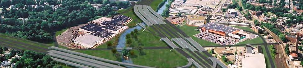
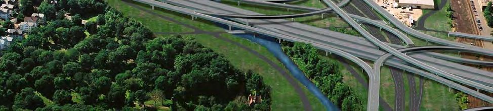
73 Figure 7-3: Alternative 8 Wilbur Smith Associates 71